What ho, you wonderful people, you!
I’ll not beat about the bush, let’s get straight to business! Over the past few months, when I had time, I spent some entertaining hours poring over any and all parish and other records relating to Glossop. Not just that, but estate records, royal tax records, and wills too… anything with a place and a date, essentially. I have been trying to establish the first mention of the farms and places that make up what we know as Glossop in order to get a feel for the place in the 16th, 17th, and 18th centuries. Why yes, yes I am that interesting.
Parish records were first introduced by law on 5th September 1538. From that point on the details of any event that took place within the church had to be recorded, and thus anyone baptised, married, or buried (hatched, matched, or despatched) were entered into a ledger (here is a good introduction to the subject). The details depended on the event, but it usually included a name, a date, and, crucially for us, a place: e.g. 14th June 1620, Jonah Wagstaffe, son of Charles and Elizabeth of Glossop, was buried.
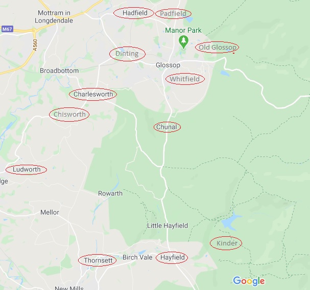
What follows is an alphabetised list of the locations mentioned in the parish records for Glossop All Saints parish church in Old Glossop. I primarily used the North West Derbyshire Sources site, run by the seemingly unstoppable Marjorie Ward. The website is an absolute goldmine of data for this area, so please do check it out. Also, all credit, and huge thanks, goes to the people who originally transcribed the parish records; it wasn’t me, and all I did was read them and extract some information – I merely stood on the shoulders of giants, to quote Newton (and others).
Glossop’s records don’t go back as far as 1538, sadly, but instead start in 1620. Why this should be is unclear, but it is not the only example from around the country; opposition to the process, a lack of direction, and simple laziness may all have played a part. Because of this, I also looked at any other forms of official records I could find – tax records, wills, land deeds, and what not, to see if I could push some dates back further. I will be adding to these data in future, especially as I come across earlier references to places, so think of this as a work in progress. I have used the modern spelling for the places, but have made a note of different spellings when they appear. Until relatively recently, there was no standardised spelling of words, and placenames in particular were spelled how they sounded, often reflecting the accent of the people, as is the case here (see Coombes and The Heath for good examples of a local accent preserved in the records).
Note that this is simply the first mention of these places, not the date they were founded. This may seem obvious, but it is important to state that many of these places will have been settled for hundreds of years prior to their mention in the Parish Records. This is underlined by looking at how many of the entries have a date of within 20 years of the 1620 commencement of the parish records – it is clear that they didn’t all just pop into existence at that point, and that the first mention of them here is just that. A big boom in the settlement of the area would have commenced in the 1530’s after Glossodale was taken from Basingwerke Abbey and given to the Talbot family – it would be in their interests to get as many rent paying farmers on the land as possible. That stated, the abbey was pretty good at making money and would certainly have encouraged the foundation of farmsteads, thus we can perhaps characterise the period following the relaxation of the forest laws as one of continual expansion.
A note on the sources: PR – Parish Records. Domesday Book – is fairly self explanatory. 1381 Poll Tax – information taken from the book ‘The Poll Taxes of 1377, 1379, and 1381’ by Carolyn Fennick (Glossop only features in the 1381 Poll Tax, oddly). Wills – from the North West Derbyshire Resources website. Kirk – papers of the Kirk family of Glossop and Chapel-en-le-Frith. Datestone – the datestone on the house. EPNS – any of the numerous records used in ‘The Place-Names of Derbyshire Vol. 1’ published by the EPNS. EPNS – Ch – is ‘The Place-Names of Cheshire Vol.1‘. Derbyshire Subsidy Roll 1327-8 (DAJ) – Another poll tax, published in the Derbyshire Archaeological Journal of 1908 (read it here, if you like). Roll of Fines – a list of people fined for offences against the forest, and dated to the 13th year of Edward I (1285), you can read it here (it’s the same source as the Forest Rolls (EPNS), but I have mined some more information that the EPNS left out). Shepherd’s Society – the list of members of that society that met in Glossop and Longdendale (read it here). Shrewsbury Papers – the public record office collection of the Earls of Shrewsbury’s papers (the Talbot family archive, essentially) – here.
| Place | Date | Person Named | Notes & Alternate Spellings | Source |
| Almans Heath | 1650 (22/7) | Burial of Elizabeth Timplie, widow | “Almens Heath” | PR |
| Ashes | 1674 (12/11) | Marriage of William Newton & Mary Newton | PR | |
| Bank | 1668 | Bank Farm on ‘The Bonk’ | Unpublished Ryland’s Charters (EPNS) | |
| Bankwood | 1717 | Hadfield. “The Bankwood” (Gate) (Bankswood) | Rylands Charters (EPNS) | |
| Bettenhill | 1637 (24/3) | Burial of Elizabeth Robinson, wife of Robert | “Betterside Hill” “Betterside the Hill” “Bettinside Hill” | PR |
| Blackshaw | 1600 | Will of Ottiwell Beard of Kynder (John Dande of Blackshaw is witness) | Wills. Also the burial of Anna Dande, wife of John 1621 (PR) | |
| Bridgend | 1598 | Will of William Barber of The Heath (Robert Bramhall of Bridgend is witness) | “Bridgent” | Wills. Also, Burial of Ann Brammall 1654 (PR) |
| Brown Hill | 1285 | “Brunhill” | Forest Rolls (EPNS). I’m not convinced, to be honest – Brownhill is a common name, & the physical evidence does not support 1285. Reference to “Sarah Hollinworth alias Brownehill” in 1624 might be this place. Definitely, though, Thomas Garside in 1807 in SS | |
| Castle Hill | 1692 (2/2) | Burial of Edward Hadfield (snr) | PR | |
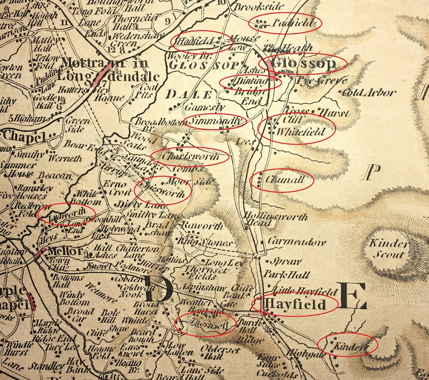
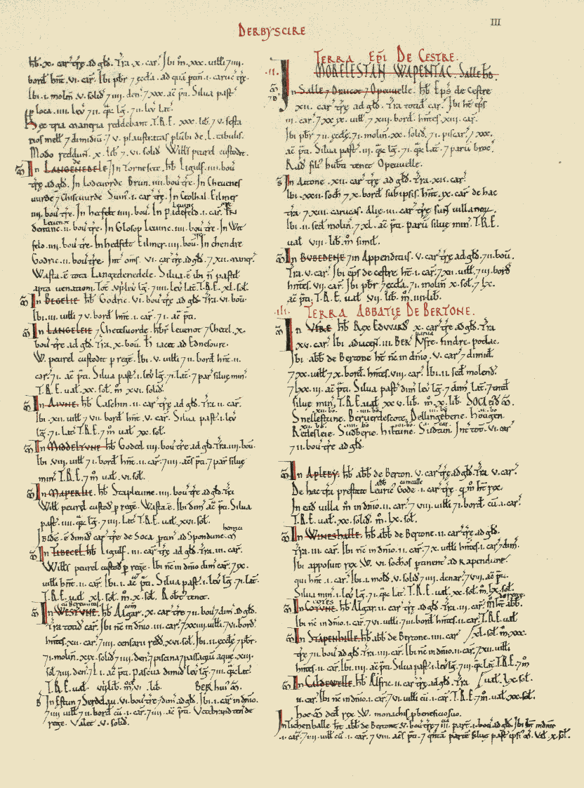
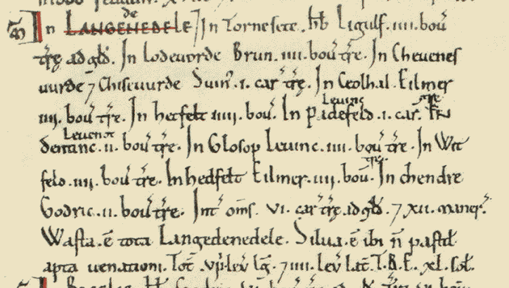
| Charlesworth | 1086 | “Cheuenwrde” | Domesday Book | |
| Chunal | 1086 | “Ceolhal” | Domesday Book | |
| Cold Harbour | 1627 (23/5) | Marriage of Otwell Clayton & Margaret Downes | PR | |
| Coombes | 1285 | “Chiselwrthecumbes” (1285), “Cowmbes” | Forest Rolls (EPNS). Also baptism of Anna Bridge, daughter of John 1644 (PR) | |
| Coombes Edge | 1700 | Burial of Elizabeth Booth | “Colmes Edge” Same as Cown Edge below? | PR |
| Cow Brook | 1643 (24/3) | Baptism of Joshua Dewsnap | PR | |
| Cown Edge? | 1702 | Baptism of Sarah Booth | “Cold Edge” “Coln Edge” | PR |
| Crosscliffe | 1555 | Edmund Bower of Whitfield | Lease in DRO (D5236/5/27) Also 1608 Calendar Rolls (EPNS) | |
| Deep Clough | 1285 | “Depecloxe” “Dupecloh” | Forest Rolls (EPNS). Also baptism of Nicholas Brammall 1620 (PR) | |
| Dinting | 1086 | “Dentinc” (1086), “Dintinge” | Domesday Book. | |
| Fieldhead | 1804 | Will of George Roberts (mentioned land at ‘Field Heads’ – presumably the same) | The position of Fieldhead Farm is literally that, at the head of the ploughed selions, now simply fields. | Wills. Also will of Jacob Hollingworth 1845 |
| Gamesley | 1285 | “Gameleslegh” | Forest Rolls (EPNS). Also Tax of Jurdan de Gamesley Derbyshire Subsidy Roll 1327-8 (DAJ) | |
| Glossop | 1086 | Domesday Book | ||
| Hadfield | 1086 | Domesday Book | ||
| Hargate Hill | 1623 (10/7) | Burial of Widow Robinson | “Hargatt Hill” “Hargett Hill” “Hardgate Hill (1654)” “Hardgate” might refer to a ‘Hard Road’, i.e. not muddy track. Roman? The road does pass by here. | PR |
| Heath | 1285 | John del Heath | Also as “Teathe” (3/11/1658) (PR) | Roll of Fines. Also Robert del Heth, Derbyshire Subsidy Roll 1327-8 (DAJ) |
| Herod Farm | 1703 | Datestone | ||
| Hilltop | 1679 (27/7) | Burial of John Hadfield | Caution… there is also a Hill Top in Chisworth (EPNS). | PR |
| Hobroyd | 1327 | Wills de Holberode | “Hob Road” “Hobrod” – road rather than royd? | Derbyshire Subsidy Roll 1327-8 (DAJ) |
| Hollinworth Head | 1546 | Hollingworth Head Farm | Unpublished documents in the Middleton Collection (EPNS). Also burial of Emmot Taylor, wife of Ralph 1623 (PR) | |
| Hurst | 1550 | “Whitfield Hurst” | Feet of Fines (EPNS). Also baptism of Robert Hagh in 1621 (PR) | |
| Hurstnook Farm | 1772 | Datestone | ||
| Jumble | 1640 (1/4) | Burial of Grace Turner, wife of Reginald | “Jomble” | PR |
| Lamyclough | 1629 (8/12) | Burial of William Newton, son of Hugo | “Lammanclough” & “Lammeclough” – Charlesworth way | PR |
| Lane Ends | 1623 (14/12) | Burial of John Robinson | Whitfield | PR |
| Laneside | 1625 (14/9) | Burial of John Bramall | PR | |
| Lee Head | 1706 (12/1) | Burial of Thomas Harrison | Charlesworth | PR |
| Lees Hall | 1285 | Jo. de Legh (of Whitfield) (John de Legh) | Also Ricardus del Lees 1381 Poll Tax | |
| Little Padfield | 1711 (5/1) | Baptism of Elizabeth Creswick | PR | |
| Long Lane | 1696 (24/6) | Burial of ‘Old Widow’ Boedon | Charlesworth | PR |
| Long Lee | 1621 (17/9) | Burial of George Hyde | PR | |
| Mill Town | 1643 (27/6) | Burial of Margaret Mellor, wife of Ralph | PR | |
| Monk’s Road | 1290 | “le Cauce” (The Causeway) | Calendar of Charter Rolls (EPNS) | |
| Moorside | 1616 | Will of Thomas Hollingworth of Moorside. | This may be Moorside in Chisworth, confusingly. | Wills. Also burial of Widow Hollinworth 1623 (PR) |
| Moregate | 1655 (2/4) | Baptism of Helena Hadfield | Hadfield | PR |
| Mossy Lea | 1623 (5/1) | Burial of Ellina Hollinworth | “Mosseley” & “Moselee” | PR |
| Mouselow | 1628 (16/11) | Baptism of William Newton | PR | |
| Over Deep Clough | 1709 (19/1) | Burial of Henry Hadfield | PR | |
| Padfield | 1086 | Padefeld | Domesday Book | |
| Pike’s Farm | 1780 | Datestone | ||
| Priest’s Pastures | 1616 | Petition to the King by a “Nicholas Hatfielde” | “Prist Pasters” – Padfield somewhere. | Shrewsbury Papers, Folio 147 (no date, but the recipient, Gilbert, died in 1616, so before then). Also 1640 (20/2) – Baptism of Anna Hadfield (PR) |
| Pyegrove | 1631 (15/1) | Burial of Anna Booth, daughter of Ralph & Anna | “Pigreave” “Pyegreave” | PR |
| Reaps Farm | 1631 | Burial of William Hadfield, son of William & Helen | “Reape” | PR |
| Ringstones | 1623 (13/5) | Baptism of Thomas Roobotham | PR | |
| Rowarth | 1285 | Roger le Ragged de Roworth | “Rouworth” | Roll of Fines. Also Burial of Elizabeth Goddard, wife of Robert 1626 (PR) |
| Shaw | 1285 | Mathew del Shawe | Roll of Fines. Also Henricus del Schawe 1381 Poll Tax | |
| Shelf | 1285 | Possible location of Monastic Grange? | Forest Rolls (EPNS). | |
| Shire Hill | 1285 | “Shyrhull” | Forest Rolls (EPNS). | |
| Simmondley | 1285 | Alward de Symondesly | “Symondlee” | Roll of Fines. Also Burial of Joanna Beelee, w. of William 1620 (PR) |
| Spire Hollin | 1700 | “Spire Hollin estates” mentioned for sale in D513/M/E/374 with others. | Kirk Estate Papers #374. Also 1734 Poll of Derbyshire (EPNS) | |
| Storth | 1578 | Harry Booth of Storth Farm, Simmondley | He had dispute with Lord Talbot & went to London to see Queen Elizabeth I. | Historical record. Also Baptism of Joseph Botham, son of Henry & Mary, 1638 (PR) |
| Top of the Hill | 1698 (17/6) | Baptism of Robert Wagstaffe | By Redgates | PR |
| Torside | 1621 (16/7) | Baptism of Alycia Hadfield | “Thorsett” | PR |
| Waterside | 1710 (19/5) | Burial of Ann Alsoppe | Hadfield | PR |
| Whitfield | 1086 | “Witfeld” | Domesday Book | |
| Whitfield Barn | 1657 | Datestone | ||
| Whitfield Hough | 1690 | Robert Dewsnop of Whitfield Hough | Title deed in Dro (D6368/1) | |
| Wimberry Hill | 1807 | John Winterbottom | “Bilberry Hill” | SS |
| Windy Harbour | 1683 (11/12) | Burial of Thomas Harison | “Winde Harbar” | PR |
| Woodcock Road | 1249 | “Wodecokessich” (1249) “Wood Cockrode”, “Cockroode”, & “Cock-Crowd” | Calendar of Inquisitions Miscellaneous (EPNS). Also baptism of Joseph Bramall 1628 (PR) | |
| Woodhead | 1424 | Cholmondley Deeds (EPNS – Ch). Also baptism of Anna Bostocke 1629 (PR) | ||
| Woodshead | 1654 (13/9) | Baptism of Elizabeth Heawart | “Woodsheds” in Charlesworth | PR |
| Wooley (Bridge) | 1286 | Court Rolls (EPNS – Ch) |
And there we have it. Obviously buildings within these areas will have separate dates, but overall we can begin to picture Glossop as it was in the medieval and post medieval period.
Visually then, it looks like this:

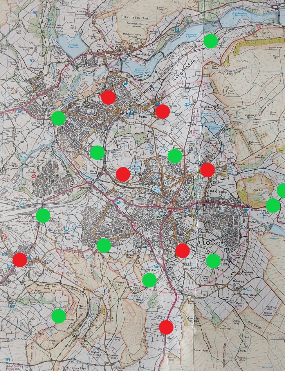
By 1285, Glossop looked like this:

By 1450, very little has changed:

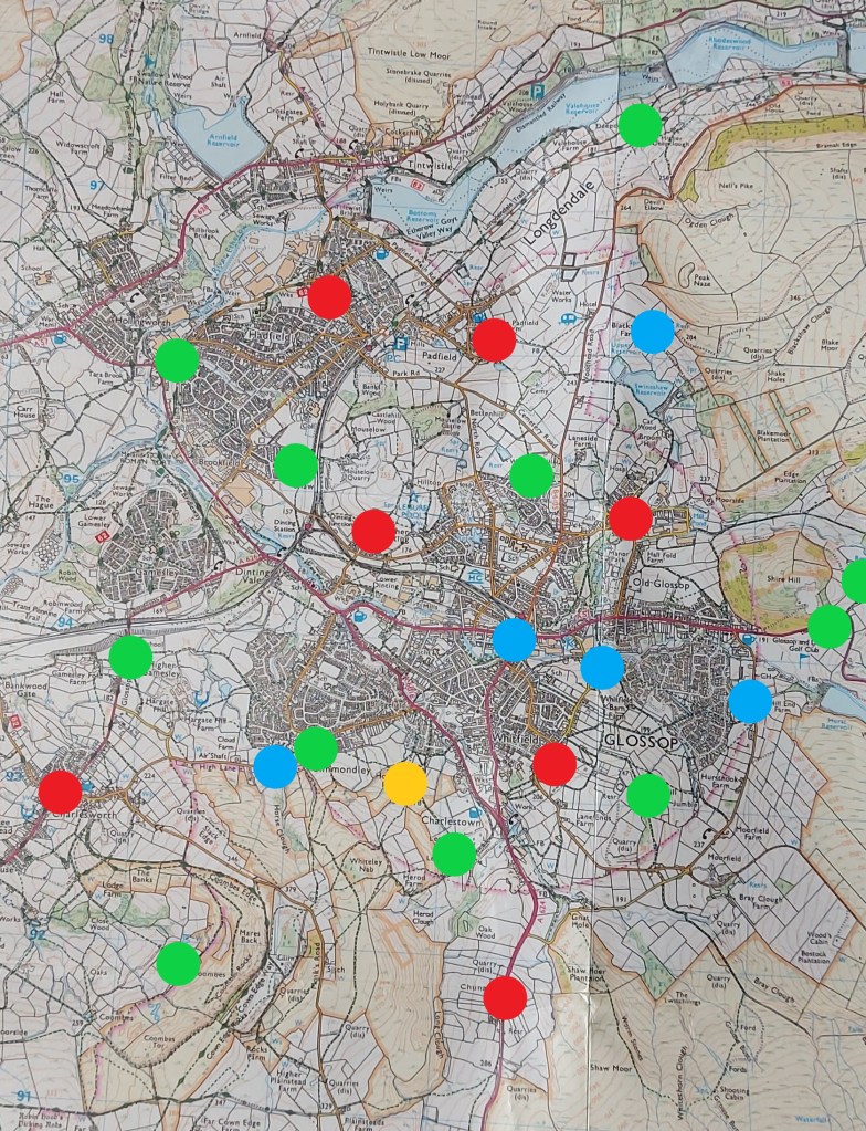
Following the Dissolution of the Monasteries from 1538 onwards, the land becomes the sole property of the Talbots who continue to encourage the founding of farms. Here is the situation by 1620:
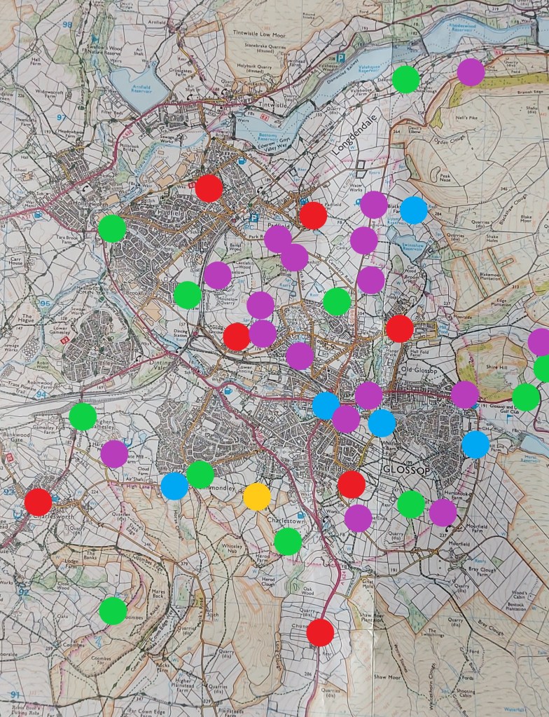
100 years later, the land is full of smaller farms, all paying rent to the landords, now the Howard family. The explosion in farms may be connected to the Howards drawing up longer rental leases, allowing people to invest in buildings and land not just for themselves, but for their children and grandchildren. Here is the situation in 1720:
Obviously, this is a very broad study – I just want to get the information out there. There is an awful lot more that could be done here, not least of which could be some form of more formal survey of the land deeds. It should also be pointed out that many farms will have disappeared over time, forgotten about or subsumed by larger farms, and what we have here is not a 100% accurate reflection of Glossop, merely a snapshot.
More research is needed indeed… but for now, I’m going to have a snifter of the stuff that cheers.
Right-ho, that’s your lot for this time. Next time I promise more pottery… I know how much you’ve missed it. Until then, take care of yourselves and each other.
And I remain, your humble servant.
TCG