Placenames · Simmondley · Waterways of Glossop

Bridgefield

Good evening.

(well, it is here and now, but I suppose it depends on when you are reading this… in which case, feel free to substitute “evening” for whatever part of the day you happen to be reading this.)

Perhaps I should start again.

What ho!

A short one today – I realise that I haven’t been as active as I’d like, so rather than labour over a larger post, and as a sort of proof that I’m still alive, I present today’s smaller offering – the area of Glossop known as Bridgefield. This is a place you drive through without ever noticing it is there – blink and you miss it as you go from Charlestown to Dinting along Primrose Lane. It is also a great example of why maps are so useful as a record of places – without it being drawn on the map, it is likely that Bridgefield would have ceased to be remembered as a place at all.

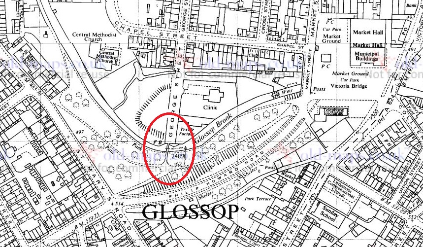
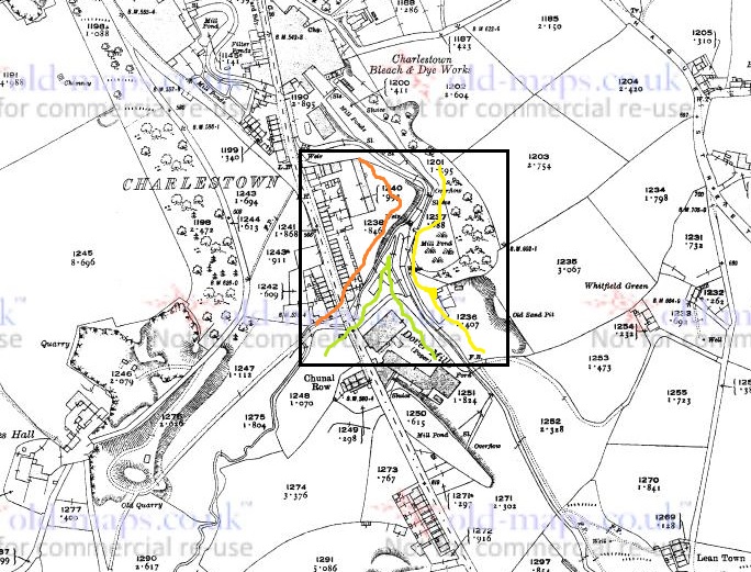
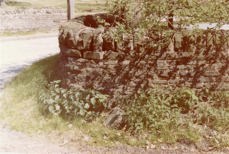
I have commented elsewhere that older names for places are usually based on reality, and reflect a different set of priorities – largely truthfulness in description: Gnat Hole was not named ironically, and so it is with Bridgefield, it was – and is – the field with the bridge. Well, actually bridges, plural – there are two. The first is where Primrose Lane crosses Long Clough Brook, circled in blue on the map below. But it is the second one – a small footbridge over the Long Clough Brook – that I think is the more interesting of the pair, and is indeed the older. Moreover, it actually is in the ‘Bridge Field’, rather than two fields over. And so, this humble little bridge is the target of today’s fevered ramblings. The bridge, or to be precise an earlier incarnation, is circled in green in the map below.

A rather colourful rendering. The bridge of Bridgefield is marked in green.

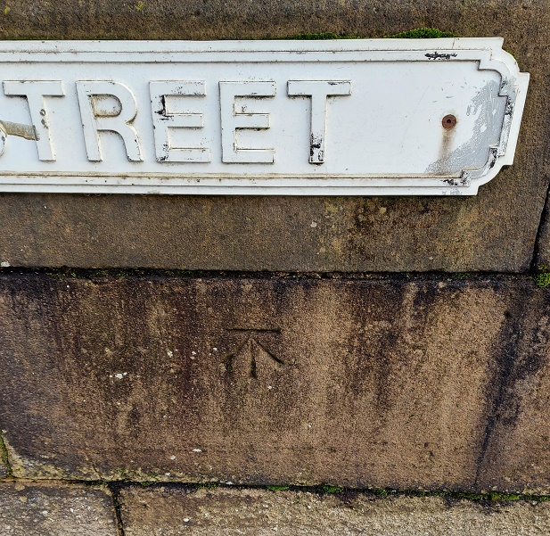
It crosses Long Clough Brook at the bottom of Slatelands Road, and now forms the bottom end of a footpath from Pikes Lane, emerging into Primrose Lane. This track – marked in red in the map above – wends its way between houses and land, and is known locally as the Chicken Run; indeed it still has chickens at the bottom. It was also known as the ‘Giggle Gaggle’, apparently, which recalls strongly the ‘Gibble Gabble’ in Broadbottom – another track that wends its way between houses and land. Indeed, it is suggested that Gibble Gabble (and thus Giggle Gaggle) is a localised (Mottram, Broadbottom, Glossop) dialect name for what is known elsewhere as a ‘ginnel’ (a track that wends its way between houses and land), which makes sense (here is a little more on the subject). According to A Journey Through Glossop by Kate Best and Owen Russell this same trackway was also known as Burneen by the nuns of the convent on Shaw Street, who used it to get to Hobroyd. Burneen is a version of the Irish term, Boreen, which means… anyone? Anyone? That’s right – a track, usually one that wends its way between houses, etc. There is a theme here… if only I could spot it. David Frith in his Pathwise in Glossop and Longdendale (p.60, Path 40) notes that this path went through allotments, and was known as the ‘Flagged Fields’, again strongly suggestive of a maintained trackway or road.

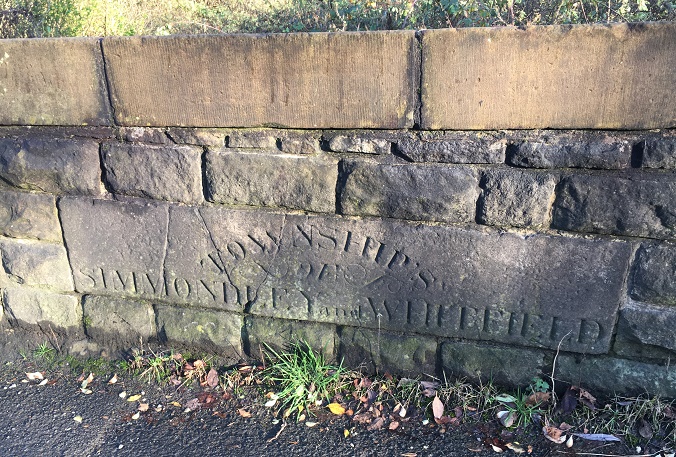
Joking aside this track is very important; I am convinced it forms part of the medieval road (such as it was) between Charlesworth, via Simmondley, to (Old) Glossop. The track goes along Old Lane in Simmondley (the name is a clue), down a sunken trackway that might indicate both age and heavy use, and emerges along another ‘fossilised’ footpath, preserving the original trackway ‘in stone’ – here, at the bottom of Simmondley New Road and Moorside Close:

The tail end of the track that comes from Charlesworth via Simmondley (Old Lane).

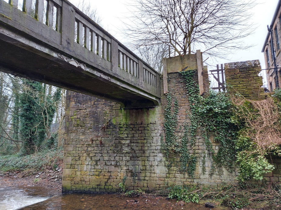
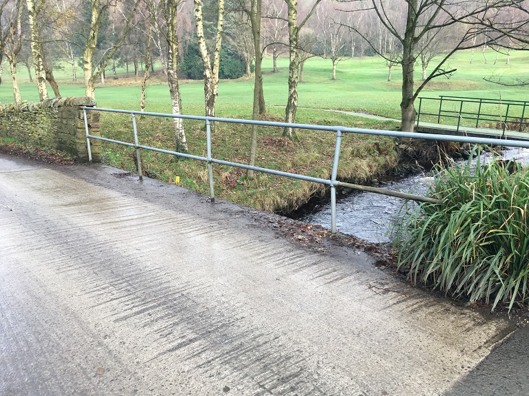
It continues along the footpath until it meets Pike’s Lane. This track will be the subject of a future blog post as it is a vital part of the history of the area, and well worth an explore, but for now let’s return to the bridge. Here it is, then, the current bridge of Bridgefield.

The bridge over the brook.

This bridge is quite modern, being made from rolled steel ‘I Beams‘, and it is clearly the latest in a long line of bridges of various sorts.

It works as a bridge, but it’s certainly not romantic.

We may assume that the earlier bridges were made from stone in one form or another, but looking into the brook, I noticed some large flat stones – much bigger and more substantial than paving slabs – that look out of place.

They’re not easy to make out, but the slabs are dotted along this stretch of Long Clough Brook, directly below the bridge. Incidentally, the Brook marks the border between Whitfield and Simmondley – as we look at the photo above, Simmmondley is on the right, Whitfield left.

Am I wrong to imagine that these once might have made up the medieval and early modern bridge in the form of a Clapper Bridge? The stones having fallen, but not moved very far by man or water.

A Clapper Bridge. This example is at Postbridge in Dartmoor, but they are a common way of forming a river crossing, especially where the banks are high – as they are at Bridgefield.

If I’m honest, I probably am wrong; the whole area has been extensively messed around with by the building of mills and mill ponds, as well as work on the brook itself with the building of weirs and shaping the banks. It’s difficult to get an idea what the area would have looked like, and it’s unlikely that any vestiges of the original bridge remain. But still, let’s imagine.

EDIT

Actually, further evidence to support the Clapper Bridge idea might be suggested by the fact that Slatelands Road, which runs down to the bridge, was once known as ‘Stoney Causey‘, the Stoney Causeway. The word ’causeway’ normally indicates a raised roadway across wet ground, as opposed to a bridge per se. which would fit quite nicely.

However, the importance that was once given to Bridgefield is underlined by the fact that the Reverend John Wesley, the founder of Methodism, preached here. Now, that Wesley preached in Glossop is not in itself big news – he preached all over, favouring the open air, and had a fondness for this part of England, returning time and again to spread the word of his particular brand of Christianity. But the fact that he chose Bridgefield as the location for the crowds of people that would have gathered – some jeering and making mock, others listening intently and converting – is significant. It indicates that this was an important place, and vital in communicating between towns – Glossop and Charlesworth/Simmondley, but also one that was well known enough that people all over Glossop would come and hear him. In his diary, Wesley records the following entry:

Friday, 27th March 1761
“I rode to Bridgefield, in the midst of the Derbyshire mountains, and cried to a large congregation, “If any man thirst, let him come unto me and drink.” And they did indeed drink in the word, as the thirsty earth the showers.”

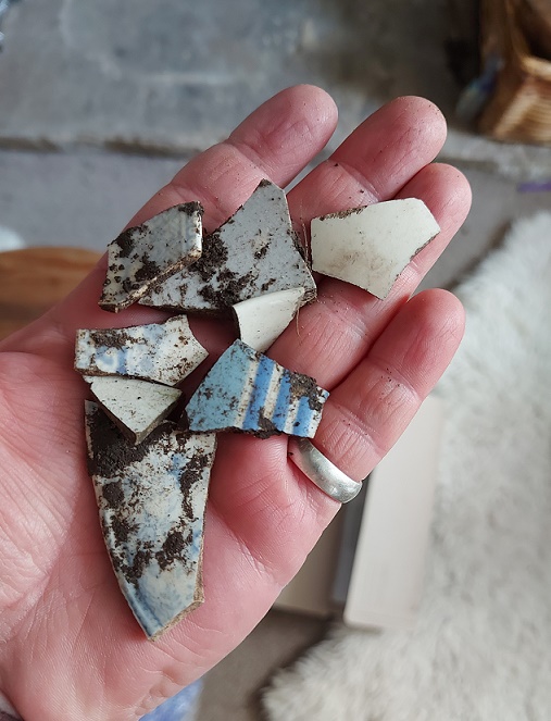
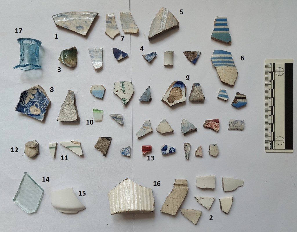
Well there you go. Who knew that this often overlooked corner of Glossop had an interesting history. As I say, I’m going to blog about the Charlesworth to Glossop track in a future post as it’s a hugely important thing, and part of a larger project that is trying to identify all such trackways in the immediate area. I also recently did some mudlarking in Long Clough Brook, so should probably post the results.

Right, until next time, please take care of yourselves and each other.

I remain, your humble servant.

RH.

Archaeology · Pottery · Waterways of Glossop

A Bridge Over Troubled Water…

Blimey! January flew by, and so did February. Apologies for the lack of activity on the blog of late, I’ll be back to more regular posting from now on. What ho! Well here we are, once more in lockdown. I know its for the greater good, and you’d be a fool – and indeed a dangerous moron – not to follow the rules… but dash it all, it’s starting to be a bit of a bore! Right, once more with a glass of the stuff that cheers here we go.

Whilst perusing the local history section of the library – during the heady days when such a thing was possible – I came upon an architectural drawing of the bridge over Glossop Brook at the end of George Street – officially known as ‘Coronation Bridge’. Now, those of you that know the bridge will also know that it isn’t the most lovely bridge in the world – it’s hidden away in the dark damp recesses of Harehills Park, covered in graffiti, and surrounded by the waste ground.

The location of the bridge is circled

But let’s look again, I say, as I think there is a hidden beauty here – a ‘rough diamond’ of sorts, only made of reinforced concrete. First, here is the architectural drawing:

It’s a very Art Deco style drawing, and quite fetching.

And here is the bridge as it is now:

Not the most attractive looking bridge, but I think it has a certain charm.

Comparing the plan with the actual bridge, they really did a good job. It is an understatement to say that I dislike concrete, but this has a certain Art Deco feel about it, and I honestly think it would look pretty good scrubbed up.

It is fairly forlorn, and could really do with a scrub up.
I like to imagine that the historical spirit of a place affects modern perceptions through things like graffiti: the foundry that once stood here would have been an extremely hot work environment – Hell Fire indeed.
Concrete, close up.
I particularly like the pink Mickey Mouse graffiti. What? It must be Mickey Mouse… look at the size of those ears.

The architectural drawing is dated 1928, so we might assume that it was built soon after that to replace the original Coronation Bridge, a railway footbridge that was presented to the town by Lord Howard in 1902 to celebrate the coronation of Edward VII. That bridge, notes the original Robert Hamnett, replaced other bridges that had been washed away numerous times by flooding. Now, far be it for me to question the original Mr Hamnett’s facts, but I can see no trace of these bridges on any of the earlier maps. For example, here is the area in 1880:

1880 1:500 scale. George Street is top centre, and you can see Shepley Mill and the George Street foundry.

Is it possible that he made a mistake?

Harehills Park is interesting in itself – I won’t go into too much detail, as the Glossop Heritage Trust has an excellent article on its history which you can read here. It has been known variously as Harehills Wood, Harehills, the People’s Park, the Sandhole, and Pinch Belly Park. These last two names are derived from the fact that during the ‘Cotton Famine‘ of the early 1860’s – a situation caused by the lack of imported cotton from America due to the ongoing Civil War there – men were employed there digging sand in order to provide work for them. In 1921 the park was given to the people of Glossop by Lord Howard in appreciation of the men of Glossop who served in the First World War, but also as a memorial to his son Philip Fitzalan Howard, a lieutenant in the Welsh Guards who died of wounds in France on 24th May 1918. The park was extensively remodelled and landscaped at this time, including the construction of the bridge, and was used as a recreation grounds and promenading area. Prior to this, the area was described as “hideously ugly; hen pens fenced with old fish boxes; old salmon tins, rhubarb roots, and a good quantity of other rubbish with plenty of muck and sludge thrown in”, and was known as a place for bare-knuckle prize fighting. It was also noted that “one part of it seemed to be nothing more than a vast tipping place”, and it is this part, one assumes, that keeps producing pottery. It has a been a particularly fruitful site to find pottery, to be honest – none of it too old, but its always there.

Prior to washing.

One assumes that the pottery has not travelled very far from the place of use, and so we might suggest that much of this rubbish came from the houses on St Mary’s Road, allowing us a peak into the lives of those living there. A more systematic approach and proper archaeological investigation could tell us a great deal – this is essentially what we, as archaeologists, do with pottery. Anyway, the sherds:

Fairly standard Late Victorian and Edwardian stuff, all from Harehills Park.

I’m not going to lie – a lot of it is pretty dull stuff, but there are some interesting bits and pieces, and this is a slice of domestic life in the Victorian and Edwardian periods.

  1. Plate or soup bow1 with an undulating rim of c.20cm, and a poor quality light blue transfer printed pattern – the transfer doesn’t match up at the join. Mid/Late Victorian
  2. 5 plain white rim sherds of 14, 8, 18, 16 and 16cm. Saucers, plates and cups. Victorian – 1920’s
  3. Fragment of a green glazed Majolica vessel, possibly vegetable-based. Utterly grotesque!
  4. Tiny fragment of a Sponge Ware decorated vessel. A rare occasion where I don’t know the shape – it has a carination in the body, so possibly an early mug or teacup. Victorian.
  5. Stone ware vessel, possibly a badly glazed marmalade pot – it has the grooves, but the surface is poor quality. C. 12cm diameter, so probably.
  6. 4 sherds of Annular Ware, Early to Late Victorian. This stuff starts much earlier than you expect (1780’s) and it looks almost modern.
  7. 2 sherds of a teacup rim, c.7cm rim diameter, and transfer printed on interior and exterior. Victorian.
  8. Base to a transfer printed willow pattern plate. Base diameter is 10cm, so the plate would be at least 10cm. The print shows a pagoda in the standard willow pattern style. Victorian.
  9. Rim sherds of 2 different Feather Edge bowls. Both date to between 1840 and 1890.
  10. A tiny fragment of green and white art glass bowl or cup, with an undulating rim. I quite like this.
  11. A saucer rim with a single green line below the edge. Refined, and quite nice. 12cm diameter.
  12. Handle to a whiteware cup. Quite fancy, and possibly Early Victorian. Or possibly not… this stuff is difficult to date properly.
  13. Red glazed rim to a jug or similar. Victorian.
  14. Flat glass shard with vertical (horizontal) grooves in, slight greenish tinge. Possibly the lens to a torch or car headlamp.
  15. Base and body of a porcelain teacup c.8cm in diameter, straight sided, 1920’s.
  16. Base and rim to 2 marmalade jars – base is 10cm diameter, rim is 11cm, Victorian to Edwardian.
  17. A beautifully coloured pale cobalt glass bottle. This is probably from a medicine bottle, and has what is called an ‘applied lip’, which means that the rim was made separately, and then melted onto the blown glass body. This is an inelegant solution to the problem of removing a blown glass bottle from the tube and leave a proper opening, and you can see the two parts twisted and melted together on the bit between the neck and shoulder in the next photo. You can read more about bottle finishings here:
Artful shot… shot, artfully.

What is also nice is that 3 sherds have maker’s marks on the bottom, allowing attribution and dates.

It’s not often I find maker’s marks. Nice.

Top sherd is marked either ‘Stone China’ or ‘Ironstone China’ which is a type of pottery that contains crushed feldspar in order to make it very strong and hardwearing. It was developed from about 1800 onwards, and this sherd is probably mid-Victorian. Bottom left is ‘Tuscan China’ made by RH and SL Plant at the Tuscan Works, Staffordshire. The logo dates it to the 1920’s and 1930’s, and was presumably broken and thrown away anytime after that, although presumably before the landscaping of the park. The bottom right is marked ‘Melba Bone China – Guaranteed Made In England’, and was made by Mayer and Sherratt, based in Longton, Staffordshire, and who operated between 1906 and 1941. So there you go.

Do have a look at the bridge the next time you go over or near it, as I think it deserves a closer look than it currently gets, and I hope that in the near future more is made of the area. Until then, look for pottery in the soil around the bridge, and think about mudlarking the bank of Glossop Brook there – I’m sure you’ll find something, but make sure you let me know what.

That’s all for this time. Apologies again for the lack of activity – real life has an annoying way of getting in the way of what you really want to do, but I will be posting more frequently… promise. Also, please do get in contact, for what ever reason, and follow me on Twitter too – I am quite active there. I am also working on a YouTube channel, where I can put videos of walks, mudlarking, digging, history bits, finds, and other shenanigans – it’s in the early stages, but I think it could be fun, but also a way of getting you all involved. Anyway, more soon, but in the meantime please take care of yourselves and each other – even just a cheery smile at your neighbour can make all the difference in these troublesome times. Until the next time I remain.

Your humble servant,

RH

Bench Marks · Stones of Glossop · Towns of Glossop

A Bevy of Boundary Stones

Ho! Ho! And if I might dare, What Ho! A shortish one today, and actually one that is something of a relief, if I’m honest. Like the last post, this one has been years in the making, but this time for all the wrong reasons… all will become clear in a moment, but for now let’s crack on.

As the title suggests boundaries are today’s topic, apt as we hurtle to the Winter Solstice and the shortest day – that anciently observed boundary between the old year and the new. Boundaries such as these are often held to be dangerous places as they are a liminal space – neither one thing nor another, but somewhere in between. However, boundary stones in particular I find fascinating and strangely appealing objects; there is something very grounding about them in that they mark in a clear, permanent, and fixed way, an imaginary line. On one side ‘X’ and on the other ‘Y’, and there is no argument – the somewhat liminal boundary is made visible and real, and so it is the case with our stones today – three stones placed on bridges over various waterways delineating the townships that make up Glossop

All three, it seems, were carved and installed at the same time, and all are quite old – early Victorian. The first of the stones is the easiest found – Victoria Bridge in the centre of Glossop.

Bount
Station at the top, above the High Street crossroads. The bridge over Glossop Brook, and the stone, is circled in orange. Glossop is north of the Brook, Whitfield is south. 

And here it is in real life.

Boundary St
Victoria Bridge. Wetherspoons is in the background, and Glossop Brook runs beneath.

The bridge, and the stone, stand over Glossop Brook, which disappears under the market place and carpark, and the line carved between the words Glossop and Whitfield is the centre line of the brook below. Victoria Bridge was built in 1837, the year Queen Victoria ascended the throne, hence the name. This new bridge replaced an old and narrow hump-backed pack-saddle one. Indeed, the original line of the road that led over the bridge, down Smithy Fold, and along Ellison Street is traceable, and is preserved particularly in the buildings of the Brook Tavern, Cafeteria, Glossop Pizza, Balti Palace (all built in 1832). I have a blog post almost finished that looks at this area in more detail, so I won’t go into it here.

Looking closely, the inscription “Victoria Bridge” and the date “1837” are in a different font and slightly larger than the other lettering on the stone, and are more cramped, and it seems they were added at a later date. Indeed, compare this stone to the one below, and you can see they both once looked the same. 

And of course, it wouldn’t be the Glossop Cabinet of Curiosities without a bench mark, this one on the bridge and just to the left of the boundary stone. 

Victoria Bridge
This is what 495.7 ft above sea level looks like.

The next stone is to be found on Charlestown Road, on a bridge over Long Clough Brook – it’s very much a blink and you’ll miss it kind of affair, even if you are walking. 

Bounty
Turnlee and Charlestown Roads join at the top, with the boundary stone circled in orange.
bound3
Here is the bridge over Long Clough Brook on Charlestown Road. The stone is visible.
bound1
Here it is in close-up. Can you spot a mistake?

This stone follows the same formula as the Victoria Bridge stone, but is slightly rougher in execution. It seems to have been reset into a rebuilt stone wall at some stage, as it doesn’t really match the coarse  surface of the stone around it, and this resetting might explain the cracking. It also has an inexcusable mistake… there’s a bloody apostrophe after ‘township’! It should read ‘TOWNSHIPS’, the plural of township, but instead it reads that ‘Township’ owns something called an ‘of Simmondley and Whitfield’! Also, although it states that this is the boundary between Simmondley and Whitfield, it technically isn’t. This is the border between Chunal and Simmondley, but it seems that for administrative purposes, Chunal and Whitfield were often lumped together. The confluence of Bray Clough (from Gnat Hole) and Long Clough Brook (just east of the boundary bridge) is actually the meeting of the three townships of Chunal, Simmondley, and Whitfield, here:  

bounty2
The three townships illustrated at the junction of Bray Clough Brook and Long Clough Brook. Chunal in green, Simmondley in red, and Whitfield in yellow.

So far, so good.

Now, the third and final stone was a bit more of a mystery. According to Neville Sharp (Glossop Remembered p.184 – a great book, by the way, well worth seeking out – here for example, but order it from Bay Tree Books on the High Street, of course), a stone similar to the one on Victoria Bridge stood on the bridge over Hurst Brook which forms the north eastern boundary between Glossop and Whitfield. That is until it was washed away in a flash flood.

Bound4
High Street East at the top, with Derbyshire Level running from the Royal Oak off the map at the bottom. The word stone on the bridge over Hurst Brook is circled.

Then, whilst doing some research, I came across a reference to the stone and made a note in my notebook that until at least 1977 the stone stood next to the entrance to Golf Course. Annoyingly, I didn’t take down the reference and it’s taken me 3 years to track down the source of the information. Three years! Such is the level of detail and dedication I devote to this blog in order that you, gentle reader, can revel in such a fascinating subject as “bits of old plate” as it was once described by the person who runs the ‘Official Glossop‘ twitter account. Honestly, the nerve of some people…

So I re-found the source – this website – and blow me if it didn’t have a link to photographs of the stone taken in 1977:

Boundary Stone 1 (1977)
Entrance to the golf course on Derbyshire Level, the boundary stone bottom centre, in the glorious sunshine of the summer of 1977


Boundary Stone 2 (1977)
Close up of the boundary stone with part of the word ‘Glossop’ visible. Please note that I don’t have the copyright to these photographs, and make no claim to such, they are merely ‘borrowed’ from the above site.

The stone was presumably recovered, in its broken state, and set up on the side of the Golf Club entrance, and whilst it doesn’t look like there is a lot left I went to have a look.

Boundary St1
The same view as the first photograph above, missing the important piece.

Alas… the stone is no longer there. I had a good look around at all the stones that might be a possibility, but to no avail. I suspect that someone has taken it – it was a nice piece of stone after all, but it is a shame. All is not negative, though, and from the 1977 photograph we might suggest where it originally stood; the fact that the fragmentary word ‘Glossop’ is visible at the left hand end of the stone means that it could only have stood at the eastern side of the bridge, closest the golf course, for it to make geographic sense – Glossop is north, Whitfield is south at this point. Here, in fact:

bound2
Here. You can see the modern(ish) bridge that must have replaced the one that was washed away. Here, Hurst Brook separates Whitfield (right) from Glossop (left).

Its fragmentary nature also suggests that more of it lies in the stream bed – I had a look, but couldn’t see any likely stones, but perhaps next summer I’ll have a poke around. 

Right ho, that’s all for this time. Hope you enjoyed a ramble around the boundaries, and in fact I am writing a blog post that actually covers the boundaries of medieval Glossopdale based on a 13th century perambulation. I’d also like to do another that looks at the boundaries of all 10 townships of Glossop as they are in the Domesday Book, which could be a bit of fun. ‘Could‘ being the operative word here. And ‘fun‘ being an entirely subjective concept, I realise. But you, kind and gentle people, know what I mean… after all, you’re reading this. Please drop me any thoughts or hints, even to point out my mistakes, or the fact that I need a haircut. Take care of yourselves and each other, have a very merry Christmas, and until next time, I remain.

Your humble servant, 

RH