What ho, you wonderful and slightly strange bunch, you.
A quick one today… I have had almost no spare time to do much more. I have just finished the new edition of Where/When (No.4, The Melandra Meander) – which has taken all my time – and I’ve just started a new job! Busy busy busy! But the Cabinet of Curiosities is a priority, and you, kind and gentle readers, are very important. Plus, if I don’t publish something on the website, angry crowds start to gather outside my house, chanting and making threats – I mean to say, one has to think of the neighbours.
So here we are – a second part to the Datestone post I wrote 3 years ago (three years? Where has the time gone?). I’ll spare the introduction as the original covers that, and just dive in to say that all of the datestones are pre-Victorian (before 1837) – I’d like to do a survey of the datestones of the Victorian and later periods, but there are so many that it would be a big task. If anyone fancies giving me a hand, though, give me a shout.
So then, first up is a correction. Hurstnook Farm has a stone that I drew through a pair of binoculars, as I couldn’t get close enough to photograph it. Well, they’ve been doing some work there recently, and me being me, I wandered over and asked if I could take a snap, and Lo! The result is below.
F.S.M.W, and the date of 1772. Lovely detailing, too – this is an expensive looking stone.
And a wonderful datestone it is, too. Different from my interpretation of it, and I still have no idea of the names; W is probably the family name – possibly a Wagstaff? I’m sure looking through some deeds would produce a name, though. Any thoughts, anyone? There is another datestone on the extension next door that reads 2010, but is designed to copy the original one, to fit in with the building.
Next up is #13 Padfield Main Road, Hadfield.
J.H.A 1826. Simple and effective.
A simple datestone, but I honestly love this one. And the colouring is effective.
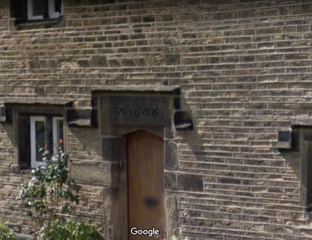
Next up, Hadfield Hall – a truly wonderful building. I could study this place for hours, and often find myself marvelling at the structure, and all the phases of construction. Now is not the time for a detailed look at the hall – a future post, perhaps. Still, it has a cracking datestone above the door.
I(J).H. T.A. 1646
Lovely stuff. Hadfield family? I’d love to know more – any thoughts?
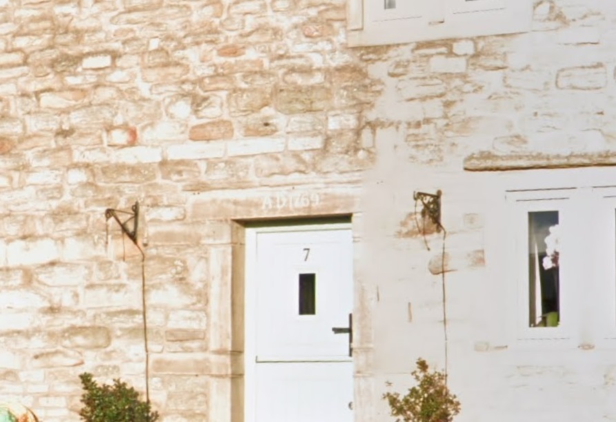
Just opposite Hadfield Hall is 7 Old Hall Square:
AD 1769
A simple date, rather than a chance at immortality.
Next we have 2 from Shaw, the farmstead that is first mentioned in 1285. It forms one of a number of such places dotted around Mouselow, and is a fascinating place. I suspect there is a lot of history here, and would love to have a poke around some of the properties there. If anyone reading this in Shaw fancies letting a slightly odd bloke have a rummage, so to speak, shout out!
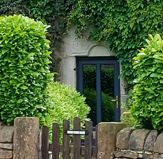
First is Shaw Farm Barn
G.B. (D) M.B. (B), 1694
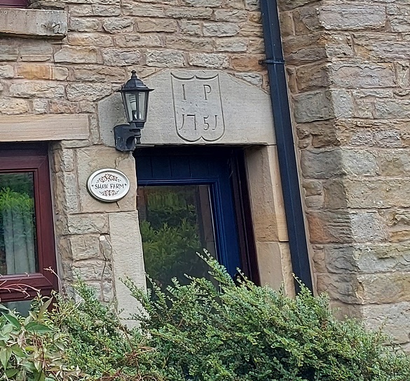
Not a great photo, but the inscription is correct. It’s on a whacking great lintel, which is very suggestive of an earlier, perhaps Tudor, door lintel that’s been re-used. Makes you think… And then, next door, is Shaw Farm:
I (or more properly J).P. 1751, in a rather fetching shield motif.
The names here again escape me – J.P. (the ‘J’ is rendered as an ‘I’ as was the custom).
Next up, the Hare and Hounds, Simmondley.
G.B.P. 1784
I actually know the meaning of those initials – George and Peggy Booth. Also in Simmondley, we have Dingle Cottage which sits on the old trackway from the farms over Whitley Nab way.
M.L.R. 1706
A truly fascinating building, and again, one in which I wish I could have a poke around!
Next is Hall Fold Farm, Old Glossop.
J.S.J.G. 1806
The datestone was apparently found buried whilst the farmhouse was being renovated. The image is not mine, but was taken from the always interesting (and essential if you like Glossop’s history) Old Glossop History Trail website. I want to take one of my own, but oddly people view Herberts taking photographs of their houses with a bit of suspicion!
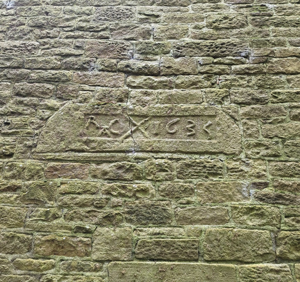
Another Old Glossop datestone is unusual – this is built into the side of Hillside Cottage, down by Laneside Farm:
R.A.C. 1635, with a decorative saltire.
A few things to say about this one. Firstly, it is the second oldest datestone in the Glossop area, pushing Hob Hill Cottage in Whitfield into third place. Secondly, the decorative saltire might also function as a protective motif, as the shape is a fairly commonly found apotropaic mark. But the important thing is that it is not in its original position, above a doorway, and in fact the house it is built into is late Georgian or early Victorian. I can only assume that it replaced an earlier building, and rather than throw the lintel away, the builders thought they might as well build it into the fabric of the house as decoration. As for the initials – I have no idea.
Next up, and finally: Flax Cottage, Wesley Street, Old Glossop.
S.W.E. 1783, and a little flower motif.
The flower motif in Flax Cottage is very similar to that at Hurstnook Farm – possibly the same stonemason carved it 11 years later?
Ok, so that’s it for datestones. There are others in the area – a few in Charlesworth, Herod Farm, Hobroyd Farm, etc. – but I don’t have photographs yet. If anyone does, or if anyone knows of any others that I don’t know about, then please give me a shout.
In other news. As I say, Where/When No.4 is about to be printed – I sent it yesterday, so it will be here next week, fingers crossed. I’m super excited about this one, and it might be the best yet. I’ll post more soon, and with other news too. But until then, look after yourselves, and each other, and I remain.
(Will I make it before January 31st?.. that is the question)
What ho, wonderful people, what ho!
And my how I have missed you all. Well, most of you at least. Not you Mr Shouty-Outy, nope. But surprisingly today’s offering is pottery free, so you have no need to say anything at all.
So then, Christmas is over, and the New Year’s hoohah is done with… alas. Invariably at this time of year, a certain sombreness overtakes old TCG. Gone is the ‘devil may care’ attitude of yore, and instead a certain ‘not even the devil cares’ feeling overtakes one’s bean. There is a noticeable drooping of one’s shoulders, a subtle sadness of the ‘O the pain of life‘ variety, and a distinct lack in the old J de V. A funk, if you will, the like of which even the stuff that cheers – if taken in the correct dose – fails to cheer. Not that it stops one from trying, obviously.
And so, trying to raise my spirits, I found myself idly flicking through the wonderful History In a Pint Pot by David Field, which is a detailed history of all of Glossop’s pubs, past and present. Highly recommended, but sadly long out of print, athough the library has a copy if you want a read… and you should. I was looking at my local, The Beehive, when at the back of that particular entry was an old advert dated to sometime in the Victorian period that looked vaguely familiar.
Beers, wines, spirits, cigars, horses, stone… there’s not a lot that can’t be bought at the Beehive.
*Ping* went a synapse… a second passed… then *thunk* went a receptor (I may have slightly overdone the festivities this year, and the old noodle is functioning at approximately half normal speed). Where had I seen it before? And why was the advert significant? What? Where? When? And then it hit me… St Mary’s Road. Oh yes… something I should have blogged about before now.
Sooooo… a few years ago someone messaged me via, I think, Twitter, and asked if I had seen the name carved into the the gutter of some houses at the top of St Mary’s Road, and did I have any information.
Before we go any further, confession time. I am, as you might have realised, quite good at some things (*cough* pottery *cough*) and terrible at others (*cough* communication *cough*). I am also fairly disorganised in some areas (*cou… YES, alright, we get the picture… here, have a throat sweet). So it should come as no surprise to anyone that I cannot for the life of me recall who it was, nor can I seem to track down any record of the conversation. So if it was you, then please accept my humble apologies, and step forward to make yourself known and famous to all 7 of the people who read these posts (including Juan in Venezuela).
So then, had I seen them? No. And had I any information? Also no. And so it was I found myself walking down St Mary’s Road, muttering to myself as I am wont to do.
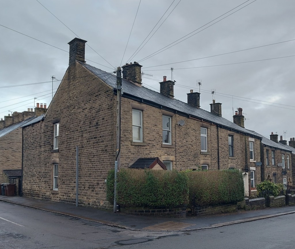
No’s 116 to 122 make a small terrace of four stone-built houses, typically mid-late Victorian in shape, and are much like all the others around them.
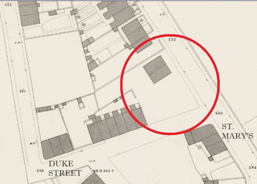
The corner of Duke Street and St Mary’s Road.
They don’t appear on the 1880 1:500 OS Town Plan
The lack of houses is circled in red, with St Mary’s running broadly NW-SE. Map stolen, as usual, without shame, from the enormously useful and always fascinating National Library of Scotland OS map database. Check it out here.
But they do appear on the 1898 25 inches to the mile OS map:
You can really see the map filling up, and a real sense that Glossop is still filling out to its Victorian and early 20th century maximum. Map stolen as per above!
Which gives us a date of between 1880 and 1898 for their construction.
So about the name, then. It took me a moment or two to see them, but at the end of each of the corbels that hold up the guttering, you can see a letter or character.
Apologies for the darkness of these photographs… I didn’t realise quite how murky they were until they
Wow! I love this, and I cursed myself for not noticing them before – serves me right for always having both eyes on the floor! It is difficult to photograph these without a telephoto lens, but also without attracting the ire of householders, who oddly don’t like it when you stand around taking photos of their houses, usually muttering threats of ‘setting the dogs on you’; people are strange. Anyway, the best I could do is the following stream of photographs; apologies in advance!
J O H N+ T R UE M A N .
So then, what do we have?
J O H N + T R U E M A N 0
Nice! A mystery. There is very little relevant online, but there was a reference to a John Trueman as the publican of the Beehive Inn in Whitfield, which was worth following up, and hence the History in a Pint Pot advert. The connection is not immediately obvious, but the fact that Trueman was mentioned as both wine and spirit merchant, and a stone dealer in the advert suggests that he built the houses, and probably using his own stone. It seems that the position of publican of The Beehive (or ‘Bee Hive’, as it was then) came with the rights to the quarries at the end of the track beside the pub, next to Fieldhead Farm there.
The Beehive is arrowed in red, but you can see the track leading to the quarries at the end.
William Miller, the landlord in 1857, is also described as a stone dealer. Our man John Trueman was landlord here between 1871 and 1894, which is also spot on for the date of the houses. I like the idea of him wheeling and dealing, serving pints and stone in equal measure. And if you build houses, then why not go ahead and sign them, particularly in a rather cool way. There seemed to be a lot of that around at the time, and as I was walking away from St Mary’s, I remembered another named building that I’d like to take a look at – Norfolk Buildings on Victoria Street:
Norfolk Buildings and The Surrey Arms
According to Robert Hamnett, The Surrey Arms and the three adjacent houses in the terrace were built in 1846 by James Robinson, who owned a large number of houses (and presumably having built them, too). You can see the uniform design and decoration of these three, especially in comparison with those buildings to the left, which are smaller and built to a different design. You can also see the ‘join’ between the two groups. It seems that these houses were constructed later that Norfolk Buildings, and presumably by a different person – again evidence of the piecemeal process that characterised Glossop’s Victorian building boom. The name/datestone is above the centre of the three houses:
I wonder if ‘archaeologist‘ would hold up in court as a defence against being accused of being a ‘peeping tom’. An academic question, obviously… purely theoretical.
‘J.R. NORFOLK BUILDINGS 1847’
The ‘J.R.’ is presumably James Robinson, and the buildings named after the Duke of Norfolk, whose investment in the town was arguably at it’s greatest in the mid-19th century. The date speaks for itself, though Hamnett notes that the lease for the pub dates from 28th March 1846, so this might be a lease connected with the land itself, or perhaps the proposed pub.
So there it is, this month’s offering… and I made it in January! There are so many Victorian datestones in the Glossop area, many recording details beyond just a date, and we find house names, builder’s names, area names, and the like. I’d like to do another survey of datestones or name plaques for the Victorian period, to accompany the one I did (and is still ongoing) for the pre-Victorian period. Or, you know, convince one of you to do it and publish it on the website (if you fancy the challenge, give me a message). Anyway, more again very soon.
In other news, the first issue of Where/When is back in stock. So, if you fancy a guided Wander from the Friendship Inn to The Oakwood, via Ashes, Dinting, Adderley Place, Pikes Lane and Harehills, and through the prehistoric, Roman, and medieval periods, then this is the publication for you… especially if you like what you read here!
You can download a free copy here, but there’s nowt like a physical paper copy: £5 from Dark Peak Books, on High Street West on Glossop (and I might be the one to serve you!), or you could just ask me, and I’ll bung one to you. For those that have been asking, Issue 2 is on the way… and honestly a fantastic one it’s going to be.
I’ve also got a few actual different Wanders planned, real actual physical walks led by yours truly, up hill and down dale, and through our amazing shared historical landscape. You can even throw stones at me when I start to bore you about pottery… and no, that doesn’t mean you can sign up for it just to lob rocks at me, Mr Shouty-Outy. Anyway, watch this space as I’ll advertise it her, and elsewhere.
So that’s about it for now. Hopefully I’ll get a couple written for February – I have so many half-finished articles it’s ridiculous, and I just need to get on with it (lots of pottery goodness!). But until then, look after yourselves and each other, and I remain.
What ho, and, if I might say, a happy new year to you all!
A somewhat chaotic mixed bag this week as its essentially a series of updates of previous posts. But fear not gentle readers, there is pottery here, too. Oh yes, don’t you worry about that. On with the show, then…
A SPOON
A while back I received a strange gift in the form of a spoon left on the wall outside my house. I blogged about it here, but here is a reminder:
Wow, it was sunny day when I took this photograph
I noted that the numbers might have been a way to prevent the theft of the spoon from the Beehive pub. Well now, that’s clearly nonsense, and I have been something of a blockhead (I said “blockhead“, thank you very much), and it took the wonderful Sandra T to point out what should have been obvious – they are military identification numbers, corresponding to an individual soldier.
So I did a little digging (a poor pun, fully intended… please accept my apologies), and indeed it is a WWI military issued spoon. The makers – Walker and Hall of Sheffield – and the spoon design, both check out; millions of this type and design were issued to soldiers, made by a variety of manufacturers. The date of roughly 1880-1920 similarly checks out. Now, the markings. It should be noted that there is no ‘Broad Arrow‘ mark on the spoon, which is something that was put on anything related to the military. This is unusual, but not unknown – an individual spoon maker, hand stamping thousands of these things a day, is bound to make a mistake or two – or it may well have been a replacement spoon for one our man lost. The Service Number is the interesting part, as it could potentially identify the man himself – a name to a spoon, so to speak – and give us a little history. Alas, they are jumbled, with some seemingly upside down, and so far I have not been able to identify the person that used them. They seem to read:
I may be wrong, and please, feel free to have a look yourselves – I’d love to give a name to the owner.
One final aspect of the spoon convinces me that this it is a WWI issued: the shape of the bowl. I had thought that the lob-sided nature indicated use-wear by a right handed person, but according to this forum, inhabited by all sorts of experts, it was deliberately done by many soldiers in order to enable the standard rounded spoon reach the more square corners of a mess tin. So there you go.
As to why it was in a wall… I don’t know. It may simply have been mischievous or bored activity – pointless and mindless, but something we have all done. But it feels more purposeful, and I am reminded of the blacksmith in the village of Catwick in Yorkshire, who nailed to the doorpost of his forge coins given to him by the 30 soldiers from the village going off to war, all arranged around a horseshoe. The coins represented each of the soldiers, leaving a little of themselves in their rural home, and the horseshoe luck. This can be considered an act of sympathetic magic, however half-hearted or jokingly done, conjured by a blacksmith, an individual who folklore already imbues with magical power. Interestingly, Catwick is one of only 53 villages in England known as ‘Thankful Villages‘ in that every man who went off to war, came back alive. Perhaps the magic worked? Was our spoon perhaps placed in the wall by our man as a way of leaving something of him behind, in order that he would return unharmed? And if so, did it work I wonder? I hope it did.
DATESTONES
So, the great datestone list has expanded… by three for Whitfield, and several more for surrounding areas. I’ll stick with Whitfield for now, though.
Pikes Farm, Pikes Lane.
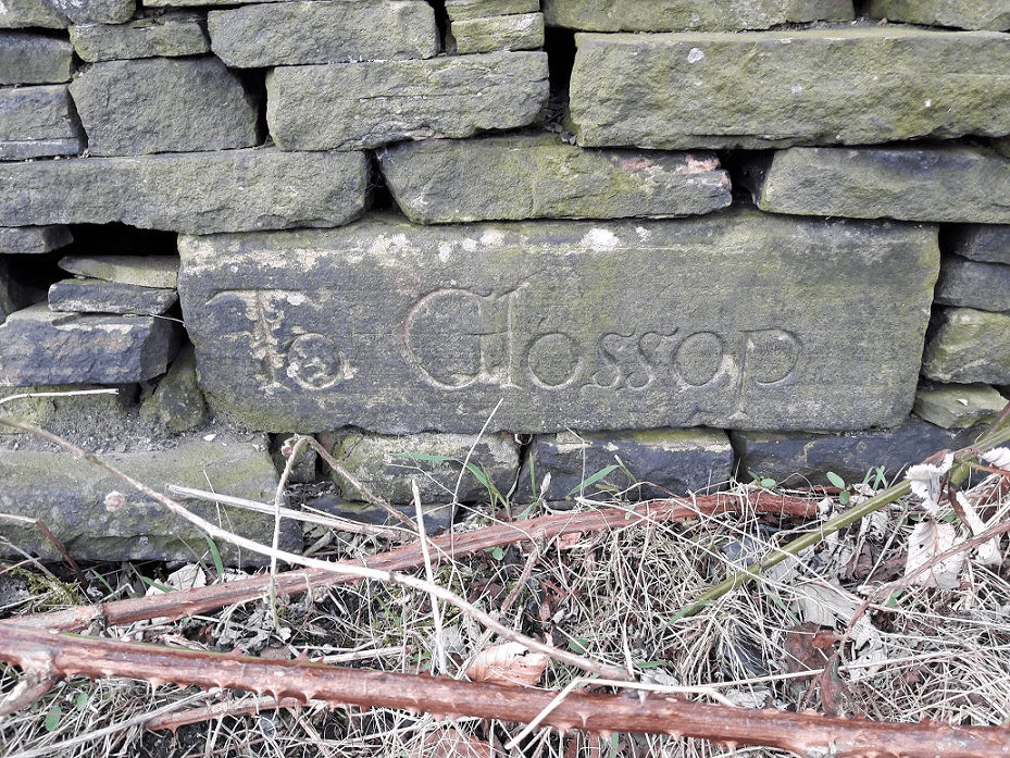
Pikes Farm, then. A date of 1780, and the intitials S. W. which, according to the original Robert Hamnett, belong to Samuel Wagstaff. And who are we to argue with that. I like the flourish with which the ‘8’ has been carved, not completed so that it looks almost like an ‘S’. Pikes Farm is interesting; it sits on the line of the Roman Road from the fort of Navio at Brough, near Castleton, and was connected by trackway to Dinting and Simmondley. It is such a prime location that I find it difficult to believe that people waited until 1780 to build a farmhouse there, and I suspect the location is a lot older.
Alas, no photograph. It is set far off the road, and although I tried, my phone’s zoom is not great. And strangely, people take a dim view of random Herberts wandering over their land and taking photographs. So instead, like any other sane and normal person, I sat in the car on the road and, using binoculars, I drew the datestone (…and that, Your Honour, is what I was doing when police Constable Jones wandered over.) . The date is 1772, the letters are R S M W – perhaps Robinson? Not sure, and Mr Hamnett can’t help us here, alas.
This next datestone illustrates why caution is sometimes needed in using datestones
The date of 1657
Whitfield Barn is on Cross Cliffe, the old trackway. As the name suggests it is a converted barn with probable farm house attached (another example of a ‘laithhouse’, that is a building made up of a house, barn, and byre/shippon in one). The stone is modern, and whilst the building is old (1750 – 1800, say), it doesn’t look like one built in the mid 17th century. Now, I’m not suggesting anything is incorrect, and it is likely that the building has a core that is of that date, and that the owners simply had a stone carved to reflect that. Indeed, if you look closely, you can see a number of different building phases. In particular just below the roof, where the upper floor has been raised, you can see the original roof line marked out in a line of stone.
Whitfield Barn, Cross Cliffe.
However, what if the owners were incorrect and mis-read an old deed? Or worse, anyone can commission a stone to be carved with any date they fancy. I’m certainly not saying that this is the case here, just using it to illustrate that there can be problems if we rely on a stone for a face value date. However, if we take that date as legitimate (which I am sure it is), then it provides us with a handy terminus ante quem for the track – the track goes past the house not to it, which implies the house was built after the track, so the track must already have been there in 1657.
I think these local tracks are largely medieval in date, and form a network that enabled people to move between the settlements that made up the Glossop dispersed settlement. And as time went on, more land was freed up, and new farmsteads sprang up along these routes. Thus, along this trackway that starts in Whitfield at the bottom of Cliffe Road, we see Whitfield Barn, Carr House, White House (with a side track taking in Jumble and Lower Jumble Farms). And, it follows, if we know where the original destination was, we can suggest an early date for that. The answer here is The Hurst on Derbyshire Level. Hurst is from the Anglo Saxon Hyrst, meaning ‘wooded hillock’, and which probably describes the hill immediately south-east of The Hurst. It is first mentioned as Whytfylde Hurse in the Feet of Fines in 1550, but an earlier date might be suggested by the rounded or ‘lobate’ shape of surrounding fields, indicative possibly of assarting (the process of converting forest into arable land), and what, to this untrained eye, looks very like ridge and furrow in the fields surrounding it. Both of these are largely medieval practices, and together could be quite telling. Hmmmmmm… I think The Hurst area needs a bit more looking into!
A CARVED CROSS
I blogged about a mystery white stone with a cross carved on it ages ago. I suspect that it (the stone, not the cross) is to protect the house from horse-drawn traffic, but why it has a cross on it, I still have no idea. Some months ago, though, I was sitting having a pint at the Beehive waiting to meet Mrs C-G, and vaguely staring at the wall ahead of me (I do love a nice bit of old walling!) when suddenly this came into focus:
The cross, worn, but definitely carved. As seen from the benches outside the Beehive. Cheers!
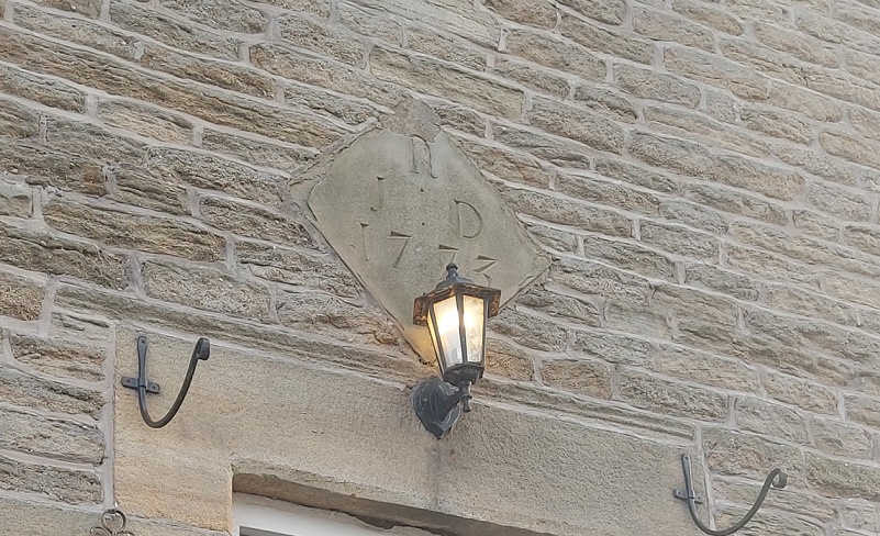
Given that it is on the same road, not 100 yards from the white stone, and carved in the same rough but deliberate way, it surely can’t be a coincidence… can it? The house on which it is carved – 61 Hague Street – also has a datestone of 1773, which provides us with a niceterminus post quem (the opposite of a terminus ante quem – a date after which it must have happened) – it can’t have been carved before 1773 as the building didn’t exist.
Nope, it’s all a bit strange, but I love a mystery.
And finally… yup, you guessed it. Drum roll please…
SOME POTTERY… BUT NOT LOTS!
A single sherd found between the setts of Bank Lane, Tintwistle, right by Bottoms Reservoir.
The sherd in-situ, nestled between the setts.
Nothing too interesting. I mean it’s a nice sherd of Transfer Printed Ware – probably a bowl, as it has flowers printed on the interior and the exterior.
Late Victorian pale blue & white. More delicate than the usual harsh blue stuff.
It is also unlikely to have been dropped in the last 100 years or so, and has thus laid there, between the cracks, just waiting for a dashing young(ish) and handsomely moustachioed archaeologist to find it. I was going to make this a full on pottery post, but it’s already too long, so the pottery will have to be next week, or so. I know, I know, but good things come to those who wait. And whoever is crying and yelling “no, no, dear lord please not next time” – you must try and control your excitement.
A TINTWISTLIAN TRACKWAY
However, back on track, and it’s Bank Lane that proves the focus, the sherd was just a way of getting onto the subject! This is a really interesting trackway, and is one of the two original (probably medieval) ways into Tintwistle from Hadfield, and before the Woodhead Pass bisected it (this stretch was made and improved in 1844 – look at that, another terminus ante quem!), it would have linked up with Bank Brow to get to the heart of the village. Incidentally, the other trackway goes via Lambgates, Roughfield, under the reservoir, and enters at the east of Tintwistle).
So, Bank Lane then. It curves up, and just before it reaches the Woodhead Road, it runs below the retaining wall of Christ Church, Tintwistle.
A nice bit of walling, that.
As I said above, I do love a nice old wall, and I’m always aware that there might be interesting details hidden in them… and so it proved to be the case here. Firstly, I spotted this date:
Rather fancily carved, and definitely not the product of my imagination!
I think it reads 1841. Now Christ Church was built in 1837, is it possible that the wall was put in place 4 years later, perhaps replacing an older one? On balance, I think yes, but a quick rummage through the church records might reveal some detail.
And then I noticed this:
Is it? I think yes, but I might be just seeing too much into it.
I am fairly certain that this is a set of initials, carved messily but cursively into the stone. I have made an attempt to outline what I think they are, but honestly it is entirely possible that I am just seeing things. I’ll let you, dear and gentle reader, decide for yourselves.
I mean… perhaps?
Possibly it reads ‘J. B’. Possibly?
And finally, another carved cross. This one looks more modern, and perhaps is a mark for where some utility is under the road? Not sure.
Possibly interesting?
Anyway, Bank Lane deserves a closer look. I have a whole ongoing project that is looking at these ‘original’ trackways that linked all the farmsteads in the area, as many are still preserved. It’s way more than a single blog post, but I’d like to do a series – examining each trackway, photographing it, marking it on the map, and recording any finds. Oooooh, that sounds exciting, I know.
Finally…
WHITFIELD GUIDE STOOP
I have blogged about the guide stoop several times before, as it’s a vital part of the history of the area, and presents something of a mystery – please read here and here for the full lowdown.
The guide stoop.
At the start of lockdown, I went on a walk past the guidestoop, and was horrified. Someone had had some work done in their back garden which required the rebuilding of the back wall and the removal of a large amount of soil. Whoever was doing this work had spread the soil along the track, at the bottom of the wall, and had completely buried the guide stoop in 2ft of earth. I mean, benefit of the doubt, they might not have noticed it. Here’s what it looks like currently:
Under here, somewhere.
If they did see it, however, then they were morons, and I just hope they kept the guide stoop in position, and didn’t steal it. Now, I haven’t re-excavated it yet for two reasons. Firstly, it’s a lot of earth, and a lot of brambles! And secondly, I’m not entirely certain where the guide stoop actually is under all that! all my photographs are of it in closeup, rather than a long view that gives a location in relation to the upper part of the wall. So, I have a favour to ask. Well, two actually. Firstly, does anyone have a long view that shows the top of the wall and the guide stone they could let me see? And secondly, does anyone fancy meeting up with a shovel, so we can dig the thing out and once again have back it on display? It shouldn’t be too much of a job. Anyway, drop me a line if you fancy volunteering.
Right, after that mammoth post, I’m going for a lie down! I will post the pottery in the next week or so – it’s largely written, and the photographs are ready to go, so it won’t take long… I can feel the wave of excitement from here.
Until then, look after yourselves, and each other. And I remain,
(And apologies to those of you who have ended up on this website expecting to find an informative article on the seed of the Phoenix dactylifera.)
What ho, magnificent readers! I trust you are all rude health as we stumble toward the season of goodwill and whatnot. I love this time of year, when the cold wind blows, and the… What’s that? What do you mean “get on with it!”. Honestly, the nerve of some people.
Righty ho. Datestones. Who doesn’t love a good datestone? I mean, what’s not to love? A little snapshot of the history of a building, a birth certificate if you will, recording both the date of birth, and, if we’re lucky, the parents too.
Normally, though not exclusively, located above the door, these carved stones preserve the date of construction and the initials of the person or family who paid for its construction. The are by and large the reserve of the aspirational ‘middle classes’ of society; the poor man doesn’t build his house, the rich man has a house that speaks for itself. Indeed, it is a statement to others: I have wealth enough to build this house. They seem to become popular in the 17th century, as the ‘yeoman farmer’ becomes a class of person, that is, a person who owns the land they farm. Indeed, it may be a result of that phenomena, a way of setting themselves apart from the simple tenant farmer, who doesn’t own the land he works. Glossop has several 17th century examples remaining, though many more will have been lost, sadly. They do show up, occasionally, as the one found by Glossop Brook at Harehills Park did, and which was saved and cemented into the brook wall. Interestingly, this example also shows that whilst datestones can be a boon to historians, they can also present problems if we are not careful. They can move easily, and be attached to other buildings giving a misleading date, as is the case there, and at Hall Fold Farm. Also, stones can be put in place to commemorate a rebuilding or alteration to an existing building, causing similar, if opposite, problems.
By the Victorian period it was common to put a date and/or name on a house you built, and a careful look at many rows of Victorian terraces around Glossop will reveal names and dates. With that in mind, I have restricted my research to those datestones that carry a date prior to Victoria’s reign, pre-1837. The following is a table of the ones I know about:
There are 28 datestones in the Glossop area (broadly defined), but there will be more lurking that I don’t know about, either attached to the building still, or lying in a garden. This blog post will concentrate on the examples from Whitfield, as it is turning into a much larger post than I had thought. Plus, in the interests of honesty and transparency… I haven’t got photographs of all of them yet!
Whitfield has some of the oldest buildings in the Glossop area, and although not really much of a ‘place’ now – essentially just a ‘suburb’ of Glossop – it was once hugely important, being built along the Chapel en le Frith to Glossop road. It gradually lost it’s importance with the rise of the mills based down in the valley, the economy here being agricultural. Whitfield’s one-time importance means that we find many old buildings and a number of datestones here. Indeed, Whitfield has more old buildings that Old Glossop, which with its Church and market, was the focus of the farmsteads and settlements of Glossodale. However, important places tend to be subject to more intense rebuilding over time, whereas more minor areas maintain their old buildings. I was going to do a distribution map of the old buildings, but changed my mind for that reason. Still, it’s worth noting that Whitfield underwent a bit of a building boom in the mid to late 18th century.
35 Whitfield Cross.
35 Whitfield Cross was built in 1773 as a farmhouse, and is a Grade II listed building – see here for more details. The narrow coursed stonework and stone mullioned windows are typical of the period.
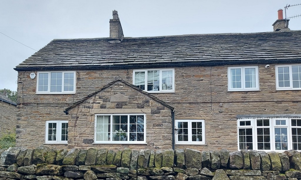
61 Hague Street.
61 Hague Street was also built in 1773, but as a pair of weaver’s cottages, and is also a Grade II listed building. 1773 must have been busy year, and Whitfield was clearly a happening place in the late 18th century. The datestone records the initials R. J. and D. Now, presumably the ‘R’ is the surname (possibly Robinson – the family being quite prominent in Whitfield) with ‘J’ and ‘D’ being the husband and wife who are responsible for the building. I have no information regarding the people, sadly, and any information would be appreciated.
Hob Hill Cottage
Hob Hill Cottage is a remarkable building dating to 1638, making it the second oldest building with a datestone in the Glossop area (after the Bulls Head in Old Glossop, dated 1607). Also built as a farmhouse, and also a Grade II listed building (there’s a theme developing here!), I suspect it might be the source of the lead came and glass, as well as some of the 18th century pottery, I found nearby, although truthfully any one of a number of buildings – existing or long gone – might be the source.
Old School House, Hague Street.
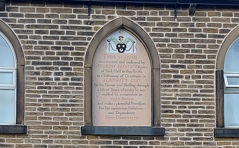
Another Grade II listed building now – the Old School House. Joseph Hague was something of an important man – indeed, the road on which the school (now private residences) sits is named after him. Born in Chunal in 1695, he rose from poverty to amass a fortune selling yarn to weavers and buying back the cloth they produced, to sell on. However, here is not the place for a discussion of his life, or of the school (the Glossop Heritage Trust does that very well here). Let us instead look at the wonderful inscription
“This school was erected and endowed by JOSEPH HAGUE Esquire, of Park Hall in this Parish as a testimony of Gratitude to ALMIGHTY GOD for his favour and Blessings through a life of years whereby he was enabled to accumulate an ample fortune and make a plentiful Provision for his numerous Relations and Dependents. Anno Domini 1779.”
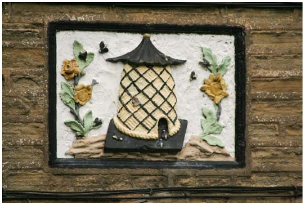
I enjoy the slightly boastful “ample fortune“… well, if you have it, why not? The beautiful carved relief plaque of the beehive over the main door – symbol of productivity and hard work – gave inspiration for the name of the pub over the road. The Beehive pub itself is an 18th century building, with a 19th century front added, and another example of the building boom of the 18th century in Whitfield.
Old School House, Hague Street. The beehive carved in relief, surrounded by Sunflowers, and crawling with characterful bees. I love this. 62 Hague Street
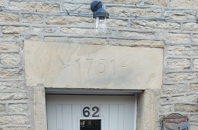
Another Grade II listed building, one of several together, and originally built as a ‘laithhouse’, that is a building made up of a house, barn and byre/shippon in one. It is a late example of the type if the date is to be taken at face value, but there you go… this corner of Derbyshire wasn’t exactly at the forefront of architectural fashion. There is also a bit of confusion regarding 62 Hague Street. As it stands now, there is a simple date of ‘1751′ above the door. However, the listing for the Grade II building notes that “No.62 originally had datestone inscribed RMS 1757” (read the full listing here). The present datestone is fairly modern, carved perhaps to replace the missing stone, but it doesn’t explain the difference in date. I thought it worth mentioning for the sake of documentation and completion.
41 – 51 Cliffe Road
So who was Joel Bennett? Born 11 April 1791 to son of George Bennett and Martha Cooper, he came from a large and important local family. He may have been the same Joel Bennet who was excommunicated from Littlemoor Independent Chapel in 1828 for “disorderly walking and impenitency” (source is here). I’m unsure of what is meant here by “disorderly walking”, but given the hotbed of radical religion that was Littlemoor, one assumes it wasn’t the Georgian equivalent of Monty Python’s Ministry of Silly Walks. He may also have bought Kinder Lee Mill in Chisworth with his brother James in 1823.
House at the bottom of Cliffe Road (4 Cross Cliff?)
This house, set back from Cross Cliffe almost at the bottom, has a wonderful datestone: stars, wheatsheaves, and a Masonic compass, with the letters ‘R’ ‘R’ ‘O’ and ‘S’. Actually, is that an ‘O’? Or perhaps a flower? I have no information about the place, nor the letters (Robinson again?), and one cannot simply knock on a door and say “What-ho… tell me about your house”. One tends to get stared at, with vague mutterings about “setting the dogs on you”, and “lunatics disturbing the peace”. Alas. If anyone has any information about this house, or indeed any of the houses, drop me a line.
Also, and seriously, if anyone knows of any more datestones that aren’t in the above list, and which date from before 1837, then please let me know. I’ll credit you, too, so you can be famous… to all 11 of you who read the blog (including Juan in Venezuela).
Oh, and some news. I’ve been working on the Glossop Cabinet YouTube account recently, and hopefully will be producing videos of me finding bits and pieces, mudlarking, talking archaeology, exploring, playing with pottery, and much more (can anyone else hear that groaning noise every time I mention pottery?). So if you like the blog, then you’ll love this. I’ll post a link asap.
Also, I’ve recently set up a Ko-Fi account which allows you lucky folk to ‘virtually’ buy me a drink if you wish. There is no pressure to do so, obviously; I do the blog because I enjoy doing it, and am constantly amazed that other people enjoy reading it (which is reward enough, it really is). However, if you do fancy buying me a pint to say cheers, I’ll never say no – please click this link, and mine’s a red.
That’s all for now I think. I’ll post something else before Christmas, possibly pottery related, you lucky lucky people (there’s that noise again). But until then, I remain,