What ho, delightful historical types (hysterical types?)! Welcome to a new article… don’t worry too much, it’s not pottery (I’m saving that for next time). Nope. This one looks at an interesting feature of Glossop’s personality. Buckle up!
So, some posts I can polish off in an evening (glass of stuff that cheers in hand, obviously). Others takes weeks to brew, and the process can be painfully slow. This one, though, is very different. I started writing it in August 2017… and it’s taken just under 8 years to publish it! No reason as such, it’s just I paused writing it, and moved onto something else, then I went back to it, and then did the same, and so on, and never quite finishing it. In fact, it’s so old, that it was written using an older version of WordPress (the platform I use for my website) which wasn’t really useable any more, and I had to paste the entire thing onto the newer version. Well, here we go.
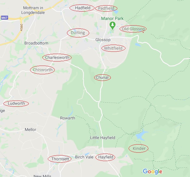
It’s often said that Glossop is a town of different areas, and with different character. When I first moved here, I realised that a lot of these areas were named ‘town’ – Howard Town, for example. On a simple level, ‘town‘ here refers to a collection of houses in an area rather than the traditional meaning of a large urban conurbation. I wonder of this is a local dialect, or perhaps more likely, Howard Town was named as such, and then the others followed suit, possibly ironically (Roughtown), or perhaps as a way of keeping in fashion (Milltown? Anway, this and is a which got me thinking… how many of these towns are there? And where are they all?
Well, in answer to these questions, may I present…
MILLTOWN
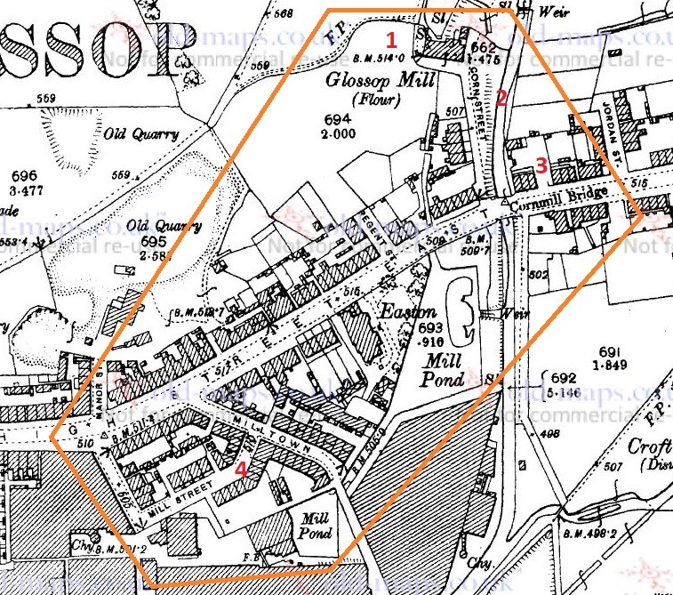
Despite its location, and seemingly obvious derivation, Milltown as an area has nothing to do with the Victorian mills, but instead it is so named because of its proximity to the medieval corn mill. Situated on what is now Corn Street, the mill was owned by the Lord of the Manor, and the people of the area paid to have their corn ground there – and nowhere else. It was, to all intents and purposes, a bit of a racket, but one that was universal throughout the land at the time. As you can see from the map below (and from photographs), there was a flour mill here in 1898, an 18th century building replacing an earlier one. It was demolished in the 1920’s, but you can still see the mill leat running alongside Corn Street. Also, the bridge over Shelf Brook as called Cornmill Bridge, which I did not know until just before I wrote these words… I love that!
Milltown marked in orange, to include the Corn Mill. In reality, Milltown is now just the area to the south of High Street East. On the map above, you can see the Corn Mill (1), Corn Street (2), and Cornmill Bridge (3). Milltown as a present day place is that to the south of High Street East, and comprising Milltown (the street) and Mill Street (4). The area has changed massively, but one constant is the Prince of Wales pub on the corner of those streets (I blogged about it here); pubs are often the only thing left after whole streets are demolished, as indeed is the case here.
LEAN TOWN
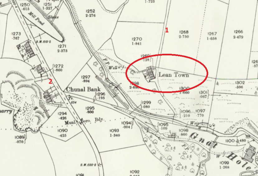
Lean Town is the name given to a group of four houses at the bottom of an apparently unnamed lane that runs from Hague Road to Gnat Hole. I can’t believe it is unnamed, but there you go… no map or document has so far given me a name! As you come from The Beehive toward Derbyshire Level, you pass a right hand downward track – follow this and eventually you hit Lean town. I wrote about Lean Town, here.
Lean Town. 1 is the track down from Derbyshire Level, 2 is Chunal.
The origin of the name ‘Lean Town’ is unclear; it might mean lean, as in not very rich, or poor for growing crops, or might be derived from ‘ling’, meaning the plant ‘heather‘ that grows around here.
CHARLESTOWN
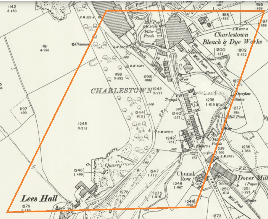
Once an area in its own right, it is now largely remembered in the name of Charlestown Road (and Charlestown Motors who I can heartily recommend, as it happens). It was named after Charles Hadfield who lived in Lees Hall in the late 18th century, and built the mill in Charlestown (now flats and houses).
Sort of this area, give or take. Charlestown Road runs from top down, and the PH (Public House) marked on the map is now Steak Land (replacing a firm favourite of mine, Casa d’Italia, although the word on the street is the Steak Land is amazing, so there’s that!)
ROUGHTOWN
Hope Street in Old Glossop was known as Roughtown, seemingly referring to the uncouth behaviour of its inhabitants, largely quarrymen from the nearby Glossop Low Quarries just up the road.
1 – Hope Street, 2 – The Greyhound pub, a factor in Roughtown’s reputation.
Apparently Roughtown was used as a semi-official name, with it appearing on census returns and trade directories of the time. Sticking with Old Glossop, we have…
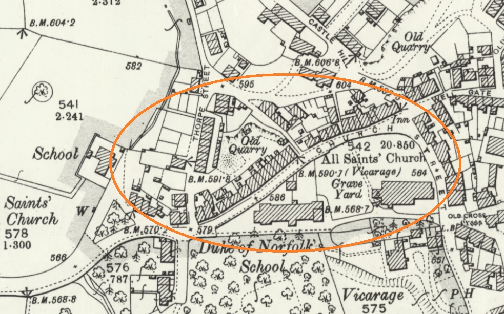
TOP O’ TH’ TOWN
The area between Thorp Street and Church Street in Old Glossop. It is, I suppose, quite literally the top of the town.
And the area at the end of Top o’ th’ Town is known as ‘Town End‘, which make sense. Over in Whitfield, however, we have…
FREETOWN
Stretches from the bottom of Whitfield Cross to the junction with Charlestown Road.
This sort of area, here. and particularly the road called Freetown.
Technically, and originally, Freetown was the name given to this area of Whitfield, with the name being derived from the fact that the land in this area, and subsequent houses built here, were freehold, as indeed it is still the case (my own house here included).
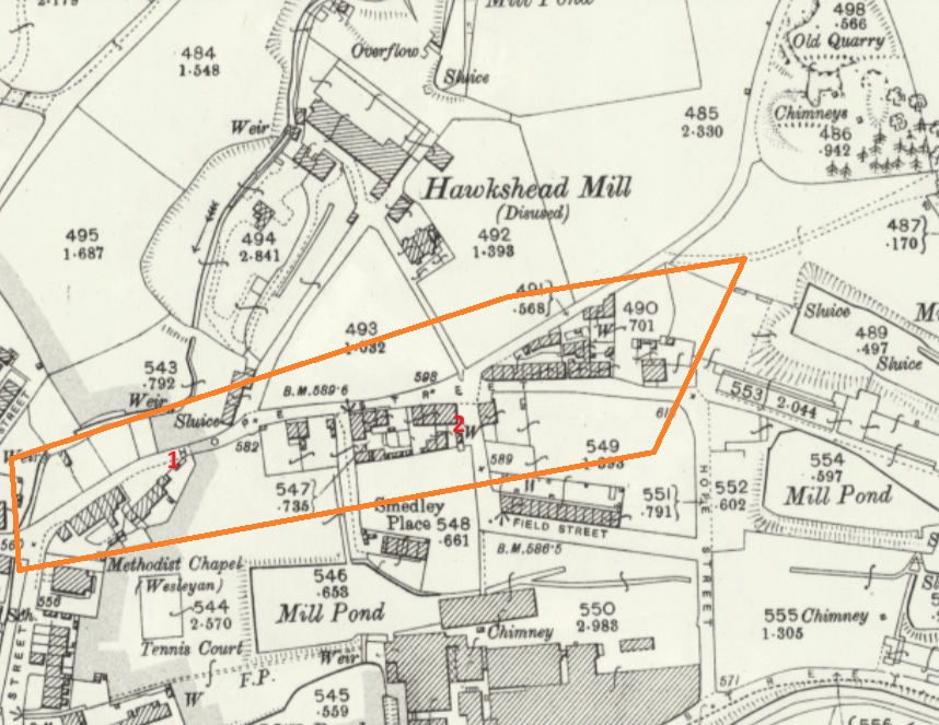
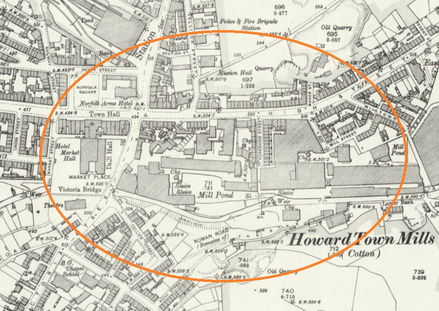
HOWARD TOWN
Essentially, what we understand as Glossop – the railway, Norfolk Square, the crossroads, and the whole area around the market and Wetherspoons.
Named after Bernard Edward Howard, 12th Duke of Norfolk (1765-1842) who invested heavily in Glossop – money and time. He built roads, the town hall, remodelled the whole area, and changed the focus of Glossop from what we now know as Old Glossop to what we now know as Glossop, but was originally Howard Town. This may have been the start of the ‘town’ naming process, as others followed suit, whether by flattery or through satire.
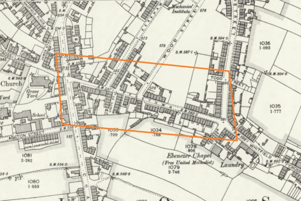
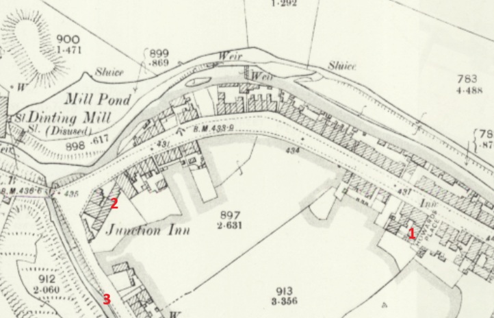
JERRYTOWN
A bit of an obscure one this – it’s mentioned by Hamnett as stretching along High Street West, from roughly The Grapes inn to the former Junction Inn and around.
1 – The Grapes, 2 – The former Junction Inn (now Simple Lettings), 3 – Primrose Lane.
Apparently named after a Jerry Sykes (1779 – 1856) who built a number of houses in this area in the 1820’s.
And there we have it! The many towns of Glossop town. I can already feel several of you desperate to tell me that I’ve got something wrong, or that I’ve missed a ‘town’ out. Please feel free to do so. Honestly, please let me know if I’ve messed up – I’d rather the information was correct.
I do have pottery for next time, and I owe you a new Rough Guide To Pottery – Part 11 unless I’m mistaken, you lucky people, you.
In other news, I’m doing a guided walk at the end of the month… which should be amazing.
Now that spring is coming I’m going to be walking the route of the Where/Whens so far published, and trying out some other new routes. Tickets for these will be available after the above walk has been done, and will be at the weekend, so everyone can take part – come and join us! Watch this space.
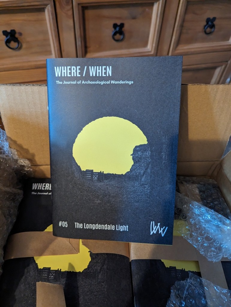
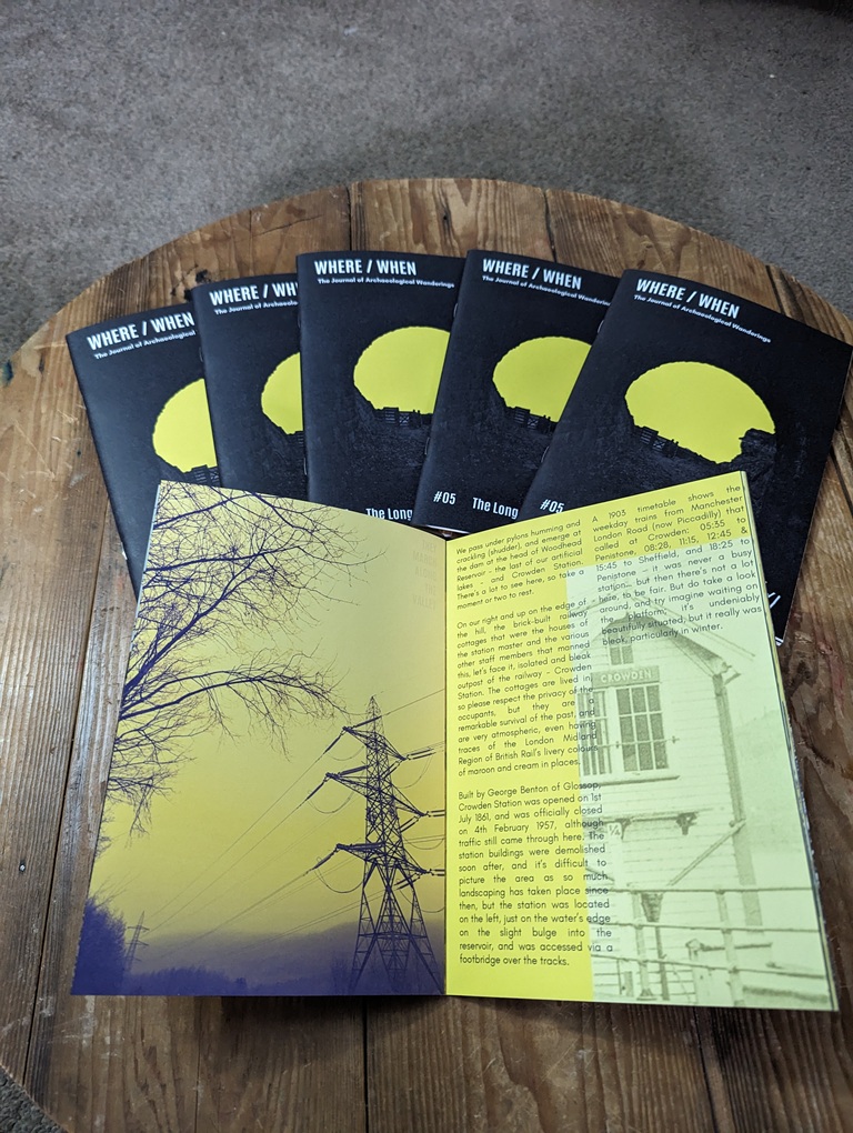
Talking of Where/When, No.5 has just been released.
An exploration of the history and archaeology of the Longdendale Trail, from the start at Hadfield to the tunnel entrances. Honestly, there is so much to see.
It’s available to buy from the usual places – Dark Peak Books, 96 High Street West, Glossop; the website’s store; or you can track me down and buy one.
I’m busy! Too busy, but it’s happening! I’ll post again soon, but until then, please look after yourselves, and each other, and I remain.
Ho! Ho! And if I might dare, What Ho! A shortish one today, and actually one that is something of a relief, if I’m honest. Like the last post, this one has been years in the making, but this time for all the wrong reasons… all will become clear in a moment, but for now let’s crack on.
As the title suggests boundaries are today’s topic, apt as we hurtle to the Winter Solstice and the shortest day – that anciently observed boundary between the old year and the new. Boundaries such as these are often held to be dangerous places as they are a liminal space – neither one thing nor another, but somewhere in between. However, boundary stones in particular I find fascinating and strangely appealing objects; there is something very grounding about them in that they mark in a clear, permanent, and fixed way, an imaginary line. On one side ‘X’ and on the other ‘Y’, and there is no argument – the somewhat liminal boundary is made visible and real, and so it is the case with our stones today – three stones placed on bridges over various waterways delineating the townships that make up Glossop
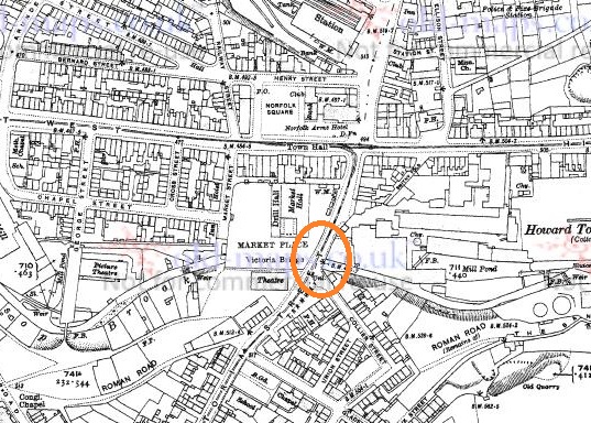
All three, it seems, were carved and installed at the same time, and all are quite old – early Victorian. The first of the stones is the easiest found – Victoria Bridge in the centre of Glossop.
Station at the top, above the High Street crossroads. The bridge over Glossop Brook, and the stone, is circled in orange. Glossop is north of the Brook, Whitfield is south.
And here it is in real life.
Victoria Bridge. Wetherspoons is in the background, and Glossop Brook runs beneath.
The bridge, and the stone, stand over Glossop Brook, which disappears under the market place and carpark, and the line carved between the words Glossop and Whitfield is the centre line of the brook below. Victoria Bridge was built in 1837, the year Queen Victoria ascended the throne, hence the name. This new bridge replaced an old and narrow hump-backed pack-saddle one. Indeed, the original line of the road that led over the bridge, down Smithy Fold, and along Ellison Street is traceable, and is preserved particularly in the buildings of the Brook Tavern, Cafeteria, Glossop Pizza, Balti Palace (all built in 1832). I have a blog post almost finished that looks at this area in more detail, so I won’t go into it here.
Looking closely, the inscription “Victoria Bridge” and the date “1837” are in a different font and slightly larger than the other lettering on the stone, and are more cramped, and it seems they were added at a later date. Indeed, compare this stone to the one below, and you can see they both once looked the same.
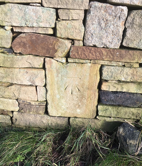
And of course, it wouldn’t be the Glossop Cabinet of Curiosities without a bench mark, this one on the bridge and just to the left of the boundary stone.
This is what 495.7 ft above sea level looks like.
The next stone is to be found on Charlestown Road, on a bridge over Long Clough Brook – it’s very much a blink and you’ll miss it kind of affair, even if you are walking.
Turnlee and Charlestown Roads join at the top, with the boundary stone circled in orange.Here is the bridge over Long Clough Brook on Charlestown Road. The stone is visible.Here it is in close-up. Can you spot a mistake?
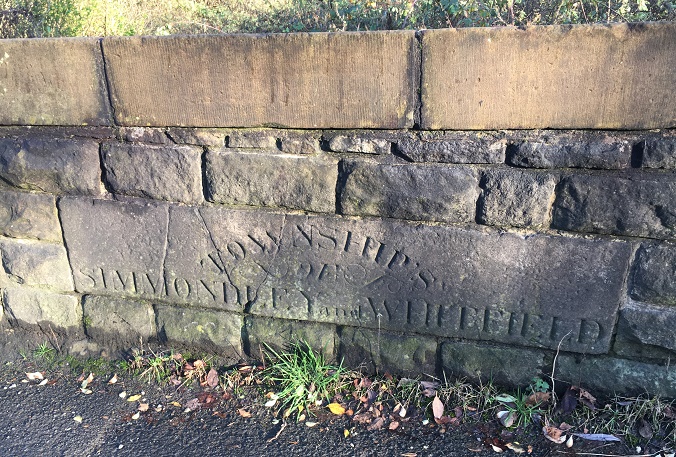
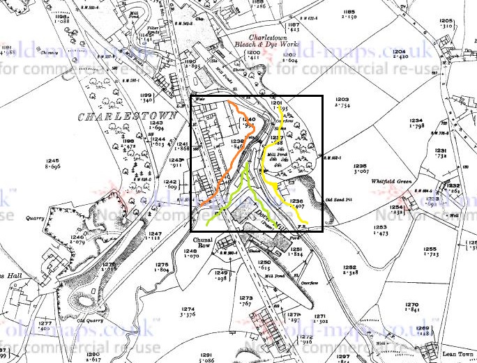
This stone follows the same formula as the Victoria Bridge stone, but is slightly rougher in execution. It seems to have been reset into a rebuilt stone wall at some stage, as it doesn’t really match the coarse surface of the stone around it, and this resetting might explain the cracking. It also has an inexcusable mistake… there’s a bloody apostrophe after ‘township’! It should read ‘TOWNSHIPS’, the plural of township, but instead it reads that ‘Township’ owns something called an ‘of Simmondley and Whitfield’! Also, although it states that this is the boundary between Simmondley and Whitfield, it technically isn’t. This is the border between Chunal and Simmondley, but it seems that for administrative purposes, Chunal and Whitfield were often lumped together. The confluence of Bray Clough (from Gnat Hole) and Long Clough Brook (just east of the boundary bridge) is actually the meeting of the three townships of Chunal, Simmondley, and Whitfield, here:
The three townships illustrated at the junction of Bray Clough Brook and Long Clough Brook. Chunal in green, Simmondley in red, and Whitfield in yellow.
So far, so good.
Now, the third and final stone was a bit more of a mystery. According to Neville Sharp (Glossop Remembered p.184 – a great book, by the way, well worth seeking out – here for example, but order it from Bay Tree Books on the High Street, of course), a stone similar to the one on Victoria Bridge stood on the bridge over Hurst Brook which forms the north eastern boundary between Glossop and Whitfield. That is until it was washed away in a flash flood.
High Street East at the top, with Derbyshire Level running from the Royal Oak off the map at the bottom. The word stone on the bridge over Hurst Brook is circled.
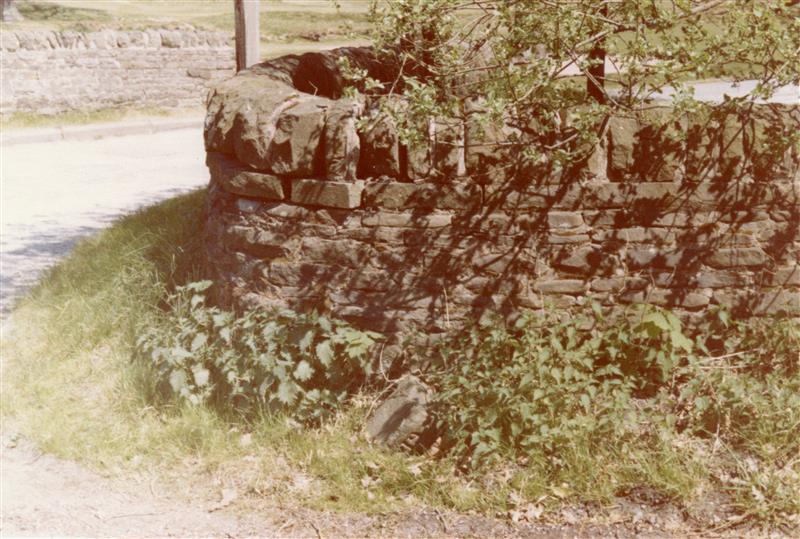
Then, whilst doing some research, I came across a reference to the stone and made a note in my notebook that until at least 1977 the stone stood next to the entrance to Golf Course. Annoyingly, I didn’t take down the reference and it’s taken me 3 years to track down the source of the information. Three years! Such is the level of detail and dedication I devote to this blog in order that you, gentle reader, can revel in such a fascinating subject as “bits of old plate” as it was once described by the person who runs the ‘Official Glossop‘ twitter account. Honestly, the nerve of some people…
So I re-found the source – this website – and blow me if it didn’t have a link to photographs of the stone taken in 1977:
Entrance to the golf course on Derbyshire Level, the boundary stone bottom centre, in the glorious sunshine of the summer of 1977
Close up of the boundary stone with part of the word ‘Glossop’ visible. Please note that I don’t have the copyright to these photographs, and make no claim to such, they are merely ‘borrowed’ from the above site.
The stone was presumably recovered, in its broken state, and set up on the side of the Golf Club entrance, and whilst it doesn’t look like there is a lot left I went to have a look.
The same view as the first photograph above, missing the important piece.
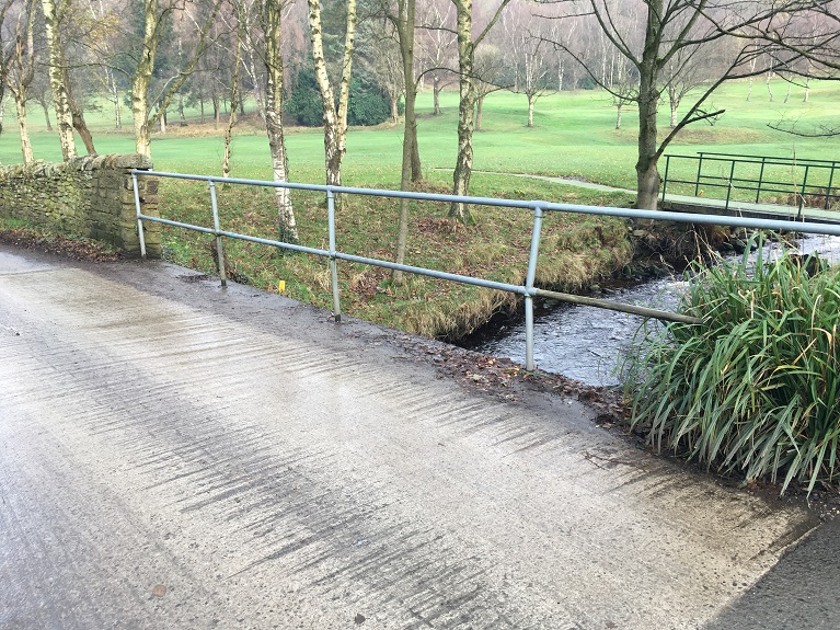
Alas… the stone is no longer there. I had a good look around at all the stones that might be a possibility, but to no avail. I suspect that someone has taken it – it was a nice piece of stone after all, but it is a shame. All is not negative, though, and from the 1977 photograph we might suggest where it originally stood; the fact that the fragmentary word ‘Glossop’ is visible at the left hand end of the stone means that it could only have stood at the eastern side of the bridge, closest the golf course, for it to make geographic sense – Glossop is north, Whitfield is south at this point. Here, in fact:
Here. You can see the modern(ish) bridge that must have replaced the one that was washed away. Here, Hurst Brook separates Whitfield (right) from Glossop (left).
Its fragmentary nature also suggests that more of it lies in the stream bed – I had a look, but couldn’t see any likely stones, but perhaps next summer I’ll have a poke around.
Right ho, that’s all for this time. Hope you enjoyed a ramble around the boundaries, and in fact I am writing a blog post that actually covers the boundaries of medieval Glossopdale based on a 13th century perambulation. I’d also like to do another that looks at the boundaries of all 10 townships of Glossop as they are in the Domesday Book, which could be a bit of fun. ‘Could‘ being the operative word here. And ‘fun‘ being an entirely subjective concept, I realise. But you, kind and gentle people, know what I mean… after all, you’re reading this. Please drop me any thoughts or hints, even to point out my mistakes, or the fact that I need a haircut. Take care of yourselves and each other, have a very merry Christmas, and until next time, I remain.
The thought occurred to me after publishing the previous blog post – what do the names of each of the manors of Longdendale mean? And I thought you, gentle reader, might also be interested.
I find placenames endlessly fascinating, and there is something magical about the origin of a name, whether traced back in the prehistoric period (‘Celtic’ placenames) or of a more recent coinage (Victoria Street, for example, named after Victoria Wood, of course…). Moreover, once you name a place it becomes familiar, and less scary, allowing you to find your place within, and manoeuvre your way through, the landscape. It is also a fundamental aspect of human behaviour: by naming the land, you are taming the land.
We have a huge number of influences in placenames in this area: Celtic, Saxon, Norse (Viking), Norman French, vernacular and slang English, and Welsh, to name a few. All of which mix together to create the landscape, and the places within, we know so well.
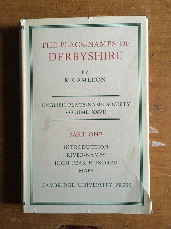
So then, using the 3 volume set of The Place-Names of Derbyshire by Kenneth Cameron, and some other sources, I set about finding out.
It may not appeal to everyone, but honestly this is absolutely fascinating book, if flawed due to the large number of placenames, field names, brook names, etc. that have been omitted.
Longdendale
First mentioned in Domesday Book of 1086 as Langedenedele, then Langdundale (1158), and Langdaladala (1161). This is a classic example of a tautology, caused by the naming of a place by someone who didn’t understand the original name. The origin is Lang Denu, ‘the long valley’, to which at some stage someone added the unnecessary ‘Dael‘, meaning ‘valley’ – thus Longdendale means ‘the long valley valley’.
Glossop
First mentioned in Domesday as ‘Glosop’. The Book of Fees of 1219 records it as ‘Glotsop’, and in 1285 it is given as Glosshope. Cameron gives the etymology as Glott’s Hop – Glott’s Valley – The valley (Hop – think Hope, as in Hope Valley) belonging to a man named Glott. Relatively straightforward then. Probably. Other theories are available. Mike Harding, the folk singer, thinks Glott should be read as ‘Gloat’, in which case it is the ‘Valley of the Gloater or Starer’, a reference to the numerous carved stone heads that were, and still are, relatively commonly found in the area (a subject of much debate, and a future blog post). This seems a little too convenient and smacks of mystical wishful thinking, but is still worth considering. It is also a possibility that ‘Glos’ is a derivation of the Welsh ‘Glwys’, meaning silver or grey, in which case it would mean ‘Valley of the Stream called Glwys”, which presumably would be Glossop Brook. Ultimately, I am going to go for Cameron’s ‘Glott’s Valley’ as I think it makes more sense.
Charlesworth
First recorded in 1086 in the Domesday Book as Cheuenwrde, then as Chavelesworth (1285), Chasseworth (1285), and Challesworth (1552). The meaning is either ‘Ceafl’s enclosure‘, the enclosure (worth) belonging to a person called Ceafl, or ‘Ceafl enclosure‘, which would mean ‘the enclosure near the ravine (ceafl)’. This might conceivably refer to the valley of the Etherow, particularly as it nears Broadbottom, but it is unclear. On balance, I prefer the simple ‘the enclosure (worth) belonging to a person called Ceafl’.
Chisworth
First recorded in 1086 in the Domesday Book as Chiswerde, then as Chisteworthe (1285), Chesseworth (1285), and Chesworth (1634). The meaning is simple – ‘Cissa’s enclosure’, the enclosure (worth) belonging to a person called Cissa.
Hayfield
First recorded in 1086 in the Domesday Book as Hedfelt (the same as that at Hadfield below), then Heyfeld (1285), Heathfeld (1577), and Magna Heyfeld (1584 – as opposed to Little Hayfield). Cameron discusses the possibility that there is some confusion regarding this name. In the Domesday Book the meaning is ‘Haed Feld’ – ‘heathy open land’, but the later, Middle English, forms seem to suggest ‘the field where hay is obtained’. Actually, I would suggest that two aren’t incompatible as land use may have changed over the course of 300 years – it is no longer heathy, and instead is more, well, hay-y.
Chunal
First recorded in 1086 in the Domesday Book as Ceohal, then as Chelhala in 1185, and Cholhal in 1309. The origin is Ceola Halh, which means either the ‘the neck of land belonging to a person called Ceola’ or ‘the neck of land by the ravine’. I personally favour the latter, with the ravine here being Long Clough Brook.
Whitfield
First recorded in 1086 in the Domesday Book at Witfelt, then as Wytfeld (1282), Whitefeld (1283) and Whytfelde (1294) in various Inquiries Post Mortem. It is also recorded as Qwytfeld in a land deed of 1424 pertaining to one John del Boure (Bower) of Qwytfeld. The meaning is ‘Hwit Feld‘ – open (figuratively ‘white’) land or field, presumably to differentiate it from the surrounding moorland.
Hadfield
Relatively straightforward, this one. First recorded in 1086 as Hetfelt, and later as Haddefeld (in 1185), Hadesfeld (in 1263), and Hettefeld (in 1331), it is derived from ‘Haed Feld’, meaning ‘heathy open land’ – literally, a heath field.
Padfield
Also relatively straightforward. It is first recorded in the Domesday book of 1086 as Padefeld, and in 1185 as Paddefeld. It means either the ‘open land (feld) belonging to a person called Padda‘, or an ‘open land where the toads live’, from the Old English ‘Padda‘ meaning toad. I like toads and frogs so I’m going with that, but you decide as you see fit.
Dinting
This one is more difficult. First recorded in the Domesday Book of 1086 as Dentinc, and then Dintyng in 1226, and Dontyng in 1285. It is also almost certainly the Dontingclought (Dinting Clough or Dinting Vale, as we now know it) mentioned in the Forest Proceedings of 1285. However, the meaning of this name is difficult to uncover. Cameron suggests that the first part of the word “Dint” is Celtic in origin, but can offer no meaning for the word. The second part ‘ing‘ is commonly encountered, but is complicated as it has many possibilities in its meaning. Here, it either means the ‘place of the Dint‘ (whatever Dint means), or it denotes an association of a person to the place or feature, so here it would be ‘Person X’s Dint‘ (again, whatever Dint means). The other (original… real) Robert Hamnett suggests that the name is made up of two elements – the Celtic word ‘Din‘ meaning ‘camp’, and the Norse ‘Ding‘, meaning ‘council’, thus it means the ‘council camp’, or a place where people meet to discuss law and other matters. Perhaps then we have our meaning – ‘the camp belonging to person x‘, or the ‘place of the camp‘. This latter may well be more likely, given that Dinting as we know it is at the foot of Mouselow Iron Age hillfort.
Kinder
This one is similarly difficult to pin down. First recorded as Chendre in the Domesday Book, then Kunder in 1299, Kynder and Kyndyr variously in the 13th and 14th centuries, and Chynder in 1555. Cameron suggests the name is “pre-English”, that is pre-Saxon and thus probably Celtic. He offer no explanation for its origin, as the “material is not adequate for any certain etymology”, alas. Still, the fact that the name is essentially Iron Age in origin is quite important.
Thornsett
First recorded in 1086 in the Domesday Book as Tornesete, then as Thorneshete (1285), Tharset (1577) and Thorsett (1695). The meaning is very straightforward – Thorn Tree Pasture.
Ludworth
First recorded in 1086 in the Domesday Book as Lodeuorth, then as Ludeworda (1185), Loddeworth (1285), and Luddeworthe (1330). The meaning is very simple – Luda’s Enclosure, the enclosure (worth) belonging to a person called Luda.
That concludes the 12 manors of Longdendale. However, I thought I’d also include Simmondley – even though it’s not one of the original 12, it is one of the towns that make up Glossop as we now know it. Plus, I know people who live there and don’t want them to feel left out.
Simmondley
First mentioned in the Forest Proceedings of 1285 as ‘Simundesleg‘, and then later as Simondeslee, the origin of the name is “the clearing (or ley/legh) in the forest belonging to a man named Sigemund or Sigmundr (an Old English or Scandinavian [Viking] name) – Sigemund’s Legh = Simmondley.
And there you have it.
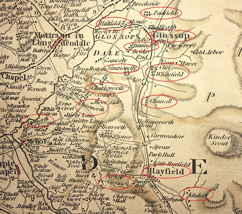
Here are the 13 (+1) placenames discussed above, illustrated here on a 1794 map.
Well that was fun! I’d like to do some more exploring of names the area; we have a rich tapestry of placenames in England, brought to us from hundreds of different sources, and recorded in countless documents, maps, letters, deeds, books, and memories, and this area seems to be richer than others. So if you enjoyed this, then watch this space. As always comments, questions, offers to buy me a drink, are all welcome.
Today’s post is one I have been meaning to do for a while – Glossop in the Domesday Book. I have been picking away at this one for a few months now, and finally I spent a bit of down time finishing it off. I must say I enjoyed writing it, and I really had to do some homework… which was fun. Hope you enjoy.
The ‘great survey’ of England (and parts of Wales) that would eventually become known as the Domesday Book was commissioned by William the Conquerer and completed in 1086. According to the Anglo Saxon Chronicle of c.1100, it was a survey of “How many hundreds of hides were in the shire, what land the king himself had, and what stock upon the land; or, what dues he ought to have by the year from the shire.“. In essence, what had William actually won in his new kingdom, and more importantly for him, how much he could make in taxes. I’m not a fan of old Billy, as you have probably guessed, and although Norman England brought with it some good, it also brought widescale changes throughout society – lay and secular – some of which were not particularly great. Academic argument rages, and will continue to do so, but I cannot forgive William the Bastard, as he was known (he was the illegitimate son of Robert I, Duke of Normandy, by his mistress Herleva), and even by the standards of his day he lived up to the other meaning of his name. But he did give us this unparalleled piece of historical evidence
The Domesday ‘Book’, now in 5 volumes at the National Archives in Kew.
Actually, the survey was undertaken and published in 2 parts – the ‘Little Domesday’, which covered Norfolk, Suffolk, and Essex, and the ‘Great Domesday’, which covered the rest of England and parts of Wales. Incidentally, the title Domesday Book, though not contemporary, is derived from the fact that the details recorded in it were as serious and as unmoving as the decisions made by God on the Day of Judgement – Doomsday. Also, as an interesting aside, my grandfather told me that he once had reason to be working at the Public Record Office in London, and that whilst there he found himself in the storeroom where the Domesday Book was then being kept. With a pound note pressed into his hand, the guard on duty opened up the high security box, and allowed my grandfather to place his own hand on the actual Domesday Book. But I digress…
So then, Glossop and area in the Domesday Book. The reference within the book is in Derbyshire, Chapter 1 (Land Belonging to the King), paragraph 30, and comes under the heading ‘Longdendale’.
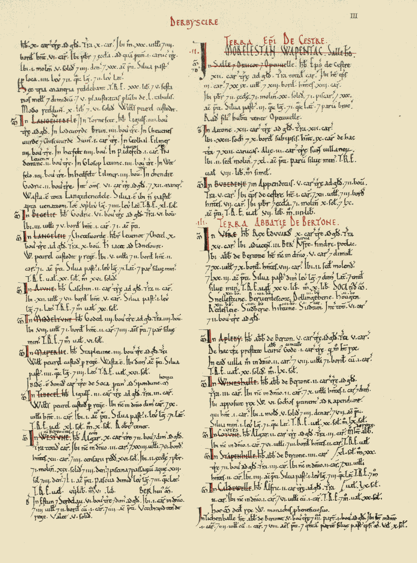
Here is the page:
The page from the book that contains Longdendale (top left)
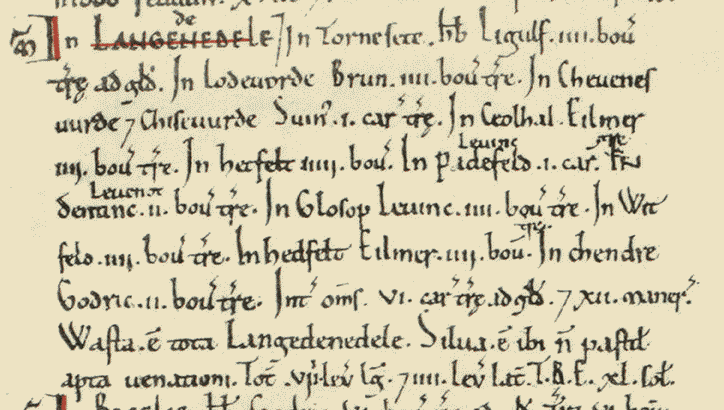
And here is Longdendale as it was recorded in the book:
Here we are in the nearly 1000 year old book. Quite remarkable.
The above image is courtesy of this phenomenal website which has digitised the whole Domesday Book, with all sorts of notes and details. Go and explore this fascinating document, and priceless item of English history.
I’ll give you the complete transcription, translate, and then discuss what it means.
In LANGEDENEDELE. In Tornesete. Hb. Ligulf. iiii bov. Tre ad Gld. In Lodeuorde, Brun. iiii bov. tre. In Cheuenesuurde Chiseuurde. Suin. i car. tre. In Ceolhal. Eilmer iiii bov. tre. In Hetfelt iiii bov. In Padefeld. Leofing i car. In Dentine. Leofnoth. ii bov. tre. In Glosop Leuine. iii. bov. tre. In Witfeld. iiii. bov. tre. In Hedfelt Eilmer. iiii. bov. tre. In Chendre. Godric. ii. bov. tre. Int. oms. vi. car. tre ad gld. Xii maner. Wasta. e tota Langedenedele. Silua. e ibi n pastit apta uenationi. Tot viii. leg lg. iiii. lev lat. T.R.E xl. sol.
In Thornsett (Tornesete), Ligulf had 4 bovates of land that were taxable.
In Ludworth (Lodeuorde), Brown (Brun) has 4 bovates of land that is taxable.
In Charlesworth (Cheuenesuurde) and Chisworth (Chiseuurde), Swein (Suin) has 1 carucate of land that is taxable.
In Chunal (Ceolhal), Aelmer (Eilmer) has 4 bovates of land that is taxable.
In Hadfield (Hetfelt), Aelmer (Eilmer) has 4 bovates of land that is taxable.
In Padfield (Padefeld), Leofing has 1 carucate of land that is taxable.
In Dinting (Dentine), Leofnoth has 2 bovates of land taxable.
In Glossop (Glosop), Leofing has 4 bovates of land that is taxable.
In Whitfield (Witfelt), Leofing has 4 bovates of land that is taxable.
In Hayfield (Hedfelt), Aelmer (Eilmer) has 4 bovates of land that is taxable.
In Kinder (Chendre), Godric has 2 bovates of land that is taxable.
Phew! Right… so what on earth does that mean? Well, Longdendale (Langedenedele as the book has it) is first broken down into areas, then who owns these areas is recorded, followed by the amount of land that is taxable – the Domesday book is essentially a tax record of how much William stood to gain from the invasion, after all. However, here, recorded for the first time ever, are the names of the places we know well. And I am struck immediately by how similar they are… stick a decent Glossop accent onto them, and they haven’t changed at all – Whitfield and Hadfield in particular! And I love the Saxon names, too. Aelmer and Leofing are the big landowners around here with 1 1/2 and 2 carucates of land respectively, and so are probably quite wealthy and with good lands. Poor Godric is stuck out in the wilds around Kinder, where it is difficult to see where his 2 bovates of taxable land could be located. Which brings us on to the next question… what the hell is a bovate? Or, for that matter, a carucate?
They are both ancient measurements of land area. A bovate (also known as an oxgang) is technically the amount of land a single ox could plough in a single season – somewhere around 15 acres depending on land and animal. However, a plough is normally driven by a team of 8 oxen, and the amount this team could plough in a single growing season is known as a carucate. Thus, a bovate is one 8th of a carucate. Now, I struggle to picture area, so the idea of a large area defined by how much work an animal does is, quite frankly, baffling.
Following the register of places and taxes, there is a general description of the area.
Between them 6 carucates of land is taxable, and 12 manors
Each of the 12 manors (the areas named above) would have had a manor house to go with it, and one wonders where they are. I have a few ideas, but there is no way of knowing without excavation. One can imagine Leofing, beer cup in hand, sitting on a chair in the centre of his house – effectively a large open hall in which multiple people ate, drank, slept and lived around a central fire pit, the smoke from which would have dissipated amongst the thatch or turf roof, as there were no chimneys in the 11th Century.
The 12 manors of Longdendale circled in red. Thanks to Google
Looking at the above map, I am struck by two things. Firstly, how almost all of the manors are situated on major roads (Whitfield is on the old road to Glossop, before it was diverted to what is now Glossop town centre), and how they are all still recognisable and distinct places. The one glaring exception is Kinder, which ceases to be a ‘place’ as such after the Medieval period; one presumes that it is in the area of the houses and farms on Kinder Road, but further research is needed.
Then there is the single word ‘Wasta’. Waste.
“All Longdendale is waste”.
Following the invasion of 1066, the North of the country – Cheshire, Derbyshire, Lancashire, Staffordshire, and Yorkshire – rebelled against the French king. William the Bastard chose to teach them a lesson over the winter of 1069-1070, and operated a ‘scorched earth’ policy of complete destruction of all villages, property, crops and people – the ‘Harrying of the North‘ as it is now known. There is some debate about the extent of the destruction, but there is no getting away from the fact that he utterly destroyed huge swathes of the North in revenge, and North Yorkshire in particular, with refugees from there mentioned as far away as Worcestershire. The effect was such that 16 years after the Harrying, Yorkshire had only 25% of the people and oxen that it had in 1066. The almost contemporary historian Ordericus Vitalis (basing it on contemporary descriptions) describes it thus:
“Nowhere else had William shown such cruelty… In his anger he commanded that all crops and herds, chattels and food of every kind should be brought together and burned to ashes with consuming fire, so that the whole region might be stripped of all means of sustenance. In consequence so serious a scarcity was felt in England, and so terrible a famine fell upon the humble and defenceless populace, that more than 100,000 Christian folk of both sexes, young and old, perished of hunger”
The word ‘Waste’ here in Longdendale is the result of this destruction – the valley, never particularly prosperous, or indeed populous, was laid waste… the Bastard burned the place to the ground. This is an astonishing fact, and that one word – waste – resonates. Indeed, as you read through the Domesday Book entries for the surrounding areas, the phrase crops up time after time “it is waste”.
Moving swiftly on.
Longdendale is then described as “woodland, unpastured, and fit for hunting” – which is better than some of the Trip Advisor reviews for places in Glossop – and the fact that it is “8 leagues long, and 4 leagues wide” (roughly 24 miles by 12 miles).
The entry in the Domesday Book finishes with letters “T.R.E. xl. sol.”. T.R.E. stands for ‘tempore Regis Edwardi’ – that is, in the time of the reign of Edward the Confessor, and refers to the worth of the land in the time immediately prior to the invasion. In 1066, Londendale’s worth (in terms of taxes) was 40 Shillings (represented in the book by the Roman numeral ‘XL’ for 40, and the abbreviation ‘sol’ for ‘solidus’ or shilling. 40 Shillings is not a lot, comparatively, and must surely represent the poor quality of arable land in these parts, as well as a lack of mineral resources.
Now, what is interesting, is what is left out. For example, there is no mention of people – freemen, villagers, smallholders, etc. – and we are left with the impression that there is no one here. Yet just over the hill, in Hope, we read that “30 villagers and 4 smallholders have 6 ploughs. A priest and a church to which belongs one carucate of land” and that “before 1066 these 3 manors paid £30, 5 1/2 sesters of honey, and 5 wagon loads of 50 lead sheets. They now pay £10 6s.” Clearly in Hope the invasion had had an effect – they now pay £20 less in tax, so one assumes there is less there now that is taxable – but there are people there, in 3 manors. So it seems odd, then, that Longdendale, despite having 12 manors, has no mention of people. It may be poor record taking by the surveyors, or it may be more sinister – Longdendale is the main route west out of Yorkshire, after all. The other oddity is that there is no mention of the church. It is possible that Glossop Parish Church is of Anglos Saxon origin, there is no evidence for this, and the lack of a mention in the Domesday Book is also quite telling. Which begs the question… where was the nearest church? Hope? That’s quite a journey to be made every Sunday, but I can’t think of anywhere else nearby.
So there we have it, Glossop’s debut in the historical record. One wonders where exactly Glossop was at the time – certainly not Howard Town, but perhaps Old Glossop. There is the suspicion that it may have been further out, toward Shittern Clough and Lightside along Doctor’s Gate, but again, we can’t be certain without excavation.
Anyway, I hope you enjoyed this little romp around Early Medieval Longdendale, As always, any comments, questions – or even abuse from pro-Norman activists – are all very welcome.
I love Lean Town – it’s a good walk from my house (even Master Hamnett can do it with the minimum of fuss… mostly), and yet feels oddly distant. The houses are beautiful, and I sometimes feel a tiny pang of jealousy as I pass, so it’s nice to finally do this blog post that has honestly been years in the making. Part 2 is the finds.
Lean Town from the bottom.
As you can see from the above photograph, the houses are perched on the edge of a steep slope. Now, in the Victorian period, there was no rubbish collection – all household waste that couldn’t be fed to livestock, burned in the fire, reused, repaired, sold for scrap, or spread on the food crops, had to be disposed of by the individual. Now, I’ve probably mentioned this before, but humans are essentially lazy creatures. Almost as a rule, they will take only two considerations into account when disposing of rubbish: 1) can I see it? 2) can I smell it?
With this in mind, you can usually tell where a waste dump – or midden – will be by studying the area and asking a simple question: where would I put the it to get it out of my sight and smell, but with the minimum amount of hassle? Houses, situated on a steep slope, hmmm… there’s only one place they would chuck it. Any thoughts?
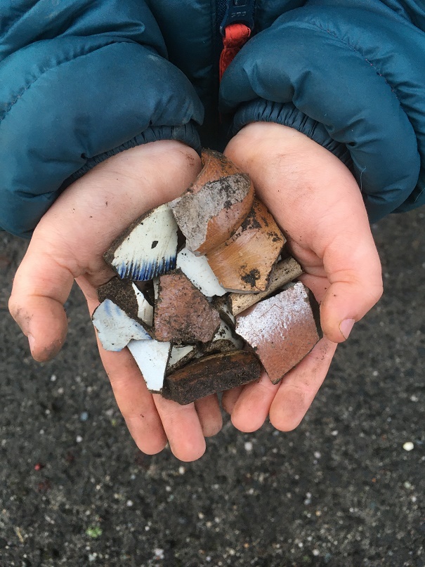
That’s right, well done, you guessed correctly and win a sherd of pottery (please email me with an address if you want it… I have many!). Over the back wall went the rubbish, and on the footpath below that wall went I. And by Jove, what a trove! This was all lying on the surface on the footpath that would have originally led from the houses to the well. Between myself and Master Hamnett we cleared out all we could see, but wait for the next rainfall, and more will pop up.
A proud parent! Master Hamnett was so excited to be picking the pottery up, stuffing it into his pocket, and walking along holding some in his hand. Like father like son…
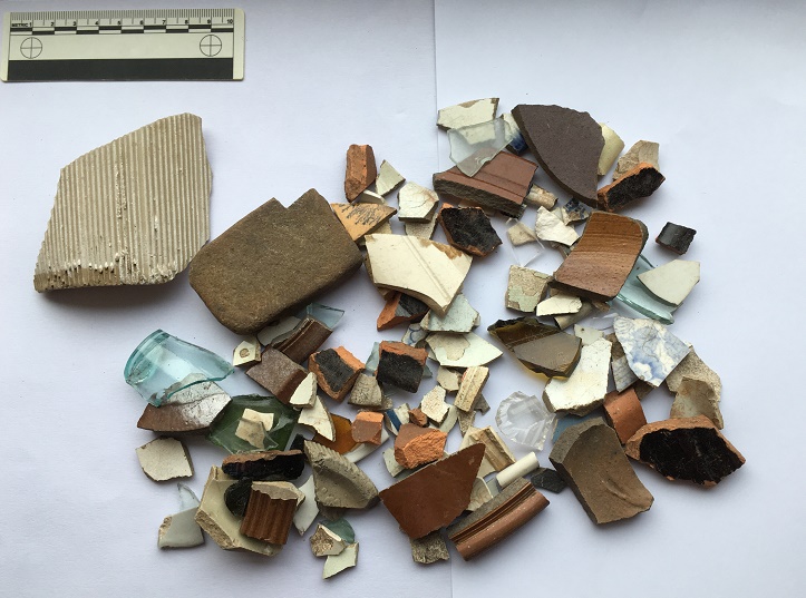
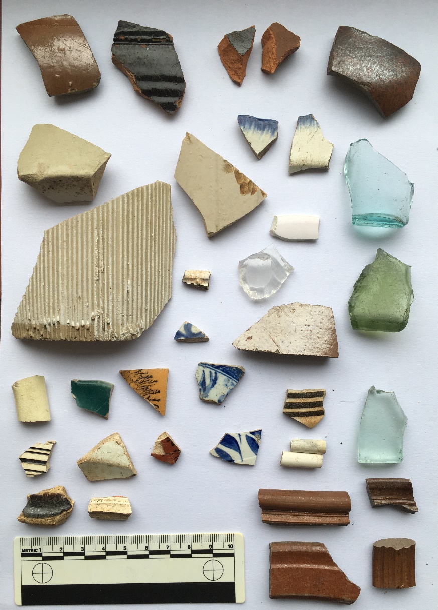
So, what did we get? The short answer is masses of early Victorian to Edwardian bits and pieces – woo hoo! I divided the slope area into two sections: one directly below the back wall of the houses, and one a little further west along the slope.
The assemblage from below the houses. Very impressive, and with some interesting bits in it.
The assemblage from further west, also impressive.
Truthfully, they are both rubbish dump areas from the same set of houses, but old archaeological habits die hard, and it is easier to keep them separate than it is to re-separate them if I needed to after joining the groups. In pottery analysis we call this “splitting” as opposed to “lumping” – once lumped, pottery is almost impossible to split.
I’m only going to discuss the ‘interesting’ sherds here – there is a lot of it (see pictures above), and life is too short. As a pottery specialist, I have a system that I follow when studying pottery, the short version of which is that I look at only ‘feature’ sherds (bases, rims, handles, and decorated sherds), and discount the rest (there is also a very much longer version, believe me… I can talk for hours about it).
So then, here we are with the interesting bits. First up, below the houses:
The interesting bits from directly below the houses.
Top row: glass side to a square sauce bottle – possibly HP sauce, but certainly very common in the Late Victorian period; one can’t help but think their food was quite bland. Upper rim is from an open bowl, possibly a cooking pot. It measures 20cm in diameter, and is glazed in what appears to be a slip-ware glaze, which puts it late 18th early 19th century. Lower rim is from a stoneware open bowl with a flat lip, measuring 24cm in diameter – probably a mixing or serving bowl, and mid-19th Century in date. Next to that, the top to a stoneware ink or beer bottle, mid to late 19th Century – I love this, aesthetically, it just so pleasing. Next to that a very fine impressed mug or tankard, 10cm in diameter, with purple glazed body. This is very delicate and fine, and the impressed pattern is lovely, it’s possibly Wedgwood, but if not it would nonetheless have been expensive – which makes me think.
On the left we have a large sherd from a pancheon (a large milk or mixing bowl), with the interior, rim, and upper exterior surface glazed. Here we can see the upper exterior, with the classic dripped surface, which, rather than it being the result of a mistake, is a deliberate decoration. This example is very interesting, as it has been given a manganese ‘mottled ware’ glaze, rather than the usual black, which makes me think this is an early example – mid to late 18th Century, I would say. You can see a more common black example next to it, complete with external drips. Sherds from pancheons are quite common, due in part to most people having one, but also to the fact that they are large (larger examples can be 60-70cm across), which means they produce many sherds when broken. The clay they are made from is always reddish-orange, with pale yellow or grey folds badly mixed into it – don’t ask me why, but it is always so.
Greyish yellow folds within the clay. Is it odd that I find that quite appetising? Actually, perhaps a more important question is should I have shared that information with you, gentle readers?
Above the black pancheon sherd is a sherd of our old friend the feather edged ware bowl. It is another rather nice pearlware vessel, measuring perhaps 20cm in diameter, and was probably a shallow bowl with a flat edge. I have recently done some research on this type, and suggest a date of 1800-1830 for when this was made, which fits perfectly. A quick archaeological aside: when made, and when thrown away are two very different things – I have some of my grandmother’s crockery which I still use, and which must be at least 70 years old. Heirlooms like this do crop up in archaeology, and can cause problems, but generally, I would suggest that 10 years is probably a good innings for an average plate or bowl, especially when you remember there were few carpets and a lot of stone flagged floors.
The green glass fragment has the letter ‘F’ impressed on it, and is late Victorian or later. Next to that is a base to a delicate pearlware eggcup, measuring 4cm. Again, this is quite nice, as is the pearlware base and rim next to it (rim diameter of 18cm so a small plate or soup bowl). There are some spongeware sherds, and some blue and white transfer printed bits, including a green example which quite frankly shows how crappy some of these mass produced pots are – if you look closely, this one has a broken transfer roughly fitted together before being glazed. Above this, there is a moulded base to another very fine 18th Century tankard or mug. Below that, there is a creamware moulded bowl rim, probably quite early (1790-1800?), and again probably quite expensive. Finally, we have a group of stoneware vessels – bowls, storage jars, and the like. These are fairly standard, with impressed decoration (flowers, rouletting, and undulating lines), and date to, well, the Victorian period – made continuously, they were very utilitarian and common.
Next…
The interesting bits from further west.
Top left, is a large, rounded stoneware bottle or closed shape of some sort – beer, perhaps? Certainly Victorian in date. Next to it is a black ware sherd, with an inscibed decorative band on the exterior, and dating to the late-18th and early 19th centuries. The shiny glaze is the result of lead being added. Far right on the top row is a salt-glazed stoneware sherd, again from bottle, and you can just make out where it forms into the neck. This is interesting, as it looks like it is a continental stoneware – imported gin, perhaps? Below that is a base fragment from a small sauce or syrup bottle – the glass is early, judging by the colour, so perhaps mid-Victorian, but do continue into the 1920’s. These are normally hand blown into a mould, and have a rough rim where it is cracked off the mouth piece – check out a good example here. Actually, the whole website What The Victorians Threw Away is an amazing resource – essentially run by another lunatic like me, if you like this blog, you will love that whole project… it’s basically what I would like to do if I had the time and money (donations always gratefully recieved!).
To the left of that is a pair of feather edge fragments, both on a pearl ware background, and both of the same age as the above example. Below these is a clear glass cup with a handle; it’s moulded not cut glass, but is nonetheless quite nice and fancy. Below and left of this is a sponge ware sherd, possibly from a plate, and probably dating to the 1850’s. Above that (ignoring the tiny sherd) is a large fragment of a stoneware jam jar, and to the left of that is a large stoneware storage jar. The base diameter of this is 20cm, which makes it a monster – possibly a cider flagon, or similar. What is interesting is that it has a lot of wear on the bottom, meaning that it has been taken off and on a shelf or floor many times, and suggesting that it was refilled.
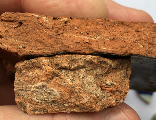
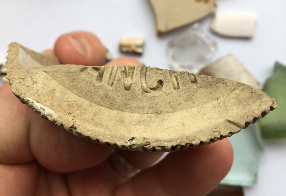
Below that is a large, roughly made, sherd from a large (2lb) stoneware jam jar, with the characteristic vertical fluting – once recognised, always seen! This has part of the base intact, with the words “ANCH” impressed into it.
I love it when I come across words. You can see clearly the stoneware fabric, and the glaze peeking through from the sides of the jar
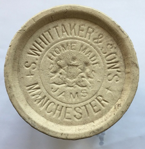
Unless it was ‘ANCHOVIES’, this could only be “MANCHESTER”, and thus it has to be a Whittaker & Son’s jar, the base of which would have originally looked like this:
Love it! Moving on, below this, there are some random sherds, including four interesting ones. Top right, with the black tree on a brown background, is actually from a Mocha Ware pot, and would have originally looked something like this:
Mocha Ware. I can’t make up my mind whether it is truly hideous or whether I like it?
The tree like effect is created by applying, amongst other things, tobacco juice to the slip, where it spreads to create the effect you can see. In terms of date, it begins to be made in the late 18th century, but this is probably early Victorian. There are other Mocha Ware sherds throughout the pile I found in Lean Town (for example, the sherd immediately below this one, or the two sherds below the bottle top in the first photograph), so it seems to have been quite popular here.
In the middle of the group is a base to a pearl ware bowl – quite fine, again, and small, with a base diameter of 6cm. Bottom left is an open bowl of mid-late 18th century date, in a slip-ware glaze. Right of that is another very fine tankard with a moulded base, and dating again to the late 18th century. To the right of the group, there is a delicate blue painted porcelain fragment, again thin and very fine, and quite expensive. To the right, we have some clay pipes – nothing interesting there, I just like them! Below them there is some more of the brown glazed stoneware – bowls and jars, and including a handle from a hefty jug, which in my mind was filled with frothy home-made ale (but then, to be fair, most thing in my mind are).
That’s the end of the pottery, but now for the other material. In archaeology we make a distinction between what we call ‘bulk finds’, that is, material (usually pottery) that occurs in large quantities, and ‘small finds’, which are individual items, unique to the site or objects that can tell us more about the site than the bulk finds. Often there is overlap – a piece of pottery with an inscription, for example – and usually the small finds are what most people would call ‘the goodies’! And so it is here:
The small finds.
The stone on the left is, I think, a whetstone, used for sharpening knives. It is flat on both sides, worn on the surface and edges, and is the perfect shape, size, and stone type. It was probably discarded after being dropped and broken. Top is a glass stopper from a rather nice serving jar or wine carafe. It’s very delicate and beautiful – hand blown and hollow, with delicate cuts to give it a texture and grip around the top. Below this are a pair of marbles – right is brown glass with a white ribbon running through it – it’s worn, well loved, and certainly late Victorian. Left is a small, roughly made, ceramic marble, partly glazed and misshapen. Possibly early Victorian in date. Bottom is a tiny (2mm) glass bead, possibly from a decorated bag or similar. It’s lovely, and one assumes it was lost in the house, swept up, and thrown away with the rubbish. Don’t ask me how I spotted it… it just stood out against the soil.
So there we have it, Lean Town via the rubbish it once threw away, but what can we say? Firstly, the date. A lot of the material dates to the late 18th and early-mid 19th century, that is to the first decades of people living in the houses here. This is interesting, and suggests perhaps that in the late Victorian period, they buried most of their rubbish elsewhere. The second thing that stands out is the quality of the material – it better than you would expect from a simple worker’s household – some of it is very fine and tasteful, and it seems to have been expensive. Certainly the fine tankards, and the possible Wedgwood cup were, but also things like the glass stopper, the porcelain, and the pearl ware – not what I would expect from a humble mill worker’s house. I would suggest that after building it, Elizabeth Hampson lived here, or if not her, then someone like her – someone fairly well-to-do with taste. A little more research might reveal much more.
*
And finally, of course, what’s a blog post without a brace or two of benchmarks? There were several marked on the map:
The upper part of the lane and…
The lower part of the lane, including Lean Town itself and the footbridge.
Number 1 was easy to spot, although I suspect that the wall has been rebuilt, so it might not be in exactly the correct spot. Nonetheless, excellent work by whoever rebuilt the wall to include the benchmark – very conscientious! Here it is in all its glory.
This is what 705ft above see level looks like. Probably. I love the veining on the rock its carved on – each line representing a splashing wave laying down sand on a beach millions of years ago. Wow, that got deep!
Number 2 was also an easy spot, on the wall leading down.
This one is a bit worn, and seems to have been made sometime in the 1950’s or 60’s, as it doesn’t show on the earlier OS maps, so we have to go metric for this spot height – 201.34m above sea level (which Google informs me is 660.5ft in old money)
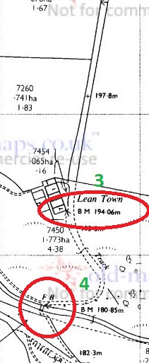
Number 3 should have been on the south east corner of the row of houses – I looked and couldn’t see anything (I didn’t look closely – nobody wants to be ‘that man who peered over our gate’, that’s how rumours start). According to this bench mark spotter’s website, the mark is definitely still there, but alas, I have no photo to show you.
Number 4, however, was there, on the stone base to the bridge across Bray Clough Brook.
The bridge has never struck me as being particularly old, and the bench mark doesn’t show on maps until the 1960’s, so I presume this is contemporary with Number 2 above. Anyway, here we are at 180.85m above sea level.
Bray Clough Brook joins Long Clough Brook a little farther upstream, and in turn it joins Glossop Brook at the bottom of Primrose Lane – I blogged about the confluence here.
Right then, I think that’s about it (I can hear you, you know, breathing a sigh of relief). I will try and be a bit more frequent in my posting… and try to tackle smaller subjects! When I started to write this, I really had no idea how large a post it would become! But there you go. Please, any comments and ideas are always welcome. More soon, I promise.
Glossop is a town made up of towns, you may have noticed.
I have a blog post about 30% written that describes each of them, but briefly they are: Milltown, Jerry Town, Charlestown, Rough Town, Howard Town, Freetown, Top o’ th’ Town, and Lean Town, the subject of today’s blogpost.
Lean Town is Glossop’s lesser known ‘town’, but is the most easily defined – it is simply a row of terraced houses in Whitfield, at the end of an unnamed track that comes south off Hague Street.
Hague Street runs NW-SE, and an unnamed road runs due south from Hague Street, to Lean Town (circled in red).
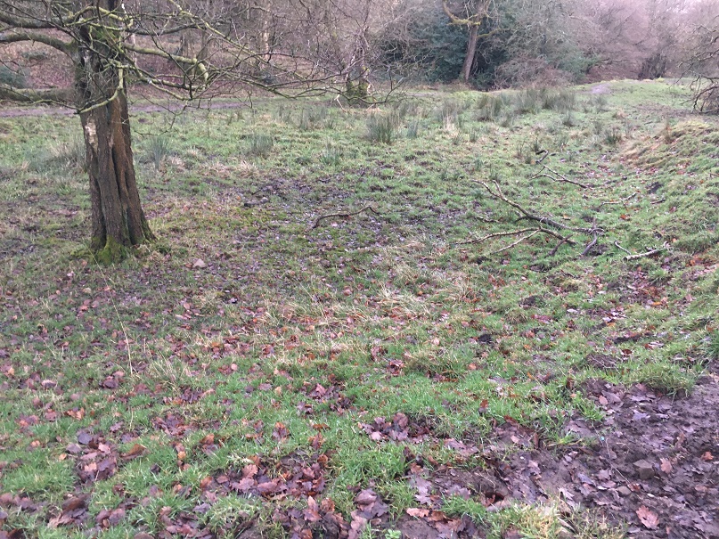
Lean Town from the south east. the path down to Bray Clough is behind the camera.
The name origins are obscure, and even the usually reliable Robert Hamnett states “why it is called Lean Town, I have never been able to find out” (and he normally knows what he is talking about, does that chap). A number of possibilities present themselves. The ‘Town‘ element is easy and obvious “a township, or community“, in this case used loosely to describe the small group of houses. ‘Lean‘, however, is a bit more difficult. I have always thought it refers either to the land hereabouts – lean in the sense of not very good for growing crops – or the people living in the houses i.e. they were poor. Another possibility is that it refers to the houses ‘leaning’, that is perched on the edge of a steep hill, which they are.
You can get a feel for just how perched or ‘leaning’ they are from this shot, taken from what is essentially the floodplain for Bray Clough, behind me.
Annoyingly, it doesn’t feature in the 3 volume set of The Place-Names of Derbyshire at all, but then that is not surprising, as the book is woeful in its shortcomings, leaving out dozens of local place and brook names that I know of – there must be thousands more. However, looking in the much more comprehensive The Place-Names of Cheshire for similar sounding possibilities gives the following:
Lyng (Old Norse), ling, heather.
Given its location on the edge of the common land that was, and still is, covered in gorse and heather, I am now starting to lean* towards that as an explanation. Over time, Lyng, the name descriptive of the area, becomes Lean, and is then attached to Town – Lyng Town/Lean Town. Perhaps. Maybe. *Pun fully intended.
Is this the origin of Lean? Heather and gorse just by Lean Town.
Anyway, let’s move on!
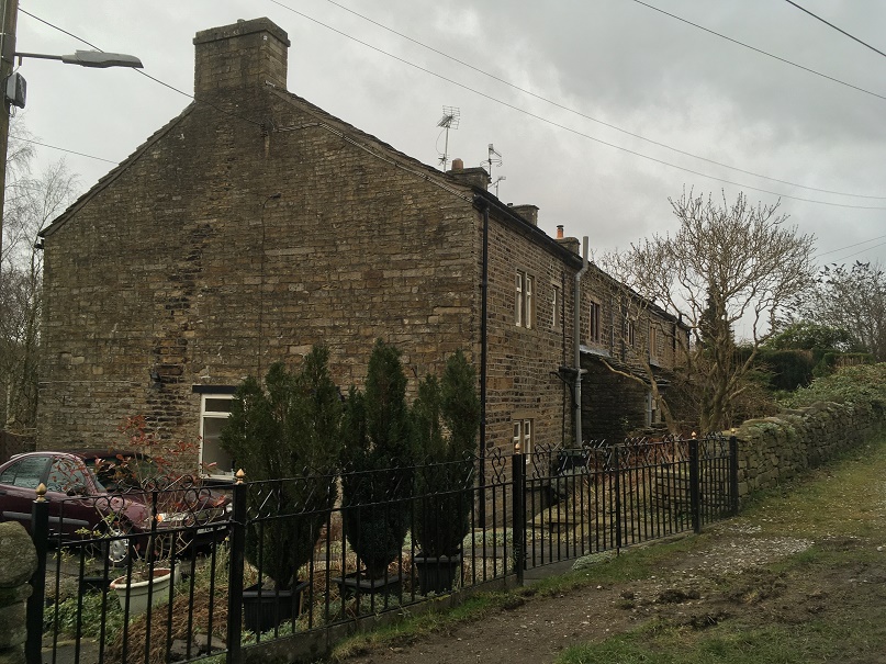
According to Hamnett, the houses here were built in 1806 by Elizabeth Hampson, a member of a well known local family, who were responsible for building large numbers of the houses in the Whitfield area. Originally there were four terraced houses of a typical late Georgian/early Victorian design, stone built, with stone mullioned windows, and a stone roof. I’m not sure how many houses are there now, or whether any have been knocked through – there are still four chimneys, though.
The date of construction fits nicely with what we know of the area, which was radically changed at the end of the 18th and early 19th centuries, when the area was enclosed. The process of enclosure saw what was previously ‘common’ land, available to all, was closed off and sold to private individuals. These landowners built walls around the fields, creating the landscape that we know so well; prior to this, the whole area was just open moorland and fields. Indeed, the gate to the moor here was situated at Lane End Farm – as the name suggests, here the lane, or Hague Street as we now know it, ended, and beyond it was just common moorland. With the sale came certain stipulations laid down in law, particularly the creation of roads, and many of the roads in this area were created at this time: Kidd Road (originally called Whitfield Green Road), Derbyshire Level (originally called Hurst Road), Hague Street, and even Gladstone Street. All were declared public carriageway, and were ordered to be 30ft wide (go get a tape measure and have a look!). The unnamed track, at the end of which sits Lean Town, was created in c.1813, it was declared a bridleway, and ordered to be 10ft wide. Presumably it replaced an earlier path down to the houses, unless the dates are slightly off. What is interesting is that the path marks the limit of the ‘ancient enclosure’ (that is, the medieval or early modern enclosures) – if you stand at the top looking down to Lean Town, all that is to the right of you is ancient, and to the left of you all was common land until the early 19th Century.
The walled space at Lane Ends Farm dedicated to Norman and Irene Greenhalgh of Lane Ends Farm. To the left is Kidd Road, to the right the unnamed path down to Lean Town.
Behold, the unnamed path down to Lean Town. A bridal path built in 1813 or thereabouts, and by law to a width of 10ft. It probably replaced an earlier path to the houses from Lane Ends.
Like I say, a huge upheaval – people lost their right to graze livestock, and even the right to cut peat for fuel for their stoves . The peat fields were moved much farther away, but I believe that residents of Whitfield still have the right to cut peat – don’t quote me, of course, and I’m not sure a multi-fuel burner could handle peat to be honest. There is an interesting account of the process of enclosure in Whitfield here.
If you look at the map above, you can clearly see marked ‘well’ at the end of a path from Lean Town. Now, having a thing for wells, I obviously set forth to see if anything remained. No, was the short answer. Here is the location, and the area is wet, but there was nothing that might be termed ‘well’. Ho hum.
The location of the Lean Town well. I’m not sure what was here originally – perhaps just a trough, or spring head, but there is nothing there now, alas.
Right ho, that’s the end of Part 1. Part 2 contains all kinds of goodies in the form of finds, (lots of) pottery, and bench marks… what’s not to love? Oh, and a witch! You can hardly contain your excitement, I know, and I feel the same. It’ll be up soon, honestly – it’s almost done.