A bit of a quick one today, exploring one of the lesser-known, and certainly overlooked, bits of Glossop. Truthfully, I thought there might be more of a story here – perhaps even some pottery – but alas, there is very little to be said about today’s subject. I’m really not selling it you, am I? Ahem… so then, ladies and gentlemen, may I present Moodsbottom Bridge.
Can anyone else hear crickets? And why is that tumbleweed cartwheeling across Victoria Street? And what’s that I hear you cry? “I say, old TCG, where is this Moodsbottom Bridge of which you speak?”. Well, quite!
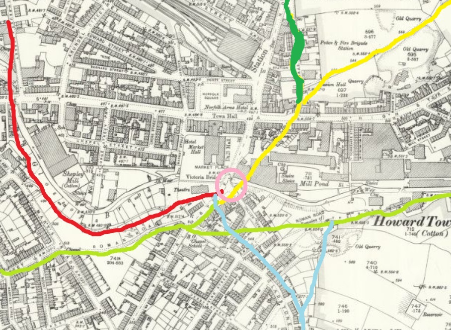
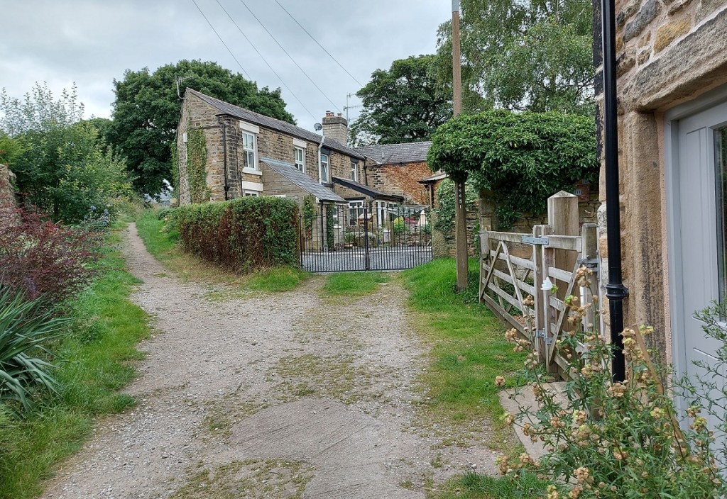
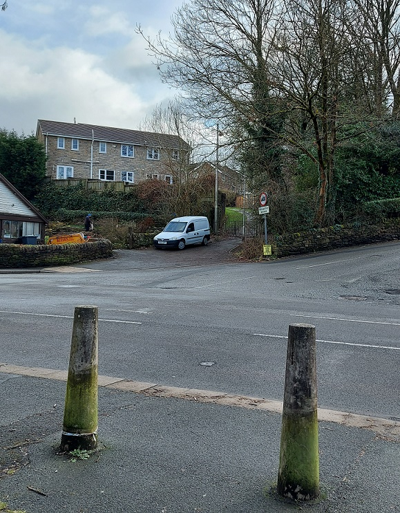
So then, it’s here…
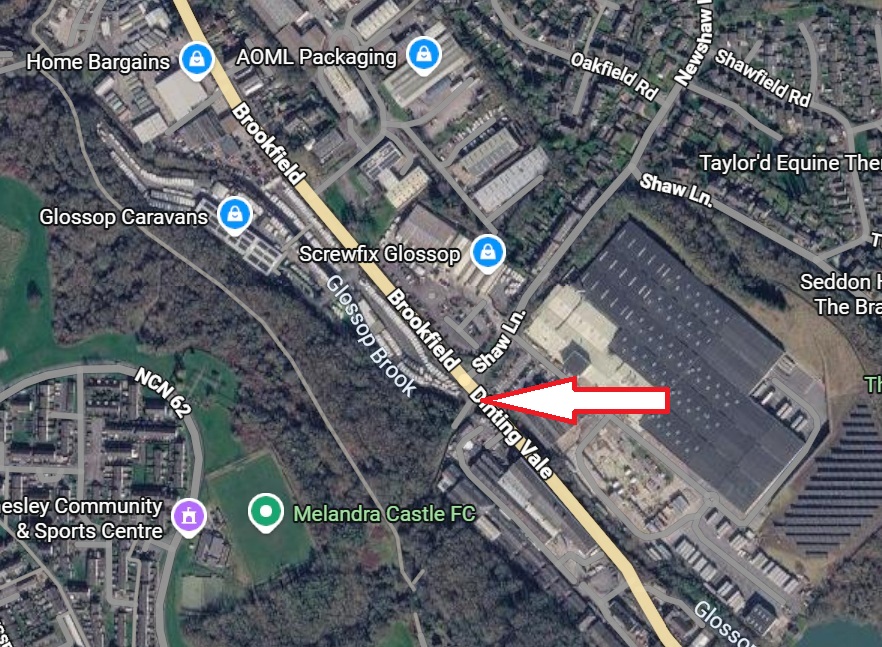
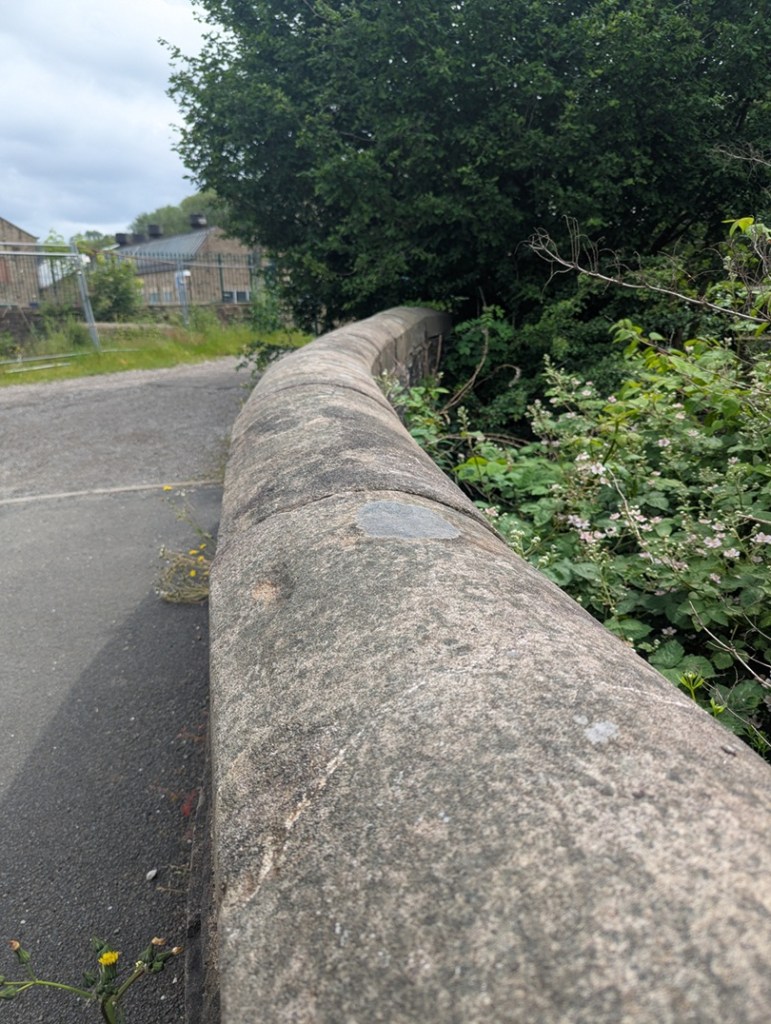
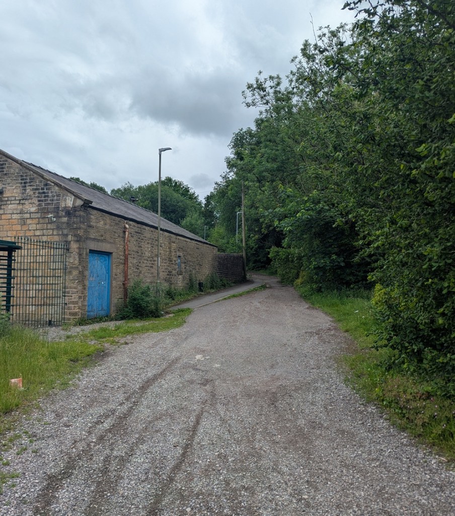
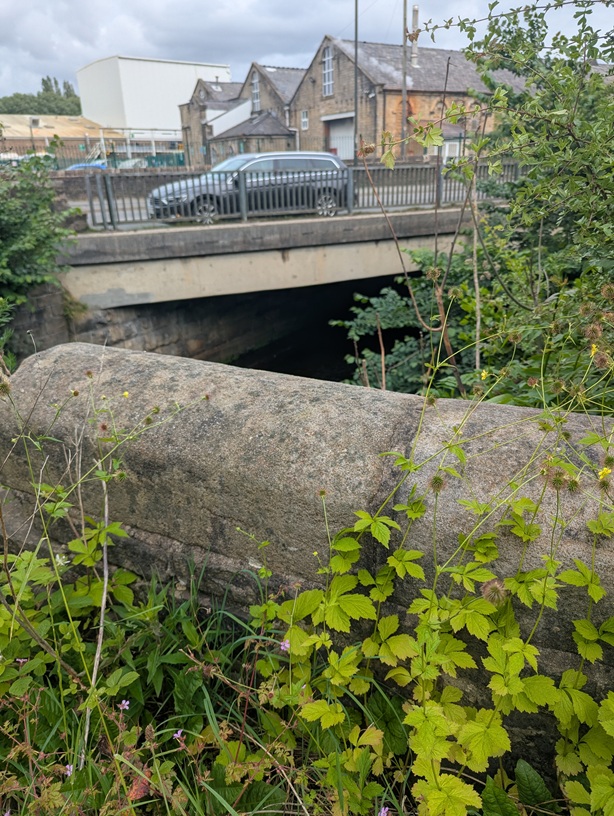
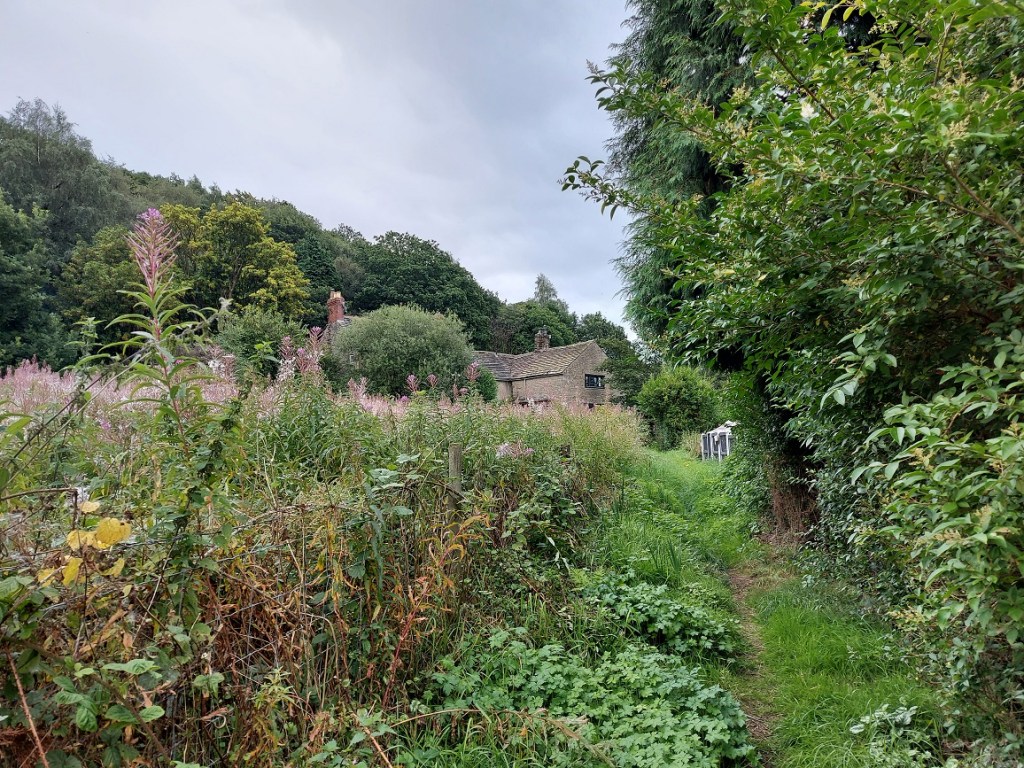
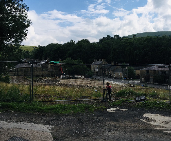
Just before Glossop Caravans on the left, and at the junction with Newshaw Lane, it crosses over Glossop Brook. You will have driven past it thousands of times, and perhaps even vaguely acknowledged it was there, sat in traffic, but unless you were actively seeking it, you would simply overlook it. By the way, it should not be confused with the ‘modern’ bridge over the brook, the one you drive over in the line of traffic that ignores the older bridge on the left.
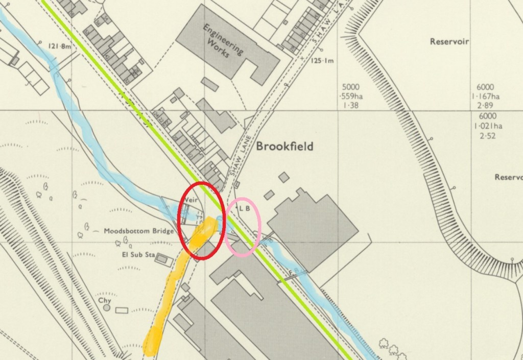
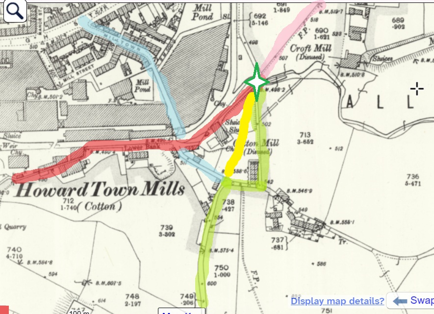
My skills with Microsoft Paint knows no bounds!
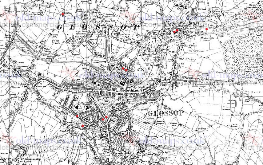
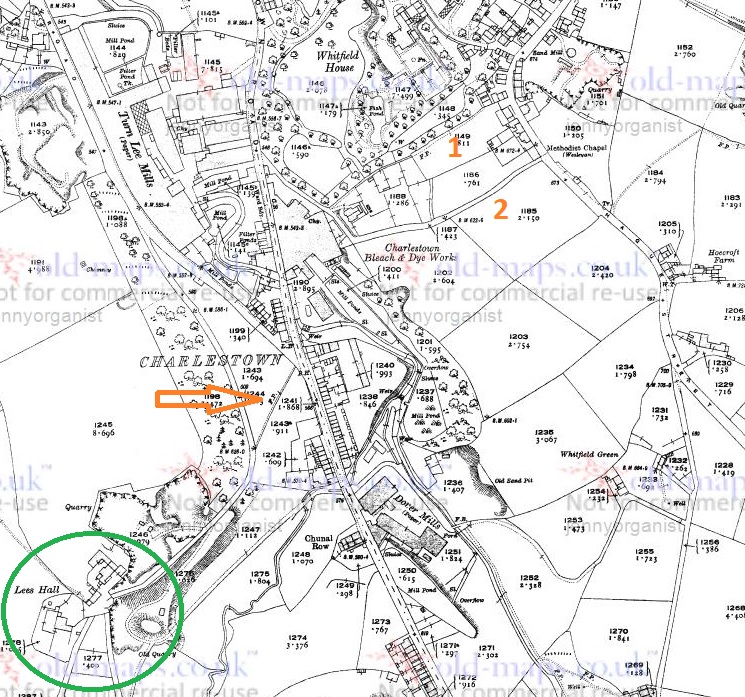
To clarify, in this image, we see Glossop Brook (marked in blue), the line of the modern road (in green), Cottage Lane (up to Gamesley, in orange), the new bridge carrying the modern road (originally the Turnpike Road, and circled in pink), and our bridge – Moodsbottom Bridge – circled in red.
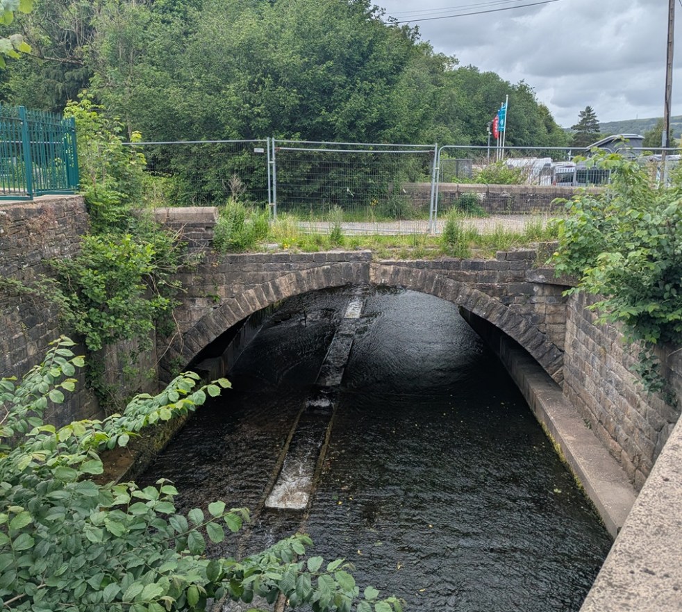
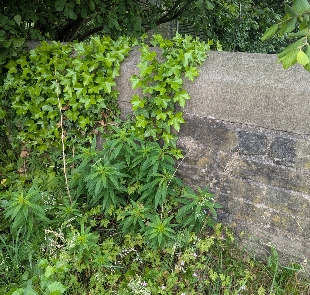
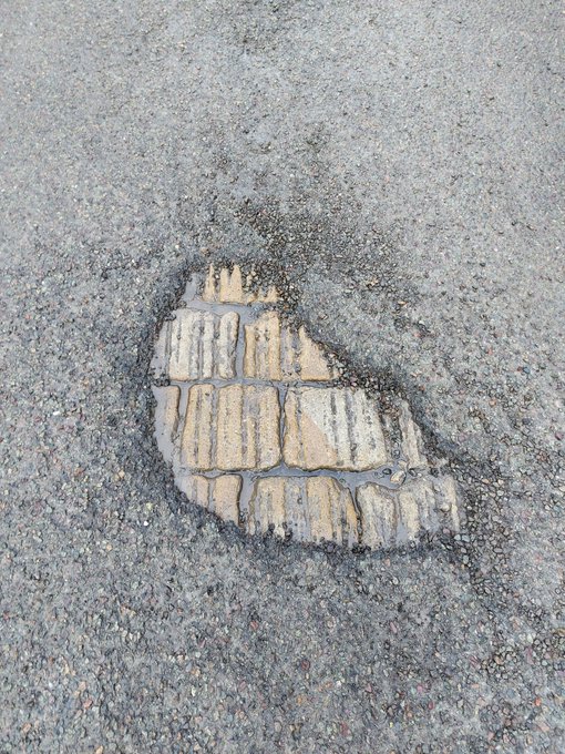
Here is the bridge as viewed from the road – it’s lost some of it’s walling, and is in a poor state of preservation, but this is what is visible now.
Glossop Brook – leading to the river Etherow – has been seriously monkeyed around with, and the whole area has been landscaped.
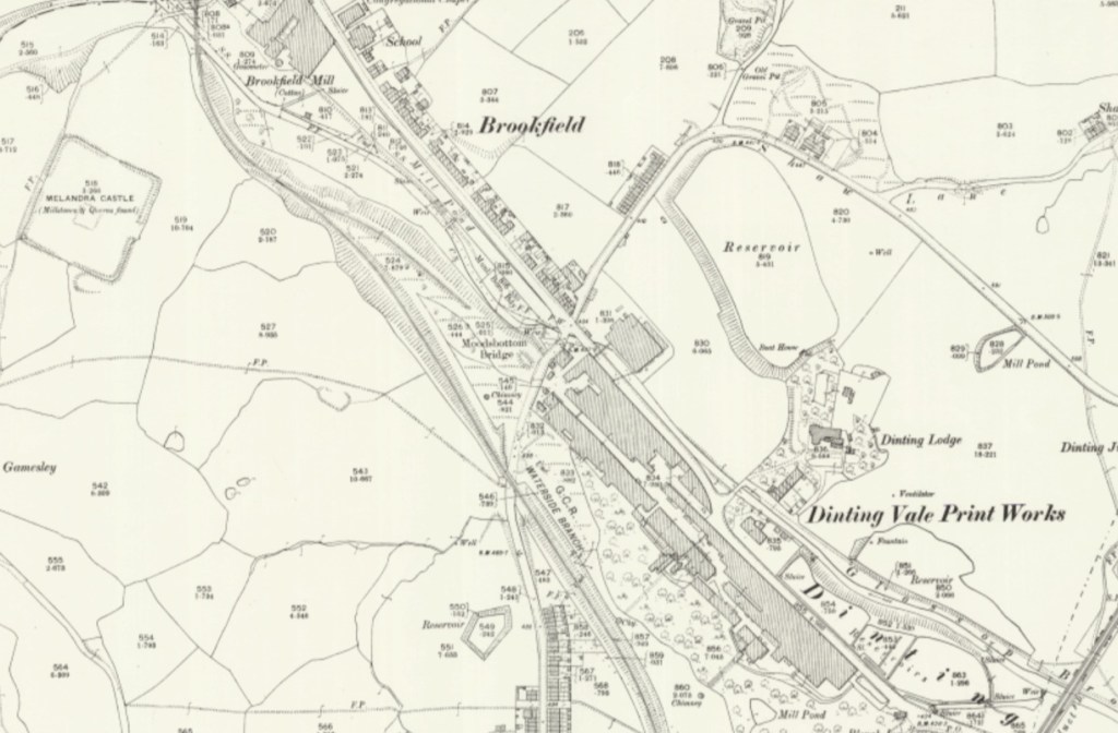
It seems to have been a fairly important crossing at one point in the past, and is the latest visible aspect of the crossing which probably started as a ford across Glossop Brook. Looking at older maps, it seems to take the track from Mottram, Hague, and Lower Gamesley Farm across the brook, as well as a track from Hargate Hill, crosses, and then up to Hadfield via Shaw, and (Old) Glossop, via Dinting. It was clearly the meeting of many of the old tracks that existed in the pre-turnpike era (pre-1800 or thereabouts), and one of only a handful of crossings of the brook.
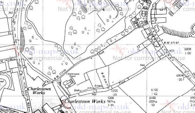
25″ OS map from roughly 1900
And yet truthfully, though, I’ve no idea of the age of the crossing and bridge, and its history is confused and murky, which is a pity. There is very little discussion in any of the history books or articles, and a brief google of “Moodsbottom” produces just 10 hits (11, now, I assume).
As if to illustrate this frustrating murkiness and general lack of knowledge, the earliest reference to the bridge I have found is from 17th February, 1794, when the trustees of the newly formed turnpike trust ordered “the river below Moodsbottom Bridge be piled to prevent carriages travelling to the coal pits”. “Piled” here probably refers to having the river bank’s sides made steep and secure with piling, to prevent the carriages from fording it, and thus avoiding the fees for road use. But the turnpike road (now the modern, green, road in the map above) was only put through in 1804 or so, some 10 years later – so why the trustees of the turnpikes trusts were making this ruling is not clear.
At about this time (1795), according to Robert Hamnett (quoted here) a John Loton built three houses at “Gamesley Bridge” (not the viaduct over the railway, which was built in 1843). There was also a white cottage belonging to a Roger Dumphy; possibly an older building, it had some ‘pleasure gardens’ at the rear, which were apparently quite popular. Presumably these all stood on what later became known as Cottage Lane (in orange, on the map above), and which was apparently named after Dumphy’s White Cottage.
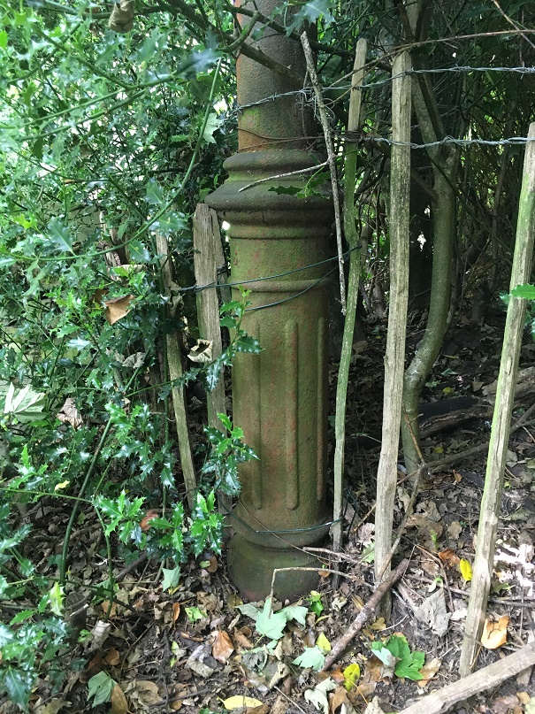
We also know that on 17th December 1863, a meeting of ratepayers was held to discuss the making and improving of certain highways. This was in response to the ‘Cotton Famine’ of the mid 1860’s, when raw cotton ceased to be imported from America due to the ongoing civil war there. The effect of this was to put thousands of mill workers out of work, and create hardship and poverty throughout the area. In order to mitigate the effect, jobs were ‘created’, and large numbers of public works were initiated – including the creation and improvements of many roads in the area. Among these were “the making of a public road from the Glossop and Marple Bridge turnpike road, at Gamesley, to the Glossop and Marple Bridge turnpike road at Moodsbottom Bridge.” – that is, what we now know as Cottage Lane. Looking at the stonework, it would seem that the current bridge dates to about that time, and the whole area seems to have been reconstructed and formalised then. What the bridge would have looked like prior to this is unknown – stone, but less… well, Victorian!
So what is there now? Here are some photographs taken last week…
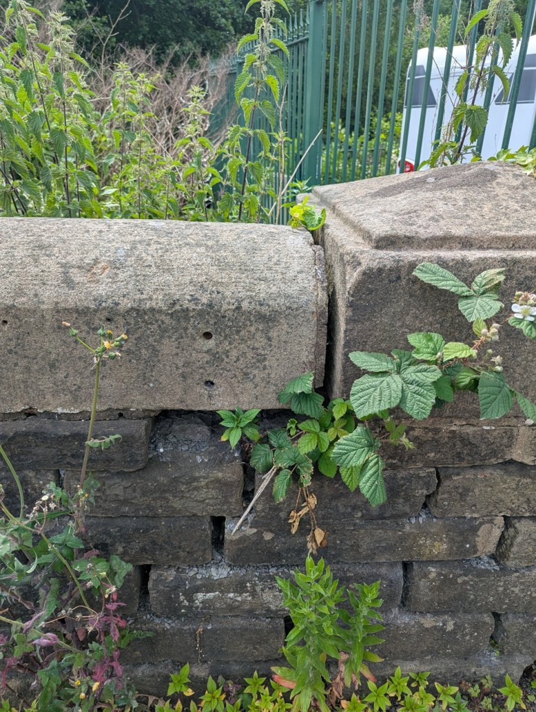
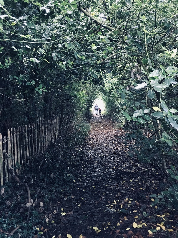
Close up of the ivy clad western wall. Another close up of the western wall. Another shot of the western wall, snaking into the distance along Cottage Lane, the lovely dressed Victorian stonework smooth and tactile. Cottage Lane – a particularly rough track all but impassable now. The large stones in the road are, I suspect, the remains of the 1863 rebuild, or even of an earlier build. And no, there was no pottery to be had anywhere around here… depressingly!Looking up Cottage Lane from the bridge.The partly collapsed eastern wall. This shows the construction method – presumably an iron rod was placed into the hole in the end of the roughly dressed stone, joining it to another similarly shaped stone. Another shot of the eastern wall, this part still intact, and showing the modern Moodsbottom Bridge behind it. The view from the bridge at the crossroads: behind us is Cottage Lane, ahead is Shaw Lane, and running left-right is the A57, the turnpike road constructed in 1804.
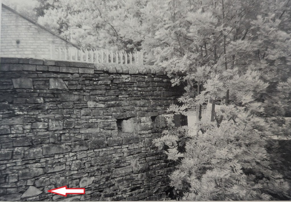
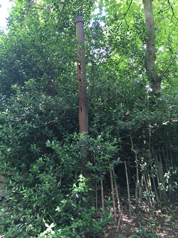
There is an interesting aside in Neville Sharpe’s book, Glossop Remembered, where he notes that during WWII, the local Home Guard put gun loops (holes that allow soldiers to shoot through) into the wall belonging to a factory that overlooked the bridge, allowing rifles and machine guns to train up the road that comes from Woolley Bridge (and Hollingworth) – the likely direction of invasion into Glossop from the west – and up Newshaw Lane to the north: even in 1940, the bridge held strategic importance.
Neville Sharpe’s photograph, in which the holes are clearly visible, as is their direction – imagine guns pointing out of them. Note the arrow pointing to a triangular stone
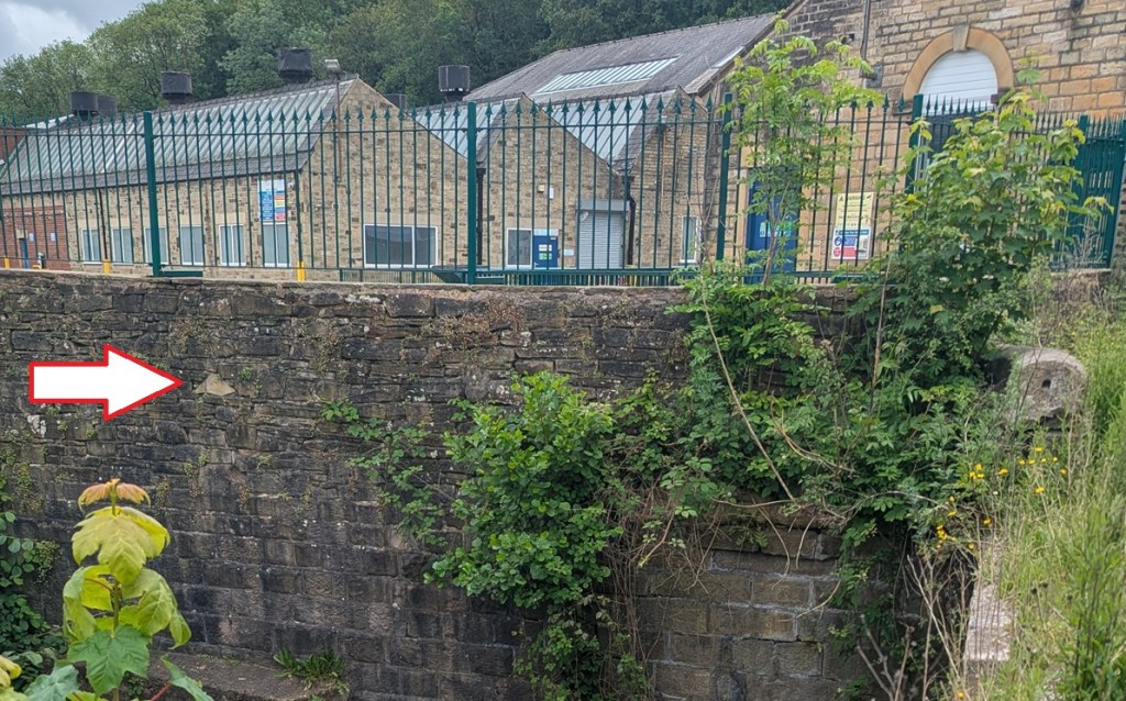
Alas, as so often happens, the evidence of the past is erased – the wall has been truncated since the above photo was taken (1980’s? 1990’s?), and as this modern photo shows, what we are left with is… not a lot. You can see where the loops were by spotting the triangular shaped stone in both photographs, indicated by the big white arrow!
The whole row of stones that includes the gun loops – and upwards – has been removed.
Incidentally, logically there must have been a similar defensive position to the east – somewhere at the bottom of the snake pass, in order to protect that road – and I think I might have a likely location! Let me check it out, and I’ll let you know what I find…
The name is interesting, though. Moodsbottom? What does that mean?
It’s named as “Mousbottom” in Ralph Bernard Robinson’s Sketches of Longdendale (1863). This seems to be a contraction of ‘Mouselow Bottom’, and may account for Moodsbottom, which sounds very similar. But – and here we stray into ‘placename’ territory – I have another theory, one that plays into the idea that Mouselow was a hugely important site in the Saxon period as well as the Iron Age, and early medieval periods.
I suspect that Mouselow, the Iron Age hillfort that sits just above Moodsbottom, was used in the Anglo-Saxon period (let’s say 9th and 10th centuries), holding a special status as a Moot place – where the local ‘council’ of surrounding villages held monthly meetings to discuss issues such as land use and roads, for example. I discussed moots here in regards to Mottram, and I have a whole article almost ready to go about this, but one of the central ideas is that ‘Mouselow’ is derived from ‘Motts Low’, the ‘mound’ (low) of the ‘moot’ (mott). If this is the case Moodsbottom is derived from ‘Moots Bottom’ – the bottom of the moot… which it is. More on this soon, I promise, but for now I’ll leave you with that tantalising glimpse.
So, there you are, a small piece of Glossop’s history, imperfect and not fully understood, and very much overlooked, but full of a possible story. Wonderful!
In other news… the latest Where/When has landed in the shops – both physical and online. Behold: The Broadbottom Bimble!
It’s a circular Wander from the station (well, let’s face it, the Harewood Arms), to Far Woodseats Farm and back, via Broadbottom Beach, some amazing standing stones, medieval fields, Georgian and Victorian factories, packhorse tracks, bridges, brooks, and some incredible geology. What’s not to love?
It’s available now, as indeed they all are (No’s 1-9) from Dark Peak Books at 96 High Street West, Glossop; from my Ko-Fi shop (and do feel free to buy me a coffee, or a glass of the stuff that cheers); or just find me in the street, hail me with a hearty “what ho!”, and I’ll give you one. Cheers, and happy Wandering.
Right, that’s all for this time. More to follow, soonish… probably. And whatever does follow will be pottery based – maybe even the final instalment of the pottery guide, or an updated version of the already published guide, you lucky folk, you.
Whatever comes, look after yourselves and each other. We live in turbulent times all around us, and each one of us is going through our own personal things. So let’s be kind to one another, because we all matter.
No, fear not, dear and gentle reader, I have not had some sort of ‘attack’, or a fit of the vapours, or conniptions, or a melancholic fever, nor indeed some form of ‘brain disorder’ resulting in a sharp dose of the ‘lah-lah-lahs’ (despite what some of you may think). I am tickety-boo; hunky dory; cock-a-hoop; and all is, in fact, distinctly oojah-cum-spiff… I am perfectly normal. Honestly, and all shall be revealed, so stick around.
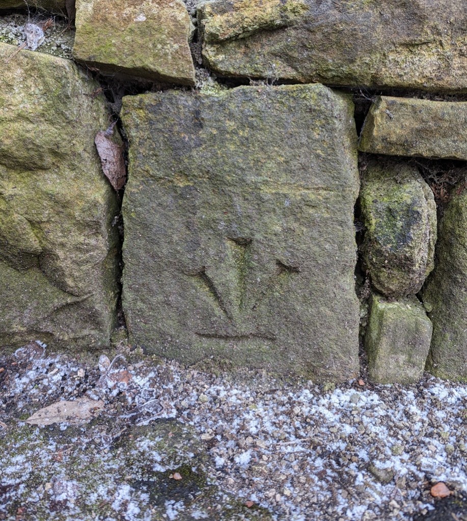
What ho, wonderful folk, what ho! Spring is upon us: I have seen sweet blessed blossom on trees, and daffodils. Oh, daffodils! Now, if it can just stop raining for a minute or two, I might actually dance. But enough of this frivolity, let us look at some bench marks! Stop that moaning, you at the back… it’s unbecoming of a gentleman.
If you have spent any time on this website you will know that have covered Ordnance Survey bench marks before. Several times, in fact. And will also know that I love them with a passion. What on earth do you mean “obsessed” – I have an interest, that’s all. I can handle it. It’s not like I approach strangers and tell them all about benchmarks. Often. Well, not since the rather nasty court case and the restraining orders. Anyway, let’s move on. Swiftly.
For those of you who don’t know (but dash it all, you should know), an Ordnance Survey benchmark is a mark carved onto a building or other immovable object that marks out a specific height above sea level. They are most often found as an arrow with a line above it:
The ‘broad arrow’ denoting British military ownership – Royal Ordnance – with a line on top.And here is one in real life – this one being precisely 682ft above sea level.
They are the remains of the original, and subsequent, surveys made by the Ordnance Survey in the 1840, allowing engineers and surveyors to record the whole country by height and distance. A remarkable feat, when you think about it: with each mark being intervisible with another, they are a literal network of heights, which, whilst visible in plain sight, is nonetheless overlooked or simply not known about by 99% of the population. I first encountered them whilst working as an archaeologist in the Oxford area where we used them to provide a height for the sites we were working on – essentially using an old fashioned level and ranging rod, we leapfrogged from the benchmark on a church to our site about a mile away, as this was the nearest benchmark, and we were working in the middle of nowhere! Benchmarks are marked on older OS maps, and they are found in their hundreds of thousands all over the country.
The system is no longer maintained, sadly, and they are falling into disrepair, but are much loved by nerds such as myself, who become, against their better judgement – and ignoring vague threats of divorce – Benchmark Baggers.
Now, occasionally, mistakes happen. The Ordnance Survey is very – painfully – good at what it does, but the people it serves – us – are not. Benchmarks go missing, or are moved, and sometimes too they are marked on buildings, but seem to have not been marked on maps. That is what this post is about – the anomalies and the oddities, not so much a benchmark… more a menchbark.
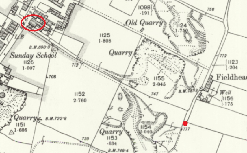
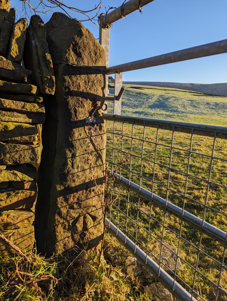
We start with Fieldhead Farm, Whitfield. The farm building itself has a benchmark, but nearby is a gatepost with a clearly carved benchmark on it; proudly stating the height above sea level of… we don’t know! It’s here on the map:
The Beehive pub is circled in red, for reference, but the benchmark is marked by the red dot.
There’s the mark, but the OS have never marked it on any map I’ve ever seen. And I don’t believe it has been moved from anywhere, either – that’s a solid piece of gatepost! Interestingly, it does replace a smaller square-holed medieval/post-medieval post. This is a very curious part of Whitfield that has a greater history than we currently understand – even the name ‘Fieldhead’ may suggest medieval origins.
Nearby, on Derbyshire Level is this lovely example:
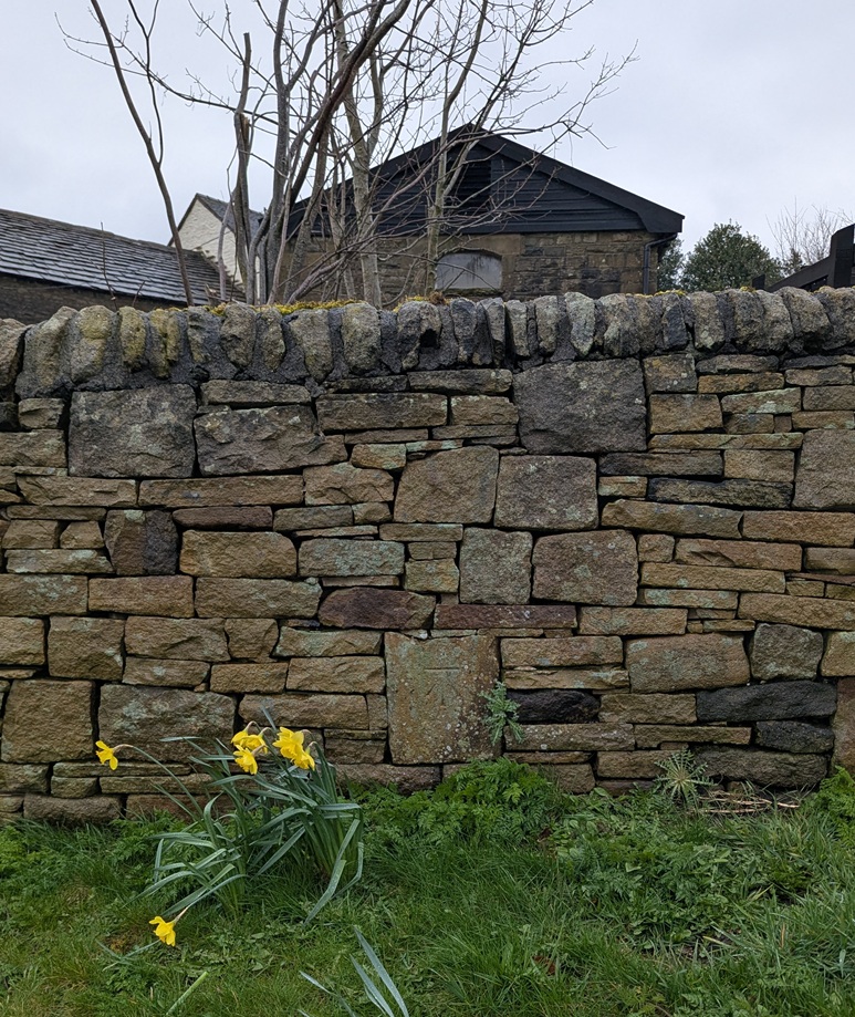
This one was originally in the wall of the garden of Lane Ends Farm, Derbyshire Level. It still is in the wall, but the wall has been rebuilt fairly recently, and whilst it originally marked a height of exactly 705ft above sea level, and has been replaced in roughly the same place (amazing work, whoever did that), Jove alone knows what it marks now!
However, at least the people who rebuilt the wall understood that the benchmark had a purpose… and a right way up. Whoever rebuilt this wall in Hadfield – under the disused railway just by the start of the Longdendale Trail – had no idea what to do with it, so the benchmark was replaced upside down:
I mean to say… given that benchmarks for me represent an unmoving, permanent and fixed, point in a chaotic world (and mind), the sight of this inverted mark is literally turning my world upside down… and quite frankly gives me the heebie-jeebies.
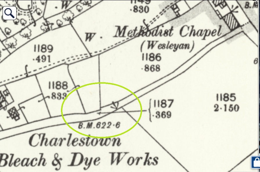
Here, on the southernmost of a pair of paths between Hague Street and Charlestown Road (and discussed in this article), we see that sometimes the mark is moved, probably due to some form of destruction or movement. So in 1898, the mark is on an object to the south of the path (a gatepost that is no longer visible, perhaps):
At some stage, the mark is rendered useless, and by 1968 it’s moved to the north side, and carved onto a gatepost, itself no longer used:
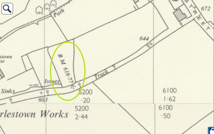
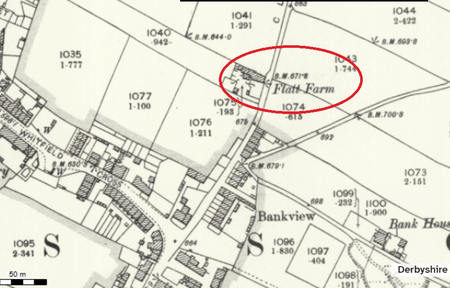
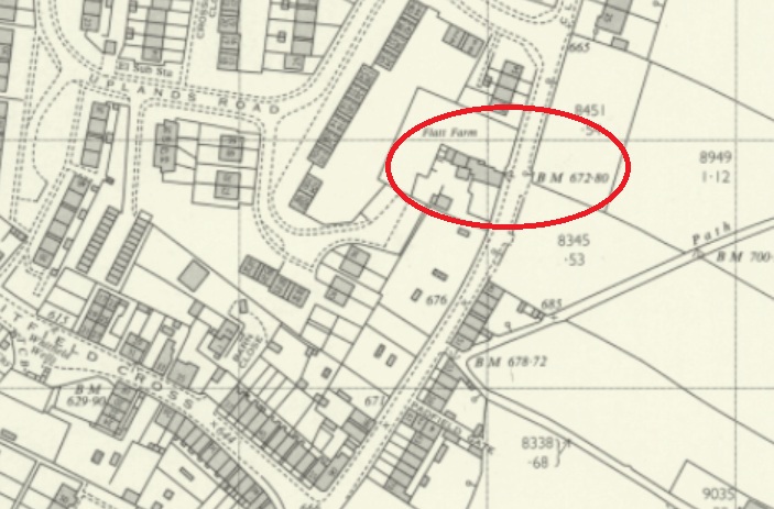
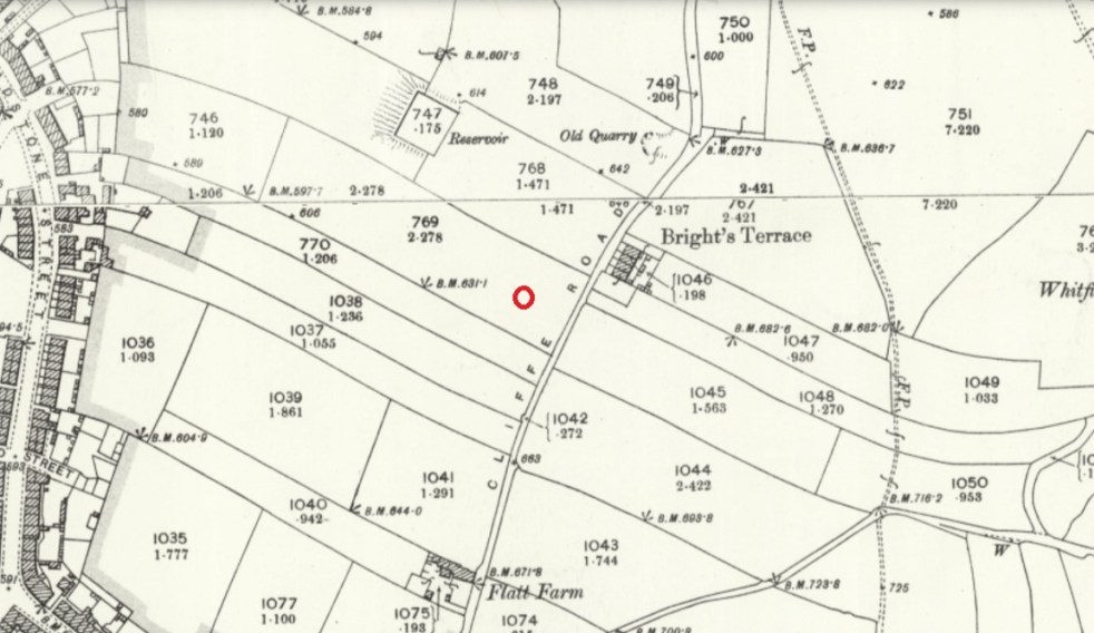
Next up, we have Flatt Farm, on Cliffe Road, Whitfield. The original benchmark is here:
1898 OS map
To the left of the building’s gable end. It is ridiculously low to the ground, with only the flat top showing – the result of the ground level having risen about 1ft.
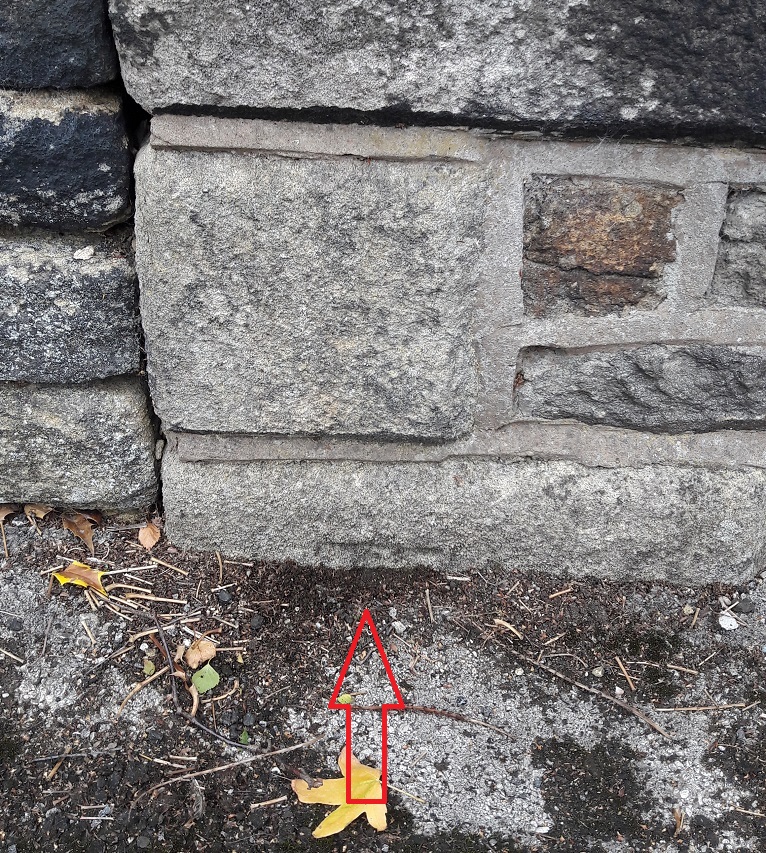
As a result, a later benchmark was cut into the right-hand side of the gable end:
A lot has changed by 1969… including the benchmark locationWorn and faded, it is there in the centre of the photograph.
The ‘new’ carving was poor by comparison, and has faded quickly, a symptom, perhaps; by 1969, the whole system was falling into disuse, and benchmarks no longer were marked on OS maps as a general rule. Sad, but there you go. Of course, now we don’t use them at all due to GPS, etc. But I honestly think there is something grounding and wonderful about them.
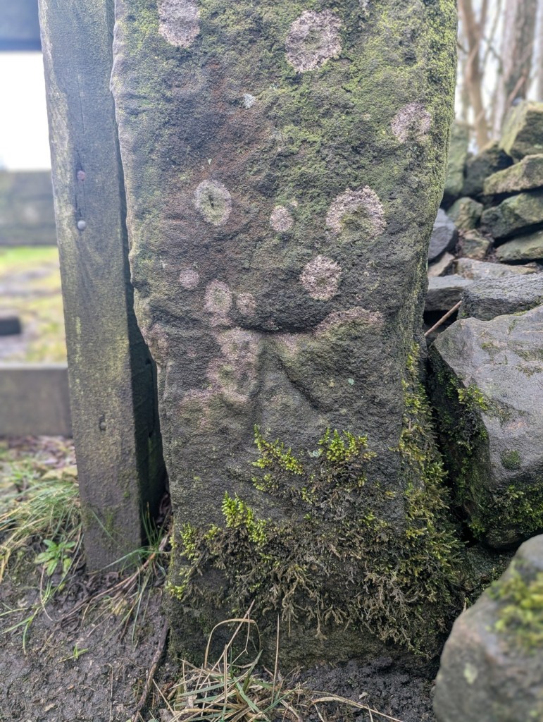
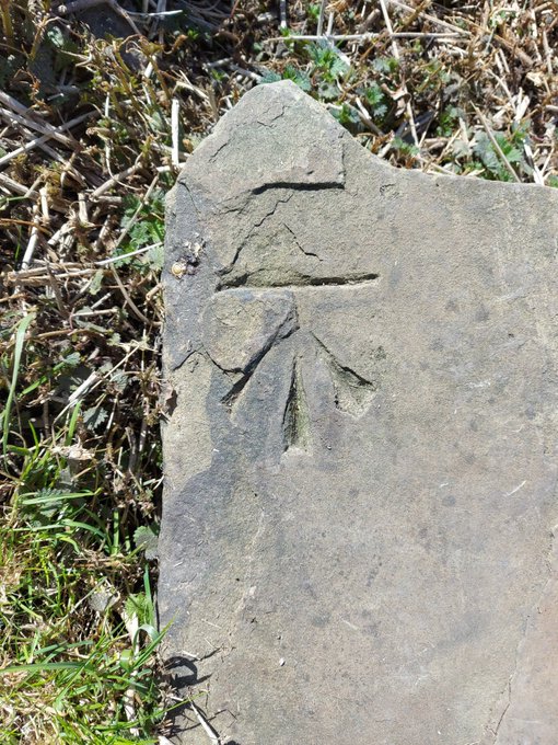
Anyway, whilst researching the latest Where/When (No.9), I discovered this wonderful specimen: potentially an abandoned attempt at a benchmark:
It’s at the right height – 1ft off the ground – and on the right sort of immovable object – a gatepost -and it would be in a perfect place for one, but it seems that during the carving process, a mistake was made – the stone may have crumbled, or a careless stroke was made, and the whole was abandoned. I might be wrong, of course, but that is what it looks like to me. You can have a look yourselves, here:
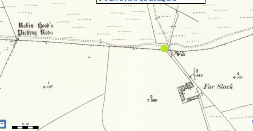
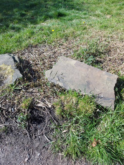
Facing the track to Far Slack farm, it’s the left hand gatepost (alos, right next to a rather spiffing holed gatepost, now lying on it’s side). The mark is also right by Robin Hood’s Picking Rods – a pair of 10th Century Anglo-Saxon Stone Cross shafts, and coincidentally, the stars of the latest Where/When – see below. Definitely worth checking out.
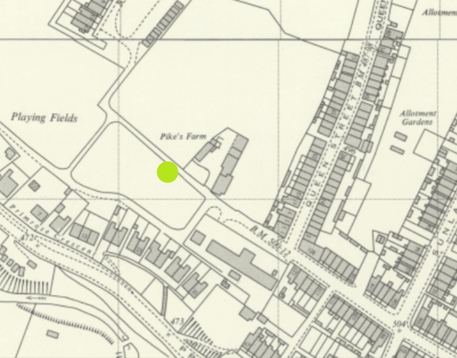
We’ll end on that most rare thing… a feral benchmark. Escaped from who knows where, it lurks, in a recumbent posture, and mocking all attempts at identification, just by Pikes Farm at the end of Pikes Lane. It’s been dumped from somewhere… but Jove knows where!
It was once on an upright gatepost, but is made from a non-local stone, so may have been brought from a distance. I contacted the OS, and they have no knowledge. A welcome visitor in our town, found here:
Left hand side of the track, just after Pikes Farm.
So there we go… interesting stuff. Well I like it, and I hope some of you like it too. Not you, Mr Shouty-Outy, we know, not you.
If you’re interested in benchmark bagging, I have recently begun using a phone app called TrigFindAR to help me find them. It has an almost complete map and database of benchmarks across the whole country, and allows you to tick them off as you find them (make them go from red to green) and to get onto the database kept at bench-marks.org.uk and look at that particular benchmark. I’m not sponsored – sadly – but it is truly a superb bit of kit, and is totally free; I cannot recommend it enough for you geeky types out there.
Elsewhere, the new edition of Where/When is out!
It’s an exploration of Cown Edge, Coombes Edge, medieval, prehistoric, and Roman archaeology, and a journey from The Beehive (Whitfield) to The Hare and Hounds (Simmondley). Essentially a guided walk around some really cool old stuff that starts and ends at a pub… what’s not to love. Think of it as a paper form of this website, but involving footpaths and loads to explore.
Available for £6.50 from the Where/When link above, or through the amazing Dark Peak Books and Gifts on High Street West, Glossop. Or just stop me and buy one!
Right, I’m off. I’m tired, grumpy, and am due a glass of the stuff that cheers any moment now. More soon, I promise, but until then, look after yourselves and each other. Please. We are all important, even if we don’t feel it sometimes. And until the next time, I remain.
What Ho! And a happy New Whatsit to you all, yes, even you Mr Shouty-Outy, even you.
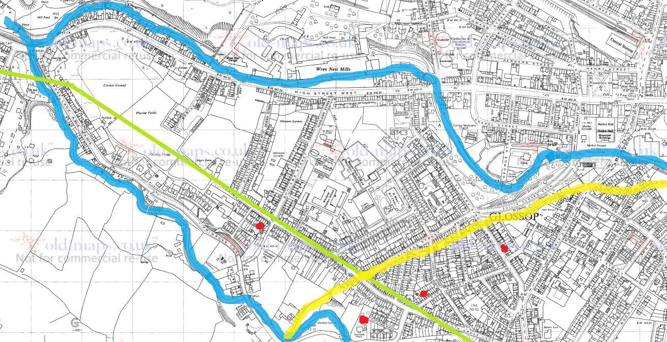
So, I was wondering down Cliffe Road in Whitfield the other day – actually on my way to Lidl, since you ask, and yes, to buy a bottle or two of the stuff that cheers… amongst other things (mainly cheese, if I’m honest). The road dives steeply down, and then takes a left turn at the bottom, and leads past the new build houses on the old Velocrepe site and onto Milltown. Now, I’ve always found this stretch of road very interesting. The main road from Chapel en le Frith to Glossop (and beyond), and thus Anglo-Saxon in date, it originally seems to have carried on straight, where it joined The Bank – the medieval/Post-Medieval track coming from Simmondley to Glossop – and together crossed Shelf Brook via the foot and road bridge at the entrance to Shirebrook, but was presumably then a ford or basic bridge. The route of this track was altered when a mill was built here, probably in the 1780’s (dates are a little fuzzy), and a mill pond put where it once ran. The newer route was/is to the right, and then down, past some mid 19th century houses there. Here, this carefully and skilfully annotated map explains it better visually than I can with words:
Green – Cliffe Road, with the right hand kink, and then straight ahead. Blue – the left hand late 18th/early 19th century extension to Milltown. Red – The Bank, the road from Simmondley to Glossop. Yellow – the original route of Cliffe Road, moved when the mill and millpond were put there. Green Star – the location of the crossing over Hurst Brook (a ford or bridge). Pink – the route from the bridge to Glossop.
But here I am again, getting distracted! This post is not about the tracks… well not as such. But rather, what such tracks were made from. The earliest tracks were simply mud, and were impassable in the rain, or with winter blowing cold, and Glossop was notorious for its frankly crap roads, which would have been patched and ‘surfaced’ with rough stones as and when it was needed, the remains of which can be seen occasionally be encountered peeking through the tracks where it has been worn.
I’m not going to go into the history of the roads in the Glossop area, as it has been covered in detail elsewhere (Glossop Heritage Trust), but in summary. it is only with the advent of the Turnpike Roads in the late 18th and earlier 19th century that Glossop finally got some ‘real’ roads. These high quality, well built and maintained, turnpike roads were paid for by a private consortium which recouped the money by charging a toll to travel on them. The introduction of these toll roads changed Glossop permanently, as it meant that the vast economic potential of Glossop’s mills could be fully realised; prior to this, mills were restricted, as it was difficult to get your finished cloth out, as well as raw materials in. Once this was problem was solved, the full brunt of the Industrial Revolution could be unleashed, bringing with it all the positives, and negatives, of this turbulent time (and if you know me, the you’ll know I’m essentially a hobbit, and so I think it was all a huge mistake!).
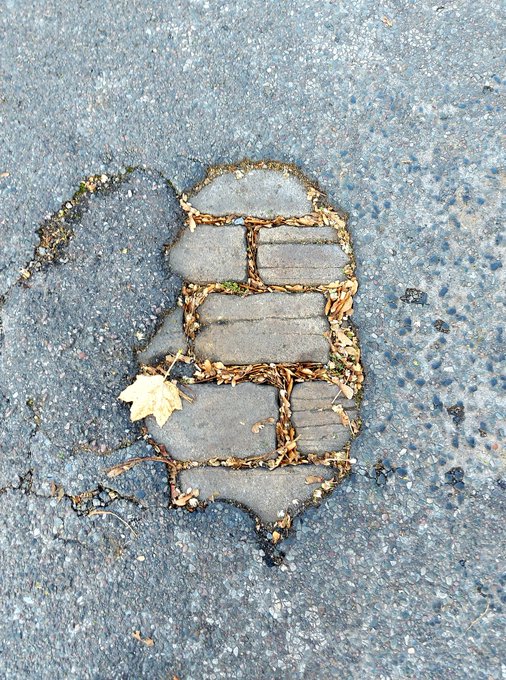
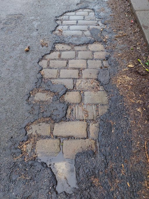
So, there I was, wandering down the bottom of Cliffe Road (in blue above), when magically, beneath my feet I saw this:
Peeking through, the past – always with us, sometimes at our feet.
The woeful state of the roads here in north Derbyshire, had revealed the original road surface; ‘What ho, setts!’ I thought.
So what are we looking at? This is the original surface of the road, dating to the time when this sideways step was constructed in the early 19th century (the datestone on the house at the bottom there reads ‘1815’, which is perfect). These are the setts that made up the road itself – a sett, which is deliberately shaped by human hands, rather than a cobble which is natural product and can be picked up off the beach. The fact that each one of these was shaped by hand frankly blows my mind! What a tedious, tiring, and unpleasant job that would have been, day in, day out. And how many 100’s of thousands… millions, would have been used in Glossop alone? Frightening stuff.
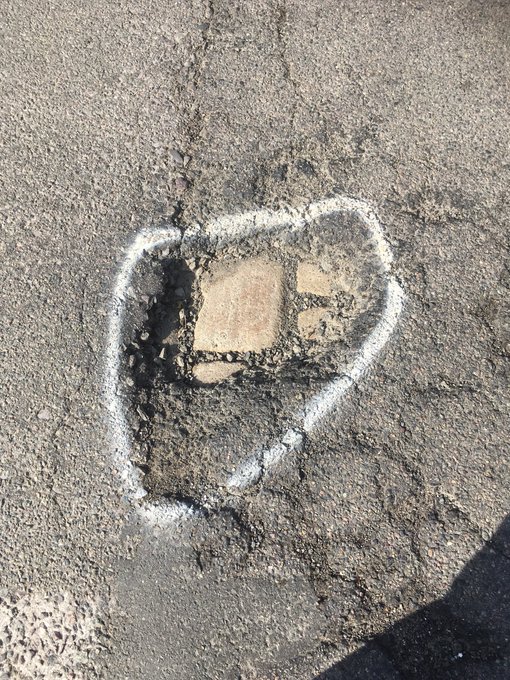
As you wander about Glossop, you can often encounter these sneaky little portals to the past, and I like to stand on them, imaging what stories they could tell. I also take photographs of them… what’s that? Hmmmm?… “I say, TCG old chap, you couldn’t show us some photographs could you?”. Well, I’m glad you asked, old bean, because I have few I could share!
These were on Wood Street
Shaw Street
Gladstone Street
The reason that we can see this is that the modern tarmac can’t get a good grip on the smooth surface of the Setts, and it simply peels of over time. They tried to solve the problem by scoring deep lines into the stone, but that doesn’t seem to have worked, either!
The scoring must have been done mechanically.
Occasionally, when there is a problem and the road need opening up, they have to pull up the setts, and you can can see how they were laid.
King Street
St Mary’s Road – you can see the setts just below the surface
Charlestown Road. Note the setts here are sitting on a bed of cinders and chalk.
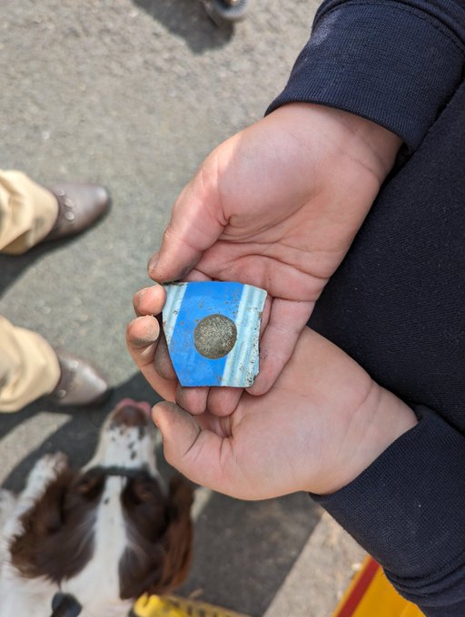
And, of course, you can sometimes get lucky with the spoil from these excavations, and find a piece of pottery… obviously you can’t have an article without pottery!
Lovely – banded ‘annular’ Industrial Slipware. In this case, it dates to not later than 1850’s.
Also, this provides us with a terminus ante quem, meaning that the pottery could only have been deposited before the road was laid down, which is the case of St Mary’s was mid 19th century, or slightly earlier. Wonderful stuff!
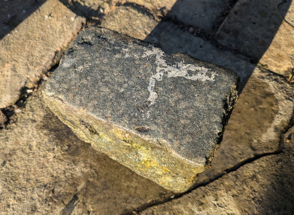
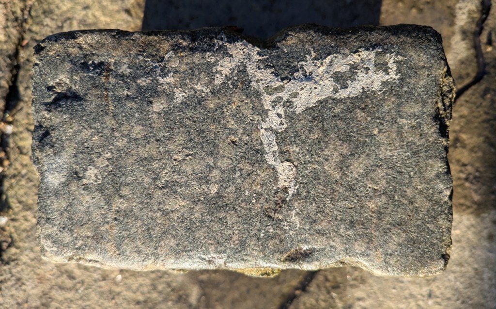
And of course, sometimes, the setts roll out of the spoil heap, and into… well, let’s not beat about the bush – my garden. It seems such a shame to just let them disappear into the truck and be driven off to a landfill somewhere, or to be used as hardcore for a new road. That saddens me greatly. So occasionally, they – magically – roll into the garden. Uphill. And sometimes over great distances. Following me home, if you will! And I can tell you this, they are heavier than they look!
A King Street Sett, a lovely grey colour. I think it had paint spilled on it as some stage.
It measures 7″ x 4″ x 5″, and has a smooth even surface. Hamnett suggests that King Street was laid out in the 1840’s and 1850’s, which makes sense.
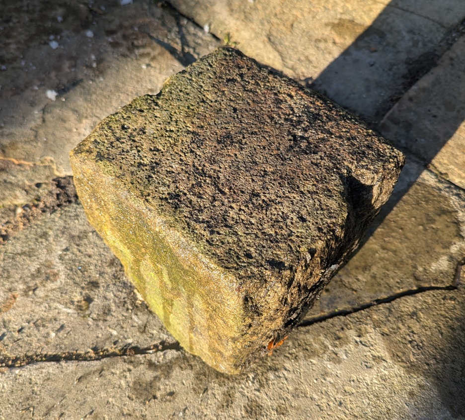
Turnlee RoadA more coarse surface.
Measuring 7.5″ x 7.5″ x 6.5″, the Turnlee Road sett is bigger, and has a rougher surface. This one is older, too, as it was presumably laid in the 1790’s when the turnpike road was put through, and is thus a real piece of Glossop’s history: who knows who and what travelled on this surface.
The King Street stone seems smoother, and thus more worn, than the Turnlee Road sett. This is odd – surely Turnlee would have seen much more traffic than King Street? But the differences may be explained by the location of the stone within the road surface; King Street was taken from the middle, whereas Turnlee was, I seem to remember, came from the edge of the road, where presumably no traffic would pass. It might also be explained by different stones being used – the Turnlee stone looks almost like a hard-wearing granite, whereas King Street seems more like a local gritstone. But I admit I am no geologist, so if anyone knows any better, please do shout out and correct me.
These are not the pretty bits of archaeology; the fancy buildings, the lovely pottery, the flint, the burial mounds, the Roman fort. Instead, this is simply the nuts and bolts of it – a road surface. And yet it has that vital link to the past, that important accessibility, that allows us a glimpse underneath the modern, and for that, I find them endlessly fascinating.
Right-ho! That’s all for now. My only New Year’s resolution this year is to publish more on the website, but to make the articles smaller, and thus quicker to write. I have another almost written, so I’ll go with that soon, and I’m working on all manner of other things, too.
Until then, though, look after yourselves, and each other, and please do get in contact with any thoughts or comments.
What ho, you wonderful people, you! Well, here we all are. Make yourselves at home. Canape? Glass of something cheering? I can heartily recommend the red… cheeky, but hexagonal in the correct places, if you know what I mean. Right, take a seat and I’ll begin.
Today’s offering concerns a subject very dear to my heart. No, not pottery… I’m not completely one dimensional, you know. Nope, this article concerns pubs. And alcohol. And in particular the effects derived from the consumption of the latter. “What’s this?” I hear you cry… “a post about drunkenness? By a man with the sober reputation of good old TCG?” Hmmm… let’s move on.
So, I was reading through the diary of George Booth (discussed further here) the other day, and came across this absolute gem:
Thursday July 25th (1833) Last sunday afternoon [21st July] I went with Harriet Hough, our Mary, James & George Booth to Glossop Church. After service we went to Joshua Shepley’s at the Royal Oak and then returned by way of Bridge End Juncksion, Simondly and we did not forget to call at each place and to my own shame I was quite drunk. fell and broke Miss Hough`s Umbrella and tore my Trowsers.
I say!
So, what are we to make of that startling confession? We could judge Mr Booth harshly, but let’s face it, we’ve all been there (though I don’t recall ever having broken someone’s umbrella). Two things leap out of this entry. Firstly, there are the post-church snifters – seemingly many of them – in what was, for all intents and purposes, a pub crawl of Glossop that starts in the Royal Oak and ends at Bridge End (appropriately enough, where Wetherspoons is now). The amusement here is, I think, the result of a sincere and honest Georgian/Victorian gentleman, getting sozzled after church, staggering home, breaking an umbrella, and ripping his trousers. Quite how this happened I’d love to know (the ripping, not the drunkenness… I’m very aware of how that happens!), but the diary entry is somewhat lacking in details.
Secondly, there is the comment that they returned via “Bridge End Juncksion [junction]”, implying the meeting of a number of roads. My sherdy-sense tingled, and the question was asked: “is there a blog post here?” Well… here we are!
Ok then, let’s examine the route our man and his party took, firstly from the church to the Royal Oak. There are two ways he could have walked. Firstly, down Manor Park Road (then called Hall Street) and left down what was then Cowbrook Lane, but is now the A57/Sheffield Road, and along to the Royal Oak. This would have had a decent road surface on it now – the turnpike road – the Snake Pass – had been open for some 12 years at this point. But this would mean they would have to double back on themselves to get home. No, I think it would make sense to take the more direct, and almost certainly original, route, along the track from Hall Fold (passing the Glacial Erratic) and via Pyegrove, finally popping out at the pub on the road there. This was an established track, rather than the simple footpath it is now, and for many hundreds of years was used by man and beast to get from (Old) Glossop to Hurst, Jumble, and ultimately Whitfield – a not insignificant trackway to be honest. There was also a spur from this track to Mossy Lea farm, and joining Doctor’s Gate.
All Saint’s Church, Glossop circled in green at the top. The Royal Oak is circled in blue at the bottom. Hall Street (now Manor Park Road) is in orange, The Pyegrove track is in red, and continues beyond the Royal Oak to Hurst, etc. In pink, we see the spur – Woodcock Road – that goes to Mossy Lea and Doctor’s Gate.
The Royal Oak was constructed in or just before 1818 as a purpose built alehouse by the Joshua Shepley mentioned in the diary. It sits on the then new Snake Pass, and had stables and a blacksmith, as well as water trough. Shepley clearly knew he had a captive market – the first watering hole you come to after the Snake Pass, and the last as you leave Glossop for the road, meaning a last chance to water or shoe a horse, as well as a pint, too. As a building, it’s a wonderful example of the neo-classical late Georgia/Early Victorian ‘symmetrical with a central doorway’ style that was very common amongst purpose built pubs of the time. Actually, it’s a little off perfect symmetry, as indeed they all are, presumably to accommodate a larger room and a smaller one – here the larger is on the right – but let’s call them symmetrical. The porch covering the front door is a later addition.
I love this view – it really shows the looming presence of Shire Hill in the background. And honestly, Shire Hill looms… I actually find it quite an intimidating place. Another view, the track from (Old) Glossop via Pyegrove comes out on the left The trough at the front… full! The last time I saw this, it was bone dry. I always find it odd, and perhaps a little mystifying how the water table fills up, and how quickly following a decent amount of rain.
I feel that if Booth purposefully went there to see the place, and the man, he would certainly had more than a single drink; at least two is my guess, although potentially more. We’ll say two to be on the safe side.
DRINKS CONSUMED: 2
So then, from here they would have wandered down Cowbrook Lane, and come across what would become the Commercial Inn on the corner there. But whilst the building – or an earlier incarnation – was standing there (a lease for the building was granted in 1828), it didn’t have an alehouse license at this point (that only came about in 1839). However, it might have had a simpler beerhouse license, as almost anyone could obtain a license to sell beer brewed on the premises if they paid a 2 guinea fee. One can imagine the sort of clientele this sort of establishment could attract – cheap and cheerful beer a plenty. I’m not 100% convinced our man Booth would have frequented a beer house, but I could be wrong – especially if he’s on the razz! So, benefit of the doubt, he bent his elbow at the Commercial, or what was there at the time.
The Sheffield Road side of The Commercial Inn, blocked up doorway visible front and centre. This is the door that George Booth and party would have entered on that fateful evening. Close-up of the doorway. A dark and rainy view of the Manor Park Road side of the pub, now the only way to get into the building. Again, the symmetry is obvious.I’m not certain, but these two houses share all the same features – windows and doors, and symmetrical shape – as the pub they are joined to… they have to have been built at the same time, or at least soon after (actually, the stone size and shape is slightly different – look left where the join in the roof is. I wish I’d taken a closer photo now. But I’d still bet money that they were built by the same person, and within a year or two.
The current building is also of the ‘symmetrical’ style, although this example has the central doorway on both the turnpike road and on Manor Park Road (then Hall Street), which make good commercial sense, although the Sheffield Road doorway has been bricked up. I’ve said it before: objects (in this case a building) acquire a biography, and throughout their ‘lives’, like ours, they constantly change, and often carry the scars of their history. A bricked up doorway prompts so many questions, some of which are easily answered, others not so much. Was this an entrance to a separate room? The Smoking Room? Taproom? Lounge? Vault? Or was it an entrance to the private quarters?
DRINKS CONSUMED: 3
Onwards and upwards. From here, the next establishment he might have come across is the Mechanic’s Arms at 99 High Street East. Built in 1831 by Jordan Hampson, who is listed as a beer seller in the 1841 census, and who would have been the landlord in 1833. The building ceased to be a pub in 1933 because of its “structural unsuitability”, and the building was demolished in 1971. Regency Court now stands in its place.
Not a lot to say here! Somewhere in the middle of this photo stood the Mechanic’s Arms.
So we might assume an eyeball straightener here, then.
DRINKS CONSUMED: 4
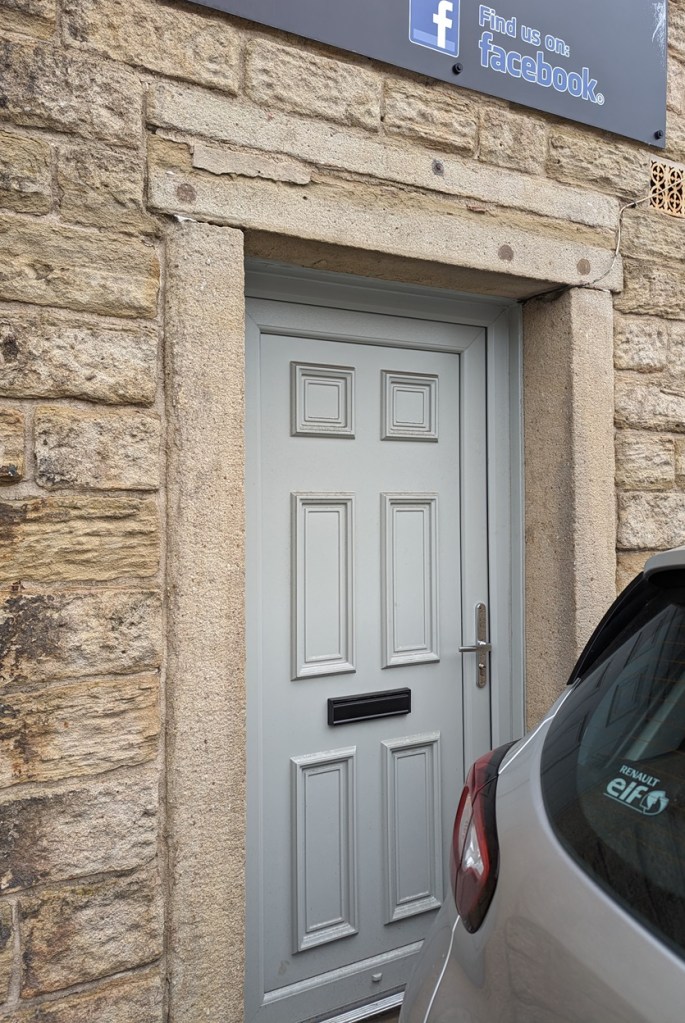
Next up and a little further down we have The Peartree Inn. Built in 1818, it was originally known as the Kings Arms.
Once you notice it, you can clearly see it was once a pub – symmetrical windows with a central door. Although, there is another bricked up door on the left, again perhaps the entrance to a separate room.The bricked up doorway up close. What was originally – I presume – the main entrance to the pub, and through George Booth and his party would have passed.And, o’ happy day, a bench mark! For those of you who don’t know, these were carved onto buildings to mark a specific measure height above sea level in the 1840’s and onwards. I love these things – the horizontal line marks the exact point, and the arrow below shows you where. This is exactly 504ft 7″ above sea level. Man, I love a bench mark! Check out this blog article, and many more like it in the archive.
It was here that in 1830 that the officers of a detachment of the 10th Hussars and 4th Regiment of Foot were stationed, being given the task of putting down a potential riot of spinners who were demonstrating in favour of a standard rate of pay. In 1832 it would have been owned by a John Woolley, himself an old soldier. We might safely assume they took one drink in the Peartree, although the chance of a chat with an old soldier… let’s say 2. It is a Grade ii listed building, with the official listing thus:
House, now offices and attached wall. Early C19 with late C19 and C20 additions. Coursed millstone grit with tooled dressings and stone slate roof. 2 stone end stacks. EXTERIOR: 2 storey and attic. Street front rendered. Almost symmetrical 2 window range. Off-centre doorway with C20 door in flush ashlar surround flanked by single plain sashes, above 2 plain sashes, all in flush ashlar surrounds. Left return has blocked tall opening at first floor level and above single plain sash. Right return has ground floor with elongated C20 window opening. Rear has C19 parallel extension with end stack. INTERIOR: not inspected. SUBSIDIARY FEATURES: adjoining wall to left has doorway in flush ashlar surround with plank door.
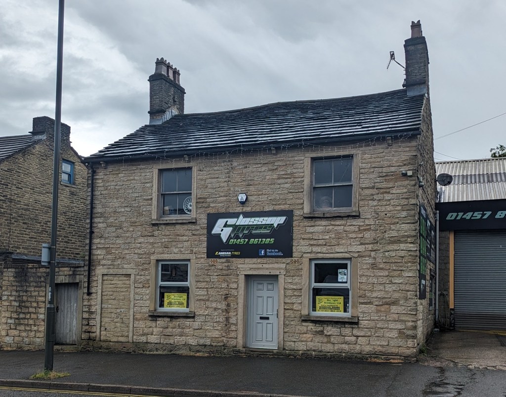
The Peartree ceased being a pub in 1926, and is now the offices of Glossop Tyres – make sure you check out the building the next time you are getting new tyres.
DRINKS CONSUMED: 6
Swaying slightly (we’ve all been there) they would have set off – it’s thirsty work, all this walking… Next up, the Howard Arms, for at least one.
Howard Arms, Ellison Street in the foreground. Again, like the Peartree, it was originally symmetrical, with the door central between the two ground floor windows. It was bricked up when the pub expanded into the building next door sometime after the 1930’s. That is the one George Booth and party would have used. A view of the Howard Arms in 1904, central door still in situ. The person in the doorway is likely to be the wife of John Green Hudson, landlord at that time. Image from the always excellent Glossop Victorian Architectural History site – HERE. Well worth a browse as it is full of old images, and catalogues our extensive and important Victorian heritage…. it really is an important website.As it is now, and after the windows were widened – still 3 light, only wider.
Named after the Howard family, the Dukes of Norfolk, it was built in 1800. It is superbly situated for passing trade, being at the crossroads of the old Woodhead Road (now Ellison Street) and the turnpike road running east-west, later expanded into the Snake Pass. Indeed, the trustees of this road building committee held their first planning meeting here, on 4 June 1818, and celebrated its opening four years later with a slap-up meal in the pub. A very nice establishment (possibly), I feel certain that more than one was consumed here. For one, he was already 6 drinks into this adventure, and at this point, the genie is hard to push back into the bottle, and trouser-ripping and umbrella-breaking are all but inevitable. But I also get the impression that he is having a good time, despite the shame he felt the next day, and the diary makes it very clear “we did not forget to call at each place“.
DRINKS CONSUMED: 8
From here, the party would have headed further down, and into the Norfolk Arms. Built in 1823, there is quite a bit that can be said about the pub, but I feel here is not the place – this is Mr Booth’s time to shine – so I’ll keep it brief. Built in 1823 as part of the monumental shakeup of this area, and the creation of Howard Town, The Norfolk Arms has been much altered and expanded over the years, especially in the late 19th century, but at its core it is another example of that neo-classical ‘symmetrical with a central door’ that define so many purpose built pubs of the late Georgian/Early Victorian period (the front porch is a later addition).
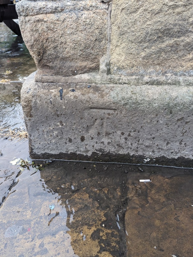
Apologies – this shot is taken from Google Maps’ Streetview. I took several photos of the building, from several different angles… but for some reason, none of them came out ok. Odd, but there you go. I’ll update the photos later, but for now I just want to get the article out there! You can see the central, ‘symmetrical’ building, with the later wings added. Oddly, this is the only photograph that worked properly! The bench mark on the south-eastern corner of the building marking 497ft, 1″ above sea level.
It is also slightly grander than many of the other examples – larger and more formal, it was also used as the town’s post office in the 19th century, as well as the coaching inn, where stage coaches between Sheffield and Manchester would stop. The Norfolk Arms is a Grade ii listed building, with the official listing reading thus:
Coaching Inn, now public house. 1823, altered late C19 and C20. Coursed millstone grit with ashlar dressings and hipped Welsh slate roofs. 4 ridge stacks and 3 wall stone stacks plus 2 louvred vents to left. PLAN: double-depth. EXTERIOR: 2 storey. High Street front has 7 windows arranged 2:3:2. Slightly projecting 3 window centre has central stone, flat roofed single storey porch with blocking course, plain square columns and C20 margin light glazing. Flanked by single plain horned sashes, above 3 similar windows. Wings have 2 similar sashes to each floor. All windows have painted ashlar lintels and sills. Left return has doorway in flush ashlar surround with overlight and to left single small then 2 large casement windows, above 3 plain horned sashes. Right return to Norfolk Street has central doorway under single storey flat roof porch with dentilled cornice supported on square Tuscan Doric columns, moulded round arches with moulded imposts and stressed keystones. To left single plain horned sash and to right large former shop window with former doorway to left and 3 round headed lights to right within plain pilaster surround with moulded fascia board. Above 3 plain horned sashes and small inserted casement window.
And it’s difficult to argue with that! The landlord in 1833 was a Joseph Oates, and I think they had single drink in here, as they decide to call it a night and head home.
DRINKS CONSUMED: 9
The diary states that they went via “Bridge End“, which means they would have crossed what was then a new bridge, but not yet Victoria Bridge. This whole area was in flux at that time, with new road layouts and buildings going up, and it may well have resembled a building site. However, there was one shining beacon on this dark and lonely road out of Glossop, one place of refuge and light. And beer; The Albion Hotel (also known as The Trap, The Last Orders, and now The Brook Tavern), which in 1833 was brand new, being built the previous year. Maybe just one more…
The Brook Tavern as it is now, originally The Albion. The porch is a later addition, but would have originally been like our other pubs so far, symmetrical with a central door.
Set back from the modern road now because it sat on the original line of the road and bridge (and lines up with Smithy Fold and Ellison Street), it would have been a magnet for the party – to celebrate crossing the bridge, and one for the road. The last. No more… “Ah, go on then, let’s have another…” The landlord at the time would have been a Charles Calvert, who by this point would probably have been glad to see them go!
The original line of the road can be seen by looking along the shop fronts here – they pinpoint the site of the original bridge, and Ellison Street beyond. The new road curves more to the west, over Victoria Bridge.
TOTALDRINKS CONSUMED: 11
And so, singing hymns – and other, less saintly songs – our party staggers into the night, and into infamy. Blimey… 11 drinks! Not bad for a Sunday session, and certainly more than I could do anymore. The ‘pub crawl’ is a brilliant piece of social history, a glimpse into the personal life of a person whose public life was probably very different, possibly very austere and proper – so the idea of him getting squiffy on a Sunday is amazing if, as he notes, shameful, as the sobering up starts, and he fits back into his public persona.
Now, here is also something of a question mark. His diary records that they went via “Bridge End Juncksion, Simondly“, but that is an odd way of putting it. Bridge End is Victoria Bridge, but it is not in Simmondley. Whitfield or Glossop, depending on which side you are standing (I get the feeling Bridge End proper is on the Glossop side of the brook), certainly, but not Simmondley – that’s over the water of Long Clough Brook. There is Bridge Field, which is just in Simmondley, but it is much further away. No, I suspect he may simply be confused: a bridge over water from Glossop… that’s Simmondley. Plus, he’s a Chisworth/Charlesworth man out of his territory, he may not have understood the finer points of local geography. And let’s not forget he was also somewhat impaired, mentally, by the time he arrived there!
So then, the ‘Juncksion’? A junction, or a meeting of roads. But from where? This is where Glossop’s history gets murky… and interesting. It is a dispersed settlement, with farmsteads all over, all of which feed into the centre – Old Glossop. Because of this, trackways spread spiderweb-like all over, connecting all of these places and people. A crossing point like Victoria Bridge – or rather the bridges that were there before – were naturally targets, focal points attracting all the tracks, as ways to cross Glossop Brook, would not have been common. Here on the map is shown the tracks. It should be stated that not all would have been in use simultaneously, they would have been introduced as needed; a new farmhouse built, perhaps means new tracks are made – but all heading for the single focus of the crossing point, the bridge.
The tracks that meet at Victoria Bridge. Pink: Victoria Bridge, Red: from Ashes, Green: from Simmondley (the main Simmondley to Glossop track, and which becomes Bank Street [The Bonk], Blue: from Whitfield, Yellow: the track to (Old) Glossop, Dark Green: the track to The Heath, and on to Padfield, but also Woodhead, and ultimately Yorkshire. A Juncksion indeed.
This article owes a huge debt to the book History in a Pint pot by David Field – a brilliantly detailed look at all of Glossop’s pubs, past and present, now sadly out of print and ridiculously difficult to get hold of. The library has a copy, so go there and read it. I’d also like to thank George Booth, especially as this is the second article inspired by his diary. I also feel slightly bad about lampooning him, however good natured it might be; after all, the shame he felt at being drunk was real enough to write about it in his personal diary. By way of an apology, I might raise a glass of the stuff that cheers his way tonight… although I’m not sure he’d approve.
However, I’m genuinely half tempted to recreate this monumental pub crawl – starting at the Royal Oak, and finishing in the Brook Tavern… and celebrate the end by tearing a pair of trousers and breaking an umbrella? Who’s with me? 21st of July this year is, coincidentally, a Sunday, but I feel that we live in less civilised times, and those of us who work will not appreciate waking up Monday morning. We could do it the day before – Saturday 20th. Just a thought… let me know what you think.
In other news, Where / When issue 2 is selling like hot cakes, which is great as it means that I can publish Where / When 3 relatively quickly. I also have some archaeological/historical walks planned for the summer – essentially me doing a Where / When live, with a bunch of you, if you fancy. And perhaps incorporating the inaugural George Booth Historical Stagger? But honestly, watch this space as lots is being planned…
Until the next time then, good people of Glossop – and beyond – please look after yourselves and each other.
What ho, dear and lovely people, what ho! I trust you are all enjoying the weather as it bounces, somewhat insanely, from parched desert in the midst of an African heatwave to “quick Mrs C-G, gather up two of every animal you can see, whilst I look up ‘How To Build an Ark‘ on YouTube” rainstorms. I mean, it keeps you on your toes, what!
So then, I have recently become obsessed with fields and their shapes, and what they can tell us about the history of Glossop. I know, I know, I really am quite the hit at parties! Indeed, I often hear the phrase “oh great, TCG has arrived!”… it’s nice to be appreciated. As an aside, 7-year-old Master C-G has recently taken to mocking me by asking a question about, for example, pottery, and then interrupting the answer with “wow dad, that’s soooo interesting…” and walking off, before falling down in fits of laughter. I mean to say, that’s a tad off, what? Where’s the blighter’s respect for dearest pater?
Anyway, where was I? Oh yes, field shapes and history. So, if you look at any OS map, you’ll see that it is criss-crossed with lines which mark out the boundaries of fields. On the ground and in real life these boundaries are made up of fences, hedges, or, in this part of the world, with drystone walling. It takes time and effort to build these walls, and more time and effort to take them down, which means it doesn’t happen very often. And unless the area has been significantly changed or has been built over completely, the field boundaries you see on the map and on the ground have been there since they were laid out. And here it gets interesting: the way fields were laid out changed over time – their shapes reflecting contemporary farming techniques – and it this which allows us to date them and their associated settlements.
Looking at local examples chronologically then, we start at the beginning. Quite literally. The first farmers – those neolithic & bronze age types who initially took the huge risk to cease the hunter-gatherer nomadic lifestyle, and instead adopt a sedentary one based around agriculture – created the first fields. Evidence from elsewhere suggests that these were not fields as such, more areas of land cleared of trees – a formidable task using only stone or at best bronze tools – and the area cleared of stones to enable to plough to pass. The larger stones are normally found rolled to the edges of the cleared areas, and there are often clearance cairns associated with them – piles of rocks, essentially. There are suggestions of bronze age systems in the area, but nothing even close to definite, and certainly nothing worth describing.
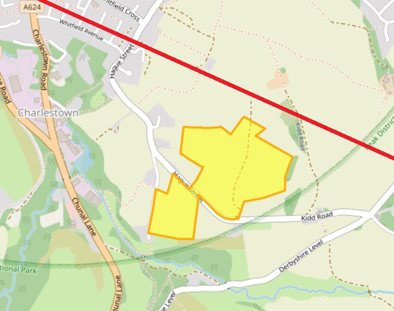
There is a similar situation with the Romano-British field systems, of which there is one possible example, in Whitfield, to the north and south of Kidd Road. These seem to comprise a series of lumps and bumps in the ground that might be the remains of field boundaries, or of terracing on which agriculture took place.
The potential field system is in yellow, the Roman road from Navio is in red. Image stolen and altered from the Derbyshire HER website.
As the Roman road from the fort at Brough (Navio) runs just by there, it would be a good place for a farmstead, and I’m sure more existed nearer Melandra. It’s not terribly inspiring, if I’m honest, but it is interesting, and if it is Romano-British in date (43AD – 410AD, perhaps a little later, too… or possibly a little earlier), then it is proof that people have lived and farmed in Whitfield for over 2000 years. You can read a bit more about it on the Derbyshire Historic Environment Record here, or, the Glossop & Longdendale Archaeological Society website, here.
However, our first definite and recognisable field systems occur in the medieval period.
By 1086, Longdendale and Glossop had been designated Royal Forest, a situation which brought with it all sorts of restrictions for the residents of the seven villages that made up the area at the time of the Domesday Survey: Chunal, Whitfield, Charlesworth, Hadfield, Padfield, Dinting, and Glossop (I’m convinced there was something at Simmondley and Gamesley at the time, but were overlooked or ignored as too small to tax). It was particularly particularly restrictive around land use; the existing villages were allowed to continue, but were not allowed to expand their size in anyway, as this would affect the king’s land, and take food from his deer. That didn’t stop them, though. What few records we have of medieval Glossop make mention of the crime of assarting, that is to cut down trees to enable the land to be used for growing crops or grazing – essentially increasing your land, illegally. For example, in 1285 we find the following:
“The wood of Shelf has been damaged in its underwood to a value of 15 shillings by the villagers of Gloshop, fined 4 shillings, they must answer for 60 oaks”.
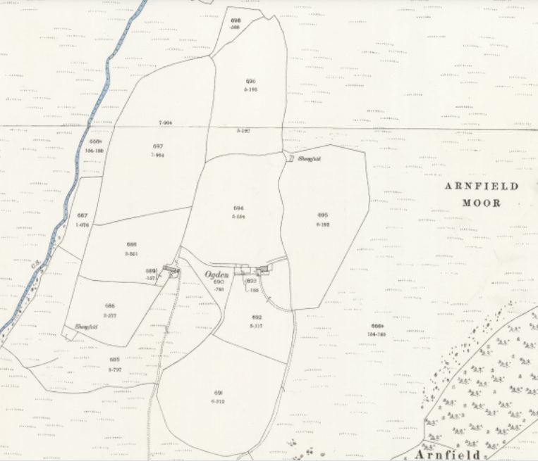
The process would have been gradual, and probably done sneakily, perhaps by bribing the forester to look the other way. Or equally, it may have been worth the fine if you can increase your farming lands significantly – an investment of sorts. Given the nature of assarting – essentially picking away a few trees at a time – it often leaves a distinctive field shape: rounded, rather than straight or uneven lines. There is a perfect example of this at Ogden, above Tintwistle:
The two farmsteads of Ogden, both now in ruins. I need to explore up there sometime.
And if we look over at Hargate Hill, between Charlesworth and Simmondley, I think we can see a similar process happening here:
Rounded edges, rather than the more usual straight.
The circular, almost organic growth of the fields can be seen, and it may be this that is referred to in 1285: “The wood of Coumbes (Coombs) has been damaged by the people of Chasseworth (Charlesworth), fined 2 shillings, they must respond for 18 oaks.” This whole area is full of interesting detail. The first mention of Hargate Hill I’m aware of is 1623 (the record of the burial of ‘Widow Robinson’ of Hargate on 10th July, to be precise), but there must have been something there before this date. There is a suspicion that stone from the quarry here was used to build Melandra Roman fort, although how true this is, is not clear, but the settlement is just off the main road between Glossop (via Simmondley) and Charlesworth, which is significant. Importantly, between the road and settlement, there is evidence for Ridge and Furrow ploughing, which is normally medieval in date. You can see it in this LIDAR image:
The ridge & furrow is running roughly north-south from High Lane.
Ridge and furrow is created by ploughing up and down a strip of land using a team of 8 oxen. Now, as you can imagine, 8 oxen are a nightmare to turn, and their size alone means that you have to start the turn very early on in your plough furrow in order to maximize the land use. This creates a distinctive reverse ‘S’ shape to the thin fields – or ‘selions’ – that make up the medieval farm landscape – the result of only being able to turn the oxen to the left (as the medieval farmer used a fixed blade plough share that was positioned on the right). These selions are side by side, with a dip in between (you can just about make out the dips in the above LIDAR image), and made up of rows and rows of ridge and furrow running the length of the selion. A selion normally measured a furlong in length (a ‘furrow long’: some 220 yards) and between 5 and 22 yards wide.
In Whitfield there are many great examples of this classic, and instantly recognisable, early medieval field shape.
Clearly visible, running NW-SE, and on either side of Cliffe Road. There are dozens more in dotted about the area, too.
Hiding in plain sight, the medieval field systems of the 12th & 13th centuries. The fact that they run either side of Cliffe Road is significant: they ‘respect’ the road, which means that the road was there before the selions, as it is highly unlikely a road would be put through arable land. We know this anyway – it was the main road from Glossop to Chapel en le Frith – but it is good to have it confirmed.
What I find amazing me is the sense of continuity of use; the field marked with a red ring in the above map is exactly the field boundary of the Whitfield Allotments, and I wonder how many allotment holders realise their plot of land has been continuously farmed for nearly a millennium. It’s also fascinating to think that although the area has been largely built over, the boundaries of individual modern house plots have used these field boundaries as references, and so the field laid out by a medieval peasant farmer 800 or more years ago has a direct influence on life today. Looking at a tangible history in that way leaves one feeling quite dizzy.
Chunal, first mentioned in the Domesday Book, was an important medieval farmestead.
Chunal is even clearer in its agricultural history, and has evidence of both assarting and the use of Ridge and Furrow on both sides of the road, especially what is hidden beneath the surface now – compare the above map with the LIDAR survey of the same area… huge numbers of selions, all in the classic reverse ‘S’ shape.
The same area scanned with LIDAR. The selions not shown in the above map are very clear.
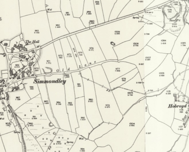
The quantity of field strips is testament to the relatively large-scale agriculture occurring in this area in the earlier medieval period. Simmondley, too, has a large number to the north and south of Old Lane, which was the original medieval track from Charlesworth via Simmondley to Glossop:
Notice the selions ‘respect’ the original track – Old Lane – they stop at the road, and don’t line up symmetrically on the other side. They are, however, overlain by the New Road which was built, I believe, in the 1860’s. Just as in Cliffe Road in Whitfield, Old Lane must have been there when the selions were laid out, or at the same time, giving us a date for the track.
During the 14th century, however, we see a shift in farming practice, and land use moves away from the ‘open field’ system of strips, and starts to become enclosed by walls. This is probably a result of two critical events. Firstly, the climate starts to get colder, which has a negative impact on the ability to grow crops, and which lead to a series of famines. The second was the emergence of the Black Death which killed off 1/3 of the population during 1348-49. And whilst the Peak District emerged seemingly relatively unscathed, no doubt there was a movement of the population to better arable land that had been abandoned, leading to a population decline. It had also become apparent by the mid century that sheep/wool farming was a lucrative market, and thus increasing amounts of land was blocked off to allow sheep to graze safely. These early enclosures are normally recognisable as non-symmetrical enclosures that have largely straight-ish lines, but aren’t a specific shape. We can see some probable examples to the north of Simmondley New Road, now covered by housing but preserved in the 1892 1:25 inch map:
Simmondley New Road running west-east(ish) replaced Old Lane… the clue is in the names!
If we look closely we can see these early enclosures are made by consolidating and expanding existing selions, as farming practice shifted from arable to livestock. The more you look, the more the medieval and early modern landscape comes to life.
We also encounter them at Gamesley, now also covered by housing, but perhaps originally associated with Lower Gamesley Farm which may have an early foundation date, even if the present building there dates from only the 17th century (only…!). The settlement is first mentioned in 1285, but actually Gamesley is a Saxon name meaning the ‘clearing (or assart) belonging to Gamall’.
Gamesley, to the south of Melandra.
Of course, people needed agricultural produce, and many strips continued to be farmed well into the post-medieval period. Indeed new fields were laid out, although later ridge and furrow is normally straight as, over time, smaller teams of larger oxen were used, and these were eventually replaced altogether by heavy horses.
Our final field type comes at the end of the 18th and early 19th centuries with the parliamentary enclosures. Briefly, open ‘common’ land – poor rough land, owned by the Lord of the Manor, but used by everyone to graze animals or to gather fuel – was parcelled off and sold in lots. On paper, this freed up lots of land and was a boon for farmers who could, with a little improvement, massively increase their lands. But it also meant that the common man lost access to land that his ancestors had legal rights to. Arguably, by the early 19th century there were very few people who would have used the land anyway; not many people had animals to graze, nor did many burn peat as a fuel. The rural way of life, especially in Glossop, was well and truly over and most people lived in stone terraces and worked in mills. But that really isn’t the point! The parcelling up of the land into lots was done drawing lines over maps using rulers… and it shows.
Moorfield is surrounded by fields that are the result of the 1813 Whitfield Enclosure Act.
And elsewhere:
The area to the north of Glossop
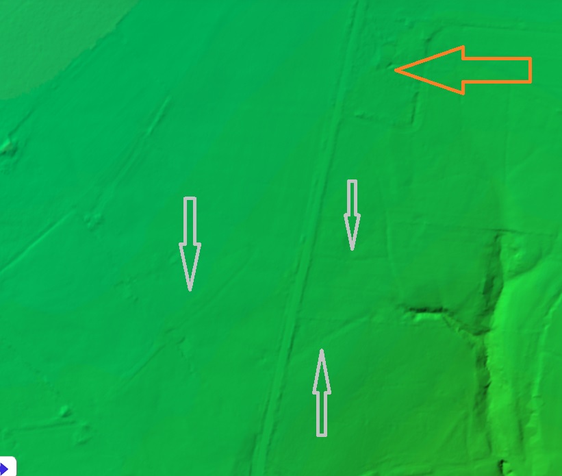
Around Lanehead farm, toward Padfield there are clear examples of 19th century enclosure… in fact they are all over Glossopdale – have a look at any map. They often mask earlier field systems and tracks which can be on a different alignment, and a quick scan of the Lidar for the same area reveals all sorts of lumps and bumps:
Lanehead Farm is shown by the orange arrow.
The grey arrows above show older field systems not shown on the map. In the middle of the arrows there is what might be ridge and furrow. A detailed study of the fields on the maps and on the ground, as well as a comparative reading of the lidar could give us huge amounts of information about the past use of the landscape, beyond the obvious parliamentary enclosures.
The lines of these fields are all very straight, and all the walls are of a standard form, and the whole parliamentary enclosure process was completed with characteristic Georgian and Victorian efficiency. But a part of me feels that it is almost an industrialisation of the landscape, a triumph of efficiency over nature. Prior to this, it was a difficult process to carve out a little patch of land to support your family, and it required blood, sweat, and tears. This human, organic, side is etched onto the land – assarting, the reverse ‘S’ shape, even the enclosures for sheep, they all have an element that is dictated to by the land, and all came with effort. To stand over a map with a pen and ruler dividing up the landscape is to have a complete disconnect from it, and is human imposing on it, rather than working within it, and that feels wrong somehow. Anyway, enough of the hippy!
It genuinely is amazing what you can see when you start to study maps, the unexpected can leap out at you. Keep looking, wonderful people, and please mail me with anything you find – I could even make you famous* by publishing it on the website.
*famous to all 11 people who read the website, that is.
Anyway, I hope you have enjoyed todays romp around the countryside. I’m planning a few more official Cabinet of Curiosities wanders over the summer, one of which is a jaunt down the medieval and early modern trackways of Whitfield and Glossop via 2 pubs and a pile of history and archaeology… what’s not to love? And all at a bargain price… a man has to eat, after all. Watch this space. Or Twitter. Or Instagram, if I can figure how to use it properly.
Until next time, keep looking down, but also look after yourselves and each other.
Nope, no pottery today. Instead we have tracks. And stones. And holes. Look, just read on… it’s simpler.
Now, I do love a good track. Ask anyone who knows me, and they’ll say “why yes, that ruggedly handsome, wonderously whiskered, and all-round splendid chap does indeed love a good track or two“. I also love a good stone. In fact, ask anyone who knows me, and they’ll say “why yes, that marvellous man, that genius gentleman, that… ” What’s that? What do you mean “get on with it!“? Honestly.
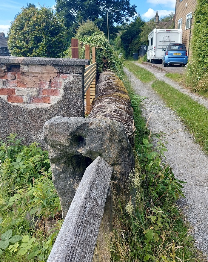
Ok, so several years ago I noticed that dotted around the Glossop area are a number of standing stones that have holes carved in them. I did wonder about them, but presumed they were a form of gatepost, even if they didn’t seem to be in a place one would expect a gatepost.
A holed stone on Hague Street. They remind a bit of Hattifatteners from the Moomin stories… they probably come to life at night.
More recently I have been looking at tracks:
TRACK (noun) A rough path or road, typically one beaten by use rather than constructed.
And more specifically, the old – medieval or post-medieval (10th – 17th centuries) – trackways that dotted the area. Glossop is a great example of what we call a medieval ‘dispersed settlement’ – essentially, whilst there is a central focus – Old Glossop, with the church and market – most people actually lived in the many surrounding ‘dispersed’ farmsteads – Heath, Dinting, Ashes, Jumble, etc. People came together every Sunday for Mass, as well as other feast days and holy-days, for market days, as well as socially – for a drink in the tavern, for example. But by and large, Glossop in the medieval and early modern periods was dispersed throughout the valley in farmsteads. In this instance, a farmstead may be understood as a farmhouse and associated buildings – barns, shippons, and various ‘farm-ey’ outbuildings – as well as houses for the farmworkers. In total, we’re looking at perhaps 20 people or so for a larger farmstead, maybe 5 for a smaller. Of course, people need to travel, and roads were made through the landscape, connecting these farmsteads, and it these I incredibly interesting.
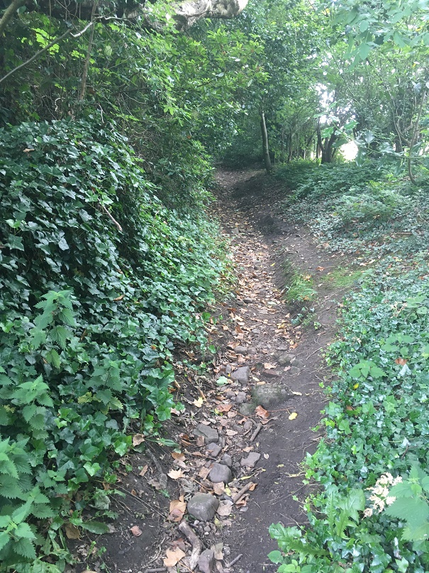
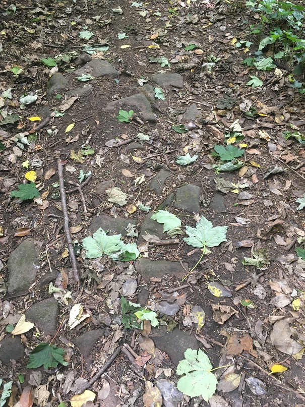
This is the track that runs down from Ashes to Dinting – once the main thoroughfare, now a beautiful sunken trackway, or holloway as they are known, its age is shown by its depth, worn through use.
They were not just a means of physical movement through the landscape, but also a conduit for other aspects of life. As packhorse routes (no horse and carts here, just heavily laden beasts of burden) they connected everybody, and allowed goods and produce to move between places and markets. News of the wider world also moved along these tracks – a new king or a new religion, or news of battles and wonders in far off places. But so did disease and infection; the Black Death and Great Plague once walked these tracks. We also encounter the more local and personal aspects of life, too: newlyweds from church, newborns from baptisms, and the final journey from the farmstead to the church yard, as the deceased was carried for burial, often for miles, along the tracks, followed by mourning family and friends. All of life is contained in a track, worn deep by use, and all of history held there, if only we could access it.
However, the collision of stone and track didn’t connect until last year, when it occurred with an audible click at Pyegrove.
Pyegrove circled in red. For orientation, the Snake Pass runs horizontally across the bottom, with the Commercial Inn on Manor Park Road circled in blue on the right, and the Royal Oak, left. Note the green arrow. Map from the marvellous and incredibly useful National Library of Scotland map website – well worth an explore.
An afternoon playdate with Master Hamnett and his friend led us to Manor Park via Pyegrove. Now Pyegrove is an interesting corner of Glossop, with a long history; the name means the copse or thicket’ (grove or greve, as it is in older maps) of the magpie (the ‘Pie’ or ‘Pye’ element) which suits its location below Shire Hill perfectly. The house here has a datestone that reads “I.M.A. 1747” (no photographs, alas… it’s difficult to even see it without overtly trespassing), so that the house is at least that early. However, in the baptism record of a John Shepperd at Glossop on Christmas Day 1735, his father (Robert Shepperd the Younger) gives his address as Pyegreve, so we know something else was there at an earlier date. Pyegrove is, I suspect, another medieval farmstead… but all that (along with tales of Buffalo Bill) is for another time. Let’s return to tracks and stones.
The footpath at Pyegrove splits – right skirts Shire Hill down to Mossy Lea, left ploughs on over the playing fields to Glossop.
Tarmacked, unlike the original, choose your path wisely.
But just at the split I noticed this:
Oooooh!, thought I – a holed stone…
It was at that point it suddenly struck me, and as I stood there gasping like a stunned fish, ignoring the children, and mentally ran over all the holed stones I knew about (5 at that point). Of course, I thought, they all marked a junction in a footpath or track! And all of those tracks, I was fairly certain (and am now convinced) were the preservation of early (medieval or post-medieval) trackways between farmsteads. I have talked about this before – the fossilisation of early trackways, preserved as footpaths within modern settings, but in essence once the newer – and much better – roads were constructed for the mills (1790’s onwards), these old roads fell out of use, but as they often were more direct, and were known by locals who still used them, they gradually became public rights of way.
The stones, being big and heavy, are often not moved, so there they sit as testament to the tracks that were once the main roads between the dispersed settlements that made up Glossop. I know of 9 holed stones now (and two more that might be relevant), and looking closely at the stones, they all share similar aspects. Upright, and roughly shaped from millstone grit or similar gritstone, and they seem quite worn – usually an indicator of age. The hole, made through the stone, is broadly square in shape, measuring between 3 and 4 inches across, roughly carved, and placed in the top third of the stone. I am convinced they were shaped and set up by the same group of people to make using the notoriously bad road system around Glossop easier. Of the stones, the obvious question is why does it have a hole in it? My first thought was that it would mark the stone as different from others that might be in the area, making sure that a junction wouldn’t be missed in the dark or bad weather. This might be the case, but then I remembered reading that in 1693 a law was passed that trackways had to have a guide post showing destinations (the Whitfield Guide Stoop was a result of this law, but probably a later incarnation), and I wonder if the hole was there to allow a wooden sign to be placed in it with destination painted or carved on it? Or perhaps a simple stick pointing the way? Any thoughts on this, o’ wonderful readers? I also wonder how far this tradition continues – certainly I know of no others in surrounding areas – even Tintwistle or Hadfield, for example, seem to have no holed stones, although I’m happy to be proven wrong. .
But let’s have a virtual explore the Pyegrove to Glossop track here, starting at the stone that started it all.
Ignore the later drilled circular hole, and the rusty bolt through the hole – this is a classic junction marker, with its ‘square’ hole and rough shaping.
Ignoring the A57/Snake Pass (opened in 1821, although bits are older), behind us is what is now Derbyshire Level, with the farmsteads of The Hurst, Jumble, and Gnat Hole, and also the road to Whitfield and Chapel en le Frith. Going left, then, a track along the edge of some houses leads out into Pyegrove Playing Fields.
Looking back at Pyegrove, the overgrown track hides what was once a main thoroughfare into Glossop. O’ for an excavation of this track!
Along the northern edge of the playing fields the track is no longer used, but is visible as a ‘holloway’ – a track worn deep with use.
Here is the Holloway, Green Way, or sunken trackway, depending on how you call it. Do you known what, it’s oddly difficult to photograph a dip in the field, but it is there… honestly!
We join the track again at the corner of the playing field, where there is a lovely squared off standing stone.
A simple standing stone, if such a thing exists.
This seems to mark the junction of a track that originates at Cross Cliffe, here marked in blue:
The trackway is visible in the older maps, and although it fizzles out on the ground, it is preserved in field boundaries and fossilised in strangely preserved bits of pathway.
Whilst it is just about marked on older maps, it is no longer in use, although its memory is fossilised in this bit of unnecessary and unusually wide stretch of pedestrianised path leading from the Snake Pass to Pyegrove Park (marked with a red circle in the above map)
Oddly wide, and completely unnecessary, this is the fossilisation of an older track from Cross Cliffe.
These simple – unholed – standing stones sometimes mark junctions, but more normally simply mark the line of a path where is might not be obvious, particularly in the dark or rough environment (I know of about 12 of these, too).
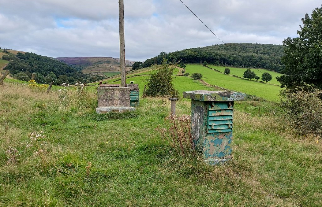
We continue along our Pyegrove track beyond the stone and past the remains of the Royal Observer Corps station. Briefly, the station was meant to monitor potential enemy aircraft in the immediate post-WWII period, but it would also serve as a monitoring post, observing and recording the effects of any nuclear detonation on Manchester – wind speed, radiation levels, blast radius, etc. This is why it is built into the hillside, 15ft below ground level. A sobering thought, and one sadly now relevant once more. This will also be the subject of a future blog post, don’t worry!
An interesting slice of much more modern history, but one that is certainly worth a look at .
Back to the task in hand, and on to another standing stone. This one, looking for all the world like a gravestone, was originally one of a pair (its partner is embedded, horizontally now, in the wall.
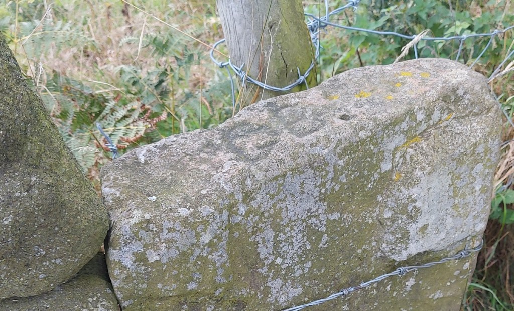
One of a pair – the other can be seen lying horizontally built into the wall – same stone type, same width, same depth, and presumably the same length, accounting for a few feet underground.
These gravestone pairs are usually found mid track or at the start of junctions, and seem to be a later addition to the tracks (probably post-1790’s) and seem to be an attempt to force packhorses and traffic onto the newer roads (and presumably so they can pay the tolls) – and early form of traffic calming, if you will. I am fairly certain with the date of c.1800 as Whitfield Cross was used as a partner to one of these ‘gravestone’ pairings after it was moved in about 1800. There is some graffiti carved on the top of this stone – ‘G.B.’.
G.B. step forward and take a bow – I do like a bit of carved graffiti.
From here we continue, round the corner, to the farmstead of Hall Fold.
Converted barn and outbuildings of the farmstead of Hall Fold
A datestone here records ‘J.S.J. 1806’, but this was apparently found when the owner was digging a foundation, and clearly Hall Fold Farm is older that that.
Not my photo – stolen shamelessly from the Old Glossop website, which has a bit of history and a series of very interesting photographs of Hall Fold Farm – here.
The name itself may refer to a long demolished, possibly medieval, original Glossop Hall (Manor Park Road was once known as Hall Street). This is also the location of a junction – our track is joined from one that comes from Whitfield (an extension of this one).
A fork in the track!
Our track from Pyegrove is on the left hand, but the one from Whitfield comes via Old Glossop Cricket Club, and would have come through the gates ahead. Though no longer in use, its presence is preserved in field boundaries and the fact that these houses (c.1830’s) respect the track, which is why they are built at that strange angle. It’s also visible in LIDAR under the cricket pitch.
Sadly, no marker stone remains at Hall Fold Farm (although I didn’t start poking around people’s gardens, and it may well be lurking somewhere – large stones are hard to completely lose). From here, the medieval centre of Glossop is a hop, skip and a jump… if you are feeling so inclined.
I have to say, though, walking into Glossop this way is a much more interesting – and authentic – experience, and one that is very different from walking along Manor Park Road! We take our modern roads for granted, and I’m not going to lie – the idea of moving along these tracks in bad weather and in darkness fills me with fear.
This is a small part of a much larger project I’m working on, tracing these tracks all over Glossopdale. Each of the settlements that make up ‘Glossop’ – from Wooley Bridge in the west, to Pyegrove in the east, Tintwistle at the north, to Chunal in the south – have multiple tracks linking them, and for the large part they are still there, often hidden, occasionally ‘fossilised’ as footpaths, or even still in use. This is truly an overlooked, and indeed largely undiscovered, aspect of Glossop’s pre-Victorian/pre-Industrial history, but one that was vital to its development. And I have to say it is great fun being able to walk these ways, and pondering the history they hold – if anyone fancies joining me, give me a shout. Also, and this is a serious request, if anyone knows of any holed stones (or any standing stones, for that matter) that I might not know about, please do get in touch – often half hidden in hedgerows, they will lurk where two or more tracks join.
Right, that’s all for now. More pottery next time (did anyone else hear that high-pitched screaming sound?), but until then look after yourselves and each other, and I remain,
So, despite having half a dozen half-written posts, piles of interesting objects and sherds to talk about, and a few adventures to recount, I want to try something a little different today. “Oh no!” I hear you cry. But fret ye not, gentle reader, for it is still archaeology, it is still Glossop based, and it is still interesting. But it is a little… quirky. You’ll see what I mean.
I have a friend who is a writer, and quite a good one at that. He has often mentioned that stories usually start with what he terms a “What If?” moment, where something – often an object – presents itself, and the question is posed “what if…?” From there the story grows, based on and around that one question. The answer that comes doesn’t have to be ‘real’, it is fiction after all, but it has to be possible. What if a house was haunted? And what if the house fell down? And what if a brick from the house was haunted too? And what if a dashing archaeologist took the brick home to write about it on his extremely popular and incredibly interesting blog? What if…?
Archaeology, I think, uses a similar technique. An object is excavated, and the interpretation – the story – begins. However, where we differ from writers is that we base our ‘what ifs…?’ on evidence and supposition grounded in data. The interpretation, in this sense, has to be ‘real‘, although it is only ‘real’ for as long as the data supports it. Sometimes though, It’s fun to play “what if…?” – and here we join today’s post.
A stone head displaying all the characteristic features, including almond eyes. This one was allegedly found on Mouselow, and now lives on a wall in Buxton Museum
Stone heads. A lot has been written about them. They are cursed and evil. Or they are warm and friendly. They are ‘Celtic’ (i.e. Iron Age or Romano-British) in date. Or they are medieval or early modern in date. Or a combination of both. They represent an unbroken pre-Christian tradition, and an aspect of the whispered ‘Old Ways‘. Or they are simply folk art, and just decorative. Or they are magically protective (that wonderful word, apotropaic, again). Or both. Or neither. A brief trawl of the internet gives a lot of different sites and opinions, ranging from the scholarly and the more open minded, to what can only be termed outright nonsense.
Whatever they are, carved stone heads are a feature of this part of the Pennines – from Longdendale, over the hills to West Yorkshire, and up to the Calder Valley. I actually have a serious project that is looking at them; cataloguing known examples from Glossop and Longdendale, and trying to place them geographically, as well as giving some sort of date to them. There are at least 23 examples from the Glossop area, with more doubtless waiting to be uncovered. But it’s an ongoing project, and not really ready to publish – here, or anywhere else for that matter – and I just keep chipping away at it. It was during the course of trying to map where they were found, that I noticed something very interesting.
Stone head in Old Glossop. Image stolen shamelessly from the Old Glossop website (follow this link – the website is very good)
Before we go any further, I should state that my personal belief is that most of the stone heads are medieval or post-medieval in date (indeed, there is a record of them being carved in the 19th Century). That’s not to say that Iron Age ‘Celtic’ examples don’t exist (one was found at Binchester Roman Fort, in County Durham in 2013), it’s just that it is very difficult to date them as they usually don’t come from any secure archaeological context, and basing a date on ‘style’ or method of carving, as has happened in the past, is notoriously dodgy. That stated, there is the possibility that I might be wrong. And this led to my ‘what if…?‘ moment.
Back to the find location, sadly the majority of the heads are simply “found in Glossop area“, and thus have no exact place. But from various sources, I was able to identify where some of the heads were found. The distribution map is below:
1:10,000 map of Glossop. The Find spots – where the heads were found – are marked in red.
They seem to be dotted all around the area: Mouselow, Manor Park Road, several in Old Glossop, etc. However, looking at the above map, I noticed there was a distinct grouping in Whitfield – four of them centred around Slatelands Road and Hollin Cross Lane. Hmmmmm… let’s have a closer look, then.
Here is the Whitfield group on the 1:2500 map.
Duke Street, Pikes Lane, St Mary’s Road, and Slatelands Road. Geographically, they are in the same tangle of roads in that area. But the heads more than likely pre-date the Victorian roads, so we need to strip them back. What was there then? Well fields, mainly, though the medieval track from Simmondley to Glossop ran through here (that blog post is coming, I promise!). And before that, the Roman road also ran through here, along Pikes Lane, before kinking over Long Clough Brook and onto the fort and settlement at Melandra.
And then, the “what if…?” hit me.
For the sake of a good story, what if these heads actually were Iron Age or Roman in date? What could this cluster mean?
Looking again at the area stripped of the Victorian houses, it’s very clearly a promontory, a high plateau that runs between two brooks – Glossop Brook to the north, and Long Clough Brook to the south. In the Iron Age, they liked their elevated places – Mouselow, which dominates the area, is a classic Iron Age hillfort, and others exist nearby, at Mellor and Mam Tor. One only has to look at St Mary’s Road from Harehills Park to see how steep those slopes are (try doing it pushing Master Hamnett in a pram with a load of shopping from Aldi). And on the other side, who hasn’t cursed Slatelands Road halfway up, gasping for breath. This is a very real landscape feature, completely masked by later development, but one which would have been very visible back then. This would have been particularly true where the peninsular narrows at the west, leading down to the junction of the two brooks. This too, is significant.
Throughout prehistory water was a sacred thing, and was considered ritually important. A spit of land, elevated, defined by water and ending in the confluence of two bodies of water, would have been hugely significant. Actually, a perfect place for an Iron Age temple or shrine, perhaps one devoted to the ‘Celtic head cult’ as suggested by scholars such as Dr Ann Ross (in her Pagan Celtic Britain)? Indeed, the North Derbyshire Archaeological Survey notes that the number of heads in the Glossop area “might suggest a cult centre” based in the town in the Romano-British period (Hart 1984:105). It has been suggested that the heads are sometimes associated with liminality and boundaries, and were protective. What if they were they placed facing down the peninsular, to mark out the sacred space, and to defend it?
The Roman road moves through this promontory, sticking to the high ground away from the valley floors and marshy terrain, as the Romans preferred (see map below). But what if the location of the possible shrine or temple influenced the choice of road location, ploughing through the sacred enclosure, perhaps to make a point about Roman dominance?
The location of the heads in relation to the landscape. The blue is the waters of Glossop Brook (north) and Long Clough Brook (south), forming the spit of land. The yellow line is the medieval trackway, and the green line is the course of the Roman road.
What if…?
Now, I’m not suggesting for a moment that that the above is absolutely true; this is a wild flight of fantasy, and pure fiction – a story. Indeed, doubts are being raised about the reality of the ‘Celtic head cult’ theory in general. But it is a possibility, at least: an archaeological what if…? However, if that isn’t the answer, there still remains the issue of why four stone heads were found in a cluster in this area. What is going on?
If we return to my original thought, that the heads are medieval or post-medieval in date, might they be related to the Simmondley – (Old) Glossop trackway in someway? If we look at the map above, we can see this track (marked in yellow) runs broadly along the line of Princess Street. And just to the east of the three of the heads run along the same alignment. Is this significant? What if people somehow, and for some reason, deposited these heads to the east of the track? But why? Well, I came across a possible reference to just such a practice in this area – Clarke states that “Oral tradition in the High Peak of Derbyshire suggests heads were buried as charms beneath newly-built roads, presumably to keep permanent watch over them” (1999:286). He cites no sources for this “oral tradition”, but this type of apotropaic function – preventing witchcraft and promoting good fortune – is associated with carved heads all over the United Kingdom (Billingsley 2016). Perhaps, then, we are seeing the ritual deposition of carved heads as part of the road building tradition.
What if…?
A pair of Whitfield Heads. These are at the end of Kershaw Street… and that is all I know about them. It’s on my ‘to do’ list, don’t worry.
No, it is a mystery, and ultimately we are left with questions for which there are no obvious answers. Three of the heads are in Manchester Museum, and the fourth presumably in the hands of the owner/finder. I will have to go and see them, as that might help in dating. As I say the project is ongoing, and any comments or help in the area would be greatly appreciated. Do you know of any stone heads? Do you have photographs of any? Or stories – they seem to attract folklore and superstition like nothing else! Please contact me in the usual way – email me, or through twitter ( @roberthamnett ). Or just come and find me in the street, as people are increasingly doing… so much for pseudonyms and anonymity!
I do hope you enjoyed the little flight of fantasy, but we’ll be back to business as usual next time – the sherds are mounting up! Until then, look after yourselves and each other.
And I remain, your humble servant
RH
References:
John Billingsley – Instances and Contexts of the Head Motif in Britain
David Clarke – The Head Cult: Tradition and Folklore Surrounding the Symbol of the Severed Human Head in the British Isles. (Unpublished PhD Thesis, accessed here)
Anne Ross – Pagan Celtic Britain: Studies in Iconography and Tradition
(well, it is here and now, but I suppose it depends on when you are reading this… in which case, feel free to substitute “evening” for whatever part of the day you happen to be reading this.)
Perhaps I should start again.
What ho!
A short one today – I realise that I haven’t been as active as I’d like, so rather than labour over a larger post, and as a sort of proof that I’m still alive, I present today’s smaller offering – the area of Glossop known as Bridgefield. This is a place you drive through without ever noticing it is there – blink and you miss it as you go from Charlestown to Dinting along Primrose Lane. It is also a great example of why maps are so useful as a record of places – without it being drawn on the map, it is likely that Bridgefield would have ceased to be remembered as a place at all.
I have commented elsewhere that older names for places are usually based on reality, and reflect a different set of priorities – largely truthfulness in description: Gnat Hole was not named ironically, and so it is with Bridgefield, it was – and is – the field with the bridge. Well, actually bridges, plural – there are two. The first is where Primrose Lane crosses Long Clough Brook, circled in blue on the map below. But it is the second one – a small footbridge over the Long Clough Brook – that I think is the more interesting of the pair, and is indeed the older. Moreover, it actually is in the ‘Bridge Field’, rather than two fields over. And so, this humble little bridge is the target of today’s fevered ramblings. The bridge, or to be precise an earlier incarnation, is circled in green in the map below.
A rather colourful rendering. The bridge of Bridgefield is marked in green.
It crosses Long Clough Brook at the bottom of Slatelands Road, and now forms the bottom end of a footpath from Pikes Lane, emerging into Primrose Lane. This track – marked in red in the map above – wends its way between houses and land, and is known locally as the Chicken Run; indeed it still has chickens at the bottom. It was also known as the ‘Giggle Gaggle’, apparently, which recalls strongly the ‘Gibble Gabble’ in Broadbottom – another track that wends its way between houses and land. Indeed, it is suggested that Gibble Gabble (and thus Giggle Gaggle) is a localised (Mottram, Broadbottom, Glossop) dialect name for what is known elsewhere as a ‘ginnel’ (a track that wends its way between houses and land), which makes sense (here is a little more on the subject). According to A Journey Through Glossop by Kate Best and Owen Russell this same trackway was also known as Burneen by the nuns of the convent on Shaw Street, who used it to get to Hobroyd.Burneen is a version of the Irish term, Boreen, which means… anyone? Anyone? That’s right – a track, usually one that wends its way between houses, etc. There is a theme here… if only I could spot it. David Frith in his Pathwise in Glossop and Longdendale (p.60, Path 40) notes that this path went through allotments, and was known as the ‘Flagged Fields’, again strongly suggestive of a maintained trackway or road.
Joking aside this track is very important; I am convinced it forms part of the medieval road (such as it was) between Charlesworth, via Simmondley, to (Old) Glossop. The track goes along Old Lane in Simmondley (the name is a clue), down a sunken trackway that might indicate both age and heavy use, and emerges along another ‘fossilised’ footpath, preserving the original trackway ‘in stone’ – here, at the bottom of Simmondley New Road and Moorside Close:
The tail end of the track that comes from Charlesworth via Simmondley (Old Lane).
It continues along the footpath until it meets Pike’s Lane. This track will be the subject of a future blog post as it is a vital part of the history of the area, and well worth an explore, but for now let’s return to the bridge. Here it is, then, the current bridge of Bridgefield.
The bridge over the brook.
This bridge is quite modern, being made from rolled steel ‘I Beams‘, and it is clearly the latest in a long line of bridges of various sorts.
It works as a bridge, but it’s certainly not romantic.
We may assume that the earlier bridges were made from stone in one form or another, but looking into the brook, I noticed some large flat stones – much bigger and more substantial than paving slabs – that look out of place.
They’re not easy to make out, but the slabs are dotted along this stretch of Long Clough Brook, directly below the bridge. Incidentally, the Brook marks the border between Whitfield and Simmondley – as we look at the photo above, Simmmondley is on the right, Whitfield left.
Am I wrong to imagine that these once might have made up the medieval and early modern bridge in the form of a Clapper Bridge? The stones having fallen, but not moved very far by man or water.
A Clapper Bridge. This example is at Postbridge in Dartmoor, but they are a common way of forming a river crossing, especially where the banks are high – as they are at Bridgefield.
If I’m honest, I probably am wrong; the whole area has been extensively messed around with by the building of mills and mill ponds, as well as work on the brook itself with the building of weirs and shaping the banks. It’s difficult to get an idea what the area would have looked like, and it’s unlikely that any vestiges of the original bridge remain. But still, let’s imagine.
EDIT
Actually, further evidence to support the Clapper Bridge idea might be suggested by the fact that Slatelands Road, which runs down to the bridge, was once known as ‘Stoney Causey‘, the Stoney Causeway. The word ’causeway’ normally indicates a raised roadway across wet ground, as opposed to a bridge per se. which would fit quite nicely.
However, the importance that was once given to Bridgefield is underlined by the fact that the Reverend John Wesley, the founder of Methodism, preached here. Now, that Wesley preached in Glossop is not in itself big news – he preached all over, favouring the open air, and had a fondness for this part of England, returning time and again to spread the word of his particular brand of Christianity. But the fact that he chose Bridgefield as the location for the crowds of people that would have gathered – some jeering and making mock, others listening intently and converting – is significant. It indicates that this was an important place, and vital in communicating between towns – Glossop and Charlesworth/Simmondley, but also one that was well known enough that people all over Glossop would come and hear him. In his diary, Wesley records the following entry:
Friday, 27th March 1761 “I rode to Bridgefield, in the midst of the Derbyshire mountains, and cried to a large congregation, “If any man thirst, let him come unto me and drink.” And they did indeed drink in the word, as the thirsty earth the showers.”
Well there you go. Who knew that this often overlooked corner of Glossop had an interesting history. As I say, I’m going to blog about the Charlesworth to Glossop track in a future post as it’s a hugely important thing, and part of a larger project that is trying to identify all such trackways in the immediate area. I also recently did some mudlarking in Long Clough Brook, so should probably post the results.
Right, until next time, please take care of yourselves and each other.
As I have said many times before, I do love alliteration. What ho! and all that. I trust you are all keeping well in these odd times? Well, now this is a monumental post – it is precisely three years to the day that I made the first post on this blog (you can read it here if you want). When I first started it I had no idea what it was going to be, other than I had some interesting bits and pieces that I wanted to share, and which I thought other people living in Glossop moght be interested in. The blog is still pretty much that in aim – bits and pieces – and I was right… there are lots of you out there who seem to enjoy the ramblings of a man who gets excited by bits of old rubbish. So thank you, you wonderful people, for reading, and here’s to many more blog posts. Now, on with the show. RH
During the lockdown, Master Hamnett and I have been taking a daily constitutional up and around what has become known as the “secret passageways”. Overgrown and wild in places, even for a man of modest size such as myself it is a mysterious place, but to a 4 year old it is indeed another world. Naturally, I have been keeping an eye open for bits and pieces of history, and I think I have a story to tell. Possibly. Well, I certainly have some pottery to show, so there’s that!
The route we walk is essentially along Hague Street, down one track to Charlestown Road, along, and then up another back to Hague Street. We often continue on and round if it’s not raining, but always walk these paths, which I have helpfully marked Tracks 1 and 2 on the map below:
Tracks 1 & 2 at the top. Ignore the arrow and a circle for now… all will become clear!
The tracks and immediate area are more clearly shown on the 1968 1:2500 map
It’s a nice and short circular walk, if anyone fancies it.
The tracks are interesting in themselves in that they are once again an example of what I call the fossilisation of trackways – they are older tracks that no longer perform a function as such, but are preserved as footpaths. Certainly in this case as it makes no sense to have two tracks mere metres apart going between the same places. Instead, I think they are preserving the memory of a single older track, which I suggest below is Track 2, potentially the more interesting of the two. But I’m getting ahead of myself.
Track 1 runs down the side of this house, which was originally a pub called the Seven Stars (hence the sign on the door frame, although the sign above the door is a mystery… if you are reading this and own the house, could you tell us?).
The one-time Seven Stars pub – I always feel a bit weird photographing people’s houses, but this is visible from the road, so it’s not as though I’m sneaking around gardens.
I know nothing about this establishment, but it was probably a beer house. As a reaction to the widespread and dangerous consumption of cheap gin – the so-called ‘Gin Craze’ of the late 18th century – the government encouraged more beer drinking (beer being considered relatively healthy) by allowing householders to open up their houses to brew and sell ale. These private houses became known as beer houses, and the individual paid a small fee to the local magistrates in return for an annual license allowing them to sell beer, but not the wines or spirits that the normal pub or inn could. If anyone has any information about the Seven Stars, please do get in contact.
Just here is a series of upright stones presumably placed to stop horse riding or cycling. The gap between them is very thin; I might have put on a little weight during lockdown, but even I had to squeeze through.
Breath in!
Carved onto one of these uprights are the intials ‘M.D.’ – I must have walked through these 100 times and never noticed the letters before, but the light and the rain were just right this time.
And as you all know by now, I can’t resist carved graffiti.
Further down the footpath I noticed a reused quern or grind stone – possibly Victorian, but I suspect earlier – being used as a coping stone for the wall. And why not? It’s the perfect shape, and may well have been hanging around for centuries after being used to grind wheat into flour.
The worn central hole is visible, and it’s possible the other half is around here somewhere.
About halfway down, you come face to face with more of those upright stones, although in this case I can only assume they were put there to stop a headless horseman! Honestly, they are quite unnerving.
Not at all creepy and gravestone looking. Nope. Absolutely not.
The path continues:
Master Hamnett on the final stretch down to Charlestown Road. At the end of the path, in spring, there is a truly spectacular spread of wild garlic.
Until we arrive at Charlestown House, and the Charlestown Works that were – now demolished and awaiting houses.
The site awaiting re-generation. The hairpin bend where Charlestown Road meets Turnlee Road is visible. Whitley Nab in the background right, Casa d’Italia left (very nice pizza, highly recommended). Dead ahead is Lees Hall, which is important… stick around!
So, here’s the pottery:
A small assemblage of fairly typical Victorian bits, with a potentially earlier piece.
Top row, from the left: a base of a saucer or small plate; a huge chunky handle belonging to a large jug; a base of a glass jar or jug, or possibly from a tankard – it’s nice and decorative, but not expensive. Next is a fragment of a pedestal footed drinking cup, which is again fancy, but not especially expensive, it being just glazed earthernware. Then there is a rim to a large plate of some sort, being about 30cm in diameter.
The lower row from the left: a fragment of a stoneware bottle, a chunk of a pancheon, and a fragment of a manganese glazed jug or similar thick walled vessel. Then we have two pieces of blue and white earthernware, and a base of a tea cup. There is nothing massively interesting, and it all seems to be Victorian in date, as we might expect… except for the manganese glazed jug! This is, I think, earlier – perhaps early 18th century. It’s quite characteristic, and although there was a revival of manganese glazed pottery in the Victorian period, this glaze is of relatively poor quality, and the fabric (the actual clay of the pot) is quite rough, both of which suggest an earlier date. Then there is this lovely bit of pot; it’s a china dove, shaped to fit onto what would have been a tasteless Victorian jug or bowl – you can see the flat bit where it was joined to the vessel it flew away from.
Found lurking below some dandelions.
Then there was this:
A bottle top
A screw bottle top, probably from a beer bottle or similar, and dating to the early 20th century. I love these things, and have blogged about them previously – here, for example. Unusually, this one doesn’t have the drink makers name or logo on the top, just the name of the bottler – R. Green of Leigh.
Always nice to see.
Moving on to Track 2, there is a noticeable difference between the two. This one is more of an actual track; it is certainly wide enough to drive a horse and cart down it, and it seems to have had a surface at some stage. It is also deeply worn in places, which can be suggestive of an older trackway.
Possibly worn by traffic, the track is quite deep in places.
It’s not much to look at, but this is the surface of the track.
I’d love to put a trench across this track to see how it was made up.
Further on, it has what seems to be a late 19th or probably early 20th century cast-iron streetlight, which is interesting and spookily out of place now, but suggests strongly that it was used as a ‘proper’ track until fairly recently.
It has seen better days, but there it is, slowly being overtaken by nature.
I can’t work out if it is gas or electric… further research is needed.
Right next to the streetlight is a gateway into a seemingly random field, and a benchmark on the gatepost – it’s been a while! This one – 616.77 above sea level – is a late addition as it is only marked on the 1968 1:2500 map. There was another benchmark marked on the opposite side of the track – 622.6ft above sea level – but it’s long gone (you can see it in the map above).
The bench mark. This is what 616.77ft above sea level looks like.
The track continues until daylight is reached.
I love this shot… artful (courtesy of the iphone filters, not talent on my part). Mrs and Master Hamnett providing the scale.
The top of the track, where it joins Hague Street again, is the site of the original Whitfield Methodist chapel – it is visible on the 1880 1:500 OS map:
The chapel is clearly marked.
Built in 1813, it had seating for 200 worshippers, and at one time was the home of the pulpit from which John Wesley had preached in New Mills (as discussed in this post). There are more details about the chapel on the Glossop Heritage webpage.
It was demolished in 1885, and the site is now occupied by a private house, but there are some interesting re-used stones on the trackway which almost certainly came from the chapel. The one indicated by the arrow in particular seems to have been a window frame – originally it would have laid upright, and you can see where the wooden frame was bedded in, and possibly a cross bar set into the stone.
I love Microsoft Paint!
A closer look reveals what might be a mason’s mark. Possibly… but then I really rather badly need glasses.
Squinting, after two glasses of wine, and with the eye of faith…
So then, the pottery:
Fairly standard stuff, but still nice.
Top row, left to right: a fragment of a large stoneware vessel with a cream glaze. I have photographed it showing the interior – it is roughly finished, and you can see wiping marks, and it probably came from a large cider flagon.
Next is an annular ware bowl or similar type, with the characteristic horizontal linear bands around the rim and below. Abrim from probably the same vessel is above it. Despite it looking 1950’s, this stuff ranges in date from the mid-18th century to the late Victorian; this is, I think, early 19th century. Next is a sherd of a cream ware jug, this being a part of the spout – you can tell by the twisted curve of the rim – again, early 19th century. Next is a stoneware flaring rim to a large jar, Victorian in date. Next we have a sherd of black glazed pottery which, I think, might be 18th century in date – the glaze seems to be lead based, which it isn’t in the Victorian period, and the fabric is very red, which is also common in Black Ware of the 18th century. I’ll post some more about this in the future – I’m actually trying to put together a crib sheet for pottery identification for this part of the country which some of you might be interested in (I know, I know, stop groaning… you don’t have to read this blog, you know. And I did say ‘some of you‘!). Beyond that is a fairly uninspiring selection of Victorian sherds at which even I pale!
Track 2 is odd – there’s summat rum about it. It has the air of a deserted roadway that was once of some importance, certainly important enough to have a substantial gateway and a streetlight on it. Looking at it, and thinking about the fossilisation I talked about above, I wonder if this was the line of an earlier track, perhaps even the medieval road that led from Whitfield to Lees Hall (which is circled in green in the first above – see, I told you it would all become apparent!). The hall, though 18th century in date now, stands on the site of a medieval manor house, possibly even the original manor house of Whitfield mentioned in the Domesday Book. It was certainly important in the medieval and early modern periods as the seat of the Manor of Glossop, where tax and tithe from Glossop and Whitfield was taken – first to the Earls of Shrewsbury, and then, from 1606 onwards, the Howards. The road from (Old) Glossop came through Cross Cliffe (discussed here), along what is now Cliffe Road through Whitfield, and from there down this track to Lees Hall. One less obvious part of it may be the footpath indicated by the orange arrow in the map above; I don’t think that it is the exact route the track would have taken, but it again ‘preserves’ the way in the landscape. I would suggest, then, that Track 2 is either this hugely important road fossilised into the landscape, or it broadly follows the line of that road which no longer exists. A point that may also support this is that on the 1968 OS map, also above, the track is marked by a series of ‘Boundary Mereing Symbols” (they look like lolipops – circles on sticks) which apparently indicates that it is the boundary of a parish or parish council (here, for an explanation). Boundaries, or meres, often use ancient and established objects or features to lay out the area that is bounded – an old track is a very common and perfect example of this type of feature.
This part of Glossop – I suppose technically Whitfield – is very interesting.
Right, that’s your lot for today. As always, please feel free to comment – even if it’s simply to tell me I’m talking out of my hat. I have more that I am picking away at, but until then stay safe and look after each other. Oh, and happy anniversary.
So, hopefully you all read the last post. And even more hopefully, it made sense to some of you. Ignoring the fact that the main point of writing it has been proven to be wrong, I mentioned in the post that I think there was once a crossroads at the bottom of Cliffe Road. Well, let’s concentrate on that! It’s just a t-junction now, where Cliffe Road joins Cross Cliffe (the road to the right), and continues down to Volcrepe and Bank Street (left)
The site of the possible crossroads, and of Cross Cliffe Cross.
But originally, I suspect, it would have gone straight on, right up to the bridge that crosses Hurst Clough – like this:
The photo above shows the area circled in red, the proposed road is shown in green. The footbridge is noted on the map as FB.
However, the whole area has been monkeyed around with pretty seriously, with the main culprit being the building of a Cross Cliffe Mill on Hurst Clough there, as you can see very clearly in this map:
The 1880 1:500 map shows both the mill and the projected route of the track. Interestingly, there is a gas lamp post marked at the junction.
So then, Cliffe Road is at the bottom, and Cross Cliffe runs to the right. My contention is that Cliffe Road once also continued on to the footbridge at the top of the map, and from there on to (Old) Glossop. Let me walk you through it.
Cliffe Road is the original medieval (and probably earlier) track that led from Hayfield down to Old Glossop (discussed HERE), and on which, at the junction of Whitfield Cross, stood the Anglo Saxon stone cross of Whitfield. Beyond this, it continues to what was originally a crossroads.
The crossroads circled in green, with the arms shown roughly in red.
This crossroads was the junction of Bank Street (The Bank, coming ultimately from the Simmondley area), Cross Cliffe (the road leading to… well, I’m not certain, yet.), Cliffe Road (from Hayfield), and the track to Old Glossop heading north. But with the building of the mill in the early 1820’s, and specifically the mill pond, the old track was destroyed, pushing traffic further back toward Bank Street, and then along what became Volcrepe and Milltown, and giving us the kink in the road.
Clockwise from bottom left: road down to Bank Street and now Milltown; Cliffe Road; Cross Cliffe; er… a hedge! The now blocked northern arm of the road.
Although the northern arm of the crossroads is no longer there, there is a path way preserving the route running to the right of the houses and leading down to the bridge.
The path beside the houses, preserving the memory of the trackway down to the bridge.
The original track lead down to a crossing over the brook there. It is now a modern concrete modern footbridge, but is clearly shown in older maps, and is thus presumably an older brook crossing – whether by bridge or as a ford.
The bridge over Hurst Clough, standing in Whitfield and looking into Glossop… bandit country!
After crossing the brook, the track continued along what is now a curiously wide and unusually placed unnamed footpath between Shirebrook Drive and Silk Street.
The track looking from Silk Street toward the footbridge.
I would suggest that this footpath is the memory of the original medieval and early modern trackway preserved (perhaps fossilised is a better word), as these things often are, in the Victorian architecture. Glossop is full of these odd footpaths that lead from A to B for seemingly no reason, and often for no gain; they just exist. I have suggested that Whitfield Avenue preserves the memory of a track, which in itself preserved the memory of the Roman road, and I wonder how many others also preserve a memory of a track or road (watch this space for more explorations). From Silk Street, the track would have gone up what is now Manor Park Road to [Old] Glossop, and the church and market there.
So there we have it – a lost crossroads, and the rediscovery of the medieval way into Glossop from Whitfield.
Comments, even to tell me I’m wrong, are always welcome.
In the meantime, stay safe, look after yourselves and each other, and there is more coming soon… honestly!