What ho, delightful historical types (hysterical types?)! Welcome to a new article… don’t worry too much, it’s not pottery (I’m saving that for next time). Nope. This one looks at an interesting feature of Glossop’s personality. Buckle up!
So, some posts I can polish off in an evening (glass of stuff that cheers in hand, obviously). Others takes weeks to brew, and the process can be painfully slow. This one, though, is very different. I started writing it in August 2017… and it’s taken just under 8 years to publish it! No reason as such, it’s just I paused writing it, and moved onto something else, then I went back to it, and then did the same, and so on, and never quite finishing it. In fact, it’s so old, that it was written using an older version of WordPress (the platform I use for my website) which wasn’t really useable any more, and I had to paste the entire thing onto the newer version. Well, here we go.
It’s often said that Glossop is a town of different areas, and with different character. When I first moved here, I realised that a lot of these areas were named ‘town’ – Howard Town, for example. On a simple level, ‘town‘ here refers to a collection of houses in an area rather than the traditional meaning of a large urban conurbation. I wonder of this is a local dialect, or perhaps more likely, Howard Town was named as such, and then the others followed suit, possibly ironically (Roughtown), or perhaps as a way of keeping in fashion (Milltown? Anway, this and is a which got me thinking… how many of these towns are there? And where are they all?
Well, in answer to these questions, may I present…
MILLTOWN
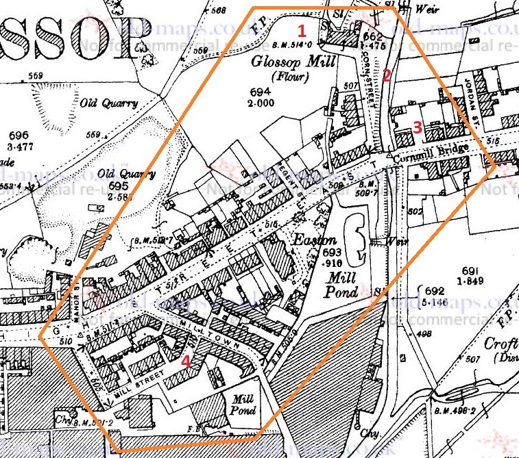
Despite its location, and seemingly obvious derivation, Milltown as an area has nothing to do with the Victorian mills, but instead it is so named because of its proximity to the medieval corn mill. Situated on what is now Corn Street, the mill was owned by the Lord of the Manor, and the people of the area paid to have their corn ground there – and nowhere else. It was, to all intents and purposes, a bit of a racket, but one that was universal throughout the land at the time. As you can see from the map below (and from photographs), there was a flour mill here in 1898, an 18th century building replacing an earlier one. It was demolished in the 1920’s, but you can still see the mill leat running alongside Corn Street. Also, the bridge over Shelf Brook as called Cornmill Bridge, which I did not know until just before I wrote these words… I love that!
Milltown marked in orange, to include the Corn Mill. In reality, Milltown is now just the area to the south of High Street East. On the map above, you can see the Corn Mill (1), Corn Street (2), and Cornmill Bridge (3). Milltown as a present day place is that to the south of High Street East, and comprising Milltown (the street) and Mill Street (4). The area has changed massively, but one constant is the Prince of Wales pub on the corner of those streets (I blogged about it here); pubs are often the only thing left after whole streets are demolished, as indeed is the case here.
LEAN TOWN
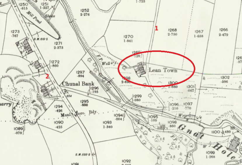
Lean Town is the name given to a group of four houses at the bottom of an apparently unnamed lane that runs from Hague Road to Gnat Hole. I can’t believe it is unnamed, but there you go… no map or document has so far given me a name! As you come from The Beehive toward Derbyshire Level, you pass a right hand downward track – follow this and eventually you hit Lean town. I wrote about Lean Town, here.
Lean Town. 1 is the track down from Derbyshire Level, 2 is Chunal.
The origin of the name ‘Lean Town’ is unclear; it might mean lean, as in not very rich, or poor for growing crops, or might be derived from ‘ling’, meaning the plant ‘heather‘ that grows around here.
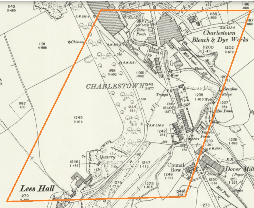
CHARLESTOWN
Once an area in its own right, it is now largely remembered in the name of Charlestown Road (and Charlestown Motors who I can heartily recommend, as it happens). It was named after Charles Hadfield who lived in Lees Hall in the late 18th century, and built the mill in Charlestown (now flats and houses).
Sort of this area, give or take. Charlestown Road runs from top down, and the PH (Public House) marked on the map is now Steak Land (replacing a firm favourite of mine, Casa d’Italia, although the word on the street is the Steak Land is amazing, so there’s that!)
ROUGHTOWN
Hope Street in Old Glossop was known as Roughtown, seemingly referring to the uncouth behaviour of its inhabitants, largely quarrymen from the nearby Glossop Low Quarries just up the road.
1 – Hope Street, 2 – The Greyhound pub, a factor in Roughtown’s reputation.
Apparently Roughtown was used as a semi-official name, with it appearing on census returns and trade directories of the time. Sticking with Old Glossop, we have…
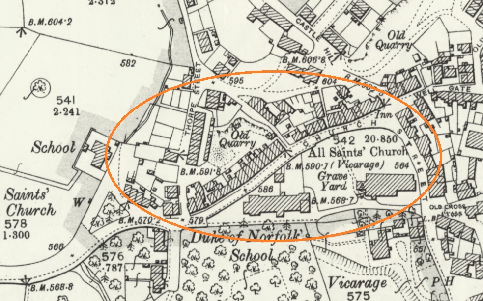
TOP O’ TH’ TOWN
The area between Thorp Street and Church Street in Old Glossop. It is, I suppose, quite literally the top of the town.
And the area at the end of Top o’ th’ Town is known as ‘Town End‘, which make sense. Over in Whitfield, however, we have…
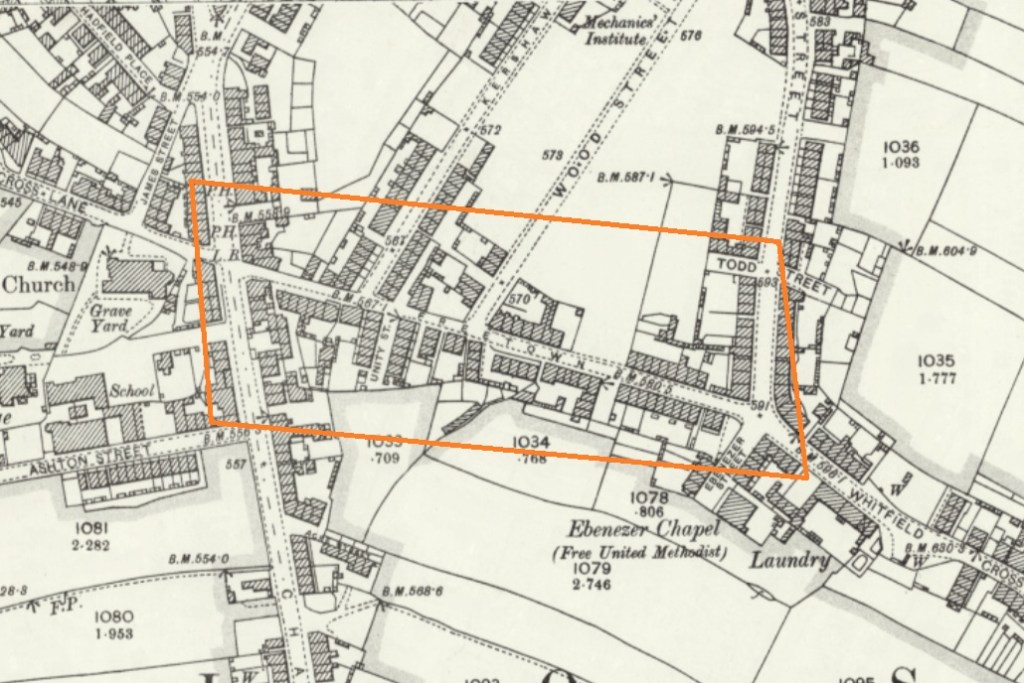
FREETOWN
Stretches from the bottom of Whitfield Cross to the junction with Charlestown Road.
This sort of area, here. and particularly the road called Freetown.
Technically, and originally, Freetown was the name given to this area of Whitfield, with the name being derived from the fact that the land in this area, and subsequent houses built here, were freehold, as indeed it is still the case (my own house here included).
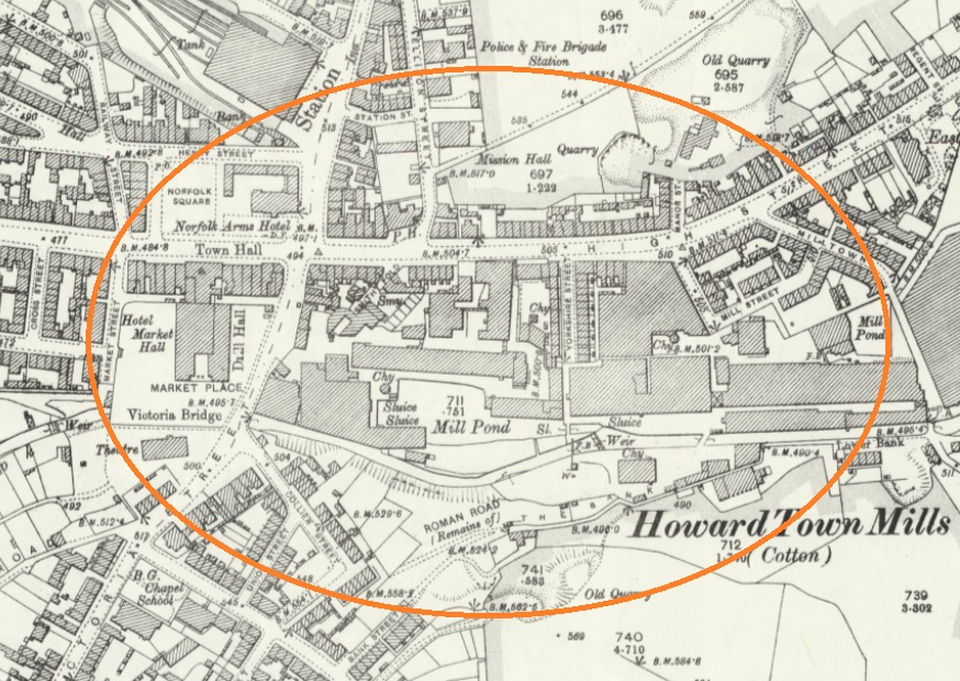
HOWARD TOWN
Essentially, what we understand as Glossop – the railway, Norfolk Square, the crossroads, and the whole area around the market and Wetherspoons.
Named after Bernard Edward Howard, 12th Duke of Norfolk (1765-1842) who invested heavily in Glossop – money and time. He built roads, the town hall, remodelled the whole area, and changed the focus of Glossop from what we now know as Old Glossop to what we now know as Glossop, but was originally Howard Town. This may have been the start of the ‘town’ naming process, as others followed suit, whether by flattery or through satire.
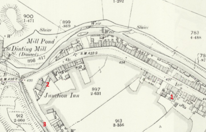
JERRYTOWN
A bit of an obscure one this – it’s mentioned by Hamnett as stretching along High Street West, from roughly The Grapes inn to the former Junction Inn and around.
1 – The Grapes, 2 – The former Junction Inn (now Simple Lettings), 3 – Primrose Lane.
Apparently named after a Jerry Sykes (1779 – 1856) who built a number of houses in this area in the 1820’s.
And there we have it! The many towns of Glossop town. I can already feel several of you desperate to tell me that I’ve got something wrong, or that I’ve missed a ‘town’ out. Please feel free to do so. Honestly, please let me know if I’ve messed up – I’d rather the information was correct.
I do have pottery for next time, and I owe you a new Rough Guide To Pottery – Part 11 unless I’m mistaken, you lucky people, you.
In other news, I’m doing a guided walk at the end of the month… which should be amazing.
Now that spring is coming I’m going to be walking the route of the Where/Whens so far published, and trying out some other new routes. Tickets for these will be available after the above walk has been done, and will be at the weekend, so everyone can take part – come and join us! Watch this space.
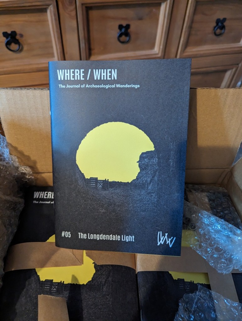
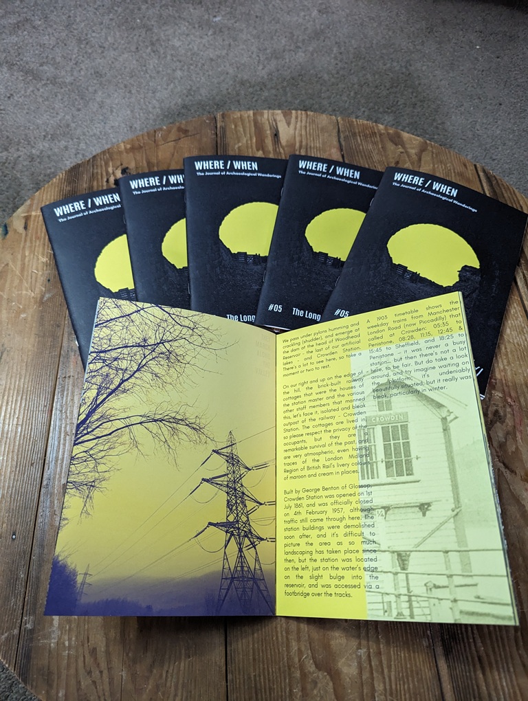
Talking of Where/When, No.5 has just been released.
An exploration of the history and archaeology of the Longdendale Trail, from the start at Hadfield to the tunnel entrances. Honestly, there is so much to see.
It’s available to buy from the usual places – Dark Peak Books, 96 High Street West, Glossop; the website’s store; or you can track me down and buy one.
I’m busy! Too busy, but it’s happening! I’ll post again soon, but until then, please look after yourselves, and each other, and I remain.
What ho, you wonderful and slightly strange bunch, you.
A quick one today… I have had almost no spare time to do much more. I have just finished the new edition of Where/When (No.4, The Melandra Meander) – which has taken all my time – and I’ve just started a new job! Busy busy busy! But the Cabinet of Curiosities is a priority, and you, kind and gentle readers, are very important. Plus, if I don’t publish something on the website, angry crowds start to gather outside my house, chanting and making threats – I mean to say, one has to think of the neighbours.
So here we are – a second part to the Datestone post I wrote 3 years ago (three years? Where has the time gone?). I’ll spare the introduction as the original covers that, and just dive in to say that all of the datestones are pre-Victorian (before 1837) – I’d like to do a survey of the datestones of the Victorian and later periods, but there are so many that it would be a big task. If anyone fancies giving me a hand, though, give me a shout.
So then, first up is a correction. Hurstnook Farm has a stone that I drew through a pair of binoculars, as I couldn’t get close enough to photograph it. Well, they’ve been doing some work there recently, and me being me, I wandered over and asked if I could take a snap, and Lo! The result is below.
F.S.M.W, and the date of 1772. Lovely detailing, too – this is an expensive looking stone.
And a wonderful datestone it is, too. Different from my interpretation of it, and I still have no idea of the names; W is probably the family name – possibly a Wagstaff? I’m sure looking through some deeds would produce a name, though. Any thoughts, anyone? There is another datestone on the extension next door that reads 2010, but is designed to copy the original one, to fit in with the building.
Next up is #13 Padfield Main Road, Hadfield.
J.H.A 1826. Simple and effective.
A simple datestone, but I honestly love this one. And the colouring is effective.
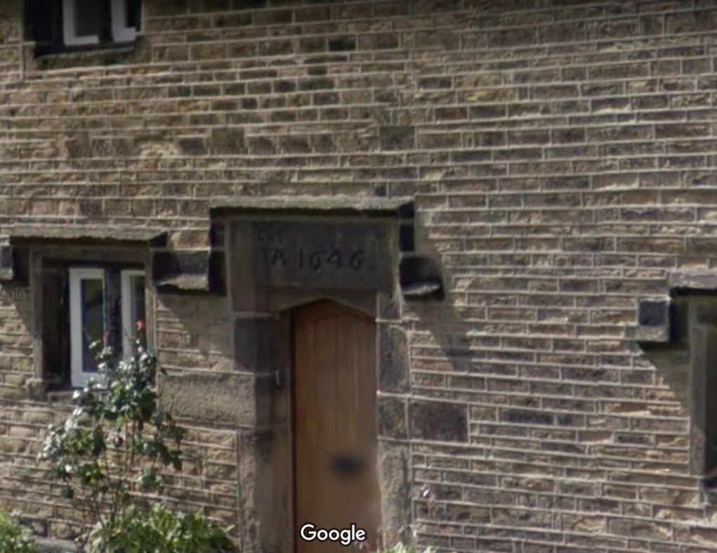
Next up, Hadfield Hall – a truly wonderful building. I could study this place for hours, and often find myself marvelling at the structure, and all the phases of construction. Now is not the time for a detailed look at the hall – a future post, perhaps. Still, it has a cracking datestone above the door.
I(J).H. T.A. 1646
Lovely stuff. Hadfield family? I’d love to know more – any thoughts?
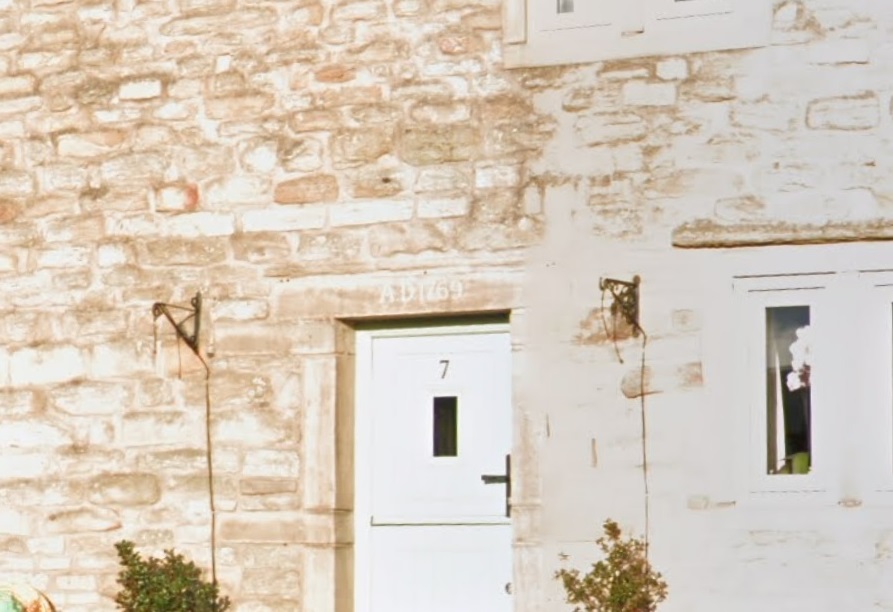
Just opposite Hadfield Hall is 7 Old Hall Square:
AD 1769
A simple date, rather than a chance at immortality.
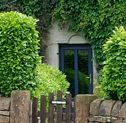
Next we have 2 from Shaw, the farmstead that is first mentioned in 1285. It forms one of a number of such places dotted around Mouselow, and is a fascinating place. I suspect there is a lot of history here, and would love to have a poke around some of the properties there. If anyone reading this in Shaw fancies letting a slightly odd bloke have a rummage, so to speak, shout out!
First is Shaw Farm Barn
G.B. (D) M.B. (B), 1694
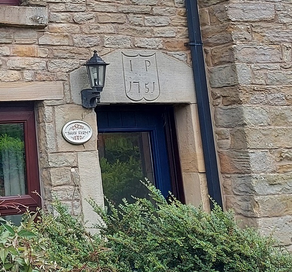
Not a great photo, but the inscription is correct. It’s on a whacking great lintel, which is very suggestive of an earlier, perhaps Tudor, door lintel that’s been re-used. Makes you think… And then, next door, is Shaw Farm:
I (or more properly J).P. 1751, in a rather fetching shield motif.
The names here again escape me – J.P. (the ‘J’ is rendered as an ‘I’ as was the custom).
Next up, the Hare and Hounds, Simmondley.
G.B.P. 1784
I actually know the meaning of those initials – George and Peggy Booth. Also in Simmondley, we have Dingle Cottage which sits on the old trackway from the farms over Whitley Nab way.
M.L.R. 1706
A truly fascinating building, and again, one in which I wish I could have a poke around!
Next is Hall Fold Farm, Old Glossop.
J.S.J.G. 1806
The datestone was apparently found buried whilst the farmhouse was being renovated. The image is not mine, but was taken from the always interesting (and essential if you like Glossop’s history) Old Glossop History Trail website. I want to take one of my own, but oddly people view Herberts taking photographs of their houses with a bit of suspicion!
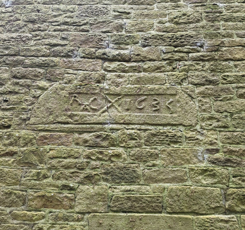
Another Old Glossop datestone is unusual – this is built into the side of Hillside Cottage, down by Laneside Farm:
R.A.C. 1635, with a decorative saltire.
A few things to say about this one. Firstly, it is the second oldest datestone in the Glossop area, pushing Hob Hill Cottage in Whitfield into third place. Secondly, the decorative saltire might also function as a protective motif, as the shape is a fairly commonly found apotropaic mark. But the important thing is that it is not in its original position, above a doorway, and in fact the house it is built into is late Georgian or early Victorian. I can only assume that it replaced an earlier building, and rather than throw the lintel away, the builders thought they might as well build it into the fabric of the house as decoration. As for the initials – I have no idea.
Next up, and finally: Flax Cottage, Wesley Street, Old Glossop.
S.W.E. 1783, and a little flower motif.
The flower motif in Flax Cottage is very similar to that at Hurstnook Farm – possibly the same stonemason carved it 11 years later?
Ok, so that’s it for datestones. There are others in the area – a few in Charlesworth, Herod Farm, Hobroyd Farm, etc. – but I don’t have photographs yet. If anyone does, or if anyone knows of any others that I don’t know about, then please give me a shout.
In other news. As I say, Where/When No.4 is about to be printed – I sent it yesterday, so it will be here next week, fingers crossed. I’m super excited about this one, and it might be the best yet. I’ll post more soon, and with other news too. But until then, look after yourselves, and each other, and I remain.
What ho, you wonderful people, you! Well, here we all are. Make yourselves at home. Canape? Glass of something cheering? I can heartily recommend the red… cheeky, but hexagonal in the correct places, if you know what I mean. Right, take a seat and I’ll begin.
Today’s offering concerns a subject very dear to my heart. No, not pottery… I’m not completely one dimensional, you know. Nope, this article concerns pubs. And alcohol. And in particular the effects derived from the consumption of the latter. “What’s this?” I hear you cry… “a post about drunkenness? By a man with the sober reputation of good old TCG?” Hmmm… let’s move on.
So, I was reading through the diary of George Booth (discussed further here) the other day, and came across this absolute gem:
Thursday July 25th (1833) Last sunday afternoon [21st July] I went with Harriet Hough, our Mary, James & George Booth to Glossop Church. After service we went to Joshua Shepley’s at the Royal Oak and then returned by way of Bridge End Juncksion, Simondly and we did not forget to call at each place and to my own shame I was quite drunk. fell and broke Miss Hough`s Umbrella and tore my Trowsers.
I say!
So, what are we to make of that startling confession? We could judge Mr Booth harshly, but let’s face it, we’ve all been there (though I don’t recall ever having broken someone’s umbrella). Two things leap out of this entry. Firstly, there are the post-church snifters – seemingly many of them – in what was, for all intents and purposes, a pub crawl of Glossop that starts in the Royal Oak and ends at Bridge End (appropriately enough, where Wetherspoons is now). The amusement here is, I think, the result of a sincere and honest Georgian/Victorian gentleman, getting sozzled after church, staggering home, breaking an umbrella, and ripping his trousers. Quite how this happened I’d love to know (the ripping, not the drunkenness… I’m very aware of how that happens!), but the diary entry is somewhat lacking in details.
Secondly, there is the comment that they returned via “Bridge End Juncksion [junction]”, implying the meeting of a number of roads. My sherdy-sense tingled, and the question was asked: “is there a blog post here?” Well… here we are!
Ok then, let’s examine the route our man and his party took, firstly from the church to the Royal Oak. There are two ways he could have walked. Firstly, down Manor Park Road (then called Hall Street) and left down what was then Cowbrook Lane, but is now the A57/Sheffield Road, and along to the Royal Oak. This would have had a decent road surface on it now – the turnpike road – the Snake Pass – had been open for some 12 years at this point. But this would mean they would have to double back on themselves to get home. No, I think it would make sense to take the more direct, and almost certainly original, route, along the track from Hall Fold (passing the Glacial Erratic) and via Pyegrove, finally popping out at the pub on the road there. This was an established track, rather than the simple footpath it is now, and for many hundreds of years was used by man and beast to get from (Old) Glossop to Hurst, Jumble, and ultimately Whitfield – a not insignificant trackway to be honest. There was also a spur from this track to Mossy Lea farm, and joining Doctor’s Gate.
All Saint’s Church, Glossop circled in green at the top. The Royal Oak is circled in blue at the bottom. Hall Street (now Manor Park Road) is in orange, The Pyegrove track is in red, and continues beyond the Royal Oak to Hurst, etc. In pink, we see the spur – Woodcock Road – that goes to Mossy Lea and Doctor’s Gate.
The Royal Oak was constructed in or just before 1818 as a purpose built alehouse by the Joshua Shepley mentioned in the diary. It sits on the then new Snake Pass, and had stables and a blacksmith, as well as water trough. Shepley clearly knew he had a captive market – the first watering hole you come to after the Snake Pass, and the last as you leave Glossop for the road, meaning a last chance to water or shoe a horse, as well as a pint, too. As a building, it’s a wonderful example of the neo-classical late Georgia/Early Victorian ‘symmetrical with a central doorway’ style that was very common amongst purpose built pubs of the time. Actually, it’s a little off perfect symmetry, as indeed they all are, presumably to accommodate a larger room and a smaller one – here the larger is on the right – but let’s call them symmetrical. The porch covering the front door is a later addition.
I love this view – it really shows the looming presence of Shire Hill in the background. And honestly, Shire Hill looms… I actually find it quite an intimidating place. Another view, the track from (Old) Glossop via Pyegrove comes out on the left The trough at the front… full! The last time I saw this, it was bone dry. I always find it odd, and perhaps a little mystifying how the water table fills up, and how quickly following a decent amount of rain.
I feel that if Booth purposefully went there to see the place, and the man, he would certainly had more than a single drink; at least two is my guess, although potentially more. We’ll say two to be on the safe side.
DRINKS CONSUMED: 2
So then, from here they would have wandered down Cowbrook Lane, and come across what would become the Commercial Inn on the corner there. But whilst the building – or an earlier incarnation – was standing there (a lease for the building was granted in 1828), it didn’t have an alehouse license at this point (that only came about in 1839). However, it might have had a simpler beerhouse license, as almost anyone could obtain a license to sell beer brewed on the premises if they paid a 2 guinea fee. One can imagine the sort of clientele this sort of establishment could attract – cheap and cheerful beer a plenty. I’m not 100% convinced our man Booth would have frequented a beer house, but I could be wrong – especially if he’s on the razz! So, benefit of the doubt, he bent his elbow at the Commercial, or what was there at the time.
The Sheffield Road side of The Commercial Inn, blocked up doorway visible front and centre. This is the door that George Booth and party would have entered on that fateful evening. Close-up of the doorway. A dark and rainy view of the Manor Park Road side of the pub, now the only way to get into the building. Again, the symmetry is obvious.I’m not certain, but these two houses share all the same features – windows and doors, and symmetrical shape – as the pub they are joined to… they have to have been built at the same time, or at least soon after (actually, the stone size and shape is slightly different – look left where the join in the roof is. I wish I’d taken a closer photo now. But I’d still bet money that they were built by the same person, and within a year or two.
The current building is also of the ‘symmetrical’ style, although this example has the central doorway on both the turnpike road and on Manor Park Road (then Hall Street), which make good commercial sense, although the Sheffield Road doorway has been bricked up. I’ve said it before: objects (in this case a building) acquire a biography, and throughout their ‘lives’, like ours, they constantly change, and often carry the scars of their history. A bricked up doorway prompts so many questions, some of which are easily answered, others not so much. Was this an entrance to a separate room? The Smoking Room? Taproom? Lounge? Vault? Or was it an entrance to the private quarters?
DRINKS CONSUMED: 3
Onwards and upwards. From here, the next establishment he might have come across is the Mechanic’s Arms at 99 High Street East. Built in 1831 by Jordan Hampson, who is listed as a beer seller in the 1841 census, and who would have been the landlord in 1833. The building ceased to be a pub in 1933 because of its “structural unsuitability”, and the building was demolished in 1971. Regency Court now stands in its place.
Not a lot to say here! Somewhere in the middle of this photo stood the Mechanic’s Arms.
So we might assume an eyeball straightener here, then.
DRINKS CONSUMED: 4
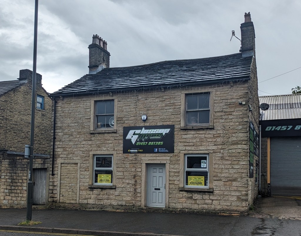
Next up and a little further down we have The Peartree Inn. Built in 1818, it was originally known as the Kings Arms.
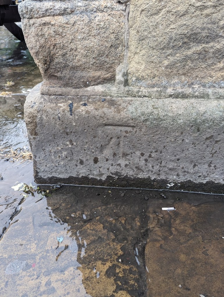
Once you notice it, you can clearly see it was once a pub – symmetrical windows with a central door. Although, there is another bricked up door on the left, again perhaps the entrance to a separate room.The bricked up doorway up close. What was originally – I presume – the main entrance to the pub, and through George Booth and his party would have passed.And, o’ happy day, a bench mark! For those of you who don’t know, these were carved onto buildings to mark a specific measure height above sea level in the 1840’s and onwards. I love these things – the horizontal line marks the exact point, and the arrow below shows you where. This is exactly 504ft 7″ above sea level. Man, I love a bench mark! Check out this blog article, and many more like it in the archive.
It was here that in 1830 that the officers of a detachment of the 10th Hussars and 4th Regiment of Foot were stationed, being given the task of putting down a potential riot of spinners who were demonstrating in favour of a standard rate of pay. In 1832 it would have been owned by a John Woolley, himself an old soldier. We might safely assume they took one drink in the Peartree, although the chance of a chat with an old soldier… let’s say 2. It is a Grade ii listed building, with the official listing thus:
House, now offices and attached wall. Early C19 with late C19 and C20 additions. Coursed millstone grit with tooled dressings and stone slate roof. 2 stone end stacks. EXTERIOR: 2 storey and attic. Street front rendered. Almost symmetrical 2 window range. Off-centre doorway with C20 door in flush ashlar surround flanked by single plain sashes, above 2 plain sashes, all in flush ashlar surrounds. Left return has blocked tall opening at first floor level and above single plain sash. Right return has ground floor with elongated C20 window opening. Rear has C19 parallel extension with end stack. INTERIOR: not inspected. SUBSIDIARY FEATURES: adjoining wall to left has doorway in flush ashlar surround with plank door.
The Peartree ceased being a pub in 1926, and is now the offices of Glossop Tyres – make sure you check out the building the next time you are getting new tyres.
DRINKS CONSUMED: 6
Swaying slightly (we’ve all been there) they would have set off – it’s thirsty work, all this walking… Next up, the Howard Arms, for at least one.
Howard Arms, Ellison Street in the foreground. Again, like the Peartree, it was originally symmetrical, with the door central between the two ground floor windows. It was bricked up when the pub expanded into the building next door sometime after the 1930’s. That is the one George Booth and party would have used. A view of the Howard Arms in 1904, central door still in situ. The person in the doorway is likely to be the wife of John Green Hudson, landlord at that time. Image from the always excellent Glossop Victorian Architectural History site – HERE. Well worth a browse as it is full of old images, and catalogues our extensive and important Victorian heritage…. it really is an important website.As it is now, and after the windows were widened – still 3 light, only wider.
Named after the Howard family, the Dukes of Norfolk, it was built in 1800. It is superbly situated for passing trade, being at the crossroads of the old Woodhead Road (now Ellison Street) and the turnpike road running east-west, later expanded into the Snake Pass. Indeed, the trustees of this road building committee held their first planning meeting here, on 4 June 1818, and celebrated its opening four years later with a slap-up meal in the pub. A very nice establishment (possibly), I feel certain that more than one was consumed here. For one, he was already 6 drinks into this adventure, and at this point, the genie is hard to push back into the bottle, and trouser-ripping and umbrella-breaking are all but inevitable. But I also get the impression that he is having a good time, despite the shame he felt the next day, and the diary makes it very clear “we did not forget to call at each place“.
DRINKS CONSUMED: 8
From here, the party would have headed further down, and into the Norfolk Arms. Built in 1823, there is quite a bit that can be said about the pub, but I feel here is not the place – this is Mr Booth’s time to shine – so I’ll keep it brief. Built in 1823 as part of the monumental shakeup of this area, and the creation of Howard Town, The Norfolk Arms has been much altered and expanded over the years, especially in the late 19th century, but at its core it is another example of that neo-classical ‘symmetrical with a central door’ that define so many purpose built pubs of the late Georgian/Early Victorian period (the front porch is a later addition).
Apologies – this shot is taken from Google Maps’ Streetview. I took several photos of the building, from several different angles… but for some reason, none of them came out ok. Odd, but there you go. I’ll update the photos later, but for now I just want to get the article out there! You can see the central, ‘symmetrical’ building, with the later wings added. Oddly, this is the only photograph that worked properly! The bench mark on the south-eastern corner of the building marking 497ft, 1″ above sea level.
It is also slightly grander than many of the other examples – larger and more formal, it was also used as the town’s post office in the 19th century, as well as the coaching inn, where stage coaches between Sheffield and Manchester would stop. The Norfolk Arms is a Grade ii listed building, with the official listing reading thus:
Coaching Inn, now public house. 1823, altered late C19 and C20. Coursed millstone grit with ashlar dressings and hipped Welsh slate roofs. 4 ridge stacks and 3 wall stone stacks plus 2 louvred vents to left. PLAN: double-depth. EXTERIOR: 2 storey. High Street front has 7 windows arranged 2:3:2. Slightly projecting 3 window centre has central stone, flat roofed single storey porch with blocking course, plain square columns and C20 margin light glazing. Flanked by single plain horned sashes, above 3 similar windows. Wings have 2 similar sashes to each floor. All windows have painted ashlar lintels and sills. Left return has doorway in flush ashlar surround with overlight and to left single small then 2 large casement windows, above 3 plain horned sashes. Right return to Norfolk Street has central doorway under single storey flat roof porch with dentilled cornice supported on square Tuscan Doric columns, moulded round arches with moulded imposts and stressed keystones. To left single plain horned sash and to right large former shop window with former doorway to left and 3 round headed lights to right within plain pilaster surround with moulded fascia board. Above 3 plain horned sashes and small inserted casement window.
And it’s difficult to argue with that! The landlord in 1833 was a Joseph Oates, and I think they had single drink in here, as they decide to call it a night and head home.
DRINKS CONSUMED: 9
The diary states that they went via “Bridge End“, which means they would have crossed what was then a new bridge, but not yet Victoria Bridge. This whole area was in flux at that time, with new road layouts and buildings going up, and it may well have resembled a building site. However, there was one shining beacon on this dark and lonely road out of Glossop, one place of refuge and light. And beer; The Albion Hotel (also known as The Trap, The Last Orders, and now The Brook Tavern), which in 1833 was brand new, being built the previous year. Maybe just one more…
The Brook Tavern as it is now, originally The Albion. The porch is a later addition, but would have originally been like our other pubs so far, symmetrical with a central door.
Set back from the modern road now because it sat on the original line of the road and bridge (and lines up with Smithy Fold and Ellison Street), it would have been a magnet for the party – to celebrate crossing the bridge, and one for the road. The last. No more… “Ah, go on then, let’s have another…” The landlord at the time would have been a Charles Calvert, who by this point would probably have been glad to see them go!
The original line of the road can be seen by looking along the shop fronts here – they pinpoint the site of the original bridge, and Ellison Street beyond. The new road curves more to the west, over Victoria Bridge.
TOTALDRINKS CONSUMED: 11
And so, singing hymns – and other, less saintly songs – our party staggers into the night, and into infamy. Blimey… 11 drinks! Not bad for a Sunday session, and certainly more than I could do anymore. The ‘pub crawl’ is a brilliant piece of social history, a glimpse into the personal life of a person whose public life was probably very different, possibly very austere and proper – so the idea of him getting squiffy on a Sunday is amazing if, as he notes, shameful, as the sobering up starts, and he fits back into his public persona.
Now, here is also something of a question mark. His diary records that they went via “Bridge End Juncksion, Simondly“, but that is an odd way of putting it. Bridge End is Victoria Bridge, but it is not in Simmondley. Whitfield or Glossop, depending on which side you are standing (I get the feeling Bridge End proper is on the Glossop side of the brook), certainly, but not Simmondley – that’s over the water of Long Clough Brook. There is Bridge Field, which is just in Simmondley, but it is much further away. No, I suspect he may simply be confused: a bridge over water from Glossop… that’s Simmondley. Plus, he’s a Chisworth/Charlesworth man out of his territory, he may not have understood the finer points of local geography. And let’s not forget he was also somewhat impaired, mentally, by the time he arrived there!
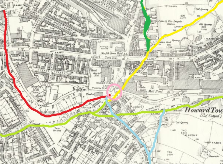
So then, the ‘Juncksion’? A junction, or a meeting of roads. But from where? This is where Glossop’s history gets murky… and interesting. It is a dispersed settlement, with farmsteads all over, all of which feed into the centre – Old Glossop. Because of this, trackways spread spiderweb-like all over, connecting all of these places and people. A crossing point like Victoria Bridge – or rather the bridges that were there before – were naturally targets, focal points attracting all the tracks, as ways to cross Glossop Brook, would not have been common. Here on the map is shown the tracks. It should be stated that not all would have been in use simultaneously, they would have been introduced as needed; a new farmhouse built, perhaps means new tracks are made – but all heading for the single focus of the crossing point, the bridge.
The tracks that meet at Victoria Bridge. Pink: Victoria Bridge, Red: from Ashes, Green: from Simmondley (the main Simmondley to Glossop track, and which becomes Bank Street [The Bonk], Blue: from Whitfield, Yellow: the track to (Old) Glossop, Dark Green: the track to The Heath, and on to Padfield, but also Woodhead, and ultimately Yorkshire. A Juncksion indeed.
This article owes a huge debt to the book History in a Pint pot by David Field – a brilliantly detailed look at all of Glossop’s pubs, past and present, now sadly out of print and ridiculously difficult to get hold of. The library has a copy, so go there and read it. I’d also like to thank George Booth, especially as this is the second article inspired by his diary. I also feel slightly bad about lampooning him, however good natured it might be; after all, the shame he felt at being drunk was real enough to write about it in his personal diary. By way of an apology, I might raise a glass of the stuff that cheers his way tonight… although I’m not sure he’d approve.
However, I’m genuinely half tempted to recreate this monumental pub crawl – starting at the Royal Oak, and finishing in the Brook Tavern… and celebrate the end by tearing a pair of trousers and breaking an umbrella? Who’s with me? 21st of July this year is, coincidentally, a Sunday, but I feel that we live in less civilised times, and those of us who work will not appreciate waking up Monday morning. We could do it the day before – Saturday 20th. Just a thought… let me know what you think.
In other news, Where / When issue 2 is selling like hot cakes, which is great as it means that I can publish Where / When 3 relatively quickly. I also have some archaeological/historical walks planned for the summer – essentially me doing a Where / When live, with a bunch of you, if you fancy. And perhaps incorporating the inaugural George Booth Historical Stagger? But honestly, watch this space as lots is being planned…
Until the next time then, good people of Glossop – and beyond – please look after yourselves and each other.