What Ho! And a happy New Whatsit to you all, yes, even you Mr Shouty-Outy, even you.
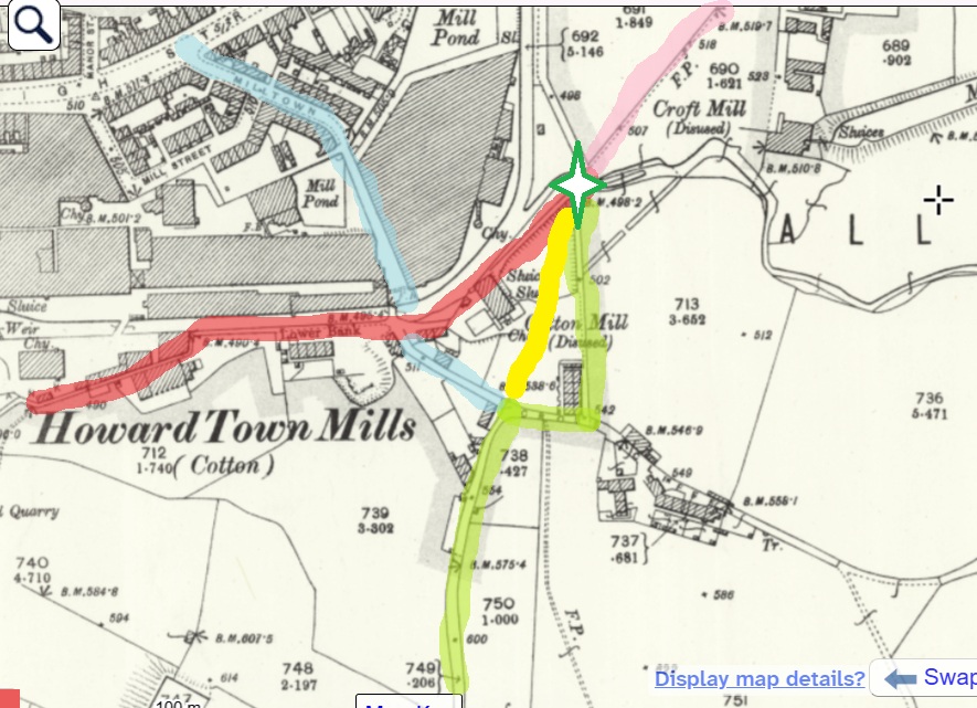
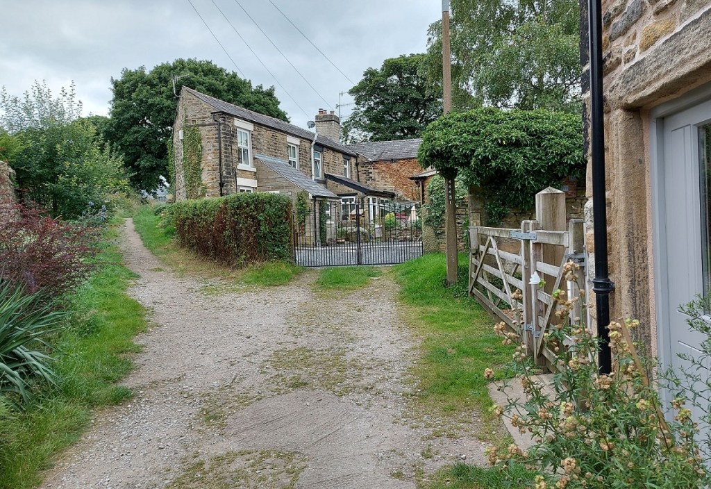
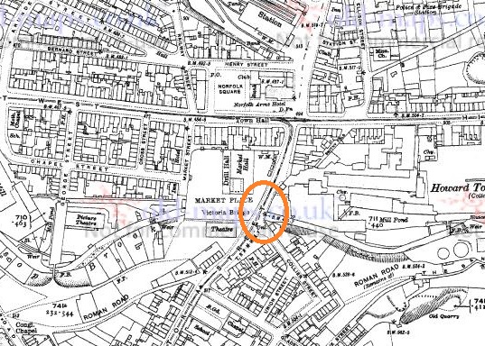
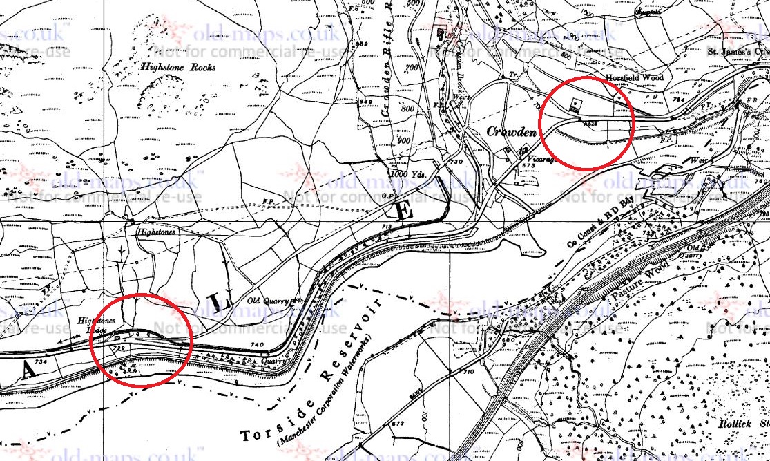
So, I was wondering down Cliffe Road in Whitfield the other day – actually on my way to Lidl, since you ask, and yes, to buy a bottle or two of the stuff that cheers… amongst other things (mainly cheese, if I’m honest). The road dives steeply down, and then takes a left turn at the bottom, and leads past the new build houses on the old Velocrepe site and onto Milltown. Now, I’ve always found this stretch of road very interesting. The main road from Chapel en le Frith to Glossop (and beyond), and thus Anglo-Saxon in date, it originally seems to have carried on straight, where it joined The Bank – the medieval/Post-Medieval track coming from Simmondley to Glossop – and together crossed Shelf Brook via the foot and road bridge at the entrance to Shirebrook, but was presumably then a ford or basic bridge. The route of this track was altered when a mill was built here, probably in the 1780’s (dates are a little fuzzy), and a mill pond put where it once ran. The newer route was/is to the right, and then down, past some mid 19th century houses there. Here, this carefully and skilfully annotated map explains it better visually than I can with words:
Green – Cliffe Road, with the right hand kink, and then straight ahead. Blue – the left hand late 18th/early 19th century extension to Milltown. Red – The Bank, the road from Simmondley to Glossop. Yellow – the original route of Cliffe Road, moved when the mill and millpond were put there. Green Star – the location of the crossing over Hurst Brook (a ford or bridge). Pink – the route from the bridge to Glossop.
But here I am again, getting distracted! This post is not about the tracks… well not as such. But rather, what such tracks were made from. The earliest tracks were simply mud, and were impassable in the rain, or with winter blowing cold, and Glossop was notorious for its frankly crap roads, which would have been patched and ‘surfaced’ with rough stones as and when it was needed, the remains of which can be seen occasionally be encountered peeking through the tracks where it has been worn.
I’m not going to go into the history of the roads in the Glossop area, as it has been covered in detail elsewhere (Glossop Heritage Trust), but in summary. it is only with the advent of the Turnpike Roads in the late 18th and earlier 19th century that Glossop finally got some ‘real’ roads. These high quality, well built and maintained, turnpike roads were paid for by a private consortium which recouped the money by charging a toll to travel on them. The introduction of these toll roads changed Glossop permanently, as it meant that the vast economic potential of Glossop’s mills could be fully realised; prior to this, mills were restricted, as it was difficult to get your finished cloth out, as well as raw materials in. Once this was problem was solved, the full brunt of the Industrial Revolution could be unleashed, bringing with it all the positives, and negatives, of this turbulent time (and if you know me, the you’ll know I’m essentially a hobbit, and so I think it was all a huge mistake!).
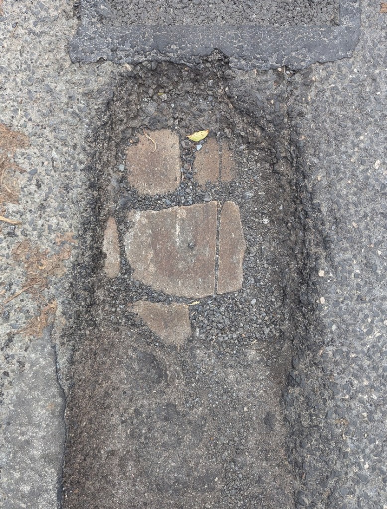
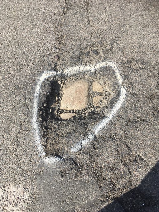
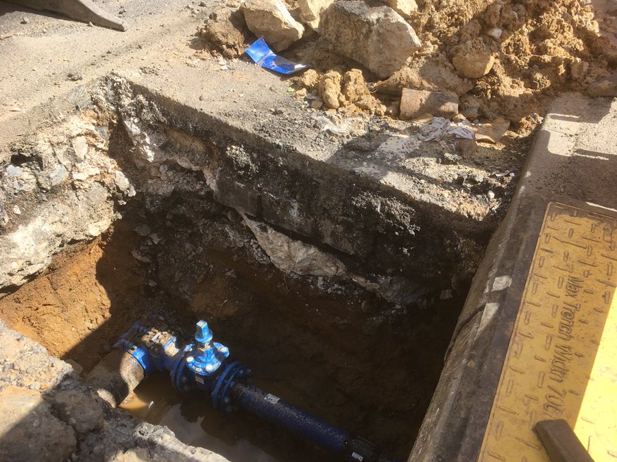
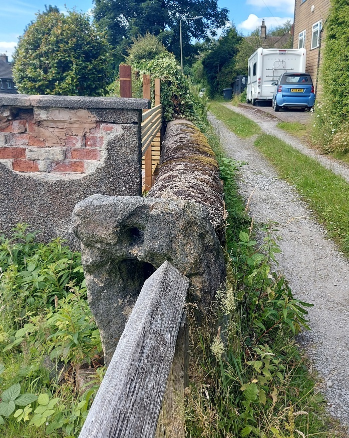
So, there I was, wandering down the bottom of Cliffe Road (in blue above), when magically, beneath my feet I saw this:
Peeking through, the past – always with us, sometimes at our feet.
The woeful state of the roads here in north Derbyshire, had revealed the original road surface; ‘What ho, setts!’ I thought.
So what are we looking at? This is the original surface of the road, dating to the time when this sideways step was constructed in the early 19th century (the datestone on the house at the bottom there reads ‘1815’, which is perfect). These are the setts that made up the road itself – a sett, which is deliberately shaped by human hands, rather than a cobble which is natural product and can be picked up off the beach. The fact that each one of these was shaped by hand frankly blows my mind! What a tedious, tiring, and unpleasant job that would have been, day in, day out. And how many 100’s of thousands… millions, would have been used in Glossop alone? Frightening stuff.
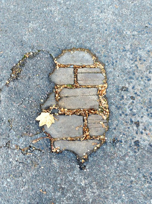
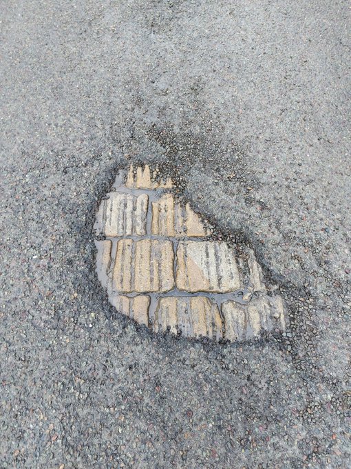
As you wander about Glossop, you can often encounter these sneaky little portals to the past, and I like to stand on them, imaging what stories they could tell. I also take photographs of them… what’s that? Hmmmm?… “I say, TCG old chap, you couldn’t show us some photographs could you?”. Well, I’m glad you asked, old bean, because I have few I could share!
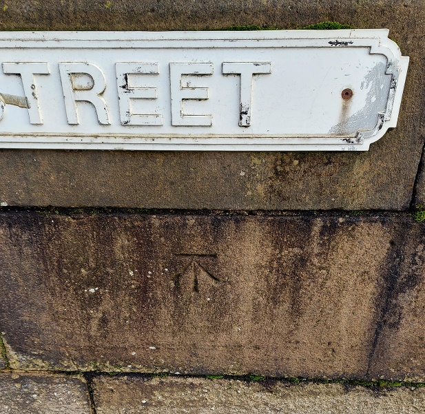
These were on Wood Street
Shaw Street
Gladstone Street
The reason that we can see this is that the modern tarmac can’t get a good grip on the smooth surface of the Setts, and it simply peels of over time. They tried to solve the problem by scoring deep lines into the stone, but that doesn’t seem to have worked, either!
The scoring must have been done mechanically.
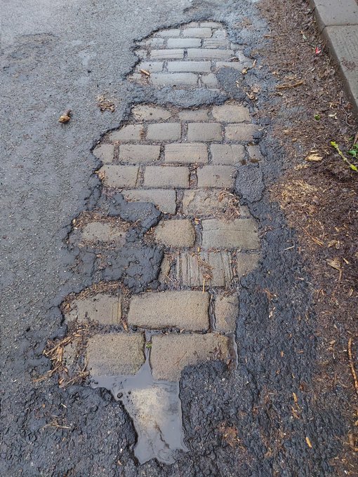
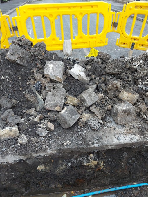
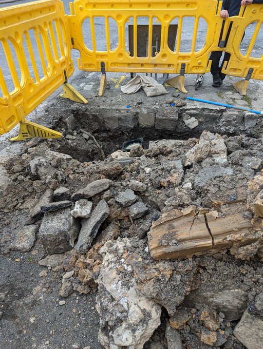
Occasionally, when there is a problem and the road need opening up, they have to pull up the setts, and you can can see how they were laid.
King Street
St Mary’s Road – you can see the setts just below the surface
Charlestown Road. Note the setts here are sitting on a bed of cinders and chalk.
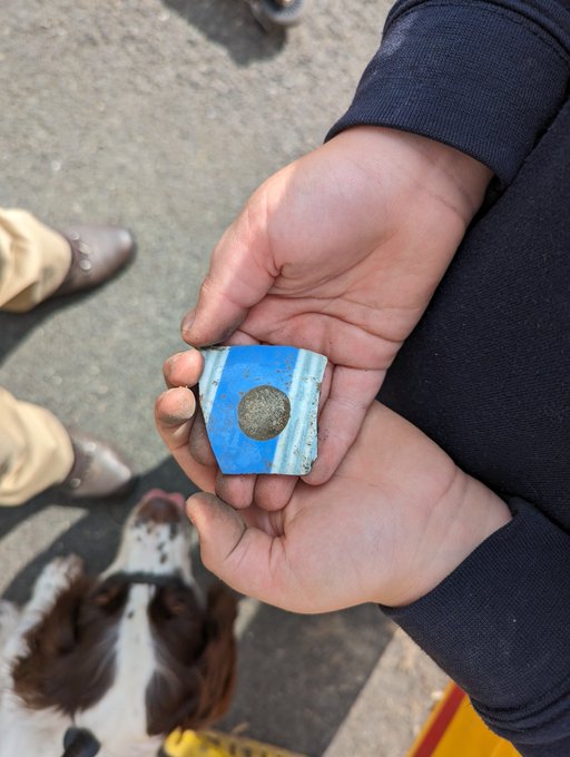
And, of course, you can sometimes get lucky with the spoil from these excavations, and find a piece of pottery… obviously you can’t have an article without pottery!
Lovely – banded ‘annular’ Industrial Slipware. In this case, it dates to not later than 1850’s.
Also, this provides us with a terminus ante quem, meaning that the pottery could only have been deposited before the road was laid down, which is the case of St Mary’s was mid 19th century, or slightly earlier. Wonderful stuff!
And of course, sometimes, the setts roll out of the spoil heap, and into… well, let’s not beat about the bush – my garden. It seems such a shame to just let them disappear into the truck and be driven off to a landfill somewhere, or to be used as hardcore for a new road. That saddens me greatly. So occasionally, they – magically – roll into the garden. Uphill. And sometimes over great distances. Following me home, if you will! And I can tell you this, they are heavier than they look!
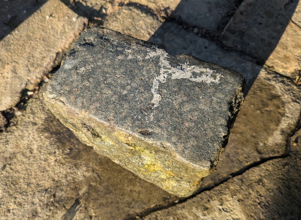
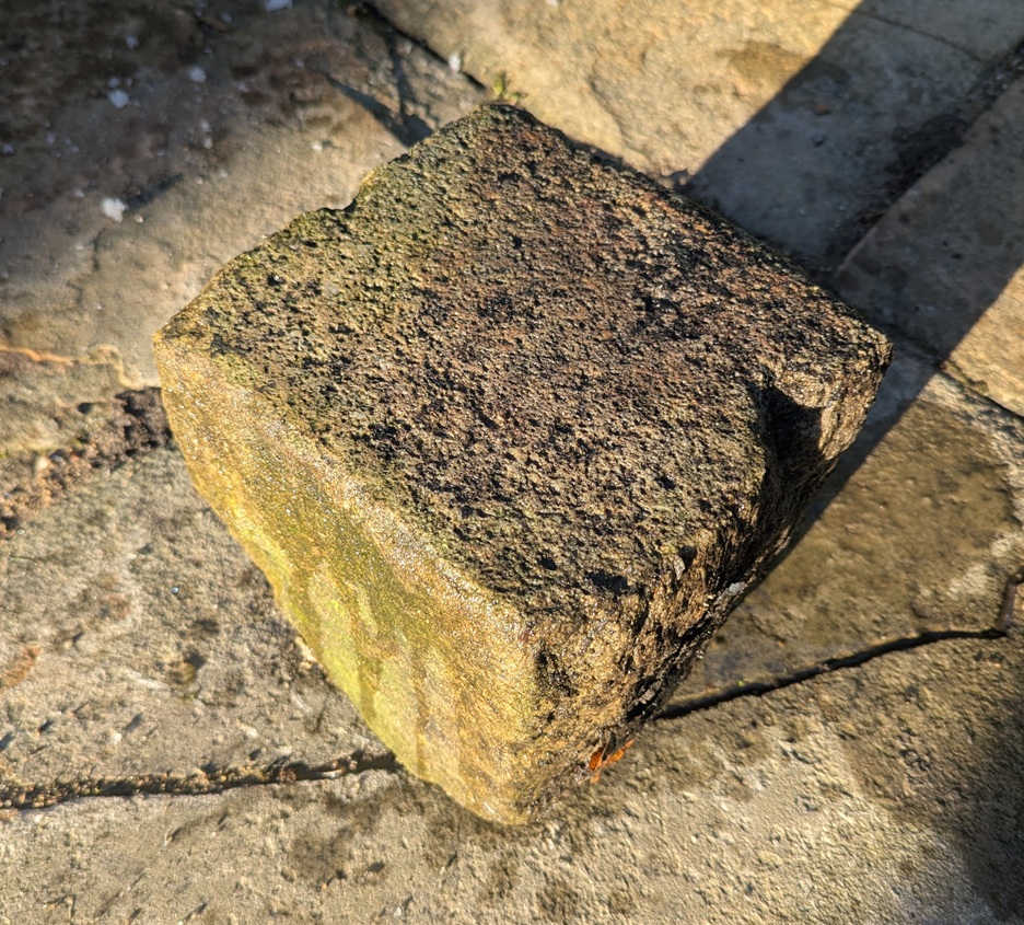
A King Street Sett, a lovely grey colour. I think it had paint spilled on it as some stage.
It measures 7″ x 4″ x 5″, and has a smooth even surface. Hamnett suggests that King Street was laid out in the 1840’s and 1850’s, which makes sense.
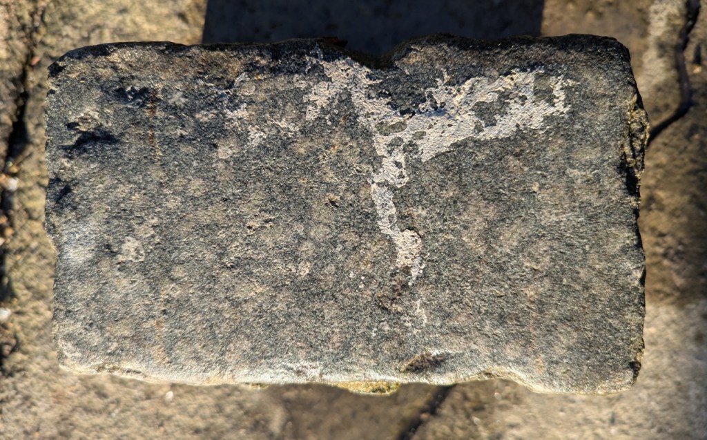
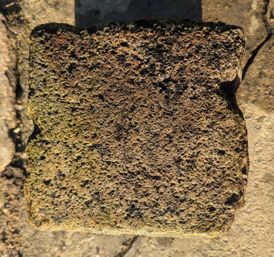
Turnlee RoadA more coarse surface.
Measuring 7.5″ x 7.5″ x 6.5″, the Turnlee Road sett is bigger, and has a rougher surface. This one is older, too, as it was presumably laid in the 1790’s when the turnpike road was put through, and is thus a real piece of Glossop’s history: who knows who and what travelled on this surface.
The King Street stone seems smoother, and thus more worn, than the Turnlee Road sett. This is odd – surely Turnlee would have seen much more traffic than King Street? But the differences may be explained by the location of the stone within the road surface; King Street was taken from the middle, whereas Turnlee was, I seem to remember, came from the edge of the road, where presumably no traffic would pass. It might also be explained by different stones being used – the Turnlee stone looks almost like a hard-wearing granite, whereas King Street seems more like a local gritstone. But I admit I am no geologist, so if anyone knows any better, please do shout out and correct me.
These are not the pretty bits of archaeology; the fancy buildings, the lovely pottery, the flint, the burial mounds, the Roman fort. Instead, this is simply the nuts and bolts of it – a road surface. And yet it has that vital link to the past, that important accessibility, that allows us a glimpse underneath the modern, and for that, I find them endlessly fascinating.
Right-ho! That’s all for now. My only New Year’s resolution this year is to publish more on the website, but to make the articles smaller, and thus quicker to write. I have another almost written, so I’ll go with that soon, and I’m working on all manner of other things, too.
Until then, though, look after yourselves, and each other, and please do get in contact with any thoughts or comments.
What ho, you wonderful and slightly strange bunch, you.
A quick one today… I have had almost no spare time to do much more. I have just finished the new edition of Where/When (No.4, The Melandra Meander) – which has taken all my time – and I’ve just started a new job! Busy busy busy! But the Cabinet of Curiosities is a priority, and you, kind and gentle readers, are very important. Plus, if I don’t publish something on the website, angry crowds start to gather outside my house, chanting and making threats – I mean to say, one has to think of the neighbours.
So here we are – a second part to the Datestone post I wrote 3 years ago (three years? Where has the time gone?). I’ll spare the introduction as the original covers that, and just dive in to say that all of the datestones are pre-Victorian (before 1837) – I’d like to do a survey of the datestones of the Victorian and later periods, but there are so many that it would be a big task. If anyone fancies giving me a hand, though, give me a shout.
So then, first up is a correction. Hurstnook Farm has a stone that I drew through a pair of binoculars, as I couldn’t get close enough to photograph it. Well, they’ve been doing some work there recently, and me being me, I wandered over and asked if I could take a snap, and Lo! The result is below.
F.S.M.W, and the date of 1772. Lovely detailing, too – this is an expensive looking stone.
And a wonderful datestone it is, too. Different from my interpretation of it, and I still have no idea of the names; W is probably the family name – possibly a Wagstaff? I’m sure looking through some deeds would produce a name, though. Any thoughts, anyone? There is another datestone on the extension next door that reads 2010, but is designed to copy the original one, to fit in with the building.
Next up is #13 Padfield Main Road, Hadfield.
J.H.A 1826. Simple and effective.
A simple datestone, but I honestly love this one. And the colouring is effective.
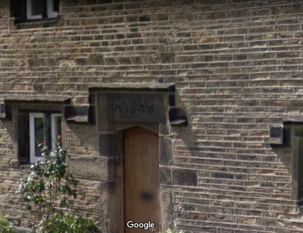
Next up, Hadfield Hall – a truly wonderful building. I could study this place for hours, and often find myself marvelling at the structure, and all the phases of construction. Now is not the time for a detailed look at the hall – a future post, perhaps. Still, it has a cracking datestone above the door.
I(J).H. T.A. 1646
Lovely stuff. Hadfield family? I’d love to know more – any thoughts?
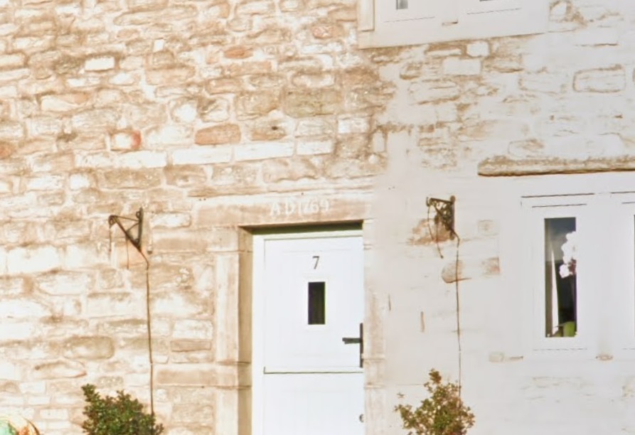
Just opposite Hadfield Hall is 7 Old Hall Square:
AD 1769
A simple date, rather than a chance at immortality.
Next we have 2 from Shaw, the farmstead that is first mentioned in 1285. It forms one of a number of such places dotted around Mouselow, and is a fascinating place. I suspect there is a lot of history here, and would love to have a poke around some of the properties there. If anyone reading this in Shaw fancies letting a slightly odd bloke have a rummage, so to speak, shout out!
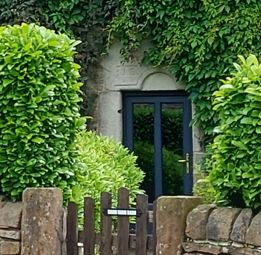
First is Shaw Farm Barn
G.B. (D) M.B. (B), 1694
Not a great photo, but the inscription is correct. It’s on a whacking great lintel, which is very suggestive of an earlier, perhaps Tudor, door lintel that’s been re-used. Makes you think… And then, next door, is Shaw Farm:
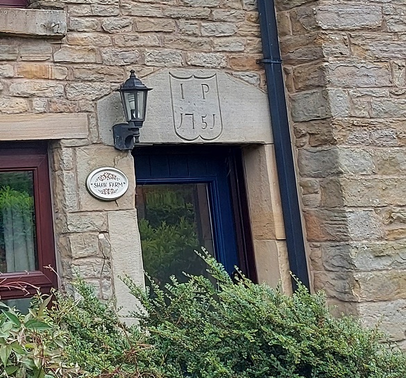
I (or more properly J).P. 1751, in a rather fetching shield motif.
The names here again escape me – J.P. (the ‘J’ is rendered as an ‘I’ as was the custom).
Next up, the Hare and Hounds, Simmondley.
G.B.P. 1784
I actually know the meaning of those initials – George and Peggy Booth. Also in Simmondley, we have Dingle Cottage which sits on the old trackway from the farms over Whitley Nab way.
M.L.R. 1706
A truly fascinating building, and again, one in which I wish I could have a poke around!
Next is Hall Fold Farm, Old Glossop.
J.S.J.G. 1806
The datestone was apparently found buried whilst the farmhouse was being renovated. The image is not mine, but was taken from the always interesting (and essential if you like Glossop’s history) Old Glossop History Trail website. I want to take one of my own, but oddly people view Herberts taking photographs of their houses with a bit of suspicion!
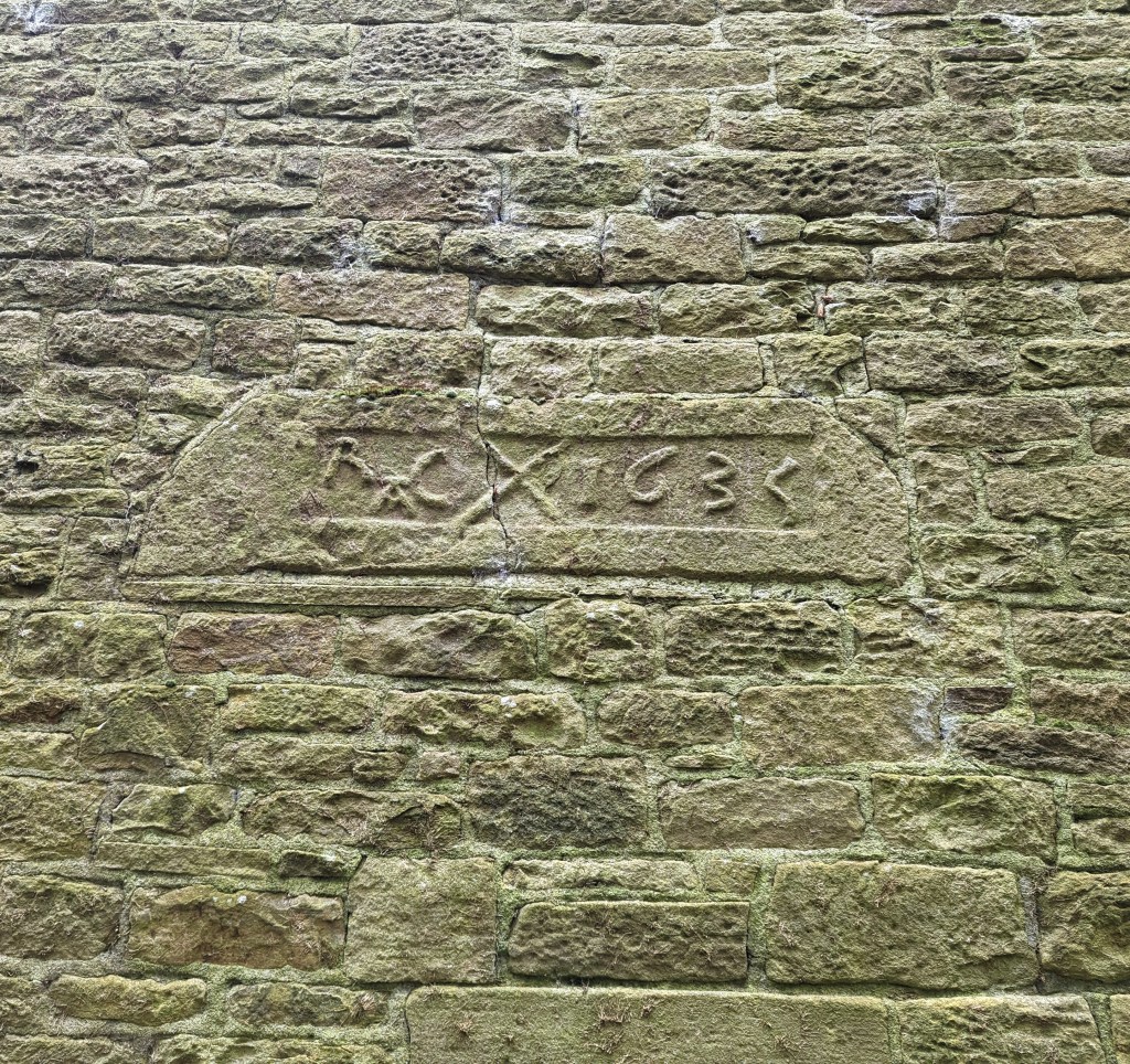
Another Old Glossop datestone is unusual – this is built into the side of Hillside Cottage, down by Laneside Farm:
R.A.C. 1635, with a decorative saltire.
A few things to say about this one. Firstly, it is the second oldest datestone in the Glossop area, pushing Hob Hill Cottage in Whitfield into third place. Secondly, the decorative saltire might also function as a protective motif, as the shape is a fairly commonly found apotropaic mark. But the important thing is that it is not in its original position, above a doorway, and in fact the house it is built into is late Georgian or early Victorian. I can only assume that it replaced an earlier building, and rather than throw the lintel away, the builders thought they might as well build it into the fabric of the house as decoration. As for the initials – I have no idea.
Next up, and finally: Flax Cottage, Wesley Street, Old Glossop.
S.W.E. 1783, and a little flower motif.
The flower motif in Flax Cottage is very similar to that at Hurstnook Farm – possibly the same stonemason carved it 11 years later?
Ok, so that’s it for datestones. There are others in the area – a few in Charlesworth, Herod Farm, Hobroyd Farm, etc. – but I don’t have photographs yet. If anyone does, or if anyone knows of any others that I don’t know about, then please give me a shout.
In other news. As I say, Where/When No.4 is about to be printed – I sent it yesterday, so it will be here next week, fingers crossed. I’m super excited about this one, and it might be the best yet. I’ll post more soon, and with other news too. But until then, look after yourselves, and each other, and I remain.
What ho, wonderful denizens of the blog reading world! How are we all? Well this is something of a to-do… what? Two posts in February? Truly I am spoiling you. Well, it’s about time I picked up the pace a little! I actually had a choice of about 4 half finished articles that I was going to go with, and I actually started working on all of them at some point in the last few weeks before I plumped for this one. Anyway, I hope you enjoy it.
So, I recently discovered the glacial erratic on Pyegrove Park. Now, I should clarify… I didn’t actually ‘discover’ it – lots of people already knew it was there, and in fact I already knew it was there, it’s just that I’d never been able to find it. But the discovery got me thinking: this blog is about archaeology, that is the study of humans and their history through the physical remains they left behind. And yet where we are, and how we live, and indeed how we have lived, has been dictated to us through the landscape, and our place within this. In short, there would be no Glossop without Longdendale, and there would be no Longdendale without the glaciers. So wrap up well, people… we’re off the the ice age.
Ok, so some background, and not being a geologist I really had to put in the homework here, so you’d best appreciate it! Honestly, my brain only has so much space in it: I once learned to ice skate and forgot how to use a knife and fork. What follows then is the ‘back of a fag packet’ version of the last period of glaciation (and before we move on, I must give a massive shout out to a superb website which really helped iron out some of the trickier bits – AntarcticGlacier.org – fascinating, well written, and aimed at non-specialists… well worth checking out if any of this interests you even in the slightest).
So then, there are three distinct periods of glaciation (that is, the process of glaciers forming and moving) within Britain – the Anglian (roughly 478,000 to 424,000 years before present [BP]), the Wolstonian (300,000 to 130,000 BP), and the Devensian (roughly 27,000 to 11,000 BP). Leaving aside the first two, lets focus on the last – the Devensian (also known as the Last Glacial Maximum), as this one was the only one that would have had anatomically modern humans living through it.
At this point, roughly 2/3 of Britain and Ireland, including all of Scotland and Ireland, most of Wales, and the north of England was covered by what is known as the British Irish Ice Sheet. Starting in the Arctic, as the land cooled this glacier moved further south until it reached a limit at about 27,000 BP, at which point the cllimate began to warm, and it slowly began to retreat, and was gone by 11,000 BP. The effect that this moving back and forth had on the land was catastrophic – carving out valleys (think the glens of Scotland, the Lake District, and even our own Peaks), and forever altering the land.
An awesome image of the extent of the Devensian Glaciation at its maximum. I make no claim to this image – it is all the work of Andy Emery at AntarcticGlaciers.org – I merely pinched it… this time with a little shame!
Now, here’s where it gets more interesting… and complicated. There are no definitive models, but it seems that Longdendale was at the southern/south-western edge of the Devensian ice sheet – the literal edge of the glacier in the last ice age. This might explain why the Peak District is, well… ‘peaky’, but the land to the west and south-west isn’t; Longdendale is the last valley before the land smooths out towards Manchester and Cheshire. Indeed, if you look at the above map and think about the landscape to the south and east beyond the edge of the ice sheet, whilst it can certainly be hilly, there are no peaks and steep valleys.
Of course, that’s not to say that the glaciers didn’t affect the land beyond that edge – already frozen solid and all but inhabitable, once the glaciers began to melt, the water had to go somewhere. There is some evidence for what are termed ‘glacial lakes’, huge bodies of meltwater, beneath or adjacent to the glacial edges. There seems to have been one covering the whole of Glossop as it is now – the landscape here being suitably bowl shaped – and which was perhaps dammed at the Mottram end with ice and clay. Not going to lie to you, folks, that honestly makes me feel… weird and terrified. Indeed, originally the Etherow ran to the west of here, toward Manchester, but was forced to change it’s course due to sand, gravel, and ice blocking the original route. And to give an idea of the power that such a lake bursting, one such steam blasted out the gorge (actually, a natural geological fault line) at Broadbottom which the viaduct now has to cross.
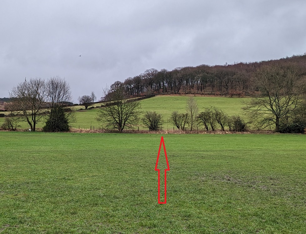
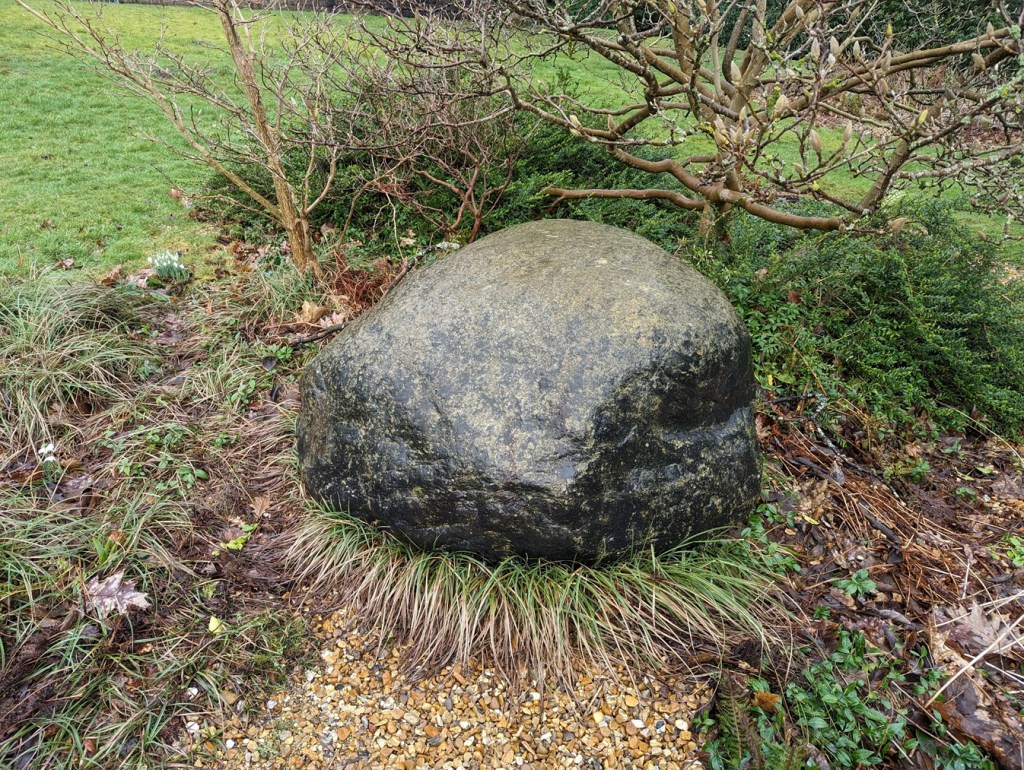
But the glaciers also gave another gift. As they moved up and down (and indeed round – there is evidence that it wasn’t a straight-forward linear motion), they picked up bits of geology – random stones and chipped-off bits of mountain. These they occasionally dropped as they went along in the form of what we know as ‘glacial erratics’ – defined by AntarcticGlaciers as “a far-travelled stone of a different lithology (stone type) to the local bedrock“. Now, the Glossop area has four of these that are known about (but there are a lot of odd looking stones dotted about that to my eyes look like they are erratics, but as I say, not being a geologist, I don’t know). If anyone has a geological speciality, or has any thought about the types of stone these are, and thus perhaps their origin, then please get in contact. The first of these is the one I have already mentioned at Pyegrove, here:
Roughly where the big red arrow is. Turns out the big red arrow is visible on the ground, too!
Lurking in the bushes, it hides its history well.
Using What3Words, it is located at easygoing.harmonica.ramming. Now, I’m not sure what to make of that!
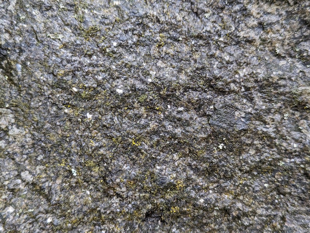
Now, other than it being non-local, and shaped rather like a large pebble (due to the grinding and rolling movement via glacier), I know nothing about it, geologically speaking. It’s coarse, with a sandstone-like structure, but not quite like any local stone I know of.
Close-up of the ‘fabric’ of the stone. It seems to be a type of rough sandstone – almost, but not quite like Millstone Grit.
I assume that it comes from geology further north than here, but where? Lake District? Scotland? Norway? Was this where it was dropped? Or has it been found in a field and moved? Possibly the latter, as it is on the field edge, and marks the track between Pyegrove House (and Hurst, etc.) and Glossop, now simply an overgrown hollow path at the edge of the field, but once an important route from Jumble, Hurst and Pyegrove to Glossop.
The sunken trackway – or holloway – worn by years of use.
Of course, it may be that the field boundary used the erratic as a reference point, and thus the track, but I still think it’s likely that it has been moved.
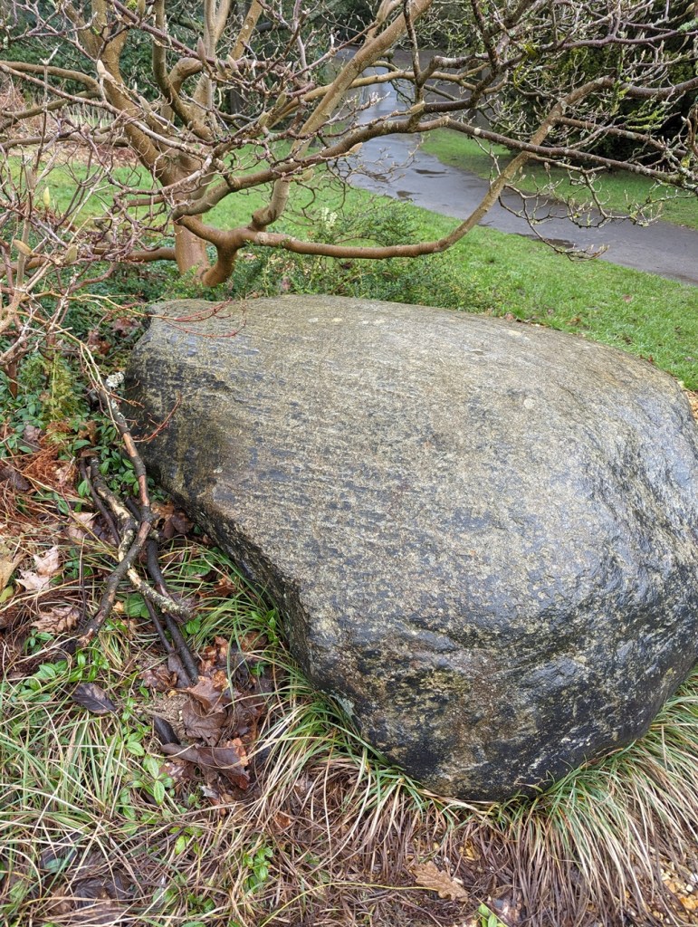
The next erratic is to be found in Howard Park, here to be precise:
Here, right in front of what was Wood’s Hospital, now Reuben’s Retreat. What3Words is overpaid.courier.recover. Lovely stuff. Also, looks like it has a moustache!
So, it’s a very similar stone to the Pyegrove example, possibly even from the same source. Here, in the close-up:
Not a million miles from the Pyegrove example.
The rock also shows very clearly the marks of being crushed and scraped along other rocks by the glacier.
Linear striations show how it was scraped along a surface… imagine the forces involved in this.Also much banged around – again, massive forces involved in this.
This one has certainly been moved, but from where?
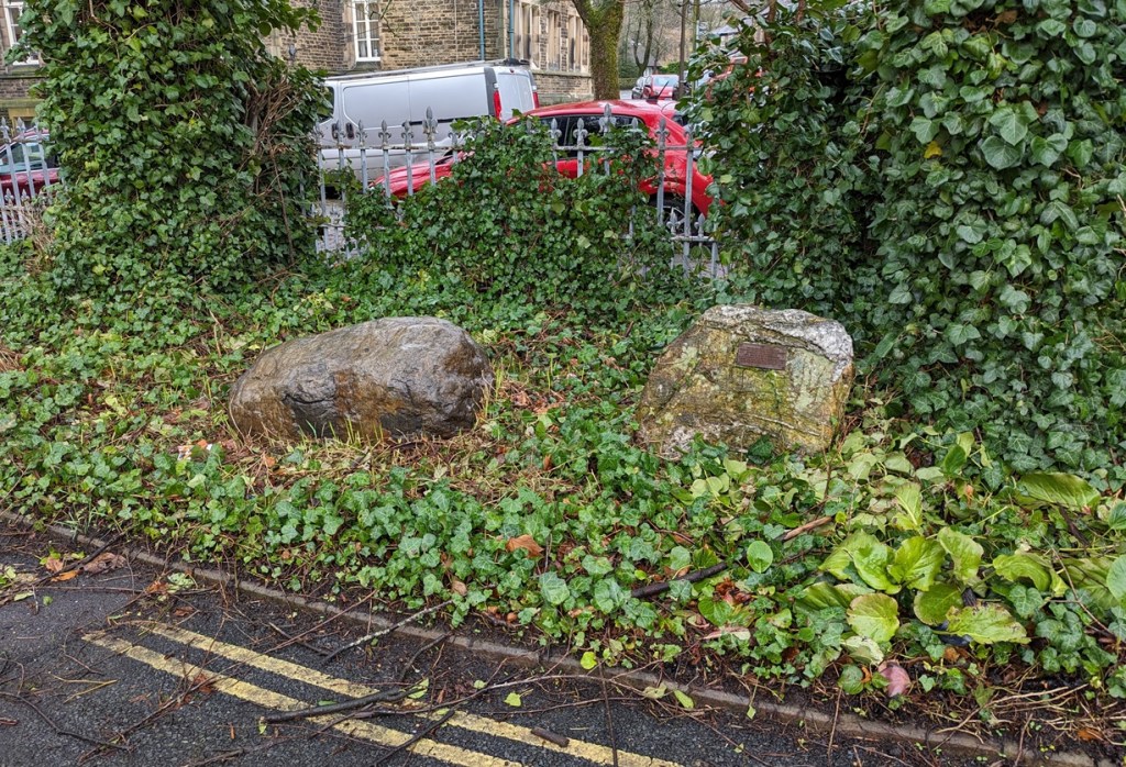
Our last two erratics are to be found in the grounds of the old Grammar School and library building, here, to be precise:
Against the wall of Fitzalan Street, and at earlobes.tutorial.daytime using What3Words… you couldn’t make these addresses up!Here they are in context.Smoother than the others, but again not local in origin.
Here it is is close-up:
Very much smoother. Very different from all the others, this one has quartzite in it, producing a much more jagged rock.
Here it is in close-up:
Very odd geology – a rough rock with striations of quartzite… probably quite unremarkable to a geologist! Possibly related somehow to Shap Granite which has similarities. I think.
They even have a plaque helpfully explaining where they were found, and potentially where they originated.
Shelf Brook… well worth checking out, apparently!
As the climate began to warm up, the land began to come back to life – this was the start of the Holocene period, the modern human world. Trees, shrubs, and plants started to grow, and these are soon followed by the animals that eat them. And following them, hunting and gathering, people. By probably 8000BC, at certainly by 7000BC, people were passing through the Glossop area following game in small bands, and moving between seasonal hunting camps. Their movement through the area may have been part of a cycle of many years, and many hundreds of miles from place to place, stopping for a period of months – summer in the higher ground, winter in the warmer valleys – meeting other groups in specific locations, trading resources and marriage partners, and moving on again, through a landscape that was marked only by natural monuments. The Mesolithic (Middle Stone Age, c. 8000 – 4000 BC) is a fascinating period, but we know so little of their daily lives. Indeed our only clues to their existence hereabouts are the flint tools they made and used, and which are quite commonly found in the hills around Glossop.
Some lovely Mesolithic flint bits. Left, a small scraper; middle, a core from which tiny blades (microliths) were chipped or knapped; and right a notched blade which are common in the Mesolithic, but which no one seems to know what they were used for. My guess would be to scrape down arrow shafts. To be honest, flint tools are like Swiss Army Knives – multiple uses in multiple ways.
I’m also going to use this article to put to bed a story I’ve heard from several sources over the years – that Coombes Edge is a caldera – the blown out remains of a long dead Volcano. Essentially, a smallish volcano erupted, and blew out the north-western side, spewing it’s contents over towards Hyde. This is not the case, and the unusual land formation is the result of a huge landslip caused by under soil water movement, and which occurred sometime between 10,000 and 7,000 BP – so somewhere in the Mesolithich period. One wonders if the landslip was noticed by anyone, either as they were nearby, or after they came back into the area and found the huge landslide. And I wonder what they thought of it.
Also, I wonder if we have a look in Shelf Brook, but other streams around here, we might find some more glacial erratics, large and small. Who’s with me?
Right, I’m off to light the fire… and pour a glass of the stuff that warms.
In other news.
There will definitely be a guided archaeological & historical (hysterical?) walk in the next month or so, so watch this and other spaces for news. This will probably be just before the new edition of the Where/When zine – No.2 – comes out. I have decided to aim for 3 zines a year – December, April, and August, but I want to be flexible on this… my life is hectic enough as it is! I’ve also got some ideas for some special editions, but that’s far in the future. In the meantime, who wouldn’t want a Where/When t-shirt with the slogan “What ho, Wanderer!” on it? Just a thought!
As usual, keep in touch, even if it’s just to tell me I’m talking out of my hat. So until next time, look after yourselves and each other, and I remain.
(Will I make it before January 31st?.. that is the question)
What ho, wonderful people, what ho!
And my how I have missed you all. Well, most of you at least. Not you Mr Shouty-Outy, nope. But surprisingly today’s offering is pottery free, so you have no need to say anything at all.
So then, Christmas is over, and the New Year’s hoohah is done with… alas. Invariably at this time of year, a certain sombreness overtakes old TCG. Gone is the ‘devil may care’ attitude of yore, and instead a certain ‘not even the devil cares’ feeling overtakes one’s bean. There is a noticeable drooping of one’s shoulders, a subtle sadness of the ‘O the pain of life‘ variety, and a distinct lack in the old J de V. A funk, if you will, the like of which even the stuff that cheers – if taken in the correct dose – fails to cheer. Not that it stops one from trying, obviously.
And so, trying to raise my spirits, I found myself idly flicking through the wonderful History In a Pint Pot by David Field, which is a detailed history of all of Glossop’s pubs, past and present. Highly recommended, but sadly long out of print, athough the library has a copy if you want a read… and you should. I was looking at my local, The Beehive, when at the back of that particular entry was an old advert dated to sometime in the Victorian period that looked vaguely familiar.
Beers, wines, spirits, cigars, horses, stone… there’s not a lot that can’t be bought at the Beehive.
*Ping* went a synapse… a second passed… then *thunk* went a receptor (I may have slightly overdone the festivities this year, and the old noodle is functioning at approximately half normal speed). Where had I seen it before? And why was the advert significant? What? Where? When? And then it hit me… St Mary’s Road. Oh yes… something I should have blogged about before now.
Sooooo… a few years ago someone messaged me via, I think, Twitter, and asked if I had seen the name carved into the the gutter of some houses at the top of St Mary’s Road, and did I have any information.
Before we go any further, confession time. I am, as you might have realised, quite good at some things (*cough* pottery *cough*) and terrible at others (*cough* communication *cough*). I am also fairly disorganised in some areas (*cou… YES, alright, we get the picture… here, have a throat sweet). So it should come as no surprise to anyone that I cannot for the life of me recall who it was, nor can I seem to track down any record of the conversation. So if it was you, then please accept my humble apologies, and step forward to make yourself known and famous to all 7 of the people who read these posts (including Juan in Venezuela).
So then, had I seen them? No. And had I any information? Also no. And so it was I found myself walking down St Mary’s Road, muttering to myself as I am wont to do.
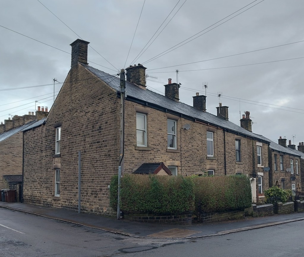
No’s 116 to 122 make a small terrace of four stone-built houses, typically mid-late Victorian in shape, and are much like all the others around them.
The corner of Duke Street and St Mary’s Road.
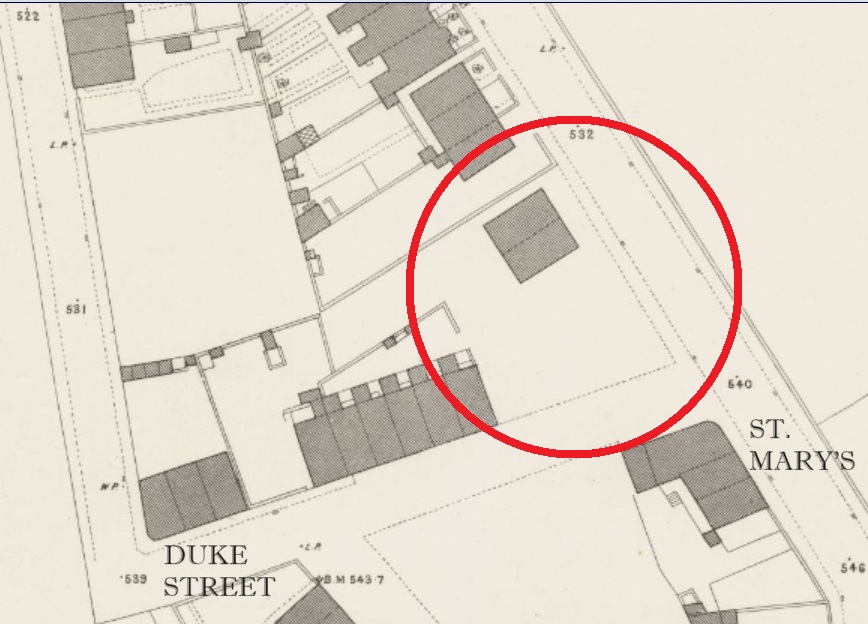
They don’t appear on the 1880 1:500 OS Town Plan
The lack of houses is circled in red, with St Mary’s running broadly NW-SE. Map stolen, as usual, without shame, from the enormously useful and always fascinating National Library of Scotland OS map database. Check it out here.
But they do appear on the 1898 25 inches to the mile OS map:
You can really see the map filling up, and a real sense that Glossop is still filling out to its Victorian and early 20th century maximum. Map stolen as per above!
Which gives us a date of between 1880 and 1898 for their construction.
So about the name, then. It took me a moment or two to see them, but at the end of each of the corbels that hold up the guttering, you can see a letter or character.
Apologies for the darkness of these photographs… I didn’t realise quite how murky they were until they
Wow! I love this, and I cursed myself for not noticing them before – serves me right for always having both eyes on the floor! It is difficult to photograph these without a telephoto lens, but also without attracting the ire of householders, who oddly don’t like it when you stand around taking photos of their houses, usually muttering threats of ‘setting the dogs on you’; people are strange. Anyway, the best I could do is the following stream of photographs; apologies in advance!
J O H N+ T R UE M A N .
So then, what do we have?
J O H N + T R U E M A N 0
Nice! A mystery. There is very little relevant online, but there was a reference to a John Trueman as the publican of the Beehive Inn in Whitfield, which was worth following up, and hence the History in a Pint Pot advert. The connection is not immediately obvious, but the fact that Trueman was mentioned as both wine and spirit merchant, and a stone dealer in the advert suggests that he built the houses, and probably using his own stone. It seems that the position of publican of The Beehive (or ‘Bee Hive’, as it was then) came with the rights to the quarries at the end of the track beside the pub, next to Fieldhead Farm there.
The Beehive is arrowed in red, but you can see the track leading to the quarries at the end.
William Miller, the landlord in 1857, is also described as a stone dealer. Our man John Trueman was landlord here between 1871 and 1894, which is also spot on for the date of the houses. I like the idea of him wheeling and dealing, serving pints and stone in equal measure. And if you build houses, then why not go ahead and sign them, particularly in a rather cool way. There seemed to be a lot of that around at the time, and as I was walking away from St Mary’s, I remembered another named building that I’d like to take a look at – Norfolk Buildings on Victoria Street:
Norfolk Buildings and The Surrey Arms
According to Robert Hamnett, The Surrey Arms and the three adjacent houses in the terrace were built in 1846 by James Robinson, who owned a large number of houses (and presumably having built them, too). You can see the uniform design and decoration of these three, especially in comparison with those buildings to the left, which are smaller and built to a different design. You can also see the ‘join’ between the two groups. It seems that these houses were constructed later that Norfolk Buildings, and presumably by a different person – again evidence of the piecemeal process that characterised Glossop’s Victorian building boom. The name/datestone is above the centre of the three houses:
I wonder if ‘archaeologist‘ would hold up in court as a defence against being accused of being a ‘peeping tom’. An academic question, obviously… purely theoretical.
‘J.R. NORFOLK BUILDINGS 1847’
The ‘J.R.’ is presumably James Robinson, and the buildings named after the Duke of Norfolk, whose investment in the town was arguably at it’s greatest in the mid-19th century. The date speaks for itself, though Hamnett notes that the lease for the pub dates from 28th March 1846, so this might be a lease connected with the land itself, or perhaps the proposed pub.
So there it is, this month’s offering… and I made it in January! There are so many Victorian datestones in the Glossop area, many recording details beyond just a date, and we find house names, builder’s names, area names, and the like. I’d like to do another survey of datestones or name plaques for the Victorian period, to accompany the one I did (and is still ongoing) for the pre-Victorian period. Or, you know, convince one of you to do it and publish it on the website (if you fancy the challenge, give me a message). Anyway, more again very soon.
In other news, the first issue of Where/When is back in stock. So, if you fancy a guided Wander from the Friendship Inn to The Oakwood, via Ashes, Dinting, Adderley Place, Pikes Lane and Harehills, and through the prehistoric, Roman, and medieval periods, then this is the publication for you… especially if you like what you read here!
You can download a free copy here, but there’s nowt like a physical paper copy: £5 from Dark Peak Books, on High Street West on Glossop (and I might be the one to serve you!), or you could just ask me, and I’ll bung one to you. For those that have been asking, Issue 2 is on the way… and honestly a fantastic one it’s going to be.
I’ve also got a few actual different Wanders planned, real actual physical walks led by yours truly, up hill and down dale, and through our amazing shared historical landscape. You can even throw stones at me when I start to bore you about pottery… and no, that doesn’t mean you can sign up for it just to lob rocks at me, Mr Shouty-Outy. Anyway, watch this space as I’ll advertise it her, and elsewhere.
So that’s about it for now. Hopefully I’ll get a couple written for February – I have so many half-finished articles it’s ridiculous, and I just need to get on with it (lots of pottery goodness!). But until then, look after yourselves and each other, and I remain.
Nope, no pottery today. Instead we have tracks. And stones. And holes. Look, just read on… it’s simpler.
Now, I do love a good track. Ask anyone who knows me, and they’ll say “why yes, that ruggedly handsome, wonderously whiskered, and all-round splendid chap does indeed love a good track or two“. I also love a good stone. In fact, ask anyone who knows me, and they’ll say “why yes, that marvellous man, that genius gentleman, that… ” What’s that? What do you mean “get on with it!“? Honestly.
Ok, so several years ago I noticed that dotted around the Glossop area are a number of standing stones that have holes carved in them. I did wonder about them, but presumed they were a form of gatepost, even if they didn’t seem to be in a place one would expect a gatepost.
A holed stone on Hague Street. They remind a bit of Hattifatteners from the Moomin stories… they probably come to life at night.
More recently I have been looking at tracks:
TRACK (noun) A rough path or road, typically one beaten by use rather than constructed.
And more specifically, the old – medieval or post-medieval (10th – 17th centuries) – trackways that dotted the area. Glossop is a great example of what we call a medieval ‘dispersed settlement’ – essentially, whilst there is a central focus – Old Glossop, with the church and market – most people actually lived in the many surrounding ‘dispersed’ farmsteads – Heath, Dinting, Ashes, Jumble, etc. People came together every Sunday for Mass, as well as other feast days and holy-days, for market days, as well as socially – for a drink in the tavern, for example. But by and large, Glossop in the medieval and early modern periods was dispersed throughout the valley in farmsteads. In this instance, a farmstead may be understood as a farmhouse and associated buildings – barns, shippons, and various ‘farm-ey’ outbuildings – as well as houses for the farmworkers. In total, we’re looking at perhaps 20 people or so for a larger farmstead, maybe 5 for a smaller. Of course, people need to travel, and roads were made through the landscape, connecting these farmsteads, and it these I incredibly interesting.
This is the track that runs down from Ashes to Dinting – once the main thoroughfare, now a beautiful sunken trackway, or holloway as they are known, its age is shown by its depth, worn through use.
They were not just a means of physical movement through the landscape, but also a conduit for other aspects of life. As packhorse routes (no horse and carts here, just heavily laden beasts of burden) they connected everybody, and allowed goods and produce to move between places and markets. News of the wider world also moved along these tracks – a new king or a new religion, or news of battles and wonders in far off places. But so did disease and infection; the Black Death and Great Plague once walked these tracks. We also encounter the more local and personal aspects of life, too: newlyweds from church, newborns from baptisms, and the final journey from the farmstead to the church yard, as the deceased was carried for burial, often for miles, along the tracks, followed by mourning family and friends. All of life is contained in a track, worn deep by use, and all of history held there, if only we could access it.
However, the collision of stone and track didn’t connect until last year, when it occurred with an audible click at Pyegrove.
Pyegrove circled in red. For orientation, the Snake Pass runs horizontally across the bottom, with the Commercial Inn on Manor Park Road circled in blue on the right, and the Royal Oak, left. Note the green arrow. Map from the marvellous and incredibly useful National Library of Scotland map website – well worth an explore.
An afternoon playdate with Master Hamnett and his friend led us to Manor Park via Pyegrove. Now Pyegrove is an interesting corner of Glossop, with a long history; the name means the copse or thicket’ (grove or greve, as it is in older maps) of the magpie (the ‘Pie’ or ‘Pye’ element) which suits its location below Shire Hill perfectly. The house here has a datestone that reads “I.M.A. 1747” (no photographs, alas… it’s difficult to even see it without overtly trespassing), so that the house is at least that early. However, in the baptism record of a John Shepperd at Glossop on Christmas Day 1735, his father (Robert Shepperd the Younger) gives his address as Pyegreve, so we know something else was there at an earlier date. Pyegrove is, I suspect, another medieval farmstead… but all that (along with tales of Buffalo Bill) is for another time. Let’s return to tracks and stones.
The footpath at Pyegrove splits – right skirts Shire Hill down to Mossy Lea, left ploughs on over the playing fields to Glossop.
Tarmacked, unlike the original, choose your path wisely.
But just at the split I noticed this:
Oooooh!, thought I – a holed stone…
It was at that point it suddenly struck me, and as I stood there gasping like a stunned fish, ignoring the children, and mentally ran over all the holed stones I knew about (5 at that point). Of course, I thought, they all marked a junction in a footpath or track! And all of those tracks, I was fairly certain (and am now convinced) were the preservation of early (medieval or post-medieval) trackways between farmsteads. I have talked about this before – the fossilisation of early trackways, preserved as footpaths within modern settings, but in essence once the newer – and much better – roads were constructed for the mills (1790’s onwards), these old roads fell out of use, but as they often were more direct, and were known by locals who still used them, they gradually became public rights of way.
The stones, being big and heavy, are often not moved, so there they sit as testament to the tracks that were once the main roads between the dispersed settlements that made up Glossop. I know of 9 holed stones now (and two more that might be relevant), and looking closely at the stones, they all share similar aspects. Upright, and roughly shaped from millstone grit or similar gritstone, and they seem quite worn – usually an indicator of age. The hole, made through the stone, is broadly square in shape, measuring between 3 and 4 inches across, roughly carved, and placed in the top third of the stone. I am convinced they were shaped and set up by the same group of people to make using the notoriously bad road system around Glossop easier. Of the stones, the obvious question is why does it have a hole in it? My first thought was that it would mark the stone as different from others that might be in the area, making sure that a junction wouldn’t be missed in the dark or bad weather. This might be the case, but then I remembered reading that in 1693 a law was passed that trackways had to have a guide post showing destinations (the Whitfield Guide Stoop was a result of this law, but probably a later incarnation), and I wonder if the hole was there to allow a wooden sign to be placed in it with destination painted or carved on it? Or perhaps a simple stick pointing the way? Any thoughts on this, o’ wonderful readers? I also wonder how far this tradition continues – certainly I know of no others in surrounding areas – even Tintwistle or Hadfield, for example, seem to have no holed stones, although I’m happy to be proven wrong. .
But let’s have a virtual explore the Pyegrove to Glossop track here, starting at the stone that started it all.
Ignore the later drilled circular hole, and the rusty bolt through the hole – this is a classic junction marker, with its ‘square’ hole and rough shaping.
Ignoring the A57/Snake Pass (opened in 1821, although bits are older), behind us is what is now Derbyshire Level, with the farmsteads of The Hurst, Jumble, and Gnat Hole, and also the road to Whitfield and Chapel en le Frith. Going left, then, a track along the edge of some houses leads out into Pyegrove Playing Fields.
Looking back at Pyegrove, the overgrown track hides what was once a main thoroughfare into Glossop. O’ for an excavation of this track!
Along the northern edge of the playing fields the track is no longer used, but is visible as a ‘holloway’ – a track worn deep with use.
Here is the Holloway, Green Way, or sunken trackway, depending on how you call it. Do you known what, it’s oddly difficult to photograph a dip in the field, but it is there… honestly!
We join the track again at the corner of the playing field, where there is a lovely squared off standing stone.
A simple standing stone, if such a thing exists.
This seems to mark the junction of a track that originates at Cross Cliffe, here marked in blue:
The trackway is visible in the older maps, and although it fizzles out on the ground, it is preserved in field boundaries and fossilised in strangely preserved bits of pathway.
Whilst it is just about marked on older maps, it is no longer in use, although its memory is fossilised in this bit of unnecessary and unusually wide stretch of pedestrianised path leading from the Snake Pass to Pyegrove Park (marked with a red circle in the above map)
Oddly wide, and completely unnecessary, this is the fossilisation of an older track from Cross Cliffe.
These simple – unholed – standing stones sometimes mark junctions, but more normally simply mark the line of a path where is might not be obvious, particularly in the dark or rough environment (I know of about 12 of these, too).
We continue along our Pyegrove track beyond the stone and past the remains of the Royal Observer Corps station. Briefly, the station was meant to monitor potential enemy aircraft in the immediate post-WWII period, but it would also serve as a monitoring post, observing and recording the effects of any nuclear detonation on Manchester – wind speed, radiation levels, blast radius, etc. This is why it is built into the hillside, 15ft below ground level. A sobering thought, and one sadly now relevant once more. This will also be the subject of a future blog post, don’t worry!
An interesting slice of much more modern history, but one that is certainly worth a look at .
Back to the task in hand, and on to another standing stone. This one, looking for all the world like a gravestone, was originally one of a pair (its partner is embedded, horizontally now, in the wall.
One of a pair – the other can be seen lying horizontally built into the wall – same stone type, same width, same depth, and presumably the same length, accounting for a few feet underground.
These gravestone pairs are usually found mid track or at the start of junctions, and seem to be a later addition to the tracks (probably post-1790’s) and seem to be an attempt to force packhorses and traffic onto the newer roads (and presumably so they can pay the tolls) – and early form of traffic calming, if you will. I am fairly certain with the date of c.1800 as Whitfield Cross was used as a partner to one of these ‘gravestone’ pairings after it was moved in about 1800. There is some graffiti carved on the top of this stone – ‘G.B.’.
G.B. step forward and take a bow – I do like a bit of carved graffiti.
From here we continue, round the corner, to the farmstead of Hall Fold.
Converted barn and outbuildings of the farmstead of Hall Fold
A datestone here records ‘J.S.J. 1806’, but this was apparently found when the owner was digging a foundation, and clearly Hall Fold Farm is older that that.
Not my photo – stolen shamelessly from the Old Glossop website, which has a bit of history and a series of very interesting photographs of Hall Fold Farm – here.
The name itself may refer to a long demolished, possibly medieval, original Glossop Hall (Manor Park Road was once known as Hall Street). This is also the location of a junction – our track is joined from one that comes from Whitfield (an extension of this one).
A fork in the track!
Our track from Pyegrove is on the left hand, but the one from Whitfield comes via Old Glossop Cricket Club, and would have come through the gates ahead. Though no longer in use, its presence is preserved in field boundaries and the fact that these houses (c.1830’s) respect the track, which is why they are built at that strange angle. It’s also visible in LIDAR under the cricket pitch.
Sadly, no marker stone remains at Hall Fold Farm (although I didn’t start poking around people’s gardens, and it may well be lurking somewhere – large stones are hard to completely lose). From here, the medieval centre of Glossop is a hop, skip and a jump… if you are feeling so inclined.
I have to say, though, walking into Glossop this way is a much more interesting – and authentic – experience, and one that is very different from walking along Manor Park Road! We take our modern roads for granted, and I’m not going to lie – the idea of moving along these tracks in bad weather and in darkness fills me with fear.
This is a small part of a much larger project I’m working on, tracing these tracks all over Glossopdale. Each of the settlements that make up ‘Glossop’ – from Wooley Bridge in the west, to Pyegrove in the east, Tintwistle at the north, to Chunal in the south – have multiple tracks linking them, and for the large part they are still there, often hidden, occasionally ‘fossilised’ as footpaths, or even still in use. This is truly an overlooked, and indeed largely undiscovered, aspect of Glossop’s pre-Victorian/pre-Industrial history, but one that was vital to its development. And I have to say it is great fun being able to walk these ways, and pondering the history they hold – if anyone fancies joining me, give me a shout. Also, and this is a serious request, if anyone knows of any holed stones (or any standing stones, for that matter) that I might not know about, please do get in touch – often half hidden in hedgerows, they will lurk where two or more tracks join.
Right, that’s all for now. More pottery next time (did anyone else hear that high-pitched screaming sound?), but until then look after yourselves and each other, and I remain,
Well that got your attention! What ho, wonderful people! What ho!
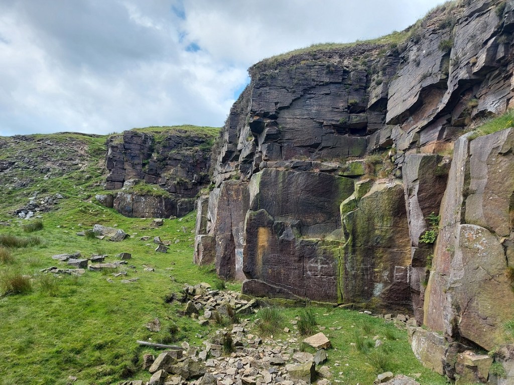
Up by Coombes Edge lies Cown Edge quarry. This quarry, long disused, contains a number of interesting, and oddly well executed, carvings on the walls. I have heard about this particular place – and its carvings – many times, and from many different people, but had never managed to get up there. No reason, simply that there are so many places to see, and so little RH. A few months ago, a friend (my thanks to Andy T) suggested a walk up that way and, well, I thought, let’s have a look.
What I like about this place is not just the ‘historical’ history, which is visible and tangible, but the ‘personal’ history which is similarly visible, but often better felt than seen. The quarry seems to be one of ‘those places‘; a destination, a space in the landscape that attracts; a shelter, an asylum, a place of freedom, and perhaps decadence. In particular, it’s place where ‘youths‘ go and be ‘youthful‘, frolicking, feeling, fumbling, and… well, you get the picture. I didn’t grow up in Glossop – I’m a ‘comer-inner‘, so to speak – but if I could take you to Cheadle Hulme where I did grow up, I could show you a few such places from my youth. Every town & village has them – and the similar stories they could tell of the first time drunk, illicit substances consumed, virginities lost, love discovered, best friendships forged, fights fought, and the always difficult transition from child to adult negotiated – often on the same evening. But perhaps most importantly, memories are made. To quote Wordsworth “Bliss it was in that dawn to be alive, but to be young was very heaven“. I have recently turned 47 (young for some of you, old for others… it’s all relative), and have been marvelling at the swift passage of time, so forgive the nostalgia. Now on with the show.
Cown Edge Quarry seems to have been started sometime in the early 19th Century, probably as a source of roofing stone. Geologically, the stone is Rough Rock – a type of sandstone of the Peak District and southern Pennines, and the most commonly occurring of the Millstone Grit group.
Incidentally, and as a rule of thumb, you can roughly date the buildings of Glossop by what the roof is made from. Prior to c.1850 roofs were made from stone taken from local quarries such as these. However, once the railway arrived (c.1850) Welsh slate could be imported on trains. Not only was slate cheaper, but it also weighed less so the roof could be constructed using less timber, and so roofs after 1850 tend to be made of this. A rule of thumb not an absolute guide, but useful nonetheless.
Anyway, the quarry is located here:
Thank you Google for the image.
And here it is in 1898:
And thanks to the National Libraries of Scotland for this image.
If you use the What Three Words app, the reference for the quarry entrance is: tribal.workers.crossword
Now, as subjects go, it isn’t perhaps the most interesting, but then as we know on this site more than most, ‘interesting’ is a veeery subjective word. However, it was deemed important enough to have its own Historic Environment Record – MDR10021. Largely overgrown now, and with none of the urgency and noise that would have marked it out as a place of work when it was operating, it is peaceful and still.
The view looking north from the quarry mouthLooking west. Interesting, and a little odd, to think that the roof of my house, where I type these words, was almost certainly quarried from this place.
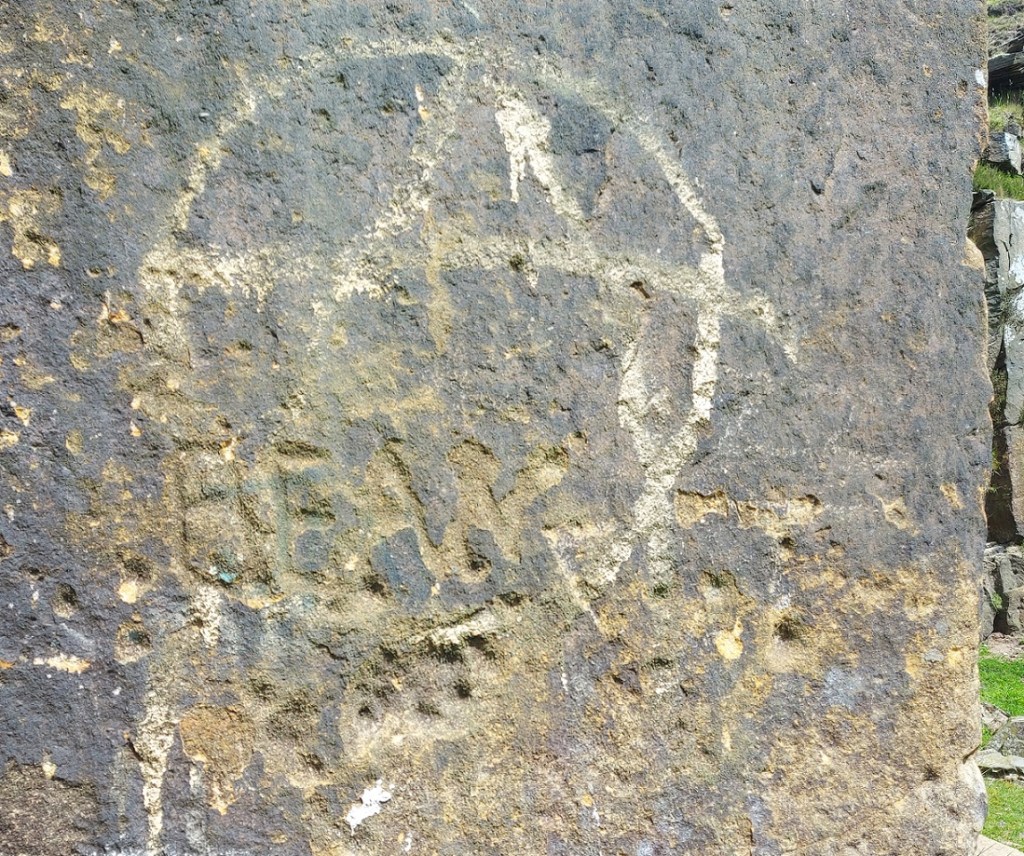
However, the walls are full of interesting graffiti, carved over the years since the place was abandoned. Some is more worthy than others, but all is a record of people, humans being, well… human. I have said elsewhere that there is something universal about the need to leave a mark on the environment, almost a way of achieving immortality, your name living on past you, perhaps. And hats off to those who did it before the invention of spray paint… if you wanted to put your name up in the past, you had to mean it – with a hammer and chisel. Here follows a sample of the carvings – mundane, as well as the more creative.
AKW 1942 – presumably there is no reason to lie about the date, so this is interesting… and asks further questions. “Tim. Joey. Glossop”?“.D” – quite modern, I suspect, and a worn hole. “BEAN”? and some pock marks. These overlay – and are later than – the painted anarchy sign. “DUF, LEZ, ANT, GUS” 1994. “KEV” at the bottom is even probably even more modern. “DAN”, “SID”, “LES”, “LYNN”, and some symbols. These seem to have been carved and re-carved.
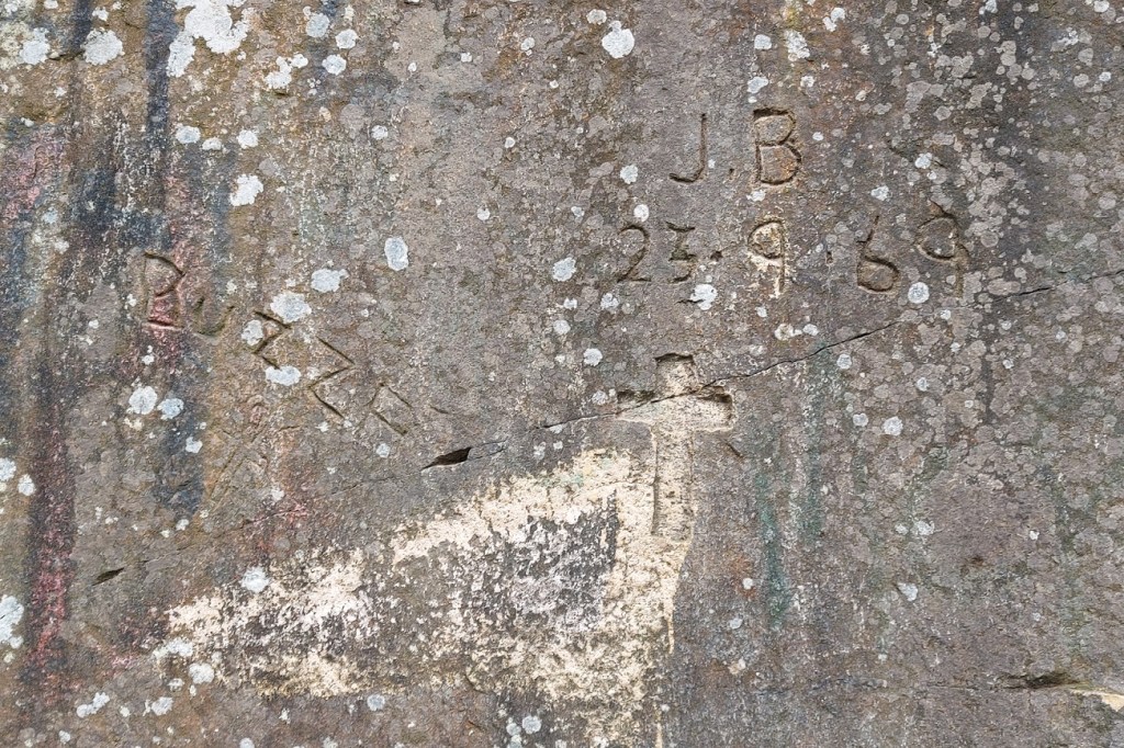
Talking of symbols, there are what seems to me an unusual number of Christian crosses carved here:
“BUZZB” and “JB 23.9.69” I love this one – the date is so specific. The cross is also very prominent. An ancient Egyptian Ankh symbol – quite old (filled with slow-growing lichen), and odd to find on the rock face.Another lichen-filled cross.
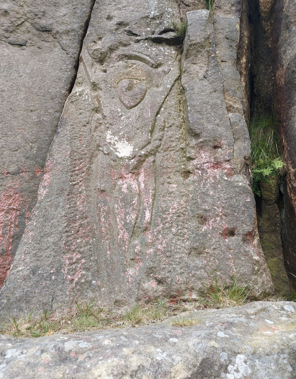
Perhaps it’s the crosses that give the quarry its reputation for Satanism and witchcraft? Anyway, the ‘religious’ iconography culminates in this, what the HER calls “a potential Calvary figure” – that is, Christ on the crucifix:
Well executed, and subsequently highlighted in paint.
This is a weird one – is it one figure, or two – a smaller, more feminine and naked, between the Christ-like figure’s legs? Or is it three? The more I look, the less I know. Is that the point? Is there a point? Even down to the almost-altar like outcrop of stone in front of the figure, this is very good.
It seems that this is a modern(ish) rendering, done by a known person – I have heard several different reasons and accounts – and people – but the story is not mine to tell, nor is it for me to name names. That I will save for the comments section, should anyone wish to do so.
However, it looks like it was the same hand that carved this naked lady, as well, so I’m not sure about any religious motivation as such:
It’s carved with skill, too.
There’s also this lower half of a person on their hands and knees.
Not sure what I can say about this… so I’ll say nothing!
Moving away from carvings, and back onto the safer territory of history and archaeology, there are traces of the original purpose to which the quarry was put here and there amongst the more modern intrusions.
The rough dressing is visible in the dark area of the quarry face.
Here we can see the rough dressing of the stone, done prior to it being broken out of the rock face. This provides it with a flat-ish surface before it is smoothed properly elsewhere. This was probably the last thing that was done in this quarry before it was shut down, as it is part of the quarrying process, but was never finished. I like that.
The quarry road, with spoil piles on the left.
The quarry road is very nicely preserved, but if you look closely at the stone at the bottom of the above photograph, you can see a groove worn into the rock there, running top to bottom. This is the track of a sledge repeatedly being drawn over the stone, day in, day out, for decades. A horse-drawn sledge is easier to use, more stable, and less likely to cause accidents, than a cart, and were often used in these remote quarries.
I also found also a concretion in the rock face of the quarry. Essentially, a concretion is a small boulder of one type of rock which is formed naturally, and which becomes trapped within the matrix of a surrounding rock when it was laid down as sediment millions of years ago.
I love that the concretion looks like an eye, the ‘eyelid’ accentuated by the red paint.
The concretion erodes at a different rate from the surrounding material, and so they stick out quite clearly. They’re fairly common in this type of Rough Rock, as indeed are plant fossils, apparently, but I didn’t see any of those… I need to go back.
Right, there you have it. More soon – including more pottery, you lucky, lucky, people. I’ve got so many ideas – walks, books, tours, blogs posts, pottery workshops, YouTube shenanigans, surveys, excavations, art, creativity, etc. – and so much I’d like to do. For now though, stay in touch and follow me here, or on Twitter (@roberthamnett), or even on Instagram (timcampbellgreen). Or just come up to me and say “What ho, Robert Hamnett!”.
But until next time, please look after yourselves and each other.
Ho! Ho! And if I might dare, What Ho! A shortish one today, and actually one that is something of a relief, if I’m honest. Like the last post, this one has been years in the making, but this time for all the wrong reasons… all will become clear in a moment, but for now let’s crack on.
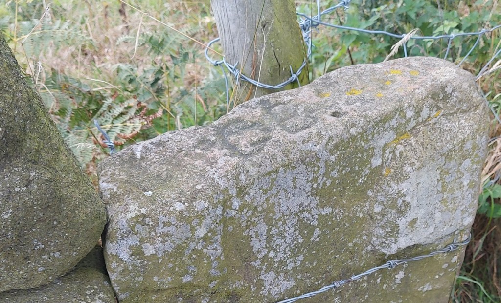
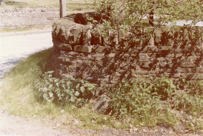
As the title suggests boundaries are today’s topic, apt as we hurtle to the Winter Solstice and the shortest day – that anciently observed boundary between the old year and the new. Boundaries such as these are often held to be dangerous places as they are a liminal space – neither one thing nor another, but somewhere in between. However, boundary stones in particular I find fascinating and strangely appealing objects; there is something very grounding about them in that they mark in a clear, permanent, and fixed way, an imaginary line. On one side ‘X’ and on the other ‘Y’, and there is no argument – the somewhat liminal boundary is made visible and real, and so it is the case with our stones today – three stones placed on bridges over various waterways delineating the townships that make up Glossop
All three, it seems, were carved and installed at the same time, and all are quite old – early Victorian. The first of the stones is the easiest found – Victoria Bridge in the centre of Glossop.
Station at the top, above the High Street crossroads. The bridge over Glossop Brook, and the stone, is circled in orange. Glossop is north of the Brook, Whitfield is south.
And here it is in real life.
Victoria Bridge. Wetherspoons is in the background, and Glossop Brook runs beneath.
The bridge, and the stone, stand over Glossop Brook, which disappears under the market place and carpark, and the line carved between the words Glossop and Whitfield is the centre line of the brook below. Victoria Bridge was built in 1837, the year Queen Victoria ascended the throne, hence the name. This new bridge replaced an old and narrow hump-backed pack-saddle one. Indeed, the original line of the road that led over the bridge, down Smithy Fold, and along Ellison Street is traceable, and is preserved particularly in the buildings of the Brook Tavern, Cafeteria, Glossop Pizza, Balti Palace (all built in 1832). I have a blog post almost finished that looks at this area in more detail, so I won’t go into it here.
Looking closely, the inscription “Victoria Bridge” and the date “1837” are in a different font and slightly larger than the other lettering on the stone, and are more cramped, and it seems they were added at a later date. Indeed, compare this stone to the one below, and you can see they both once looked the same.
And of course, it wouldn’t be the Glossop Cabinet of Curiosities without a bench mark, this one on the bridge and just to the left of the boundary stone.
This is what 495.7 ft above sea level looks like.
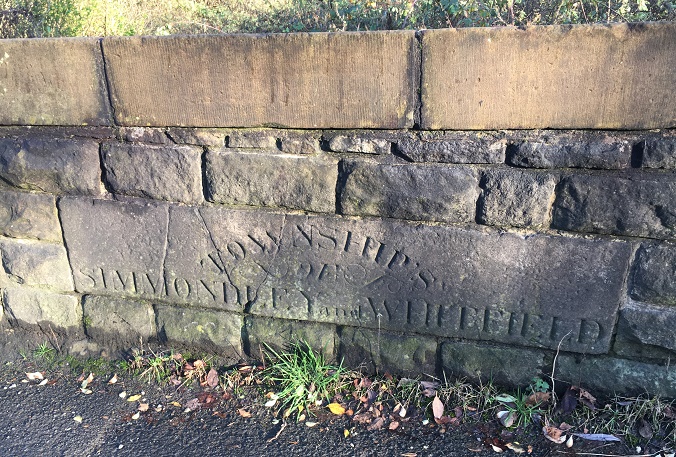
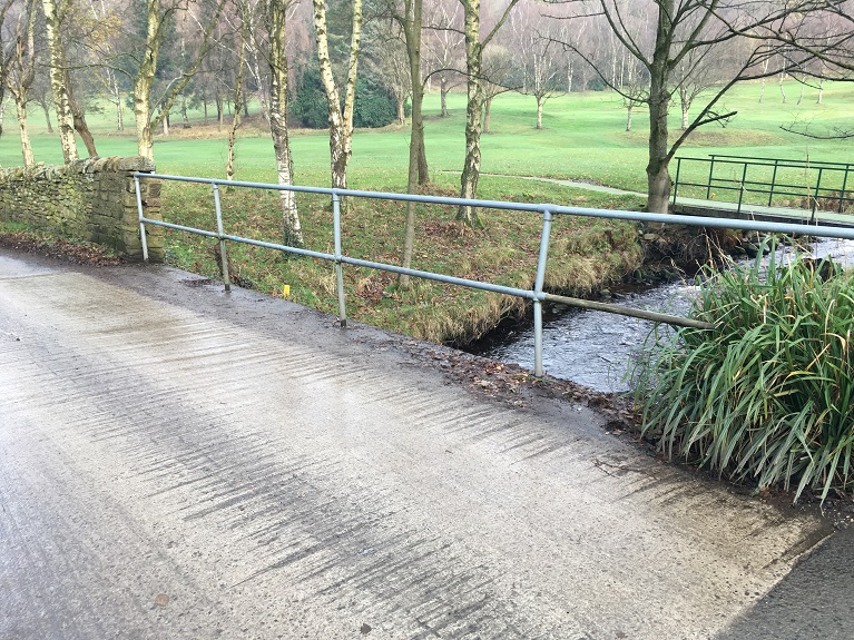
The next stone is to be found on Charlestown Road, on a bridge over Long Clough Brook – it’s very much a blink and you’ll miss it kind of affair, even if you are walking.
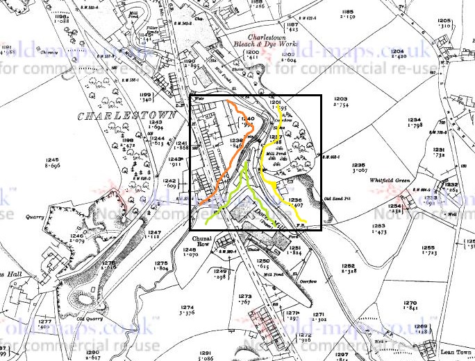
Turnlee and Charlestown Roads join at the top, with the boundary stone circled in orange.Here is the bridge over Long Clough Brook on Charlestown Road. The stone is visible.Here it is in close-up. Can you spot a mistake?
This stone follows the same formula as the Victoria Bridge stone, but is slightly rougher in execution. It seems to have been reset into a rebuilt stone wall at some stage, as it doesn’t really match the coarse surface of the stone around it, and this resetting might explain the cracking. It also has an inexcusable mistake… there’s a bloody apostrophe after ‘township’! It should read ‘TOWNSHIPS’, the plural of township, but instead it reads that ‘Township’ owns something called an ‘of Simmondley and Whitfield’! Also, although it states that this is the boundary between Simmondley and Whitfield, it technically isn’t. This is the border between Chunal and Simmondley, but it seems that for administrative purposes, Chunal and Whitfield were often lumped together. The confluence of Bray Clough (from Gnat Hole) and Long Clough Brook (just east of the boundary bridge) is actually the meeting of the three townships of Chunal, Simmondley, and Whitfield, here:
The three townships illustrated at the junction of Bray Clough Brook and Long Clough Brook. Chunal in green, Simmondley in red, and Whitfield in yellow.
So far, so good.
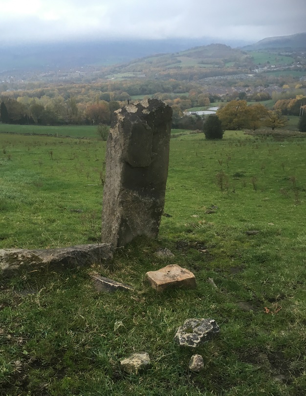
Now, the third and final stone was a bit more of a mystery. According to Neville Sharp (Glossop Remembered p.184 – a great book, by the way, well worth seeking out – here for example, but order it from Bay Tree Books on the High Street, of course), a stone similar to the one on Victoria Bridge stood on the bridge over Hurst Brook which forms the north eastern boundary between Glossop and Whitfield. That is until it was washed away in a flash flood.
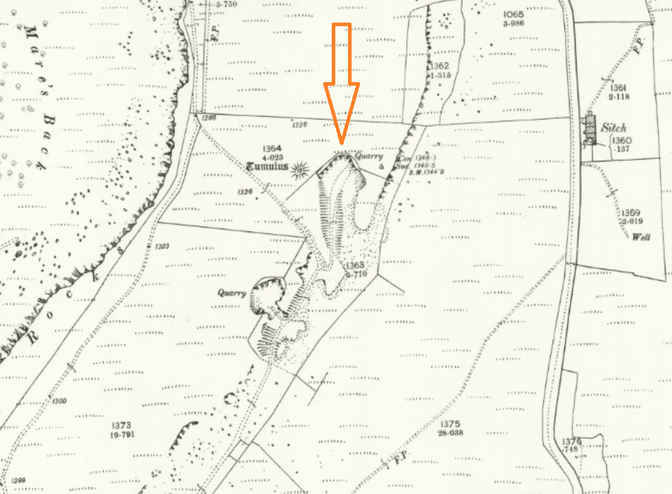
High Street East at the top, with Derbyshire Level running from the Royal Oak off the map at the bottom. The word stone on the bridge over Hurst Brook is circled.
Then, whilst doing some research, I came across a reference to the stone and made a note in my notebook that until at least 1977 the stone stood next to the entrance to Golf Course. Annoyingly, I didn’t take down the reference and it’s taken me 3 years to track down the source of the information. Three years! Such is the level of detail and dedication I devote to this blog in order that you, gentle reader, can revel in such a fascinating subject as “bits of old plate” as it was once described by the person who runs the ‘Official Glossop‘ twitter account. Honestly, the nerve of some people…
So I re-found the source – this website – and blow me if it didn’t have a link to photographs of the stone taken in 1977:
Entrance to the golf course on Derbyshire Level, the boundary stone bottom centre, in the glorious sunshine of the summer of 1977
Close up of the boundary stone with part of the word ‘Glossop’ visible. Please note that I don’t have the copyright to these photographs, and make no claim to such, they are merely ‘borrowed’ from the above site.
The stone was presumably recovered, in its broken state, and set up on the side of the Golf Club entrance, and whilst it doesn’t look like there is a lot left I went to have a look.
The same view as the first photograph above, missing the important piece.
Alas… the stone is no longer there. I had a good look around at all the stones that might be a possibility, but to no avail. I suspect that someone has taken it – it was a nice piece of stone after all, but it is a shame. All is not negative, though, and from the 1977 photograph we might suggest where it originally stood; the fact that the fragmentary word ‘Glossop’ is visible at the left hand end of the stone means that it could only have stood at the eastern side of the bridge, closest the golf course, for it to make geographic sense – Glossop is north, Whitfield is south at this point. Here, in fact:
Here. You can see the modern(ish) bridge that must have replaced the one that was washed away. Here, Hurst Brook separates Whitfield (right) from Glossop (left).
Its fragmentary nature also suggests that more of it lies in the stream bed – I had a look, but couldn’t see any likely stones, but perhaps next summer I’ll have a poke around.
Right ho, that’s all for this time. Hope you enjoyed a ramble around the boundaries, and in fact I am writing a blog post that actually covers the boundaries of medieval Glossopdale based on a 13th century perambulation. I’d also like to do another that looks at the boundaries of all 10 townships of Glossop as they are in the Domesday Book, which could be a bit of fun. ‘Could‘ being the operative word here. And ‘fun‘ being an entirely subjective concept, I realise. But you, kind and gentle people, know what I mean… after all, you’re reading this. Please drop me any thoughts or hints, even to point out my mistakes, or the fact that I need a haircut. Take care of yourselves and each other, have a very merry Christmas, and until next time, I remain.
So, apologies for the late running of this blog post. I have half a dozen half-written posts at any one time, and this one seems to have had a difficult birth! It was finally scrawled on the back of the minutes of the AGM for the Glossop & Longdendale Archaeological Society in a cafe whilst waiting for Mrs Hamnett to come out of surgery in Wythenshaw Hospital! (All is good on that front, and she is making a recovery). Apologies also for the length of this one, and for the archaeological theory. I do love a good bit of interpretation, and in my previous archaeological life this was the stuff that nourished!
I was having a conversation with my brother-in-law the other day (Hi Chris), and he asked whether I had seen the standing stone on Long Lane, between Charlesworth and Broadbottom Bridge. As it happens, I had, and it was on my ‘to do’ blog list.
And here it is, being done… well, we’ll get to it in a minute
Standing stones and stone circles are some of the things that first grabbed me when I began to look at archaeology seriously. The fact that they were a tangible and impressive representation of the past made them stand out, and yet they were enigmatic – their function and meaning still not fully understood. Single standing stones in particular have been overlooked as monuments; their very nature – a single stone, standing upright – has meant interpretation is difficult. Moreover, they are largely undatable unless associated with other monuments such a stone circle, and people throughout history have stood stones upright, and for a variety of reasons (cattle scratching post, waymarker, gatepost, etc.). Generally, though, they are considered to belong to the later Neolithic and Early Bronze Age (roughly 3000BC – 2000BC). As to their function, they are often viewed as marking a territory, or as a meeting place, usually with ‘ritual’ overtones. In more recent times, they are often associated with folklore and the supernatural, and even leylines.
A stone beside the River Etherow, in Broadbottom. This one is, I think, a glacial erratic.
Recent archaeological work has begun to unpick the possible meanings and functions of many of the monuments of prehistoric Britain, and especially those of the Neolithic. This has been done more subtly and intuitively than previously, and looks at monuments in their surroundings, and how the people would have experienced, used, and passed through them, rather than viewing them as just objects. Words like landscape and phenomenology are used, and it often draws on other disciplines such as philosophy to help with understanding the past. Extrapolating from this work at the larger monuments, and in particular the pits, causewayed enclosures, and chambered tombs of the Early Neolithic, we can use some of these ideas to explore a possible meaning of the standing stones of the Late Neolithic and Early Bronze Age.
As I’ve said before, a standing stone is just that, a stone, standing. But conceptually, it is much more than that, it is a fixed point in the landscape, around which human experience can revolve, and emerges from a concern with marking a particular space as being different from it surroundings, transforming it, and placing it within the landscape but apart.
It is clear that the actual creation of monuments such as these was just as important as the finished product, and the erection of a standing stone is not a simple task. It requires group work and cooperation; with the stone weighing perhaps a ton or more, families, extended families, kinship groups, or even clans would be working together to make the stone. It would be a period of community, sharing work and food, and the creation of joint place. The stone would have to be shifted and shaped, and here we have decision to be made. From where is the stone to be quarried? The source may be significant to the people creating the monument, and perhaps that quarry or stone type already figures in their stories and beliefs, already a sacred site. Although practical considerations are possible, it may not always be the case – the Stonehenge Bluestones were moved by land, sea, river, and land from the Preseli Hills in Wales – a journey of over 150 miles, because they were deemed important. Our practical concerns are different from theirs.
Then we must consider location, why was the stone sited where it was. The larger monuments, such as the enclosures of the Early Neolithic, often have evidence of earlier occupation, and it seems that the monuments are referencing these flint scatters and back-filled pits, a way of acknowledging those who went before – the ancestors. It may be the case with the standing stones. But equally, they may reference something else – a feature of the landscape, or perhaps some other, more numinous reason which we would never be able to fathom. Did a shaman have a vision suggesting the site? Or did lightning strike? Or someone die there? Or… you get the idea. And did the stones stand on a bare hillside as they do now, or did they lurk in a bright woodland clearing?
Another stone by the River Etherow. This one is shaped, and was perhaps a gatepost.
Once in place, the people responsible for erecting it might visit periodically – every year on midsummer’s eve, for example, or every full moon, or when the cattle are herded from lowland pasture to the upper areas, or even every day. But certainly through these periodic visits it would be seen as, calendar-like, marking time, or even creating a ‘mythic’ time, outside of ‘real’ time. They might have visited in large groups, taking the form of kin-related clan-wide celebrations, for example, or perhaps in small family groups, or even as individuals. Each visit would recall previous visits, previous times of coming together in celebration, or in mourning, for example. But there would be feasting and celebrating, certainly, with people gathered in their groups round hearths and fires.
Perhaps the area around the stone was kept spotlessly, meticulously, clean, and each visit revealed traces of the old hearths clearly, and the conversations, people, exchanges, jokes even, that happened around those hearths would be recalled and spoken about. And it’s not hard for us to imagine a group of people, framed by firelight, moving in a circular fashion around the stone, dancing. But perhaps, and I suspect more likely, the area around the stone was littered with the detritus of these older meetings – pottery, animal bone, flint, pits dug into the earth, stone, and other bits and pieces, all deliberately displayed as a reminder of the past visits. There may well have been human remains, too, in the form of cremation or as an internment, or even random bones, carefully kept and handled – curated for generations – before finally being deposited around the stone. Each item or object speaking to the people of the past, of past lives and events, and of the ancestors. With each visit, again and again, there was the creation of new memories, new meetings, and yet still the recollection of older ones – the ancestors would have loomed large and heavily in these times.
The stone here acts as a mnemonic device, an object that helps us remember. That is its purpose, its meaning… to help us recall previous visits to the stone. Using the stone as a focus in this way, time can be manipulated: the individual can visit past people and events, travelling and recalling; but equally the ancestors and past gatherings can be brought into the present through shared memory. Importantly, the ancestors can be projected forward into the future, asking for their intercession for a good harvest, for example, or for help and advice.
And of course, when the people gathered together for feasting and celebrating, there would have been exchanges in the form of gifts and barter – and from hearth to hearth, and valley to valley, there was an exchange of resources, news, gossip, alliances, ideas, beliefs, objects, allegiances, skills, animals, marriage partners, and so on.
In fact, all the drama of human existence revolving round this fixed point in the universe, a node, a single stone standing in not just a physical landscape, but in this case a cultural landscape, and on a personal level, a psychological landscape.
Phew!
So then, the stones…
Hargate Hill Stone
Let’s start with the stone that sits on the corner of Hargate Hill Lane and High Lane, the road between Simmondley and Charlesworth. It’s here:
The stone is circled. The air shaft to the right is the mine shaft down which Albert Burrows, the Simmondley Pit Murderer, pushed his four victims – the subject of a future blog post.
Here is the stone.
The standing stone above Hargate Hill. Mouselow Iron Age Hillfort is in the background.
The stone is very obviously deliberately placed, and sits on the junction of two tracks, both clearly ancient, and like many standing stones, it stands mid-slope, i.e. not at the top or bottom of the hill. It could be argued that the stone is placed as a marker for the tracks, but I suspect that the track from Hargate Hill used an already existing stone as a sight marker. Interestingly, Neville Sharp suggests that its chisel-like head points towards Shire Hill, some 3km north west of the stone. And yes, seemingly it does.
Shire Hill looms darkly through the murk.
This may be important. It is not uncommon for standing stones to reference features like this, and Shire Hill is fairly prominent in the landscape, even on gloomy days, it can be made out easily, as the above photograph shows. Interestingly, in the mid 1950’s, the cremated remains of a female dating to the Late Bronze Age was uncovered on the south slope of Shire Hill during the building of a bungalow there. The remains had been placed in an upturned burial vessel, which was laid on a bed of charcoal. Sadly, there is very little information available about this important find. Out of our period, but points to prehistoric activity on the site.
There is, marked on the 1887 OS map (see above) another stone just to the east of this one. I have looked but cannot find any remains of a stone, even a small one, and not even reused as part of a wall – whatever was there in 1887 is no longer there now, sadly. But it is worth mentioning that standing stones sometimes occur in pairs.
Hague Stone.
I found this one years ago – I did a ramble in search of this stone and Pymm’s Parlour Roman rock shelter on the banks of the River Etherow (the subject of a future blog). Finding it was not easy, as it now tucked away in a wooded area, and for some reason I didn’t take any decent photographs… not sure why.
Hague Stone marked in red, Pymm’s Parlour (here Prim’s), a Roman rock shelter, in green. 1898 1:2500 OS map
Here’s the stone.
The Hague Stone, dead centre, disguised as a tree. Apologies for the photograph.
It’s a fairly hefty stone, as you can see, and tucked away, though the 1898 OS map shows it as standing in open fields. I will get a better photograph this winter, I promise! Not a great deal to say about this stone, though I think it is important, as we’ll see.
Long Lane Stone
Very visible from Long Lane, this stone has long intrigued me.
The Long Lane Stone marked in red. Another stone is circled in green. 1887 1:2500 OS Map
I have been unable to get a decent photograph of the stone, as it stands in a field that grows turf for Lymefield Garden Centre, and one doesn’t like to trample on the new grass (and I don’t recommend you do either). Every other time I’ve tried, it’s been too dark, too bright, etc. So here is the Google maps version. I’ll keep trying, and replace when I can.
The Long Lane stone. Long Lane is behind the camera, and Charlesworth to the left.
It’s a fairly bog-standard standing stone, shaped and set into the ground in the middle of a field. The 1898 OS map shows it standing at the head of what it describes as an ‘Old Quarry’, something that the earlier maps don’t show. I can’t believe it’s a quarry… what would they be quarrying here? A marl pit perhaps, but not a quarry. Perhaps it is a feature associated with the stone? What I do find interesting is that the stone hasn’t been moved – either in the past, or more recently, in order to make harvesting the turf more easy. Folkloric associations with bad luck? Whatever the reason, it’s great that it remains
As with the Hargate Hill stone, on the 1887 OS map, there is another stone marked, south of the main one, further up the hill toward the church (in green on the map). I have not been able to investigate this as it now stands on very private property, behind a locked and alarmed gate. I have not been able to see anything on later maps or aerial photographs, and it may just be a small unrelated stone – the early OS surveyors marked anything that couldn’t be moved on their maps. I would still like to investigate though, so if anyone knows anyone or anything, please let me know.
Now, these last two stones, for me, are particularly interesting. Let’s play a game of ‘what if’ Assuming that the stones existed at the same time, they would have been intervisible – you could see one from the other. They stand on opposite sides of the river, and on opposing hillsides, but are at about the same elevation, and both middle hill, not at the top. In a sense they are facing each other, and we may understand them perhaps as rivals, representing two different nodal points, perhaps for two different clans. But what if, instead, they are viewed as complementary? What if we take them together, as a pair, making a statement? The location of the Hague stone is at the head of the valley, just past the Besthill Bridge and the cliffs of Cat’s Tor there. The cliffs are steep and difficult, and logically the slope where the stone is located is the first patch of land that would allow it to be dug in. I feel almost certain that the stone references this point, and that it is placed at the head of the Longdendale Valley.
The view from just about where the Hague stone is. The Long Lane stone is far to the right, the Longdendale Valley is opening out ahead, and the Iron Age Hill Fort at Mouselow is middle right.
If we accept that the Long Lane stone references the Hague stone, then we seem to have a pair of distant, yet connected, stones standing at the head of the Longdendale Valley – gateposts of a sort allowing you access into the valley, and which form a part of a larger landscape, shaped and controlled by the people in prehistory. This puts a very different spin on the place, and suggests all sorts of areas for further research.
Of course, it is all ‘what ifs’ – a story if you will, and one that is completely unprovable. But it is possible, and I genuinely believe that the Hague stone at least is there for that purpose; you often find stone circles situated at the confluence or head of valleys, so why not a single (or pair of) stone(s)? Something to think about, if nothing else.
If you are interested in the ideas about British prehistory that I have been talking about, there are a number of very good books on this subject. I would recommend starting with:
Britain BC by Francis Pryor An excellent and easily read overview of prehistoric Britain. Really very good.
Stonehenge by Mike Parker Pearson A compelling & easily read account of the Stonehenge Riverside Project, and in particular it covers Parker Pearson’s theory that stone = death, and wood = life.
Ancestral Geographies of the Neolithic by Mark Edmonds Academic, but a good and accessible read. Full of wonders. Highly recommended.
These next are academic archaeological books that are a bit more complicated, and require some background knowledge.
Understanding the Neolithic by Julian Thomas Essential reading, but very dense. Not recommended for the casual reader.
The Significance of Monuments by Richard Bradley. Another good one, dense in places
Ritual and Domestic Life in Prehistoric Europe by Richard Bradley. Again, really good, and quite accessible. It covers the whole of Europe.
As always, any comments, questions or corrections are welcome, just drop me a line – either email in ‘contact’ above, or in the comments section below. Next time I’ll blog about some interesting pottery… I think.
After my last post on milestones, I received a message from the always interesting Roger Hargreaves (see comments below the above article). Now, Roger is something of an expert in these matters, and has done some considerable research into the road system of the area through the ages – Roman to 19th Century in fact – and he helpfully offered some information, and some photographs, too.
So then, the milestones…
Following an act of parliament in 1770, the milestones were erected every mile (hence the name) along the 1730’s turnpike from Manchester to Saltersbrook by the surveyor James Brown jr. Later sections of turnpike were built from Saltersbrook to t’other side o’ Pennines – there’s a great website, with lots of pictures, dealing with that section, here. This road from Roe Cross follows broadly the route of what is now A628 / Woodhead Pass, itself a turnpike from the early 19th Century, and which overlays the original road.
However, in places, this 1730 turnpike is still visible where the 19th Century road deviates, perhaps taking an easier route, and so sections can be walked, and it is along these that milestones, where they survive, can be seen.
Here is a section of the original 1730’s turnpike. It leaves the Woodhead pass at the first circle, and rejoins past Crowden, at the second circle.
The 1730’s turnpike as seen on Google Streetview. The road originally went up to the left – you can see the path, and can walk along it for a large portion.
Now, because milestones are placed exactly one mile from each other, it is possible to work out where they should be. Of course, in some places where we would expect to find them, however, the newer road has obliterated all traces of the older road, and presumably the milestones would have been broken up and used as hardcore, although not necessarily, and it might be worth a further investigation – they are perfect for gateposts, after all.
So, starting from Roe Cross, then
10 Miles from Manchester – this would have stood at the Toll House at Roe Cross
11 Miles (somewhere on Mottram Moor) and 12 Miles (far side of Hollingworth) are missing – the area has been built up, although they may well still be in a hedgeback somewhere.
13 Miles to Manchester – this would have originally stood somewhere in Tintwistle – annoyingly, the mileage doesn’t work with it being situated at the toll gate there, which stood at the far end of the village, west of Townhead Farm.
14 miles is missing, but would presumably have stood east of Townhead Farm – again, worth a look in hedgebacks and walls.
15 Miles to Manchester. Just by Rhodeswood Reservoir. Photograph by Roger Hargreaves. And a damn fine one it is too!
16 Miles would be just below Highstones, where the track still exists, and so would be a strong contender for a survival in the walls and hedgebacks.
17 Miles and 18 Miles are in places where the 19th Century road overlies the 18th Century, and thus are likely to be lost. Although, again, maybe worth a look.
19 Miles to Manchester – mutilated and forlorn in a wall at Higher Wooodhead. Photograph by Roger Hargreaves. I love this photograph.
20 and 21 Miles to Manchester are beyond this, and although there is a survival of the road in these areas, there are no walls in which the stones may be hiding. It is likely that they are simply buried in the peat in that area, waiting to be discovered. A walking trip with a steel pole, anyone?
This takes us to Saltersbrook, and the other side of the turnpike system there. Here is a map of the road from Saltersford into Yorkshire.
The Yorkshire side of the turnpike road, from Saltersford to Wortley. There are plenty of milestones and other interesting goodies along this route, but they are truly beyond the scope of this blog. Check them out in this really amazing website.
So after the journey, let’s end on a song – a particular favourite of mine, from a particularly good album, and whose title is very apt.
I also want to thank Roger Hargreaves for allowing me to use his photographs, and for the additional information.
As always, comments or questions are always welcome.
So, a while back I went looking for the White Stone of Roe Cross… and failed miserably in my mission.
As I said here, it is mentioned in Sharpe’s book “Crosses of the Peak District” as potentially marking the junction of the boundaries of Matley, Hollingworth, and Mottram, so I thought it would be worth a look, and maybe make a comment on what, where, and why.
I did some digging (pun fully intended), and came up with very little; it has almost zero presence online (other than this letter), and other than a modern book (about more, later), virtually nothing but an oblique reference. I began to despair… until I started to dig a little further – my ‘spidey sense’ began to tingle. Summat wants fettling, thought I.
What I did come across time and again was a reference to the legend of Sir Ralph de Staley, and his relation to Roe Cross, and the Roe Cross. Now, the story of Sir Ralph de Staley (Staveley or Stavelegh or Staveleigh – there are numerous spellings), is a variant of “The Disguised Knight”, a story trope that can be traced back to at least Homer’s ‘Odyssey’. Our story, culled from several sources, runs like this.
With Richard I, Sir Ralph sets sail on a crusade leaving behind his wife, Elizabeth, and estate. By and by, and following many great battles, he is captured by the Saracens, and held for many years in a dungeon. Eventually, he gains his freedom, takes on the appearance of a Palmer (a pilgrim), and pays a visit to the pilgrimage sites in the Holy Land. One night, in Jerusalem, he had a prophetic dream “boding ill to his wife and home far away”, and so, invoking the intercession of the Virgin, he prayed and presently fell asleep.
Upon awakening, he immediately knew something was different – “before him, shining fair in the summer sunlight, rich in fulsome melody of singing birds, was a fair English landscape, and beyond it his own ancestral hall of Staley”. He had been miraculously transported home.
He set off for his house, and came upon a faithful old servant and his favourite dog, who presently recognised him. He told Sir Ralph that his wife, who had finally given up all hope and now believed him dead, was to be married the following day. So off he jogs to his hall, and asks to see the lady of the house. He is refused, but begs a drink of Methyglin (a type of spiced mead, apparently), and after draining the cup, pops his ring into it, and begs the maid to take it to her lady. She does, his wife recognises the ring as belonging to her husband, and asks an important question “if it be Sir Ralph himself, he will know of a certain mole on me, which is known to none but to him” (racy stuff, this). Of course, all ends well and happily, and the bounder that is trying to get Sir Ralph’s lands and his missus, is ejected rapidly into the night. And quite right, too.
So ends the story.
The 15th Century timber-framed Staley Hall before being done up. That is truly one of the most depressing photographs I have ever seen. How we can let our history end up in this state…
That’s better, although the wall at the front is a little off putting. The restoration work here is particularly good.
Now, here’s where it gets interesting. As a post script, most versions of the story (there are about 5, each with subtly different aspects) state that a cross was erected either where Sir Ralph meets the servant and dog, or where he wakes up following his miraculous movement. This is the Roe Cross – Ro, or Roe, apparently, being a shortened version of Ralph. Indeed, several sources mention a cross standing on the old road from Stalybridge to Mottram. But where is the cross? There is certainly not one there now, nor is there any evidence attesting to one. There is, however, the White Stone.
Ok, so here is what I think happened.
I don’t think there ever was a cross, not as such. None of the sources I consulted actually describes a cross, only that one was there (as told by the story and indicated by the name), or that there are the “remains of an ancient cross” on the road there (and thus presumably referring to the White Stone). It seems that the White Stone and the Roe Cross have become intertwined. Ralph Bernard Robinson, in his book ‘Longdendale: Historical and Descriptive Sketches‘ (1863) illustrates this perfectly by noting the existence of both cross and stone as separate monuments, but he only describes the stone, not the cross. I would argue that it doesn’t/didn’t exist.
It is most likely the name Roe Cross is derived from ‘roads cross’; the area is, after all, the junction of seven roads – Harrop Edge Road, Matley Lane, Gallowsclough Road, Mottram Road (Old Road), Hobson Moor Road and Dewsnap Lane. Indeed, according to Dodgson’s Place Names of Cheshire (Vol.1, p.315), there seems to be no reference to Roe Cross prior to 1785 (although this may turn out to be incorrect, with further research).
Roads Cross = Roe Cross. You can see the coming together of all seven ancient tracks, converging on Roe Cross. Ignore the 18th Century Turnpike at the bottom.
So far, so good… now bear with me. The White Stone is a marker stone, marking tracks over the tops, and/or marking the boundaries of Matley, Stalybridge, and Hollingworth, and it has been there from the year dot. As a feature in the landscape, it was given a story, as all such features are – they accumulate stories, because people have an intrinsic need to have a relationship with their environment – and it takes on a personality, and gains a biography. As the archaeologist Richard Bradley says of monuments “they dominate the landscape of later generations so completely, that they impose themselves on their consciousness”. The story of Sir Ralph (whether ‘true’ or not) was given as a way of explaining both name – Roe Cross – and reason for the existence of the marker stone. In fact, in Ralph Bernard Robinson’s account of the legend, Sir Ralph wakes up “beside a large stone”, and later on notes that “tradition points out the stone under which he found himself laid: and a queer old stone it is.” Clearly he is describing this from his own personal experience, and surely there can be only one stone that is worth pointing out in the Roe Cross area… it has to be The White Stone.
As a postscript to the postscript, Sir Ralph and his wife, Lady Elizabeth Stayley, are supposedly buried in St Michael and All Angel’s church, Mottram. There are two 15th Century carved effigies that are to be found in the Stayley Chapel there, which almost certainly are meant to represent the good knight and his wife, and which were originally placed against the south wall of the chapel. As Aikin in his ‘Description of the Country Thirty to Forty Miles Round Manchester’ (1795) notes, “many fabulous stories concerning them are handed down by tradition among the inhabitants”.
This from Aikin’s Description of the Country Thirty to Forty Miles Round Manchester’
Sir Ralph and Lady Elizabeth de Staley. This taken from the official guide to Mottram Church here.
So then, the White Stone. Well, I still haven’t found it! But I do know a bit more about it, and now – drum roll please – I have a photograph of the bloody thing, stolen shamelessly from Keith Warrender’s book ‘Manchester Oddities‘. I heartily recommend this book, as it’s chock full of just the sort of odd bits of history that this blog looks at. Buy it here. Or better yet, order and buy it from Bay Tree Books – buy local and keep independent shops afloat.
So here is the offending stone, in whose shade, Sir Ralph found himself transported from the holy land.
The White Stone of Roe Cross – it is indeed a “queer old stone”.
The reason for it being white is presumably to make it stand out, to ensure this important stone (boundary marker, track marker, or teleportation stone) is kept vividly different from any other in the area. Apparently it’s now on private property, which would explain why I couldn’t find it last time I went looking for it. I’m not sure of its exact location, but somewhere in the vicinity of White Stone Cottage would seem to make sense. Here is the drawing in Sharpe’s ‘Crosses of the Peak District‘.
Not very cross base shaped, but then I haven’t seen it close up. Yet.
I love it when a legend has a physical mark in the landscape, it makes it more real, and as I say, it is a natural instinct in humans to build stories around their places. I recently led a guided archaeological tour of Alderley Edge, which looked at the Legend of the Wizard through an archaeological lens, and this same element, on a smaller scale, was at play here. Place and story working together, informing and shaping each other.
Apologies for the slightly rambling nature of this blog post, but I hope you enjoyed it.
As always, comments and questions are most welcome.