So, I received a pair of emails recently, and both of them answered an outstanding question that has been bugging me for some time.
Answers people, we actually have answers! I asked, you listened, and by Great Zeus (or Arnomecta, perhaps) you answered.
So, drum roll please…
THE STONE IN ST JAMES’S CHURCHYARD, WHITFIELD.
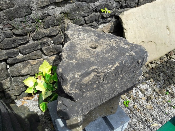
I mused here on the possibility that a large, out of place, stone in the churchyard St James’s, Whitfield, might be part of the base of the Hollin Cross that almost certainly stood at the junction there, on Hollincross Lane.
Here is the stone in St James’s – not a cross base!
I was wrong. And how!
I got an email from Louise Seville which states:
“My father-in-law Neal Seville had some connection with the church (Sunday school??), I think in the 1970s. He was giving a talk based on the parable of the wise man and the foolish man. He and his friend Bert Taylor from Chunal, brought the stone from Bert’s own small quarry at the back of his house on Chunal. The stone was moved on a truck – Bert had a haulage company. The stone was used in church to illustrate the story and was abandoned in the churchyard afterwards as it proved to be too difficult to move. Neal said that in the future people would wonder how the stone got there and come to all sorts of conclusions! “
And how right he was!
So there we have it folks. I genuinely think that it was bonkers to use a stone that size to illustrate the parable, no matter how factually correct! But apparently that was about right for Neal, who got up to all sorts of capers. Here is the parable, for those of you that slept through Sunday School.
So my thanks to Louise and Eddie Seville for solving the mystery. And, of course, thanks to the late Neal Seville for providing one in the first place.
Now, the next one has bugged me for years, so I am truly grateful for its solution.
THE ODDLY SHAPED CERAMIC OBJECTS
I asked for ideas about these bits of pottery that Sandra T. and I had found. They were so oddly shaped, and so similar in production, that they must have had a single, very specialised, purpose. But what purpose, that was the question.
The puzzling pieces of pottery
Well, bam! An email from the wonderful Eddie Picton arrived in my inbox the other day.
May I suggest that they are “creel peg pivots” as used in textile machinery. A roving bobbin had sliver wound on it, this was then put upon a creel peg and then put in following machine creel. The lower end then would be free to rotate on the ceramic with minimal friction. I worked in the last spinning mill in Oldham, the last of this type of creel was scrapped in the early 1990s, the mill finally closing 2002.
The connection between the object and the place – both connected with weaving and spinning – made this very likely, and it is not an interpretation I had thought of before. I did a bit of research, and began to understand how they would have worked. Yes, it seemed to fit.
Last night, Eddie was at the Glossop and Longdendale Archaeological Society talk on ‘Melandra – Past and Future’ given by Mike Brown and Roger Hargreaves (and very good it was too). He gave me this drawing of how the creel peg pivot would have worked and where it sat in the machine.
Great drawing Eddie, thanks.
Our pottery pieces are those marked ‘Pot’ in the picture, with the bobbin/creel peg sitting in the hollow, glazed, part of the mystery object. They are tapered slightly so that they can fit into the holes in the frame.
These are those, in situ, in Styal Mill. The photo is Eddie’s.
So that’s that solved! Thanks for that, Eddie, you’re a star. And it seems I owe you a drink… I’m as good as my word. See you on the first Tuesday of November.
I have another blog almost ready to go, so fingers crossed you’ll get a bumper crop of posts by the weekend.
As always, comments and questions are very welcome.
What ho, what ho, what ho! So, I’m back from my summer holiday. Actually, I was only in France for two weeks (with lots of cheese and wine), and the rest of the time I have been busy with life… alas. I have loved the weather here for the last 10 weeks – a decent summer at long last, and the polar opposite of the spring we had. Bizarre.
So, missing out August completely, I’m back with a bang, and hopefully more than one post over the weekend, here we go.
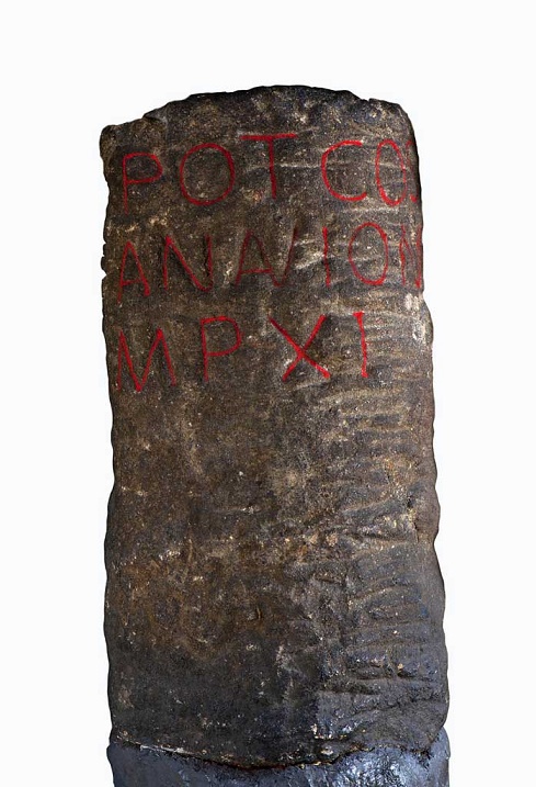
I love milestones. There is something so definite and so grounding about them, and the way in which they locate with reference to other places – you are X miles from Y – you know exactly where you are in the world. They have a long history – the Romans used them all the time, and in reality, they haven’t changed since. This one was found in Buxton, and is inscribed with the following: “TRIB POT COS II P P A NAVIONE M P XI”.
Buxton Roman Milestone, found in 1862 (and shamelessly stolen by me from the wonderful ‘Wonders of the Peak‘ website). Honestly, it is well worth taking the time to look around the site.
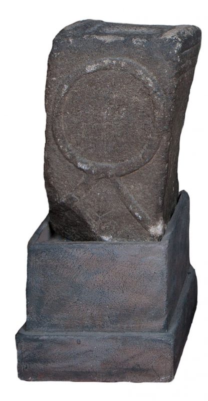
Which translates as “With tribunician power, twice consul, father of this country, from Navio, 11 miles”. The Roman fort of Navio is at Brough, near Castleton (information here). This is a great little fortlet, right on the river there, and well worth a trip out to see it. There’s not a great deal to see as such – rather like Melandra, it is lumps on the ground, requiring a bit of imagination – but it produced some fascinating archaeology. My favourite being an altar to the goddess Arnomecta – a local goddess, about whom we know nothing at all. She may be the same as the Goddess Arnemetiae who gave her name to Roman Buxton – Aquae Arnemetiae, but then again possibly not. Something about that both fascinates and frightens me – a lost Goddess.
Altar dedicated to Arnomecta – stolen again from the wonderful Wonders of the Peak website (use the link in the text above it for more information on the stone).
But I digress… where were we?
Milestones. Mine are nothing like as old, but they are interesting. Honest.
The first is located on the Woodhead Road/B6105 by Allmans Heath Farm and B&B. It is carved into the side of a mounting block, used for getting onto horses, is/was painted white, and it simply states ‘Glossop 1 mile’ with an arrow pointing the direction.
The milestone is at the bottom, carved into a niche. The ring on the block would have held your horse in place whilst you climbed aboard.Close up of the milestone: “Glossop 1 Mile”
Now, the mounting block is clearly old. They don’t make them anymore, for one, and the fact that the ring has been set in place using lead would certainly age it to the Victorian period, and potentially earlier. The carving is another matter altogether. I had assumed that the words would have been carved in the Victorian period, but on the way to take the photograph, I got speaking to the owner of the house there who informed me that they were only 10 years or so old – her ex-husband, being a stonemason, carved them. Well, why not? The fact that the mounting block sits next to a very old stone gatepost (on the right in the upper picture) suggests that the owners had moved the stone to the front wall in order to create a feature, which it does.
So, this one might not be of any great age, but the next two certainly are, even if they are slightly out of the area.
I went looking for the fabled White Stone of Roe Cross the other day.
I say fabled as there is very little information about it, and I was hoping to see it to put in my two penn’orth about what it is, why it is, and where it is. It is mentioned in Sharpe’s “Crosses of the Peak District” as potentially marking the junction of the boundaries of Matley, Hollingworth, and Mottram, so I thought it would be worth a look. Alas, I failed utterly to locate it, although I did get as near as White Stone Cottage, so I could’t be too far away. It has almost no presence online, either, besides a letter that was written to protest against the proposed Mottram bypass which mentions it in passing, and references to White Stone Cottage.
If anyone knows the location of the stone, please let me know, as I’d love to see it – and you all know how much I love a good stone.
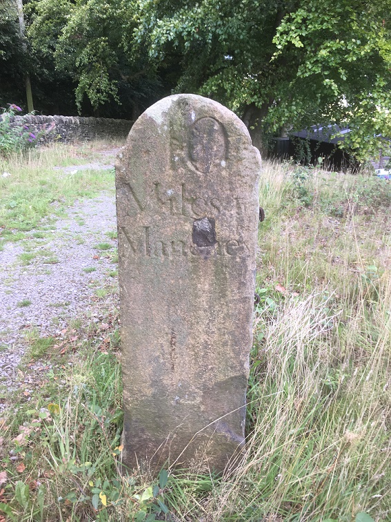
Now, that same letter, also mentions a carved milestone in that area, and thinking it might be worth a look, young Master Hamnett and I set off down Dewsnap Lane to find it. Which we did in record time – standing alone in a right hand turn into the riding stables there (the location is shown by the red circle on the map below).
The Lonely Milestone
The stone states it is “10 Miles From Manchester” and I have no reason to doubt that. It has clearly been used as a gatepost at some stage, and you can see the hole where the hinge was mounted.
Close up of the writing and hinge hole.
As I turned around to leave the stables area I noticed another milestone, this one placed against the wall.
Another milestone
This one proclaimed itself to be ’13 Miles From Manchester’.
“Hmmmmm”, thought I. “Ice cream” thought Master Hamnett.
Close up of the carving.
Now, I know what you are thinking… that Roe Cross is a geographical anomaly, being simultaneously both 10 and 13 miles from Manchester; a quantum place, if you will.
The two stones are obviously carved by the same hand and at the same time – the rounded top and squared shoulders are the same in both instances, and the stone is the same – a coarse sandstone. The writing is also the same, and with the ‘long S‘ in the word ‘Manchester’, we can roughly date it to not later than the first half of the 19th Century, and possibly a little before. After this time it falls out of use, and people used the ‘short S’.
So what are they doing there? I don’t know for certain, but I have a possible/probable answer.
The ‘Deep Cutting’ between Mottram and Matley/Roe Cross was opened in 1826 as part of the Manchester to Saltersford turnpike road. Essentially, it allowed easy access between Yorkshire and the east of the country, and Manchester and the west. Prior to this, the roads were in a terrible state of repair, and the heavily laden packhorses that made that journey really had to struggle. The turnpike roads were privately financed and built, and in order to recoup costs they operated as toll roads, charging for their use (think M6 Toll road for a modern comparison).
The toll gate at Roe Cross, the place you had to pay for passage, was situated here:
The Roe Cross Toll Gate is marked on the map (indicated by the arrow). The circle shows where the milestones are now situated. This from the 1875 1:2,500 OS map.
Now, obviously, the milestones are not in their original location, and I would like to suggest that they were originally situated near to, or at, the toll gate, showing the distance to Manchester along the road. However, if that was the case, then why the difference in distance? Well, perhaps the ’10 Mile’ sign was put next to the new road, whilst the ’13 Mile’ sign was by the original, old, road. With both signs showing, most people would want to shave 3 miles off their journey, and travel along a new well surfaced road, rather than along a muddy track, pitted with animal and cart ruts – after all look how many people use the M6 Toll Road. The tentative date of the stones, too, fits with the construction of the road – the first quarter of 19th Century.
Of course, once the toll gate ceased to exist, the stones lost their usefulness, and particularly once new, more clear, signs began to be used on the roads. However, instead of being broken up, their size and shape is perfect for a gatepost, and so they were hauled a few hundred yards up the hill and given a new function.
Well worth a look of you get chance, and there is lots of good walking to be had up there. I am going to have good explore myself sometime soon, particularly up Gallowsclough, which, as a placename, can have only one meaning – ‘the valley where they hanged people’. Blimey!
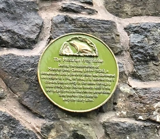
Incidentally, I love the Deep Cutting for the Mottram Frog Stone which is celebrated on the wall there, about half way down on the right (going from Mottram to Stalybridge). I couldn’t do this post and not mention it – I tweeted about it, but it is so good, that it needs to be celebrated on the blog, too.
The truth or plausibility of the story is much less important than the legend – no one criticises a fiction story for not being real, one just enjoys it!The stone itself, marked with a green frog.
There may be more this weekend, if I can manage it, but I will try to get back to my one a week post target, so stick around. Thanks for reading, and please, as always, comments and corrections are always welcome.
So, once again, I am forced to apologise for the lack of activity here of late – I expressly didn’t want the blog to be like the diary you start on New Year’s Day, full of good intentions, only for the next entry to be Auntie Mabel’s birthday sometime in July. The same can be said for those of you who I have not yet replied to their emails. So by way of an apology to you all, have a series of posts, starting with this one on the Guide Stoop.
Following on from the revelation here that one of the destinations on the stoop is probably Hayfield, I came across another example of a triangular guide stoop – this one is in the care of Saddleworth Museum and is kept in their outside/garden area.
The triangular guide stoop at Saddleworth Museum, similar in shape and style to our own.
It originally stood where the Standedge Road meets the A62 Huddersfield Road, and shows 6 destinations, two on each face, including Oldham, Manchester, and Huddersfield. Here’s how it would have originally looked:
From Huddersfield Highways Down The Ages by W.B. Crump
So this is similar to how the Glossop guide stoop would have looked… which got me thinking! If its original location was the top of Whitfield Cross, I wonder if the stoop would once have stood on top of the cross shaft. I find it unlikely that the guide stoop makers and installers would have made a new shaft if there was one standing in the right place already. Especially, as we must remember, by this time (early 18th Century) it had already lost its cross head, and due to puritan and Methodist views of the local people, would have lost all of its symbolism as a ‘Christian’ thing. In fact, so much so had it fallen from grace, that less than 100 years later it would be nicked and moved as a prank. So why not bung it on top of this convenient shaft?
Now, there is no evidence for this, and certainly there is no indication that anything was fixed to the remaining portion of the shaft as it is now, but we don’t know what was removed, or has worn away in its intervening 200 years standing as a stile. Just a thought.
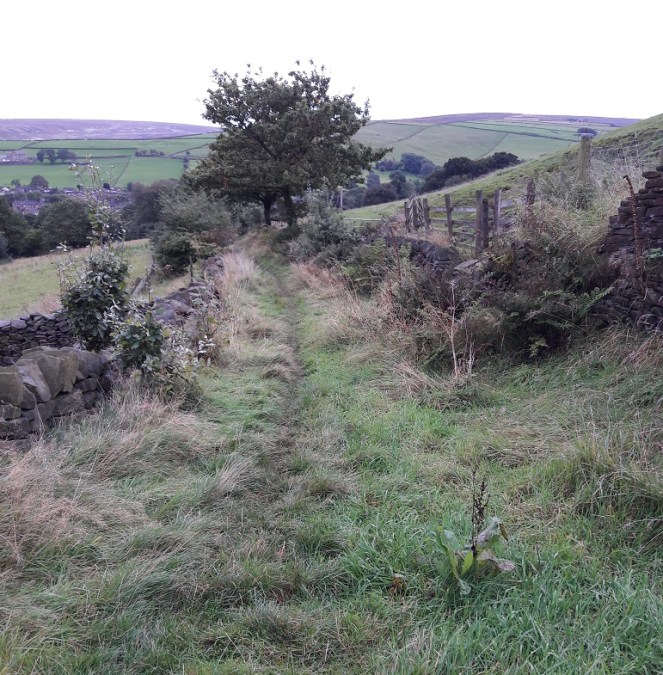
James and I went for a bit of ramble, up the hill and along Carr House Lane. Despite it being a very short distance from my house, it still took the best part of an hour… toddler speed is, I think I have mentioned before, glacial. So as I was waiting for the passing of an ice age, and hoping the clouds would stay away (they did), I began to think whether it would be worthwhile to have another poke around at the guide stoop to see if I might be able to dislodge some more stones.
It was. And I did.
I felt the last letter – a lowercase ‘l’… I think. Hang on, no. Is that something attached to it? an ‘e’? Ok, what next… Another ‘l’? … LEL?
I scrabbled around and moved more stones, all the while hoping the whole lot wouldn’t shift and trap my hand; nobody wants to be the guy on ‘Casualty‘ at whom the entire audience is yelling “Don’t be a moron, take your hand out of the wall *crash* See! Well you deserved that, idiot!”.
I could feel more letters, but I just couldn’t decipher them.
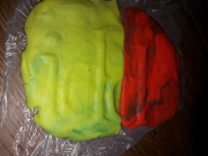
Then a series of thoughts… take a cast. James. Playdo!
So yes, 2 hours later, and armed with a two tubs of Playdo and a sheet of thin plastic, I returned, ready to make a ‘plaster’ cast of what I couldn’t see. I have to say, it was surprisingly effective! It took a lot of furtling and fettling, but I got about as much as I could. Enough at least. So then…
Excuse the dayglow colours… blame James not me. The photo is reversed, so that it reads correctly, the original is back-to-front.
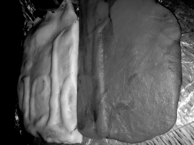
What do we have?
“…field“
It is a little hazy here, so I turned it to Black and White, and played around with contrast, etc. Anyway, here is the other version – between them, I think you can see the word “…field“. I hope!
It works better in Black and White from this angle. I tried taking a photo of the wall interior, but my phone ran out of battery. To be honest, I’m not sure it would have worked anyway.
So then, the placename ends in “…field“. So not ‘Chapel (en le Frith)’, or ‘Chunal‘.
So where then? And therein lies the problem! There are multiple places that fit the bill. If we assume that it is in the opposite direction from Glossop, and that it originally stood at the top of Whitfield Cross (see here for discussion), then it could be Moorfield, Hayfield, or even Macclesfield. If it stood somewhere other than the top of Whitfield Cross, then we might have to consider Hadfield or Padfield. Sheffield? Or even Whitfield… the stone may have travelled far and wide.
I have solved one problem – it ain’t Chapel or Chunal, but replaced it with another – which ‘…field‘ is it? My own feeling is Hayfield, but that’s based on nothing in particular, just reasoning.
No, the stone needs to come out of the wall!
And please, please, give me your comments and thoughts – I genuinely want to know what you think… because I have no idea!
I’d also like to say hello and apologise to the two people who saw me fettling in the wall and came to enquire if I was “alright” (i.e. not some sort of pervert sneaking around the back of peoples houses, nor a murder victim dumped in the bushes”). Thanks, and see… honest, I was telling the truth, I am an archaeologist. It was nice to meet you both!
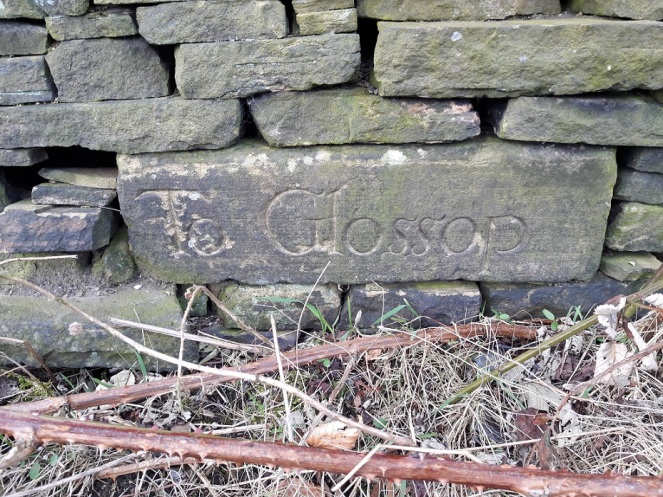
James, Mrs Hamnett, and myself went for a walk yesterday, taking advantage of the beautiful weather in the afternoon. Not a long hike – 2 year olds really don’t have a lot of stamina, and walk at a glacial pace, stopping to inspect stones, sticks, grass, puddles, clouds, etc. As we passed down the start of Carr House Lane, I looked to the left to see if I could see the guide stoop that I had been looking for since I first read ‘Glossop Remembered‘ by Neville Sharpe (highly recommended, by the way). A guide stoop is an early form of carved stone signpost, situated at road junctions, that tells you where each road goes; to use them, simply face the name of the location you want, and take the road to the right. They became common in the late 17th Century after a 1697 act of parliament, intended to improve road conditions, suggested that guide stoops were erected at junctions (There is a brilliant website about Derbyshire guide stoops here). In the book, there is a photo of a flat stone with the words ‘To Glossop’ inscribed rather ornately on the facing side. Stylistically, the date of the carving would be, I would suggest, sometime in the early 18th century.
Now, despite Sharpe telling us where it is, I have so far been unable to find it, despite trying dozens of times and in different seasons. I had begun to think that either it was firmly and permanently buried behind thick bramble and dog rose, or worse, that it had been removed and was now lost to us forever.
That is, until yesterday! Someone had attacked the bramble with secateurs, and lo and behold – the guide stoop was there!
On the left hand side, just as you enter Carr House Lane from Cliffe Road. Originally, it would have stood on a stone plinth.
This was great news as it meant that we might have a chance to work out what the other three sides say, and thus where it was originally placed. There was some debate about location elsewhere on this site (in the comments, at the bottom here), but I was excited to be able to try and solve the problem. In short, we have a 4-sided guide stoop, with ‘To Glossop’ on one side, and, according to Sharpe, ‘To Dinting’ on another. It’s possible that Dinting is on the opposite side, but there is nowhere near that Dinting is in the opposite direction to Glossop. Plus, if we place Dinting somewhere else on the four sides, where are the other two locations mentioned? Chapel (en le Frith)? Sheffield? No, it is a bit of a mystery… until now!
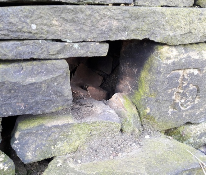
I felt along the right hand side, and with my fingers I traced an upper case ‘T’. Obviously, the start of ‘To’, but without dismantling the wall, there is no way of knowing to where. Tentatively, I removed some loose stones on the left hand side, hoping to push my hand in and be able to find the last letters of whatever place was written on that side of the square… and was shocked. It went back squarely for a few inches, and then turned abrubtly at 45 degrees. the stone was a triangle! Only three sides, and only three locations. I scrabbled my fingers along and traced a lower case ‘L’, but no more… The stone was too jammed in, and I couldn’t wriggle past it.
You can see the side turning 45 degrees to form a right-angled triangle.
I might try again at a later date, but in any case, I think we now have enough to hazard a guess as to where the places are, and to where it was originally placed.
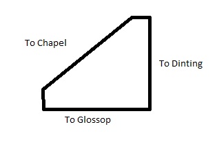
Glossop is obvious. Dinting is likely – we have no reason to doubt Sharpe, although I don’t know how he knew that. The last… well, we know it ends in an ‘L’, so it is probably Chapel (en le Frith) – although Mrs Hamnett suggests, not unreasonably, Chunal.
This is my reconstruction of the guide stoop’s inscriptions and shape.
A right-angled triangle, in this configuration. Probably!
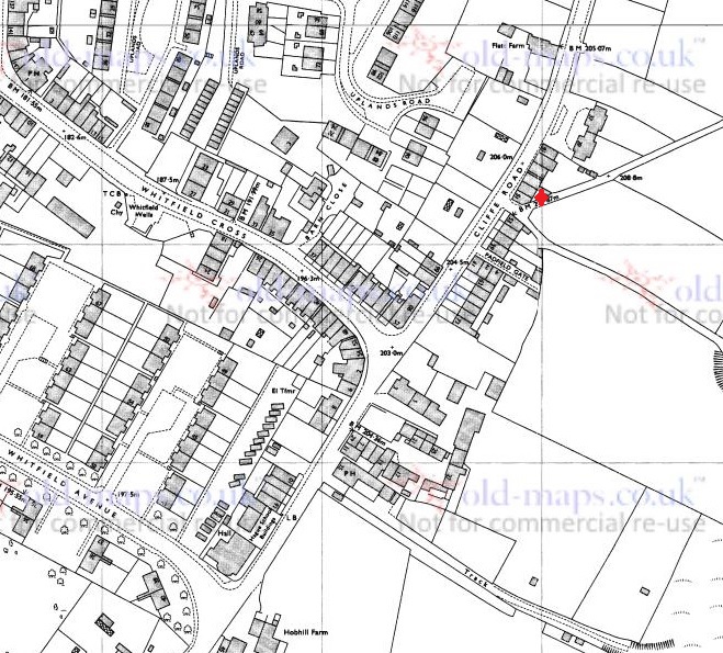
So where, if this is the configuration, did it stand? Well, simply and almost certainly, at the top end of Whitfield Cross, where it meets Hague Street/Cliffe Road.
The three-way junction at the top of Whitfield Cross works perfectly in the above configuration. Incidentally, the red blob marks the location of the guide stoop, on the left hand side going up Carr House Lane.
If this is the case, the ‘Glossop’ side would be facing south east, indicating Glossop is down Cliffe Road. Dinting is north east, accessed via Whitfield Cross, Freetown, and then Hollin Cross Lane (the old Roman road). Chapel (or Chunal) is facing south west, and accessed via the road down to Gnat Hole and then onto Chunal, Hayfield, and beyond.
The only way we would know for certain is to demolish the wall… and that would be a massive undertaking.
Just as with the Whitfield Cross, I would love to see the guide stoop restored to its place of origin – I think it would look amazing at the junction, perhaps on the pavement at the left. We really could turn Whitfield into a heritage hotspot.
As an amazing bonus, on the way back, and just by Whitfield Cross, I found this.
A marble. A literal marble.
Just peeking out of the soil, I thought it was a stone at first – it’s perfectly spherical and very tactile; a child’s toy marble. It’s stone – marble or alabaster I think, but certainly not clay as most of the Victorian marbles are, and because of this, it clearly belonged to a well off child. I wonder if it was lost on the path, or if it was lost in the city and ended up in the field as part of the process of night soiling?
Either way, it’s a hell of a find. It’s so personal and intimate – and this is why I love doing what I do.
Please feel free to comment, correct, or just chat. All is welcome.
With all the talk of Carr House Lane and the guide stoop there (or lack thereof) the Whitfield Cross post generated (see comments here), I thought I’d go back and walk down Carr House Lane and do a post about the ‘Stone Cross’ there. Incidentally, I have a post about Carr House Lane archaeology that I will get to after this (lots of lovely Victorian pottery), but I want to concentrate on the ‘cross’ for now. The stone is situated here:
For orientation, bottom left is the top end of Whitfield Cross where it joins Cliffe Road. the red cross marks the… well, cross. Or whatever it is.
The sunken road from Cliffe Road becomes increasingly boggy the further you go down, not helped, after you turn east, by the stone built spring fed well on the right (marked ‘W’ on the map). This is entirely appropriate – the word ‘Carr’ is derived from the Old Norse ‘Kjarr’ meaning a low lying boggy area… they’re not kidding.
A terrible photograph of the stone trough of the well on the south side of Carr House Lane. I must wait for winter for better photographs.
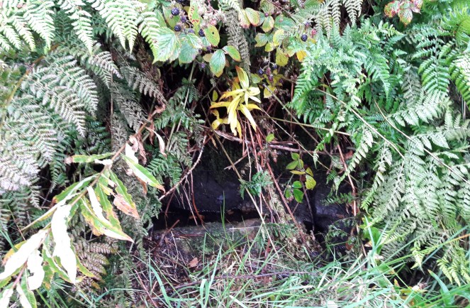
The stone, when you come upon it, is very easily seen, despite being tucked away and in the shelter of an oak tree.
Nestled in an Oak tree, the stone sits at a jaunty angle on the left hand side as you come down the track from the Whitfield end.
What is immediately obvious, more so on the ground than on the map, is that the stone marks the point where a track branches from Carr House Lane down to Whitfield Barn. Whitfield Barn is at least 18th Century in date, and probably earlier in origin, though without closer inspection is impossible to tell. The main track continues down to Carr House, a farm building of similar date, and which lends its name to the pathway.
This is significant, as it is exactly the sort of place one would expect to find a cross, marking a track junction (see here and here, and the comments for both, for discussion).
The track down from the Whitfield end of Carr House Lane.Carr House Lane as it continues down from Whitfield to Carr House itself.The branch that comes off Carr House Lane down to Whitfield Barn. The cross lies just out of shot to the right.
And yet it is not a true cross, not in the general sense anyway – it is simply a stone with a cross carved into it. I think it likely that the stone was there long before the the cross, and that it was originally a waymarker making sure the track down to Whitfield Barn wasn’t lost, particularly in the dark.
Now, it is just possible that it is a standing stone, by which I mean a prehistoric standing stone – there are several in the area. However, this interpretation is problematic. Firstly, a prehistoric standing stone is just that… a standing stone, erected in prehistory. However, a standing stone erected yesterday will look exactly the same. Thus, without any associated datable features (a barrow, a stone circle, a burial), we cannot state that the stone is prehistoric. Could be, but might not be. Secondly, its situation, at the junction of the tracks, suggests a connection with, and thus a product of and post-dating, them. It could be argued that the tracks are situated to take into account an already existing stone – that is, the track to Whitfield Barn could have been made anywhere along Carr House Lane, but it made sense to split it at the stone – but again that is impossible to prove.
What I will say is that the stone certainly isn’t a disused gatepost, nor is it naturally occurring in that upright position. Which means it has been placed, with purpose and meaning, by someone. Neville Sharpe, in his book ‘Crosses of the Peak District‘, states that it has been shaped, which is certainly the case, so it seems some thought and care has gone into what it looks like.
The cross carved into it is interesting, also. It has been suggested that some roadside crosses were placed as a gift of thanks for the completion of a safe journey, effectively a votive offering in payment for an answered prayer (i.e. help me get home in this awful weather, and I’ll set up a cross to say thank you). They might also function as a spiritual fortifier, reminding the traveller of God’s watchful eye and protective power over the faithful. It is easy, in these days of surfaced roads, street lights, and large settlements, to forget just how dark and treacherous travelling in the pre-modern era would have been – making your way from A to B in total darkness, along a muddy track, and with no map as such, and knowing that if you took a wrong turn somewhere, you were lost. And I find it difficult enough to find the bathroom at night!
That stated, there is something about the cross that suggests to me that it seems to have been more of an afterthought – the result of a sudden onset of piety perhaps, long after the stone was set in place.
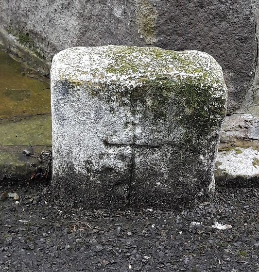
Close up of the carved cross. I really need to go back and re-photograph it properly.
It is two simple chisel strokes, one vertical, one horizontal, and the job is done. Why go to the effort of raising and bedding a stone that weighs 1/4 tonne, perhaps more, and then just carve a simple cross into it? The cross is not particularly well executed, either – it is certainly not the effort of a stonemason or even someone familiar with stone. Sharpe (p.42) suggests that it was cut “a long time ago” as the cross would have been vertical when carved, and age has slumped the stone. Logically, this is a sound argument, but the fact that there is an Oak tree growing behind it and to the left (i.e. the direction from which it would push the stone) may suggest a more modern date. Whatever the case, I would suggest that the raising of the stone and the carving of the cross are two separate events that probably occurred many years apart.
What I do find intriguing is that the carved cross strongly resembles this mystery carved cross. Well, obviously… it’s a cross, one of the simplest and easiest designs you can carve onto a stone surface. But the cross design, two simple strokes, thin and unfussy, but seemingly not done by a professional, is similar. Moreover, it is something of a coincidence that two seemingly random stones, separated by roughly 700m, both have a very simple cross design carved into them, and probably as an afterthought. I wonder if someone in the area caught a little divine inspiration and went on a carving spree? And I wonder, if we keep our eyes open, will we find any more?
As always, thoughts, comments, and corrections are very welcome.
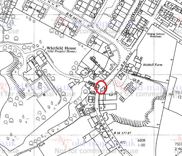
Here’s a strange one, and one that may have a perfectly reasonable explanation, but it is a bit of a mystery.
First some context. I have always been intrigued by free-standing stones, and the multiple uses to which people put them. From glacial erratics to carved crosses, and from prehistoric standing stones marking a ritual space to boundary stones marking a modern urban district boundary, we rely on the natural material as a marker, as we have since we first found a need to mark place. There is something very human about a stone marker. A lot of my work in archaeology has been involved exploring space, and how we mark it, how we make it different from other space (specifically, in my case cemeteries and ritual places). I won’t get too bogged down in the detail here – I have a bigger post planned that explores some of these themes (you’ve been warned… and there will be questions afterwards), but for now, I present the first entry in a series entitled “The Stones of Glossop” that will explore the multitude of free-standing stones that populate the area.
And it is a bit of an odd one.
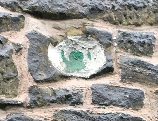
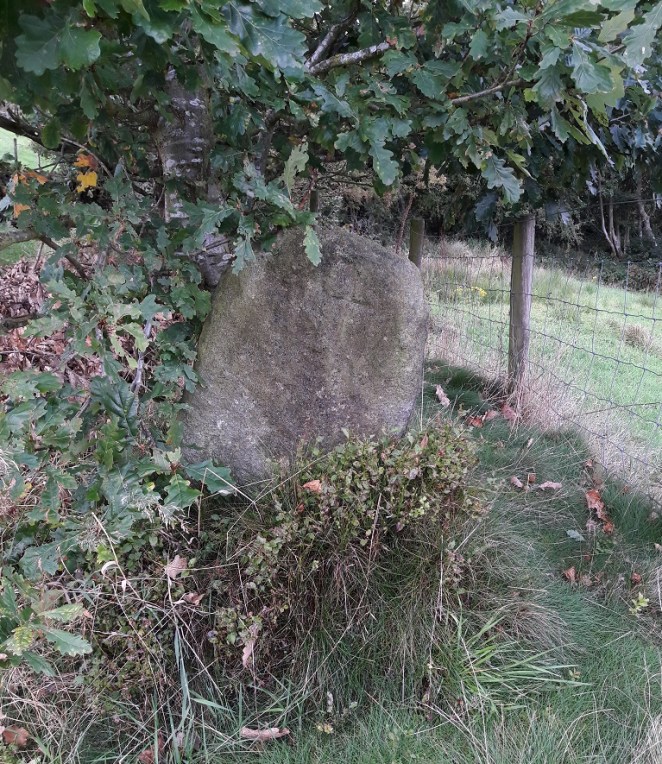
Walking on Hague Street, heading toward Derbyshire Level, and just past King Charles Court, the road bends to the left and passes very close to the 17th Century House there. Just on the corner of the house, and placed on the kerb, is a small stone.
Here!
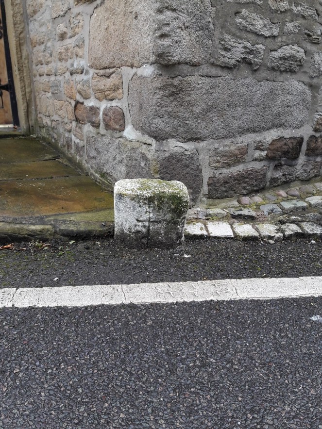
Less than a foot high, rectangular, and dirty, it was once painted white, making it very visible, one assumes, in darkness. What makes this stone particularly interesting is the neat cross carved on the front.
The stones of the 17th Century house are clearly visible behind, with what, I have just noticed, looks like a face carved into the uppermost stone in the photograph. Coincidence, obviously, but spooky nonetheless!
The cross is of the Christian variety, with an elongated vertical piece, and is very clearly intentional, with the grime of the road and many winters highlighting the effect. There may be other marks on the front surface, but it is difficult to tell if they are intentional or the result of wear and tear. It is worn, especially on the right hand side, but not as much as I would expect if it were particularly old, especially situated by a roadside, and the stone has largely maintained its rectangular shape. It has also been painted fairly recently; this may be the continuation of a tradition of painting roadside stones, or it might have been done for the first time two years ago.
Close up of the stone and the cross.
It may be modern – although that would be perhaps surprising – or it may be older – in which case, why does no one mention it in any of the texts? It could be a road marker, but there is a massive building behind it that marks the road in a much more clear way! And what is the purpose of the cross? I suppose in some way it should be considered a roadside cross, but if that is the case, I’m not sure how to interpret it. I quite literally know nothing about this oddity.