Archaeology · Pottery · Where / When

Updates: Cheese Town and Other Matters!

What ho, you wonderful – and slightly odd – folk who are reading this. You are here either because you have an interest in Glossop/Pottery/Old Things/The Ramblings of a Sherd-Nerd… or you’re lost. Either way, you might need some help. And either way, pour yourself a glass of the stuff that cheers, sit back and relax.

So then, we have a mixed bag today – some updates and some new stuff, and first up we have placenames.

WHITFIELD: THE PLACENAME

I originally published this post listing all the places in the Glossop area with their first appearance. Whitfield first appears in the Domesday Book of 1086 under the name Witfelt, which is normally understood to mean “White Field”, meaning an open (figuratively ‘white’) land or field, presumably to differentiate it from the surrounding moorland. However, I recently read an interesting article in Nomina: the journal of the Society for Name Studies in Britain and Ireland… as one does. The article is titled “Onomastic Uses of the Term “White“” by Carole Hough (read it here). Briefly, it suggests that amongst all the other possible meanings for the word ‘hwit‘ (White), one that is often overlooked is that relating to dairy foods and milk – literally ‘White Meat‘ – for which there is a lot of evidence, particularly when used in conjunction with a farm or land place name element. If we consider this in relation to Whitfield, we might understand it as the field where diary produce is made, and hence the Cheese Town of the title. We can’t say for certain, but it’s certainly a possibility that should be considered, for as we know cheesemaking was taking place here in the 18th century and earlier… so why not? Whitfield, land of cheese! Marvellous!

MASONS MARKS ON LONGDENDALE TRAIL

Back when I was a younger man (April 24th 2018, according to my records… 6 1/2 years ago!) I published an article on Mason’s Marks and Apotropaia on the stone infrastructure on the Longdendale Trail (read it here). Master CG was only just 2 years old then… and a lot can change in 6 1/2 years! Having recently got into riding his bike (!), off we went to the Longdendale Trail, giving me the opportunity to look for more marks… and Lo!

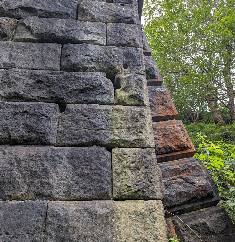
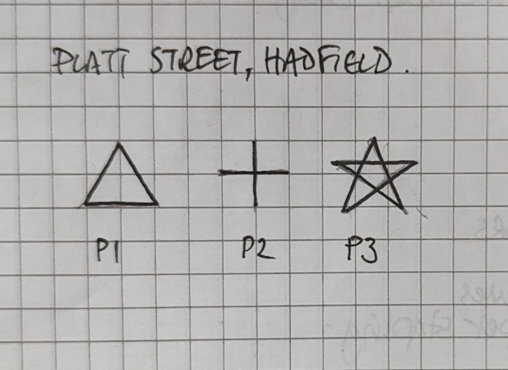
Here are the marks so far identified, to add to the corpus of mason’s marks along the line. The first are from Platt Street, the road bridge at the very start of the Longdendale Trail (What3Words is fortified.bracing.wage).

Photographed from my notebook… I just realised I should have rubbed out the pencil!

The second lot are from under a bridge that carries an apparently unnamed road leading from Padfield Main Road to Valehouse Farm (What3Words is leader.operated.courts).

V8 is also shown in the Platt Street marks. Some of these show up at other places along the line. Ooooh, I can’t wait to collate and analyse… I’m such a geek!

As you can see, some of these marks show up elsewhere on the track, suggesting that the same workers were shaping stone all the way from Broadbottom to Woodhead, which makes sense. Truly though, I need to survey the line properly, collecting the forms and locations, etc. I know I’ve said it before, but I honestly think a wonderful project could be made from these marks; recording and comparing them all along the line, researching who they might belong to, raising the profile of the men who physically built the line (not just those who financed it), as well as approaching it from an arts perspective. There’s lots to pick away at here, in fact… if anyone fancies joining me (or indeed, if anyone fancies funding/sponsoring me).

MYSTERY STONES ON THE GLOSSOP – MANCHESTER LINE

Talking of stones, a few years ago I published an article that looked at some odd stones I had noticed during the commute between Glossop and Manchester. Please read the article for more in-depth information, but essentially, 2 pairs of stones and a single example, all exactly the same shape and design, and all with the same single letter designs – ‘I’ and ‘G’. One pair on the platform at Guide Bridge station, and the single example just beyond the station, against a wall, and both of which I had photographs. And another pair just before one pulls into Hattersley station (coming from Glossop, on the right), which was in a ‘blink and you miss it’ position, and consequently of which I had no photograph.

The pair at Guide Bridge
The single post (possibly originally one of a pair) a little further on from Guide Bridge

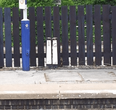
And there the matter lay until the other day! Heading into Manchester, I noticed we seemed to be slowing down earlier than usual on the approach to Hattersley station, and having my phone in my hand, I tried to get a shot of the stones… and succeeded. Well, sort of… in a cruel twist of fate, young Master CG decided it would be an ‘hilarious’ jape to put sellotape over the cameral lens, and as a consequence the photograph looks like it was taken using a potato. Still, the jokes on him… I subsequently enrolled him in a special after-school long-distance running and extreme maths challenge club. That’ll teach him to mess with old TCG! Anyway, here’s the photograph:

Apologies for the poor quality, but the general area can be discerned.
The ‘G’ and ‘I’ can just be made out through the sellotape haze. I will keep trying to get a decent photograph.

So now we have photographic evidence of all of these mystery stones, which is great… but we still don’t know what they are! So, please, if anyone can suggest a meaning or purpose behind these “monogrammed mushrooms” as I have named them (patent pending), then in the name of great Jove, please let me know.

OOOOH… FLINT!

More stone… this a little older, though. Over the course of a number of years, I have picked up a few odds and ends of prehistoric flint from the Glossop area. The hills all around are full of these tiny fragments of a distant past – largely Mesolithic (Middle Stone Age, roughly 8000 – 4000 BC), with some that might be Bronze Age (roughly 2500 – 750 BC). But these three examples I have found much closer to Glossop itself, and always quite by accident. It is worth remembering that Glossop, the Peak District, and indeed most of the North West is not a flint area, and any flint found hereabouts has arrived either by glacial action, or it has been brought here by a human; so any flint you see pick it up! Honestly, flint and chert (a local, poorer quality, flint-like quartz) are both very distinctive against the local gritstone, and once you get your eye in, they stand out from some distance. I’m not a stone man, and whilst I can usually recognise flint that has been shaped deliberately, the finer points of dating I leave to people who know what they’re talking about. Here are the bits I have found:

This first came from a path just below Shire Hill, so might be Bronze Age.

Lovely stuff – a blade made from a chip of flint. You can see the ‘bulb of percussion’ – the bulbous bit at the top – where the blow was struck to break this chip off. When hit, flint acts as though it was liquid, and you can see the ‘waves’ made by the strike. You can also see the nibbling at the edges that suggest this blade was ‘retouched’, or sharpened after being used. Flint is very sharp (I have literal scars to prove it), but it is a fragile edge that needs work to maintain it.
The back side of the above flint piece – you can see where other pieces have been struck from this one, each creating a scar as the force travels along the core. It’s a fascinating subject flint knapping, and one that is not easily put into words… it has to be seen, and especially felt.

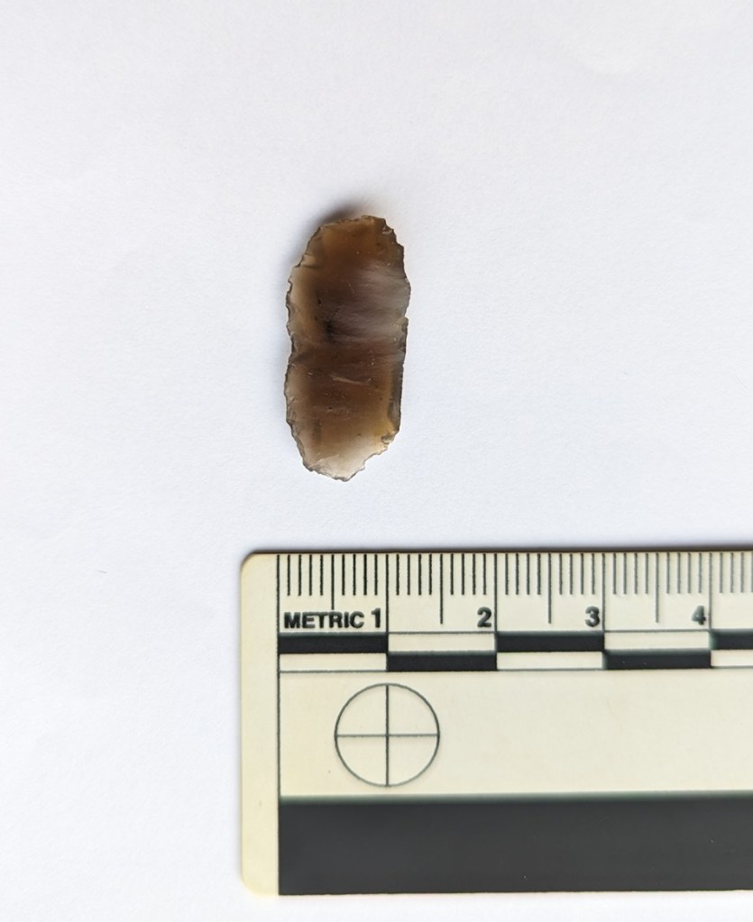
The next flake came from where the allotments are now at Dinting, sitting on a mole hill.
A chip off the old nodule! It’s been worked, but I’m not sure it was ever a tool.
Again, a crappy photo of a lovely flint tool. This time, a fragment of a thumbnail scraper – also here. Honestly, flint is better touched and seen in person, that’s why we archaeological types use drawing to illustrate flint… a photograph does not show what we want to see.

Whilst we know people were here in prehistory, its always nice to see the things they used in their everyday lives. I actually need to report these to the Find Liaison Officer (FLO) as this is prehistoric, and any information from this period, no matter how small, can potentially change our whole understanding of the history of the area. The FLO is the person to report anything interesting and potentially important you find (feel free to tell me as well, but honestly they are more important) – very helpful and genuinely the font of much knowledge.

POTTERY: SOME BITS AND PIECES

Never missing an opportunity to spread a little ceramic-based joy, I present to you a small selection of recently found pottery. Following my own newly introduced rules, I am only taking sherds that interest me, or which are good examples of the ware type. This means that there is more left for you wonderful folk to find, and more space in chez CG… much to the relief of Mrs CG.

First up, two very similar sherds.

Left has heavily crazed glaze, and I suspect it was burnt at some stage… that’s not normal ‘wear and tear’, even after being in the ground for 200 years or so.

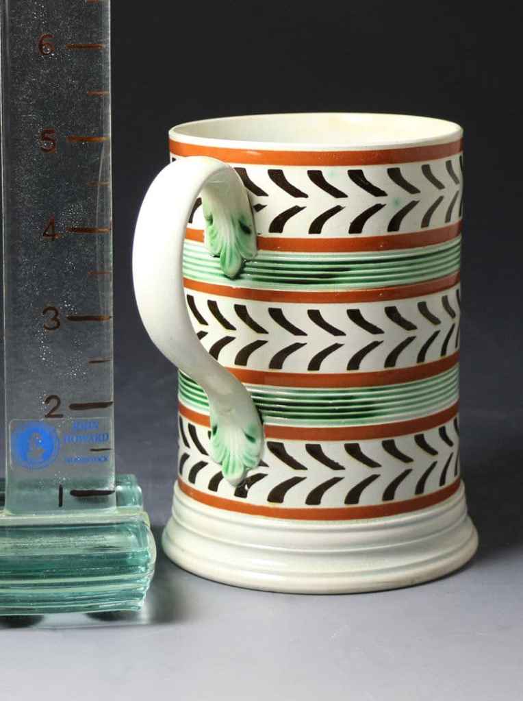
Left is from High Lea Park in New Mills, and is the base to a mug or tankard some 8cm in diameter. The right was found on the track below Lean Town, and is the same in shape and dimension, although this is from the body somewhere, not the base. I got very excited both times I found these – they look like Scratch Blue stoneware, which would be very exciting. Alas, on closer inspection it’s clearly earthernware, and thus less exciting. Having said that, they are both from Industrial Slipware vessels, and both early 19th century in date – which is a bit rarer than the usual Late Victorian – and come from something like this:

Stolen, as always, without shame, from this website. Honestly, it’s a fascinating website filled with all sorts of historical pottery information from a collector’s perspective. I genuinely enjoy this site… which might be warning to some of you!

Sometimes, coming back from school with Master CG, we like to shake up what is in essence a somewhat linear journey from A to B by taking different routes; exploring, Wandering, and just seeing what we encounter along the way; blackberries, elastic bands, the occasional copper nail, a penny, holes in the ground to peer into, and if we are lucky a skip. There’s always something in either of those two latter.

Plain, but is still quite cool. I know, I know… but I can’t resist!

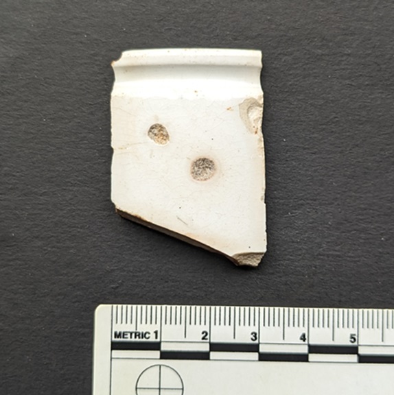
This was from a skip on Hadfield Place. Always, and I mean ALWAYS, look in a skip that has soil piled in it: Glossop’s history almost guarantees that there will be at least some Victorian sherds in that soil. Here we have a rim sherd from a late Victorian/early 20th century marmalade pot – something like this:

Stolen from this website… and you can buy it for £55.

The groove running around the pot, just below the rim, is to enable a piece of string to be tied around to keep the cloth lid in place… very characteristic.

Skips and holes… always have a look in both. This next sherd was from a utilities pipe trench on St Mary’s Road:

Lovely stuff. I think this might be fairly early

A lovely sherd of Industrial Slipware, again, this time of a Banded or Annular Ware type. It looks very modern as it is still made, particularly as Cornishware, but it is genuinely early to mid-Victorian in date, and probably from a large bowl or jug. Looking and feeling it again again, I think jug.

This last sherd is another Industrial Slipware – a tiny fragment of Variegated Ware, this one being in the ‘earthworm’ design:

Truly awful photograph. I know a bad workman blames his whassnames, but my new phone has no macro setting, so my up close photos are not great.

Probably from a jug or bowl, similar to the one in the above article, and dates to about 1800-1820. Interestingly, this one was found in a quarry that was used during the construction of Bottoms Reservoir, and was later used as a tip. Bottoms Reservoir was opened in 1877, and thus the tip can only have been used from, say, 1880 onwards, and actually, judging from what is found there, I think perhaps from 1900 onwards. This means that this sherd – and the pot it came from – was as much as 100 years old when it was broken and thrown away. This makes sense – I still have my great grandmother’s 1920’s salt-glazed stoneware pie dish (I use it to make a really nice tomato and white bean bake with a feta topping, if anyone fancies…) – and is a cautionary tale about using pottery to precisely date certain contexts. People in the past also had heirlooms, and all objects have a biography.

AND FINALLY… WHERE/WHEN 3

Well, Where/When no.3 is now on sale… and selling well. You good folk seem to like a walk, some history, and a pint… who knew? Well, I think we all did to be honest. You can get it in Dark Peak Books (93 High Street West in Glossop), or via the Cabinet of Curiosities shop (here). Or you could track me down and snag a copy.

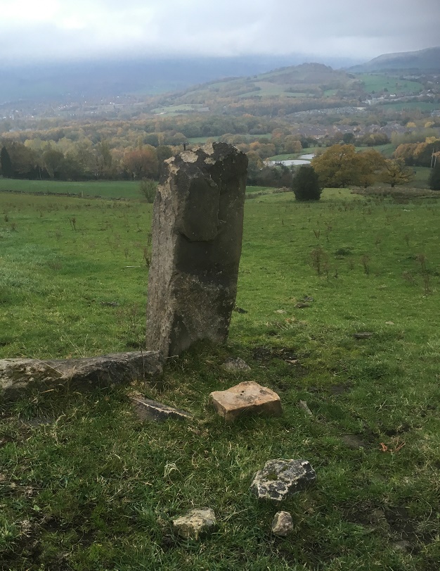
For those of you who are unaware, Where/When is a quarterly journal of Archaeological Wanderings. Essentially, a walk in the Glossop area, with yours truly chiming in about the archaeology and history of where you are wandering; think a pinch of pottery, a hint of psychogeography, some groovy photographs, a dash of discovery, a toe stub of psychedelia, and a splash of the usual Glossop Curiosities shenanigans. No.3 Takes us on a walk from The Beehive in Whitfield to The Bulls Head in Old Glossop via medieval trackways, a Saxon stone cross, 18th century buildings, and a 10,000 year old glacial erratic boulder. Marvellous stuff!

A sneak preview of Where/When 4 – The Melandra Meander.

And Where/When No. 4 is in preparation; titled “The Melandra Meander“, it will detail a circular walk from Melandra Roman Fort to Mottram Church on the hill above – via Hague and medieval trackways – and then back again, and is full to the brim with the kinds of historical and archaeological goodies that you have come to expect. It’ll be in stores in December, just in time for Christmas.

I have a whole pile of ideas for Where/When, and the Cabinet of Curiosities in general… all kinds of stuff: t-shirts, anyone? Art prints? The Rough Guide to Pottery in booklet form? And in particular I’d like to start a series of monthly guided Wanders – where you and me can Wander together. Let me know what you think about this. Or indeed anything about the website, or what I have written. It’s nice to know I’m not just shouting into the void!

Right then, apologies for the late post of this article, and for generally being behind in most things – there’s often a lot less of old TCG to go around than I believe, so I end up dropping some of the things I’m juggling. More soon, I promise.

Until then, though, please do look after yourselves and each other, and remember – a person might look ok on the outside, but can be struggling inside. We all matter.

I remain, your humble servant,

RH

Standing Stones · Stones of Glossop

Standing Stones

So, apologies for the late running of this blog post. I have half a dozen half-written posts at any one time, and this one seems to have had a difficult birth! It was finally scrawled on the back of the minutes of the AGM for the Glossop & Longdendale Archaeological Society in a cafe whilst waiting for Mrs Hamnett to come out of surgery in Wythenshaw Hospital! (All is good on that front, and she is making a recovery). Apologies also for the length of this one, and for the archaeological theory. I do love a good bit of interpretation, and in my previous archaeological life this was the stuff that nourished!

I was having a conversation with my brother-in-law the other day (Hi Chris), and he asked whether I had seen the standing stone on Long Lane, between Charlesworth and Broadbottom Bridge. As it happens, I had, and it was on my ‘to do’ blog list.

And here it is, being done… well, we’ll get to it in a minute

Standing stones and stone circles are some of the things that first grabbed me when I began to look at archaeology seriously. The fact that they were a tangible and impressive representation of the past made them stand out, and yet they were enigmatic – their function and meaning still not fully understood. Single standing stones in particular have been overlooked as monuments; their very nature – a single stone, standing upright – has meant interpretation is difficult. Moreover, they are largely undatable unless associated with other monuments such a stone circle, and people throughout history have stood stones upright, and for a variety of reasons (cattle scratching post, waymarker, gatepost, etc.). Generally, though, they are considered to belong to the later Neolithic and Early Bronze Age (roughly 3000BC – 2000BC). As to their function, they are often viewed as marking a territory, or as a meeting place, usually with ‘ritual’ overtones. In more recent times, they are often associated with folklore and the supernatural, and even leylines.

STST 1
A stone beside the River Etherow, in Broadbottom. This one is, I think, a glacial erratic.

Recent archaeological work has begun to unpick the possible meanings and functions of many of the monuments of prehistoric Britain, and especially those of the Neolithic. This has been done more subtly and intuitively than previously, and looks at monuments in their surroundings, and how the people would have experienced, used, and passed through them, rather than viewing them as just objects. Words like landscape and phenomenology are used, and it often draws on other disciplines such as philosophy to help with understanding the past. Extrapolating from this work at the larger monuments, and in particular the pits, causewayed enclosures, and chambered tombs of the Early Neolithic, we can use some of these ideas to explore a possible meaning of the standing stones of the Late Neolithic and Early Bronze Age.

As I’ve said before, a standing stone is just that, a stone, standing. But conceptually, it is much more than that, it is a fixed point in the landscape, around which human experience can revolve, and emerges from a concern with marking a particular space as being different from it surroundings, transforming it, and placing it within the landscape but apart.

It is clear that the actual creation of monuments such as these was just as important as the finished product, and the erection of a standing stone is not a simple task. It requires group work and cooperation; with the stone weighing perhaps a ton or more, families, extended families, kinship groups, or even clans would be working together to make the stone. It would be a period of community, sharing work and food, and the creation of joint place. The stone would have to be shifted and shaped, and here we have decision to be made. From where is the stone to be quarried? The source may be significant to the people creating the monument, and perhaps that quarry or stone type already figures in their stories and beliefs, already a sacred site. Although practical considerations are possible, it may not always be the case – the Stonehenge Bluestones were moved by land, sea, river, and land from the Preseli Hills in Wales – a journey of over 150 miles, because they were deemed important. Our practical concerns are different from theirs.

Then we must consider location, why was the stone sited where it was. The larger monuments, such as the enclosures of the Early Neolithic, often have evidence of earlier occupation, and it seems that the monuments are referencing these flint scatters and back-filled pits, a way of acknowledging those who went before – the ancestors. It may be the case with the standing stones. But equally, they may reference something else – a feature of the landscape, or perhaps some other, more numinous reason which we would never be able to fathom. Did a shaman have a vision suggesting the site? Or did lightning strike? Or someone die there? Or… you get the idea. And did the stones stand on a bare hillside as they do now, or did they lurk in a bright woodland clearing?

Stst11
Another stone by the River Etherow. This one is shaped, and was perhaps a gatepost.

Once in place, the people responsible for erecting it might visit periodically – every year on midsummer’s eve, for example, or every full moon, or when the cattle are herded from lowland pasture to the upper areas, or even every day. But certainly through these periodic visits it would be seen as, calendar-like, marking time, or even creating a ‘mythic’ time, outside of ‘real’ time. They might have visited in large groups, taking the form of kin-related clan-wide celebrations, for example, or perhaps in small family groups, or even as individuals. Each visit would recall previous visits, previous times of coming together in celebration, or in mourning, for example. But there would be feasting and celebrating, certainly, with people gathered in their groups round hearths and fires.

Perhaps the area around the stone was kept spotlessly, meticulously, clean, and each visit revealed traces of the old hearths clearly, and the conversations, people, exchanges, jokes even, that happened around those hearths would be recalled and spoken about. And it’s not hard for us to imagine a group of people, framed by firelight, moving in a circular fashion around the stone, dancing. But perhaps, and I suspect more likely, the area around the stone was littered with the detritus of these older meetings – pottery, animal bone, flint, pits dug into the earth, stone, and other bits and pieces, all deliberately displayed as a reminder of the past visits. There may well have been human remains, too, in the form of cremation or as an internment, or even random bones, carefully kept and handled – curated for generations – before finally being deposited around the stone. Each item or object speaking to the people of the past, of past lives and events, and of the ancestors. With each visit, again and again, there was the creation of new memories, new meetings, and yet still the recollection of older ones – the ancestors would have loomed large and heavily in these times.

The stone here acts as a mnemonic device, an object that helps us remember. That is its purpose, its meaning… to help us recall previous visits to the stone. Using the stone as a focus in this way, time can be manipulated: the individual can visit past people and events, travelling and recalling; but equally the ancestors and past gatherings can be brought into the present through shared memory. Importantly, the ancestors can be projected forward into the future, asking for their intercession for a good harvest, for example, or for help and advice.

And of course, when the people gathered together for feasting and celebrating, there would have been exchanges in the form of gifts and barter – and from hearth to hearth, and valley to valley, there was an exchange of resources, news, gossip, alliances, ideas, beliefs, objects, allegiances, skills, animals, marriage partners, and so on.

In fact, all the drama of human existence revolving round this fixed point in the universe, a node, a single stone standing in not just a physical landscape, but in this case a cultural landscape, and on a personal level, a psychological landscape.

Phew!

So then, the stones…

  • Hargate Hill Stone

Let’s start with the stone that sits on the corner of Hargate Hill Lane and High Lane, the road between Simmondley and Charlesworth. It’s here:

STST3
The stone is circled. The air shaft to the right is the mine shaft down which Albert Burrows, the Simmondley Pit Murderer, pushed his four victims – the subject of a future blog post.

Here is the stone.

STST5
The standing stone above Hargate Hill. Mouselow Iron Age Hillfort is in the background.

The stone is very obviously deliberately placed, and sits on the junction of two tracks, both clearly ancient, and like many standing stones, it stands mid-slope, i.e. not at the top or bottom of the hill. It could be argued that the stone is placed as a marker for the tracks, but I suspect that the track from Hargate Hill used an already existing stone as a sight marker. Interestingly, Neville Sharp suggests that its chisel-like head points towards Shire Hill,  some 3km north west of the stone. And yes, seemingly it does.

stst6
Shire Hill looms darkly through the murk.

This may be important. It is not uncommon for standing stones to reference features like this, and Shire Hill is fairly prominent in the landscape, even on gloomy days, it can be made out easily, as the above photograph shows. Interestingly, in the mid 1950’s, the cremated remains of a female dating to the Late Bronze Age was uncovered on the south slope of Shire Hill during the building of a bungalow there. The remains had been placed in an upturned burial vessel, which was laid on a bed of charcoal. Sadly, there is very little information available about this important find. Out of our period, but points to prehistoric activity on the site.

There is, marked on the 1887 OS map (see above) another stone just to the east of this one. I have looked but cannot find any remains of a stone, even a small one, and not even reused as part of a wall – whatever was there in 1887 is no longer there now, sadly. But it is worth mentioning that standing stones sometimes occur in pairs.

  • Hague Stone.

I found this one years ago – I did a ramble in search of this stone and Pymm’s Parlour Roman rock shelter on the banks of the River Etherow (the subject of a future blog). Finding it was not easy, as it now tucked away in a wooded area, and for some reason I didn’t take any decent photographs… not sure why.

stst9
Hague Stone marked in red, Pymm’s Parlour (here Prim’s), a Roman rock shelter, in green.       1898 1:2500 OS map

Here’s the stone.

stst10
The Hague Stone, dead centre, disguised as a tree. Apologies for the photograph.

It’s a fairly hefty stone, as you can see, and tucked away, though the 1898 OS map shows it as standing in open fields. I will get a better photograph this winter, I promise! Not a great deal to say about this stone, though I think it is important, as we’ll see.

  • Long Lane Stone

Very visible from Long Lane, this stone has long intrigued me.

stst8
The Long Lane Stone marked in red. Another stone is circled in green. 1887 1:2500 OS Map

I have been unable to get a decent photograph of the stone, as it stands in a field that grows turf for Lymefield Garden Centre, and one doesn’t like to trample on the new grass (and I don’t recommend you do either). Every other time I’ve tried, it’s been too dark, too bright, etc. So here is the Google maps version. I’ll keep trying, and replace when I can.

STST7
The Long Lane stone. Long Lane is behind the camera, and Charlesworth to the left.

It’s a fairly bog-standard standing stone, shaped and set into the ground in the middle of a field. The 1898 OS map shows it standing at the head of what it describes as an ‘Old Quarry’, something that the earlier maps don’t show. I can’t believe it’s a quarry… what would they be quarrying here? A marl pit perhaps, but not a quarry. Perhaps it is a feature associated with the stone? What I do find interesting is that the stone hasn’t been moved – either in the past, or more recently, in order to make harvesting the turf more easy. Folkloric associations with bad luck? Whatever the reason, it’s great that it remains

As with the Hargate Hill stone, on the 1887 OS map, there is another stone marked, south of the main one, further up the hill toward the church (in green on the map). I have not been able to investigate this as it now stands on very private property, behind a locked and alarmed gate. I have not been able to see anything on later maps or aerial photographs, and it may just be a small unrelated stone – the early OS surveyors marked anything that couldn’t be moved on their maps. I would still like to investigate though, so if anyone knows anyone or anything, please let me know.

Now, these last two stones, for me, are particularly interesting. Let’s play a game of ‘what if’ Assuming that the stones existed at the same time, they would have been intervisible – you could see one from the other. They stand on opposite sides of the river, and on opposing hillsides, but are at about the same elevation, and both middle hill, not at the top. In a sense they are facing each other, and we may understand them perhaps as rivals, representing two different nodal points, perhaps for two different clans. But what if, instead, they are viewed as complementary? What if we take them together, as a pair, making a statement? The location of the Hague stone is at the head of the valley, just past the Besthill Bridge and the cliffs of Cat’s Tor there. The cliffs are steep and difficult, and logically the slope where the stone is located is the first patch of land that would allow it to be dug in. I feel almost certain that the stone references this point, and that it is placed at the head of the Longdendale Valley.

STST2
The view from just about where the Hague stone is. The Long Lane stone is far to the right, the Longdendale Valley is opening out ahead, and the Iron Age Hill Fort at Mouselow is middle right.

If we accept that the Long Lane stone references the Hague stone, then we seem to have a pair of distant, yet connected, stones standing at the head of the Longdendale Valley – gateposts of a sort allowing you access into the valley, and which form a part of a larger landscape, shaped and controlled by the people in prehistory. This puts a very different spin on the place, and suggests all sorts of areas for further research.

Of course, it is all ‘what ifs’ – a story if you will, and one that is completely unprovable. But it is possible, and I genuinely believe that the Hague stone at least is there for that purpose; you often find stone circles situated at the confluence or head of valleys, so why not a single (or pair of) stone(s)? Something to think about, if nothing else.

If you are interested in the ideas about British prehistory that I have been talking about, there are a number of very good books on this subject. I would recommend starting with:

  • Britain BC by Francis Pryor                                                                                                         An excellent and easily read overview of prehistoric Britain. Really very good.
  • Stonehenge by Mike Parker Pearson                                                                                         A compelling & easily read account of the Stonehenge Riverside Project, and in   particular it covers Parker Pearson’s theory that stone = death, and wood = life.
  • Ancestral Geographies of the Neolithic by Mark Edmonds                                                   Academic, but a good and accessible read. Full of wonders. Highly recommended.

These next are academic archaeological books that are a bit more complicated, and require some background knowledge.

  • Understanding the Neolithic by Julian Thomas                                                                        Essential reading, but very dense. Not recommended for the casual reader.
  • The Significance of Monuments by Richard Bradley.                                                                Another good one, dense in places
  • Ritual and Domestic Life in Prehistoric Europe by Richard Bradley.                                    Again, really good, and quite accessible. It covers the whole of Europe.

As always, any comments, questions or corrections are welcome, just drop me a line – either email in ‘contact’ above, or in the comments section below. Next time I’ll blog about some interesting pottery… I think.

Your humble servant,

RH