Waterways of Glossop

A Lost Whitfield Waterway

What ho! Greetings one and all. Come on in and take a seat. Can I get anyone a drink?

Today, I finally finish a blog post that was started 2 years ago. Not for any particular reason, it’s just that some posts are more urgent, and others seem to, well, ferment… if that’s the word I’m searching for. If it isn’t, it’ll have to do.

So, I was reading a little bit about the history of St James’ church, the parish church of Whitfield. And a splendid one it is too. Living in Whitfield, I have a strong attachment to the church, not least of which I can see its spire from my bedroom window, but also Mrs Hamnett and I were married there. And by a spooky coincidence my namesake and pseudonym – the original Robert Hamnett – was a member of the congregation and is in fact buried in the graveyard there, something I didn’t know at the time of my nuptials.

The church was built in 1845 (and consecrated in 1846), on land that was bought from the estate of Thomas Dearnley, of Tintwistle, a schoolmaster who had died in 1842, at a price of £110. This land – Lower Meadow as it was originally called – was described in the deeds as being bounded by “Holly Cross Lane and Wall Sitch“. Holly Cross Lane – now known as Hollin Cross Lane – makes sense, but Wall Sitch? Well, it is an unusual name, and, given my love of placenames and their meanings, I went digging. According to the paper “Semantic Structure of Lexical Fields” by David Kronenfeld and Gabriella Rundblad (2003:29) (no, I don’t understand what it means either… something to do with words, apparently) Sitch is “commonly used for (very) small streams, especially those flowing through flatland, and can be used for both natural and artificial watercourses”. It is derived from the Old Norse ‘Sik’, via Old English ‘Sic’, both meaning a marsh and/or a watercourse. It is not uncommon in the North West, and in particular those areas that fell under Dane Law (that is the area controlled by the Vikings, and subject to their laws). Glossopdale and surrounds is right on the border between Anglo-Saxon Mercia and Viking controlled Danelaw, so it is not surprising that we have a few Norse place names. Indeed, a little further up the valley, off Monk’s Road, is a ‘Sitch Farm’, which sits just above a small brook.

So then, I went looking for the Wall Sitch – the small watercourse by the wall – and do you know what? I think I found it, despite it being very hidden.

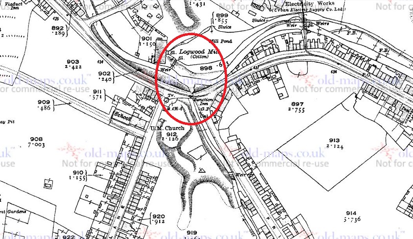
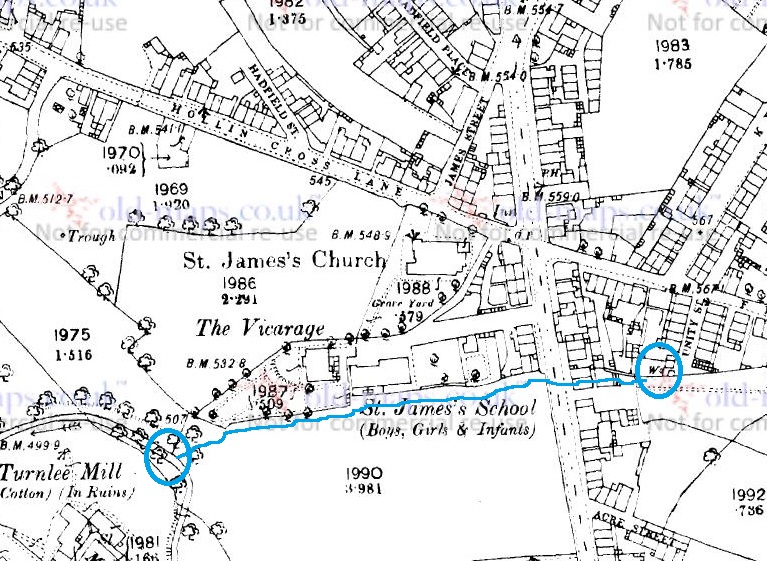
Here’s a map of the area, so we can see what’s what.

WS1
The 1880 1:2500 OS map. The church is central, with Hollin Cross Lane above it.

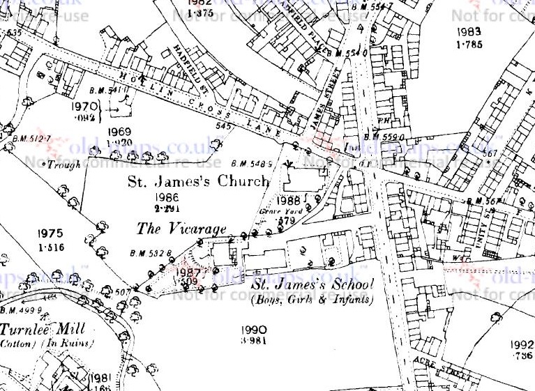
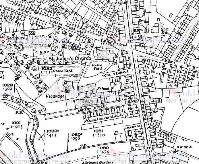
I first thought it might be roughly parallel to Hollin Cross Lane, so I looked at the south side of the churchyard. Nope… nothing on the ground, or on the maps. “But wait… hang on a moment!” thought I. The vicarage and St James’ school (the original one, not the newer one further up Pikes Lane) must have been built on church land too, and at the same time as the church, so I looked at the boundary below them. Well, it is immediately obvious there is no stream visible as such, but there is something very odd about the shape of the boundary – you can see it in the map above above the words ‘St James’s School’. Generally, when someone draws a boundary, it is straight, unless of course something stops it from being straight… and this one is a meandering shape. This type of ‘landscape archaeology’ can really help in identifying older or lost features, and I think it does here – the boundary has been determined by the course of the stream. So I went looking down Ashton Street (a road not yet built in 1880) to see what, if anything, I could see. Here it is on the 1921 map:

WS2
Ashton Street below the school. The meandering boundary has been straightened here.

And here it is in real life:

ws4
Ashton Street, looking west. You an see the slope of the road as it goes down to Long Clough Brook.

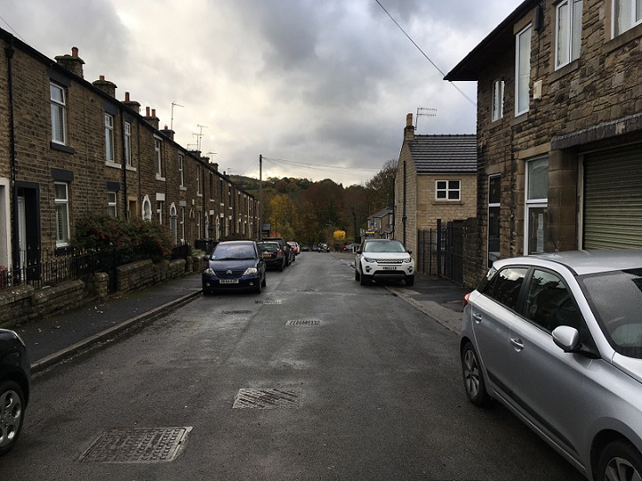
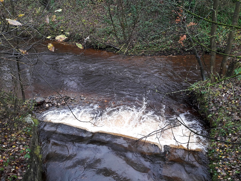
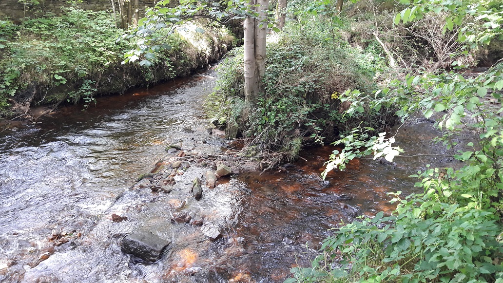
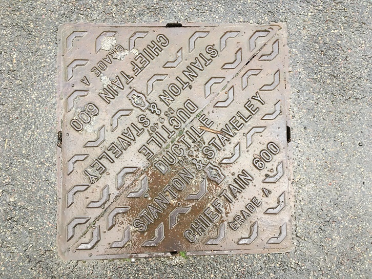
Well, disappointingly, there was not a lot to see. The school has been demolished – Master Hamnett now attends the successor school, built in the early 1920’s – and houses now occupy the site, although there are traces here and there. However, halfway down I heard a noise. Water! Below a drain cover in the road water was rushing, and then again farther down the hill toward the Long Clough Brook, below another drain cover.

ws5

This has to be it. I wondered if there was an outfall into the brook, surely the final destination for the sitch? And lo!

WS3
Wall Sitch outfall into Long Clough Brook.

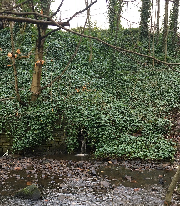
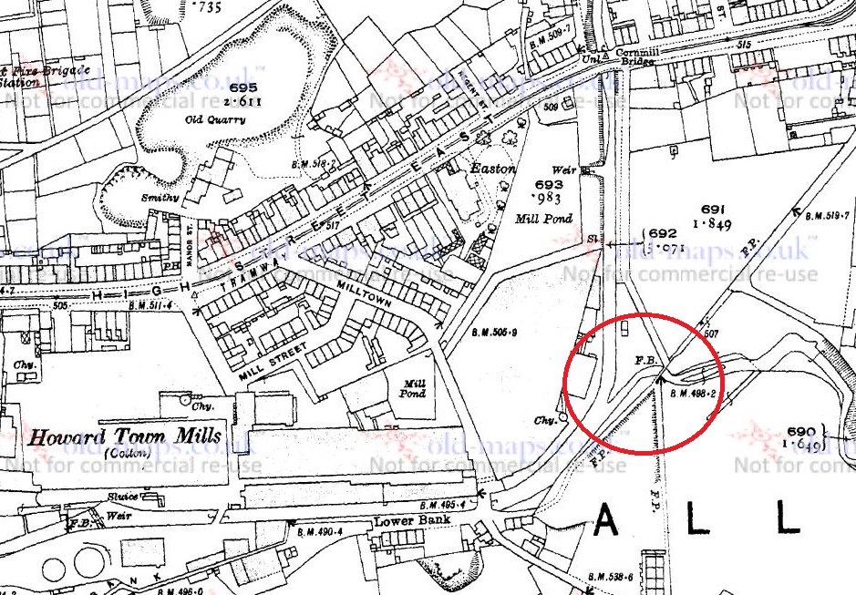
Excellent! I love detective work, and it’s exciting when a hunch pays off. This is exactly the sort of thing that I started the blog for. So there is the outfall, but it got me thinking… where is the start of Wall Sitch? Well, tracing the meandering line of the sitch back, and under Charlestown Road, it seems to stem from a well (marked with a ‘W‘ on the map below) at the end of Unity Street. Now, by coincidence this well was the subject of a previous blog post – check it out here – and although it is no longer there, clearly the water from what would have been a spring head, similar to Whitfield Well and many others in the area, is still running.

WS6
The probable route of Wall Sitch – from the well on the right, under Charlestown Road and along what is now Ashton Street, to the outfall into Long Clough Brook circled on the left

Makes you wonder what else is lurking, hidden in the ground, or in maps.

That’s all for now, but more soon – I have some posts that are 3/4 finished, so I should be able to get these published fairly rapidly. So, until next time, and as we head into another lockdown, take care of yourselves and each other. 

I remain, your humble servant,

RH. 

Waterways of Glossop

Long Clough Brook meets Glossop Brook

A short, place-holder, blog entry today. Real life is preventing me from posting as often as I would like, but I have a series of shorter posts to keep it ticking along whilst I work on a larger post. James is finally asleep, which means I get a cup of tea and some time to write this up… hastily. There’s washing up, laundry, and tidying to be done: being a 21st century househusband is not easy, and I raise my (Homburg) hat to my mother who made it all look so effortless.

So, in keeping with the post of the junction of two brooks here, I thought I’d do something similar.

Long Clough Brook starts in the valley to the west of the Grouse inn (now a house) in Chunal, and wends its way down along the valley, taking in streams and brooks as it goes. Of these, the most notable is Bray Clough Brook, which it joins at Charlestown. This is important, because at that point it becomes the boundary between Whitfield Parish (eastern bank) and Simmondley (western bank).

From Turnlee, it weaves in and out of Primrose Lane, and plays merry havoc with the boundaries – for example, the upper part of Slatelands Road is Whitfield, the lower part in Simmondley. And so it goes all the way down to the roundabout at the junction of Primrose Lane and Dinting Vale/High Street West, where the Junction Pub (now offices) stands.

Long Clough & Glossop Brooks
The confluence of Long Clough Brook (from the south) & Glossop Brook (running east-west at the top) is circled in red. High Street West is on the right, Primrose Lane and Simmondley Lane exit south out of the map. This is from the 1921 1:2500 OS map.

Here, on the other side of the road, it gushes out into Glossop Brook.

LCB
Glossop Brook, running east-west, is joined by Long Clough Brook from the south.

What is interesting about this is that the boundaries of three of the ‘villages’ that make up Glossop – Whitfield, Glossop, and Simmondley – are defined by this particular junction. In the photographs above, then, the land on the left is Simmondley, on the right is Whitfield, and the land beyond is Glossop. Oh, and the whole area is Dinting Vale, technically, just to add to the confusion.

And of course, it wouldn’t be a post by me without a Bench Mark! This one on the wall just to the east of the confluence.

BM
A mystery Bench Mark. Alright, so it’s not that mysterious.

Except, bizarrely, I can’t find it on the map. The only Bench Mark noted is on the old Junction Inn at 433.42ft above sea level, which annoyingly I forgot to photograph. This, is not to be found anywhere. It is also subtly different from the usual mark – the arrow doesn’t join the level, and there is another, probably associated, mark carved to the right. Nope, a bit of a mystery!

It is my intention to do a proper post on each of the brooks in the area eventually, detailing all the tributaries and confluences – a summer project I think, but stick around.

As always, any and all comments are most welcome.

Waterways of Glossop

The Birth of Glossop Brook

Before we go any further into this blog entry, let me offer my apologies for the lack of activity here recently. Flu – the real, unpleasant, knocking at death’s door and asking for a priest to administer extreme unction type of flu – followed by the unwelcome intrusion of ‘real life‘ had curtailed my archaeological and historical musings of late. I have done a bit of research, identified a whole pile of fun things to blog about, done some poking about for more interesting sherds… but none of it is quite ready yet.

And so, I present to you, a bit of a cop out! A very short, and quite interesting cop out, but a cop out nonetheless.

As I may have mentioned before, I am obsessed with boundaries.

I love the idea of a start and an end to a physical place or space, and in particular I am fascinated by the ‘liminal‘ areas that make up the join between the two sides of any boundary. These are the ‘dangerous’ places, which are neither one thing nor the other, but somewhere in between, and it this space that has such significance in archaeology. This is where outcasts – the witch, the murderer, the suicide, the excommunicated – are buried, where dangerous activities take place, where the veil separating this world and the other is perceived to be the thinnest, and communication with the ‘beyond’ can be achieved.

One such liminal place is the junction of two rivers or streams, long held to be magical, and in some cultures believed to be a very powerful space.

Waterways themselves make great boundaries – they are by and large immobile, and they are very clear in their separation of the land (one does not overlook a stream, or one ends up with wet feet) – which is why, traditionally, they were used to define parishes and such. Indeed, it has been said that my own parish, Whitfield, is actually an island: it is completely surrounded – and thus defined – by streams.

Glossop Brook is the boundary between Whitfield and Glossop, and it is formed by the confluence of two brooks – Shelf Brook, which flows through Manor Park from Mossy Lea and beyond, and Hurst Brook which comes through the Shirebrook Estate from the Snake Pass and beyond. They join here, at the bottom of Bank Street just before the footbridge that takes you to Manor Park

Glossop Brook 1
The birth of Glossop Brook. The confluence of Shelf Brook (from the north) and Hurst Brook (from the east) is marked in red. The footbridge (FB) leads to Manor Park (now along Shirebrook Drive). This is from the 1921 1:2500 OS map. 

So, a liminal boundary that is formed by the joining of two brooks. Anthropologically, this is a powerful place, and one wonders what, in the deep and distant past, occurred here, or at least what marked this place.

Glossop Brook 2
Where the streams meet – Shelf Brook at the top, Hurst Brook at the right… and Glossop Brook exiting left out of the photograph. 

This is the first in a series of posts that I’d like to do about Glossop’s waterways. Through their use as power for mills, they are quite literally the foundation upon which the modern town was built, and yet they are sadly often overlooked.

I shall be more attentive to the blog in future, and keep up the posting. Thanks for reading, and if there is anything you’d like to share, any comments or corrections, please drop me a line.

Archaeology

More Shelf Brook Sherds

So, James and I went back to Manor Park last week and had a paddle round to see what we could see. He threw rocks, I had a poke around some sherds and and found a number of interesting bits and pieces. Behold, the haul:

More Shelf Brook Sherds
The haul of pottery!

Most of it is the usual type of white glazed stuff, the majority of which I left in situ… Mrs Hamnett can only cope with so many of these “valuable historical artefacts”/”bits of old pot” (delete as appropriate) stored in the house! The following are interesting (again, interesting is an objective term!) sherds:

Middle row, centre, is a clay pipe stem. These are quite literally the cigarette butt of the Victorian period, smoked and disposed of with gay abandon. I’m surprised there aren’t more of them in the brook, but then they are quite light and so are easily carried by the water. Date… from the stem alone, impossible to say – 16th to 20th Century! On balance though, almost certainly 19th Century, when tobacco had become an affordable luxury, and clay pipe smoking was normal for even the common man.

On either side of the pipe are pieces of glass. Rounded by being bashed against rocks, they resemble sea glass, and both come from bottles. The piece on the right is thin walled, and probably from a sauce bottle or similar.

Bottom row, from left to right is the rim of a thin and delicate shallow bowl of about 12cm in diameter. Thinking about it, it is probably a saucer, but from that fragment it is difficult to say, as is the date – 19th to 20th Century. Middle is a transfer printed handle from a tall upright vessel – possibly a tureen or similar. Date, as above! And on the right, the badly damaged base to a plate or bowl or similar large open vessel. The brown stripe across the middle is what remains of the ring base, which has come away. Date is almost certainly the same as above.

The best sherd I have saved for last, though. I thought it was an interesting rock when I pulled it out, and was quite excited when I recognised it for what it is.

Manganese
Manganese Glazed Ware – 17th-18th Century in date.

It would appear to be a sherd from a manganese glazed vessel. “Wow!” I hear you cry collectively…

Well, wow indeed! I suspect that this sherd is 18th Century in date, and could be quite easily be 17th Century, considerably earlier than the majority of the material I’ve found so far.

The blue-ish purple colour of the glaze is very characteristic, and the fabric of the pot is early – a low firing temperature has produced a relatively soft body quite unlike the hard fired later vessels, and it is a coarse earthenware, not a china. It is a thick walled vessel, again quite common in earlier pots, particularly utilitarian vessels such as storage and serving pots, and is markedly different from the mass produced Victorian vessels. I can’t tell the type of vessel from which it comes – it is an open vessel (i.e. not a bottle or similar closed vessel), and has an internal diameter of c.14cm. – so perhaps a jug, or deep bowl?

The move toward finer pottery in the late 18th/early 19th centuries as ‘tableware’ is a response to fashion – the finer the vessel, the more expensive it is – with fine bone china was reserved for the wealthy only. Of course, as a result, everyone wanted some in order to keep up with their ‘betters’, and so the demand for fine pottery trickled down the social ranks, and new ways were found to mass produce finer pottery, though obviously of poorer quality.

That this early pottery is here is not surprising – it dates from a period before Glossop as we know it existed – before the mass explosion of the mills in the early 19th Century, and the subsequent expansion of housing to cope with the need for mill workers. At this time, the main settlement area was Old Glossop, clustered around the church, and with a few mills on the water there. And of course, Shelf Brook flows through Old Glossop. I may take a walk up there sometime this weekend!

Archaeology

Shelf Brook Sherds

During the sunny weather we had a few weeks ago, James (my son), myself, and some mummy friends decamped to Manor Park for the swings, slides and climbing frames. Now, James is 18 months old and desperate to explore the world around him, so when we decided to plonk our children into Shelf Brook for a spot of paddling and water-based hi-jinx, he took to it like a duck to… well, you get the idea. The brook at that point is shallow and slow moving, perfect for picking up stones and throwing them, something he loved doing.

But it is, I have noticed, also a great place to find bits of pottery and other interesting bits lying in the brook. This was our hoard for the day:

Shelf Brook Sherds
They don’t look like much, but I like them!

I found the piece on the left, immediately recognising it as part of a marmalade jar – it is a gray glazed stoneware, with characteristic vertical ridges on the exterior. I say marmalade, but actually they contained all sorts of preserved fruit, with a paper label pasted onto the exterior to say what is within. Date wise, they are long-lived… so anywhere between 1870 and 1920, or thereabouts. You can still buy them, sometimes with the labels intact, quite easily – on ebay for example. Here’s what they look like when whole:Marmalade

I actually have a whole one that I managed to piece together from a dozen sherds I found on a Victorian tip, and it now holds pens and pencils. Sherds of this type are quite a common find, and as they are so recognisable you start to see them everywhere, as future blog posts will show.

The sherd on the right was actually found by James – a proud father/son moment… his first piece of pottery! Of course, being 18 months old, he simply threw it back into the brook where it made an audible ‘plop!’. It’s a sherd of roughly painted, almost sponge ware, pottery, and quite a lovely one too, with a sort of floral leafy design in a beautiful blue colour. It is difficult to see what the original form of the sherd was – probably a bowl or plate. The date is difficult, too. I would guess Victorian, and potentially early Victorian.

Both of these sherds have been rolling around the Shelf Brook for 100+ years, and the wear pattern on each tells that story. Both are discoloured by the peat brown water coming down from the moors – the marmalade jar particularly so – and both show signs of worn edges. The longer a piece of pottery has spent being tossed about by the water and banging into stones, the more worn it gets, and eventually the edges will become so rounded that it resembles a pebble. The marmalade jar has comparatively sharp edges, but this is probably due to the fact that, as a stone-ware, it has been fired at a higher temperature and is very hard wearing. The decorated sherd is less fortunate, and has already become rounded at the edges. Interestingly, the glaze on this sherd is crazed – that is, it is covered in tiny cracks. Heat is the usual cause of this, and as it is not a cooking pot, we may assume that the vessel was at some stage placed in an oven either to heat up, or to keep food warm, and probably many times before the vessel was broken.

As we were pulling the sherds out of the brook and looking at them (there were plenty of them, but these were the two that caught my eye), my friend asked “how did they get here?”. Actually, a very good question.

There are potentially two ways. The first is that there is a Victorian tip upstream somewhere, and the material is washing out of the bank. Possible, but I don’t know of any tip upstream (not that that is a guarantee of anything). The second, more probably route, is that at some stage along the course of Shelf Brook, someone threw the pottery into the water. Humans are essentially lazy, and it is almost an archaeological law that people will only move rubbish as far as they have to in order to no longer be able to see or smell it. And no further. The brook offers a perfect place to dump waste and rubbish, and as pottery is virtually indestructible, it washed up here in the calm and shallow area before the sluice. For all the good they did us, the Victorians were some serious litter louts.

Anyway, as usual, keep your eyes open, and any comments, please let me know.