
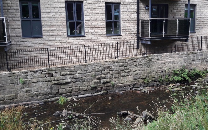
I was coming back from a visit to the supermarket the other day, and thought it would be a nice stroll, with James in the pram, to go along Glossop Brook and through Harehills Park up to the Market.
Now, if I may digress for a moment, despite the presence of a plaque, I steadfastly refuse to call this ‘The People’s Park’ which is an entirely new invention… and sounds absolutely awful. Even the name Harehills is of recent coinage, dating only from 1921 when the park was given to Glossop by Lord Howard to Glossop in memory of his son who was killed in the First Word War. Prior to that, the rough unused ground was known simply as the Sandhole – named, presumably, for the sand that was quarried here. Indeed, during the Cotton Famine (1861-65, caused by cotton no longer available from America due to the ongoing civil war there) Lord Howard employed the jobless mill workers in the area to dig sand – in essence giving them a paid ‘non-job’ so that they wouldn’t starve. He was alright, was that Lord Howard bloke! The area is still sandy, and indeed sand covers the footpath at one point along the way.
The location, on the brook, is lovely, and several developments have recently brightened up the area, including the redevelopment of the Old Glove Works on George Street (into flats, one assumes, but that is better than a derelict building). The new retirement flats just opposite the park itself went up surprisingly quickly, and look rather nice. However, if you poke your head over the side of the brook (carefully) you can see all sorts of history – dressed stone, drains, the old bridge, etc.
As I was pondering the detritus of history, I noticed a date stone had been cemented into the newly built wall adjoining the brook. Hmmm… I thought.
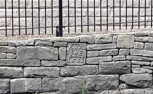
The date is 1681, refers to the date of the construction of the (now long gone) building to which the stone belonged, and the letters refer to the people who built it, usually a husband and wife. In this case, their initial would be, I assume, I (or J more likely) and E, and their surname began with H. This is important, as 1681 is a particularly early date for a building in Glossop – the Bulls Head pub in Old Glossop, usually reckoned to be the oldest building, has a date stone of 1607. I’m sure someone out three would be able to work out who they were and to what building the stone belonged, but it is beyond me I’m afraid. I am just glad that someone though enough about history to cement the stone the right way round in order to provide us with this little mystery.
As usual, any thoughts, comments, or general pointing and laughing, please drop me a line – email or comment below.

You have said HAT works, was it not a Glove Works as my grandmother worked there??
LikeLike
Hi David. Yes, quite correct… not sure how I mixed up hats and gloves. Just don’t ask me to fetch your coat!
LikeLike
Mike Brown of the Heritage Trust spoke to the builders about this after it appeared in the wall. They had found it in the rubble which had been used to fill the linear millpond of Shepley (Green Vale) Mill which ran across the site, and this may give a clue as to where it originated. The mill was demolished by Glossop Council in the late 1950s and the millpond was presumably filled in at around that time. During that period, the Council was engaged in a substantial amount of “slum clearance”, either of individual insanitary or unsafe buildings or whole blocks, as in the Kershaw Street/Freetown area of Whitfield, and it was common practice to pile the rubble into the nearest of the many disused millponds or goits, making them safe being another Council priority. This stone would have come from a fairly sizeable freestanding house, i.e something more than a mere cottage, and it might be possible to identify from maps buildings of that kind which were cleared in that period, although the period from the 1920s to the late 1960s is always problematic due to the lack of updating of the large-scale OS maps (which should have happened in the 1940s, but didn’t for obvious reasons). People who could afford datestones were also likely to make wills, and it might be possible to identify J and E.H from the Trust’s Wills and Inventories Database. However, John and Elizabeth Hadfield would account for about half the population in the early 1700s !
LikeLike
Hi Roger. Fascinating stuff. I have roughly looked at older maps, and nothing leaps out, but I agree that some hard work on wills and inventories would pay in identifying which particular Elizabeth and John Hadfield! It makes you think, what else is lurking at the bottom of abandoned mill races and ponds.
LikeLike
If memory serves as you went over the bridge from the Sandholes the mill was on the right – now demolished I believe as it’s a god number of years since I have been through there! This is your Glove works that saw a massive number of incarnations during my youth which included a searched covers firm run by Keith Blackburn at one point – a friend on my mum’s, we helped move his stuff out when he moved the firm up to the old paper mill on Turn Lee Road!
On the left was the old mill pond – as a nipper it was one of the places at the edge of my acceptable dolman when living on James Street 55yrs ago The spoil was crudely dumped there creating a area of little hillocks we would play, further down towards the road bridge over the river at the bottom of High Street West the pond was still full of water and not easy to get at some point I think a child either died or nearly died when I was around 6 or 7 and so the place became a no go area due to anxious parents. I think a boarded fence was erected to try and keep kids out which most likely failed, and it remained like that throughout my youth and until I moved away in the 80’s
I have no idea what the place is like now, but with the building craze just reaching unbelievable new highs since leaving I would imagine there are houses on it despite the fact that it was all prim flood area.
LikeLike