
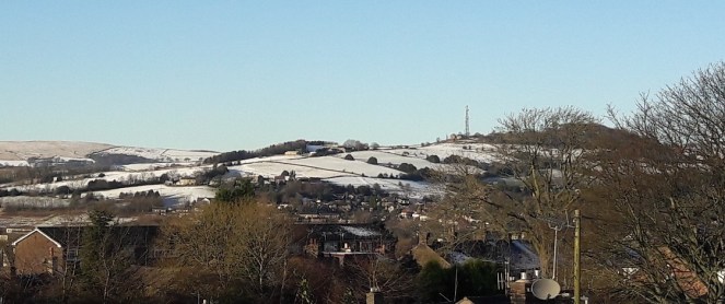
Wishing you all a very Merry Christmas, and here’s to a new Year filled with history and archaeology. To celebrate, enjoy a seasonal photograph of Mouselow taken from the SSE a few days ago.

Mouselow is an Iron Age hillfort, and a scheduled monument. It is also a hugely important part of Glossop’s history, and one that deserves a long post all to itself. This is just bit of Christmas fun.
In the photograph then. Just below and to the left of the antenna, you can see medieval ridge and furrow, a characteristic field mark derived from ploughing, highlighted in the snow. The snow, blowing in from one direction, sticks to one side of the ridge only, creating the stripes.
Also, just below that, it is possible to make out one of the massive ditches that would have surrounded the hillfort. Whether for defence, or for ritual reasons, to make the hill separate from the surrounding land, we don’t know. However, and whichever, Mouselow dominates the Glossop skyline.
Merry Christmas everyone.
Robert Hamnett.

The photo demonstrates the power of a thin coating of blown or melting snow to bring out the smallest of surface irregularities, which is why I’ve always tried to do fieldwork on cold clear days in February (low winter sun is also very effective !) The furrows in the lower of the two fields are visible on Google Earth, but not those in the upper field, and neither are visible looking down from the top, as you and I both know as we were doing that only a few weeks ago. I’ve just looked closely at a photo I took from there in March three years ago, when the grass was low, and I can see nothing at all. And there’s nothing either on the Lidar even though it’s supposed to pick up height differences of as little as 5 cm regardless of the grass (but often doesn’t, as I’m now beginning to realise).
However, I very much doubt whether they’re mediaeval, and I think they could be very recent. First of all, they’re obviously very minimal features, which could have been produced by various sorts of mechanised farming activity. Secondly, the top field in particular slopes away at greater than 1 in 4, and further east there are similar stripes visible on Google running across an even steeper slope. They could, in theory, have been ploughed but they would be “challenging” and there are much better places, and I think it’s more likely that at some point the farmer has run a heavy machine across them, possibly a flail mower to remove tussock grass or other unwanted vegetation. Google tells me the strips are 3.3 metres wide, which would fit with that.
Thirdly, they’re in an area which was almost certainly open common until the late C16th and probably a lot later, and at a distance from the two closest known mediaeval settlements, Higher Dinting and The Ashes, which were both very small and would have limited arable land concentrated close to the farms, with this land, on high and exposed ground, as pasture. Although I don’t think it applies here, what looks like ridge-and-furrow in odd places is, I suspect, often the result of cultivation for vegetables in the two World Wars – I’ve seen some evidence of it in Manor Park and it’s very obvious on Google in Bankswood Park, where it makes a very good sledging run !
There are, however, other ridges on the left of that photo which are much more mysterious….
Happy New Year !
LikeLike