
Found it!
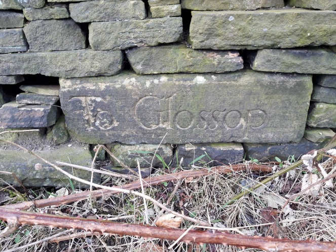
James, Mrs Hamnett, and myself went for a walk yesterday, taking advantage of the beautiful weather in the afternoon. Not a long hike – 2 year olds really don’t have a lot of stamina, and walk at a glacial pace, stopping to inspect stones, sticks, grass, puddles, clouds, etc. As we passed down the start of Carr House Lane, I looked to the left to see if I could see the guide stoop that I had been looking for since I first read ‘Glossop Remembered‘ by Neville Sharpe (highly recommended, by the way). A guide stoop is an early form of carved stone signpost, situated at road junctions, that tells you where each road goes; to use them, simply face the name of the location you want, and take the road to the right. They became common in the late 17th Century after a 1697 act of parliament, intended to improve road conditions, suggested that guide stoops were erected at junctions (There is a brilliant website about Derbyshire guide stoops here). In the book, there is a photo of a flat stone with the words ‘To Glossop’ inscribed rather ornately on the facing side. Stylistically, the date of the carving would be, I would suggest, sometime in the early 18th century.
Now, despite Sharpe telling us where it is, I have so far been unable to find it, despite trying dozens of times and in different seasons. I had begun to think that either it was firmly and permanently buried behind thick bramble and dog rose, or worse, that it had been removed and was now lost to us forever.
That is, until yesterday! Someone had attacked the bramble with secateurs, and lo and behold – the guide stoop was there!
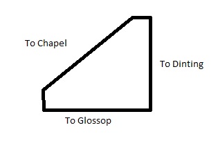
This was great news as it meant that we might have a chance to work out what the other three sides say, and thus where it was originally placed. There was some debate about location elsewhere on this site (in the comments, at the bottom here), but I was excited to be able to try and solve the problem. In short, we have a 4-sided guide stoop, with ‘To Glossop’ on one side, and, according to Sharpe, ‘To Dinting’ on another. It’s possible that Dinting is on the opposite side, but there is nowhere near that Dinting is in the opposite direction to Glossop. Plus, if we place Dinting somewhere else on the four sides, where are the other two locations mentioned? Chapel (en le Frith)? Sheffield? No, it is a bit of a mystery… until now!
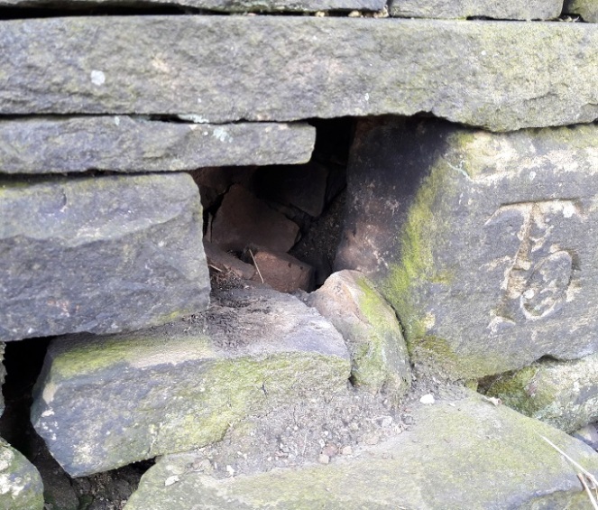
I felt along the right hand side, and with my fingers I traced an upper case ‘T’. Obviously, the start of ‘To’, but without dismantling the wall, there is no way of knowing to where. Tentatively, I removed some loose stones on the left hand side, hoping to push my hand in and be able to find the last letters of whatever place was written on that side of the square… and was shocked. It went back squarely for a few inches, and then turned abrubtly at 45 degrees. the stone was a triangle! Only three sides, and only three locations. I scrabbled my fingers along and traced a lower case ‘L’, but no more… The stone was too jammed in, and I couldn’t wriggle past it.
I might try again at a later date, but in any case, I think we now have enough to hazard a guess as to where the places are, and to where it was originally placed.
Glossop is obvious. Dinting is likely – we have no reason to doubt Sharpe, although I don’t know how he knew that. The last… well, we know it ends in an ‘L’, so it is probably Chapel (en le Frith) – although Mrs Hamnett suggests, not unreasonably, Chunal.
This is my reconstruction of the guide stoop’s inscriptions and shape.
So where, if this is the configuration, did it stand? Well, simply and almost certainly, at the top end of Whitfield Cross, where it meets Hague Street/Cliffe Road.
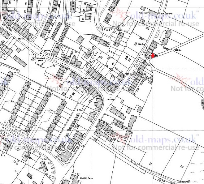
If this is the case, the ‘Glossop’ side would be facing south east, indicating Glossop is down Cliffe Road. Dinting is north east, accessed via Whitfield Cross, Freetown, and then Hollin Cross Lane (the old Roman road). Chapel (or Chunal) is facing south west, and accessed via the road down to Gnat Hole and then onto Chunal, Hayfield, and beyond.
The only way we would know for certain is to demolish the wall… and that would be a massive undertaking.
Just as with the Whitfield Cross, I would love to see the guide stoop restored to its place of origin – I think it would look amazing at the junction, perhaps on the pavement at the left. We really could turn Whitfield into a heritage hotspot.
As an amazing bonus, on the way back, and just by Whitfield Cross, I found this.

Just peeking out of the soil, I thought it was a stone at first – it’s perfectly spherical and very tactile; a child’s toy marble. It’s stone – marble or alabaster I think, but certainly not clay as most of the Victorian marbles are, and because of this, it clearly belonged to a well off child. I wonder if it was lost on the path, or if it was lost in the city and ended up in the field as part of the process of night soiling?
Either way, it’s a hell of a find. It’s so personal and intimate – and this is why I love doing what I do.
Please feel free to comment, correct, or just chat. All is welcome.
RH

Get permission to demolish the wall. It needs to be seen and preserved. Give Whitfield a much needed break 😂
LikeLike
I have been along there recently and can no longer see the stone, it was clearly visible before. Has the wall been demolished and a timber fence put up do we know?
LikeLike