If you follow me on Twitter, you might know that I recently gave a talk to the Macclesfield LIT Festival with the wonderful Elizabeth Garner. It was billed as an evening of folklore and folk belief, with Liz reading folk tales from her new book, and me discussing all manner of magical things designed to protect against witchcraft. Well, it was a great event (thanks to all involved), and I think quite successful judging from the reactions.
Well, if you missed the live event (streamed from my spare room), it’s now on Youtube. We explore some interesting local archaeology, look at witchcraft and counter-witchcraft measures, and hear some great stories. Enjoy (video starts at 4 minutes).
Please also feel free to follow me on Twitter – I tweet fairly frequently about local, and occasionally not so local, interesting archaeology/history. And there is absolutely no politics, guaranteed. @roberthamnett if you want to follow me.
An interesting title, and a tantalising tale, today. I was originally going to post today’s topic at the end of the Lean Town posts (here and here), but after they became too large I thought I’d do it as a separate post.
Reading through Hamnett the other day, I came across this:
“The Gnat Hole Wood is very pleasant in the Summer time when there are no gnats about. The small stream of water that runs through the wood at one place forms a small pool; this was known as Old Nat Nutter’s Porridge Kettle. She had the reputation of being a witch and fortune teller and used this pool for unholy practices and incantations. She was a bogey to children.”
Interesting… I do love a good folk story, and one with tantalising clues, too.
So off I buggered (in those happy-go-lucky pre-covid times, when one could just bugger off into the woods) to look for the Porridge Kettle, and any signs of Nat Nutter.
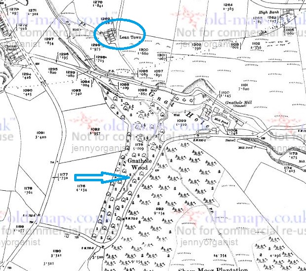
The stream referred to is, presumably, the one pointed to by the large blue arrow in the map below, as it is the only one to run through Gnat Hole Wood (or Gnat Hole Plantation, as the earlier maps name it).
The map of the area. For reference, Lean Town is circled in blue.
As far as I can tell, it is unnamed. I’m sure it had a name at some stage in its history, as watercourses are one of those landscape features that no matter how small – and this one is less than a mile long – are given a name, even if only a local one. However, we must remember that the surveyors who actually drew the maps, whilst superhuman, were not invincible – they might have had an off day, or it might have been raining and they didn’t fancy getting wet, or there was no one around to ask the name of that particular stream, or… you get the idea. Moreover, the fact that Hamnett himself didn’t know the name, particularly given his uncanny ability to “know things”, seems to indicate that the name was lost by 1910 (when the article was written), and probably a good deal earlier. The brook itself begins on, and is formed largely from the water run off from, Shaw Moor (perhaps we should call it Shaw Moor Brook) and it joins Bray Clough Brook between Gnat Hole Mill and Lean Town.
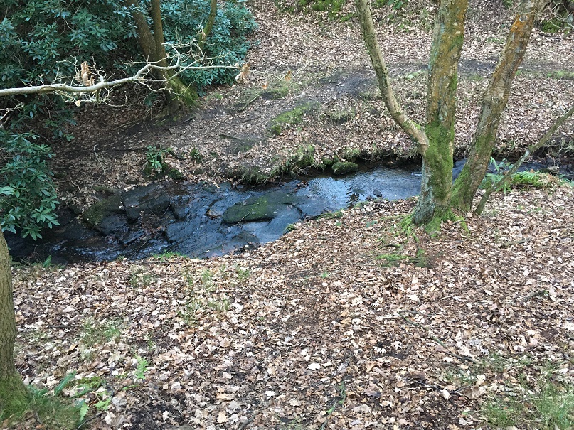
I travelled through the woods here, looking for a “pool”, or something that might match the description:
This is the upper part, with Bray Clough Brook below.
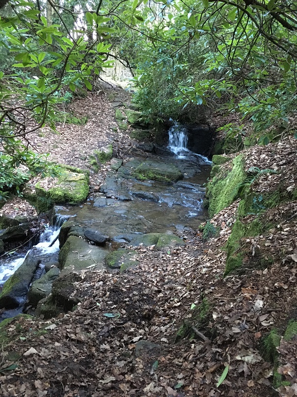
Here it drops into a series of waterfalls, in a steep secluded glade. Atmospheric to be sure, and perhaps a perfect place for witchcraft.
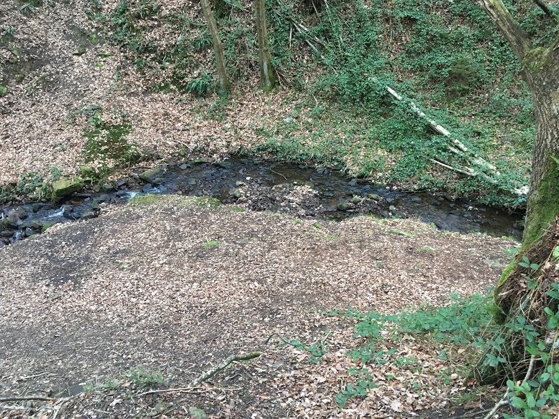
Lower down, and more open, but still steep sided
Alas, I found nothing that would definitely be called a pool as such, nor anything that could be connected to Nat Nutter. The area must have changed a huge amount since 1910, and even more so since the ‘witch’ was supposedly living there (early 19th century, perhaps earlier?), so it’s not surprising. Disappointing, but there you go.
So who was this Nat Nutter? Well, the description of her as “a witch and fortune teller” suggests that she was what is known as a ‘wise woman’ or ‘cunning woman‘ – a sort of combination of healer, folk magician, and someone who divines for fortune or lost objects. A particularly important function they performed was the production of spells and magically protective charms, as well as being a first port of call for medical matters, especially those involving pregnancy and abortion. They were common from the medieval period until the early part of the 20th century.
Whoever she was in reality, she was still remembered by 1910. Her name, though. Well, her name is suspicious, and is perhaps a construction – Nat Nutter, living in Gnat Hole Wood? Hmmmm. Also, the Nutter part recalls Alice Nutter, the Pendle Witch executed in 1612. It all seems a little too good to be true! But perhaps this was deliberate, the name adding to the mysterious otherness of the scary woman who lived in the woods by a stream that she used as a witch’s cauldron.
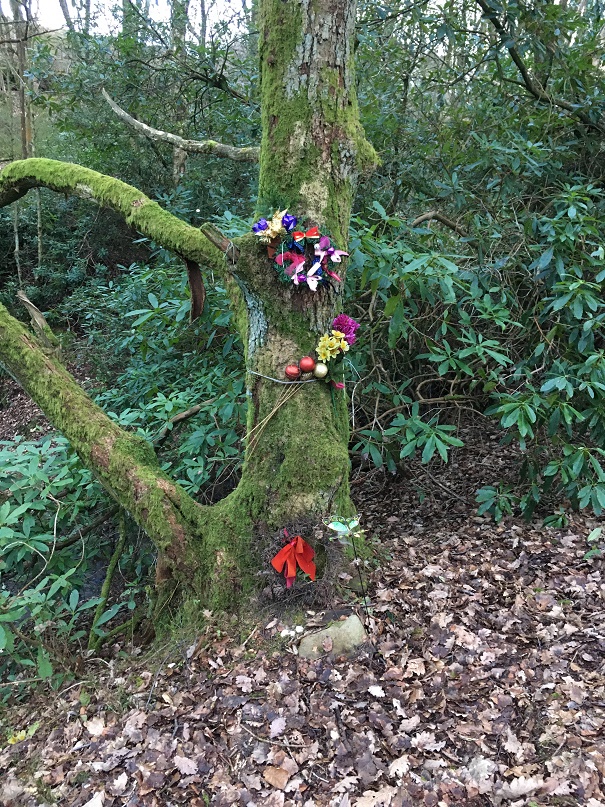
The old ways are not too dead – this tree is overlooking the brook.
Marvellous stuff.
Please feel free to comment, even if just to tell me that you are related to Nat Nutter, and that I have libelled her.
Stay safe, and look after yourselves and each other. More to follow soon(ish).
Happy New Year, dear and gentle readers. The first post of a new decade is just a quick one to fill in the gap whilst I finish a much longer post on the subject of Lean Town… all will be revealed soon.
So, a few months back I blogged about some postcards I bought on Ebay, and one in particular really caught my attention. The blog post is here, if you want to refresh your memories, and this is the postcard that piqued my interest, and made me buy them from a chap in America:
Top oth’ Nab, Glossop, October 21st 1907.
I love a good ghost story – one of my absolute pleasures is reading MR James stories by the fire – so the writing on the card that read “this is the haunted house” sealed the deal of me buying the cards. In the original post I though that the hunted house might be Herod Farm.
Roll on New Year’s Day 2020, and slightly bleary eyed and thick-headedly (courtesy of the Goosefields – thanks again!), Clans Hamnett and Bowes ascended Whitley Nab from The Hare and Hounds. It blew the cobwebs away (and if I’m honest, knackered me out – new year’s resolution is to get fitter), but we made it – and this is the site that greeted me.
Top oth’ Nab, Glossop, January 1st 2020.
It looked familiar. And then it hit me… the ridgeline of Coombes Edge, and the skyline… this was the haunted house photograph. The haunted house was, in fact, Herod Edge Farm, just off Monk’s Road – visible, just, in the trees, middle ground. Here’s a map.
Herod Edge Farm is circled in red, my photograph was taken from the area of the green arrow, the original photograph was taken from the blue arrow, or thereabouts.
Compare the two photographs, and although it’s taken from a slightly different angle, there are so many features in common that I can say with certainty that this is the place. Herod Edge Farm is haunted… apparently. I wonder if they know? And more importantly, does anyone know the story of the haunting? I wonder if it is tied up with alleged ghostly Roman soldiers in the area? Someone must know – as I say, I love a good ghost story.
I should add that, since that post, a whole pile of information has been uncovered, largely by the ever helpful Charles Wynford Lodge (who is on twitter as @2hrTV, check him out). I will do a full re-write including all his information, as well as corrections and addenda on other previous posts, too. See, I do listen… honest!
In the meantime, I’m off to drink some of the stuff that nourishes and try and finish some other exciting work (oddly, involving a parrot and the High Medieval period… no, it’s not a set up for a joke). Oh, and the Lean Town post will be up and running very soon (it’s a two-parter!).
What ho! What ho! What ho! and all that (raising a glass to you, H & S).
I often spend a bit of time on the internet, and in particular on ebay, looking at all sorts of Glossop and area related things and obscurities. In between wishing I had more money (all donations will be gratefully received) and marvelling at just what people on ebay are trying to sell (and, by extension, what crap people are willing to buy) I occasionally come across an interesting object. Postcards are only interesting if the subject is interesting, but usually I just save a copy of the picture and move on. However, I found a group of four postcards of the “High Peak, Derbyshire, UK” mentioning Glossop, being sold by a chap in America which piqued my interest. Although there was nothing particularly special about the subjects – nice photographs though they are – I was intrigued by the writing on two of them.
First, the ‘boring’ postcards.
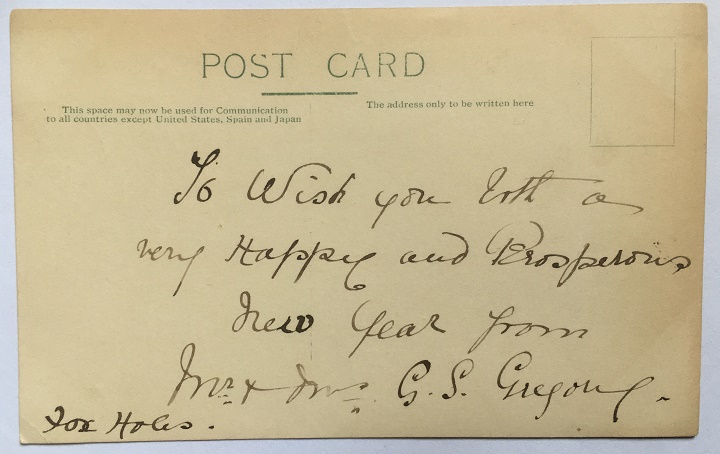
The first is titled “Chinley, from Eccles Pike No.2”, and shows exactly what it says.
The postcard hasn’t been posted, so there is no stamp or postmark, and was probably inserted with a letter, and the whole posted. The message on the back reads: “To wish you both a very happy and prosperous new year from Mr and Mrs G.S. Gregory, Fox Holes”. Foxholes is in an area of Chinley called Whitehough, which fits the postcard view.
Next up is this view of the North Road entrance to Howard Park, or “Park. Top Entrance” as it is helpfully titled.
Park keeper’s cottage, Howard Park.
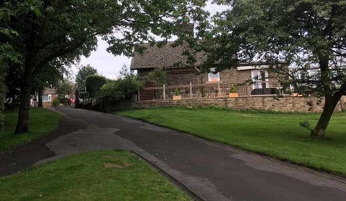
The building and gates are still there, as you can see in this modern view of the place.
Surprisingly, very little has changed in the 100 years.
The back of the card, then.
Mrs Broadbottom (I think) and Miss Woods, helpfully written in thick pen and at a jaunty angle
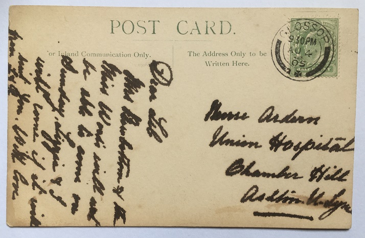
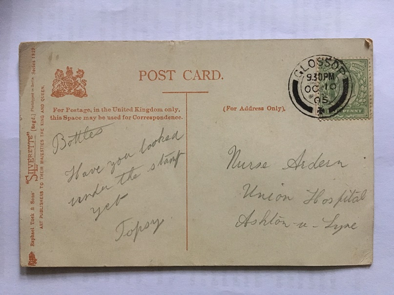
It has been posted, and stamped “Glossop” (Glossop post office) and dated August 4th 1905, and was for the 9.30 post. The message reads “Dear Lib. Mrs Broadbottom (?) and Miss Woods will not be able to come on Sunday. Lizzie and I will come if it will suit you. With love from L & R.” One hopes that Lizzie and ‘I’ were a suitable replacement for what was clearly a comedy double act of Mrs Broadbottom and Miss Woods… but alas, we’ll never know. The address, however, is interesting:
Nurse Ardern, Union Hospital, Chamber Hill, Ashton Under Lyne
Frustratingly, I can’t find a Nurse Lib (Elizabeth?) Ardern in the 1901 or 1911 censuses, nor anywhere else I have looked (please feel free to have a look yourselves), but it is interesting. The Union Hospital is actually the Workhouse in Ashton, and the building is now part of Tameside General Hospital. Here is a view of the Hospital in 1905, the same date as the postcard – perhaps Nurse Ardern is one of the ladies in the photograph.
The Ashton Union Workhouse in 1905.
The above photograph was taken from a very informative website that gives the history of the Ashton Union Workhouse – go check it out here.
Now, the first of the interesting postcards, and one that contained a mystery! “Oooooooh” I hear you cry…
The view is of Howard Park again – this time the swimming baths and that end of the park. The view has not massively changed, as the lower photograph shows.
Howard Park and the swimming baths, chimney, and Wood’s monument, all built by the Wood family in the late 1880’s.
Almost the same view, today. Too many trees to get the exact shot, but you can just make out the chimney, the white ornamental windows of the baths, and the base of the Wood’s statue.
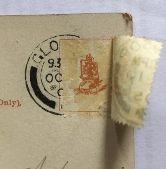
Now, the mystery. The card is once again addressed to Nurse Ardern at the Union Hospital. It is marked and dated Glossop, October 10th 1905, and stamped for the 9.30pm post. The inscription is simple: “Bottles. Have you looked under the stamp yet. Topsy”. It sounds like a letter from a PG Wodehouse novel (are Bottles and Topsy members of the Drones Club?). Bottles must be a pet name for Nurse Ardern, and Topsy? Who knows? A suitor? A brother? There is a familiarity about it that suggests either. But what’s this about a stamp? I looked, and no, the stamp had not been tampered with; Bottles had evidently not looked under it.
To Bottles, from Topsy… via Jeeves and Wooster.
With slight fear and trepidation, I made a cup of tea, and using the steam from the kettle, I steamed off the stamp. What was under it? A heart? A love note? A secret spy code? A crude drawing of some male genitalia? (the heady days of early Edwardian Britain saw society throw off the shackles of Victorian prudishness, so who knows?). Carefully, I peeled back the stamp, and this is what I saw:
Ladies and gentlemen, the comedy styling of Topsy.
It is just the card maker’s mark (Raphael Tuck and Sons), and nothing remotely interesting. Bugger! Two possibilities suggest themselves here:
Topsy has a particularly weak sense of humour, and the ‘joke’ is that there is nothing under the stamp (oh, my sides. Nurse, the screens… etc. that last being especially appropriate). No, even a badly drawn willy would have been funnier.
The postcard is referring to another postcard or letter, and Topsy is reminding Bottles to look under its stamp.
Either way, I was as disappointed as you probably are right now.
This last postcard is not disappointing, though, and should make up for the above.
We’ll start with the back – and a particularly interesting one it is.
A letter to America all the way from Glossop.
It is addressed to a Mr J S Crowther, 506 Greene Avenue, Brooklyn, New York, USA. It is postmarked Glossop, and dated Oct 21 1907, and stamped for the 7.30pm post. It is counterstamped ‘Brooklyn, NY’ with a date of October 30th 1907, and time stamped 8pm. This is presumably the time and date that the postcard landed in the USA – nine days to cross the Atlantic is quite impressive. There is nothing else written on the back, and the identity of Mr Crowther remains a mystery (as does his relationship with the postcard’s subject, as we shall see). His house in Brooklyn is still standing, though:
506 Greene Avenue, Brooklyn, New York, at the end of the row.
Right then, the subject of the postcard, and the reason I bought the quartet of postcards in the first place:
I love this sort of thing – when history and folklore collide.
The subject is “Top oth’ Nab, Glossop”. Whitley Nab, of course, and you can indeed see the top in this quite atmospheric photograph. And in the mid ground, to the right, there is a building amidst a series of field walls. It is a good photograph anyway, but what drew me to it was the handwritten note at the top:
“This is the haunted house. Oct 21st ’07. T. Arden”
I do love a good spooky story.
I’m not a big believer in the supernatural, but I am a lover of folklore and of ghost stories, and I knew I had to have it!
Well, where to start? I have looked at contemporary OS maps of the Nab, and am almost certain that the photograph is of Herod Farm; the location and the field boundaries all seem to make sense
If anyone wants to double check, please mail me if I’m incorrect
I find it interesting that Mr Crowther knew the area well enough that he didn’t need any further explanation of either the place, or the haunted house and its story. He must have been an emigre to the States from Glossop. The handwritten note is signed T. Arden – is this ‘Toppy’? And there is surely a relationship to the Nurse Arden, too – the coincidence of the name is too much. And how did they all end up in the America? Did Nurse Arden retire to the States? I would love to know the answers to these questions – any thoughts, anyone? But more importantly, what is the ghost story attached to Herod Farm? Does anyone know?
If you do, please let me know via email or twitter. Or, for that matter, any other ghost story or note of folklore you know about the Glossop area – I’ll happily take what I can! Just get in touch!
Anyway, I hope you enjoyed a wander round some old photographs. I’ll post an update if anything come from this post. Until then, I remain,
Placenames in the past were given because of what was there, not aspirational or deliberately flowery. They were practical. Descriptive. Truthful. There was no Laurel View if there was no view of laurels. Gnat Hole was not named ironically. And Shittern Clough was… well, you get the picture.
For me, Gallowsclough has always stood out in the map of the area – the clough, or narrow valley, where the gallows were. There is something of the macabre about the name, and I was also aware of a folktale from the area which really made an impression on me (more of that in a bit). So I decided to do some exploring, to see if I could add to the placename, and see if I could work out where the gallows were… as Mrs Hamnett put it “lucky me, you take me to the loveliest places”.
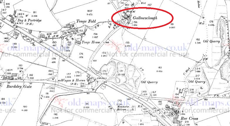
I’ve blogged about this area before (White Stone of Roe Cross), but the area is effectively the Deep Cutting between Mottram and Stalybridge. Gallowsclough is highlighted (the clough itself, or small deep valley, running towards the Dog and Partridge).
Gallowsclough and area. This from the 1898 1:2500 OS map (via the awesome oldmaps.co.uk). The main road to Stalybridge from Mottram runs diagonally through the map, with the deep cutting starting at the Wagon and horses.
So then, the gallows.
The last person to be hanged in public was in 1868, after which time, and until capital punishment was abolished in 1965, executions took place within the prison, away from the public eye. But before 1868 it was a public spectacle, to the point that the hangings at Tyburn were turned into a public holiday. Often associated with the public hangings of the 17th and 18th centuries was the punishment of gibbeting, in which the hanged criminal was enclosed in a tight fitting cage or chains, and effectively left to rot. The body was covered in tar in order to protect it against the elements, and hung there as a warning to others until it finally fell to pieces.
Each area, feudal estate, or manor had a gallows/gibbet, and certainly until the later Tudor period or even the early modern period, capital punishment was the responsibility of the lord or equivalent. It seems that the victims were buried underneath, or nearby, the gallows, but certainly not on consecrated ground. To be executed was to be condemned to eternal restlessness, to never know peace, and to wander the Earth an unhappy spirit.
In order to achieve maximum visual impact, the gallows were normally set up at prominent places – central open spaces, or more normally, crossroads. And so it was here, in Roe Cross. The body swinging, both at execution, and in a gibbet, could be seen easily by both locals, and by travellers moving along the various roads – a physical reminder to obey the laws, or suffer the consequence. Interestingly, this tradition of both execution and burial at a crossroads has given rise to the concept that a crossroads is an odd, supernatural, place. If you want to sell your soul to the devil, where do you do it? Where do you bury witches? Or suicides? Or criminals? At the crossroads, that’s where.
So where were the gallows at Gallowsclough? It is very doubtful that they would have placed them further up the clough – difficult to get to, in arable land, and there are no crossroads. No, I think they erected the gallows at the point Gallowsclough – the clough, or deep valley, upon which the gallows are placed – crosses the road. At almost exactly the point seven – count them – seven tracks join. This is no crossroads… this is a crossroads and a half. Here is a map showing the tracks (numbered).
The seven tracks shown on the map existed before both the turnpike road and the ‘Deep Cutting’ were made. Walking them, you can see why the turnpike was created. It is still perfectly possible to travel to and from places on these tracks, but perhaps don’t if you don’t have a 4×4.
This is the area close up – you can see the tracks meeting.
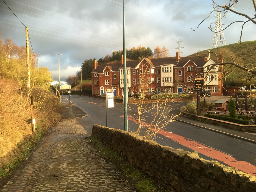
Right by the Wagon and Horses… enjoy your pint!
This is the site. You can see the roads meeting, and here at the bottom of Gallowsclough Road, you can see the setts of the original track, laid to give horses some traction at the start of the hill.
The roads are as follows (the numbers are faint in blue in the map above):
Gallowsclough Road – From Saddleworth, via Millbrook (avoiding Stalybridge). This is the Roman Road between Castleshaw Roman fort and Melandra (thanks Paul B.)
From… well, the middle of nowhere – local traffic from farms
From Hollingworth.
From Mottram via the old road.
From Hattersley, via Harrop Edge.
From Newton.
From Stalybridge, via the old road.
A perfect situation for an execution and gibbet. It was said that it was to these gallows that Ralph de Ashton (1421 – 1486) sent the unfortunate tenant farmers who couldn’t pay the fines for allowing Corn Marigold to grow amongst their crops. The death of the hated Ralph is the origin of the Riding the Black Lad custom and the Black Knight Pageant in Ashton Under Lyne, a tradition sadly no longer undertaken. Naturally, the area is said to be haunted, with the locals avoiding the place, even in daytime. Although, as is so often the case, there are no references, only suggestions.
This is the clough
The brook flows under Gallowsclough Farm.
Gallowsclough in the background, behind Gallows Clough Farm. The electricity pylons completely ruin the area, unfortunately.
Of course, whilst I was stomping around, I happened upon a bunch of mole hills…
Evidence of nightsoiling (as I’m sure you all know, having read previous posts about this). The top row right: a medium bone china plate (c.18cm in diameter), hand painted flowers and abstract floral designs in pastel colours. This is quite nice, and is probably early Victorian in date. Middle is a plain white glazed plate, thin, and again about 18cm in base diameter (you can see the ring of the base in the photo), which makes it perhaps 24cm or more in ‘real’ diameter. Left is more difficult – it has an undulating rim, with a curled decorative motif – which means that I can’t tell you how big it is. Over 25cm in diameter, I suspect. It is a shallow dish, or deep plate, and is deocrated with abstract floral designs. Date wise? Late Victorian? Looks more modern than that, though… Edwardian? The bottom four are fairly boring body sherds, though the sherd on the left is a blurred willow pattern, so potentially quite early?
Contents of a Molehill, pt. II
The ubiquitous lump of coal/coke to the right, and the ubiquitous clay pipe to the left. The lower of the pipes is nice as it still has the spur that juts out and forms the base of the bowl, which you can see just emerging. It’s probably early to mid-Victorian in date. -Check out this wonderful website for more information.
The spurred type of pipe is middle right.
And finally, to end on, this lovely thing.
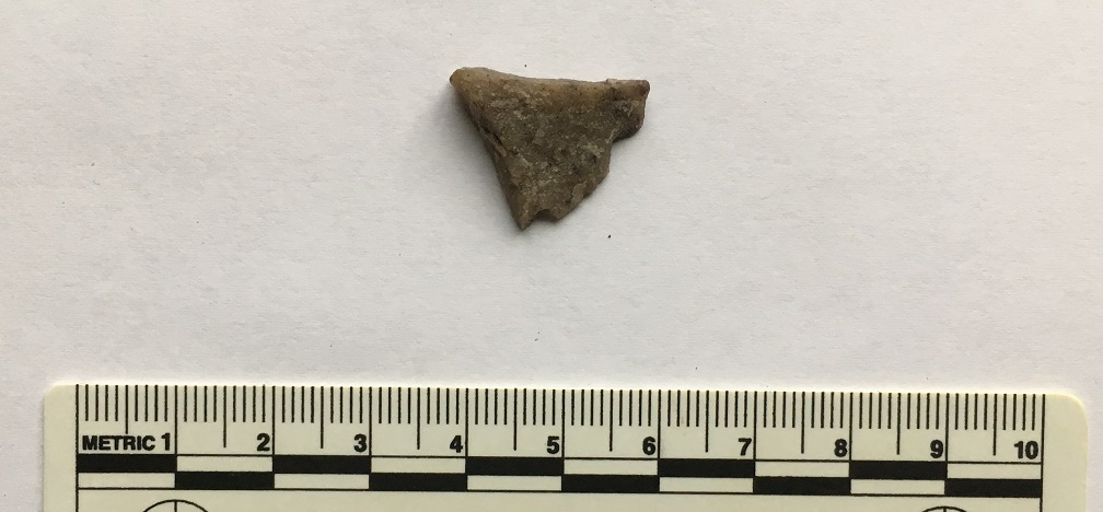
Ding dong, the Mesolithic calling.
A flake of quartzite that has been struck in prehistory, during the course of making a tool. Flint doesn’t occur naturally in this area, so all sorts of stones were used in the making of stone tools in prehistory. Quartz, though a poor cousin of flint, still keeps enough of an edge to be useful, and this piece carries all of the hallmarks of a bit chipped off a larger tool or weapon – the striking platform (top), and the bulb of percussion (facing, half way down). I suspect that this is Mesolithic in date, so c.6000 – 4000 bc, or thereabouts. I’ll post some more flint/chert/quartzite when I get a chance, as it’s fascinating stuff, and the area is not exactly lacking in it.
*
Interestingly, there is a brewery marked on the map (top left, numbered 8). This is the Matley Spring Brewery, which brewed beer here, using the local spring for water, and presumably selling it in the Dog and Partridge, at the end of the wonderfuly named Blundering Lane. I was going to write a little about it, but came across this site with some information and photographs. Actually, the whole blog is a good read, filled with fascinating titbits relating to the area, so go forth and explore.
*
And finally, as promised, I’ll end with the folk story of Gallowsclough. This is taken from Thomas Middleton’s Legends of Longdendale (the book is a mine of local legends and folktales, as well as some good photographs, and is well worth seeking out – or reading in the pdf format at the link below)
It’s very Victorian in its telling, but the story is as black and evil as any I have read; there is something about it that disturbs and lingers in the mind – the imagery, and particularly the witch walking away at the end. No, I like a good dark folktale, but this is just on the border of being a little too dark for my tastes. Enjoy at night, and you have been warned…
So there you go. There’s plenty more in the pipeline, so watch this space. As always, comments are very welcome, and all will be published.