Mottram · Placenames · Simmondley

Vikings? In Simmondley? Hwaet? (Dark Age Glossop Part 1)

What ho, people, what ho! I hope you are all well and are suitably recovered after the Christmas season?

A word heavy – and pottery light – blog post today (those of you cheering at the back… don’t think I can’t hear you). It’s also a little speculative, too. Archaeology, and indeed history, rely on interpretation, and how we understand and use the evidence presented to us affects the story we tell. We don’t always have all the answers, and we do make mistakes, but speculation is essential, so let’s imagine… today’s story is of Anglo-Saxon Glossop, so buckle up!

Now, I love a good placename or two. Ask anyone who knows me and they’ll say “Oh yes, old TCG loves a good placename or two. He really loves them”. And then they’ll give a look. That look. I’ve never worked out what it means, that look, but shortly after the person who asked will give a nod of recognition, and say something along the lines of “… oh! I see!” And then both will turn to me, cock their heads and smile kindly, and give me an entirely different look, one of benevolence and calmness, that seems to say “awww, bless you“. Worryingly, I often get the same look from Mrs CG and Master CG. Anyway, moving swiftly on.

So then, Glossop in the Anglo-Saxon period; the Dark Ages, so-called due to the lack of historical knowledge. This is, truthfully, something of a misnomer, and our understanding of the turbulent period of 600 years between the Romans ‘leaving’ (410AD) and the Norman Invasion (1066) is becoming clearer all the time… mostly. For our own area, though, it is still by and large a black hole of historical detail. We know something was here during this time – we have Roman (certainly early Roman), and it’s highly unlikely that the military abandonment of Melandra (probably later 2nd century AD) meant that everyone left the area, especially given the location at the head of the Longdendale Valley. The Domesday survey of 1086AD lists 10 villages hereabouts, so there is definitely something here 600 years later that didn’t just spring into being overnight.

Phil Sidebottom has recently written an excellent book called ‘Pecsaetna‘ (and do feel free to order from our marvellous local bookstore – Dark Peak Books) which looks at the Anglo-Saxon tribal grouping that lived in this area – the Pecsaetna, or ‘Peak Sitters’ – of which we Glossopians should rightfully be proud to be a member of. It doesn’t cover Glossop as such – we are very much on the periphery of what was already a backwoods – but it is a great read for anyone who is interested in what was going on in the Peak District during this period. But the fact of the matter is that there is very little archaeology to be found relating to these 600 or so years; to be precise: 3 stone crosses (the 10th century Mercian Round Shafts – Whitfield Cross and Robin Hood’s Picking Rods), and placenames. That’s it. We don’t even have any pottery to look at, as it seems that in this area people were largely a-ceramic – that is, they simply didn’t use pottery. Imagine, a world without pottery… now that’s a sobering thought.

Some of the placenames in the area I have covered before (the main Domesday ones, for example), but some others I haven’t, and in particular, Mottram (in Longdendale), I find particularly interesting. It is probably derived from (ge)mot (a meeting or assembly) and either ‘treum‘ (tree or cross) or ‘trum‘ (a place or space). Either way, it is almost certain it describes a place where meetings took place, marked possibly by a tree or a cross. These meeting places – or ‘moots’ – have been described as the “cornerstone of Anglo-Saxon governance”, in that various Anglo-Saxon statutes dictated that these councils met publicly every four weeks at these moots to discuss local matters – think of them as local councils and magistrates. They are important places, often marked by a prominent feature – often a cross or a tree – and were in an elevated position – a hill, or lower slope, overlooking much of the land. The one at Mottram fits the bill perfectly, and it was possibly the extreme north eastern moot place of the pre-conquest Hamestan Hundred, right on the border of the land (the River Etherow). All very intriguing stuff, and has relevance for Part 2 of this Dark Age speculation – coming soon.

However, one small group of placenames got me thinking recently, and these are those that have a Scandinavian origin, and by Scandinavian I mean, essentially, Viking.

Soooo… Clan CG went on a week-long jaunt in Norway last summer. And wow, what a country! Beautiful, full of life and history, nature and culture… there is something about Scandinavia that really appeals to me. And at every stop (we hired a campervan) there was wild swimming. Marvellous stuff – the clean water of the fjords; fresh, invigorating, life affirming, health giving. I mean to say, not for me, obviously! I dipped a toe or two in… but brrr – far too cold! So I stayed on the bank and cheered on Master and Mrs CG, who seemed to enjoy it!

One of the places we visited was Trondheim, a lovely town right at the top of an enormous Fjord, next to an an enormous mountain; scale is a thing in Norway, and I’m sure these landmarks would be puddle and hillock respectively to the locals. We parked up a hill out of town and walked in, and as we approached a crossroads, my sherdy-sense tingled. No, not sherdy-sense, something else. And then I saw it… the road names. We were walking down “Langes Gate“, and we had just crossed “Storgata“, and before I knew what was afoot, my brain had forced out a mighty “what ho!” which might have alarmed the natives somewhat.

Langes Gate (Long Street), Trondheim, Norway.
Storgata (Big Street), Trondheim, Norway.

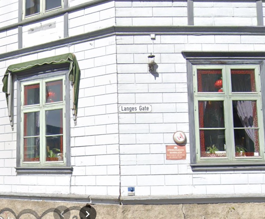
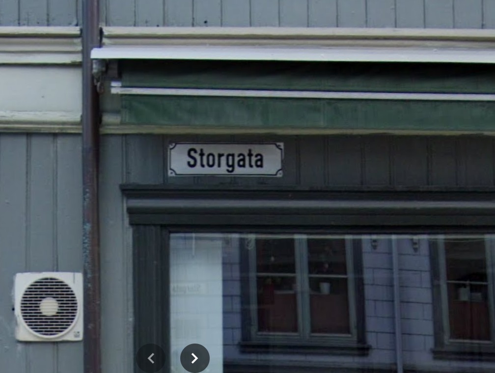
I recognised the word ‘gate‘ or ‘gata‘ from British placenames. Scandinavian in origin, meaning street or road, locally it can be found in Doctors Gate and Redgate, and this reminded me of a pet theory of mine, and I began to hastily scribble words down back in the campervan that evening, a glass of stuff that (expensively) cheers clasped firmly in hand.

Of those Domesday placenames I looked at, one really stuck in my mind, niggling with possibility. Truthfully, sometimes these things do, and I don’t know why; they shimmer and make a noise in my head, drawing attention to themselves more than others – I assume it’s my brain making connections, rather than an objective noise, but you never know… and once again, I feel I have overshared!)

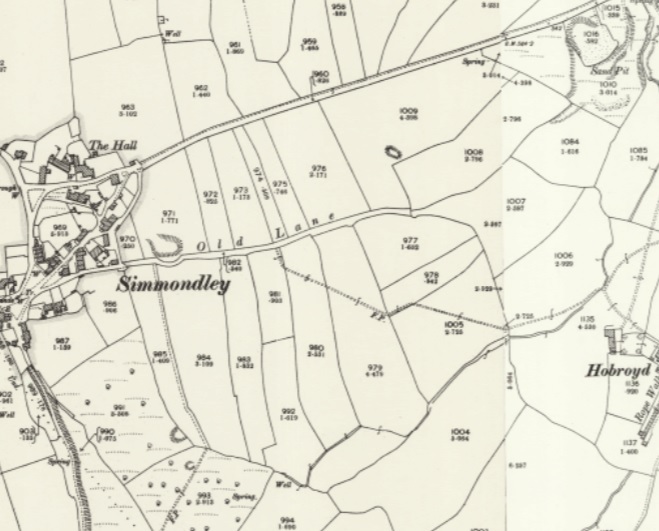
Simmondley. First mentioned in the Forest Proceedings of 1285 as ‘Simundesleg‘, and then later as Simondeslee, the origin of the name is “the clearing (or ley/legh) in the forest belonging to a man named Sigemund (Old English) or Sigmundr (Scandinavian [Viking]): Simmondley. Ok then, so we have a possible ‘Viking’ name, but there is no evidence for Vikings hereabouts. Or is there? And this is where is started to get interesting.

The Vikings – and all manner of Scandinavian folk – first began raiding the coastlines of England en masse at the start of the 9th century. Eventually, the raiding stopped, and it became a steady flow of immigration, settlement, and farming – swords to ploughshares, and all that. It’s a big country, there was a lot of land, and so they stuck around, and in doing so they changed not only the language we use, but also the placenames of the area they settled – in particular, the area that became known as Danelaw – where they were allowed to keep following their own laws as long as they were loyal to English (Saxon) kings. The exact limits of Danelaw is a bit of an unknown, but it roughly stretched from Essex to Northumbria, and across to the Mersey – this is lifted from the Wikipedia page, and Danelaw is in red.

As you can see, whilst we are on the border, we Peak Sitters are still within Anglo Saxon (English) controlled lands, hence we don’t have many Scandinavian placename elements hereabouts, those name endings such as –thorpeholme, –by, and -ton that are common enough just over in West Yorkshire, but not at all here. It has been suggested that the limit of Danelaw, whilst flexible, may have been the River Etherow and Derwent Valley, making us very much at the limit of Saxon land (If you are really interested, the always excellent before1066 blog has a great read about the Danelaw in our part of the world – you can read it here). But this area is firmly Saxon in language, and thus in placename.

Or so it seemed… and here it gets speculative.

Whilst the area was never settled properly, Sidebottom notes that a small number of areas in the Peak District have Norse derived placenames in their landscape, perhaps indicating the presence of settlers (Monyash, for example). These, he suggests, are Hiberno-Norse settlers – in essence, Vikings who had settled in Ireland, but were expelled from there in the early 10th century and settled in the area around Chester and the Wirral. From here, they moved east and were allowed land to the east of Manchester, specifically in the marginal western slopes of the Pennines. Hmmm… east of Manchester, in the slopes of the Pennines…. does that description sound familiar? Yeah, it rang a bell with me.

These were not true Vikings, and were actually 2nd or 3rd generation immigrants, but they would have spoken their language, and whilst they might not have named any existing settlements as such, they used their dialect words to name the elements of the landscape, and these don’t often change.

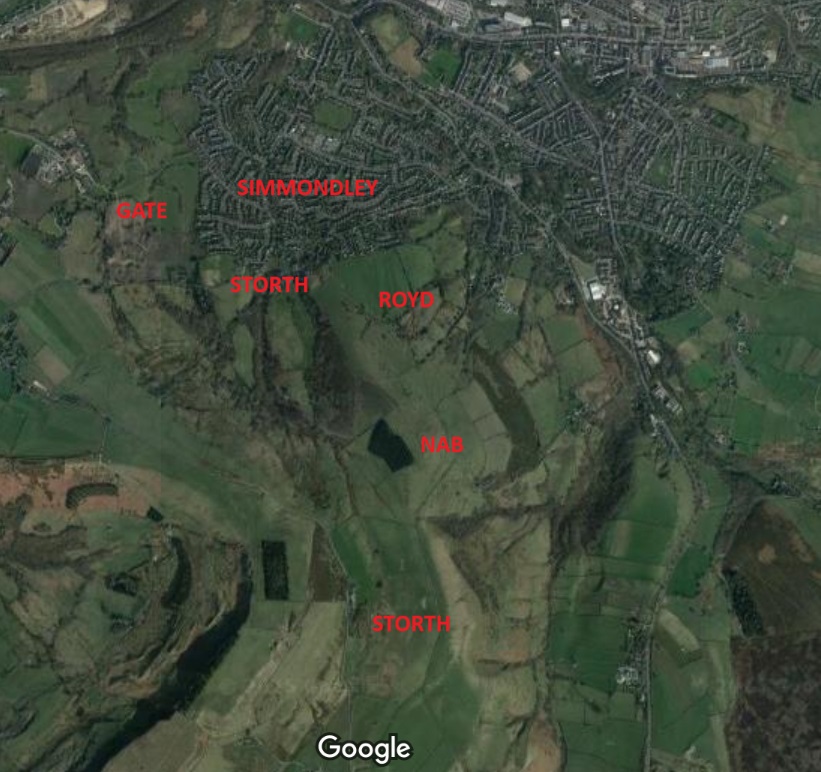
It was the origin of the placename Simmondley that initially rang the bell of possibility. It is first mentioned in the Forest Proceedings of 1285 as ‘Simundesleg‘, and then later as Simondeslee. The meaning of the name is “the clearing (or ley/legh) in the forest belonging to a man named Sigemund (an Old English name) or Sigmundr (a Norse name): Sigemund’s Legh = Simmondley. We assume it’s Saxon, because there are no Norsemen around here… but what if there were? And then the second bell was rung in Trondheim… Gate. In the Simmondley area, this is found as part of Hargate (as in Hargate Hill), but are there any other placenames of Norse origin in the Simmondley area, I wondered?… and promptly disappeared down a rabbit hole that I’m still not sure I have come out of!

So then, there are six Norse placename elements that occur in the Simmondley area:

  • Simmondley itself, we have already discussed, but its possible meaning is the ‘clearing in the woods belonging to Sigmundr‘. Sigmundr, and presumably his family, may well have arrived from Cheshire way, and cleared a smallholding in the woodland, where he would have set about naming things in his native tongue! Interestingly, Simmondley isn’t in the Domesday survey, possibly because it was simply a farm and too small to be recorded as its own settlement, so was just recorded under Charlesworth generally. We also need to realise that it may have only been in existence for 100 years in 1086, possibly even less.
  • Sitch – here used in Sitch Farm on Monks Road directly up from Simmondley. Sitch is derived from Old Norse ‘Sik‘ meaning a small stream, especially those flowing through flatland and marshy areas. It occurs elsewhere in Glossop: Wall Sitch by St James’ Church (discussed here), and Back Sitch, a footpath in Old Glossop.
  • Nab – here used in Whitley Nab. It is derived from the Old Norse ‘Nabbr‘ meaning a projecting peak or hill, which sums up the Nab perfectly. The Whitley (or Whiteley) part is presumably referring to a clearing; white here meaning without colour.
  • Royd – here used in Hobroyd. The word – meaning clearing – is not exclusively Norse, as it is found in Saxon places too: the root is the same for both German and Norse. But it is often used as evidence for Norse influence when found with other Norse placenames. Interestingly, the word ‘Hob’ here means a hobgoblin or other supernatural creature; Hobroyd is the ‘clearing belonging to the goblin‘. Bizarre.
  • Storth – here found in Storth Brook Farm and the adjacent Storth Brow Farm. The word Storth is Old Norse and means a young wood or plantation, possibly one planted.
  • Gate – here found in Hargate Hill Farm. Gate, from the Norse, Gata, meaning road.

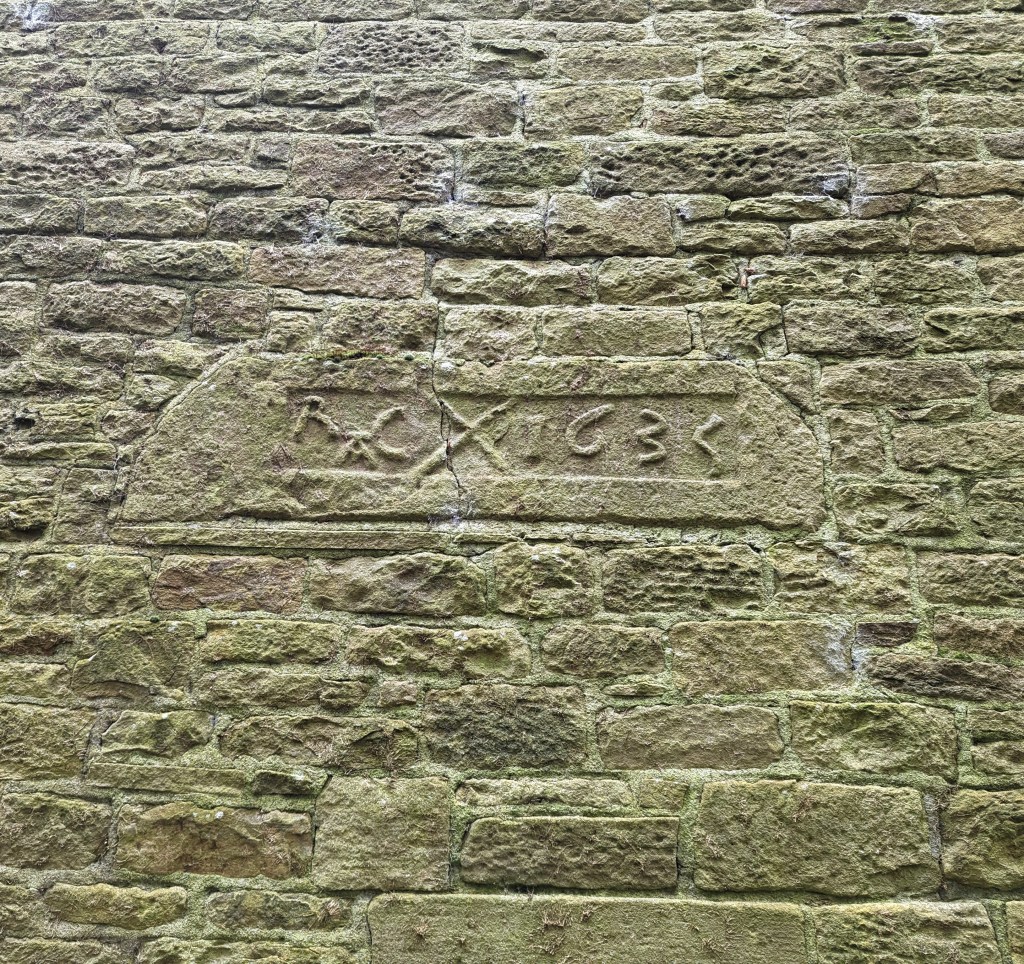
This last one, the one that started this whole merry dance, is for me the cherry on the cake, and what just about convinces me. It gets its first mention as Hargatt in 1623 in the burial record of Widow Robinson. Now, 1623 is 650 years after the time we are talking about, but placenames stick around, and rarely change; this is why we call Glossop, Glossop: some 1000+ years ago, someone described the area as “oh, you know, Glott’s Hop“… and here we all are, on this website. Perhaps more importantly, church records only go back to 1620 in Glossop – very very late, but not uncommon, so 1623 is only the first mention we have, not when the place spring into being. ‘Gate’ makes sense, but the ‘Har’ element makes little sense, until we find in 1664 it is referred to as ‘Hardgate‘, and we see that this is probably the ‘correct’ name, and that all others are variants of this – the ‘d‘ being an obvious sound to drop.

This got me thinking: Hardgate… Hard Road? And then I realised that the Roman Road from Buxton passes through the area just west of the settlement. Was Hardgate referring to the ‘Hard Road’ of the only decent road in the area, a beautifully built and ‘hard’ surfaced Roman Road, as opposed to the muddy nightmare tracks that the rest of the area was filled with, and which even in the early 1800’s were still being moaned about? I wondered about the word Hard, and on a whim I entered the English word into Google Translate. Do you know what the Norwegian word for ‘hard‘, meaning solid or inflexible is?

Hard‘.

Hargate/Hardgate simply means the ‘Hard Road’ in Norwegian. I am convinced this refers to the Roman Road in their native tongue, and that convinces me that this whole ‘Viking’ enclave in Simmondley is a real thing. At least, I’m convinced… for now; I realise I’m not a placename specialist, and that this is something of a stretch. But c’mon…

Location of the placenames

So the next time you are in the Co-Op buying beans and some bread, remember: “We Gardena in geardagum, þeodcyninga, þrym gefrunon, hu ða æþelingas ellen fremedon…” and all that!

Ok, so, I can already hear the army of linguists and placename specialists lighting torches and starting to yell. Truthfully, I’m out of my depth here, but I believe what I’ve written. If you know better, please let me know… I’m always happy to be wrong, as it’s how we learn. But more importantly, if you know of any other Norse placenames in the Simmondley area, please let me know. Part 2 of this post – coming soon – is even more contentious! And in between – probably – is another instalment of the Rough Guide to Pottery… I know you have missed it so. Although the screaming I’m hearing (and swearing… don’t think I can’t hear that too) is a little off-putting. But in l know you are only joking, so as a reward, I’ll put in extra photographs.

Until then, though, look after yourselves and each other, and until next time, I remain.

Your humble servant,

TCG

Pubs · Simmondley · Stones of Glossop

Datestones – Part 2

What ho, you wonderful and slightly strange bunch, you.

A quick one today… I have had almost no spare time to do much more. I have just finished the new edition of Where/When (No.4, The Melandra Meander) – which has taken all my time – and I’ve just started a new job! Busy busy busy! But the Cabinet of Curiosities is a priority, and you, kind and gentle readers, are very important. Plus, if I don’t publish something on the website, angry crowds start to gather outside my house, chanting and making threats – I mean to say, one has to think of the neighbours.

So here we are – a second part to the Datestone post I wrote 3 years ago (three years? Where has the time gone?). I’ll spare the introduction as the original covers that, and just dive in to say that all of the datestones are pre-Victorian (before 1837) – I’d like to do a survey of the datestones of the Victorian and later periods, but there are so many that it would be a big task. If anyone fancies giving me a hand, though, give me a shout.

So then, first up is a correction. Hurstnook Farm has a stone that I drew through a pair of binoculars, as I couldn’t get close enough to photograph it. Well, they’ve been doing some work there recently, and me being me, I wandered over and asked if I could take a snap, and Lo! The result is below.

F.S.M.W, and the date of 1772. Lovely detailing, too – this is an expensive looking stone.

And a wonderful datestone it is, too. Different from my interpretation of it, and I still have no idea of the names; W is probably the family name – possibly a Wagstaff? I’m sure looking through some deeds would produce a name, though. Any thoughts, anyone? There is another datestone on the extension next door that reads 2010, but is designed to copy the original one, to fit in with the building.

Next up is #13 Padfield Main Road, Hadfield.

J.H.A 1826. Simple and effective.

A simple datestone, but I honestly love this one. And the colouring is effective.

Next up, Hadfield Hall – a truly wonderful building. I could study this place for hours, and often find myself marvelling at the structure, and all the phases of construction. Now is not the time for a detailed look at the hall – a future post, perhaps. Still, it has a cracking datestone above the door.

I(J).H. T.A. 1646

Lovely stuff. Hadfield family? I’d love to know more – any thoughts?

Just opposite Hadfield Hall is 7 Old Hall Square:

AD 1769

A simple date, rather than a chance at immortality.

Next we have 2 from Shaw, the farmstead that is first mentioned in 1285. It forms one of a number of such places dotted around Mouselow, and is a fascinating place. I suspect there is a lot of history here, and would love to have a poke around some of the properties there. If anyone reading this in Shaw fancies letting a slightly odd bloke have a rummage, so to speak, shout out!

First is Shaw Farm Barn

G.B. (D) M.B. (B), 1694

Not a great photo, but the inscription is correct. It’s on a whacking great lintel, which is very suggestive of an earlier, perhaps Tudor, door lintel that’s been re-used. Makes you think… And then, next door, is Shaw Farm:

I (or more properly J).P. 1751, in a rather fetching shield motif.

The names here again escape me – J.P. (the ‘J’ is rendered as an ‘I’ as was the custom).

Next up, the Hare and Hounds, Simmondley.

G.B.P. 1784

I actually know the meaning of those initials – George and Peggy Booth. Also in Simmondley, we have Dingle Cottage which sits on the old trackway from the farms over Whitley Nab way.

M.L.R. 1706

A truly fascinating building, and again, one in which I wish I could have a poke around!

Next is Hall Fold Farm, Old Glossop.

J.S.J.G. 1806

The datestone was apparently found buried whilst the farmhouse was being renovated. The image is not mine, but was taken from the always interesting (and essential if you like Glossop’s history) Old Glossop History Trail website. I want to take one of my own, but oddly people view Herberts taking photographs of their houses with a bit of suspicion!

Another Old Glossop datestone is unusual – this is built into the side of Hillside Cottage, down by Laneside Farm:

R.A.C. 1635, with a decorative saltire.

A few things to say about this one. Firstly, it is the second oldest datestone in the Glossop area, pushing Hob Hill Cottage in Whitfield into third place. Secondly, the decorative saltire might also function as a protective motif, as the shape is a fairly commonly found apotropaic mark. But the important thing is that it is not in its original position, above a doorway, and in fact the house it is built into is late Georgian or early Victorian. I can only assume that it replaced an earlier building, and rather than throw the lintel away, the builders thought they might as well build it into the fabric of the house as decoration. As for the initials – I have no idea.

Next up, and finally: Flax Cottage, Wesley Street, Old Glossop.

S.W.E. 1783, and a little flower motif.

The flower motif in Flax Cottage is very similar to that at Hurstnook Farm – possibly the same stonemason carved it 11 years later?

Ok, so that’s it for datestones. There are others in the area – a few in Charlesworth, Herod Farm, Hobroyd Farm, etc. – but I don’t have photographs yet. If anyone does, or if anyone knows of any others that I don’t know about, then please give me a shout.

In other news. As I say, Where/When No.4 is about to be printed – I sent it yesterday, so it will be here next week, fingers crossed. I’m super excited about this one, and it might be the best yet. I’ll post more soon, and with other news too. But until then, look after yourselves, and each other, and I remain.

Your humble servant,

TCG

Archaeology · Medieval · Roads · Roman · Simmondley · Whitfield

Field Work

What ho, dear and lovely people, what ho! I trust you are all enjoying the weather as it bounces, somewhat insanely, from parched desert in the midst of an African heatwave to “quick Mrs C-G, gather up two of every animal you can see, whilst I look up ‘How To Build an Ark‘ on YouTube” rainstorms. I mean, it keeps you on your toes, what!

So then, I have recently become obsessed with fields and their shapes, and what they can tell us about the history of Glossop. I know, I know, I really am quite the hit at parties! Indeed, I often hear the phrase “oh great, TCG has arrived!”… it’s nice to be appreciated. As an aside, 7-year-old Master C-G has recently taken to mocking me by asking a question about, for example, pottery, and then interrupting the answer with “wow dad, that’s soooo interesting…” and walking off, before falling down in fits of laughter. I mean to say, that’s a tad off, what? Where’s the blighter’s respect for dearest pater?

Anyway, where was I? Oh yes, field shapes and history. So, if you look at any OS map, you’ll see that it is criss-crossed with lines which mark out the boundaries of fields. On the ground and in real life these boundaries are made up of fences, hedges, or, in this part of the world, with drystone walling. It takes time and effort to build these walls, and more time and effort to take them down, which means it doesn’t happen very often. And unless the area has been significantly changed or has been built over completely, the field boundaries you see on the map and on the ground have been there since they were laid out. And here it gets interesting: the way fields were laid out changed over time – their shapes reflecting contemporary farming techniques – and it this which allows us to date them and their associated settlements.

Looking at local examples chronologically then, we start at the beginning. Quite literally. The first farmers – those neolithic & bronze age types who initially took the huge risk to cease the hunter-gatherer nomadic lifestyle, and instead adopt a sedentary one based around agriculture – created the first fields. Evidence from elsewhere suggests that these were not fields as such, more areas of land cleared of trees – a formidable task using only stone or at best bronze tools – and the area cleared of stones to enable to plough to pass. The larger stones are normally found rolled to the edges of the cleared areas, and there are often clearance cairns associated with them – piles of rocks, essentially. There are suggestions of bronze age systems in the area, but nothing even close to definite, and certainly nothing worth describing.

There is a similar situation with the Romano-British field systems, of which there is one possible example, in Whitfield, to the north and south of Kidd Road. These seem to comprise a series of lumps and bumps in the ground that might be the remains of field boundaries, or of terracing on which agriculture took place.

The potential field system is in yellow, the Roman road from Navio is in red. Image stolen and altered from the Derbyshire HER website.

As the Roman road from the fort at Brough (Navio) runs just by there, it would be a good place for a farmstead, and I’m sure more existed nearer Melandra. It’s not terribly inspiring, if I’m honest, but it is interesting, and if it is Romano-British in date (43AD – 410AD, perhaps a little later, too… or possibly a little earlier), then it is proof that people have lived and farmed in Whitfield for over 2000 years. You can read a bit more about it on the Derbyshire Historic Environment Record here, or, the Glossop & Longdendale Archaeological Society website, here.

However, our first definite and recognisable field systems occur in the medieval period.

By 1086, Longdendale and Glossop had been designated Royal Forest, a situation which brought with it all sorts of restrictions for the residents of the seven villages that made up the area at the time of the Domesday Survey: Chunal, Whitfield, Charlesworth, Hadfield, Padfield, Dinting, and Glossop (I’m convinced there was something at Simmondley and Gamesley at the time, but were overlooked or ignored as too small to tax). It was particularly particularly restrictive around land use; the existing villages were allowed to continue, but were not allowed to expand their size in anyway, as this would affect the king’s land, and take food from his deer. That didn’t stop them, though. What few records we have of medieval Glossop make mention of the crime of assarting, that is to cut down trees to enable the land to be used for growing crops or grazing – essentially increasing your land, illegally. For example, in 1285 we find the following:

“The wood of Shelf has been damaged in its underwood to a value of 15 shillings by the villagers of Gloshop, fined 4 shillings, they must answer for 60 oaks”.

The process would have been gradual, and probably done sneakily, perhaps by bribing the forester to look the other way. Or equally, it may have been worth the fine if you can increase your farming lands significantly – an investment of sorts. Given the nature of assarting – essentially picking away a few trees at a time – it often leaves a distinctive field shape: rounded, rather than straight or uneven lines. There is a perfect example of this at Ogden, above Tintwistle:

The two farmsteads of Ogden, both now in ruins. I need to explore up there sometime.

And if we look over at Hargate Hill, between Charlesworth and Simmondley, I think we can see a similar process happening here:

Rounded edges, rather than the more usual straight.

The circular, almost organic growth of the fields can be seen, and it may be this that is referred to in 1285: “The wood of Coumbes (Coombs) has been damaged by the people of Chasseworth (Charlesworth), fined 2 shillings, they must respond for 18 oaks.” This whole area is full of interesting detail. The first mention of Hargate Hill I’m aware of is 1623 (the record of the burial of ‘Widow Robinson’ of Hargate on 10th July, to be precise), but there must have been something there before this date. There is a suspicion that stone from the quarry here was used to build Melandra Roman fort, although how true this is, is not clear, but the settlement is just off the main road between Glossop (via Simmondley) and Charlesworth, which is significant. Importantly, between the road and settlement, there is evidence for Ridge and Furrow ploughing, which is normally medieval in date. You can see it in this LIDAR image:

The ridge & furrow is running roughly north-south from High Lane.

Ridge and furrow is created by ploughing up and down a strip of land using a team of 8 oxen. Now, as you can imagine, 8 oxen are a nightmare to turn, and their size alone means that you have to start the turn very early on in your plough furrow in order to maximize the land use. This creates a distinctive reverse ‘S’ shape to the thin fields – or ‘selions’ – that make up the medieval farm landscape – the result of only being able to turn the oxen to the left (as the medieval farmer used a fixed blade plough share that was positioned on the right). These selions are side by side, with a dip in between (you can just about make out the dips in the above LIDAR image), and made up of rows and rows of ridge and furrow running the length of the selion. A selion normally measured a furlong in length (a ‘furrow long’: some 220 yards) and between 5 and 22 yards wide.

In Whitfield there are many great examples of this classic, and instantly recognisable, early medieval field shape.

Clearly visible, running NW-SE, and on either side of Cliffe Road. There are dozens more in dotted about the area, too.

Hiding in plain sight, the medieval field systems of the 12th & 13th centuries. The fact that they run either side of Cliffe Road is significant: they ‘respect’ the road, which means that the road was there before the selions, as it is highly unlikely a road would be put through arable land. We know this anyway – it was the main road from Glossop to Chapel en le Frith – but it is good to have it confirmed.

What I find amazing me is the sense of continuity of use; the field marked with a red ring in the above map is exactly the field boundary of the Whitfield Allotments, and I wonder how many allotment holders realise their plot of land has been continuously farmed for nearly a millennium. It’s also fascinating to think that although the area has been largely built over, the boundaries of individual modern house plots have used these field boundaries as references, and so the field laid out by a medieval peasant farmer 800 or more years ago has a direct influence on life today. Looking at a tangible history in that way leaves one feeling quite dizzy.

Chunal, first mentioned in the Domesday Book, was an important medieval farmestead.

Chunal is even clearer in its agricultural history, and has evidence of both assarting and the use of Ridge and Furrow on both sides of the road, especially what is hidden beneath the surface now – compare the above map with the LIDAR survey of the same area… huge numbers of selions, all in the classic reverse ‘S’ shape.

The same area scanned with LIDAR. The selions not shown in the above map are very clear.

The quantity of field strips is testament to the relatively large-scale agriculture occurring in this area in the earlier medieval period. Simmondley, too, has a large number to the north and south of Old Lane, which was the original medieval track from Charlesworth via Simmondley to Glossop:

Notice the selions ‘respect’ the original track – Old Lane – they stop at the road, and don’t line up symmetrically on the other side. They are, however, overlain by the New Road which was built, I believe, in the 1860’s. Just as in Cliffe Road in Whitfield, Old Lane must have been there when the selions were laid out, or at the same time, giving us a date for the track.

During the 14th century, however, we see a shift in farming practice, and land use moves away from the ‘open field’ system of strips, and starts to become enclosed by walls. This is probably a result of two critical events. Firstly, the climate starts to get colder, which has a negative impact on the ability to grow crops, and which lead to a series of famines. The second was the emergence of the Black Death which killed off 1/3 of the population during 1348-49. And whilst the Peak District emerged seemingly relatively unscathed, no doubt there was a movement of the population to better arable land that had been abandoned, leading to a population decline. It had also become apparent by the mid century that sheep/wool farming was a lucrative market, and thus increasing amounts of land was blocked off to allow sheep to graze safely. These early enclosures are normally recognisable as non-symmetrical enclosures that have largely straight-ish lines, but aren’t a specific shape. We can see some probable examples to the north of Simmondley New Road, now covered by housing but preserved in the 1892 1:25 inch map:

Simmondley New Road running west-east(ish) replaced Old Lane… the clue is in the names!

If we look closely we can see these early enclosures are made by consolidating and expanding existing selions, as farming practice shifted from arable to livestock. The more you look, the more the medieval and early modern landscape comes to life.

We also encounter them at Gamesley, now also covered by housing, but perhaps originally associated with Lower Gamesley Farm which may have an early foundation date, even if the present building there dates from only the 17th century (only…!). The settlement is first mentioned in 1285, but actually Gamesley is a Saxon name meaning the ‘clearing (or assart) belonging to Gamall’.

Gamesley, to the south of Melandra.

Of course, people needed agricultural produce, and many strips continued to be farmed well into the post-medieval period. Indeed new fields were laid out, although later ridge and furrow is normally straight as, over time, smaller teams of larger oxen were used, and these were eventually replaced altogether by heavy horses.

Our final field type comes at the end of the 18th and early 19th centuries with the parliamentary enclosures. Briefly, open ‘common’ land – poor rough land, owned by the Lord of the Manor, but used by everyone to graze animals or to gather fuel – was parcelled off and sold in lots. On paper, this freed up lots of land and was a boon for farmers who could, with a little improvement, massively increase their lands. But it also meant that the common man lost access to land that his ancestors had legal rights to. Arguably, by the early 19th century there were very few people who would have used the land anyway; not many people had animals to graze, nor did many burn peat as a fuel. The rural way of life, especially in Glossop, was well and truly over and most people lived in stone terraces and worked in mills. But that really isn’t the point! The parcelling up of the land into lots was done drawing lines over maps using rulers… and it shows.

Moorfield is surrounded by fields that are the result of the 1813 Whitfield Enclosure Act.

And elsewhere:

The area to the north of Glossop

Around Lanehead farm, toward Padfield there are clear examples of 19th century enclosure… in fact they are all over Glossopdale – have a look at any map. They often mask earlier field systems and tracks which can be on a different alignment, and a quick scan of the Lidar for the same area reveals all sorts of lumps and bumps:

Lanehead Farm is shown by the orange arrow.

The grey arrows above show older field systems not shown on the map. In the middle of the arrows there is what might be ridge and furrow. A detailed study of the fields on the maps and on the ground, as well as a comparative reading of the lidar could give us huge amounts of information about the past use of the landscape, beyond the obvious parliamentary enclosures.

The lines of these fields are all very straight, and all the walls are of a standard form, and the whole parliamentary enclosure process was completed with characteristic Georgian and Victorian efficiency. But a part of me feels that it is almost an industrialisation of the landscape, a triumph of efficiency over nature. Prior to this, it was a difficult process to carve out a little patch of land to support your family, and it required blood, sweat, and tears. This human, organic, side is etched onto the land – assarting, the reverse ‘S’ shape, even the enclosures for sheep, they all have an element that is dictated to by the land, and all came with effort. To stand over a map with a pen and ruler dividing up the landscape is to have a complete disconnect from it, and is human imposing on it, rather than working within it, and that feels wrong somehow. Anyway, enough of the hippy!

It genuinely is amazing what you can see when you start to study maps, the unexpected can leap out at you. Keep looking, wonderful people, and please mail me with anything you find – I could even make you famous* by publishing it on the website.

*famous to all 11 people who read the website, that is.

Anyway, I hope you have enjoyed todays romp around the countryside. I’m planning a few more official Cabinet of Curiosities wanders over the summer, one of which is a jaunt down the medieval and early modern trackways of Whitfield and Glossop via 2 pubs and a pile of history and archaeology… what’s not to love? And all at a bargain price… a man has to eat, after all. Watch this space. Or Twitter. Or Instagram, if I can figure how to use it properly.

Until next time, keep looking down, but also look after yourselves and each other.

I remain, your humble servant,

TCG

History · Placenames · Simmondley

The One Glossop… and the Many Glossops

What ho, wonderful folk! Summer is almost upon us, and we enter the finest time of year. Now don’t get me wrong, I’m fond of spring, and autumn is good. Even winter with it’s cold and dark can be lightened and warmed with a good fire and a glass of the stuff that cheers (if taken in the right dosage, as I am often reminded by the good Mrs C-G). But no, ask old TC-G which season he likes most, and the answer will always be… summer. This time of year fills me with a particular joy; it puts a spring in my step, a smile on the old fizzog, and a stirring in the loins (although that’s possibly the onion soup I had for lunch). Summer is indeed ‘icumen in’.

And indeed, it’s the stuff that cheers that leads us to today’s blog post – something a bit different, but fret not dear and gentle readers, for when have I ever steered you wrong?

I wonder then have you ever found yourself, glass in hand and perhaps swaying slightly, in a place to which you never set out to journey? I certainly have (and no, not that Turkish bordello… for the last time, I was only in there to ask for directions to the post office). No, a chance encounter with a place, perhaps exotic, otherworldy, strange and alien, like no other place on earth, and yet familiar? A few months ago I found myself, quite by accident, in The Globe pub quiz (and good evening JS!). It was a difficult quiz, and involved much mashing of the old B, and a distinct straining of the dashed M… if you catch one’s meaning.

But one question in particular flummoxed me: “How many Glossops are there?”.

I mean, there’s an existential crisis… what? Why surely there is only one? The singular, unique, one-of-a-kind place that we call home. This royal throne of kings, this scepter’d isle. This earth of majesty, this seat of Mars, this other Eden, demi-paradise. This fortress built by Nature for herself against infection and the hand of war. This blessed plot, this earth, this realm. This Glossop. (ok, I might have had a bit of help with the words there… my thanks to William what’s-his-face).

But no… apparently there are three. Who knew? Well, the quizmaster did. And several of the other teams did, apparently. But I bloody well didn’t. Not that I’m bitter or anything. And besides, none of the other teams could answer any of the questions in the ‘Pottery Identification’ round (alas, if only such a wondrous beast existed… one can but dream). 

So then, two other Glossops… blimey, there’s a thought. What wonders could these places offer us, what unearthly delights akin to the Globe quiz? Well, dear and gentle reader, let’s find out.

Introducing Glossop Number 2

Where the red pin is, lies another Glossop, on the other side of the world.

Glossop, South Australia. A town roughly 250 miles north east of Adelaide (and just a mile or so north of the splendidly named township of ‘Winkie’). It’s a small place, with a population in 2016 of just 984 (compared with our Glossop’s 33,340 in 2021), mainly rural, and surrounded on all sides by vineyards – it’s right in the wine growing region, lucky people! (and presumably then the weather would be a tad warmer than that found in our corner of North Derbyshire!).

I am in awe of its triangular shape!

It was founded in 1921 as a settlement for returning soldiers, and is named after the equally splendidly named Vice Admiral John Collings Taswell Glossop (if anyone knows their Jeeves and Wooster, this could be Tuppy Glossop’s uncle). Vice Admiral Glossop was in command of HMAS Australia during the First World War, and was very active in the Royal Navy’s Australian wing.  

A little different from High Street West, this is Campbell Street, Glossop.

There looks to be some great camping and hiking to be done in the area, and there are several national parks based around the Murray River there. That stated, there’s not a lot more to say about the place, to be honest, but do feel free to have an explore on the internet, or in real life (oooooh, a tour of the wine country could be fun!). If you live in Glossop, Australia, and have stumbled upon this site, then please let yourself be known – we’d love to hear from you. 

But wait, there’s more!

In New South Wales, Australia, there is a Glossop Reservoir. Situated near to the village of Linden, 40 miles NW of Sydney, it’s located at the end of Glossop Road, and absolutely smack dab in the middle of nowhere.

Glossop reservoir is the round thing at the end of Glossop Road.

I wonder why they have the name Glossop? Perhaps also connected to our man Vice Admiral Glossop? There is no more information I can find out about this place at all, so any information you have would be gratefully received.

And now for Glossop Number 3.

Will this Glossop be a throbbing metropolis? A mecca of marvelousness? A seething mass of humanity? A place of culture and wonder, or a modern-day Sodom and Gomorrah? Well, not exactly…

Ladies and gentlemen, welcome to Glossop, Manitoba, Canada.

What wonders await under that red pin?

Well, what can we say about Glossop, Manitoba.

Well, no matter how you feel about Glossop, Derbyshire, it has something going for it. And as small as Glossop, South Australia, is, it has life… in that people actually live there. Glossop, Manitoba is… well… a road, next to a rail track. With some grain elevators on it.

Glossop, Manitoba… what can I say?

There must be something nearby… surely. Let’s look down the road:

Nope, nothing this way, let’s look behind us…
Nope, nothing.

What we can say is that it is situated 604m (1982ft) above sea level, is on the trans-Canadian Yellowhead highway, and is broadly equidistant between the settlements of Newdale and Strathclair… both of which seem to be quite nice, if on the small size (population “perhaps 200” and 709 respectively). What we can’t say, however, is why this place has the name Glossop, although presumably it’s named after someone with that surname.

However, a little more digging and… it turns out the grain silos are interesting.

Copyright Steve Boyko, and borrowed from this website.

Well… ok, let’s be honest for a moment, anyone who has ever read anything on this website knows that the word ‘interesting’ is very flexible (and honestly, we have stretched that word to the limit on this site), and I’m painfully aware that my particular niche interest doesn’t ring everyone’s bell. But even by our own relaxed standards, these grain elevators aren’t exactly riveting. However, this is exactly the sort of thing the internet was invented for – people with niche and minority interests meeting each other and sharing information – after all I’m here writing this, and all six of you (including Pablo in Puerto Rico… hola Pablo!) are out there reading it. The website ‘Grain Elevators of Canada’ has a whole page dedicated to those at Glossop, Manitoba, but I’m not going to steal their thunder, instead please do go and have a look at it.

But wait, there’s more…

Some 350 miles north east of Glossop, Manitoba, is Glossop Lake.

Even by Canadian standards, this place is in the middle of nowhere: 40 miles NE of the nearest settlement (Pikwitonei, population 55), and 150 miles east of Thompson, the ‘capital’ of northern Manitoba (population “fewer than 15,000”). You could only get to this place by hiking for several days, or possibly by boat. It is truly remote.

Which makes it particularly baffling that the only information about Glossop Lake available on the internet are from a Wikipedia page written in Cebuano, a language spoken almost exclusively in the Southern Phillipines… and with no obvious connection with an obscure lake in the frozen north of the Canadian wilds! Bizarre!

So what can we say about Lake Glossop. Well, it’s a shallow lake, situated 200m above sea level, and covers an area of 1.35km2. It is mostly pine covered, and the average temperature for the area is -5… so you’ll probably not want to go skinny dipping any time soon. There is neither a photograph, nor an explanation as to why it is called Glossop Lake, though presumably again named after a person.

So there we have it – the many Glossops of the world. I’d like to do a roadtrip to find these places, but honestly… that seems like a lot of hard work for very little reward! However, if anyone is going to any of the places mentioned, please let me know.

And whilst this post is not overtly archaeological, it does have some relevance. Gamesley, Simmondley, and even Glossop itself are all named after people, and all were imposed on the landscape by Anglo-Saxon settlers. What the native British (the ‘Celtic’ Romano British) called the area, if it had one, is lost to us (Dinting being the exception). This habit of naming after people or features in your own language can also be very helpful in identifying settlement patterns, ages, and the origins of the people doing the naming. And here it does get interesting. Simmondley means “the clearing” (or ley) belonging to someone called either Sigemund or Sigmundr. The former is a Saxon name, but the latter, however, is a Norse (Viking) name, and that might be important. I have a pet theory… we know that a small group of Scandinavians were allowed to settle in the hills to the east of Manchester, and there are a cluster of possible/probable Scandinavian names in the Simmondly area: sitch, storth, gate, nab, and possibly others. It makes me wonder if Simmondley’s origins are more Viking than Saxon. Just a thought, but it does illustrate the importance of names in a landscape. I’ll expand on this another time.

But for now, take care of yourselves and each other.

And I remain, your humble servant

TCG

Placenames · Simmondley · Waterways of Glossop

Bridgefield

Good evening.

(well, it is here and now, but I suppose it depends on when you are reading this… in which case, feel free to substitute “evening” for whatever part of the day you happen to be reading this.)

Perhaps I should start again.

What ho!

A short one today – I realise that I haven’t been as active as I’d like, so rather than labour over a larger post, and as a sort of proof that I’m still alive, I present today’s smaller offering – the area of Glossop known as Bridgefield. This is a place you drive through without ever noticing it is there – blink and you miss it as you go from Charlestown to Dinting along Primrose Lane. It is also a great example of why maps are so useful as a record of places – without it being drawn on the map, it is likely that Bridgefield would have ceased to be remembered as a place at all.

I have commented elsewhere that older names for places are usually based on reality, and reflect a different set of priorities – largely truthfulness in description: Gnat Hole was not named ironically, and so it is with Bridgefield, it was – and is – the field with the bridge. Well, actually bridges, plural – there are two. The first is where Primrose Lane crosses Long Clough Brook, circled in blue on the map below. But it is the second one – a small footbridge over the Long Clough Brook – that I think is the more interesting of the pair, and is indeed the older. Moreover, it actually is in the ‘Bridge Field’, rather than two fields over. And so, this humble little bridge is the target of today’s fevered ramblings. The bridge, or to be precise an earlier incarnation, is circled in green in the map below.

A rather colourful rendering. The bridge of Bridgefield is marked in green.

It crosses Long Clough Brook at the bottom of Slatelands Road, and now forms the bottom end of a footpath from Pikes Lane, emerging into Primrose Lane. This track – marked in red in the map above – wends its way between houses and land, and is known locally as the Chicken Run; indeed it still has chickens at the bottom. It was also known as the ‘Giggle Gaggle’, apparently, which recalls strongly the ‘Gibble Gabble’ in Broadbottom – another track that wends its way between houses and land. Indeed, it is suggested that Gibble Gabble (and thus Giggle Gaggle) is a localised (Mottram, Broadbottom, Glossop) dialect name for what is known elsewhere as a ‘ginnel’ (a track that wends its way between houses and land), which makes sense (here is a little more on the subject). According to A Journey Through Glossop by Kate Best and Owen Russell this same trackway was also known as Burneen by the nuns of the convent on Shaw Street, who used it to get to Hobroyd. Burneen is a version of the Irish term, Boreen, which means… anyone? Anyone? That’s right – a track, usually one that wends its way between houses, etc. There is a theme here… if only I could spot it. David Frith in his Pathwise in Glossop and Longdendale (p.60, Path 40) notes that this path went through allotments, and was known as the ‘Flagged Fields’, again strongly suggestive of a maintained trackway or road.

Joking aside this track is very important; I am convinced it forms part of the medieval road (such as it was) between Charlesworth, via Simmondley, to (Old) Glossop. The track goes along Old Lane in Simmondley (the name is a clue), down a sunken trackway that might indicate both age and heavy use, and emerges along another ‘fossilised’ footpath, preserving the original trackway ‘in stone’ – here, at the bottom of Simmondley New Road and Moorside Close:

The tail end of the track that comes from Charlesworth via Simmondley (Old Lane).

It continues along the footpath until it meets Pike’s Lane. This track will be the subject of a future blog post as it is a vital part of the history of the area, and well worth an explore, but for now let’s return to the bridge. Here it is, then, the current bridge of Bridgefield.

The bridge over the brook.

This bridge is quite modern, being made from rolled steel ‘I Beams‘, and it is clearly the latest in a long line of bridges of various sorts.

It works as a bridge, but it’s certainly not romantic.

We may assume that the earlier bridges were made from stone in one form or another, but looking into the brook, I noticed some large flat stones – much bigger and more substantial than paving slabs – that look out of place.

They’re not easy to make out, but the slabs are dotted along this stretch of Long Clough Brook, directly below the bridge. Incidentally, the Brook marks the border between Whitfield and Simmondley – as we look at the photo above, Simmmondley is on the right, Whitfield left.

Am I wrong to imagine that these once might have made up the medieval and early modern bridge in the form of a Clapper Bridge? The stones having fallen, but not moved very far by man or water.

A Clapper Bridge. This example is at Postbridge in Dartmoor, but they are a common way of forming a river crossing, especially where the banks are high – as they are at Bridgefield.

If I’m honest, I probably am wrong; the whole area has been extensively messed around with by the building of mills and mill ponds, as well as work on the brook itself with the building of weirs and shaping the banks. It’s difficult to get an idea what the area would have looked like, and it’s unlikely that any vestiges of the original bridge remain. But still, let’s imagine.

EDIT

Actually, further evidence to support the Clapper Bridge idea might be suggested by the fact that Slatelands Road, which runs down to the bridge, was once known as ‘Stoney Causey‘, the Stoney Causeway. The word ’causeway’ normally indicates a raised roadway across wet ground, as opposed to a bridge per se. which would fit quite nicely.

However, the importance that was once given to Bridgefield is underlined by the fact that the Reverend John Wesley, the founder of Methodism, preached here. Now, that Wesley preached in Glossop is not in itself big news – he preached all over, favouring the open air, and had a fondness for this part of England, returning time and again to spread the word of his particular brand of Christianity. But the fact that he chose Bridgefield as the location for the crowds of people that would have gathered – some jeering and making mock, others listening intently and converting – is significant. It indicates that this was an important place, and vital in communicating between towns – Glossop and Charlesworth/Simmondley, but also one that was well known enough that people all over Glossop would come and hear him. In his diary, Wesley records the following entry:

Friday, 27th March 1761
“I rode to Bridgefield, in the midst of the Derbyshire mountains, and cried to a large congregation, “If any man thirst, let him come unto me and drink.” And they did indeed drink in the word, as the thirsty earth the showers.”

Well there you go. Who knew that this often overlooked corner of Glossop had an interesting history. As I say, I’m going to blog about the Charlesworth to Glossop track in a future post as it’s a hugely important thing, and part of a larger project that is trying to identify all such trackways in the immediate area. I also recently did some mudlarking in Long Clough Brook, so should probably post the results.

Right, until next time, please take care of yourselves and each other.

I remain, your humble servant.

RH.