What ho, delightful historical types (hysterical types?)! Welcome to a new article… don’t worry too much, it’s not pottery (I’m saving that for next time). Nope. This one looks at an interesting feature of Glossop’s personality. Buckle up!
So, some posts I can polish off in an evening (glass of stuff that cheers in hand, obviously). Others takes weeks to brew, and the process can be painfully slow. This one, though, is very different. I started writing it in August 2017… and it’s taken just under 8 years to publish it! No reason as such, it’s just I paused writing it, and moved onto something else, then I went back to it, and then did the same, and so on, and never quite finishing it. In fact, it’s so old, that it was written using an older version of WordPress (the platform I use for my website) which wasn’t really useable any more, and I had to paste the entire thing onto the newer version. Well, here we go.
It’s often said that Glossop is a town of different areas, and with different character. When I first moved here, I realised that a lot of these areas were named ‘town’ – Howard Town, for example. On a simple level, ‘town‘ here refers to a collection of houses in an area rather than the traditional meaning of a large urban conurbation. I wonder of this is a local dialect, or perhaps more likely, Howard Town was named as such, and then the others followed suit, possibly ironically (Roughtown), or perhaps as a way of keeping in fashion (Milltown? Anway, this and is a which got me thinking… how many of these towns are there? And where are they all?
Well, in answer to these questions, may I present…
MILLTOWN
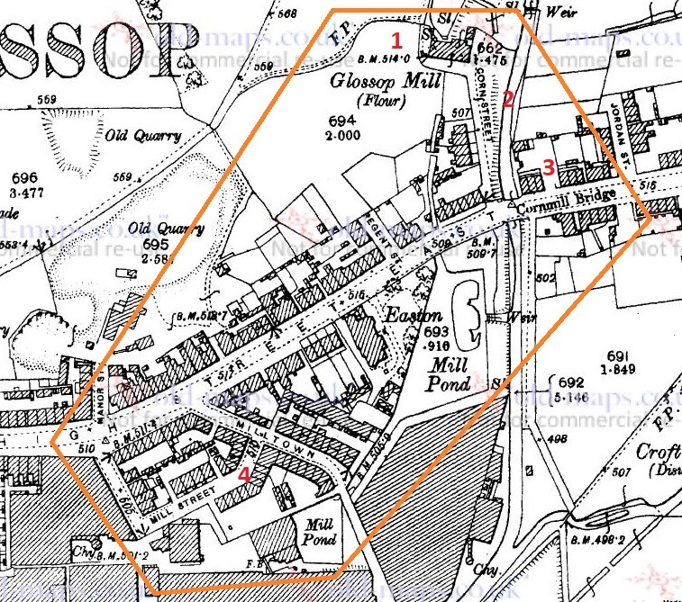
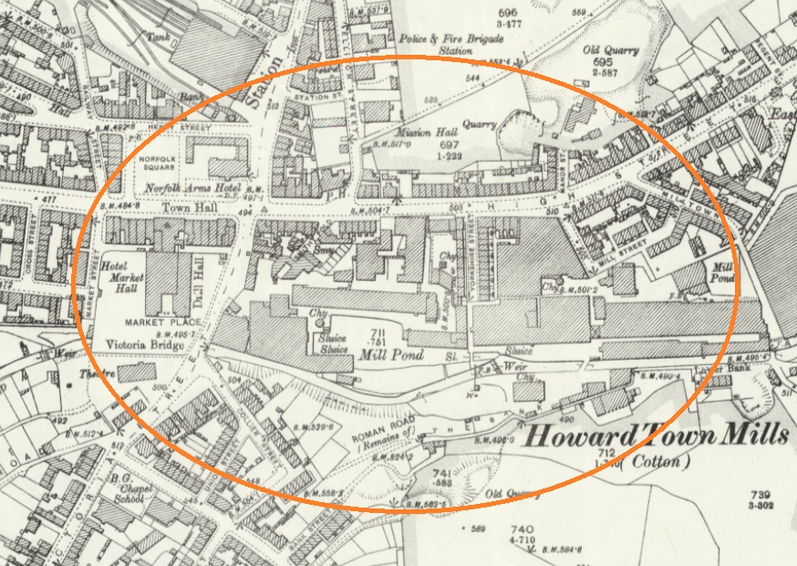
Despite its location, and seemingly obvious derivation, Milltown as an area has nothing to do with the Victorian mills, but instead it is so named because of its proximity to the medieval corn mill. Situated on what is now Corn Street, the mill was owned by the Lord of the Manor, and the people of the area paid to have their corn ground there – and nowhere else. It was, to all intents and purposes, a bit of a racket, but one that was universal throughout the land at the time. As you can see from the map below (and from photographs), there was a flour mill here in 1898, an 18th century building replacing an earlier one. It was demolished in the 1920’s, but you can still see the mill leat running alongside Corn Street. Also, the bridge over Shelf Brook as called Cornmill Bridge, which I did not know until just before I wrote these words… I love that!
Milltown marked in orange, to include the Corn Mill. In reality, Milltown is now just the area to the south of High Street East. On the map above, you can see the Corn Mill (1), Corn Street (2), and Cornmill Bridge (3). Milltown as a present day place is that to the south of High Street East, and comprising Milltown (the street) and Mill Street (4). The area has changed massively, but one constant is the Prince of Wales pub on the corner of those streets (I blogged about it here); pubs are often the only thing left after whole streets are demolished, as indeed is the case here.
LEAN TOWN
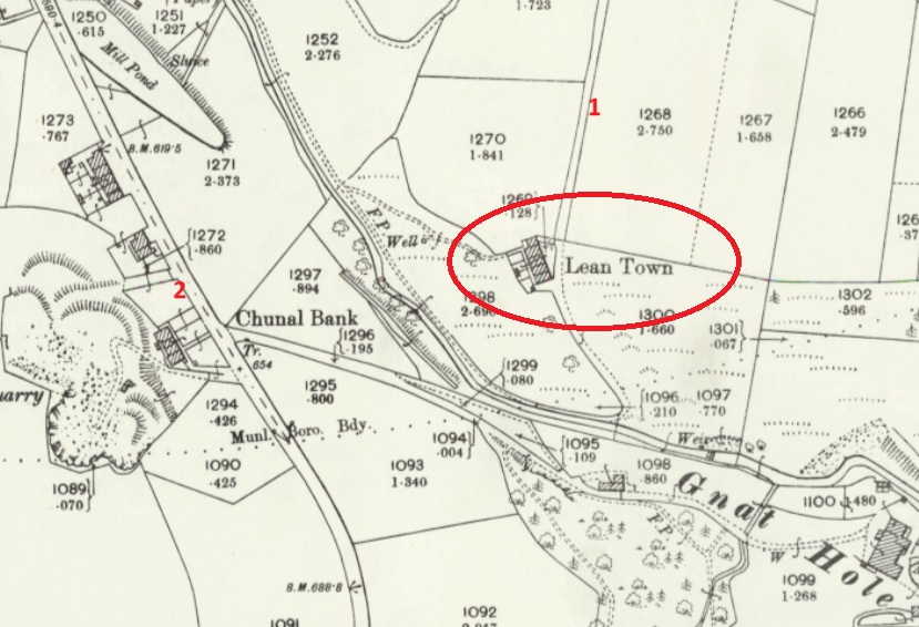
Lean Town is the name given to a group of four houses at the bottom of an apparently unnamed lane that runs from Hague Road to Gnat Hole. I can’t believe it is unnamed, but there you go… no map or document has so far given me a name! As you come from The Beehive toward Derbyshire Level, you pass a right hand downward track – follow this and eventually you hit Lean town. I wrote about Lean Town, here.
Lean Town. 1 is the track down from Derbyshire Level, 2 is Chunal.
The origin of the name ‘Lean Town’ is unclear; it might mean lean, as in not very rich, or poor for growing crops, or might be derived from ‘ling’, meaning the plant ‘heather‘ that grows around here.
CHARLESTOWN
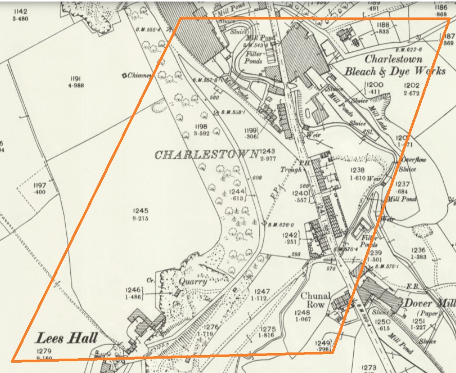
Once an area in its own right, it is now largely remembered in the name of Charlestown Road (and Charlestown Motors who I can heartily recommend, as it happens). It was named after Charles Hadfield who lived in Lees Hall in the late 18th century, and built the mill in Charlestown (now flats and houses).
Sort of this area, give or take. Charlestown Road runs from top down, and the PH (Public House) marked on the map is now Steak Land (replacing a firm favourite of mine, Casa d’Italia, although the word on the street is the Steak Land is amazing, so there’s that!)
ROUGHTOWN
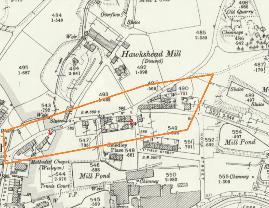
Hope Street in Old Glossop was known as Roughtown, seemingly referring to the uncouth behaviour of its inhabitants, largely quarrymen from the nearby Glossop Low Quarries just up the road.
1 – Hope Street, 2 – The Greyhound pub, a factor in Roughtown’s reputation.
Apparently Roughtown was used as a semi-official name, with it appearing on census returns and trade directories of the time. Sticking with Old Glossop, we have…
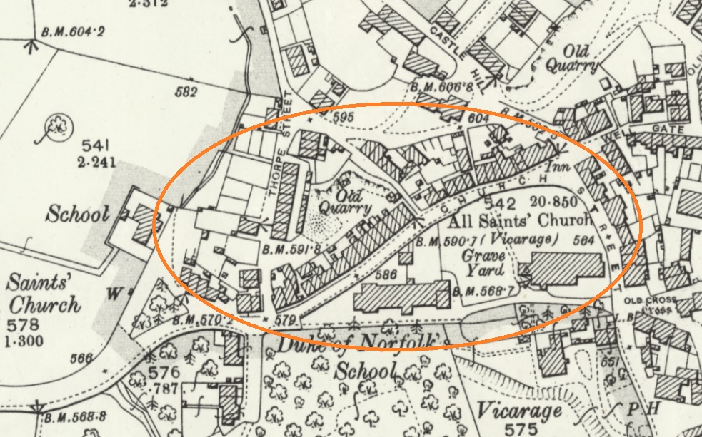
TOP O’ TH’ TOWN
The area between Thorp Street and Church Street in Old Glossop. It is, I suppose, quite literally the top of the town.
And the area at the end of Top o’ th’ Town is known as ‘Town End‘, which make sense. Over in Whitfield, however, we have…
FREETOWN
Stretches from the bottom of Whitfield Cross to the junction with Charlestown Road.
This sort of area, here. and particularly the road called Freetown.
Technically, and originally, Freetown was the name given to this area of Whitfield, with the name being derived from the fact that the land in this area, and subsequent houses built here, were freehold, as indeed it is still the case (my own house here included).
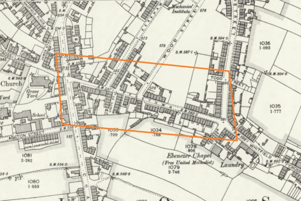
HOWARD TOWN
Essentially, what we understand as Glossop – the railway, Norfolk Square, the crossroads, and the whole area around the market and Wetherspoons.
Named after Bernard Edward Howard, 12th Duke of Norfolk (1765-1842) who invested heavily in Glossop – money and time. He built roads, the town hall, remodelled the whole area, and changed the focus of Glossop from what we now know as Old Glossop to what we now know as Glossop, but was originally Howard Town. This may have been the start of the ‘town’ naming process, as others followed suit, whether by flattery or through satire.
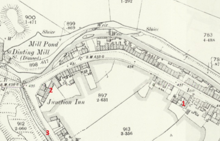
JERRYTOWN
A bit of an obscure one this – it’s mentioned by Hamnett as stretching along High Street West, from roughly The Grapes inn to the former Junction Inn and around.
1 – The Grapes, 2 – The former Junction Inn (now Simple Lettings), 3 – Primrose Lane.
Apparently named after a Jerry Sykes (1779 – 1856) who built a number of houses in this area in the 1820’s.
And there we have it! The many towns of Glossop town. I can already feel several of you desperate to tell me that I’ve got something wrong, or that I’ve missed a ‘town’ out. Please feel free to do so. Honestly, please let me know if I’ve messed up – I’d rather the information was correct.
I do have pottery for next time, and I owe you a new Rough Guide To Pottery – Part 11 unless I’m mistaken, you lucky people, you.
In other news, I’m doing a guided walk at the end of the month… which should be amazing.
Now that spring is coming I’m going to be walking the route of the Where/Whens so far published, and trying out some other new routes. Tickets for these will be available after the above walk has been done, and will be at the weekend, so everyone can take part – come and join us! Watch this space.
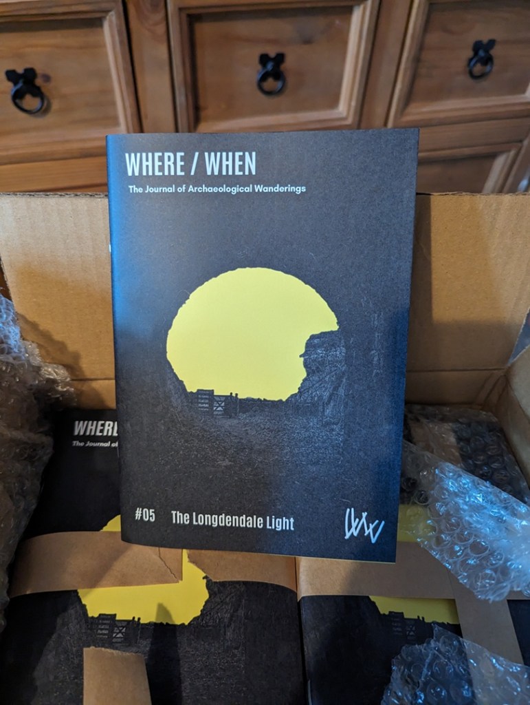
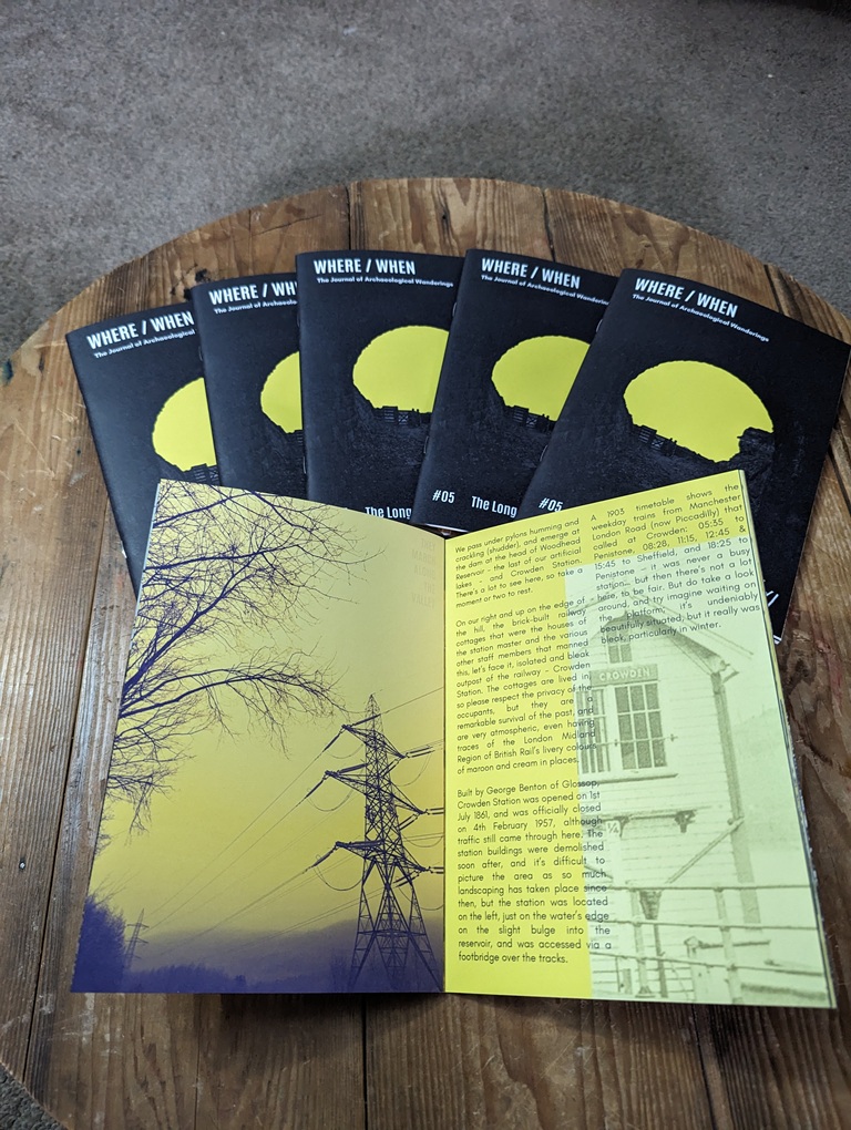
Talking of Where/When, No.5 has just been released.
An exploration of the history and archaeology of the Longdendale Trail, from the start at Hadfield to the tunnel entrances. Honestly, there is so much to see.
It’s available to buy from the usual places – Dark Peak Books, 96 High Street West, Glossop; the website’s store; or you can track me down and buy one.
I’m busy! Too busy, but it’s happening! I’ll post again soon, but until then, please look after yourselves, and each other, and I remain.
What ho, people, what ho! I hope you are all well and are suitably recovered after the Christmas season?
A word heavy – and pottery light – blog post today (those of you cheering at the back… don’t think I can’t hear you). It’s also a little speculative, too. Archaeology, and indeed history, rely on interpretation, and how we understand and use the evidence presented to us affects the story we tell. We don’t always have all the answers, and we do make mistakes, but speculation is essential, so let’s imagine… today’s story is of Anglo-Saxon Glossop, so buckle up!
Now, I love a good placename or two. Ask anyone who knows me and they’ll say “Oh yes, old TCG loves a good placename or two. He really loves them”. And then they’ll give a look. That look. I’ve never worked out what it means, that look, but shortly after the person who asked will give a nod of recognition, and say something along the lines of “… oh! I see!” And then both will turn to me, cock their heads and smile kindly, and give me an entirely different look, one of benevolence and calmness, that seems to say “awww, bless you“. Worryingly, I often get the same look from Mrs CG and Master CG. Anyway, moving swiftly on.
So then, Glossop in the Anglo-Saxon period; the Dark Ages, so-called due to the lack of historical knowledge. This is, truthfully, something of a misnomer, and our understanding of the turbulent period of 600 years between the Romans ‘leaving’ (410AD) and the Norman Invasion (1066) is becoming clearer all the time… mostly. For our own area, though, it is still by and large a black hole of historical detail. We know something was here during this time – we have Roman (certainly early Roman), and it’s highly unlikely that the military abandonment of Melandra (probably later 2nd century AD) meant that everyone left the area, especially given the location at the head of the Longdendale Valley. The Domesday survey of 1086AD lists 10 villages hereabouts, so there is definitely something here 600 years later that didn’t just spring into being overnight.
Phil Sidebottom has recently written an excellent book called ‘Pecsaetna‘ (and do feel free to order from our marvellous local bookstore – Dark Peak Books) which looks at the Anglo-Saxon tribal grouping that lived in this area – the Pecsaetna, or ‘Peak Sitters’ – of which we Glossopians should rightfully be proud to be a member of. It doesn’t cover Glossop as such – we are very much on the periphery of what was already a backwoods – but it is a great read for anyone who is interested in what was going on in the Peak District during this period. But the fact of the matter is that there is very little archaeology to be found relating to these 600 or so years; to be precise: 3 stone crosses (the 10th century Mercian Round Shafts – Whitfield Cross and Robin Hood’s Picking Rods), and placenames. That’s it. We don’t even have any pottery to look at, as it seems that in this area people were largely a-ceramic – that is, they simply didn’t use pottery. Imagine, a world without pottery… now that’s a sobering thought.
Some of the placenames in the area I have covered before (the main Domesday ones, for example), but some others I haven’t, and in particular, Mottram (in Longdendale), I find particularly interesting. It is probably derived from (ge)mot (a meeting or assembly) and either ‘treum‘ (tree or cross) or ‘trum‘ (a place or space). Either way, it is almost certain it describes a place where meetings took place, marked possibly by a tree or a cross. These meeting places – or ‘moots’ – have been described as the “cornerstone of Anglo-Saxon governance”, in that various Anglo-Saxon statutes dictated that these councils met publicly every four weeks at these moots to discuss local matters – think of them as local councils and magistrates. They are important places, often marked by a prominent feature – often a cross or a tree – and were in an elevated position – a hill, or lower slope, overlooking much of the land. The one at Mottram fits the bill perfectly, and it was possibly the extreme north eastern moot place of the pre-conquest Hamestan Hundred, right on the border of the land (the River Etherow). All very intriguing stuff, and has relevance for Part 2 of this Dark Age speculation – coming soon.
However, one small group of placenames got me thinking recently, and these are those that have a Scandinavian origin, and by Scandinavian I mean, essentially, Viking.
Soooo… Clan CG went on a week-long jaunt in Norway last summer. And wow, what a country! Beautiful, full of life and history, nature and culture… there is something about Scandinavia that really appeals to me. And at every stop (we hired a campervan) there was wild swimming. Marvellous stuff – the clean water of the fjords; fresh, invigorating, life affirming, health giving. I mean to say, not for me, obviously! I dipped a toe or two in… but brrr – far too cold! So I stayed on the bank and cheered on Master and Mrs CG, who seemed to enjoy it!
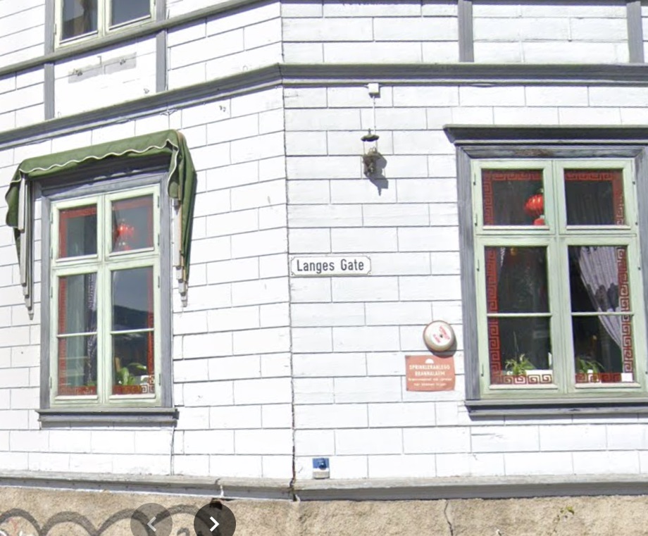
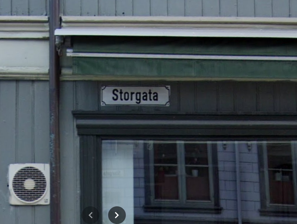
One of the places we visited was Trondheim, a lovely town right at the top of an enormous Fjord, next to an an enormous mountain; scale is a thing in Norway, and I’m sure these landmarks would be puddle and hillock respectively to the locals. We parked up a hill out of town and walked in, and as we approached a crossroads, my sherdy-sense tingled. No, not sherdy-sense, something else. And then I saw it… the road names. We were walking down “Langes Gate“, and we had just crossed “Storgata“, and before I knew what was afoot, my brain had forced out a mighty “what ho!” which might have alarmed the natives somewhat.
I recognised the word ‘gate‘ or ‘gata‘ from British placenames. Scandinavian in origin, meaning street or road, locally it can be found in Doctors Gate and Redgate, and this reminded me of a pet theory of mine, and I began to hastily scribble words down back in the campervan that evening, a glass of stuff that (expensively) cheers clasped firmly in hand.
Of those Domesday placenames I looked at, one really stuck in my mind, niggling with possibility. Truthfully, sometimes these things do, and I don’t know why; they shimmer and make a noise in my head, drawing attention to themselves more than others – I assume it’s my brain making connections, rather than an objective noise, but you never know… and once again, I feel I have overshared!)
Simmondley. First mentioned in the Forest Proceedings of 1285 as ‘Simundesleg‘, and then later as Simondeslee, the origin of the name is “the clearing (or ley/legh) in the forest belonging to a man named Sigemund (Old English) or Sigmundr (Scandinavian [Viking]): Simmondley. Ok then, so we have a possible ‘Viking’ name, but there is no evidence for Vikings hereabouts. Or is there? And this is where is started to get interesting.
The Vikings – and all manner of Scandinavian folk – first began raiding the coastlines of England en masse at the start of the 9th century. Eventually, the raiding stopped, and it became a steady flow of immigration, settlement, and farming – swords to ploughshares, and all that. It’s a big country, there was a lot of land, and so they stuck around, and in doing so they changed not only the language we use, but also the placenames of the area they settled – in particular, the area that became known as Danelaw – where they were allowed to keep following their own laws as long as they were loyal to English (Saxon) kings. The exact limits of Danelaw is a bit of an unknown, but it roughly stretched from Essex to Northumbria, and across to the Mersey – this is lifted from the Wikipedia page, and Danelaw is in red.
As you can see, whilst we are on the border, we Peak Sitters are still within Anglo Saxon (English) controlled lands, hence we don’t have many Scandinavian placename elements hereabouts, those name endings such as –thorpe –holme, –by, and -ton that are common enough just over in West Yorkshire, but not at all here. It has been suggested that the limit of Danelaw, whilst flexible, may have been the River Etherow and Derwent Valley, making us very much at the limit of Saxon land (If you are really interested, the always excellent before1066 blog has a great read about the Danelaw in our part of the world – you can read it here). But this area is firmly Saxon in language, and thus in placename.
Or so it seemed… and here it gets speculative.
Whilst the area was never settled properly, Sidebottom notes that a small number of areas in the Peak District have Norse derived placenames in their landscape, perhaps indicating the presence of settlers (Monyash, for example). These, he suggests, are Hiberno-Norse settlers – in essence, Vikings who had settled in Ireland, but were expelled from there in the early 10th century and settled in the area around Chester and the Wirral. From here, they moved east and were allowed land to the east of Manchester, specifically in the marginal western slopes of the Pennines. Hmmm… east of Manchester, in the slopes of the Pennines…. does that description sound familiar? Yeah, it rang a bell with me.
These were not true Vikings, and were actually 2nd or 3rd generation immigrants, but they would have spoken their language, and whilst they might not have named any existing settlements as such, they used their dialect words to name the elements of the landscape, and these don’t often change.
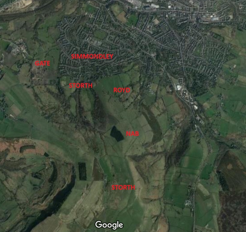
It was the origin of the placename Simmondley that initially rang the bell of possibility. It is first mentioned in the Forest Proceedings of 1285 as ‘Simundesleg‘, and then later as Simondeslee. The meaning of the name is “the clearing (or ley/legh) in the forest belonging to a man named Sigemund (an Old English name) or Sigmundr (a Norse name): Sigemund’s Legh = Simmondley. We assume it’s Saxon, because there are no Norsemen around here… but what if there were? And then the second bell was rung in Trondheim… Gate. In the Simmondley area, this is found as part of Hargate (as in Hargate Hill), but are there any other placenames of Norse origin in the Simmondley area, I wondered?… and promptly disappeared down a rabbit hole that I’m still not sure I have come out of!
So then, there are six Norse placename elements that occur in the Simmondley area:
Simmondley itself, we have already discussed, but its possible meaning is the ‘clearing in the woods belonging to Sigmundr‘. Sigmundr, and presumably his family, may well have arrived from Cheshire way, and cleared a smallholding in the woodland, where he would have set about naming things in his native tongue! Interestingly, Simmondley isn’t in the Domesday survey, possibly because it was simply a farm and too small to be recorded as its own settlement, so was just recorded under Charlesworth generally. We also need to realise that it may have only been in existence for 100 years in 1086, possibly even less.
Sitch – here used in Sitch Farm on Monks Road directly up from Simmondley. Sitch is derived from Old Norse ‘Sik‘ meaning a small stream, especially those flowing through flatland and marshy areas. It occurs elsewhere in Glossop: Wall Sitch by St James’ Church (discussed here), and Back Sitch, a footpath in Old Glossop.
Nab – here used in Whitley Nab. It is derived from the Old Norse ‘Nabbr‘ meaning a projecting peak or hill, which sums up the Nab perfectly. The Whitley (or Whiteley) part is presumably referring to a clearing; white here meaning without colour.
Royd – here used in Hobroyd. The word – meaning clearing – is not exclusively Norse, as it is found in Saxon places too: the root is the same for both German and Norse. But it is often used as evidence for Norse influence when found with other Norse placenames. Interestingly, the word ‘Hob’ here means a hobgoblin or other supernatural creature; Hobroyd is the ‘clearing belonging to the goblin‘. Bizarre.
Storth – here found in Storth Brook Farm and the adjacent Storth Brow Farm. The word Storth is Old Norse and means a young wood or plantation, possibly one planted.
Gate – here found in Hargate Hill Farm. Gate, from the Norse, Gata, meaning road.
This last one, the one that started this whole merry dance, is for me the cherry on the cake, and what just about convinces me. It gets its first mention as Hargatt in 1623 in the burial record of Widow Robinson. Now, 1623 is 650 years after the time we are talking about, but placenames stick around, and rarely change; this is why we call Glossop, Glossop: some 1000+ years ago, someone described the area as “oh, you know, Glott’s Hop“… and here we all are, on this website. Perhaps more importantly, church records only go back to 1620 in Glossop – very very late, but not uncommon, so 1623 is only the first mention we have, not when the place spring into being. ‘Gate’ makes sense, but the ‘Har’ element makes little sense, until we find in 1664 it is referred to as ‘Hardgate‘, and we see that this is probably the ‘correct’ name, and that all others are variants of this – the ‘d‘ being an obvious sound to drop.
This got me thinking: Hardgate… Hard Road? And then I realised that the Roman Road from Buxton passes through the area just west of the settlement. Was Hardgate referring to the ‘Hard Road’ of the only decent road in the area, a beautifully built and ‘hard’ surfaced Roman Road, as opposed to the muddy nightmare tracks that the rest of the area was filled with, and which even in the early 1800’s were still being moaned about? I wondered about the word Hard, and on a whim I entered the English word into Google Translate. Do you know what the Norwegian word for ‘hard‘, meaning solid or inflexible is?
‘Hard‘.
Hargate/Hardgate simply means the ‘Hard Road’ in Norwegian. I am convinced this refers to the Roman Road in their native tongue, and that convinces me that this whole ‘Viking’ enclave in Simmondley is a real thing. At least, I’m convinced… for now; I realise I’m not a placename specialist, and that this is something of a stretch. But c’mon…
Location of the placenames
So the next time you are in the Co-Op buying beans and some bread, remember: “We Gardena in geardagum, þeodcyninga, þrym gefrunon, hu ða æþelingas ellen fremedon…” and all that!
Ok, so, I can already hear the army of linguists and placename specialists lighting torches and starting to yell. Truthfully, I’m out of my depth here, but I believe what I’ve written. If you know better, please let me know… I’m always happy to be wrong, as it’s how we learn. But more importantly, if you know of any other Norse placenames in the Simmondley area, please let me know. Part 2 of this post – coming soon – is even more contentious! And in between – probably – is another instalment of the Rough Guide to Pottery… I know you have missed it so. Although the screaming I’m hearing (and swearing… don’t think I can’t hear that too) is a little off-putting. But in l know you are only joking, so as a reward, I’ll put in extra photographs.
Until then, though, look after yourselves and each other, and until next time, I remain.
I’ll not beat about the bush, let’s get straight to business! Over the past few months, when I had time, I spent some entertaining hours poring over any and all parish and other records relating to Glossop. Not just that, but estate records, royal tax records, and wills too… anything with a place and a date, essentially. I have been trying to establish the first mention of the farms and places that make up what we know as Glossop in order to get a feel for the place in the 16th, 17th, and 18th centuries. Why yes, yes I am that interesting.
Parish records were first introduced by law on 5th September 1538. From that point on the details of any event that took place within the church had to be recorded, and thus anyone baptised, married, or buried (hatched, matched, or despatched) were entered into a ledger (here is a good introduction to the subject). The details depended on the event, but it usually included a name, a date, and, crucially for us, a place: e.g. 14th June 1620, Jonah Wagstaffe, son of Charles and Elizabeth of Glossop, was buried.
What follows is an alphabetised list of the locations mentioned in the parish records for Glossop All Saints parish church in Old Glossop. I primarily used the North West Derbyshire Sources site, run by the seemingly unstoppable Marjorie Ward. The website is an absolute goldmine of data for this area, so please do check it out. Also, all credit, and huge thanks, goes to the people who originally transcribed the parish records; it wasn’t me, and all I did was read them and extract some information – I merely stood on the shoulders of giants, to quote Newton (and others).
Glossop’s records don’t go back as far as 1538, sadly, but instead start in 1620. Why this should be is unclear, but it is not the only example from around the country; opposition to the process, a lack of direction, and simple laziness may all have played a part. Because of this, I also looked at any other forms of official records I could find – tax records, wills, land deeds, and what not, to see if I could push some dates back further. I will be adding to these data in future, especially as I come across earlier references to places, so think of this as a work in progress. I have used the modern spelling for the places, but have made a note of different spellings when they appear. Until relatively recently, there was no standardised spelling of words, and placenames in particular were spelled how they sounded, often reflecting the accent of the people, as is the case here (see Coombes and The Heath for good examples of a local accent preserved in the records).
Note that this is simply the first mention of these places, not the date they were founded. This may seem obvious, but it is important to state that many of these places will have been settled for hundreds of years prior to their mention in the Parish Records. This is underlined by looking at how many of the entries have a date of within 20 years of the 1620 commencement of the parish records – it is clear that they didn’t all just pop into existence at that point, and that the first mention of them here is just that. A big boom in the settlement of the area would have commenced in the 1530’s after Glossodale was taken from Basingwerke Abbey and given to the Talbot family – it would be in their interests to get as many rent paying farmers on the land as possible. That stated, the abbey was pretty good at making money and would certainly have encouraged the foundation of farmsteads, thus we can perhaps characterise the period following the relaxation of the forest laws as one of continual expansion.
A note on the sources: PR – Parish Records. Domesday Book – is fairly self explanatory. 1381 Poll Tax – information taken from the book ‘The Poll Taxes of 1377, 1379, and 1381’ by Carolyn Fennick (Glossop only features in the 1381 Poll Tax, oddly). Wills – from the North West Derbyshire Resources website. Kirk – papers of the Kirk family of Glossop and Chapel-en-le-Frith. Datestone – the datestone on the house. EPNS – any of the numerous records used in ‘The Place-Names of Derbyshire Vol. 1’ published by the EPNS. EPNS – Ch – is ‘The Place-Names of Cheshire Vol.1‘. Derbyshire Subsidy Roll 1327-8 (DAJ) – Another poll tax, published in the Derbyshire Archaeological Journal of 1908 (read it here, if you like). Roll of Fines – a list of people fined for offences against the forest, and dated to the 13th year of Edward I (1285), you can read it here (it’s the same source as the Forest Rolls (EPNS), but I have mined some more information that the EPNS left out). Shepherd’s Society – the list of members of that society that met in Glossop and Longdendale (read it here). Shrewsbury Papers – the public record office collection of the Earls of Shrewsbury’s papers (the Talbot family archive, essentially) – here.
Place
Date
Person Named
Notes & Alternate Spellings
Source
Almans Heath
1650 (22/7)
Burial of Elizabeth Timplie, widow
“Almens Heath”
PR
Ashes
1674 (12/11)
Marriage of William Newton & Mary Newton
PR
Bank
1668
Bank Farm on ‘The Bonk’
Unpublished Ryland’s Charters (EPNS)
Bankwood
1717
Hadfield. “The Bankwood” (Gate) (Bankswood)
Rylands Charters (EPNS)
Bettenhill
1637 (24/3)
Burial of Elizabeth Robinson, wife of Robert
“Betterside Hill” “Betterside the Hill” “Bettinside Hill”
PR
Blackshaw
1600
Will of Ottiwell Beard of Kynder (John Dande of Blackshaw is witness)
Wills. Also the burial of Anna Dande, wife of John 1621 (PR)
Bridgend
1598
Will of William Barber of The Heath (Robert Bramhall of Bridgend is witness)
“Bridgent”
Wills. Also, Burial of Ann Brammall 1654 (PR)
Brown Hill
1285
“Brunhill”
Forest Rolls (EPNS). I’m not convinced, to be honest – Brownhill is a common name, & the physical evidence does not support 1285. Reference to “Sarah Hollinworth alias Brownehill” in 1624 might be this place. Definitely, though, Thomas Garside in 1807 in SS
Castle Hill
1692 (2/2)
Burial of Edward Hadfield (snr)
PR
Charlesworth
1086
“Cheuenwrde”
Domesday Book
Chunal
1086
“Ceolhal”
Domesday Book
Cold Harbour
1627 (23/5)
Marriage of Otwell Clayton & Margaret Downes
PR
Coombes
1285
“Chiselwrthecumbes” (1285), “Cowmbes”
Forest Rolls (EPNS). Also baptism of Anna Bridge, daughter of John 1644 (PR)
Coombes Edge
1700
Burial of Elizabeth Booth
“Colmes Edge” Same as Cown Edge below?
PR
Cow Brook
1643 (24/3)
Baptism of Joshua Dewsnap
PR
Cown Edge?
1702
Baptism of Sarah Booth
“Cold Edge” “Coln Edge”
PR
Crosscliffe
1555
Edmund Bower of Whitfield
Lease in DRO (D5236/5/27) Also 1608 Calendar Rolls (EPNS)
Deep Clough
1285
“Depecloxe” “Dupecloh”
Forest Rolls (EPNS). Also baptism of Nicholas Brammall 1620 (PR)
Dinting
1086
“Dentinc” (1086), “Dintinge”
Domesday Book.
Fieldhead
1804
Will of George Roberts (mentioned land at ‘Field Heads’ – presumably the same)
The position of Fieldhead Farm is literally that, at the head of the ploughed selions, now simply fields.
Wills. Also will of Jacob Hollingworth 1845
Gamesley
1285
“Gameleslegh”
Forest Rolls (EPNS). Also Tax of Jurdan de Gamesley Derbyshire Subsidy Roll 1327-8 (DAJ)
Glossop
1086
Domesday Book
Hadfield
1086
Domesday Book
Hargate Hill
1623 (10/7)
Burial of Widow Robinson
“Hargatt Hill” “Hargett Hill” “Hardgate Hill (1654)” “Hardgate” might refer to a ‘Hard Road’, i.e. not muddy track. Roman? The road does pass by here.
PR
Heath
1285
John del Heath
Also as “Teathe” (3/11/1658) (PR)
Roll of Fines. Also Robert del Heth, Derbyshire Subsidy Roll 1327-8 (DAJ)
Herod Farm
1703
Datestone
Hilltop
1679 (27/7)
Burial of John Hadfield
Caution… there is also a Hill Top in Chisworth (EPNS).
PR
Hobroyd
1327
Wills de Holberode
“Hob Road” “Hobrod” – road rather than royd?
Derbyshire Subsidy Roll 1327-8 (DAJ)
Hollinworth Head
1546
Hollingworth Head Farm
Unpublished documents in the Middleton Collection (EPNS). Also burial of Emmot Taylor, wife of Ralph 1623 (PR)
Hurst
1550
“Whitfield Hurst”
Feet of Fines (EPNS). Also baptism of Robert Hagh in 1621 (PR)
Hurstnook Farm
1772
Datestone
Jumble
1640 (1/4)
Burial of Grace Turner, wife of Reginald
“Jomble”
PR
Lamyclough
1629 (8/12)
Burial of William Newton, son of Hugo
“Lammanclough” & “Lammeclough” – Charlesworth way
PR
Lane Ends
1623 (14/12)
Burial of John Robinson
Whitfield
PR
Laneside
1625 (14/9)
Burial of John Bramall
PR
Lee Head
1706 (12/1)
Burial of Thomas Harrison
Charlesworth
PR
Lees Hall
1285
Jo. de Legh (of Whitfield) (John de Legh)
Also Ricardus del Lees 1381 Poll Tax
Little Padfield
1711 (5/1)
Baptism of Elizabeth Creswick
PR
Long Lane
1696 (24/6)
Burial of ‘Old Widow’ Boedon
Charlesworth
PR
Long Lee
1621 (17/9)
Burial of George Hyde
PR
Mill Town
1643 (27/6)
Burial of Margaret Mellor, wife of Ralph
PR
Monk’s Road
1290
“le Cauce” (The Causeway)
Calendar of Charter Rolls (EPNS)
Moorside
1616
Will of Thomas Hollingworth of Moorside.
This may be Moorside in Chisworth, confusingly.
Wills. Also burial of Widow Hollinworth 1623 (PR)
Moregate
1655 (2/4)
Baptism of Helena Hadfield
Hadfield
PR
Mossy Lea
1623 (5/1)
Burial of Ellina Hollinworth
“Mosseley” & “Moselee”
PR
Mouselow
1628 (16/11)
Baptism of William Newton
PR
Over Deep Clough
1709 (19/1)
Burial of Henry Hadfield
PR
Padfield
1086
Padefeld
Domesday Book
Pike’s Farm
1780
Datestone
Priest’s Pastures
1616
Petition to the King by a “Nicholas Hatfielde”
“Prist Pasters” – Padfield somewhere.
Shrewsbury Papers, Folio 147 (no date, but the recipient, Gilbert, died in 1616, so before then). Also 1640 (20/2) – Baptism of Anna Hadfield (PR)
Pyegrove
1631 (15/1)
Burial of Anna Booth, daughter of Ralph & Anna
“Pigreave” “Pyegreave”
PR
Reaps Farm
1631
Burial of William Hadfield, son of William & Helen
“Reape”
PR
Ringstones
1623 (13/5)
Baptism of Thomas Roobotham
PR
Rowarth
1285
Roger le Ragged de Roworth
“Rouworth”
Roll of Fines. Also Burial of Elizabeth Goddard, wife of Robert 1626 (PR)
Shaw
1285
Mathew del Shawe
Roll of Fines. Also Henricus del Schawe 1381 Poll Tax
Shelf
1285
Possible location of Monastic Grange?
Forest Rolls (EPNS).
Shire Hill
1285
“Shyrhull”
Forest Rolls (EPNS).
Simmondley
1285
Alward de Symondesly
“Symondlee”
Roll of Fines. Also Burial of Joanna Beelee, w. of William 1620 (PR)
Spire Hollin
1700
“Spire Hollin estates” mentioned for sale in D513/M/E/374 with others.
Kirk Estate Papers #374. Also 1734 Poll of Derbyshire (EPNS)
Storth
1578
Harry Booth of Storth Farm, Simmondley
He had dispute with Lord Talbot & went to London to see Queen Elizabeth I.
Historical record. Also Baptism of Joseph Botham, son of Henry & Mary, 1638 (PR)
Calendar of Inquisitions Miscellaneous (EPNS). Also baptism of Joseph Bramall 1628 (PR)
Woodhead
1424
Cholmondley Deeds (EPNS – Ch). Also baptism of Anna Bostocke 1629 (PR)
Woodshead
1654 (13/9)
Baptism of Elizabeth Heawart
“Woodsheds” in Charlesworth
PR
Wooley (Bridge)
1286
Court Rolls (EPNS – Ch)
And there we have it. Obviously buildings within these areas will have separate dates, but overall we can begin to picture Glossop as it was in the medieval and post medieval period.
Visually then, it looks like this:
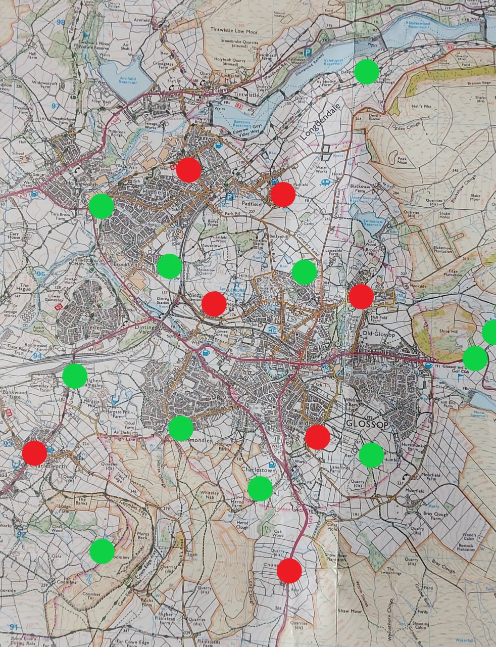
This is the situation at Domesday – 1086 – with all the names villages marked in red.
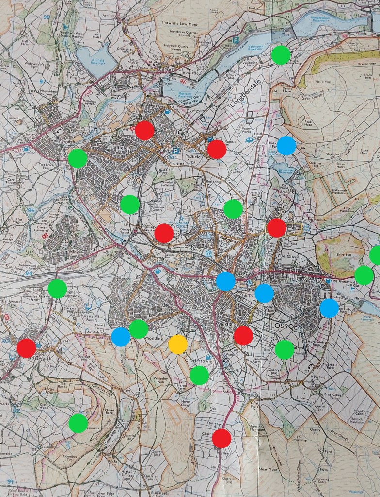
By 1285, Glossop looked like this:
The monks of Basingwerk have it, renting it to the Talbot family who are encouraging people to farm, making money for themselves in rent and produce.
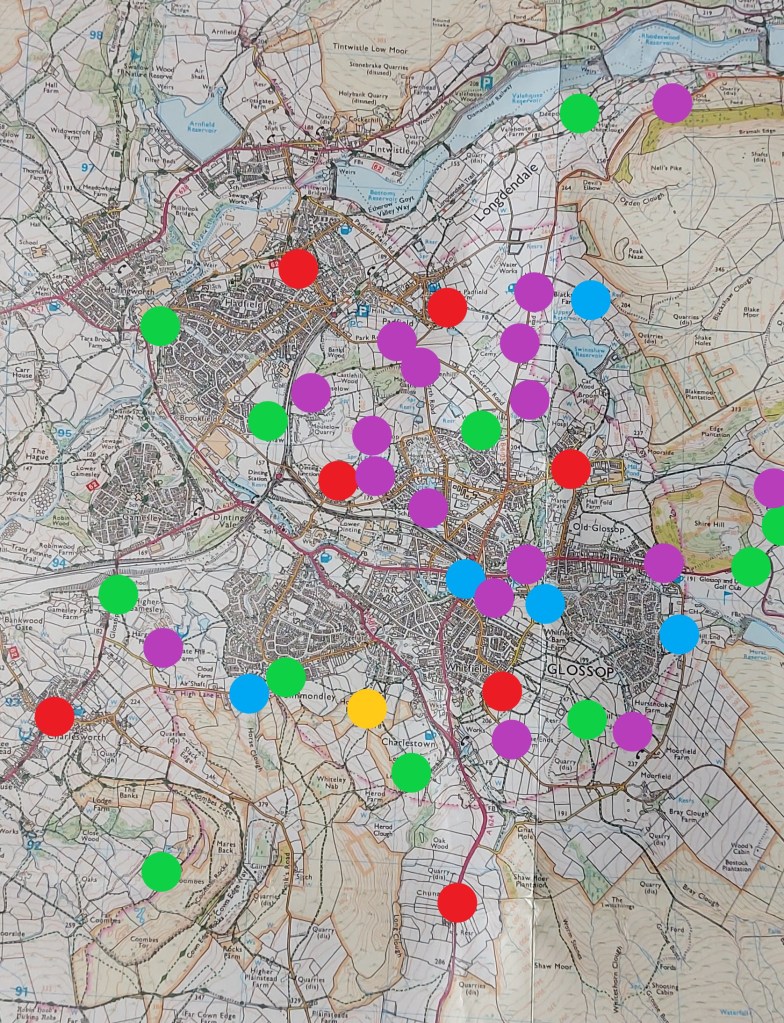
By 1450, very little has changed:
Just Hobroyd Farm has been added.
Following the Dissolution of the Monasteries from 1538 onwards, the land becomes the sole property of the Talbots who continue to encourage the founding of farms. Here is the situation by 1620:
The area is becoming filled in.
100 years later, the land is full of smaller farms, all paying rent to the landords, now the Howard family. The explosion in farms may be connected to the Howards drawing up longer rental leases, allowing people to invest in buildings and land not just for themselves, but for their children and grandchildren. Here is the situation in 1720:
Obviously, this is a very broad study – I just want to get the information out there. There is an awful lot more that could be done here, not least of which could be some form of more formal survey of the land deeds. It should also be pointed out that many farms will have disappeared over time, forgotten about or subsumed by larger farms, and what we have here is not a 100% accurate reflection of Glossop, merely a snapshot.
More research is needed indeed… but for now, I’m going to have a snifter of the stuff that cheers.
Right-ho, that’s your lot for this time. Next time I promise more pottery… I know how much you’ve missed it. Until then, take care of yourselves and each other.
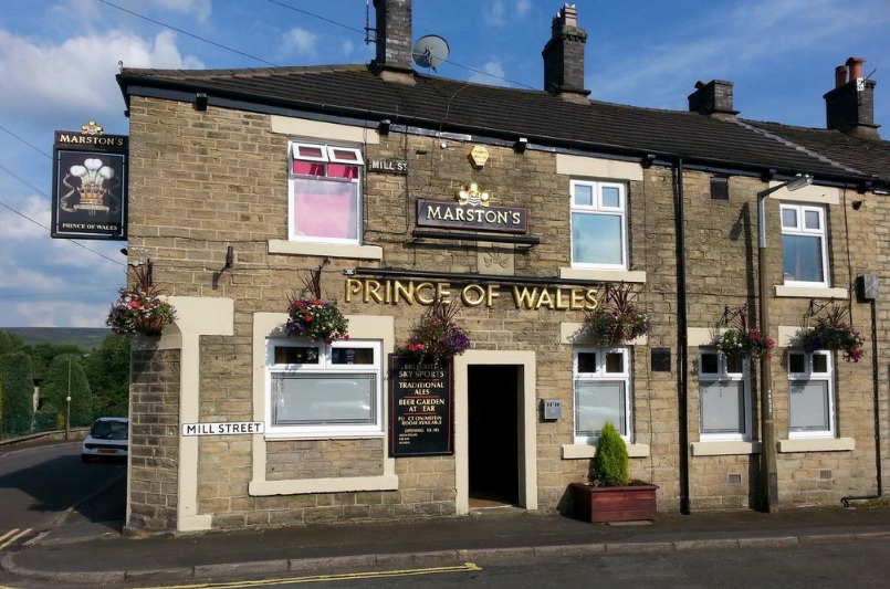
I went for a pint with my father in law a few weeks ago (hello Mr B!) in what has become a bit of a Wednesday evening post-work ritual for us. We popped to the Prince of Wales in Milltown which, I am reliably informed, was built in 1852. And an excellent pub it is too – good beer, and a great beer garden. It has a real sense of history about it, especially as the area is now being developed so heavily, and I would imagine that it would have been a bustling pub, rowdy and rough, in the 1800’s.
I love the corner door, now bricked up – probably the entrance to the tap room – and the carved ‘Fleur de Lis’ (traditionally the symbol of the Prince of Wales) above the door is a nice feature. Also, note the Victorian street sign for Mill Street to the left of the Marston’s sign. Fascinating.
Sitting drinking my beer and chatting, I had a look around to see if I could see anything of interest, and lo! In the flower bed amongst some more modern glass and pottery, were these beauties:
Clay pipes – the cigarette butt of the Victorian Period.
I love clay pipes, I really do. There is something so tactile about them, and so personal too. I joke about them being the cigarette butt of the Victorian period, and they are in a sense – smoke them and then throw them away – but they embody so much more. Believe it or not, they are the subject of many very detailed archaeological studies; they are mass produced, but they show features that shift over time, allowing a fairly precise date to be given to the pipe, and possibly then to the site/building/feature. Google “clay pipe chronologies” for examples. I’m not going to go into too much detail, as I really am no expert, but these two examples are very obviously Victorian. The bit on the right is part of the stem, and comes from near the mouth-piece, as the stem get thicker nearer the bowl. The piece on the left has the stem, spur (that little bit the points downwards), and the lower part of the bowl, where the tobacco itself sits, and which in this case shows signs of burning. Neither are particularly interesting, and they are certainly not rare, but nevertheless are integral to the human story of Glossop, and one wonders what conversations were happening in the pub whilst they were being smoked?
The history of The Prince of Wales, and all other pubs of Glossop, past and present, are detailed in the excellent book ‘History in a Pint Pot’ by David Field. Meticulously researched and fascinating, it is highly recommended to anyone with an interest in the history of Glossop, pubs, or beer – so that’s all boxes ticked for me. It is now out of print, sadly, but Glossop library has a copy. You could also check out the superb Glossop Victorian Architectural Heritage website, they have lots of information about pubs, and much more besides. Well worth a look.
Moing on, this next pipe is a bit more interesting.
I found it a while back on the edge of my favourite path – Bank Street, or the ‘Bonk‘ as it’s known locally. However, not being born in Glossop, I would feel a fraud calling it the ‘Bonk‘, so Bank Street it is.
I love dialect words and phrases – the way that the beauty of the English language is tied firmly and absolutely to the place it is spoken is truly remarkable. American friends of mine marvel at how many accents there are in such a small island. And yet if we go back 100 or so years to a period before mass media, it would have been possible to tell not only which town you came from, but which part of the town, and indeed which street you lived on. Now that we are bombarded with accents and the media is dominated with southern ‘Estuarine‘ English, we are slowly becoming linguistically homogeneous and eventually we may lose our accents altogether, which I think would be a shame. What is interesting about ‘Bonk‘ as a word is that it not only partly reflects the Glossop accent, but it is also almost certainly derived from the medieval French ‘Banque‘ meaning a steep wooded valley next to a stream. It crops up in Cheshire dialect as ‘Bongs’, and the nearest examples I can think of is Leebangs Rocks in Broadbottom (Leebangs = Le Banques), and The Bongs both in Handforth, and in Goostrey. It’s not often you encounter Norman French in Glossop!
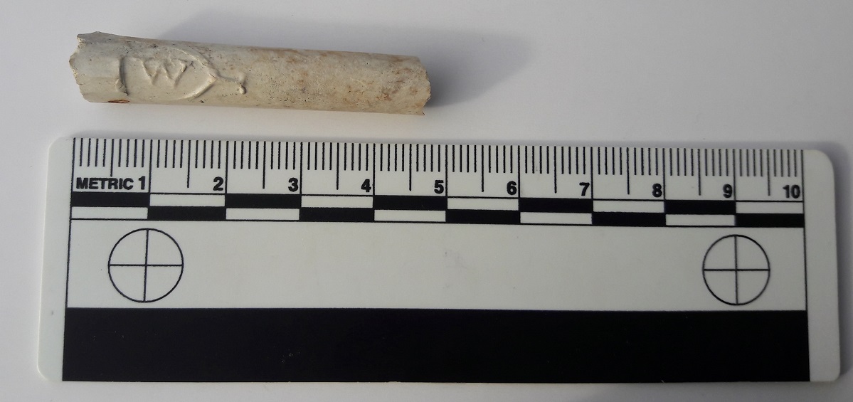
But I digress! It was found not too far from the bottle top I blogged about here. I thought it nothing particularly special until I got home and cleaned it. Wow!
Side 1 – ‘W’ Cartouche
Side 2 – ‘T’ Cartouche
It’s the front part of a clay pipe, just at the point where the stem meets the bowl – you can see it thickening into the bowl. But on either side, imprinted into it, is a cartouche containing the letter ‘T’ and letter ‘W’. Presumably these are maker’s marks, but unfortunately, I cannot find any information out about who or what ‘W’ and ‘T’ were. Also there is the suspicion that they may actually not be maker’s marks as such, but were instead used by many different companies as a way of suggesting quality – it was perceived by the buying public that those letters were associated with a superior pipe (I read this somewhere, and now can’t find the reference… grrrrrrr). This would be similar to the Victorian belief that pipes from Ireland were the best, and thus many clay pipes have the words ‘Dublin’ or ‘Ireland’, or have a harp or shamrock imprinted on them somewhere… despite being made in Birmingham or similar. It is Victorian in date, and scrubbed up quite nicely!
I was originally going to blog about this in a larger post about the trip down Bank Street (which I will still write… honest!), but it seemed to fit in here better.
By the way, if the landlord of the Prince of Wales reads this and wants the pipes back, I’ll bring them round next Wednesday!
EDITI found the reference to ‘TW’ – it was in the Clay Tobacco Pipes report by Dennis Gallagher, and from the High Morlaggan Project (the report is under excavation / reports / clay pipes). In it, it states that ‘TW’ pipes “were an extremely popular type and were produced by most makers. The meaning of the letters is unknown, although it may originally been used by the early 19th century Edinburgh maker, Thomas White, who was renowned for his high quality pipes“.