No, fear not, dear and gentle reader, I have not had some sort of ‘attack’, or a fit of the vapours, or conniptions, or a melancholic fever, nor indeed some form of ‘brain disorder’ resulting in a sharp dose of the ‘lah-lah-lahs’ (despite what some of you may think). I am tickety-boo; hunky dory; cock-a-hoop; and all is, in fact, distinctly oojah-cum-spiff… I am perfectly normal. Honestly, and all shall be revealed, so stick around.
What ho, wonderful folk, what ho! Spring is upon us: I have seen sweet blessed blossom on trees, and daffodils. Oh, daffodils! Now, if it can just stop raining for a minute or two, I might actually dance. But enough of this frivolity, let us look at some bench marks! Stop that moaning, you at the back… it’s unbecoming of a gentleman.
If you have spent any time on this website you will know that have covered Ordnance Survey bench marks before. Several times, in fact. And will also know that I love them with a passion. What on earth do you mean “obsessed” – I have an interest, that’s all. I can handle it. It’s not like I approach strangers and tell them all about benchmarks. Often. Well, not since the rather nasty court case and the restraining orders. Anyway, let’s move on. Swiftly.
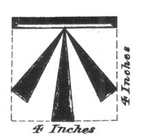
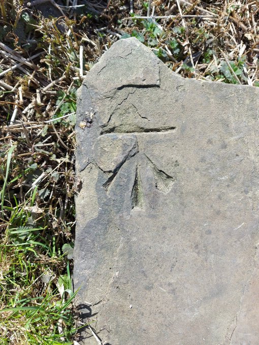
For those of you who don’t know (but dash it all, you should know), an Ordnance Survey benchmark is a mark carved onto a building or other immovable object that marks out a specific height above sea level. They are most often found as an arrow with a line above it:
The ‘broad arrow’ denoting British military ownership – Royal Ordnance – with a line on top.And here is one in real life – this one being precisely 682ft above sea level.
They are the remains of the original, and subsequent, surveys made by the Ordnance Survey in the 1840, allowing engineers and surveyors to record the whole country by height and distance. A remarkable feat, when you think about it: with each mark being intervisible with another, they are a literal network of heights, which, whilst visible in plain sight, is nonetheless overlooked or simply not known about by 99% of the population. I first encountered them whilst working as an archaeologist in the Oxford area where we used them to provide a height for the sites we were working on – essentially using an old fashioned level and ranging rod, we leapfrogged from the benchmark on a church to our site about a mile away, as this was the nearest benchmark, and we were working in the middle of nowhere! Benchmarks are marked on older OS maps, and they are found in their hundreds of thousands all over the country.
The system is no longer maintained, sadly, and they are falling into disrepair, but are much loved by nerds such as myself, who become, against their better judgement – and ignoring vague threats of divorce – Benchmark Baggers.
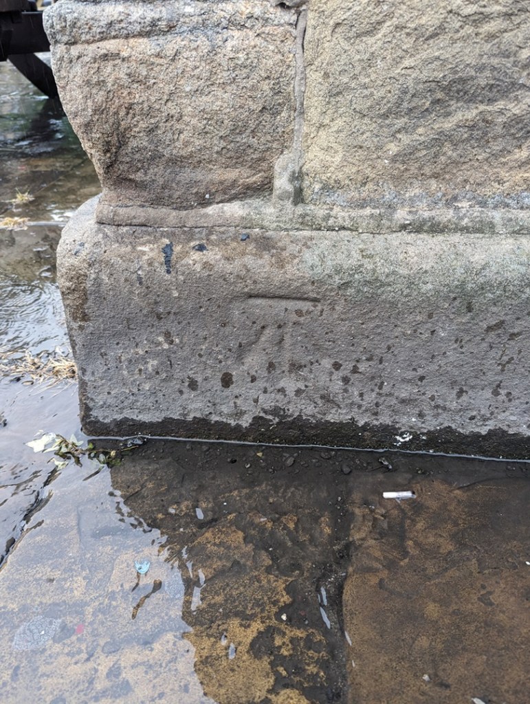
Now, occasionally, mistakes happen. The Ordnance Survey is very – painfully – good at what it does, but the people it serves – us – are not. Benchmarks go missing, or are moved, and sometimes too they are marked on buildings, but seem to have not been marked on maps. That is what this post is about – the anomalies and the oddities, not so much a benchmark… more a menchbark.
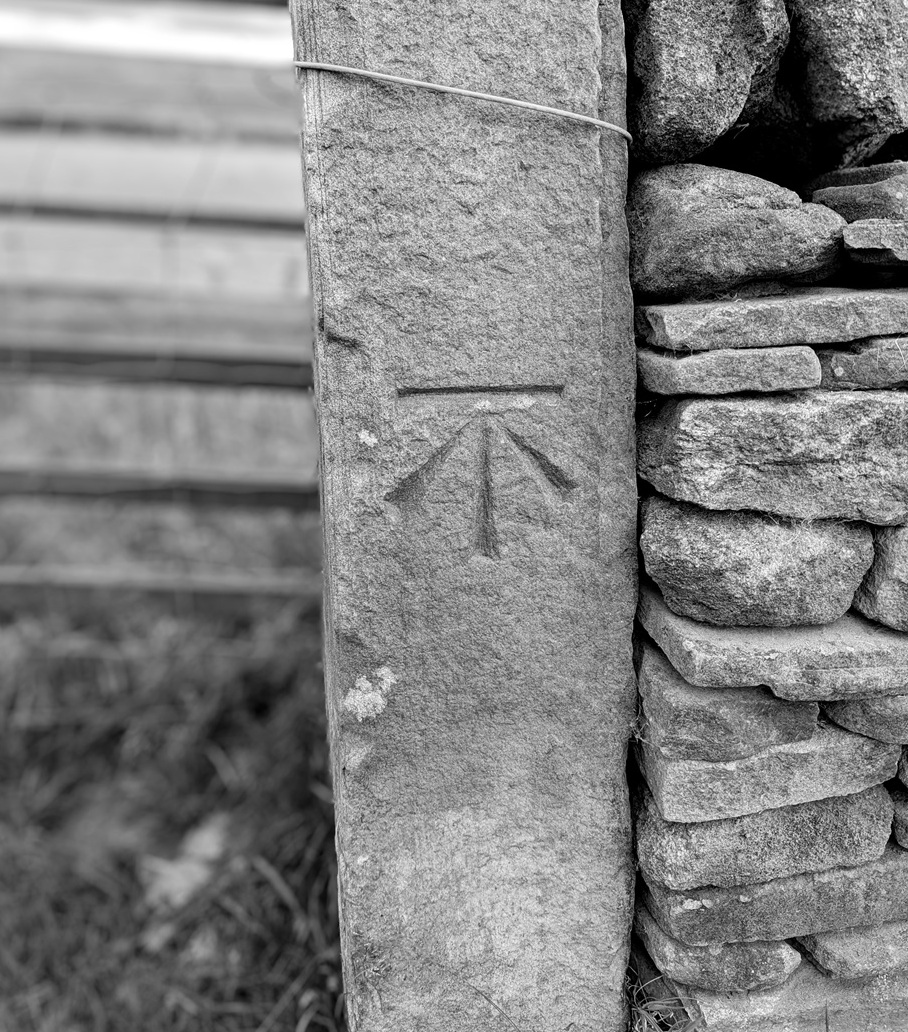
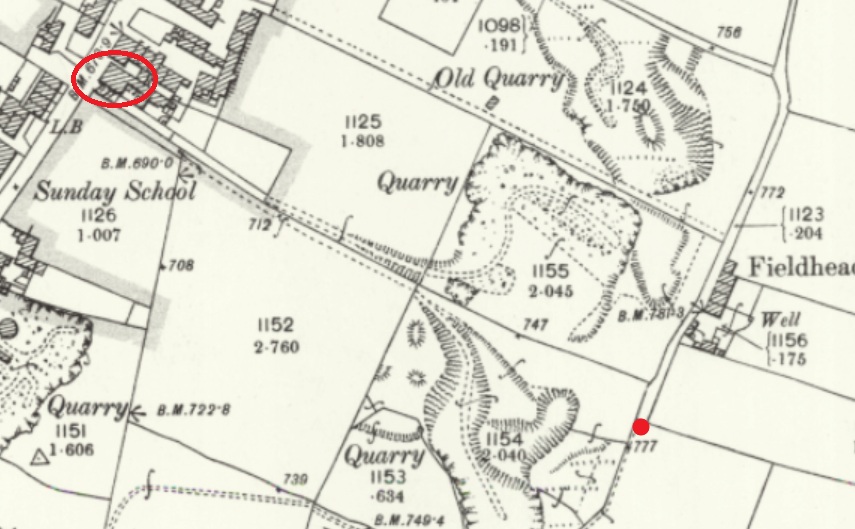
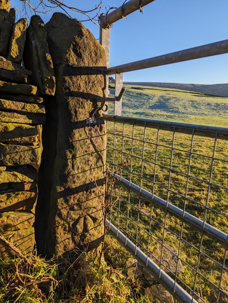
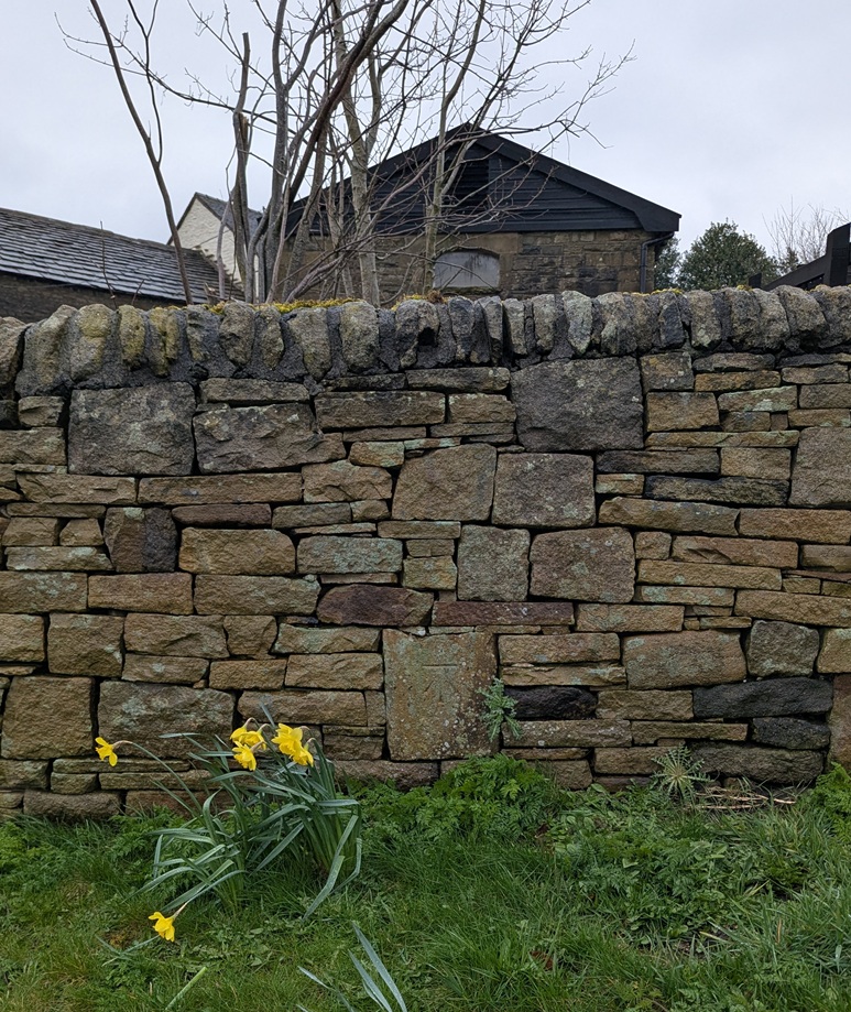
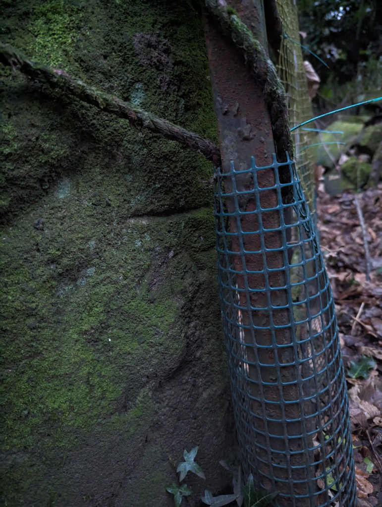
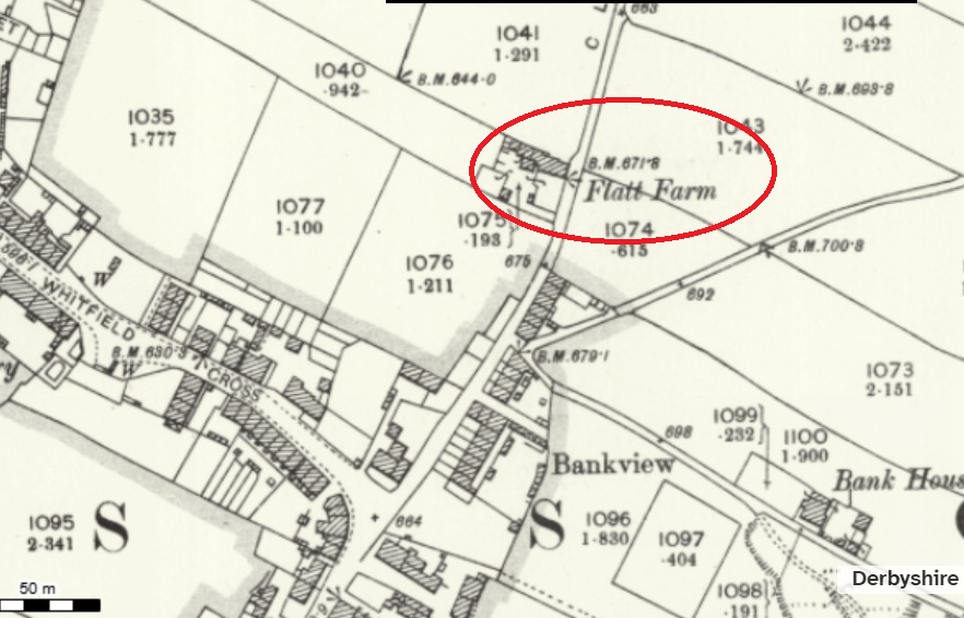
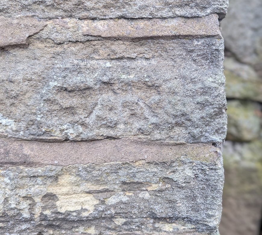
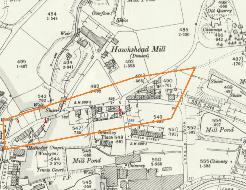
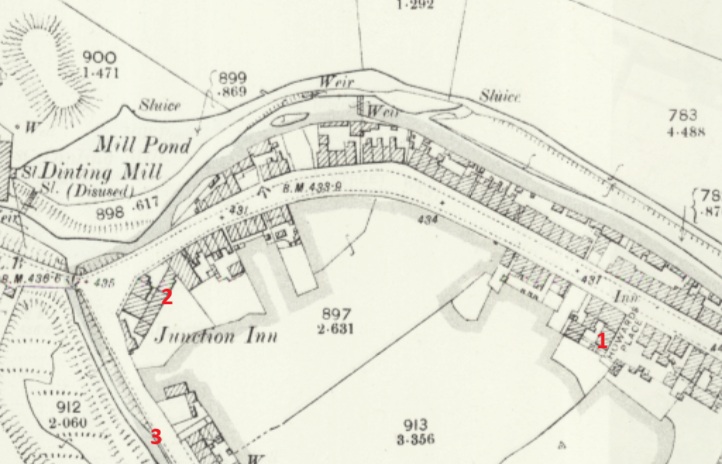
We start with Fieldhead Farm, Whitfield. The farm building itself has a benchmark, but nearby is a gatepost with a clearly carved benchmark on it; proudly stating the height above sea level of… we don’t know! It’s here on the map:
The Beehive pub is circled in red, for reference, but the benchmark is marked by the red dot.
There’s the mark, but the OS have never marked it on any map I’ve ever seen. And I don’t believe it has been moved from anywhere, either – that’s a solid piece of gatepost! Interestingly, it does replace a smaller square-holed medieval/post-medieval post. This is a very curious part of Whitfield that has a greater history than we currently understand – even the name ‘Fieldhead’ may suggest medieval origins.
Nearby, on Derbyshire Level is this lovely example:
This one was originally in the wall of the garden of Lane Ends Farm, Derbyshire Level. It still is in the wall, but the wall has been rebuilt fairly recently, and whilst it originally marked a height of exactly 705ft above sea level, and has been replaced in roughly the same place (amazing work, whoever did that), Jove alone knows what it marks now!
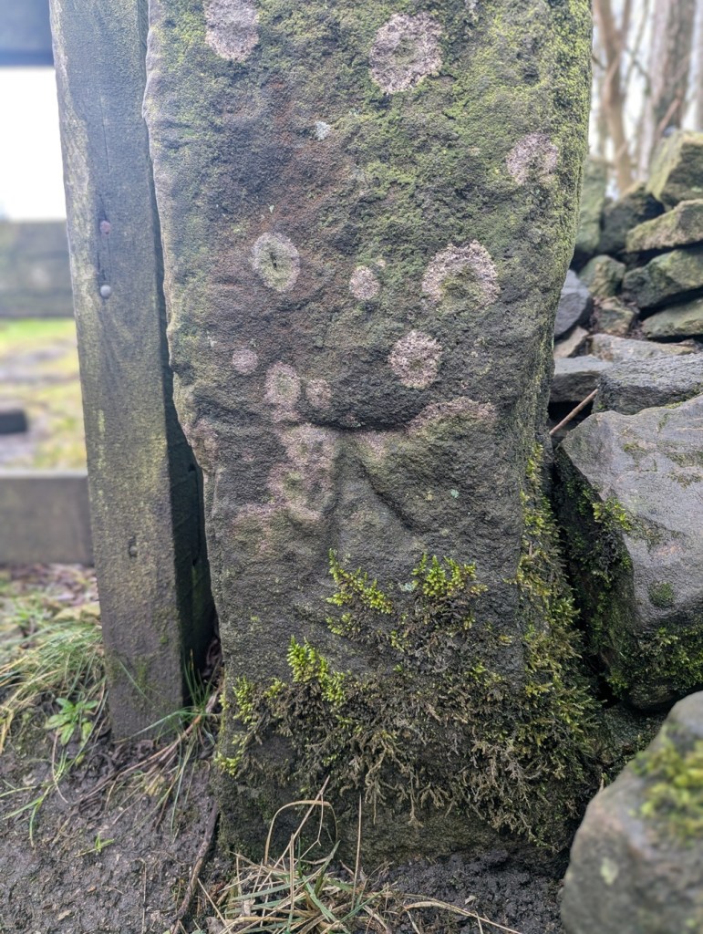
However, at least the people who rebuilt the wall understood that the benchmark had a purpose… and a right way up. Whoever rebuilt this wall in Hadfield – under the disused railway just by the start of the Longdendale Trail – had no idea what to do with it, so the benchmark was replaced upside down:
I mean to say… given that benchmarks for me represent an unmoving, permanent and fixed, point in a chaotic world (and mind), the sight of this inverted mark is literally turning my world upside down… and quite frankly gives me the heebie-jeebies.
Here, on the southernmost of a pair of paths between Hague Street and Charlestown Road (and discussed in this article), we see that sometimes the mark is moved, probably due to some form of destruction or movement. So in 1898, the mark is on an object to the south of the path (a gatepost that is no longer visible, perhaps):
At some stage, the mark is rendered useless, and by 1968 it’s moved to the north side, and carved onto a gatepost, itself no longer used:
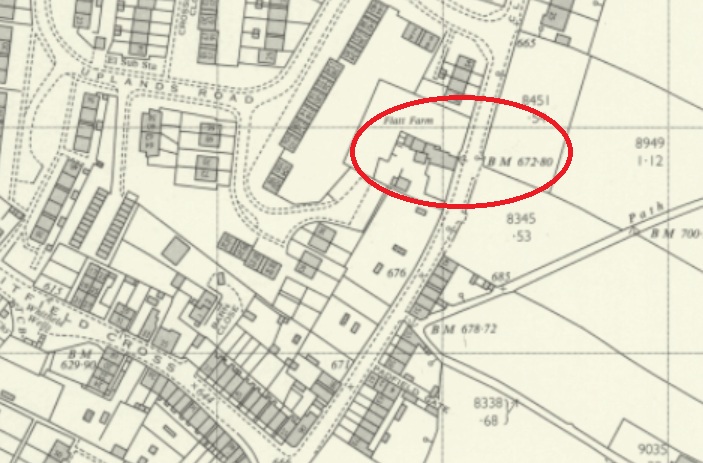
Next up, we have Flatt Farm, on Cliffe Road, Whitfield. The original benchmark is here:
1898 OS map
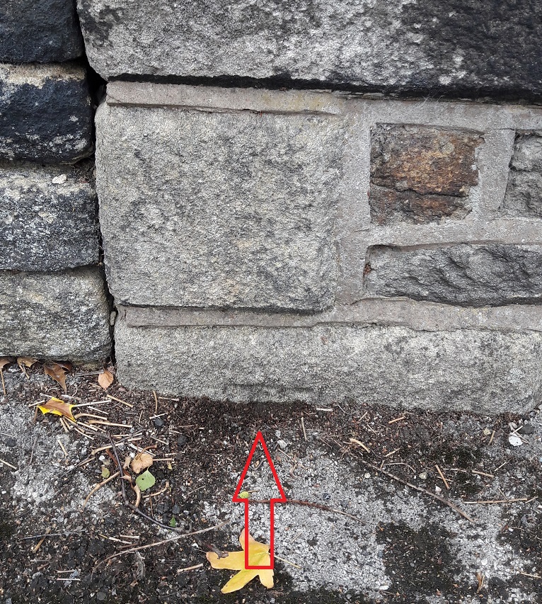
To the left of the building’s gable end. It is ridiculously low to the ground, with only the flat top showing – the result of the ground level having risen about 1ft.
As a result, a later benchmark was cut into the right-hand side of the gable end:
A lot has changed by 1969… including the benchmark locationWorn and faded, it is there in the centre of the photograph.
The ‘new’ carving was poor by comparison, and has faded quickly, a symptom, perhaps; by 1969, the whole system was falling into disuse, and benchmarks no longer were marked on OS maps as a general rule. Sad, but there you go. Of course, now we don’t use them at all due to GPS, etc. But I honestly think there is something grounding and wonderful about them.
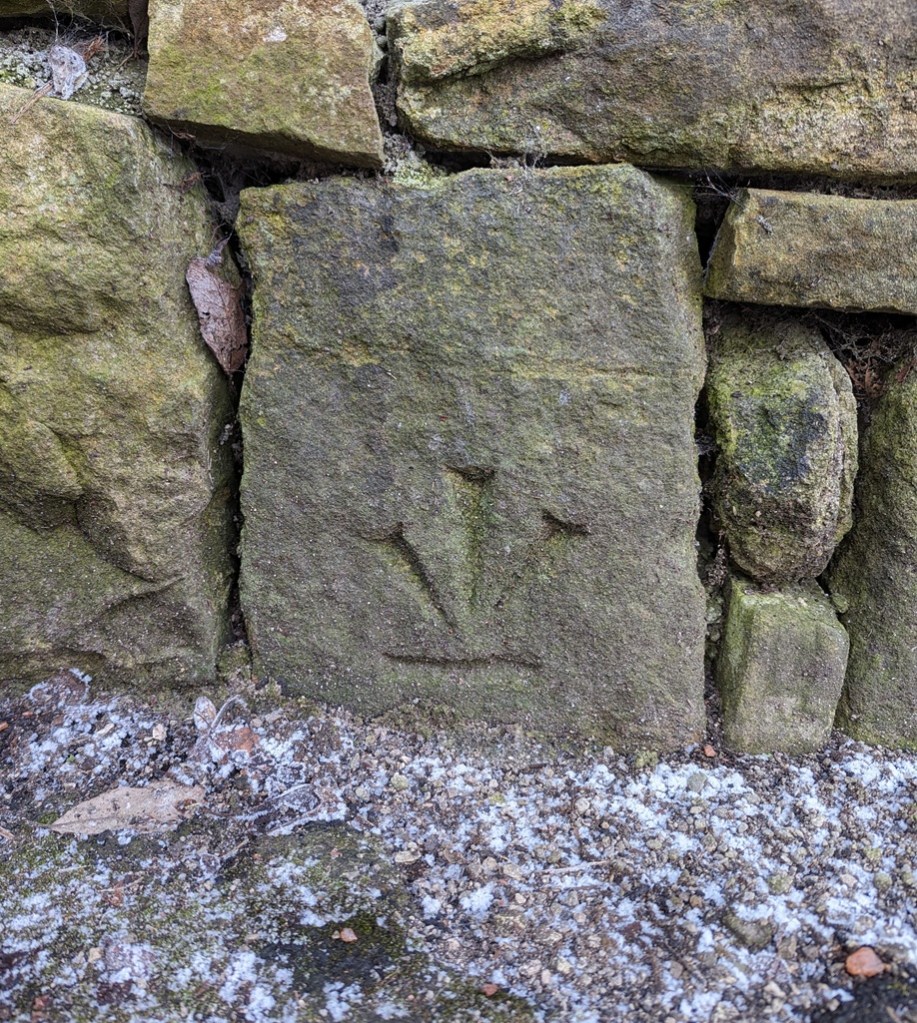
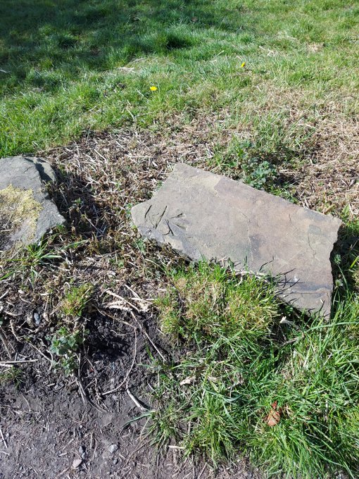
Anyway, whilst researching the latest Where/When (No.9), I discovered this wonderful specimen: potentially an abandoned attempt at a benchmark:
It’s at the right height – 1ft off the ground – and on the right sort of immovable object – a gatepost -and it would be in a perfect place for one, but it seems that during the carving process, a mistake was made – the stone may have crumbled, or a careless stroke was made, and the whole was abandoned. I might be wrong, of course, but that is what it looks like to me. You can have a look yourselves, here:
Facing the track to Far Slack farm, it’s the left hand gatepost (alos, right next to a rather spiffing holed gatepost, now lying on it’s side). The mark is also right by Robin Hood’s Picking Rods – a pair of 10th Century Anglo-Saxon Stone Cross shafts, and coincidentally, the stars of the latest Where/When – see below. Definitely worth checking out.
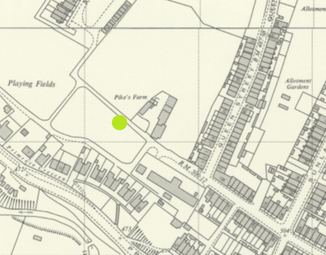
We’ll end on that most rare thing… a feral benchmark. Escaped from who knows where, it lurks, in a recumbent posture, and mocking all attempts at identification, just by Pikes Farm at the end of Pikes Lane. It’s been dumped from somewhere… but Jove knows where!
It was once on an upright gatepost, but is made from a non-local stone, so may have been brought from a distance. I contacted the OS, and they have no knowledge. A welcome visitor in our town, found here:
Left hand side of the track, just after Pikes Farm.
So there we go… interesting stuff. Well I like it, and I hope some of you like it too. Not you, Mr Shouty-Outy, we know, not you.
If you’re interested in benchmark bagging, I have recently begun using a phone app called TrigFindAR to help me find them. It has an almost complete map and database of benchmarks across the whole country, and allows you to tick them off as you find them (make them go from red to green) and to get onto the database kept at bench-marks.org.uk and look at that particular benchmark. I’m not sponsored – sadly – but it is truly a superb bit of kit, and is totally free; I cannot recommend it enough for you geeky types out there.
Elsewhere, the new edition of Where/When is out!
It’s an exploration of Cown Edge, Coombes Edge, medieval, prehistoric, and Roman archaeology, and a journey from The Beehive (Whitfield) to The Hare and Hounds (Simmondley). Essentially a guided walk around some really cool old stuff that starts and ends at a pub… what’s not to love. Think of it as a paper form of this website, but involving footpaths and loads to explore.
Available for £6.50 from the Where/When link above, or through the amazing Dark Peak Books and Gifts on High Street West, Glossop. Or just stop me and buy one!
Right, I’m off. I’m tired, grumpy, and am due a glass of the stuff that cheers any moment now. More soon, I promise, but until then, look after yourselves and each other. Please. We are all important, even if we don’t feel it sometimes. And until the next time, I remain.
What ho, wonderful folk! Apologies for not publishing something sooner than today… truthfully, I have been a little overwhelmed and burnt out. Recent events have caught up with me, and I’m tired and somewhat sore; nothing a breather couldn’t fix, but sometimes it all becomes a little too much – please do listen to your bodies and minds, as they will often steer you on a correct course. Anyhoo, I’m back, and happy to be so. So here we are, with a long overdue post.
Last March, I went on a little Wander with a friend and family (hello GW). We had set off to do the first Where/When Wander, but having kids with us, we ended up playing around in the land by the allotments and behind Dinting Station. Aside from the fact that the area is interesting from a historical perspective (being connected with Dinting Station, and filled with old bits and pieces), it was also the location of the old Dinting Railway Centre/Museum. I vaguely remember visiting the museum several times as a child, and I recently bought a vintage guidebook on Ebay to try and fully remember what it was I went to.
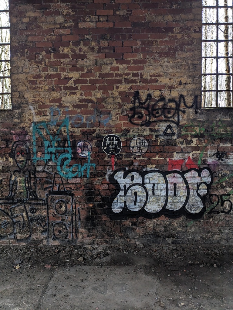
The centre finally closed in 1990, and whilst all the trains and exhibition pieces moved elsewhere, the infrastructure – rails, and platforms, and buildings – all remains (here is a good article about the museum’s rise and fall, and there’s loads about it on the internet). Central in this wasteland – or forest of Silver Birch – the Engine Shed still stands, alone, derelict, and graffiti covered.
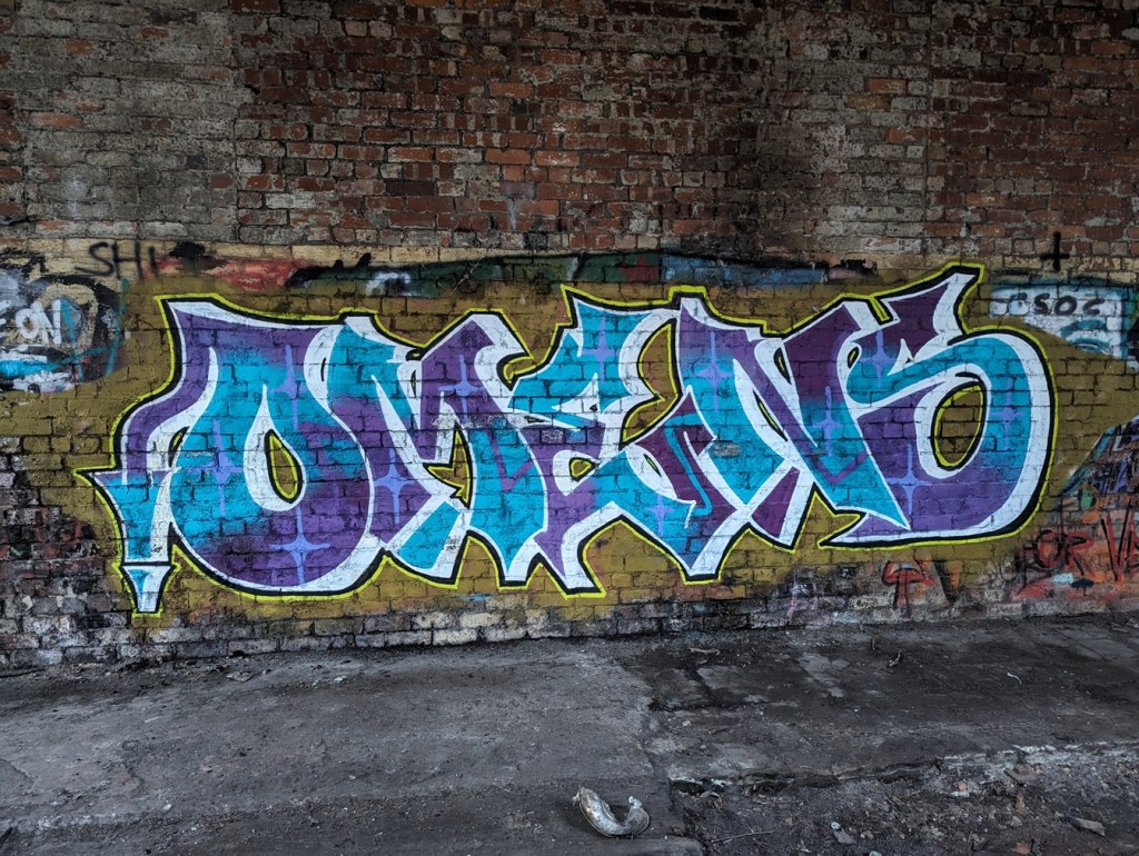
Here’s what it looked like in 1967, before the Railway Museum…And here’s a similar shot, nearly 60 years later, and after having been a museum in the meantime. Blimey! Honestly, the building is in there. Our old friend Boof makes an appearance, here represented by his/her older tag, and a newer (2025) bubble piece. His/her tag is all over the site.Some of it is quite good, this piece in particular ‘OMENS’ (strangely unsigned, presumably Omens is their ‘tag’), and this one……are very artfully done. Love the window in the background/part of of this one. So this is interesting. Because I am that sort of person, I knew this was something when I saw it. Rather bafflingly, this is the sigil of Foras, one of the 72 demons mentioned in the 17th century Lesser Key of Solomon. Apparently he was the president of Hell, and was associated with precious metals, logic, and lost things. Quite why his sigil is painted on the wall here is beyond me; teenage rebellion or demonic invasion? You decide.
Anyway, comparing the photographs of then with now is really quite interesting, and shows just how quickly nature retakes land back, even heavily used and industrialised land such as this. Give it another 100 years, and there will be very little recognisable, 500 years and it’ll need an archaeological excavation to make any sense of the site; understanding site formation processes like this is vital as an archaeologist, and our case study is right here.
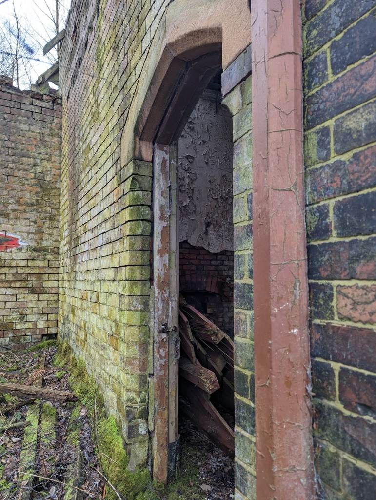
But today’s article is less about the centre, and more about a single aspect of the site. As generally happens, when a building is left derelict and unused, it slowly breaks down, and this is the case with Dinting station’s southern waiting room. Built in 1884, when the original 1848 station was rebuilt, you can see it from the train behind a fence; overgrown, derelict, absolutely terrifying. However, I didn’t know you could access the station from the back, via the patch of ground we were exploring. Well, I mean to say… one cannot simply say no when such gifts are presented to one! I had a brief explore! Brief because: a) I was probably trespassing, although it is very unclear to be honest (and I was by no means the only person there that day… or even that hour!), and b) we had children with us, and the place is phenomenally dangerous, with broken glass, falling masonry, and Jove knows what else. It was also going dark, and, I’m not going to lie to you, the place is spooky! Before we go on, I am also going to insert a cautionary statement here: I absolutely do not endorse you going to the place to look, and in fact recommend you don’t. So I took a very few, mostly terrible, photographs, and scarpered.
The station building from afar… the Silver Birch trees are amazing in this photo – and I actually find them frightening here. Random brickwork, and an odd framed shot of a corner with shamfered edged stone. Look, I had a quick look around, and then legged it! I wasn’t taking my time with perfection! Lovely Stoneware bottle; possibly a large ink bottle, but I suspect it is something more industrial – a chemical or oil, perhaps. The whole area is filled with burnt cinders and rubbish, amongst which are many interesting finds. It’s a beautiful building. Or at least could be. These windows are lovely, but then through them you can see sky through the roof. How long does this place have left before it all collapses? Who knows. The doorway, with what looks like a Cheshire sandstone lintel. I honestly feel something should be done about preserving this building. I don’t know what could be done with it, but something more than just leaving it to rot… surely?
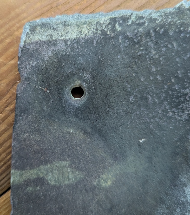
So I had a quick look around, as you do, and in doing so, I noticed that the whole roof of the exterior platform area had collapsed, seemingly as one, and the floor was littered with rotting wooden roofing and broken slates. And then I saw it… a single slate seemed to have survived intact-ish. I pulled it up and thought… I say, here’s a nice little blog entry! And so here we are:
Amazingly, it had both copper nails still in-situ, and whilst it has broken a little at the top, it allows us to see how it was made.
The rougher edges are very characteristic, and I think I can see the result of individual hammer blows. Possibly.
Geologically, slate is dense, and was laid down in thin layers, which allows us to quarry it and split it into relatively thin sheets using a hammer and chisel. It is further shaped using a soft hammer whilst over hanging a hard edge (or later using a machine, although still hand held). There is a fascinating YouTube video here that shows the whole process, for those who like to know… it makes it look so easy! This gives it the characteristic nibbled edges.
The different areas of dark colouring on the slate itself is the result of differential exposure to smoky polluted air, with the bluer/greyer bits being protected by wood or other slates.
The holes to take the nails were made probably with a metal punch – a single blow delivered from a hammer on one side, and the force of the strike spread and created a characteristic ‘exit wound’, much wider than the entry.
The ‘entry wound’. I wonder if these have been partly drilled before being punched?The devastating ‘exit wound’.
Looking at the nails themselves, they are fairly standard mid/late Victorian copper nails, hand finished, and square in section.
I honestly love these things. The back side, showing the nail through the hole.
These wonderful things seem to be attracted to me, and I find them all over Glossop, or maybe it’s just I’m always looking down (I’m going to be Richard III-like before I’m 60 at this rate). And, as I can never resist them when I find them, I have quite a few, here in CG towers. I say “quite a few” like it’s 10 or 12. I actually have hundreds of the buggers, hiding in labelled bags, naturally, and hidden in drawers, but shhhhhh… don’t tell Mrs CG, this sort of thing makes her twitch. I wrote a little about how they are made, here, in this article, 8 years ago… man, do I feel old!
What a difference Welsh roof slates would have made to housebuilding. As I type this, I sit under a roof made from locally sourced gritstone (I think I can see the quarry from my house); each roof tile is an inch thick, solid stone, and I bet the whole roof must weigh somewhere in the region of 5 tonnes, with each individual tile moved up and positioned by hand. I watched them do it when my roof was re-laid, and it took a long time. Now think of the slate; each tile weighs a tenth of the stone one, meaning more could be carried up and laid quicker, it costs less per tile, and overall does the same job, but at a fraction of the weight of the roof, meaning smaller beams could be used. It’s no wonder that Welsh slate tiles took over almost immediately, ironically being brought here – safely and quickly – by the train. In fact, you can use the presence or absence of a slate roof as a quick and easy way of dating the buildings here in Glossop: stone roof, built pre-1850(ish), slate roof, post 1850(ish)
So there you go. Right, I have another article almost finished, and I’ll try to get it out to you before New Year, but I’m not going to make any promises! Just know that I’m always trying, but sometimes life gets in the way of this, what I want to actually be doing with my time!
Before I pop off, the new Where/When is now available – woohoo! #8 – The Bullsheaf Shuffle.
This edition is a great one! Two smaller Wanders to tickle your festive season.
Two Wanders, both starting and finishing at a pub in Old Glossop, and neither very long, but all filled with history – medieval field systems, prehistoric remains, Ordnance Survey benchmarks, Roman roads (or not!), post-medieval trackways, Georgian buildings, a Victorian rifle range, and bits of pottery! A perfect stocking filler, available from here, or from Dark Peak Books, in High Street West, Glossop. All back issues are also in stock again, too, so knock yourself and grab a couple!
Right then, I’m off. Lots to do, annoyingly – the Christmas season is so wonderful, but equally is a real faff! As is work… and real life. However, until we next meet, please do look after yourselves and each other – you are all very important, even if you don’t know how, and to whom.
I know, I know, I promised pottery… and I can see you are upset by this, but something exciting has come up. Well, two things to be honest. Well, actually many things, but for now let’s focus on the two things that prompted me to write this post. And in particular, it seems appropriate to post it on the 80th anniversary of VE Day.
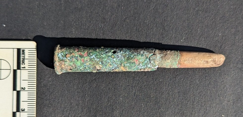
Ok, so, a friend showed me something interesting the other day (hello E.T.!) – a 1920’s dump site in the Glossop area. There are a few of these dumps around, including some early Victorian ones (and no, I honestly don’t know the location of any of these – this sort of thing is a closely guarded secret that even I’m not privy to… sadly!). This one was very small, and had mostly been built over by 1930’s/1940’s housing, sadly. I didn’t find much at all apart from a few bits of pottery (to be talked about in a later post), and some odds and ends including a bead, and some interesting looking buttons. However, Mrs CG found what we initially thought was a rifle cartridge. Well, it turns out it was a cartridge… of sorts, but is actually more of an interesting story than just that.
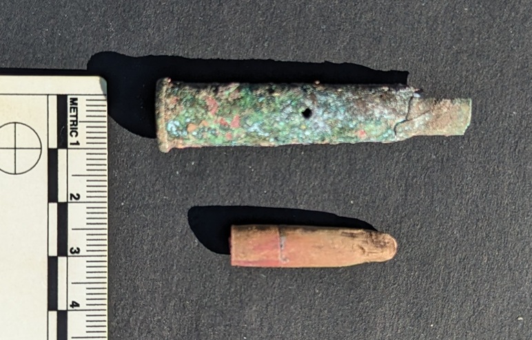
Now, you might remember a few years ago I blogged about the rifle range at Mossy Lea. It’s essentially the story of the local Rifle Volunteer Corps, and in particular their use of different weapons, and their corresponding bullets, at the range. One of these was the Lee-Metford .303 – the standard issue rifle leading up to WWI, and thing that fired one of these:
The two in the middle are from the .303 Lee-Metford, the ones we’re talking about.
Well, I could tell that the found was a .303 cartridge by its shape – it has a lip around the base, and from the other – bullet – end I could tell that it was an early version (the later bullets are more tapered, whereas this looked more rounded); “what ho Lee-Metford!” I muttered to myself. So it was interest that I started to clean the cartridge, thinking that if it’s live I’ll have to hand it into the police station; live ammunition can be dangerous, but it is also very illegal to own without a licence, and I’m not going to argue with that.
Awful photo. Just shocking. I’m in the process of buying a cheap second-hand camera with some form of macro setting.
As I moved round the bullet end, I was expecting a copper jacket covering a lead/nickel centre, the kind illustrated above, only complete. Instead, what I found was a wooden copy of a bullet – exactly the same shape, but made instead of wood, possibly Lignum Vitae or similar non-rotting type.
Honestly, my new phone is truly terrible. I know… a bad workman, and all that, but honestly, I find it very difficult to take a good photograph with it, especially as it has no macro setting, which means I can’t take quality close-up photographs
Ok, I thought, and looking closely at the end of the cartridge, I saw it had no primer cap – the bit that is hit by the firing pin which then explodes and sets off the main explosive charge in the cartridge proper. And looking again, I saw the body of the cartridge had 4 holes drilled in it . I quickly realised that it wasn’t live, and it was in fact a ‘dummy’ cartridge – an inert round, with neither actual explosive (hence the holes) nor fireable bullet – which was designed to be loaded into a rifle safely, allowing training in loading and shooting, without the danger of it being accidentally fired. And this tells a more interesting, story, I think.
You can see where the wooden bullet was turned on a lathe – the nipple at the end is where it was attached to the lathe itself.
There was the hint of a marking on the headstamp – the bit at the bottom where the cap is, and which contains all the details needed to identify the what, where, and when of the cartridge – but the only way to reveal it would be to sandpaper the corrosion away, revealing the metal itself. After some debating, I decided that the metal is too far corroded to do this – there is very little actual metal left, and it is largely just Verdigris, and that to try and ‘clean’ it would essentially destroy the artefact. And then, after debating some more, I thought “tally ho, let’s give it a go”. An interesting, if tense, 10 minute dalliance with some oil and very high grade sandpaper, and voila! The headstamp is revealed:
Amazingly, some detail still remains.
G. 13. VII
Well… down a rabbit hole I went, head first, and with a glass of ‘potion‘ glasped firmly in hand (the bottle said ‘Drink Me‘… who am I to argue with that?), I began researching headstamp markings of early British .303 cartridges. Blimey! I thought pottery was a niche and very geeky subject! I love coming to a focused and highly specialised collecting hobby as an outsider, just dipping in; the level of knowledge – and sheer insanity – on display in some of the collecting forums (fora, technically… I know) is truly outstanding. And whilst I don’t understand the finer points, nor understand why anyone would want to, I fully and completely understand the compulsion, the drive, the need to explore the subject, and to hyperfocus in order to give order to a noisy and disordered mind world. I am also only too aware of what this says about me: I know it… you know it… so let’s move on!
So then, what does it all mean? Well, the ‘G‘ references Greenwood and Batley Ltd of Leeds, the engineering firm who physically made the cartridge. The ‘13‘ is the year it was made – 1913. And ‘VII‘ is the Mark Number – think Version VII of the bullet’s development. Specifically, Mark VII was introduced in 1910 as a development on the earlier types. It contained cordite as an explosive charge (rather than nitrocellulose) and was fitted for the new ‘spitzer’ long pointed bullets (on the right in the photograph of the bullets above), rather than the older style rounded-end bullets – the kind I found on the rifle range. I presume that this was overlooked for the training cartridge, as the wooden bullet is round shaped, not a the ‘spitzer’ type, despite it being a Mark VII on the headstamp. Here is a very detailed article on these developments, should you have an interest in such matters.
So then… why does this matter, beyond a passing interest? Well, the only reason for there to be a training cartridge in Glossop, is if there was training! And the only military training going on here, was with the 6th Battalion of the Cheshire Regiment, the part-time territorial army that I blogged about in the original rifle range article. This training cartridge could only have been used by the Glossop Territorials, and somehow ended up on a 1920’s dumpsite. Genuinely, I love this – something used by one of the men in this photo.
The territorials outside the drill hall in Glossop Town Hall.
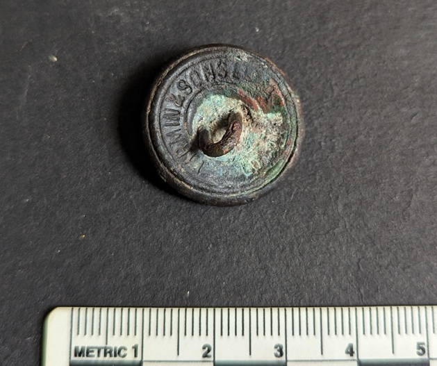
Now, those buttons… I haven’t cleaned them yet, but I could see that one was different, and that I did clean. It came from the same ‘area’ as the bullet (on the surface, 1 metre away), and thus I believe to be from the same dumping episode.
Button cleaned, and with a little oil applied to bring out the detail. I love it.
It’s a simple General Service Button of a post-Queen Victorian type (the crown is of the male type), and was worn by those in military service as part of their uniform. Given that the dumpsite is roughly pre-1920, the button must date from the reigns of either Edward VI (1901-1910) or George V (1910-1936), and was made by the famous Firmin & Sons factory, who still make huge numbers of uniform buttons.
It strikes me that, given the close proximity of the button of post-Victoria (1901), with the training bullet of post-1910, one may assume they are related, and thus the button comes from the uniform of a member of the 6th Battalion, Cheshire Regiment.
One can imagine that following the death – pre-WWI – of a member of the regiment (someone senior enough to have ownership of a dummy cartridge – surely not every soldier had one of their own?), these military bits and pieces were thrown away by the family. In all honestly, I’d like to think it was our old friend, the archaeologist and historian, Robert Hamnett, who, as Colour Sergeant, was very active in the regiment, and who died in 1914… but obviously that can never be proven, however much one hopes! I should go back to see if anything else remains, although I’m almost certain we got everything that was worth finding.
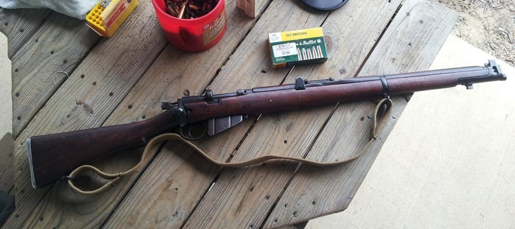
As an interesting aside, I actually own, and have shot, a Short Magazine Lee Enfield rifle – the kind that would have shot the bullet discussed. Built in 1917, it saw active service during WWI, and is a much cherished gift that currently lives in Brandon, Mississippi, USA.
My rifle, the No.1 Mk.III Short Magazine Lee Enfield. According to the stamps on the metal, it was made by the Birmingham Small Arms Company in 1917, it saw action on the Western Front, then moved to India where it was used for training, until it was sold as surplus, and moved to America, where it was bought at a gun show in Jackson, Mississippi, and given to me as a gift.
Alas, it would be difficult to import it from America over here as, quite rightly, there are all manner of complicated and expensive legal hoops through which I would have to jump. Maybe one day, but for now, here I am on a rifle range in Mississippi, firing it.
I need to work on my stance!
Right, that’s it for now. A short and sweet bit of historical archaeology to lighten your day.
I’ll be back soon for more shenanigans, probably involving pottery! What do you mean, “spare us“? Honestly, some people!
Until then, look after yourselves and each other. And I remain.
What ho, delightful historical types (hysterical types?)! Welcome to a new article… don’t worry too much, it’s not pottery (I’m saving that for next time). Nope. This one looks at an interesting feature of Glossop’s personality. Buckle up!
So, some posts I can polish off in an evening (glass of stuff that cheers in hand, obviously). Others takes weeks to brew, and the process can be painfully slow. This one, though, is very different. I started writing it in August 2017… and it’s taken just under 8 years to publish it! No reason as such, it’s just I paused writing it, and moved onto something else, then I went back to it, and then did the same, and so on, and never quite finishing it. In fact, it’s so old, that it was written using an older version of WordPress (the platform I use for my website) which wasn’t really useable any more, and I had to paste the entire thing onto the newer version. Well, here we go.
It’s often said that Glossop is a town of different areas, and with different character. When I first moved here, I realised that a lot of these areas were named ‘town’ – Howard Town, for example. On a simple level, ‘town‘ here refers to a collection of houses in an area rather than the traditional meaning of a large urban conurbation. I wonder of this is a local dialect, or perhaps more likely, Howard Town was named as such, and then the others followed suit, possibly ironically (Roughtown), or perhaps as a way of keeping in fashion (Milltown? Anway, this and is a which got me thinking… how many of these towns are there? And where are they all?
Well, in answer to these questions, may I present…
MILLTOWN
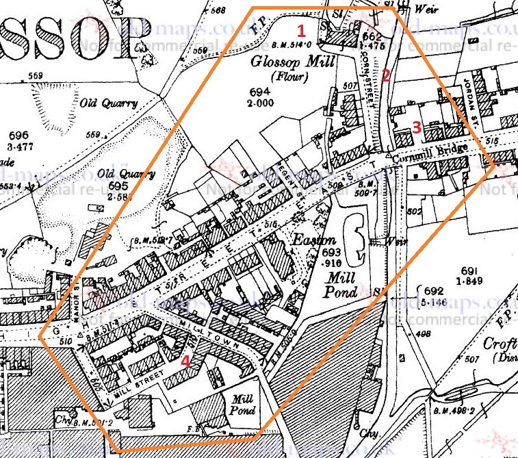
Despite its location, and seemingly obvious derivation, Milltown as an area has nothing to do with the Victorian mills, but instead it is so named because of its proximity to the medieval corn mill. Situated on what is now Corn Street, the mill was owned by the Lord of the Manor, and the people of the area paid to have their corn ground there – and nowhere else. It was, to all intents and purposes, a bit of a racket, but one that was universal throughout the land at the time. As you can see from the map below (and from photographs), there was a flour mill here in 1898, an 18th century building replacing an earlier one. It was demolished in the 1920’s, but you can still see the mill leat running alongside Corn Street. Also, the bridge over Shelf Brook as called Cornmill Bridge, which I did not know until just before I wrote these words… I love that!
Milltown marked in orange, to include the Corn Mill. In reality, Milltown is now just the area to the south of High Street East. On the map above, you can see the Corn Mill (1), Corn Street (2), and Cornmill Bridge (3). Milltown as a present day place is that to the south of High Street East, and comprising Milltown (the street) and Mill Street (4). The area has changed massively, but one constant is the Prince of Wales pub on the corner of those streets (I blogged about it here); pubs are often the only thing left after whole streets are demolished, as indeed is the case here.
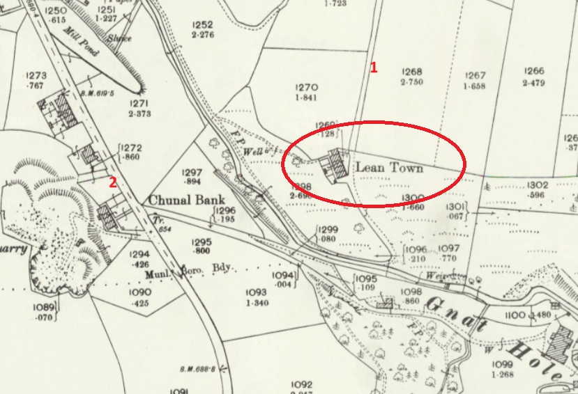
LEAN TOWN
Lean Town is the name given to a group of four houses at the bottom of an apparently unnamed lane that runs from Hague Road to Gnat Hole. I can’t believe it is unnamed, but there you go… no map or document has so far given me a name! As you come from The Beehive toward Derbyshire Level, you pass a right hand downward track – follow this and eventually you hit Lean town. I wrote about Lean Town, here.
Lean Town. 1 is the track down from Derbyshire Level, 2 is Chunal.
The origin of the name ‘Lean Town’ is unclear; it might mean lean, as in not very rich, or poor for growing crops, or might be derived from ‘ling’, meaning the plant ‘heather‘ that grows around here.
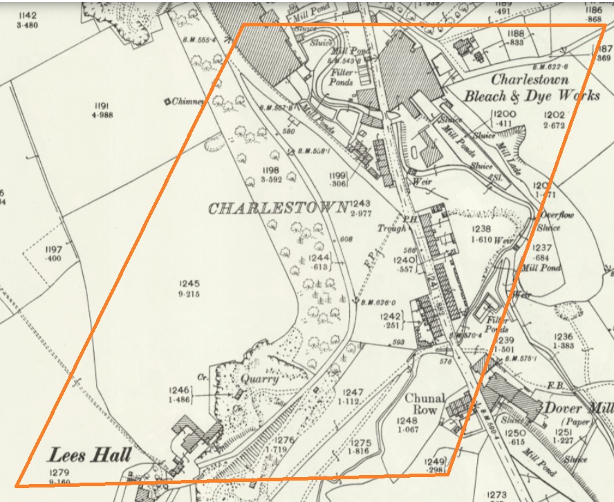
CHARLESTOWN
Once an area in its own right, it is now largely remembered in the name of Charlestown Road (and Charlestown Motors who I can heartily recommend, as it happens). It was named after Charles Hadfield who lived in Lees Hall in the late 18th century, and built the mill in Charlestown (now flats and houses).
Sort of this area, give or take. Charlestown Road runs from top down, and the PH (Public House) marked on the map is now Steak Land (replacing a firm favourite of mine, Casa d’Italia, although the word on the street is the Steak Land is amazing, so there’s that!)
ROUGHTOWN
Hope Street in Old Glossop was known as Roughtown, seemingly referring to the uncouth behaviour of its inhabitants, largely quarrymen from the nearby Glossop Low Quarries just up the road.
1 – Hope Street, 2 – The Greyhound pub, a factor in Roughtown’s reputation.
Apparently Roughtown was used as a semi-official name, with it appearing on census returns and trade directories of the time. Sticking with Old Glossop, we have…
TOP O’ TH’ TOWN
The area between Thorp Street and Church Street in Old Glossop. It is, I suppose, quite literally the top of the town.
And the area at the end of Top o’ th’ Town is known as ‘Town End‘, which make sense. Over in Whitfield, however, we have…
FREETOWN
Stretches from the bottom of Whitfield Cross to the junction with Charlestown Road.
This sort of area, here. and particularly the road called Freetown.
Technically, and originally, Freetown was the name given to this area of Whitfield, with the name being derived from the fact that the land in this area, and subsequent houses built here, were freehold, as indeed it is still the case (my own house here included).
HOWARD TOWN
Essentially, what we understand as Glossop – the railway, Norfolk Square, the crossroads, and the whole area around the market and Wetherspoons.
Named after Bernard Edward Howard, 12th Duke of Norfolk (1765-1842) who invested heavily in Glossop – money and time. He built roads, the town hall, remodelled the whole area, and changed the focus of Glossop from what we now know as Old Glossop to what we now know as Glossop, but was originally Howard Town. This may have been the start of the ‘town’ naming process, as others followed suit, whether by flattery or through satire.
JERRYTOWN
A bit of an obscure one this – it’s mentioned by Hamnett as stretching along High Street West, from roughly The Grapes inn to the former Junction Inn and around.
1 – The Grapes, 2 – The former Junction Inn (now Simple Lettings), 3 – Primrose Lane.
Apparently named after a Jerry Sykes (1779 – 1856) who built a number of houses in this area in the 1820’s.
And there we have it! The many towns of Glossop town. I can already feel several of you desperate to tell me that I’ve got something wrong, or that I’ve missed a ‘town’ out. Please feel free to do so. Honestly, please let me know if I’ve messed up – I’d rather the information was correct.
I do have pottery for next time, and I owe you a new Rough Guide To Pottery – Part 11 unless I’m mistaken, you lucky people, you.
In other news, I’m doing a guided walk at the end of the month… which should be amazing.
Now that spring is coming I’m going to be walking the route of the Where/Whens so far published, and trying out some other new routes. Tickets for these will be available after the above walk has been done, and will be at the weekend, so everyone can take part – come and join us! Watch this space.
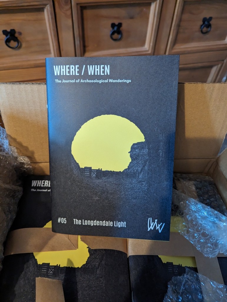
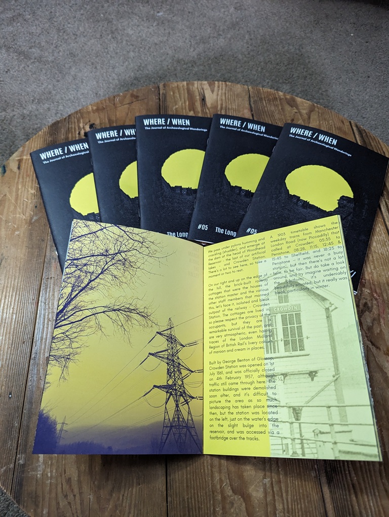
Talking of Where/When, No.5 has just been released.
An exploration of the history and archaeology of the Longdendale Trail, from the start at Hadfield to the tunnel entrances. Honestly, there is so much to see.
It’s available to buy from the usual places – Dark Peak Books, 96 High Street West, Glossop; the website’s store; or you can track me down and buy one.
I’m busy! Too busy, but it’s happening! I’ll post again soon, but until then, please look after yourselves, and each other, and I remain.
What ho, you wonderful people, you! Well, here we all are. Make yourselves at home. Canape? Glass of something cheering? I can heartily recommend the red… cheeky, but hexagonal in the correct places, if you know what I mean. Right, take a seat and I’ll begin.
Today’s offering concerns a subject very dear to my heart. No, not pottery… I’m not completely one dimensional, you know. Nope, this article concerns pubs. And alcohol. And in particular the effects derived from the consumption of the latter. “What’s this?” I hear you cry… “a post about drunkenness? By a man with the sober reputation of good old TCG?” Hmmm… let’s move on.
So, I was reading through the diary of George Booth (discussed further here) the other day, and came across this absolute gem:
Thursday July 25th (1833) Last sunday afternoon [21st July] I went with Harriet Hough, our Mary, James & George Booth to Glossop Church. After service we went to Joshua Shepley’s at the Royal Oak and then returned by way of Bridge End Juncksion, Simondly and we did not forget to call at each place and to my own shame I was quite drunk. fell and broke Miss Hough`s Umbrella and tore my Trowsers.
I say!
So, what are we to make of that startling confession? We could judge Mr Booth harshly, but let’s face it, we’ve all been there (though I don’t recall ever having broken someone’s umbrella). Two things leap out of this entry. Firstly, there are the post-church snifters – seemingly many of them – in what was, for all intents and purposes, a pub crawl of Glossop that starts in the Royal Oak and ends at Bridge End (appropriately enough, where Wetherspoons is now). The amusement here is, I think, the result of a sincere and honest Georgian/Victorian gentleman, getting sozzled after church, staggering home, breaking an umbrella, and ripping his trousers. Quite how this happened I’d love to know (the ripping, not the drunkenness… I’m very aware of how that happens!), but the diary entry is somewhat lacking in details.
Secondly, there is the comment that they returned via “Bridge End Juncksion [junction]”, implying the meeting of a number of roads. My sherdy-sense tingled, and the question was asked: “is there a blog post here?” Well… here we are!
Ok then, let’s examine the route our man and his party took, firstly from the church to the Royal Oak. There are two ways he could have walked. Firstly, down Manor Park Road (then called Hall Street) and left down what was then Cowbrook Lane, but is now the A57/Sheffield Road, and along to the Royal Oak. This would have had a decent road surface on it now – the turnpike road – the Snake Pass – had been open for some 12 years at this point. But this would mean they would have to double back on themselves to get home. No, I think it would make sense to take the more direct, and almost certainly original, route, along the track from Hall Fold (passing the Glacial Erratic) and via Pyegrove, finally popping out at the pub on the road there. This was an established track, rather than the simple footpath it is now, and for many hundreds of years was used by man and beast to get from (Old) Glossop to Hurst, Jumble, and ultimately Whitfield – a not insignificant trackway to be honest. There was also a spur from this track to Mossy Lea farm, and joining Doctor’s Gate.
All Saint’s Church, Glossop circled in green at the top. The Royal Oak is circled in blue at the bottom. Hall Street (now Manor Park Road) is in orange, The Pyegrove track is in red, and continues beyond the Royal Oak to Hurst, etc. In pink, we see the spur – Woodcock Road – that goes to Mossy Lea and Doctor’s Gate.
The Royal Oak was constructed in or just before 1818 as a purpose built alehouse by the Joshua Shepley mentioned in the diary. It sits on the then new Snake Pass, and had stables and a blacksmith, as well as water trough. Shepley clearly knew he had a captive market – the first watering hole you come to after the Snake Pass, and the last as you leave Glossop for the road, meaning a last chance to water or shoe a horse, as well as a pint, too. As a building, it’s a wonderful example of the neo-classical late Georgia/Early Victorian ‘symmetrical with a central doorway’ style that was very common amongst purpose built pubs of the time. Actually, it’s a little off perfect symmetry, as indeed they all are, presumably to accommodate a larger room and a smaller one – here the larger is on the right – but let’s call them symmetrical. The porch covering the front door is a later addition.
I love this view – it really shows the looming presence of Shire Hill in the background. And honestly, Shire Hill looms… I actually find it quite an intimidating place. Another view, the track from (Old) Glossop via Pyegrove comes out on the left The trough at the front… full! The last time I saw this, it was bone dry. I always find it odd, and perhaps a little mystifying how the water table fills up, and how quickly following a decent amount of rain.
I feel that if Booth purposefully went there to see the place, and the man, he would certainly had more than a single drink; at least two is my guess, although potentially more. We’ll say two to be on the safe side.
DRINKS CONSUMED: 2
So then, from here they would have wandered down Cowbrook Lane, and come across what would become the Commercial Inn on the corner there. But whilst the building – or an earlier incarnation – was standing there (a lease for the building was granted in 1828), it didn’t have an alehouse license at this point (that only came about in 1839). However, it might have had a simpler beerhouse license, as almost anyone could obtain a license to sell beer brewed on the premises if they paid a 2 guinea fee. One can imagine the sort of clientele this sort of establishment could attract – cheap and cheerful beer a plenty. I’m not 100% convinced our man Booth would have frequented a beer house, but I could be wrong – especially if he’s on the razz! So, benefit of the doubt, he bent his elbow at the Commercial, or what was there at the time.
The Sheffield Road side of The Commercial Inn, blocked up doorway visible front and centre. This is the door that George Booth and party would have entered on that fateful evening. Close-up of the doorway. A dark and rainy view of the Manor Park Road side of the pub, now the only way to get into the building. Again, the symmetry is obvious.I’m not certain, but these two houses share all the same features – windows and doors, and symmetrical shape – as the pub they are joined to… they have to have been built at the same time, or at least soon after (actually, the stone size and shape is slightly different – look left where the join in the roof is. I wish I’d taken a closer photo now. But I’d still bet money that they were built by the same person, and within a year or two.
The current building is also of the ‘symmetrical’ style, although this example has the central doorway on both the turnpike road and on Manor Park Road (then Hall Street), which make good commercial sense, although the Sheffield Road doorway has been bricked up. I’ve said it before: objects (in this case a building) acquire a biography, and throughout their ‘lives’, like ours, they constantly change, and often carry the scars of their history. A bricked up doorway prompts so many questions, some of which are easily answered, others not so much. Was this an entrance to a separate room? The Smoking Room? Taproom? Lounge? Vault? Or was it an entrance to the private quarters?
DRINKS CONSUMED: 3
Onwards and upwards. From here, the next establishment he might have come across is the Mechanic’s Arms at 99 High Street East. Built in 1831 by Jordan Hampson, who is listed as a beer seller in the 1841 census, and who would have been the landlord in 1833. The building ceased to be a pub in 1933 because of its “structural unsuitability”, and the building was demolished in 1971. Regency Court now stands in its place.
Not a lot to say here! Somewhere in the middle of this photo stood the Mechanic’s Arms.
So we might assume an eyeball straightener here, then.
DRINKS CONSUMED: 4
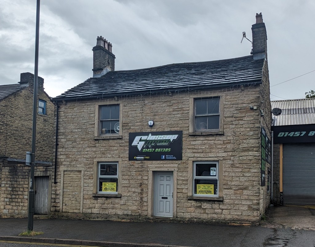
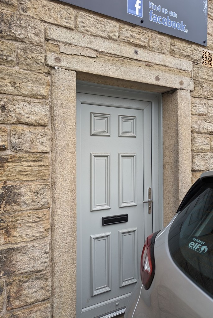
Next up and a little further down we have The Peartree Inn. Built in 1818, it was originally known as the Kings Arms.
Once you notice it, you can clearly see it was once a pub – symmetrical windows with a central door. Although, there is another bricked up door on the left, again perhaps the entrance to a separate room.The bricked up doorway up close. What was originally – I presume – the main entrance to the pub, and through George Booth and his party would have passed.And, o’ happy day, a bench mark! For those of you who don’t know, these were carved onto buildings to mark a specific measure height above sea level in the 1840’s and onwards. I love these things – the horizontal line marks the exact point, and the arrow below shows you where. This is exactly 504ft 7″ above sea level. Man, I love a bench mark! Check out this blog article, and many more like it in the archive.
It was here that in 1830 that the officers of a detachment of the 10th Hussars and 4th Regiment of Foot were stationed, being given the task of putting down a potential riot of spinners who were demonstrating in favour of a standard rate of pay. In 1832 it would have been owned by a John Woolley, himself an old soldier. We might safely assume they took one drink in the Peartree, although the chance of a chat with an old soldier… let’s say 2. It is a Grade ii listed building, with the official listing thus:
House, now offices and attached wall. Early C19 with late C19 and C20 additions. Coursed millstone grit with tooled dressings and stone slate roof. 2 stone end stacks. EXTERIOR: 2 storey and attic. Street front rendered. Almost symmetrical 2 window range. Off-centre doorway with C20 door in flush ashlar surround flanked by single plain sashes, above 2 plain sashes, all in flush ashlar surrounds. Left return has blocked tall opening at first floor level and above single plain sash. Right return has ground floor with elongated C20 window opening. Rear has C19 parallel extension with end stack. INTERIOR: not inspected. SUBSIDIARY FEATURES: adjoining wall to left has doorway in flush ashlar surround with plank door.
The Peartree ceased being a pub in 1926, and is now the offices of Glossop Tyres – make sure you check out the building the next time you are getting new tyres.
DRINKS CONSUMED: 6
Swaying slightly (we’ve all been there) they would have set off – it’s thirsty work, all this walking… Next up, the Howard Arms, for at least one.
Howard Arms, Ellison Street in the foreground. Again, like the Peartree, it was originally symmetrical, with the door central between the two ground floor windows. It was bricked up when the pub expanded into the building next door sometime after the 1930’s. That is the one George Booth and party would have used. A view of the Howard Arms in 1904, central door still in situ. The person in the doorway is likely to be the wife of John Green Hudson, landlord at that time. Image from the always excellent Glossop Victorian Architectural History site – HERE. Well worth a browse as it is full of old images, and catalogues our extensive and important Victorian heritage…. it really is an important website.As it is now, and after the windows were widened – still 3 light, only wider.
Named after the Howard family, the Dukes of Norfolk, it was built in 1800. It is superbly situated for passing trade, being at the crossroads of the old Woodhead Road (now Ellison Street) and the turnpike road running east-west, later expanded into the Snake Pass. Indeed, the trustees of this road building committee held their first planning meeting here, on 4 June 1818, and celebrated its opening four years later with a slap-up meal in the pub. A very nice establishment (possibly), I feel certain that more than one was consumed here. For one, he was already 6 drinks into this adventure, and at this point, the genie is hard to push back into the bottle, and trouser-ripping and umbrella-breaking are all but inevitable. But I also get the impression that he is having a good time, despite the shame he felt the next day, and the diary makes it very clear “we did not forget to call at each place“.
DRINKS CONSUMED: 8
From here, the party would have headed further down, and into the Norfolk Arms. Built in 1823, there is quite a bit that can be said about the pub, but I feel here is not the place – this is Mr Booth’s time to shine – so I’ll keep it brief. Built in 1823 as part of the monumental shakeup of this area, and the creation of Howard Town, The Norfolk Arms has been much altered and expanded over the years, especially in the late 19th century, but at its core it is another example of that neo-classical ‘symmetrical with a central door’ that define so many purpose built pubs of the late Georgian/Early Victorian period (the front porch is a later addition).
Apologies – this shot is taken from Google Maps’ Streetview. I took several photos of the building, from several different angles… but for some reason, none of them came out ok. Odd, but there you go. I’ll update the photos later, but for now I just want to get the article out there! You can see the central, ‘symmetrical’ building, with the later wings added. Oddly, this is the only photograph that worked properly! The bench mark on the south-eastern corner of the building marking 497ft, 1″ above sea level.
It is also slightly grander than many of the other examples – larger and more formal, it was also used as the town’s post office in the 19th century, as well as the coaching inn, where stage coaches between Sheffield and Manchester would stop. The Norfolk Arms is a Grade ii listed building, with the official listing reading thus:
Coaching Inn, now public house. 1823, altered late C19 and C20. Coursed millstone grit with ashlar dressings and hipped Welsh slate roofs. 4 ridge stacks and 3 wall stone stacks plus 2 louvred vents to left. PLAN: double-depth. EXTERIOR: 2 storey. High Street front has 7 windows arranged 2:3:2. Slightly projecting 3 window centre has central stone, flat roofed single storey porch with blocking course, plain square columns and C20 margin light glazing. Flanked by single plain horned sashes, above 3 similar windows. Wings have 2 similar sashes to each floor. All windows have painted ashlar lintels and sills. Left return has doorway in flush ashlar surround with overlight and to left single small then 2 large casement windows, above 3 plain horned sashes. Right return to Norfolk Street has central doorway under single storey flat roof porch with dentilled cornice supported on square Tuscan Doric columns, moulded round arches with moulded imposts and stressed keystones. To left single plain horned sash and to right large former shop window with former doorway to left and 3 round headed lights to right within plain pilaster surround with moulded fascia board. Above 3 plain horned sashes and small inserted casement window.
And it’s difficult to argue with that! The landlord in 1833 was a Joseph Oates, and I think they had single drink in here, as they decide to call it a night and head home.
DRINKS CONSUMED: 9
The diary states that they went via “Bridge End“, which means they would have crossed what was then a new bridge, but not yet Victoria Bridge. This whole area was in flux at that time, with new road layouts and buildings going up, and it may well have resembled a building site. However, there was one shining beacon on this dark and lonely road out of Glossop, one place of refuge and light. And beer; The Albion Hotel (also known as The Trap, The Last Orders, and now The Brook Tavern), which in 1833 was brand new, being built the previous year. Maybe just one more…
The Brook Tavern as it is now, originally The Albion. The porch is a later addition, but would have originally been like our other pubs so far, symmetrical with a central door.
Set back from the modern road now because it sat on the original line of the road and bridge (and lines up with Smithy Fold and Ellison Street), it would have been a magnet for the party – to celebrate crossing the bridge, and one for the road. The last. No more… “Ah, go on then, let’s have another…” The landlord at the time would have been a Charles Calvert, who by this point would probably have been glad to see them go!
The original line of the road can be seen by looking along the shop fronts here – they pinpoint the site of the original bridge, and Ellison Street beyond. The new road curves more to the west, over Victoria Bridge.
TOTALDRINKS CONSUMED: 11
And so, singing hymns – and other, less saintly songs – our party staggers into the night, and into infamy. Blimey… 11 drinks! Not bad for a Sunday session, and certainly more than I could do anymore. The ‘pub crawl’ is a brilliant piece of social history, a glimpse into the personal life of a person whose public life was probably very different, possibly very austere and proper – so the idea of him getting squiffy on a Sunday is amazing if, as he notes, shameful, as the sobering up starts, and he fits back into his public persona.
Now, here is also something of a question mark. His diary records that they went via “Bridge End Juncksion, Simondly“, but that is an odd way of putting it. Bridge End is Victoria Bridge, but it is not in Simmondley. Whitfield or Glossop, depending on which side you are standing (I get the feeling Bridge End proper is on the Glossop side of the brook), certainly, but not Simmondley – that’s over the water of Long Clough Brook. There is Bridge Field, which is just in Simmondley, but it is much further away. No, I suspect he may simply be confused: a bridge over water from Glossop… that’s Simmondley. Plus, he’s a Chisworth/Charlesworth man out of his territory, he may not have understood the finer points of local geography. And let’s not forget he was also somewhat impaired, mentally, by the time he arrived there!
So then, the ‘Juncksion’? A junction, or a meeting of roads. But from where? This is where Glossop’s history gets murky… and interesting. It is a dispersed settlement, with farmsteads all over, all of which feed into the centre – Old Glossop. Because of this, trackways spread spiderweb-like all over, connecting all of these places and people. A crossing point like Victoria Bridge – or rather the bridges that were there before – were naturally targets, focal points attracting all the tracks, as ways to cross Glossop Brook, would not have been common. Here on the map is shown the tracks. It should be stated that not all would have been in use simultaneously, they would have been introduced as needed; a new farmhouse built, perhaps means new tracks are made – but all heading for the single focus of the crossing point, the bridge.
The tracks that meet at Victoria Bridge. Pink: Victoria Bridge, Red: from Ashes, Green: from Simmondley (the main Simmondley to Glossop track, and which becomes Bank Street [The Bonk], Blue: from Whitfield, Yellow: the track to (Old) Glossop, Dark Green: the track to The Heath, and on to Padfield, but also Woodhead, and ultimately Yorkshire. A Juncksion indeed.
This article owes a huge debt to the book History in a Pint pot by David Field – a brilliantly detailed look at all of Glossop’s pubs, past and present, now sadly out of print and ridiculously difficult to get hold of. The library has a copy, so go there and read it. I’d also like to thank George Booth, especially as this is the second article inspired by his diary. I also feel slightly bad about lampooning him, however good natured it might be; after all, the shame he felt at being drunk was real enough to write about it in his personal diary. By way of an apology, I might raise a glass of the stuff that cheers his way tonight… although I’m not sure he’d approve.
However, I’m genuinely half tempted to recreate this monumental pub crawl – starting at the Royal Oak, and finishing in the Brook Tavern… and celebrate the end by tearing a pair of trousers and breaking an umbrella? Who’s with me? 21st of July this year is, coincidentally, a Sunday, but I feel that we live in less civilised times, and those of us who work will not appreciate waking up Monday morning. We could do it the day before – Saturday 20th. Just a thought… let me know what you think.
In other news, Where / When issue 2 is selling like hot cakes, which is great as it means that I can publish Where / When 3 relatively quickly. I also have some archaeological/historical walks planned for the summer – essentially me doing a Where / When live, with a bunch of you, if you fancy. And perhaps incorporating the inaugural George Booth Historical Stagger? But honestly, watch this space as lots is being planned…
Until the next time then, good people of Glossop – and beyond – please look after yourselves and each other.
Well, I have an interesting offering for you this time, and one that doesn’t involve pottery, sadly. I know, I know! I can hear your yells of pain and misery from here… and my how they sound like whoops of joy and celebration. Joy and pain are two sides of the same coin I suppose – the Yin to the whatsit, and all that. Although, I have to say the chap who appears to be doing a buck and wing clog dance whilst singing ‘Happy Days Are Here Again‘ does seem to be hiding his sadness a little too well… Hmmmm.
Anyway, I digress…
So, I have a friend who bakes cakes, she’s something of a connoisseur as it happens, and people are always giving her cakes as presents. Practically throwing them at her. I have another friend who takes his music very seriously, and people are always giving him records and cds with the words “I thought you might like this“. I have yet another friend who likes his beer, and scarcely a week goes by without someone bunging cans and bottles his way, saying things like “I was in Harvey Leonards the other day and I saw this and thought of you” – almost drenched in the stuff he is… and permanently inebriated.
So, I like old things… and especially pottery.
Now, I was once at a dinner party, glass of the old stuff that cheers in hand, swaying slightly, and conversing with a chum, when another chum bounded over and said “What ho, TCG! Oooooh, I say old bean, I have a gift for you” and off he scurried. He returned moments later clutching a plastic bag which he handed over to me. What could it be? It was like Christmas! Excitedly, I opened the bag…
What it was was a half a muddy brick. A perfectly normal 19th century house brick, broken in half, and still damp. They thought it might be old and presumed I’d want it.
Well, I mean to say, of course one doesn’t look a gift thing in the old whatsit, but… well… You know. And this sort of thing happens surprisingly – worryingly – often. So you can appreciate then why the words “I’ve got something for you” can sometimes sound a note of concern.
Don’t get me wrong, I very much appreciate the thought, it’s kind and most welcome. Honestly, little packages clinking with pottery fill me with a warm fuzzy feeling, and truthfully I’m never happier than when I’m rifling through shopping bags of finds, furtively handed to me in the park, looking shiftily around, like some sort of Soviet-era spy game. Indeed, being able to answer people’s questions of ‘what is it?‘, ‘how old is it?’, and the often asked ‘what’s wrong with you?‘ is the reason I write this website… and why all seven of you read it.
But for the record I also like beer and music. And money… a shiny shilling or two wouldn’t go amiss, either. And did I mention the stuff that cheers? I like that a lot!
Other times, however, gifts clasped tightly in hands can be amazing. I have had some genuinely wonderful, alarmingly, breathtakingly beautiful, and truly interesting things given to me to look at: pottery, bricks, flint… spoons!
And so it was the other day that I was skilfully tracked down by the always wonderful S.T. who thrust at me a cardboard box, tattered at the edges, and yet so full of promise (the box that is, not S.T… good old S.T. looked radiant as ever).
What wonders lie within?
And that is the start of this episode. The objects contained within – on loan in a distinctly non-permanent way – were all found in the fill of an old mill pond, the exact whereabout of which are shrouded in mystery (but which I’ll happily disclose for the price of a glass of something nice… I never said I had scruples, nor that I wasn’t cheaply bought).
So come, let’s explore the box together.
Honestly, who can’t be excited by this.
The box itself is interesting – an armorial device with the initials DSC and a motif of crossed razors… a quick Google search tells me the Dollar Shave Club. Now, given that I have water from the holy well at Walsingham Priory safely contained in a medical urine sample pot, it’s not my place to pass comment. The box is, however, different from their normal home, which is apparently an old clock. Mind you, this is the same S.T. who uses an egg as a scale in her photographs… so nothing should surprise us.
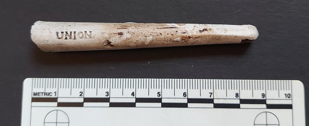
So what was in the box o’ bits? First up, a clay pipe stem.
Interesting stuff, and a good example.
Plain apart from the words “UNION” and “PIPE” stamped on the sides. I browsed my sources for information about this, but came up with nothing, alas. It is probably an example of a political pipe, that is those that carried slogans and allusions to important political ideas and events of the day. No doubt this one was connected with the idea the Northern Irish union with the United Kingdom. The Unionists demanded to remain part of the UK in the face of an increasingly independent Republic of Ireland, which itself was demanding that Ulster be a part of it. It’s an interesting history, and one that obviously resonates still to this day. Given that a lot of clay pipes were aimed at a target market of Irish immigrant workers in Britain, it’s unsurprising that many of them contained words and phrases that reflected politics back home. Indeed, such was the market that many clay pipe manufacturers even gave their address as Dublin on the pipe bowl, despite being made in Birmingham or similar. It also plays on the belief held at the time that somehow Irish clay pipes were superior in quality.
The mouth piece is interesting, and shows the manufacturing process clearly. Formed in a two-part mould, the pipe often has mould lines along it length that can be quite thick and sharp, especially if the mould is old and worn and doesn’t close properly. The answer is to pare away the flashing with a knife, which you can see happened here.
I think I can make out some tooth marks on the mouth piece. The dark staining is the result of it lying next to something metal and rusty.
Date wise, the shape (straight, and quite chunky) would put it sometime in the early 20th century – let’s say 1910? It looks similar to the shape of the McLardy pipe here, and it would also fit with the political message.
Next up… a boot!
A tiny boot!Yep… it’s a boot.
The detail of this thing is amazing; it’s old – probably Victorian in style – and one of those boots with an elasticated side (I actually have a pair, and very dapper I look in them too). It’s made from pewter or similar – lead-based, certainly. I have no idea what it actually is, but it’s possibly some sort of charm – if you look closely at the front you can see the remains of a small ring which would have been used to hang it from something… a pocket watch perhaps. Or, it might have been a pin cushion, with a material filling the hollow allowing pins to be pushed in.
However, whilst looking closely at it, I noticed something.
These photographs are shocking, even by my standards. I have a new phone with a camera that is truly disappointing – it doesn’t even have a macro setting. I’m not necessarily blaming the phone – my photos have always been bad – it’s just that it doesn’t help.
You can just make out a pair of tiny mice, one on each side, crawling up the boot.
The Mouse in detail – you can make out the tail and back leg. Also, you can the attention to detail in the boot – the heel is worn.
A mouse in a boot or shoe was a common theme in the Victorian period apparently, and the Northampton Museums website seems to provide an answer why:
“Shoes can be thrown at weddings to wish the couple a good, long and useful life. The shoe was also a sign of fertility and many years ago a boot was often buried in the home of the newly wed couple. Inside the boot was placed a grain of corn, which it hoped would attract mice to nest and breed. From this came the idea that the wife would bear lots of children, who would look after her and her husband. Many Victorian miniature shoes show a mouse playing in the shoe.“
So there we go – vermin in your footwear can lead to many children. Who knew?
Next we have some toys, and to start with, a wonderful hollow cast tin soldier.
The large bearskin hat suggests he is a guardsman of the Grenadier or Coldstream Guards of the British Army.
Remarkably, he still has his head, which is normally missing from found soldiers. The paint is in good condition, to0 – blue trousers and a red tunic. To make these Victorian to early 20th century figures, a mould is made into which a molten tin alloy is poured. This cools immediately on contact with the exterior, and which allows the still molten interior to be poured out, thus saving on tin. They were hand painted, probably using some very nasty heavy metal based paint – so don’t chew any you happen to find.
Really good condition.
When new, he would have originally looked something like this:
Modern versions, stolen from here
This example is certainly better than the one I found… very jealous!
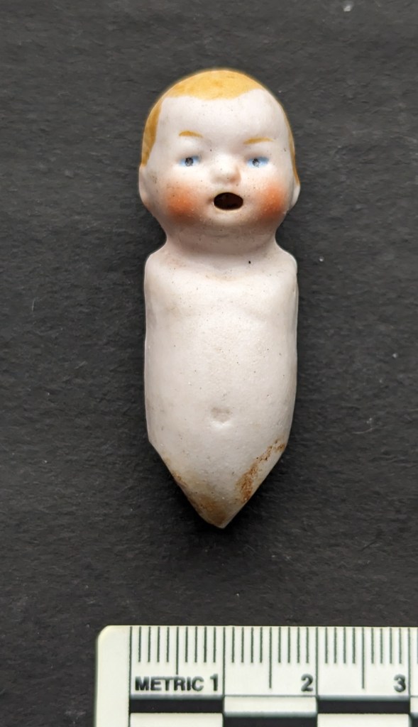
Next up we have… well, let’s not beat around the bush. We have nightmare fuel. The kind of thing that haunts my dreams.
I mean… honestly!
I’m not fond of dolls, they honestly give me the creeps. But I think it is quite common for humans to be unnerved by things that look quite like us, but which aren’t us; the ‘Uncanny Valley‘ is the term for such feelings. It’s not an outright phobia, more a dislike or a sense of unease. Although I have to say, I do like the expression it has – a sort of open-mouthed surprised look… not unlike my own expression when I unwrapped this wonderful, if creepy, item. So then, here we have an remarkably complete Victorian bisque – or unglazed porcelain – doll. It’s tiny, and only the body remains – the arms and legs would have been a material, or perhaps porcelain with a single rivet joining them so that they were movable. The whole would have been clothed, or wrapped in a blanket, but this has long since rotted. The incredible detail in the colouring of the eyes, hair, and face would indicate that it was a relatively expensive one, and it would have looked something like this when ‘alive’.
Stolen, with my usual lack of shame, from this website.
On the back is impressed the word ‘Germany’, which is where the doll was made, Germany being world renowned as the centre of doll manufacturing. There is also the number ’61’ just visible on the left shoulder, which is presumably the mould number.
A ‘raking light’ shows the impressed maker’s mark.
Sadly I can’t find any more information about this doll in particular, but at one point this was a prized toy belonging to a little girl, and at some stage the doll was lost or thrown away. A melancholy thought.
Next up is… yep, more nightmares made solid! Thanks for this, ST.
Less or more creepy?
Another bisque doll, and whilst it is complete, it’s just the head and shoulders, which would have been sown into a cloth body. It would have been sold very cheaply as there is no painted features, but would nonetheless have been a much loved toy. You can see how it was made – cast in a mould, and hollow:
You can see the marks of the liquid porcelain as it was poured into the mould.
Creepy, but a wonderful
Whenever I find toys or marbles, I always feel slightly sad that they were lost or discarded. I don’t like the idea that somehow the things that matter to us as children shouldn’t matter to us as adults, and that there should be a clear and clean break with our childhood. Luckily though, I’m the adult now, and I get to decide what being ‘an adult‘ means… hence I have display cabinets filled with Star Wars and Action Force toys – and Airfix toy soldiers – from the 1980’s in our spare room. My childish things are very much still with me… but I digress. Again
After those last two I need a snifter of something that cheers.
Well, we started with a pipe, so let’s end with a pipe. Truly, I would love to smoke one. There is something wonderful about a pipe, something calming; the chap who takes charge in a crisis smokes a pipe. As does the dashing hero, or the bookish academic, or the romantic lead. Sadly, it’s that damned cancer that puts me off (that, and Mrs CG threatening divorce).
So here we have here a fairly standard, but always welcome, Late Victorian clay pipe.
In very good condition, and missing only the mouthpiece.
I actually have a whole article on clay pipes almost written, so I won’t go into too much detail here, but it’s the shape and size that tells us the date (briefly, if it has a bulbous bowl and slanted rim, it’s Georgian or earlier. But if it has an upright bowl and horizontal rim, then it’s Victorian. Also, a smaller bowl is earlier, whilst a larger bowl indicates it is later.
There is some lovely, if very common decoration on this pipe:
I love this.
The rouletting around the rim is very typical of the type, as is the stitching on the front and back, which hides the flashing caused by the joining of the two sides of the mould. There is no maker’s mark, not even a ‘Made in Dublin’, or similar Irish theme, alas. And as I say, certainly not uncommon, but always great to find one in good condition.
And with that final pipe extinguished, the journey is over: the ‘box o’ bits’ has been explored, and we may all go back to whatever it was we were doing before I interrupted. My sincere thanks to ST for allowing me to share this with all seven of you, and for following and supporting me for so long here at the Cabinet of Curiosities.
In other news, I’m currently putting together the next edition of Where/When – this one covers a walk from the Bull’s Head in Old Glossop to The Beehive in Whitfield along ancient trackways, and taking in some interesting archaeology. As usual, you will be able to buy a physical copy, as well as download a digital version. I’m also going to do it as a guided walk, so you’ll get a chance to Wander the route with me – which may or may not be a bonus, depending on how much you like pottery! Watch this space.
Talking of which, more pottery next time. But until then, look after yourselves and each other.
(Will I make it before January 31st?.. that is the question)
What ho, wonderful people, what ho!
And my how I have missed you all. Well, most of you at least. Not you Mr Shouty-Outy, nope. But surprisingly today’s offering is pottery free, so you have no need to say anything at all.
So then, Christmas is over, and the New Year’s hoohah is done with… alas. Invariably at this time of year, a certain sombreness overtakes old TCG. Gone is the ‘devil may care’ attitude of yore, and instead a certain ‘not even the devil cares’ feeling overtakes one’s bean. There is a noticeable drooping of one’s shoulders, a subtle sadness of the ‘O the pain of life‘ variety, and a distinct lack in the old J de V. A funk, if you will, the like of which even the stuff that cheers – if taken in the correct dose – fails to cheer. Not that it stops one from trying, obviously.
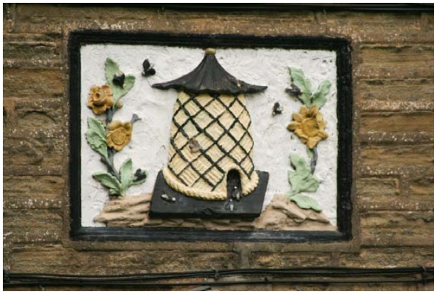
And so, trying to raise my spirits, I found myself idly flicking through the wonderful History In a Pint Pot by David Field, which is a detailed history of all of Glossop’s pubs, past and present. Highly recommended, but sadly long out of print, athough the library has a copy if you want a read… and you should. I was looking at my local, The Beehive, when at the back of that particular entry was an old advert dated to sometime in the Victorian period that looked vaguely familiar.
Beers, wines, spirits, cigars, horses, stone… there’s not a lot that can’t be bought at the Beehive.
*Ping* went a synapse… a second passed… then *thunk* went a receptor (I may have slightly overdone the festivities this year, and the old noodle is functioning at approximately half normal speed). Where had I seen it before? And why was the advert significant? What? Where? When? And then it hit me… St Mary’s Road. Oh yes… something I should have blogged about before now.
Sooooo… a few years ago someone messaged me via, I think, Twitter, and asked if I had seen the name carved into the the gutter of some houses at the top of St Mary’s Road, and did I have any information.
Before we go any further, confession time. I am, as you might have realised, quite good at some things (*cough* pottery *cough*) and terrible at others (*cough* communication *cough*). I am also fairly disorganised in some areas (*cou… YES, alright, we get the picture… here, have a throat sweet). So it should come as no surprise to anyone that I cannot for the life of me recall who it was, nor can I seem to track down any record of the conversation. So if it was you, then please accept my humble apologies, and step forward to make yourself known and famous to all 7 of the people who read these posts (including Juan in Venezuela).
So then, had I seen them? No. And had I any information? Also no. And so it was I found myself walking down St Mary’s Road, muttering to myself as I am wont to do.
No’s 116 to 122 make a small terrace of four stone-built houses, typically mid-late Victorian in shape, and are much like all the others around them.
The corner of Duke Street and St Mary’s Road.
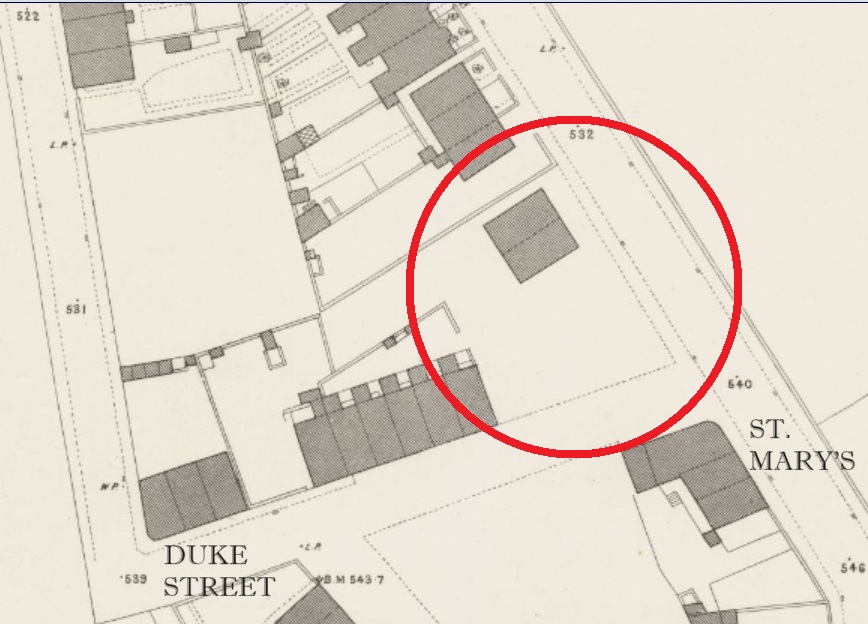
They don’t appear on the 1880 1:500 OS Town Plan
The lack of houses is circled in red, with St Mary’s running broadly NW-SE. Map stolen, as usual, without shame, from the enormously useful and always fascinating National Library of Scotland OS map database. Check it out here.
But they do appear on the 1898 25 inches to the mile OS map:
You can really see the map filling up, and a real sense that Glossop is still filling out to its Victorian and early 20th century maximum. Map stolen as per above!
Which gives us a date of between 1880 and 1898 for their construction.
So about the name, then. It took me a moment or two to see them, but at the end of each of the corbels that hold up the guttering, you can see a letter or character.
Apologies for the darkness of these photographs… I didn’t realise quite how murky they were until they
Wow! I love this, and I cursed myself for not noticing them before – serves me right for always having both eyes on the floor! It is difficult to photograph these without a telephoto lens, but also without attracting the ire of householders, who oddly don’t like it when you stand around taking photos of their houses, usually muttering threats of ‘setting the dogs on you’; people are strange. Anyway, the best I could do is the following stream of photographs; apologies in advance!
J O H N+ T R UE M A N .
So then, what do we have?
J O H N + T R U E M A N 0
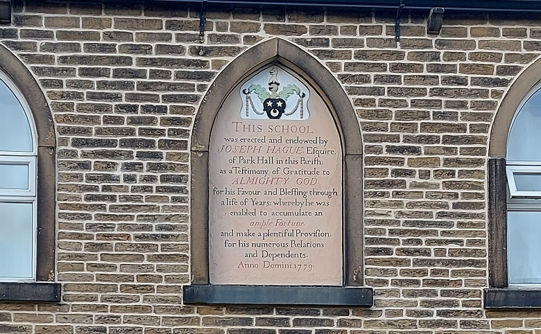
Nice! A mystery. There is very little relevant online, but there was a reference to a John Trueman as the publican of the Beehive Inn in Whitfield, which was worth following up, and hence the History in a Pint Pot advert. The connection is not immediately obvious, but the fact that Trueman was mentioned as both wine and spirit merchant, and a stone dealer in the advert suggests that he built the houses, and probably using his own stone. It seems that the position of publican of The Beehive (or ‘Bee Hive’, as it was then) came with the rights to the quarries at the end of the track beside the pub, next to Fieldhead Farm there.
The Beehive is arrowed in red, but you can see the track leading to the quarries at the end.
William Miller, the landlord in 1857, is also described as a stone dealer. Our man John Trueman was landlord here between 1871 and 1894, which is also spot on for the date of the houses. I like the idea of him wheeling and dealing, serving pints and stone in equal measure. And if you build houses, then why not go ahead and sign them, particularly in a rather cool way. There seemed to be a lot of that around at the time, and as I was walking away from St Mary’s, I remembered another named building that I’d like to take a look at – Norfolk Buildings on Victoria Street:
Norfolk Buildings and The Surrey Arms
According to Robert Hamnett, The Surrey Arms and the three adjacent houses in the terrace were built in 1846 by James Robinson, who owned a large number of houses (and presumably having built them, too). You can see the uniform design and decoration of these three, especially in comparison with those buildings to the left, which are smaller and built to a different design. You can also see the ‘join’ between the two groups. It seems that these houses were constructed later that Norfolk Buildings, and presumably by a different person – again evidence of the piecemeal process that characterised Glossop’s Victorian building boom. The name/datestone is above the centre of the three houses:
I wonder if ‘archaeologist‘ would hold up in court as a defence against being accused of being a ‘peeping tom’. An academic question, obviously… purely theoretical.
‘J.R. NORFOLK BUILDINGS 1847’
The ‘J.R.’ is presumably James Robinson, and the buildings named after the Duke of Norfolk, whose investment in the town was arguably at it’s greatest in the mid-19th century. The date speaks for itself, though Hamnett notes that the lease for the pub dates from 28th March 1846, so this might be a lease connected with the land itself, or perhaps the proposed pub.
So there it is, this month’s offering… and I made it in January! There are so many Victorian datestones in the Glossop area, many recording details beyond just a date, and we find house names, builder’s names, area names, and the like. I’d like to do another survey of datestones or name plaques for the Victorian period, to accompany the one I did (and is still ongoing) for the pre-Victorian period. Or, you know, convince one of you to do it and publish it on the website (if you fancy the challenge, give me a message). Anyway, more again very soon.
In other news, the first issue of Where/When is back in stock. So, if you fancy a guided Wander from the Friendship Inn to The Oakwood, via Ashes, Dinting, Adderley Place, Pikes Lane and Harehills, and through the prehistoric, Roman, and medieval periods, then this is the publication for you… especially if you like what you read here!
You can download a free copy here, but there’s nowt like a physical paper copy: £5 from Dark Peak Books, on High Street West on Glossop (and I might be the one to serve you!), or you could just ask me, and I’ll bung one to you. For those that have been asking, Issue 2 is on the way… and honestly a fantastic one it’s going to be.
I’ve also got a few actual different Wanders planned, real actual physical walks led by yours truly, up hill and down dale, and through our amazing shared historical landscape. You can even throw stones at me when I start to bore you about pottery… and no, that doesn’t mean you can sign up for it just to lob rocks at me, Mr Shouty-Outy. Anyway, watch this space as I’ll advertise it her, and elsewhere.
So that’s about it for now. Hopefully I’ll get a couple written for February – I have so many half-finished articles it’s ridiculous, and I just need to get on with it (lots of pottery goodness!). But until then, look after yourselves and each other, and I remain.
I’ll not beat about the bush, let’s get straight to business! Over the past few months, when I had time, I spent some entertaining hours poring over any and all parish and other records relating to Glossop. Not just that, but estate records, royal tax records, and wills too… anything with a place and a date, essentially. I have been trying to establish the first mention of the farms and places that make up what we know as Glossop in order to get a feel for the place in the 16th, 17th, and 18th centuries. Why yes, yes I am that interesting.
Parish records were first introduced by law on 5th September 1538. From that point on the details of any event that took place within the church had to be recorded, and thus anyone baptised, married, or buried (hatched, matched, or despatched) were entered into a ledger (here is a good introduction to the subject). The details depended on the event, but it usually included a name, a date, and, crucially for us, a place: e.g. 14th June 1620, Jonah Wagstaffe, son of Charles and Elizabeth of Glossop, was buried.
What follows is an alphabetised list of the locations mentioned in the parish records for Glossop All Saints parish church in Old Glossop. I primarily used the North West Derbyshire Sources site, run by the seemingly unstoppable Marjorie Ward. The website is an absolute goldmine of data for this area, so please do check it out. Also, all credit, and huge thanks, goes to the people who originally transcribed the parish records; it wasn’t me, and all I did was read them and extract some information – I merely stood on the shoulders of giants, to quote Newton (and others).
Glossop’s records don’t go back as far as 1538, sadly, but instead start in 1620. Why this should be is unclear, but it is not the only example from around the country; opposition to the process, a lack of direction, and simple laziness may all have played a part. Because of this, I also looked at any other forms of official records I could find – tax records, wills, land deeds, and what not, to see if I could push some dates back further. I will be adding to these data in future, especially as I come across earlier references to places, so think of this as a work in progress. I have used the modern spelling for the places, but have made a note of different spellings when they appear. Until relatively recently, there was no standardised spelling of words, and placenames in particular were spelled how they sounded, often reflecting the accent of the people, as is the case here (see Coombes and The Heath for good examples of a local accent preserved in the records).
Note that this is simply the first mention of these places, not the date they were founded. This may seem obvious, but it is important to state that many of these places will have been settled for hundreds of years prior to their mention in the Parish Records. This is underlined by looking at how many of the entries have a date of within 20 years of the 1620 commencement of the parish records – it is clear that they didn’t all just pop into existence at that point, and that the first mention of them here is just that. A big boom in the settlement of the area would have commenced in the 1530’s after Glossodale was taken from Basingwerke Abbey and given to the Talbot family – it would be in their interests to get as many rent paying farmers on the land as possible. That stated, the abbey was pretty good at making money and would certainly have encouraged the foundation of farmsteads, thus we can perhaps characterise the period following the relaxation of the forest laws as one of continual expansion.
A note on the sources: PR – Parish Records. Domesday Book – is fairly self explanatory. 1381 Poll Tax – information taken from the book ‘The Poll Taxes of 1377, 1379, and 1381’ by Carolyn Fennick (Glossop only features in the 1381 Poll Tax, oddly). Wills – from the North West Derbyshire Resources website. Kirk – papers of the Kirk family of Glossop and Chapel-en-le-Frith. Datestone – the datestone on the house. EPNS – any of the numerous records used in ‘The Place-Names of Derbyshire Vol. 1’ published by the EPNS. EPNS – Ch – is ‘The Place-Names of Cheshire Vol.1‘. Derbyshire Subsidy Roll 1327-8 (DAJ) – Another poll tax, published in the Derbyshire Archaeological Journal of 1908 (read it here, if you like). Roll of Fines – a list of people fined for offences against the forest, and dated to the 13th year of Edward I (1285), you can read it here (it’s the same source as the Forest Rolls (EPNS), but I have mined some more information that the EPNS left out). Shepherd’s Society – the list of members of that society that met in Glossop and Longdendale (read it here). Shrewsbury Papers – the public record office collection of the Earls of Shrewsbury’s papers (the Talbot family archive, essentially) – here.
Place
Date
Person Named
Notes & Alternate Spellings
Source
Almans Heath
1650 (22/7)
Burial of Elizabeth Timplie, widow
“Almens Heath”
PR
Ashes
1674 (12/11)
Marriage of William Newton & Mary Newton
PR
Bank
1668
Bank Farm on ‘The Bonk’
Unpublished Ryland’s Charters (EPNS)
Bankwood
1717
Hadfield. “The Bankwood” (Gate) (Bankswood)
Rylands Charters (EPNS)
Bettenhill
1637 (24/3)
Burial of Elizabeth Robinson, wife of Robert
“Betterside Hill” “Betterside the Hill” “Bettinside Hill”
PR
Blackshaw
1600
Will of Ottiwell Beard of Kynder (John Dande of Blackshaw is witness)
Wills. Also the burial of Anna Dande, wife of John 1621 (PR)
Bridgend
1598
Will of William Barber of The Heath (Robert Bramhall of Bridgend is witness)
“Bridgent”
Wills. Also, Burial of Ann Brammall 1654 (PR)
Brown Hill
1285
“Brunhill”
Forest Rolls (EPNS). I’m not convinced, to be honest – Brownhill is a common name, & the physical evidence does not support 1285. Reference to “Sarah Hollinworth alias Brownehill” in 1624 might be this place. Definitely, though, Thomas Garside in 1807 in SS
Castle Hill
1692 (2/2)
Burial of Edward Hadfield (snr)
PR
Charlesworth
1086
“Cheuenwrde”
Domesday Book
Chunal
1086
“Ceolhal”
Domesday Book
Cold Harbour
1627 (23/5)
Marriage of Otwell Clayton & Margaret Downes
PR
Coombes
1285
“Chiselwrthecumbes” (1285), “Cowmbes”
Forest Rolls (EPNS). Also baptism of Anna Bridge, daughter of John 1644 (PR)
Coombes Edge
1700
Burial of Elizabeth Booth
“Colmes Edge” Same as Cown Edge below?
PR
Cow Brook
1643 (24/3)
Baptism of Joshua Dewsnap
PR
Cown Edge?
1702
Baptism of Sarah Booth
“Cold Edge” “Coln Edge”
PR
Crosscliffe
1555
Edmund Bower of Whitfield
Lease in DRO (D5236/5/27) Also 1608 Calendar Rolls (EPNS)
Deep Clough
1285
“Depecloxe” “Dupecloh”
Forest Rolls (EPNS). Also baptism of Nicholas Brammall 1620 (PR)
Dinting
1086
“Dentinc” (1086), “Dintinge”
Domesday Book.
Fieldhead
1804
Will of George Roberts (mentioned land at ‘Field Heads’ – presumably the same)
The position of Fieldhead Farm is literally that, at the head of the ploughed selions, now simply fields.
Wills. Also will of Jacob Hollingworth 1845
Gamesley
1285
“Gameleslegh”
Forest Rolls (EPNS). Also Tax of Jurdan de Gamesley Derbyshire Subsidy Roll 1327-8 (DAJ)
Glossop
1086
Domesday Book
Hadfield
1086
Domesday Book
Hargate Hill
1623 (10/7)
Burial of Widow Robinson
“Hargatt Hill” “Hargett Hill” “Hardgate Hill (1654)” “Hardgate” might refer to a ‘Hard Road’, i.e. not muddy track. Roman? The road does pass by here.
PR
Heath
1285
John del Heath
Also as “Teathe” (3/11/1658) (PR)
Roll of Fines. Also Robert del Heth, Derbyshire Subsidy Roll 1327-8 (DAJ)
Herod Farm
1703
Datestone
Hilltop
1679 (27/7)
Burial of John Hadfield
Caution… there is also a Hill Top in Chisworth (EPNS).
PR
Hobroyd
1327
Wills de Holberode
“Hob Road” “Hobrod” – road rather than royd?
Derbyshire Subsidy Roll 1327-8 (DAJ)
Hollinworth Head
1546
Hollingworth Head Farm
Unpublished documents in the Middleton Collection (EPNS). Also burial of Emmot Taylor, wife of Ralph 1623 (PR)
Hurst
1550
“Whitfield Hurst”
Feet of Fines (EPNS). Also baptism of Robert Hagh in 1621 (PR)
Hurstnook Farm
1772
Datestone
Jumble
1640 (1/4)
Burial of Grace Turner, wife of Reginald
“Jomble”
PR
Lamyclough
1629 (8/12)
Burial of William Newton, son of Hugo
“Lammanclough” & “Lammeclough” – Charlesworth way
PR
Lane Ends
1623 (14/12)
Burial of John Robinson
Whitfield
PR
Laneside
1625 (14/9)
Burial of John Bramall
PR
Lee Head
1706 (12/1)
Burial of Thomas Harrison
Charlesworth
PR
Lees Hall
1285
Jo. de Legh (of Whitfield) (John de Legh)
Also Ricardus del Lees 1381 Poll Tax
Little Padfield
1711 (5/1)
Baptism of Elizabeth Creswick
PR
Long Lane
1696 (24/6)
Burial of ‘Old Widow’ Boedon
Charlesworth
PR
Long Lee
1621 (17/9)
Burial of George Hyde
PR
Mill Town
1643 (27/6)
Burial of Margaret Mellor, wife of Ralph
PR
Monk’s Road
1290
“le Cauce” (The Causeway)
Calendar of Charter Rolls (EPNS)
Moorside
1616
Will of Thomas Hollingworth of Moorside.
This may be Moorside in Chisworth, confusingly.
Wills. Also burial of Widow Hollinworth 1623 (PR)
Moregate
1655 (2/4)
Baptism of Helena Hadfield
Hadfield
PR
Mossy Lea
1623 (5/1)
Burial of Ellina Hollinworth
“Mosseley” & “Moselee”
PR
Mouselow
1628 (16/11)
Baptism of William Newton
PR
Over Deep Clough
1709 (19/1)
Burial of Henry Hadfield
PR
Padfield
1086
Padefeld
Domesday Book
Pike’s Farm
1780
Datestone
Priest’s Pastures
1616
Petition to the King by a “Nicholas Hatfielde”
“Prist Pasters” – Padfield somewhere.
Shrewsbury Papers, Folio 147 (no date, but the recipient, Gilbert, died in 1616, so before then). Also 1640 (20/2) – Baptism of Anna Hadfield (PR)
Pyegrove
1631 (15/1)
Burial of Anna Booth, daughter of Ralph & Anna
“Pigreave” “Pyegreave”
PR
Reaps Farm
1631
Burial of William Hadfield, son of William & Helen
“Reape”
PR
Ringstones
1623 (13/5)
Baptism of Thomas Roobotham
PR
Rowarth
1285
Roger le Ragged de Roworth
“Rouworth”
Roll of Fines. Also Burial of Elizabeth Goddard, wife of Robert 1626 (PR)
Shaw
1285
Mathew del Shawe
Roll of Fines. Also Henricus del Schawe 1381 Poll Tax
Shelf
1285
Possible location of Monastic Grange?
Forest Rolls (EPNS).
Shire Hill
1285
“Shyrhull”
Forest Rolls (EPNS).
Simmondley
1285
Alward de Symondesly
“Symondlee”
Roll of Fines. Also Burial of Joanna Beelee, w. of William 1620 (PR)
Spire Hollin
1700
“Spire Hollin estates” mentioned for sale in D513/M/E/374 with others.
Kirk Estate Papers #374. Also 1734 Poll of Derbyshire (EPNS)
Storth
1578
Harry Booth of Storth Farm, Simmondley
He had dispute with Lord Talbot & went to London to see Queen Elizabeth I.
Historical record. Also Baptism of Joseph Botham, son of Henry & Mary, 1638 (PR)
Calendar of Inquisitions Miscellaneous (EPNS). Also baptism of Joseph Bramall 1628 (PR)
Woodhead
1424
Cholmondley Deeds (EPNS – Ch). Also baptism of Anna Bostocke 1629 (PR)
Woodshead
1654 (13/9)
Baptism of Elizabeth Heawart
“Woodsheds” in Charlesworth
PR
Wooley (Bridge)
1286
Court Rolls (EPNS – Ch)
And there we have it. Obviously buildings within these areas will have separate dates, but overall we can begin to picture Glossop as it was in the medieval and post medieval period.
Visually then, it looks like this:
This is the situation at Domesday – 1086 – with all the names villages marked in red.
By 1285, Glossop looked like this:
The monks of Basingwerk have it, renting it to the Talbot family who are encouraging people to farm, making money for themselves in rent and produce.
By 1450, very little has changed:
Just Hobroyd Farm has been added.
Following the Dissolution of the Monasteries from 1538 onwards, the land becomes the sole property of the Talbots who continue to encourage the founding of farms. Here is the situation by 1620:
The area is becoming filled in.
100 years later, the land is full of smaller farms, all paying rent to the landords, now the Howard family. The explosion in farms may be connected to the Howards drawing up longer rental leases, allowing people to invest in buildings and land not just for themselves, but for their children and grandchildren. Here is the situation in 1720:
Obviously, this is a very broad study – I just want to get the information out there. There is an awful lot more that could be done here, not least of which could be some form of more formal survey of the land deeds. It should also be pointed out that many farms will have disappeared over time, forgotten about or subsumed by larger farms, and what we have here is not a 100% accurate reflection of Glossop, merely a snapshot.
More research is needed indeed… but for now, I’m going to have a snifter of the stuff that cheers.
Right-ho, that’s your lot for this time. Next time I promise more pottery… I know how much you’ve missed it. Until then, take care of yourselves and each other.
What ho, wonderful folk! Summer is almost upon us, and we enter the finest time of year. Now don’t get me wrong, I’m fond of spring, and autumn is good. Even winter with it’s cold and dark can be lightened and warmed with a good fire and a glass of the stuff that cheers (if taken in the right dosage, as I am often reminded by the good Mrs C-G). But no, ask old TC-G which season he likes most, and the answer will always be… summer. This time of year fills me with a particular joy; it puts a spring in my step, a smile on the old fizzog, and a stirring in the loins (although that’s possibly the onion soup I had for lunch). Summer is indeed ‘icumen in’.
And indeed, it’s the stuff that cheers that leads us to today’s blog post – something a bit different, but fret not dear and gentle readers, for when have I ever steered you wrong?
I wonder then have you ever found yourself, glass in hand and perhaps swaying slightly, in a place to which you never set out to journey? I certainly have (and no, not that Turkish bordello… for the last time, I was only in there to ask for directions to the post office). No, a chance encounter with a place, perhaps exotic, otherworldy, strange and alien, like no other place on earth, and yet familiar? A few months ago I found myself, quite by accident, in The Globe pub quiz (and good evening JS!). It was a difficult quiz, and involved much mashing of the old B, and a distinct straining of the dashed M… if you catch one’s meaning.
But one question in particular flummoxed me: “How many Glossops are there?”.
I mean, there’s an existential crisis… what? Why surely there is only one? The singular, unique, one-of-a-kind place that we call home. This royal throne of kings, this scepter’d isle. This earth of majesty, this seat of Mars, this other Eden, demi-paradise. This fortress built by Nature for herself against infection and the hand of war. This blessed plot, this earth, this realm. This Glossop. (ok, I might have had a bit of help with the words there… my thanks to William what’s-his-face).
But no… apparently there are three. Who knew? Well, the quizmaster did. And several of the other teams did, apparently. But I bloody well didn’t. Not that I’m bitter or anything. And besides, none of the other teams could answer any of the questions in the ‘Pottery Identification’ round (alas, if only such a wondrous beast existed… one can but dream).
So then, two other Glossops… blimey, there’s a thought. What wonders could these places offer us, what unearthly delights akin to the Globe quiz? Well, dear and gentle reader, let’s find out.
Introducing Glossop Number 2
Where the red pin is, lies another Glossop, on the other side of the world.
Glossop, South Australia. A town roughly 250 miles north east of Adelaide (and just a mile or so north of the splendidly named township of ‘Winkie’). It’s a small place, with a population in 2016 of just 984 (compared with our Glossop’s 33,340 in 2021), mainly rural, and surrounded on all sides by vineyards – it’s right in the wine growing region, lucky people! (and presumably then the weather would be a tad warmer than that found in our corner of North Derbyshire!).
I am in awe of its triangular shape!
It was founded in 1921 as a settlement for returning soldiers, and is named after the equally splendidly named Vice Admiral John Collings Taswell Glossop (if anyone knows their Jeeves and Wooster, this could be Tuppy Glossop’s uncle). Vice Admiral Glossop was in command of HMAS Australia during the First World War, and was very active in the Royal Navy’s Australian wing.
A little different from High Street West, this is Campbell Street, Glossop.
There looks to be some great camping and hiking to be done in the area, and there are several national parks based around the Murray River there. That stated, there’s not a lot more to say about the place, to be honest, but do feel free to have an explore on the internet, or in real life (oooooh, a tour of the wine country could be fun!). If you live in Glossop, Australia, and have stumbled upon this site, then please let yourself be known – we’d love to hear from you.
But wait, there’s more!
In New South Wales, Australia, there is a Glossop Reservoir. Situated near to the village of Linden, 40 miles NW of Sydney, it’s located at the end of Glossop Road, and absolutely smack dab in the middle of nowhere.
Glossop reservoir is the round thing at the end of Glossop Road.
I wonder why they have the name Glossop? Perhaps also connected to our man Vice Admiral Glossop? There is no more information I can find out about this place at all, so any information you have would be gratefully received.
And now for Glossop Number 3.
Will this Glossop be a throbbing metropolis? A mecca of marvelousness? A seething mass of humanity? A place of culture and wonder, or a modern-day Sodom and Gomorrah? Well, not exactly…
Ladies and gentlemen, welcome to Glossop, Manitoba, Canada.
What wonders await under that red pin?
Well, what can we say about Glossop, Manitoba.
Well, no matter how you feel about Glossop, Derbyshire, it has something going for it. And as small as Glossop, South Australia, is, it has life… in that people actually live there. Glossop, Manitoba is… well… a road, next to a rail track. With some grain elevators on it.
Glossop, Manitoba… what can I say?
There must be something nearby… surely. Let’s look down the road:
Nope, nothing this way, let’s look behind us…Nope, nothing.
What we can say is that it is situated 604m (1982ft) above sea level, is on the trans-Canadian Yellowhead highway, and is broadly equidistant between the settlements of Newdale and Strathclair… both of which seem to be quite nice, if on the small size (population “perhaps 200” and 709 respectively). What we can’t say, however, is why this place has the name Glossop, although presumably it’s named after someone with that surname.
However, a little more digging and… it turns out the grain silos are interesting.
Copyright Steve Boyko, and borrowed from this website.
Well… ok, let’s be honest for a moment, anyone who has ever read anything on this website knows that the word ‘interesting’ is very flexible (and honestly, we have stretched that word to the limit on this site), and I’m painfully aware that my particular niche interest doesn’t ring everyone’s bell. But even by our own relaxed standards, these grain elevators aren’t exactly riveting. However, this is exactly the sort of thing the internet was invented for – people with niche and minority interests meeting each other and sharing information – after all I’m here writing this, and all six of you (including Pablo in Puerto Rico… hola Pablo!) are out there reading it. The website ‘Grain Elevators of Canada’ has a whole page dedicated to those at Glossop, Manitoba, but I’m not going to steal their thunder, instead please do go and have a look at it.
But wait, there’s more…
Some 350 miles north east of Glossop, Manitoba, is Glossop Lake.
Even by Canadian standards, this place is in the middle of nowhere: 40 miles NE of the nearest settlement (Pikwitonei, population 55), and 150 miles east of Thompson, the ‘capital’ of northern Manitoba (population “fewer than 15,000”). You could only get to this place by hiking for several days, or possibly by boat. It is truly remote.
Which makes it particularly baffling that the only information about Glossop Lake available on the internet are from a Wikipedia page written in Cebuano, a language spoken almost exclusively in the Southern Phillipines… and with no obvious connection with an obscure lake in the frozen north of the Canadian wilds! Bizarre!
So what can we say about Lake Glossop. Well, it’s a shallow lake, situated 200m above sea level, and covers an area of 1.35km2. It is mostly pine covered, and the average temperature for the area is -5… so you’ll probably not want to go skinny dipping any time soon. There is neither a photograph, nor an explanation as to why it is called Glossop Lake, though presumably again named after a person.
So there we have it – the many Glossops of the world. I’d like to do a roadtrip to find these places, but honestly… that seems like a lot of hard work for very little reward! However, if anyone is going to any of the places mentioned, please let me know.
And whilst this post is not overtly archaeological, it does have some relevance. Gamesley, Simmondley, and even Glossop itself are all named after people, and all were imposed on the landscape by Anglo-Saxon settlers. What the native British (the ‘Celtic’ Romano British) called the area, if it had one, is lost to us (Dinting being the exception). This habit of naming after people or features in your own language can also be very helpful in identifying settlement patterns, ages, and the origins of the people doing the naming. And here it does get interesting. Simmondley means “the clearing” (or ley) belonging to someone called either Sigemund or Sigmundr. The former is a Saxon name, but the latter, however, is a Norse (Viking) name, and that might be important. I have a pet theory… we know that a small group of Scandinavians were allowed to settle in the hills to the east of Manchester, and there are a cluster of possible/probable Scandinavian names in the Simmondly area: sitch, storth, gate, nab, and possibly others. It makes me wonder if Simmondley’s origins are more Viking than Saxon. Just a thought, but it does illustrate the importance of names in a landscape. I’ll expand on this another time.
But for now, take care of yourselves and each other.
(And apologies to those of you who have ended up on this website expecting to find an informative article on the seed of the Phoenix dactylifera.)
What ho, magnificent readers! I trust you are all rude health as we stumble toward the season of goodwill and whatnot. I love this time of year, when the cold wind blows, and the… What’s that? What do you mean “get on with it!”. Honestly, the nerve of some people.
Righty ho. Datestones. Who doesn’t love a good datestone? I mean, what’s not to love? A little snapshot of the history of a building, a birth certificate if you will, recording both the date of birth, and, if we’re lucky, the parents too.
Normally, though not exclusively, located above the door, these carved stones preserve the date of construction and the initials of the person or family who paid for its construction. The are by and large the reserve of the aspirational ‘middle classes’ of society; the poor man doesn’t build his house, the rich man has a house that speaks for itself. Indeed, it is a statement to others: I have wealth enough to build this house. They seem to become popular in the 17th century, as the ‘yeoman farmer’ becomes a class of person, that is, a person who owns the land they farm. Indeed, it may be a result of that phenomena, a way of setting themselves apart from the simple tenant farmer, who doesn’t own the land he works. Glossop has several 17th century examples remaining, though many more will have been lost, sadly. They do show up, occasionally, as the one found by Glossop Brook at Harehills Park did, and which was saved and cemented into the brook wall. Interestingly, this example also shows that whilst datestones can be a boon to historians, they can also present problems if we are not careful. They can move easily, and be attached to other buildings giving a misleading date, as is the case there, and at Hall Fold Farm. Also, stones can be put in place to commemorate a rebuilding or alteration to an existing building, causing similar, if opposite, problems.
By the Victorian period it was common to put a date and/or name on a house you built, and a careful look at many rows of Victorian terraces around Glossop will reveal names and dates. With that in mind, I have restricted my research to those datestones that carry a date prior to Victoria’s reign, pre-1837. The following is a table of the ones I know about:
There are 28 datestones in the Glossop area (broadly defined), but there will be more lurking that I don’t know about, either attached to the building still, or lying in a garden. This blog post will concentrate on the examples from Whitfield, as it is turning into a much larger post than I had thought. Plus, in the interests of honesty and transparency… I haven’t got photographs of all of them yet!
Whitfield has some of the oldest buildings in the Glossop area, and although not really much of a ‘place’ now – essentially just a ‘suburb’ of Glossop – it was once hugely important, being built along the Chapel en le Frith to Glossop road. It gradually lost it’s importance with the rise of the mills based down in the valley, the economy here being agricultural. Whitfield’s one-time importance means that we find many old buildings and a number of datestones here. Indeed, Whitfield has more old buildings that Old Glossop, which with its Church and market, was the focus of the farmsteads and settlements of Glossodale. However, important places tend to be subject to more intense rebuilding over time, whereas more minor areas maintain their old buildings. I was going to do a distribution map of the old buildings, but changed my mind for that reason. Still, it’s worth noting that Whitfield underwent a bit of a building boom in the mid to late 18th century.
35 Whitfield Cross.
35 Whitfield Cross was built in 1773 as a farmhouse, and is a Grade II listed building – see here for more details. The narrow coursed stonework and stone mullioned windows are typical of the period.
61 Hague Street.
61 Hague Street was also built in 1773, but as a pair of weaver’s cottages, and is also a Grade II listed building. 1773 must have been busy year, and Whitfield was clearly a happening place in the late 18th century. The datestone records the initials R. J. and D. Now, presumably the ‘R’ is the surname (possibly Robinson – the family being quite prominent in Whitfield) with ‘J’ and ‘D’ being the husband and wife who are responsible for the building. I have no information regarding the people, sadly, and any information would be appreciated.
Hob Hill Cottage
Hob Hill Cottage is a remarkable building dating to 1638, making it the second oldest building with a datestone in the Glossop area (after the Bulls Head in Old Glossop, dated 1607). Also built as a farmhouse, and also a Grade II listed building (there’s a theme developing here!), I suspect it might be the source of the lead came and glass, as well as some of the 18th century pottery, I found nearby, although truthfully any one of a number of buildings – existing or long gone – might be the source.
Old School House, Hague Street.
Another Grade II listed building now – the Old School House. Joseph Hague was something of an important man – indeed, the road on which the school (now private residences) sits is named after him. Born in Chunal in 1695, he rose from poverty to amass a fortune selling yarn to weavers and buying back the cloth they produced, to sell on. However, here is not the place for a discussion of his life, or of the school (the Glossop Heritage Trust does that very well here). Let us instead look at the wonderful inscription
“This school was erected and endowed by JOSEPH HAGUE Esquire, of Park Hall in this Parish as a testimony of Gratitude to ALMIGHTY GOD for his favour and Blessings through a life of years whereby he was enabled to accumulate an ample fortune and make a plentiful Provision for his numerous Relations and Dependents. Anno Domini 1779.”
I enjoy the slightly boastful “ample fortune“… well, if you have it, why not? The beautiful carved relief plaque of the beehive over the main door – symbol of productivity and hard work – gave inspiration for the name of the pub over the road. The Beehive pub itself is an 18th century building, with a 19th century front added, and another example of the building boom of the 18th century in Whitfield.
Old School House, Hague Street. The beehive carved in relief, surrounded by Sunflowers, and crawling with characterful bees. I love this. 62 Hague Street
Another Grade II listed building, one of several together, and originally built as a ‘laithhouse’, that is a building made up of a house, barn and byre/shippon in one. It is a late example of the type if the date is to be taken at face value, but there you go… this corner of Derbyshire wasn’t exactly at the forefront of architectural fashion. There is also a bit of confusion regarding 62 Hague Street. As it stands now, there is a simple date of ‘1751′ above the door. However, the listing for the Grade II building notes that “No.62 originally had datestone inscribed RMS 1757” (read the full listing here). The present datestone is fairly modern, carved perhaps to replace the missing stone, but it doesn’t explain the difference in date. I thought it worth mentioning for the sake of documentation and completion.
41 – 51 Cliffe Road
So who was Joel Bennett? Born 11 April 1791 to son of George Bennett and Martha Cooper, he came from a large and important local family. He may have been the same Joel Bennet who was excommunicated from Littlemoor Independent Chapel in 1828 for “disorderly walking and impenitency” (source is here). I’m unsure of what is meant here by “disorderly walking”, but given the hotbed of radical religion that was Littlemoor, one assumes it wasn’t the Georgian equivalent of Monty Python’s Ministry of Silly Walks. He may also have bought Kinder Lee Mill in Chisworth with his brother James in 1823.
House at the bottom of Cliffe Road (4 Cross Cliff?)
This house, set back from Cross Cliffe almost at the bottom, has a wonderful datestone: stars, wheatsheaves, and a Masonic compass, with the letters ‘R’ ‘R’ ‘O’ and ‘S’. Actually, is that an ‘O’? Or perhaps a flower? I have no information about the place, nor the letters (Robinson again?), and one cannot simply knock on a door and say “What-ho… tell me about your house”. One tends to get stared at, with vague mutterings about “setting the dogs on you”, and “lunatics disturbing the peace”. Alas. If anyone has any information about this house, or indeed any of the houses, drop me a line.
Also, and seriously, if anyone knows of any more datestones that aren’t in the above list, and which date from before 1837, then please let me know. I’ll credit you, too, so you can be famous… to all 11 of you who read the blog (including Juan in Venezuela).
Oh, and some news. I’ve been working on the Glossop Cabinet YouTube account recently, and hopefully will be producing videos of me finding bits and pieces, mudlarking, talking archaeology, exploring, playing with pottery, and much more (can anyone else hear that groaning noise every time I mention pottery?). So if you like the blog, then you’ll love this. I’ll post a link asap.
Also, I’ve recently set up a Ko-Fi account which allows you lucky folk to ‘virtually’ buy me a drink if you wish. There is no pressure to do so, obviously; I do the blog because I enjoy doing it, and am constantly amazed that other people enjoy reading it (which is reward enough, it really is). However, if you do fancy buying me a pint to say cheers, I’ll never say no – please click this link, and mine’s a red.
That’s all for now I think. I’ll post something else before Christmas, possibly pottery related, you lucky lucky people (there’s that noise again). But until then, I remain,