Archaeology · Bench Marks · Graffiti · Standing Stones

Gateposts

What ho, lovely people of the blog world. I hope you are all well as we hurtle headlong into summer, each of us fearing what terrible weather will mar an otherwise splendid season. Nevermind, this too shall pass and all that, and indeed we must grasp the nettle by the horns, or something, and make H whilst the S shines…

Today’s post is one of those brought about by happy coincidence, where a series of events conspire, almost waving at you, until you finally notice and say, loudly, “what ho… a blog post!” Or, in this case, a Gate Post. The first event was posting a few photographs on Twitter and Instagram (@roberthamnett on Twitter, and @timcampbellgreen on Instagram, for those of you who might fancy checking it out). Turns out I’m not the only one who likes a good gatepost or two. And then the next event was my seeing a tiny piece of metal in the soil whilst doing a recce for a Where/When (No.7, to be precise… Of Forts and Crosses: A Mellor Wander). All will become clear, honestly.

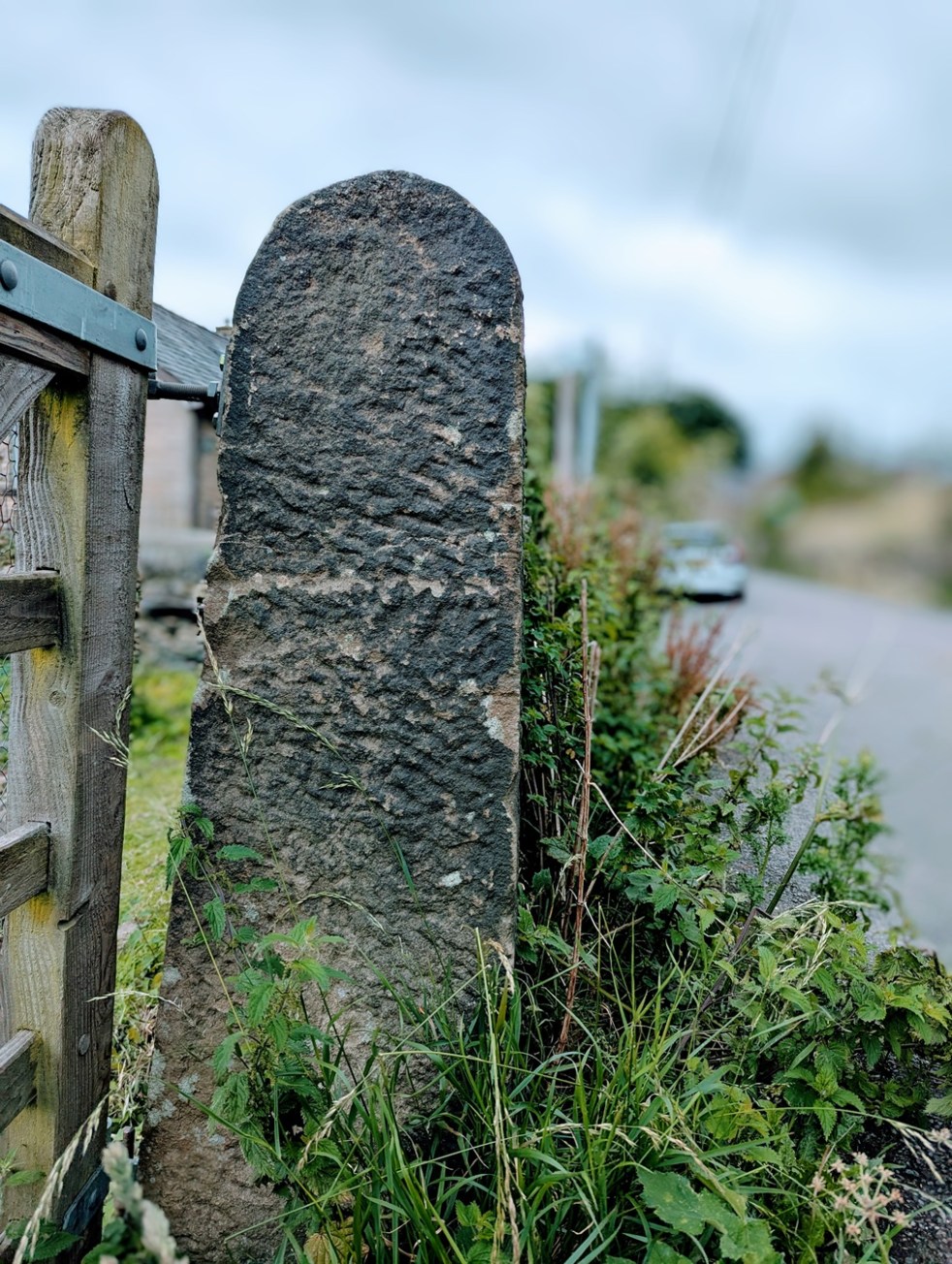
For years now I have been obsessed with gateposts. Mundane, utilitarian, and always overlooked, a good gatepost can be as interesting as a prehistoric standing stone to me, and truthfully, there is often very little difference: both made of stone, both standing upright, both important in the past, and also in the present. And if anything, gateposts have more interesting features! I mean, obviously prehistoric is fascinating, but they don’t really give us much to go on, whereas the later gateposts… well, read on.

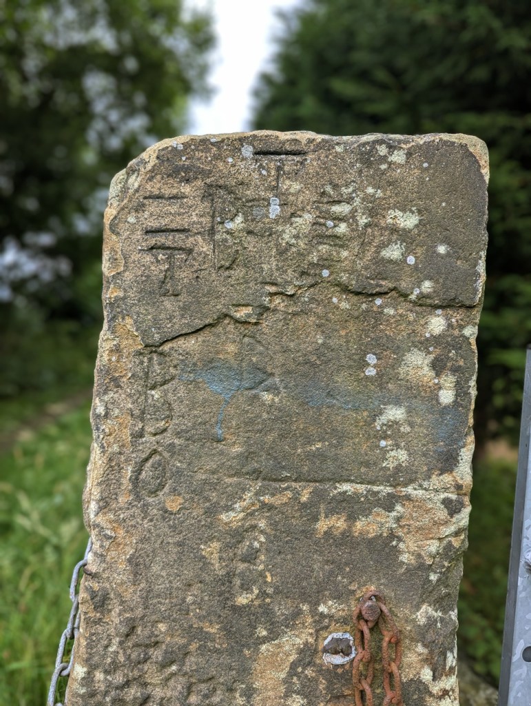
They can be decorated – often just roughly dressed.

A simple rough dressing, to shape it in a uniform manner.

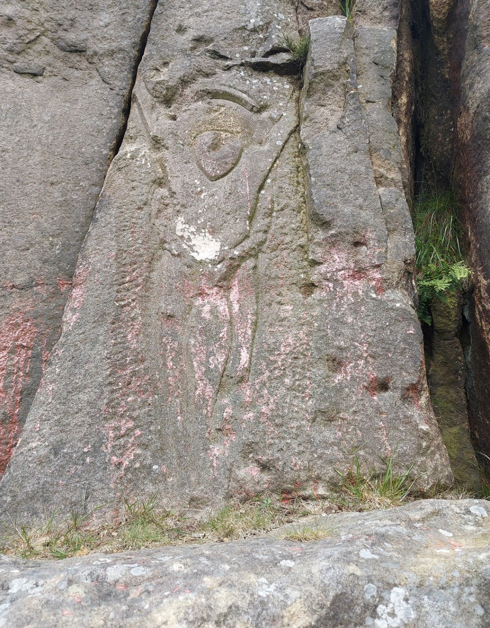
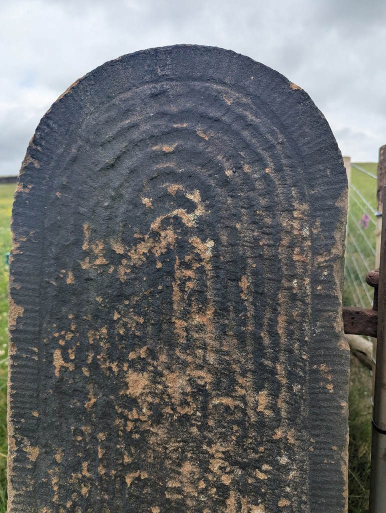
But sometimes some thought has gone into them, to create a pleasant design – which for a utilitarian functional object seemingly goes beyond what is needed.

A simple cross, surrounded by a border. I say simple… it takes some doing.

I mean, the only time you see the gateposts is when you are opening a gate to let sheep or cattle in and out, and it’s probably not something you’d see everyday. And even if you did, it’s only for a moment or two, it frankly doesn’t matter if it looks good, and I doubt farmers are wandering around making snarky comments about the plain decoration of another farmer’s gateposts. So why? What is the purpose behind them? I don’t mean they had some sort of secret meaning behind the decoration, rather they simply represent someone’s choices, but why those choices I wonder? Possibly it’s probably more to do with pride in the work taken by the stonemason who shaped it, perhaps a form of identifier: we know it’s person X who shaped it, as he always decorated it with a cross. But then there are those that go beyond simple decoration, and instead turn it into a work of art.

This is wonderful! The way it shifts from the upper band with a circular motif, to the lower aspect with the herringbone pattern is amazing. A lot of effort went into this.
This too, is truly wonderful. The circular motif, with a border, is just amazing. This post seems to be in the reddish Cheshire sandstone, which makes sense given that it, and the last gatepost was found in the Mellor area, rather than Glossop.

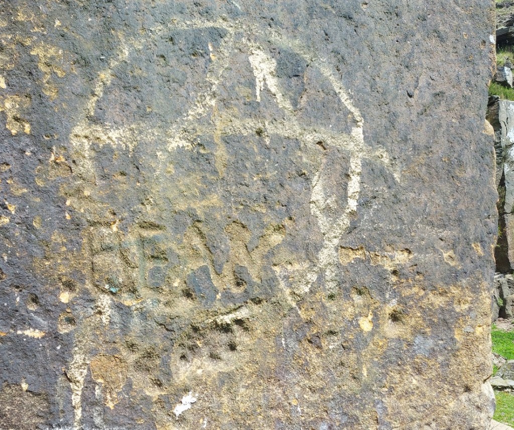
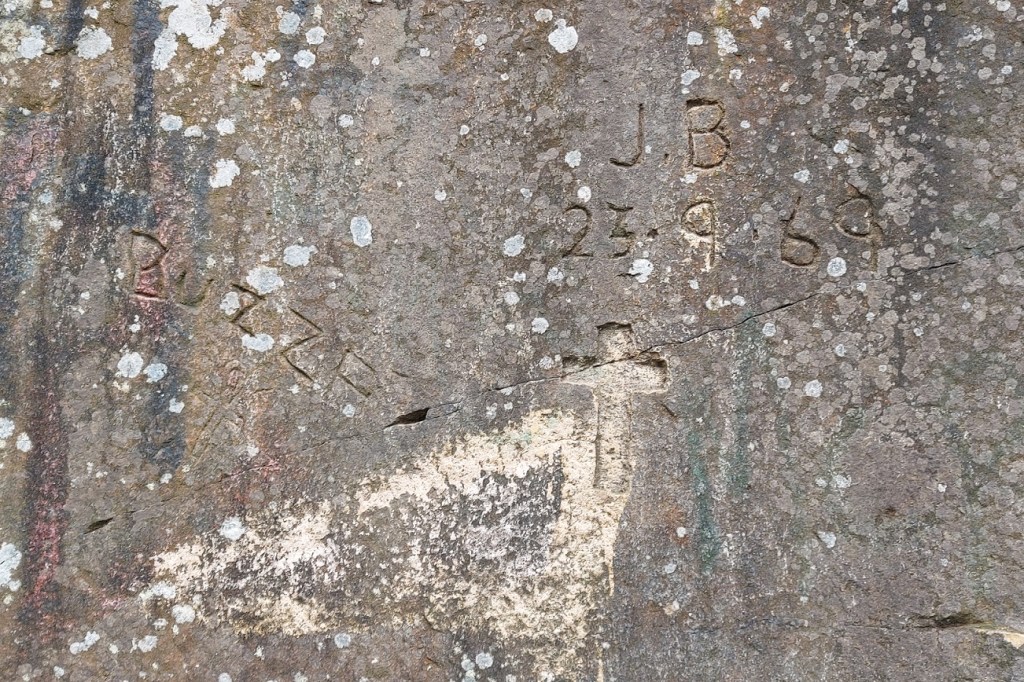
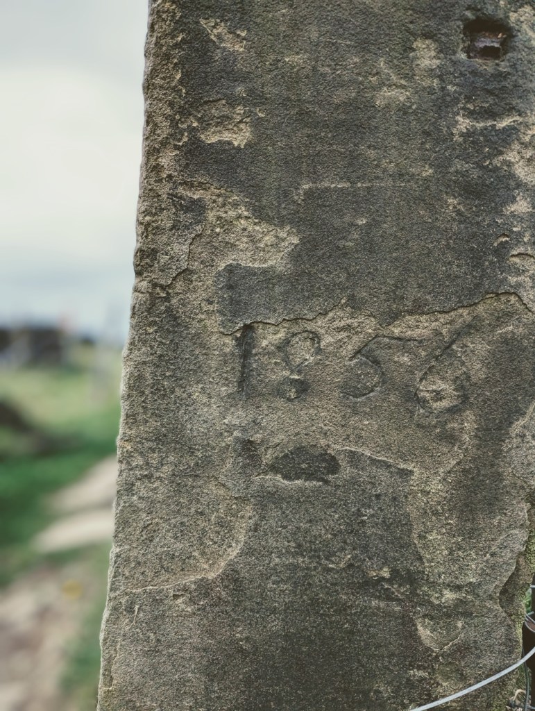
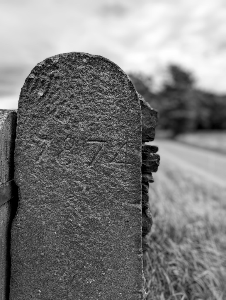
Other times, we find words and dates on gateposts. Often these are faded and barely legible, the weather and environment are not kind to these solid sentinels, and they have no shelter.

‘1856’, on the track from Fieldhead Farm to Whitfield Cross.
I went all arty with this shot… I’m quite proud of it! ‘1874’ in a very similar hand to that of the above gatepost – I wonder if it was the same person? This is on Kidd Road, just before its junction with Derbyshire Level.
Multiple ‘B’, ‘D’, and ‘O’ – from a post just by Fieldhead Farm.

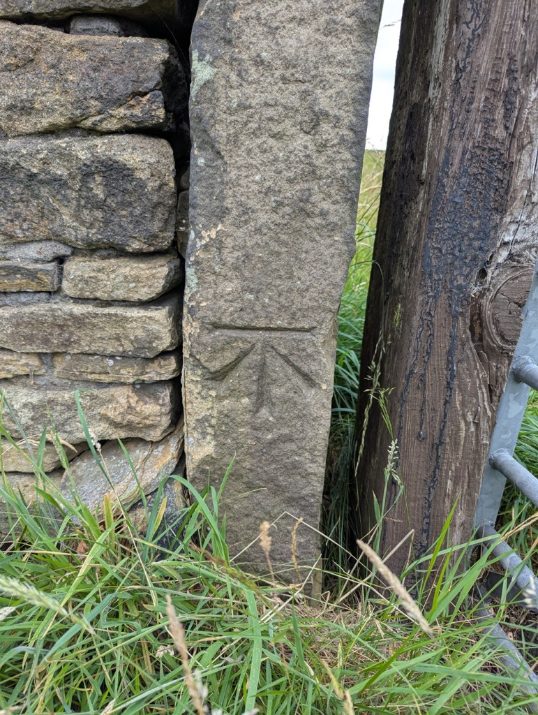
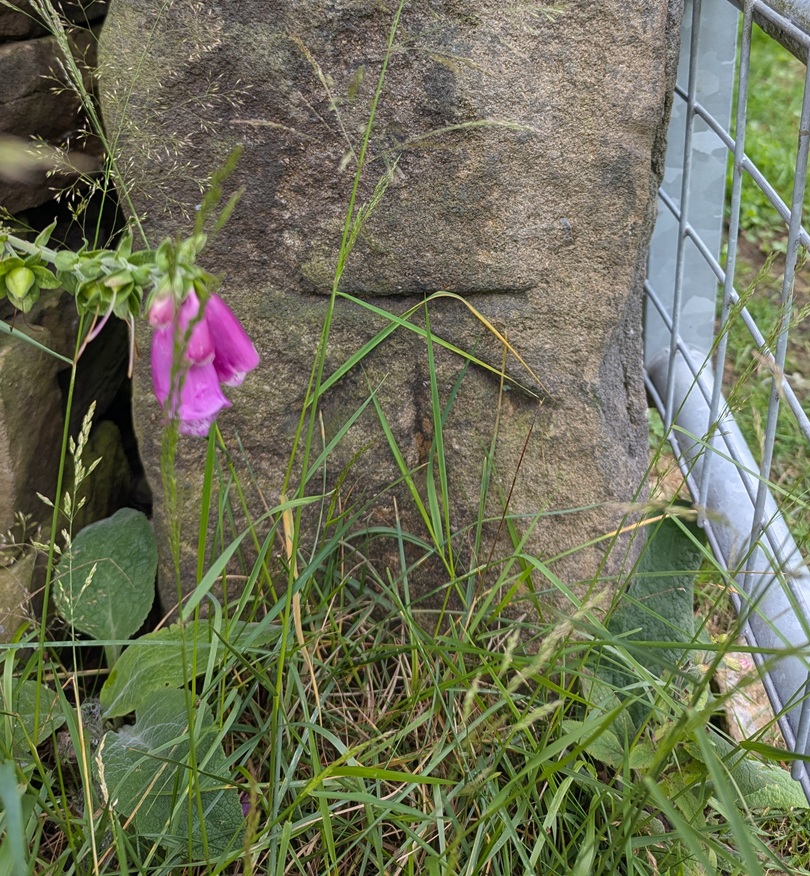
The Ordnance Survey often use them to carry benchmarks – after all they’re not likely to be moved, and so are a safe and permanent marker for heights above sea level.

The line above the arrow is 682 ft above sea level, precisely.
This one is 716ft 2″ above sea level.
I love this photo… the grass almost mirrors the benchmark. Oddly, I don’t have a height for this mark – for some reason, no OS map I have come across shows its existence. Strange.

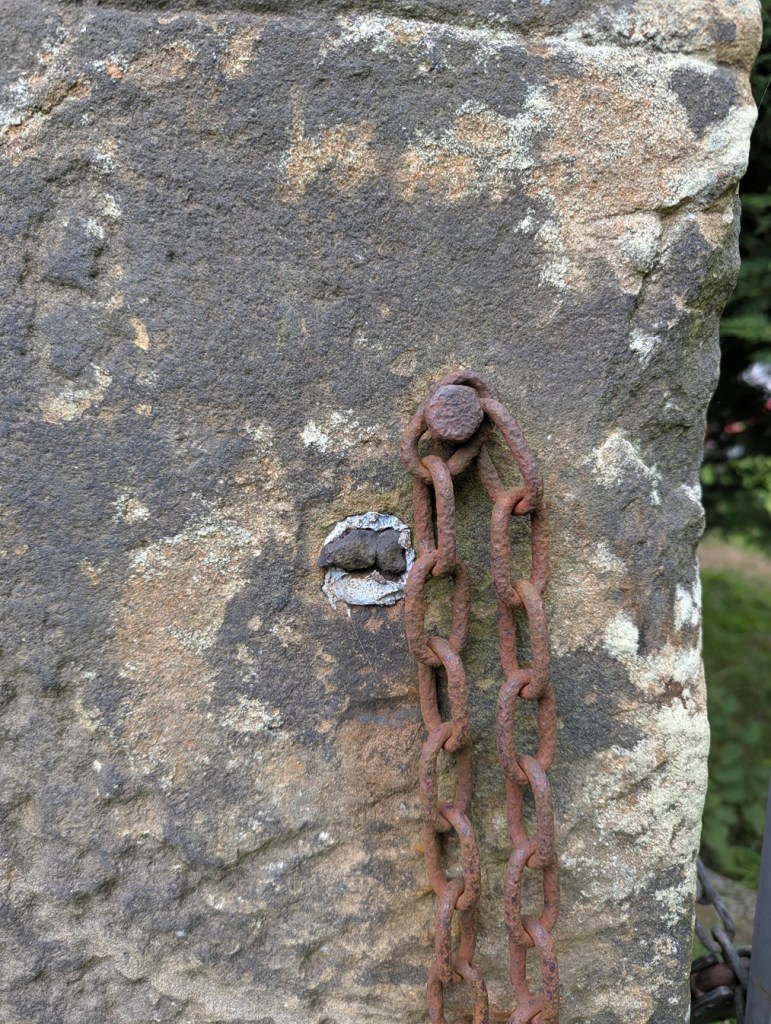
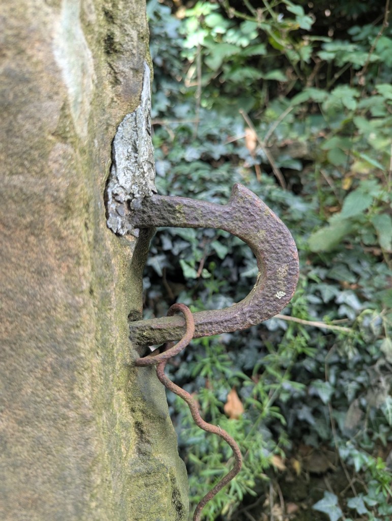
The fixtures and fittings of gateposts always fascinate me, too. Cast iron hoops and hooks, held in place by the tell tale grey/blue of lead. Sometimes you can only see the lead, the actual latch or pintle missing, it’s function no longer having purpose – it is just now a standing stone.

A now missing something or other, the metals eroding, staining the stone. It can get so bad that it actually kills the moss and lichen.
More something or other, now missing, but once important. The lead fixing is a tell-tale sign that the iron whatjamacallit is missing. I honestly love this, it really does show my theory of objects having a biography.
This is lovely… beautiful cast iron eyelet, twisted and shaped whilst red hot, and then held in place with lead. Although no longer needed to make the gatepost function – the modern steel gate does that (leaving it’s own scars on the stone) – it remains a part of its history.
Multiple phases of use, each leaving a mark.
Again, scars, but once meaning, purpose.
Hand made, and truly wonderful.

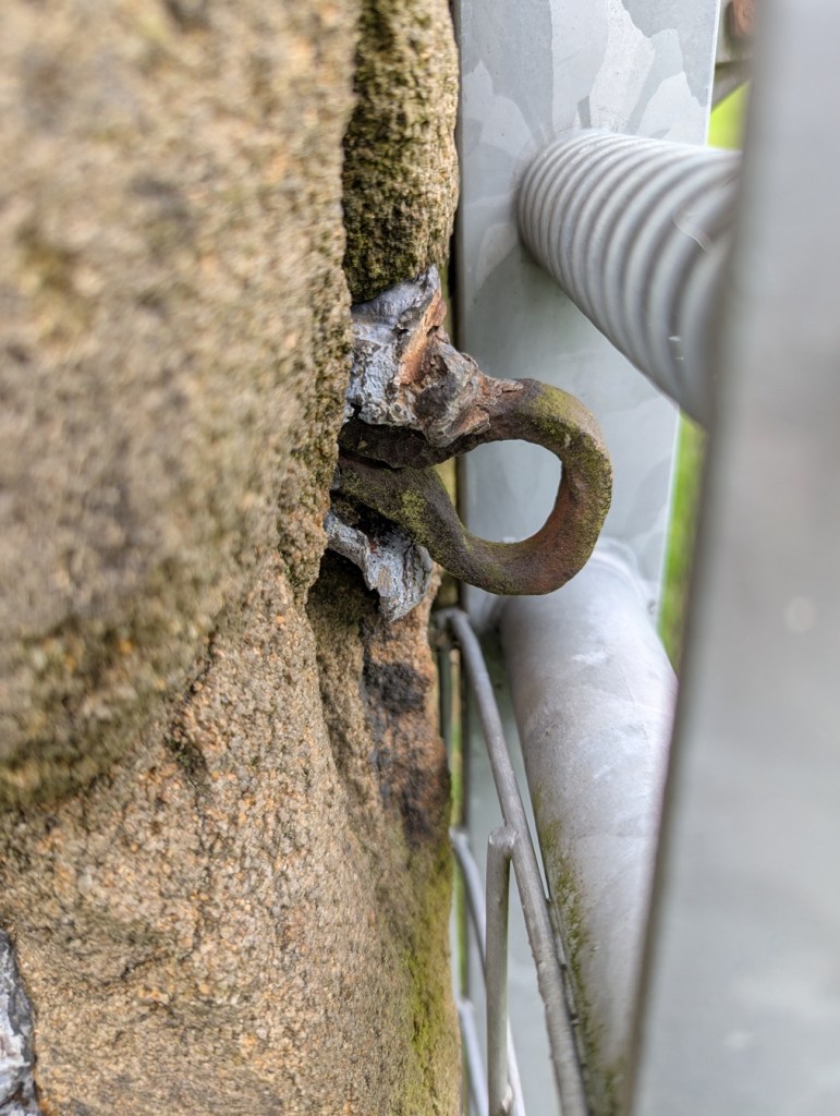
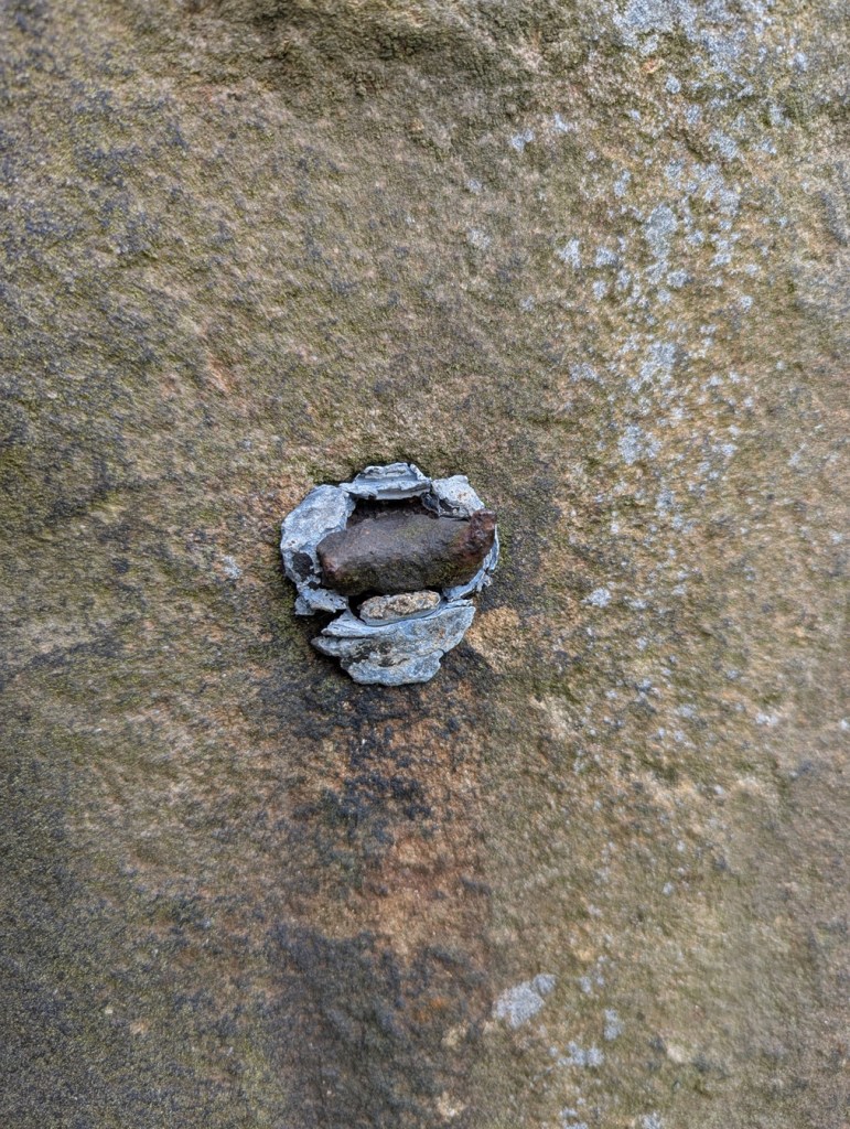
It was actually one of the lead fixings that I found that partly inspired this post. I saw what was obviously lead sticking out of the ground, and bending to remove it as I always do – it’s really not good for the environment – I realised it was bigger than I expected. I studied it for a moment trying to work out what it was, when suddenly: “aha” I thought “that’s a fixing“.

You can see rust on the inside, where the iron whatsit was held in place.

Looking at this lump, and using a small diagram, you can see what it is and how it worked. The long hollow through the middle once held the iron fixture – a pintle or latch, perhaps.

The iron whatsit was circular in section.

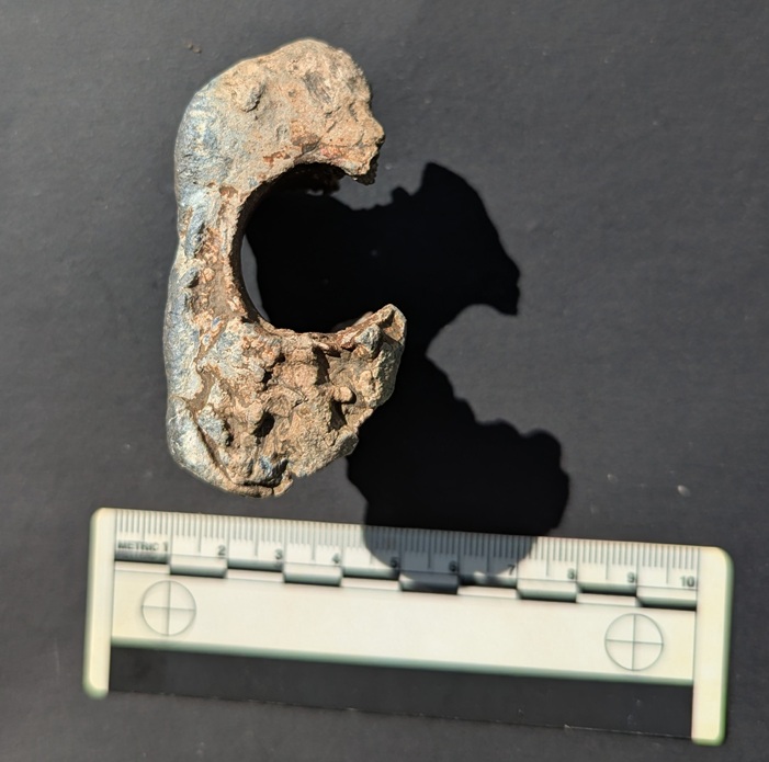
The shape of the lead piece is also a clue to how it actually held this in place. A hole is made into the side of the gatepost that needs the ironwork on it, with the lower part of the hole made deeper. The ironwork is placed in the hole, and the molten lead poured in using a funnel to hold it within the stone and around the iron whilst it cools.

If this makes sense.

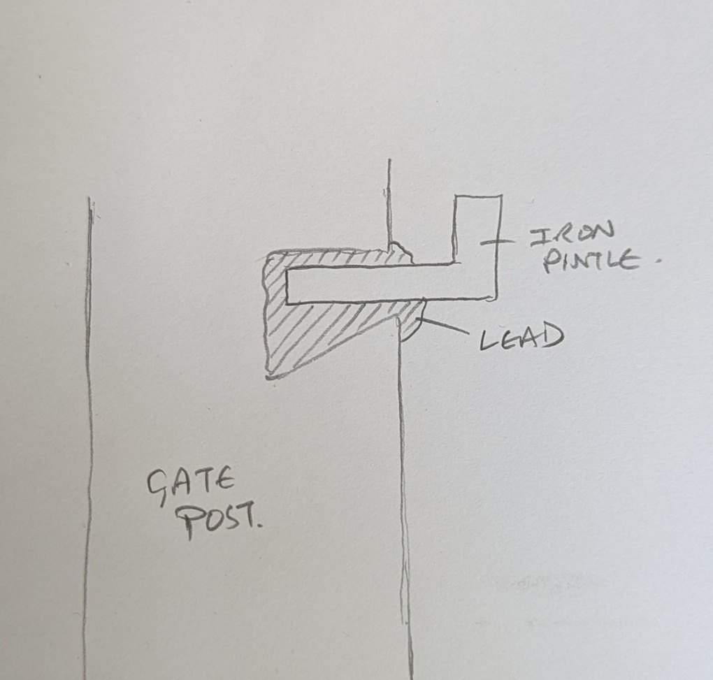
When hardened, it forms a plug that is very difficult to move, keeping the iron work in place; clever, and elegantly simple. It’s also nice to see the ‘inside’ of the gatepost, or rather a cast of the inside, and one wonders why the lead has come away so intact from its original home – one can only imagine that the post itself was broken, freeing this fixing, which then found itself at my feet in the wilds of Derbyshire years later.

In terms of dates for these gateposts – well, it’s not clear. I think the more uniform stones, with a rounded head, are Georgian and Victorian – later 18th and 19th century. However, there are some that I think are significantly older – 17th, 16th, even 15th century, possibly. These are generally less formally worked, are shorter, and importantly are characterised by having a single straight hole through the stone a few feet above the ground.

Another arty shot, this one of the ancient gatepost on Hague Street.
Carrhouse Lane, Whitfield. And no, I didn’t stick my hand in the hole…

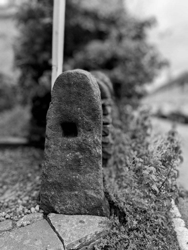
I was, until fairly recently, convinced that these were marker stones for trackways, the square hole perhaps taking a wooden pointer. However, I started to notice that this didn’t always fit the pattern, and despite multiple blog articles, twitter posts, and it even published in Where/When, I began to doubt this explanation. I then received an email that pretty much confirmed it for me (thank you PB, you amazing man!). In it, the author quoted a John Farey, whose 1815 book – General View of the Agriculture and Minerals of Derbyshire: With Observations on the Means of Their Improvement. Drawn Up for the Consideration of the Board of Agrigulture [sic] and Internal Improvement – gave the following quote:

Anciently, the Gates in the Peak Hundreds were formed and hung without any iron-work, even nails, as I have been told; and some yet remain in Birchover and other places, where no iron-work is used in the hanging: a large mortise-hole is made thro’ the hanging-post, perpendicular to the plane of the Gate, at about four feet and a half high, into which a stout piece of wood is firmly wedged, and projects about twelve inches before the Post; and in this piece of wood, two augur holes are made, to receive the two ends of a tough piece of green Ash or Sallow, which loosely embraces the top of the head of the Gate (formed to a round), in the bow so formed : the bottom of the head of the Gate is formed to a blunt point, which works in a hole made in a stone, set fast in the ground, close to the face of the Post. It is easy to see, by the mortise-holes in all old Gate-Stoops, that this mode of hanging Gates was once general.

Of course, it made sense, despite me banging on about them being marker stones. So, please accept my apologies for this; I am not always correct, and my knowledge is always growing. And thank you PB, who brought this to my attention – this is your discovery, not mine (you can read the book here – P.92 is the quote. There are about 20 of these gatepost types I know of, with many more awaiting discovery. And I actually think these are quite significant, as if we plot their location on a map, we might get a better grip on land use in the pre-industrial period. Marvellous.

I am obsessed with gateposts, and I want you to be, too. Everytime I pass one, I check it out, and often I am rewarded with some nugget of information, graffiti, decoration, or just a blast of the past. Let me know what you find via the contact page, and let’s keep an eye out for those holed ancient stones.

Right, I think that’s all for this month, and lucky you the next post will, I suspect, be a pottery post! Woohoo! I have found lots of cool stuff recently, and it all needs writing about. As always, I have about 30 projects ongoing, not all of which is coming to fruition anytime soon, but some will emerge relatively rapidly – watch this space. In the meantime, do please check out the Etsy store, or the Ko-Fi page – and feel free to buy me a beer coffee, or yourself a copy of Where/When, or even a t-shirt!

But until next time, please do look after yourselves and each other. I know I always say that, but you all matter, and we all need to take better care of each other… the world can be scary place at times, so lets band together and help each other.

And as always, I remain.

Your humble servant,

TCG

Archaeology · Graffiti · Stones of Glossop

Naked Ladies… and a Quarry

Well that got your attention! What ho, wonderful people! What ho!

Up by Coombes Edge lies Cown Edge quarry. This quarry, long disused, contains a number of interesting, and oddly well executed, carvings on the walls. I have heard about this particular place – and its carvings – many times, and from many different people, but had never managed to get up there. No reason, simply that there are so many places to see, and so little RH. A few months ago, a friend (my thanks to Andy T) suggested a walk up that way and, well, I thought, let’s have a look.

What I like about this place is not just the ‘historical’ history, which is visible and tangible, but the ‘personal’ history which is similarly visible, but often better felt than seen. The quarry seems to be one of ‘those places‘; a destination, a space in the landscape that attracts; a shelter, an asylum, a place of freedom, and perhaps decadence. In particular, it’s place where ‘youths‘ go and be ‘youthful‘, frolicking, feeling, fumbling, and… well, you get the picture. I didn’t grow up in Glossop – I’m a ‘comer-inner‘, so to speak – but if I could take you to Cheadle Hulme where I did grow up, I could show you a few such places from my youth. Every town & village has them – and the similar stories they could tell of the first time drunk, illicit substances consumed, virginities lost, love discovered, best friendships forged, fights fought, and the always difficult transition from child to adult negotiated – often on the same evening. But perhaps most importantly, memories are made. To quote Wordsworth “Bliss it was in that dawn to be alive, but to be young was very heaven“. I have recently turned 47 (young for some of you, old for others… it’s all relative), and have been marvelling at the swift passage of time, so forgive the nostalgia. Now on with the show.

Cown Edge Quarry seems to have been started sometime in the early 19th Century, probably as a source of roofing stone. Geologically, the stone is Rough Rock – a type of sandstone of the Peak District and southern Pennines, and the most commonly occurring of the Millstone Grit group.

Incidentally, and as a rule of thumb, you can roughly date the buildings of Glossop by what the roof is made from. Prior to c.1850 roofs were made from stone taken from local quarries such as these. However, once the railway arrived (c.1850) Welsh slate could be imported on trains. Not only was slate cheaper, but it also weighed less so the roof could be constructed using less timber, and so roofs after 1850 tend to be made of this. A rule of thumb not an absolute guide, but useful nonetheless.

Anyway, the quarry is located here:

Thank you Google for the image.

And here it is in 1898:

And thanks to the National Libraries of Scotland for this image.

If you use the What Three Words app, the reference for the quarry entrance is: tribal.workers.crossword

Now, as subjects go, it isn’t perhaps the most interesting, but then as we know on this site more than most, ‘interesting’ is a veeery subjective word. However, it was deemed important enough to have its own Historic Environment Record – MDR10021. Largely overgrown now, and with none of the urgency and noise that would have marked it out as a place of work when it was operating, it is peaceful and still.

The view looking north from the quarry mouth
Looking west. Interesting, and a little odd, to think that the roof of my house, where I type these words, was almost certainly quarried from this place.

However, the walls are full of interesting graffiti, carved over the years since the place was abandoned. Some is more worthy than others, but all is a record of people, humans being, well… human. I have said elsewhere that there is something universal about the need to leave a mark on the environment, almost a way of achieving immortality, your name living on past you, perhaps. And hats off to those who did it before the invention of spray paint… if you wanted to put your name up in the past, you had to mean it – with a hammer and chisel. Here follows a sample of the carvings – mundane, as well as the more creative.

AKW 1942 – presumably there is no reason to lie about the date, so this is interesting… and asks further questions.
“Tim. Joey. Glossop”?
“.D” – quite modern, I suspect, and a worn hole.
“BEAN”? and some pock marks. These overlay – and are later than – the painted anarchy sign.
“DUF, LEZ, ANT, GUS” 1994. “KEV” at the bottom is even probably even more modern.
“DAN”, “SID”, “LES”, “LYNN”, and some symbols. These seem to have been carved and re-carved.

Talking of symbols, there are what seems to me an unusual number of Christian crosses carved here:

“BUZZB” and “JB 23.9.69” I love this one – the date is so specific. The cross is also very prominent.
An ancient Egyptian Ankh symbol – quite old (filled with slow-growing lichen), and odd to find on the rock face.
Another lichen-filled cross.

Perhaps it’s the crosses that give the quarry its reputation for Satanism and witchcraft? Anyway, the ‘religious’ iconography culminates in this, what the HER calls “a potential Calvary figure” – that is, Christ on the crucifix:

Well executed, and subsequently highlighted in paint.

This is a weird one – is it one figure, or two – a smaller, more feminine and naked, between the Christ-like figure’s legs? Or is it three? The more I look, the less I know. Is that the point? Is there a point? Even down to the almost-altar like outcrop of stone in front of the figure, this is very good.

It seems that this is a modern(ish) rendering, done by a known person – I have heard several different reasons and accounts – and people – but the story is not mine to tell, nor is it for me to name names. That I will save for the comments section, should anyone wish to do so.

However, it looks like it was the same hand that carved this naked lady, as well, so I’m not sure about any religious motivation as such:

It’s carved with skill, too.

There’s also this lower half of a person on their hands and knees.

Not sure what I can say about this… so I’ll say nothing!

Moving away from carvings, and back onto the safer territory of history and archaeology, there are traces of the original purpose to which the quarry was put here and there amongst the more modern intrusions.

The rough dressing is visible in the dark area of the quarry face.

Here we can see the rough dressing of the stone, done prior to it being broken out of the rock face. This provides it with a flat-ish surface before it is smoothed properly elsewhere. This was probably the last thing that was done in this quarry before it was shut down, as it is part of the quarrying process, but was never finished. I like that.

The quarry road, with spoil piles on the left.

The quarry road is very nicely preserved, but if you look closely at the stone at the bottom of the above photograph, you can see a groove worn into the rock there, running top to bottom. This is the track of a sledge repeatedly being drawn over the stone, day in, day out, for decades. A horse-drawn sledge is easier to use, more stable, and less likely to cause accidents, than a cart, and were often used in these remote quarries.

I also found also a concretion in the rock face of the quarry. Essentially, a concretion is a small boulder of one type of rock which is formed naturally, and which becomes trapped within the matrix of a surrounding rock when it was laid down as sediment millions of years ago.

I love that the concretion looks like an eye, the ‘eyelid’ accentuated by the red paint.

The concretion erodes at a different rate from the surrounding material, and so they stick out quite clearly. They’re fairly common in this type of Rough Rock, as indeed are plant fossils, apparently, but I didn’t see any of those… I need to go back.

Right, there you have it. More soon – including more pottery, you lucky, lucky, people. I’ve got so many ideas – walks, books, tours, blogs posts, pottery workshops, YouTube shenanigans, surveys, excavations, art, creativity, etc. – and so much I’d like to do. For now though, stay in touch and follow me here, or on Twitter (@roberthamnett), or even on Instagram (timcampbellgreen). Or just come up to me and say “What ho, Robert Hamnett!”.

But until next time, please look after yourselves and each other.

And I remain, your humble servant,

RH.

Archaeology · Oddities · Whitfield

What If…? Of Stone Heads and Stories.

What ho, you wonderful people, you.

So, despite having half a dozen half-written posts, piles of interesting objects and sherds to talk about, and a few adventures to recount, I want to try something a little different today. “Oh no!” I hear you cry. But fret ye not, gentle reader, for it is still archaeology, it is still Glossop based, and it is still interesting. But it is a little… quirky. You’ll see what I mean.

I have a friend who is a writer, and quite a good one at that. He has often mentioned that stories usually start with what he terms a “What If?” moment, where something – often an object – presents itself, and the question is posed “what if…?” From there the story grows, based on and around that one question. The answer that comes doesn’t have to be ‘real’, it is fiction after all, but it has to be possible. What if a house was haunted? And what if the house fell down? And what if a brick from the house was haunted too? And what if a dashing archaeologist took the brick home to write about it on his extremely popular and incredibly interesting blog? What if…?

Archaeology, I think, uses a similar technique. An object is excavated, and the interpretation – the story – begins. However, where we differ from writers is that we base our ‘what ifs…?’ on evidence and supposition grounded in data. The interpretation, in this sense, has to be ‘real‘, although it is only ‘real’ for as long as the data supports it. Sometimes though, It’s fun to play “what if…?” – and here we join today’s post.

A stone head displaying all the characteristic features, including almond eyes. This one was allegedly found on Mouselow, and now lives on a wall in Buxton Museum

Stone heads. A lot has been written about them. They are cursed and evil. Or they are warm and friendly. They are ‘Celtic’ (i.e. Iron Age or Romano-British) in date. Or they are medieval or early modern in date. Or a combination of both. They represent an unbroken pre-Christian tradition, and an aspect of the whispered ‘Old Ways‘. Or they are simply folk art, and just decorative. Or they are magically protective (that wonderful word, apotropaic, again). Or both. Or neither. A brief trawl of the internet gives a lot of different sites and opinions, ranging from the scholarly and the more open minded, to what can only be termed outright nonsense.

Whatever they are, carved stone heads are a feature of this part of the Pennines – from Longdendale, over the hills to West Yorkshire, and up to the Calder Valley. I actually have a serious project that is looking at them; cataloguing known examples from Glossop and Longdendale, and trying to place them geographically, as well as giving some sort of date to them. There are at least 23 examples from the Glossop area, with more doubtless waiting to be uncovered. But it’s an ongoing project, and not really ready to publish – here, or anywhere else for that matter – and I just keep chipping away at it. It was during the course of trying to map where they were found, that I noticed something very interesting.

Stone head in Old Glossop. Image stolen shamelessly from the Old Glossop website (follow this link – the website is very good)

Before we go any further, I should state that my personal belief is that most of the stone heads are medieval or post-medieval in date (indeed, there is a record of them being carved in the 19th Century). That’s not to say that Iron Age ‘Celtic’ examples don’t exist (one was found at Binchester Roman Fort, in County Durham in 2013), it’s just that it is very difficult to date them as they usually don’t come from any secure archaeological context, and basing a date on ‘style’ or method of carving, as has happened in the past, is notoriously dodgy. That stated, there is the possibility that I might be wrong. And this led to my ‘what if…?‘ moment.

Back to the find location, sadly the majority of the heads are simply “found in Glossop area“, and thus have no exact place. But from various sources, I was able to identify where some of the heads were found. The distribution map is below:

1:10,000 map of Glossop. The Find spots – where the heads were found – are marked in red.

They seem to be dotted all around the area: Mouselow, Manor Park Road, several in Old Glossop, etc. However, looking at the above map, I noticed there was a distinct grouping in Whitfield – four of them centred around Slatelands Road and Hollin Cross Lane. Hmmmmm… let’s have a closer look, then.

Here is the Whitfield group on the 1:2500 map.

Duke Street, Pikes Lane, St Mary’s Road, and Slatelands Road. Geographically, they are in the same tangle of roads in that area. But the heads more than likely pre-date the Victorian roads, so we need to strip them back. What was there then? Well fields, mainly, though the medieval track from Simmondley to Glossop ran through here (that blog post is coming, I promise!). And before that, the Roman road also ran through here, along Pikes Lane, before kinking over Long Clough Brook and onto the fort and settlement at Melandra.

And then, the “what if…?” hit me.

For the sake of a good story, what if these heads actually were Iron Age or Roman in date? What could this cluster mean?

Looking again at the area stripped of the Victorian houses, it’s very clearly a promontory, a high plateau that runs between two brooks – Glossop Brook to the north, and Long Clough Brook to the south. In the Iron Age, they liked their elevated places – Mouselow, which dominates the area, is a classic Iron Age hillfort, and others exist nearby, at Mellor and Mam Tor. One only has to look at St Mary’s Road from Harehills Park to see how steep those slopes are (try doing it pushing Master Hamnett in a pram with a load of shopping from Aldi). And on the other side, who hasn’t cursed Slatelands Road halfway up, gasping for breath. This is a very real landscape feature, completely masked by later development, but one which would have been very visible back then. This would have been particularly true where the peninsular narrows at the west, leading down to the junction of the two brooks. This too, is significant.

Throughout prehistory water was a sacred thing, and was considered ritually important. A spit of land, elevated, defined by water and ending in the confluence of two bodies of water, would have been hugely significant. Actually, a perfect place for an Iron Age temple or shrine, perhaps one devoted to the ‘Celtic head cult’ as suggested by scholars such as Dr Ann Ross (in her Pagan Celtic Britain)? Indeed, the North Derbyshire Archaeological Survey notes that the number of heads in the Glossop area “might suggest a cult centre” based in the town in the Romano-British period (Hart 1984:105). It has been suggested that the heads are sometimes associated with liminality and boundaries, and were protective. What if they were they placed facing down the peninsular, to mark out the sacred space, and to defend it?

The Roman road moves through this promontory, sticking to the high ground away from the valley floors and marshy terrain, as the Romans preferred (see map below). But what if the location of the possible shrine or temple influenced the choice of road location, ploughing through the sacred enclosure, perhaps to make a point about Roman dominance?

The location of the heads in relation to the landscape. The blue is the waters of Glossop Brook (north) and Long Clough Brook (south), forming the spit of land. The yellow line is the medieval trackway, and the green line is the course of the Roman road.

What if…?

Now, I’m not suggesting for a moment that that the above is absolutely true; this is a wild flight of fantasy, and pure fiction – a story. Indeed, doubts are being raised about the reality of the ‘Celtic head cult’ theory in general. But it is a possibility, at least: an archaeological what if…? However, if that isn’t the answer, there still remains the issue of why four stone heads were found in a cluster in this area. What is going on?

If we return to my original thought, that the heads are medieval or post-medieval in date, might they be related to the Simmondley – (Old) Glossop trackway in someway? If we look at the map above, we can see this track (marked in yellow) runs broadly along the line of Princess Street. And just to the east of the three of the heads run along the same alignment. Is this significant? What if people somehow, and for some reason, deposited these heads to the east of the track? But why? Well, I came across a possible reference to just such a practice in this area – Clarke states that “Oral tradition in the High Peak of Derbyshire suggests heads were buried as charms beneath newly-built roads, presumably to keep permanent watch over them” (1999:286). He cites no sources for this “oral tradition”, but this type of apotropaic function – preventing witchcraft and promoting good fortune – is associated with carved heads all over the United Kingdom (Billingsley 2016). Perhaps, then, we are seeing the ritual deposition of carved heads as part of the road building tradition.

What if…?

Heads
A pair of Whitfield Heads. These are at the end of Kershaw Street… and that is all I know about them. It’s on my ‘to do’ list, don’t worry.

No, it is a mystery, and ultimately we are left with questions for which there are no obvious answers. Three of the heads are in Manchester Museum, and the fourth presumably in the hands of the owner/finder. I will have to go and see them, as that might help in dating. As I say the project is ongoing, and any comments or help in the area would be greatly appreciated. Do you know of any stone heads? Do you have photographs of any? Or stories – they seem to attract folklore and superstition like nothing else! Please contact me in the usual way – email me, or through twitter ( @roberthamnett ). Or just come and find me in the street, as people are increasingly doing… so much for pseudonyms and anonymity!

I do hope you enjoyed the little flight of fantasy, but we’ll be back to business as usual next time – the sherds are mounting up! Until then, look after yourselves and each other.

And I remain, your humble servant

RH

References:

John Billingsley – Instances and Contexts of the Head Motif in Britain

David Clarke – The Head Cult: Tradition and Folklore Surrounding the Symbol of the Severed Human Head in the British Isles. (Unpublished PhD Thesis, accessed here)

Anne Ross – Pagan Celtic Britain: Studies in Iconography and Tradition

Archaeology · Folk Tales · Witchcraft

Objects Tell Stories – The Video

If you follow me on Twitter, you might know that I recently gave a talk to the Macclesfield LIT Festival with the wonderful Elizabeth Garner. It was billed as an evening of folklore and folk belief, with Liz reading folk tales from her new book, and me discussing all manner of magical things designed to protect against witchcraft. Well, it was a great event (thanks to all involved), and I think quite successful judging from the reactions.

Well, if you missed the live event (streamed from my spare room), it’s now on Youtube. We explore some interesting local archaeology, look at witchcraft and counter-witchcraft measures, and hear some great stories. Enjoy (video starts at 4 minutes).

Please also feel free to follow me on Twitter – I tweet fairly frequently about local, and occasionally not so local, interesting archaeology/history. And there is absolutely no politics, guaranteed. @roberthamnett if you want to follow me.

Your humble servant,

RH

Nothing in particular!

Twittering Tonight

With a spring in my step (tinged with fear and something like reluctance) I am moving into the 21st century!

I have finally set up a Twitter account attached to the blog. This means that I am able to post bits and pieces that I see whilst I am out and about, and without waiting to write a blog post. I am oddly excited about this!

For those of you who use Twitter, the account is Glossop Curiosities (@RobertHamnett). Feel free to follow me and to tweet me things of interest. For those of you that don’t use Twitter, fear not – the tweets themselves will appear in the side bar to the right of the blog.

RH