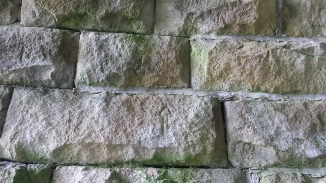
James and I went for a bit of ramble, up the hill and along Carr House Lane. Despite it being a very short distance from my house, it still took the best part of an hour… toddler speed is, I think I have mentioned before, glacial. So as I was waiting for the passing of an ice age, and hoping the clouds would stay away (they did), I began to think whether it would be worthwhile to have another poke around at the guide stoop to see if I might be able to dislodge some more stones.
It was. And I did.
I felt the last letter – a lowercase ‘l’… I think. Hang on, no. Is that something attached to it? an ‘e’? Ok, what next… Another ‘l’? … LEL?
I scrabbled around and moved more stones, all the while hoping the whole lot wouldn’t shift and trap my hand; nobody wants to be the guy on ‘Casualty‘ at whom the entire audience is yelling “Don’t be a moron, take your hand out of the wall *crash* See! Well you deserved that, idiot!”.
I could feel more letters, but I just couldn’t decipher them.
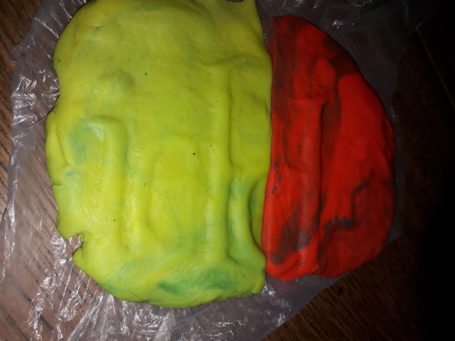
Then a series of thoughts… take a cast. James. Playdo!
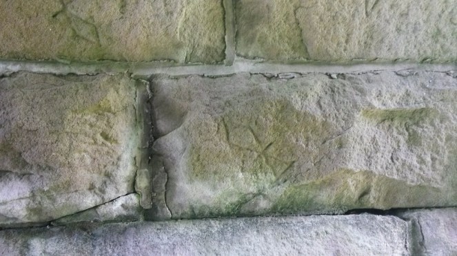
So yes, 2 hours later, and armed with a two tubs of Playdo and a sheet of thin plastic, I returned, ready to make a ‘plaster’ cast of what I couldn’t see. I have to say, it was surprisingly effective! It took a lot of furtling and fettling, but I got about as much as I could. Enough at least. So then…
Excuse the dayglow colours… blame James not me. The photo is reversed, so that it reads correctly, the original is back-to-front.
What do we have?
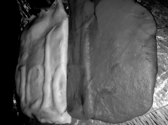
“…field“
It is a little hazy here, so I turned it to Black and White, and played around with contrast, etc. Anyway, here is the other version – between them, I think you can see the word “…field“. I hope!
It works better in Black and White from this angle. I tried taking a photo of the wall interior, but my phone ran out of battery. To be honest, I’m not sure it would have worked anyway.
So then, the placename ends in “…field“. So not ‘Chapel (en le Frith)’, or ‘Chunal‘.
So where then? And therein lies the problem! There are multiple places that fit the bill. If we assume that it is in the opposite direction from Glossop, and that it originally stood at the top of Whitfield Cross (see here for discussion), then it could be Moorfield, Hayfield, or even Macclesfield. If it stood somewhere other than the top of Whitfield Cross, then we might have to consider Hadfield or Padfield. Sheffield? Or even Whitfield… the stone may have travelled far and wide.
I have solved one problem – it ain’t Chapel or Chunal, but replaced it with another – which ‘…field‘ is it? My own feeling is Hayfield, but that’s based on nothing in particular, just reasoning.
No, the stone needs to come out of the wall!
And please, please, give me your comments and thoughts – I genuinely want to know what you think… because I have no idea!
I’d also like to say hello and apologise to the two people who saw me fettling in the wall and came to enquire if I was “alright” (i.e. not some sort of pervert sneaking around the back of peoples houses, nor a murder victim dumped in the bushes”). Thanks, and see… honest, I was telling the truth, I am an archaeologist. It was nice to meet you both!
I went for a walk with some friends a few weeks ago, from Old Glossop to the New Lamp pub in Hadfield, via Valehouse Reservoir and the Longdendale Trail. It runs along the old Woodhead Line train track there from Hadfield Station to the Woodhead Tunnel entrance. All the way along it you can see evidence of its former existence – signal cable carriers, track equipment, assorted bits and pieces, and bridges.
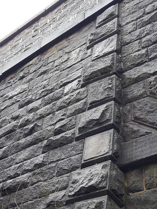
As I passed under one bridge (the Padfield Main Road) I glanced up and saw this.
Fantastic Victorian stonework on the Padfield Main Road bridge – 1840ish in date.
well, more specifically, this bit.
Close-up, but rather awful quality… I need a decent camera with a zoom lens.
High up and hidden amongst the stonework were a number of mason’s marks. Awesome, thought I.
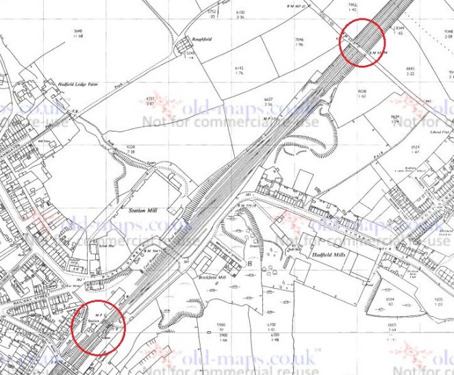
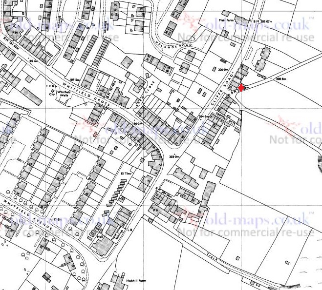
It’s here on the map.
Bottom red circle is Hadfield Station, the top red circle is where the mason’s marks are. This is from the 1968 1:2500 OS map, via old-maps.co.uk. Thanks, again!
Mason’s marks are a really fascinating aspect of stone masonry. Essentially, the stone masons were paid by the piece – the more they carved, the more they got paid, and in order to make sure they they got paid for the correct number of stones worked on, each mason signed their piece with their individual mark. It also acted as a form of quality control – if a piece of stone was not up to scratch, the master mason could see at a glance who carved it. This concept of signing your work had been going on since the Medieval period, and continues to this day. It’s not often you get to see them, as more often than not they are on the reverse of the stone, hidden within the fabric of the building. But here, for some reason, a group of masons (I count three different marks, but with perhaps another three possibles) decided to display their signs. Still, nice to see these out in the open.
Imagine my surprise, then, when we decided to go through an underpass, underneath the old track bed, and head down to the reservoir at this location, here:
Bottom red circle is the bridge with the mason’s marks, the top red circle is the underpass. This is the same map as above, just further down the track/footpath.
Wow… just wow. A grotto of mason’s marks. Quite literally, every stone was covered in mason’s marks, all of them. Outside and inside… amazing.
This is the roof… honestly, every stone is marked.
It is wonderful!
Now, I’m not sure why there is this cluster of marks on this specific underpass. Perhaps they were allowed to go wild and leave their marks in the open in this one place. Or perhaps, there was a competition between two rival gangs of stonemasons, each working to complete the stones fastest. I simply don’t know.
I have made a list of the mason’s marks.
These are the mason’s marks on the wall of the underpass.
The mark bottom right is probably a square and compass symbol – both tools are used by stone masons. It is also a symbol used in Freemasonry, which takes a lot of its signs and symbols from stonemasonry.
It would be interesting to compare them with others on the Longdendale line, to see where else these men were working here. Also, as they would be itinerant stone masons, travelling where the work is, we could compare them with others further afield. After all they are a signature, and whilst we may not know their names as such, they left their mark on our landscape. They don’t seem to match those on the bridge, though it’s difficult to make out. There have been attempts to create a database of masons marks, particularly those from the medieval period in the catherdrals. However, whilst at first glance this seems a great idea, there is flaw in the plan: there are a finite number of marks you can make with a chisel and using only straight lines. It was found that many marks were reused by different masons, sometimes separated by centuries. There is something deeply interesting about mason’s marks, though, and some are more interesting than others… Looking back at the bridge mark, I was struck immediately by the ‘M’ mark.
Apotropaia. From the Greek, apotropos, meaning literally ‘to turn away’, and more specifically in this case, to turn away or prevent evil.
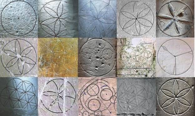
People have always used signs and symbols to act as magic charms to stop bad things, and bad people, from affecting them. Apotropaic marks became very common in the 16th-18th centuries, and any domestic dwelling of the period would have had these marks carved literally into the frame of the house. At this time, the reality of evil was not questioned, and people intent on causing you damage and sickness – witches – were a real threat and believed in utterly. Indeed, the marks are sometimes referred to as “witch marks”, and have only recently begun to be researched. I can almost guarantee that any timber framed house from the period will contain at least a few. Often they are placed by windows, doors, and fireplaces – essentially, any opening, anywhere that a witch, ghost, devil, or other evil thing might gain access to the house. The marks take many different forms, but two of the most common are the ‘daisy wheel‘ mark – usually carved into stone or wood with a compass…
The Daisy Wheel or Hexafoil mark – the idea is the evil/witch would get stuck in the wheel, and be trapped for eternity.
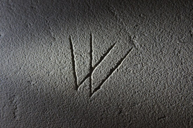
…and the ‘double V’ sign. This latter is very interesting; it is largely understood as standing for ‘Virgo Virginum’ – the Virgin of Virgins, or the Virgin Mary, and may be seen as a plea for her help.
The double V mark, or Virgo Virginum. Photo taken from here. Thanks to another really interesting blog.
Now, given that the marks are occurring at a time when it was illegal and/or extremely dangerous to be a Catholic, it is unclear what is happening here. Either we are seeing an underground following of Roman Catholicism amongst the population, which is very unlikely. Or more probably, it represents a popular belief or superstition that, whilst nodding to the Virgin Mary, is just understood as a protective symbol, without the trappings of Catholicism that would mean you were burnt at the stake. Essentially, by the 1600’s, people no longer understood the more religious meaning of the symbol, but carried on the use of it as a form of protection.
As further evidence of this, it is often found inverted, as an ‘M’, not a ‘W’. The letters are not important, the shape of the lines is.
W or M, the meaning is the same.
Which brings us back to the bridge mason’s mark
Is the mason: a) A catholic, proclaiming his faith, and marking his work thus? b) Aware of the ‘good luck’ aspect of the sign, but has no idea of its origins? c) A mason who is using it solely as his mark, with no understanding of the meaning beyond its shape?
Personally, I’m going with b, but with a small dash of c.
There is so much more to be said about this subject, it is really a genuinely remarkable field of research (and one in which I am involved), and as it is just emerging as worth studying, I urge all of you to keep an eye out for any marks on buildings, especially internally, and particularly if they are built before 1850.
Right, I have a glass of wine waiting for me, so cheers. And next time, I think some more pottery is in order. Oh, and apologies for the long post, again.
So, I finally got round to looking at the graffiti carved on the wall outside my house.
It’s a drystone wall with a flat top made of large thick stone laid horizontally. The flat surface has provided an opportunity for someone to inscribe graffiti onto it… and my, how they have!
It is difficult to see in normal circumstances, even with low light, but I applied some chalk to the whole surface, leaving the carved bits in relief, and lo! It came to life.
The chalk really brings out the carving, and washes away in the rain, leaving no trace.
I took a photo, and then messed around with the results, enhancing the contrast.
So, what can we see?
The initials P.B. and M.F. are very clear. I would suggest these were done at the same time, as they are of a similar size and are located in the same area of the stone. I need to go back and check the census returns for the house to see if anyone who lived here had those initials; it would be nice to put a name to the carving.
There is a geometric triangular design at the top – no idea what it is, but it must have meant something to someone… it’s difficult to doodle with a hammer and chisel!
There is the number ’17’ at the bottom, amongst a pile of other indistinct marks, and possibly the initials ‘J.D.’. Possibly the ’17’ could be the year 1917?
However, the biggest and best one is the ‘J.W. Ford’ framed by an archway, middle left. This is executed in a controlled careful script, almost formal, and has been thought out in advance – one wonders if the person doing it traced it out first. The archway, too, with its central boss, is very carefully carved. Actually the archway reminds me a little of the archway set over the road at the Whitfield well dressing, and I wonder if that was the inspiration, as it seems an odd thing to do, put an arch over your name.
Anyway, I shall investigate further to see if I can match up the names to people living here, via the census records. Standby for further updates.
I gave a talk to the wonderful folk at the Glossop and Longdendale Archaeological Society on Tuesday night, on the subject of Whitfield Cross. I was honestly really quite nervous. Like most people, I am genuinely scared of speaking in public, and it’s not a thing that comes naturally to me. Indeed, research seems to show that people are more frightened of public speaking than they are of death – that is, they would rather be in the grave and dead, than standing over the grave and delivering the eulogy. However, I went ahead and did it – feel the fear, and do it anyway… as the rather cliched saying goes.
I think it went rather well, thankfully. Hopefully.
Anyway, here is the edited-for-blog transcript of the talk. It builds on the original Whitfield Cross post, but has lots of new information and photographs… so please read on, even if you have read the original.
I live in Whitfield.
For those of you who don’t know, Whitfield is a distinct area within Glossop, and was mentioned in the Domesday Book as a separate settlement from Glossop (as Witfeld), and remains a parish in its own right.
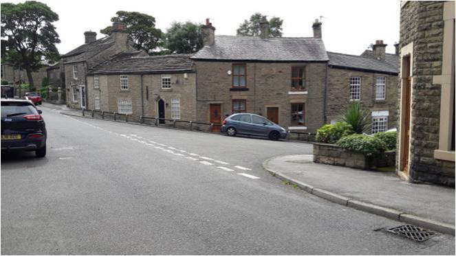
Now, my local pub is The Beehive, on Hague Street at the top – highly recommended, by the way – but in order to get to it, I had to walk up the steep hill of Whitfield Cross.
And every time I did, I pondered the name. Whitfield Cross is an odd name for a road that has no cross on it. I vaguely thought to myself, there must have been a cross here or somewhere nearby at some stage, but after a cursory scan on the internet, and a rifle through the local history section of the library, I drew a blank regarding the history of the cross. I must state that I hadn’t yet come across Neville Sharpe’s excellent book ‘Crosses of the Peak District’ which does have an entry for it, albeit a very short one.
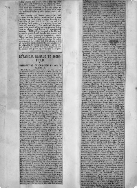
However, sometime later whilst delving into the history of the area, I came across an article by our old friend Mr Hamnett entitled “Botanical Ramble to Moorfield”, dated to about 1890.
Newspaper cutting stolen from the New Mills History Society – Visit the original via link here. With thanks.
There is not much botany, but it is an absolute goldmine of local history. And as I read the article my jaw dropped. I’m going to read you the relevant part here, as it captures perfectly what makes Hamnett so good. Plus the language is great!
“In the latter part of the last century the Cross Cliffe lads planned and partially carried out what was to them a most daring and audacious deed. One ”Mischief Night” the eve of the first of May, it was resolved to steal the Whitfield Cross. In the depth of night, when all was quiet, and the Whitfield lads were slumbering or dreaming of their “May birch”, the Cross Cliffe invaders came and detached a portion of the cross. With secrecy, care, and much labour, it was conveyed away nearly to its projected destination, but the exertions required for the nefarious deed had been under estimated, their previous work in removing all articles left carelessly in the yards or at the back doors of the good people of Cross Cliffe and neighbourhood, such as clothes lines, props, buckets, etc., etc., to their “May birch” had already taken much of their energy out of them, and, coupled with the steepness of the ascent to the “Top o’ th’ Cross,” distance and roughness of the road to Cross Cliffe, and the weight of the stone, they were reluctantly obliged to abandon their “loot” in the last field near to the pre-arranged destination. What the feelings were of the Whitfield lads on discovering the desecration and loss of a portion of their cross can be better imagined than described. The stolen portion remained in the field for some years. Mr Joseph Hague, of Park Hall, was solicited to restore the cross to its original form and position, but being imbued with a little Puritanism, he refused, and the other portions gradually disappeared until there is nothing left of the Whitfield Cross, except the stolen portion, which is now part and parcel of a stile in a field at Cross Cliffe, where the then tenant of the field placed it, over a century ago.”
“Blimey!”, I thought!
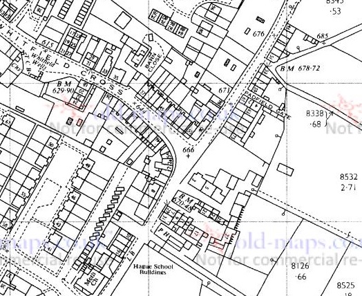
Date wise then, the removal of the cross would have been 1790 or so, and the cross would have originally stood at the junction of the road Whitfield Cross and Hague Street/Cliffe Road but we shall return to that in a minute. Cross Cliffe is at the top, along Cliffe Road, and it extends further off screen.
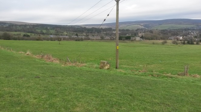
The cross would have originally stood dead centre of the above picture, inappropriately marked 666!
Upon reading this passage I quite literally pulled on my boots and headed up to Cliffe Road and went exploring. Alas, not knowing exactly where the cross was – and it is not marked on any OS Map that I have seen – I failed to find it. Weeks later, however, and walking for pleasure rather than exploring, I by chance took the correct path… and this was the sight that greeted me.
The cross is the right of the two stones. Note Mouselow Iron Age hillfort in the background.
Now, I know what you’re thinking… what exactly is it?
Well, it’s a 9th, or more likely 10th , century Anglo Saxon stone cross of a type known as a Mercian Round Shaft or Mercian Pillar Cross. There are roughly 30 known examples, with doubtless quite a few more waiting to be discovered. Originally though… who knows. Hundreds? Thousands?
Most stone cross shafts are square or rectangular in section. The Mercian variety is defined by its round or slightly oval shaped shaft. It’s difficult to understand exactly what the crosses would have looked like from the Whitfield example alone – it is particularly worn and has been defaced. However, although no complete examples survive, by studying the better preserved examples we can begin to build up a picture of how they would have looked.
So then. There is the defining characteristic shaft.
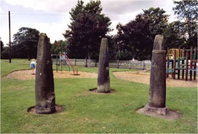
The round shafts are very obvious in this picture of the three crosses in West Park, Macclesfield. Photo and information here.
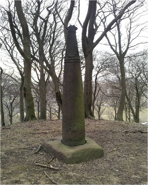
Round or slightly oval in section, and usually under 5ft in height, although some, such as that at Cleulow in Cheshire, reach as high as 7ft.
Cleulow (or Clulow) near Wincle, Cheshire.
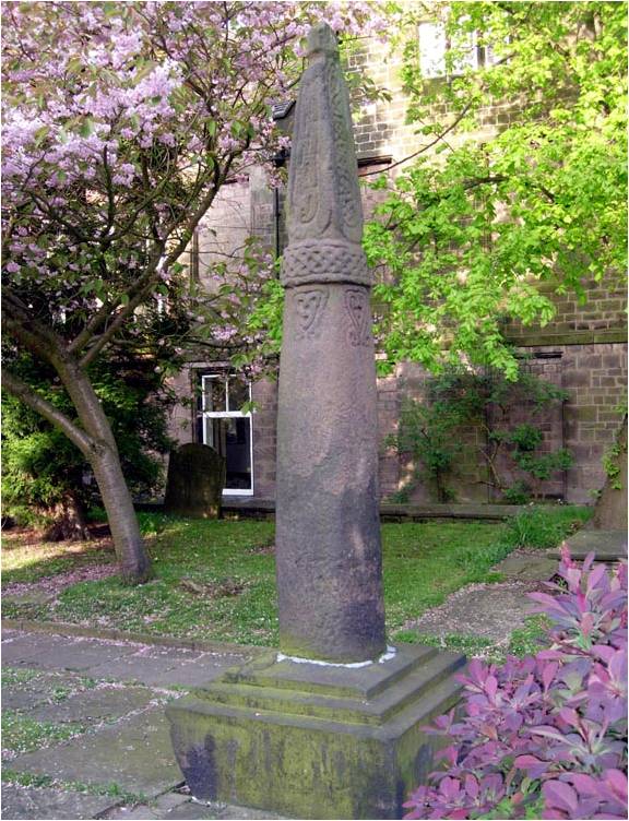
The shaft is normally plain and undecorated, although examples exist where this is not the case – Leek and Blackden for example.
Leek cross, in the churchyard of St Edwards.The cross shaft at Blackden, Cheshire. You can just make out the very worn decoration on the side of the shaft.
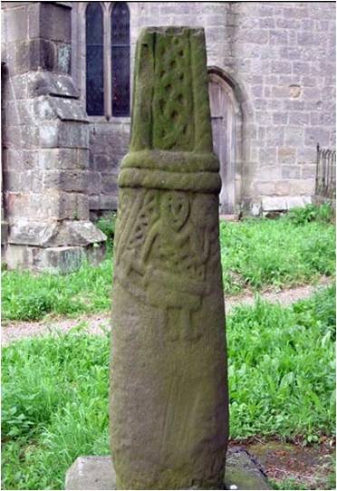
A notable example is at Brailsford, where we can see a seated solder holding a sword.
The seated soldier with sword on the shaft of Brailsford cross. Photo and much more info here courtesy of the Mellor Archaeological Trust.
The shaft tapers to a single, or more commonly, double band or collar that runs around the shaft.
A single band on the cross at Blackden.
A double band on the Shall Cross on Elnor Lane, south of Whaley Bridge (thank you David Dunford)
This band is not normally decorated, although at Leek, and elsewhere, it is (see above photograph for detail)
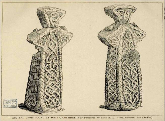
Above the band is a rectangular neck that is more often than not missing. Where the neck is present, it is normally decorated – often simply, but sometimes with complex knotwork and rope motifs such as these examples from Disley.
Ornately carved, these two were possibly once attached to the cross shafts discussed below
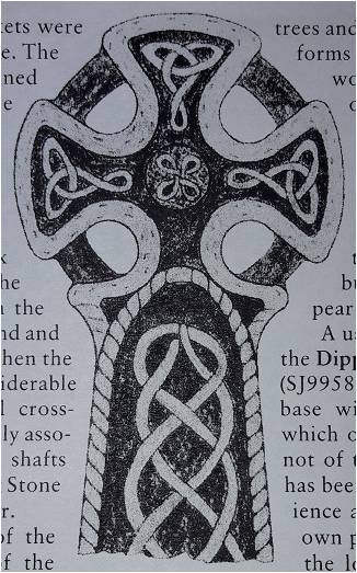
On top of this neck the cross itself would have sat. Fragments, such as those from Disley, allow us to reconstruct the cross head – it would have been a ‘wheel’ type with four arms and a central boss, perforated, and probably heavily decorated with rope and knot motifs.
A reconstructed cross head would look something like this – this is from Neville Sharpe’s book.
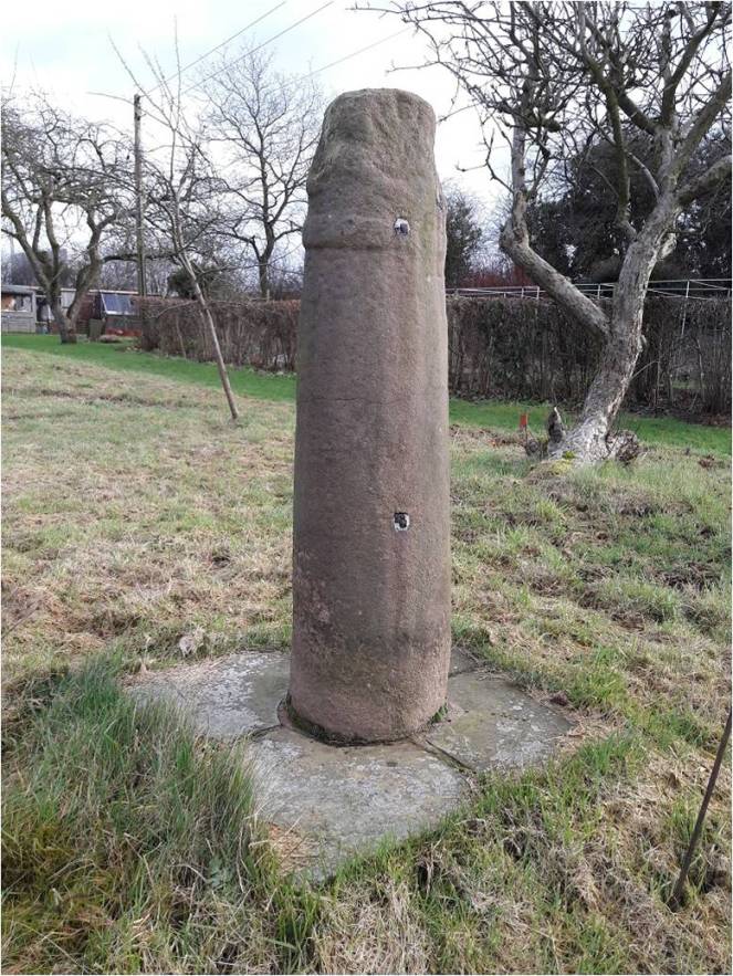
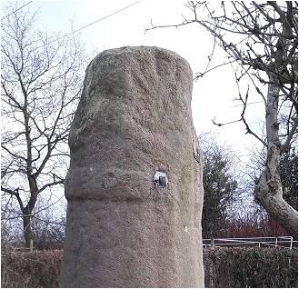
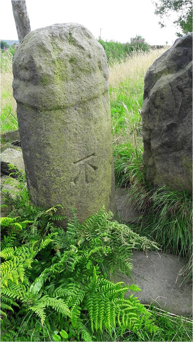
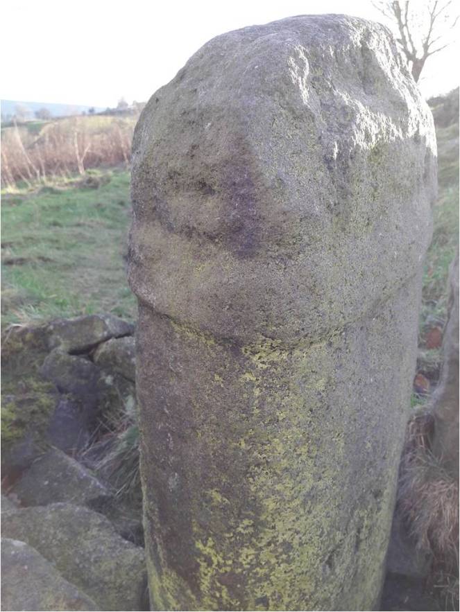
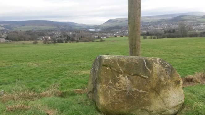
So, with this in mind, let’s look more closely at Whitfield Cross.
Note the perfectly carved Bench Mark – the surveyors had no respect for heritage! Incidentally, this one is at 682 ft above sea level.
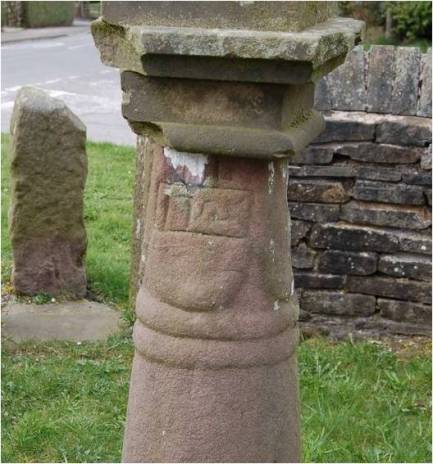
We can see immediately it is very worn. The shaft, made from the local millstone grit, is a lightly flattened round shape in section, and tapers slightly up to the collar. The collar is, at first glance, a single band. But, with the eye of faith, I think I can detect a groove running around its centre, meaning it would be a double.
A close up of the double band – you can make out the detail quite clearly here.
It is worn, but I think would have originally been something like this.
This is one of the Macclesfield crosses – we can see it’s a shallow groove, rather than a properly carved double collar.
Back to Whitfield Cross, we see the neck is worn almost beyond recognition, surviving only 6inches above the collar. However, and again with the eye of faith, I think I can detect the remains of knotwork or similar decoration.
The relief work is perhaps visible – just about.
The depressions you can see on the neck are possibly the remains of the hollow parts, the relief, of the knotwork decoration. Look again at the photographs above, and then compare with the Macclesfield example above – you can clearly see the relief work and how it would look if it was worn.
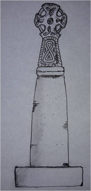
As for the cross head… we have no clue. Instead, we must rely on Sharpe’s reconstruction for guidance.
So then, and apologies in advance for the rather bad penmanship on my part – I am a good technical drawer, but an awful artist – here is my reconstruction of how the cross might have originally looked, assuming all the ‘eye of faiths’ are correct!
Reconstruction of Whitfield Cross – it now only survives a few inches above the collar.
So then, further questions are raised – the first of which is, well… what is it?
It’s a cross… obviously, but what is the meaning of it, why was it carved, and why is it here?
The urge to leave a mark in the landscape is undoubtedly a universal feeling, and one that has been with us since we humans first started ‘thinking’. Stones have often been used to leave this mark, to somehow own the land, and to act as a focus, I’m thinking prehistoric standing stones, here. Stone crosses are very much a continuation of this act of permanently stamping yourself into the landscape.
But they can convey much more information.
They were often placed as boundary markers, showing where parish, territory, hunting rights, farmland and such begin and ended. Indeed, there are many stone crosses in the area that do just that. They act as a reminder of the adoption of Christianity in the area, a symbol stating loudly that “we are Christians”. It may also have been used as a gentle reminder that “you are Christians, now” as certainly in the early Saxon periods, and with the later Scandinavian incursions, the old pagan Gods were never far away, and it was far from certain that Christianity would prevail.
However, if we look again at where the Cross originally stood, we can see another, more practical, purpose for the cross – that of marking an important junction in the contemporary roads.
So, we have the old pack horse route that comes from the south – Peak Forest, Buxton, and Chesterfield – to Old Glossop, and on to Woodhead and Yorkshire, beyond, and now called Hague Street/Cliffe Road. The cross would have marked the junction of the track that went along Whitfield Cross and Hollincross Lane, and onto Simmondley and beyond. There was another spur coming out along what is now Gladstone Street, leading to that area of what is now the town, and again onto Woodhead.
The Junction at the top of Whitfield Cross in real life.
It has been suggested that some roadside crosses were placed as a gift of thanks for the completion of a safe journey, effectively a votive offering in payment for an answered prayer (i.e. help me get home in this awful weather, and I’ll set up a cross to say thank you). They might also function as a spiritual fortifier, reminding the traveller of God’s watchful eye and his protective power over the faithful. It is easy, I think, in these days of surfaced roads, street lights, and large settlements, to forget just how dark and treacherous travelling in the pre-modern era was – making your way from A to B in total darkness, along a muddy track, and with no map as such, and knowing that if you took a wrong turn somewhere, you were lost.
There is also a further, more subtle, reason, too for the cross being here. Actually, one that perhaps wouldn’t have been that subtle when it was first carved and erected, and this reason is tied in with another important question: Who made it?
It is known as a Mercian round shaft because it occurs only in the Anglo Saxon kingdom of Mercia. However, that is to massively oversimplify the answer, and it is more complex and more interesting than that.
The Kingdom of Mercia in early 10th Century. The Peak District is the top right section.
Mercia was for a time, the dominant kingdom in Britain, but by the 9th & 10th centuries it had lost that dominance to Wessex. Even so, we can see that the kingdom is still a massive area. The occurrence of these particular cross types is confined almost completely to the northern part of the kingdom, and specifically where we are now – north west Derbyshire, east Cheshire, and northern Staffordshire: in short, the Peak District.
One of the smaller kingdoms absorbed by the Mercians was that of the Pecsaetan, literally the people of the peak, and who probably gave their name to the Peak District. They seem to have been a distinct tribal grouping, relatively autonomous, but owing tribute and allegiance to the King of Mercia. Interestingly, the land upon which the Pecsaetan farmed and lived, coincides precisely with that in which the crosses occur – Northern Mercia.
I am speculating, obviously, but it is possible that this specific cross type is a product of the people of Pecsaetan kingdom, or at least what remained of it. Moreover, this was at a time – the 9th and 10th centuries – when the Mercian dominance was on the wane – just the time that a little national pride would be in order. And thus, we may speculate that the cross – a region or people specific type – might even have become a symbol, or totem perhaps, for the Pecsaetan kingdom.
There are other examples of Mercian Round Shafts in the area. As I say, there are about 30 known crosses, give or take – there seems to be no definite number recorded, and doubtless there are more waiting to be uncovered. I note that the Derbyshire section of the book series the ‘Corpus of Anglo Saxon Stone Sculpture’ is due to be published, but without having a spare £100, I’ll have to wait until the library gets a copy to check what it says about the crosses.
Our nearest examples are Robin Hood’s Picking Rods in Ludworth, roughly 3 miles south west of Glossop.
Robin Hood’s Picking Rods.
Originally known as the Maiden Stones, these are an example of a double cross, that is, two crosses set up side by side. This seems to have been a feature peculiar to the Mercian Round Shaft, but it is unclear what the purpose or meaning of this was. The Picking Rods sit on the parish boundaries of Mellor, Ludworth, Thornsett, and almost that of Chisworth. Perhaps then, the fact there are two of them may be related to their importance in marking this out – with two different parishes choosing to erect a cross each. Another possibility is that they were originally two separate crosses, but were brought together at some stage in the past – with perhaps one of them originally marking the parish boundary for Chisworth.
There is another pairing of crosses to be found in Disley, some 10miles or so south west of Glossop.
it is possible that the cross necks illustrated above may have once sat upon these shafts.
These too have no obvious reason behind their pairing, and although they have been moved from their original site, the old, double, cross base is still there marking the place.
Other, single, examples of Mercian Round Shafts are to be found at Macclesfield, Fernilee, Bakewell, Alstonfield, and notably Leek. Importantly, at Bakewell and Alstonfield, there are large numbers of cross shafts and heads, which, suggests Neville Sharp, may be where some were made and distributed.
What then, does the cross tell us of Glossop in the so-called Dark Ages?
Sadly, not very much. The post-Romano-British period is massively under-represented in the area, to a point where it is virtually non-existent – there is the possible glass bead from Mouselow, and that is about it. And yet we know something was here as Whitfield, Glossop, Chunal, Hadfield and Padfield are all mentioned in the Domesday book – they are clearly important enough to be counted. There is also the possibility that All Saint’s church in Old Glossop has a Saxon origin, but that is currently unproven. Neville Sharpe in his book Glossop Remembered suggests that the lack of a Saxon presence in Glossopdale may be due to a lack of interest and funding by local landowners prior to the area being industrialised. This may be the case to a point, but we do see Roman material coming to light from that point in Glossop’s history, so where is the Saxon?
No, seemingly all we are left with is the monuments – Robin Hood’s Picking Rods… and Whitfield Cross.
Our single link to our Saxon past.
What the cross can tell us, though, is that Whitfield, and by extension Glossopdale as a whole, was clearly in contact with other areas of Mercia. There was no mass media, and so the particular style of cross – the Round Shaft – could only have been communicated and spread through contact and travel. Even in this insular and provincial northern part of the kingdom of Mercia, it seems that the Glossop area was very much a part of the greater Anglo Saxon world with access to all that that brought.
And there it sits, a single monument to the late Saxon inhabitants of Glossop – the most tangible connection we have with the residents of the area at that time.
And sadly one of the most overlooked.
I would love to see the cross moved from its present location and placed somewhere where it can be seen and understood by everyone, as a vital part of the heritage of the area. I have suggested before that the wells on Whitfield Cross, the road, would be ideal, but that is a project for the future.
Thanks for reading, and apologies for the lengthy post. As always, any comments, questions, or corrections are very welcome.
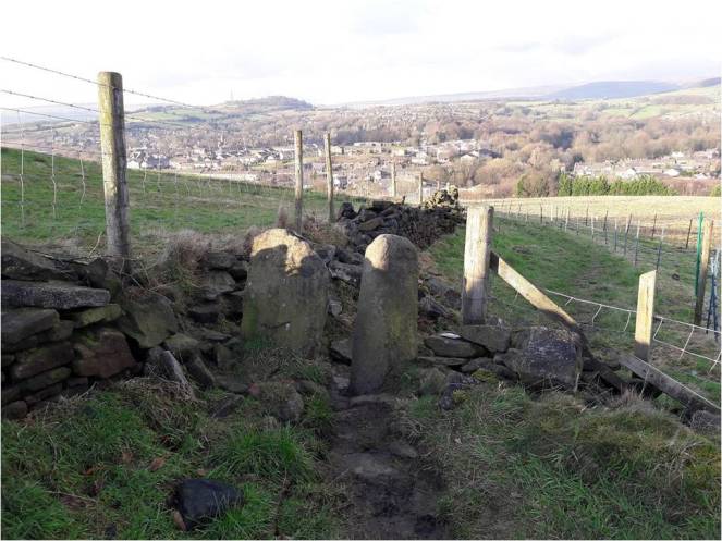
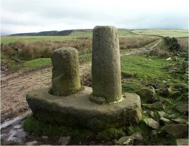
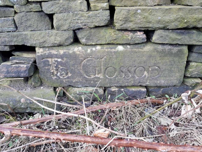
James, Mrs Hamnett, and myself went for a walk yesterday, taking advantage of the beautiful weather in the afternoon. Not a long hike – 2 year olds really don’t have a lot of stamina, and walk at a glacial pace, stopping to inspect stones, sticks, grass, puddles, clouds, etc. As we passed down the start of Carr House Lane, I looked to the left to see if I could see the guide stoop that I had been looking for since I first read ‘Glossop Remembered‘ by Neville Sharpe (highly recommended, by the way). A guide stoop is an early form of carved stone signpost, situated at road junctions, that tells you where each road goes; to use them, simply face the name of the location you want, and take the road to the right. They became common in the late 17th Century after a 1697 act of parliament, intended to improve road conditions, suggested that guide stoops were erected at junctions (There is a brilliant website about Derbyshire guide stoops here). In the book, there is a photo of a flat stone with the words ‘To Glossop’ inscribed rather ornately on the facing side. Stylistically, the date of the carving would be, I would suggest, sometime in the early 18th century.
Now, despite Sharpe telling us where it is, I have so far been unable to find it, despite trying dozens of times and in different seasons. I had begun to think that either it was firmly and permanently buried behind thick bramble and dog rose, or worse, that it had been removed and was now lost to us forever.
That is, until yesterday! Someone had attacked the bramble with secateurs, and lo and behold – the guide stoop was there!
On the left hand side, just as you enter Carr House Lane from Cliffe Road. Originally, it would have stood on a stone plinth.
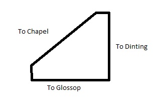
This was great news as it meant that we might have a chance to work out what the other three sides say, and thus where it was originally placed. There was some debate about location elsewhere on this site (in the comments, at the bottom here), but I was excited to be able to try and solve the problem. In short, we have a 4-sided guide stoop, with ‘To Glossop’ on one side, and, according to Sharpe, ‘To Dinting’ on another. It’s possible that Dinting is on the opposite side, but there is nowhere near that Dinting is in the opposite direction to Glossop. Plus, if we place Dinting somewhere else on the four sides, where are the other two locations mentioned? Chapel (en le Frith)? Sheffield? No, it is a bit of a mystery… until now!
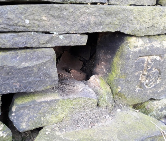
I felt along the right hand side, and with my fingers I traced an upper case ‘T’. Obviously, the start of ‘To’, but without dismantling the wall, there is no way of knowing to where. Tentatively, I removed some loose stones on the left hand side, hoping to push my hand in and be able to find the last letters of whatever place was written on that side of the square… and was shocked. It went back squarely for a few inches, and then turned abrubtly at 45 degrees. the stone was a triangle! Only three sides, and only three locations. I scrabbled my fingers along and traced a lower case ‘L’, but no more… The stone was too jammed in, and I couldn’t wriggle past it.
You can see the side turning 45 degrees to form a right-angled triangle.
I might try again at a later date, but in any case, I think we now have enough to hazard a guess as to where the places are, and to where it was originally placed.
Glossop is obvious. Dinting is likely – we have no reason to doubt Sharpe, although I don’t know how he knew that. The last… well, we know it ends in an ‘L’, so it is probably Chapel (en le Frith) – although Mrs Hamnett suggests, not unreasonably, Chunal.
This is my reconstruction of the guide stoop’s inscriptions and shape.
A right-angled triangle, in this configuration. Probably!
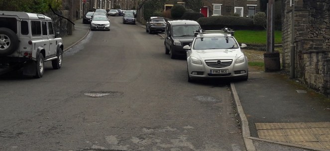
So where, if this is the configuration, did it stand? Well, simply and almost certainly, at the top end of Whitfield Cross, where it meets Hague Street/Cliffe Road.
The three-way junction at the top of Whitfield Cross works perfectly in the above configuration. Incidentally, the red blob marks the location of the guide stoop, on the left hand side going up Carr House Lane.
If this is the case, the ‘Glossop’ side would be facing south east, indicating Glossop is down Cliffe Road. Dinting is north east, accessed via Whitfield Cross, Freetown, and then Hollin Cross Lane (the old Roman road). Chapel (or Chunal) is facing south west, and accessed via the road down to Gnat Hole and then onto Chunal, Hayfield, and beyond.
The only way we would know for certain is to demolish the wall… and that would be a massive undertaking.
Just as with the Whitfield Cross, I would love to see the guide stoop restored to its place of origin – I think it would look amazing at the junction, perhaps on the pavement at the left. We really could turn Whitfield into a heritage hotspot.
As an amazing bonus, on the way back, and just by Whitfield Cross, I found this.
A marble. A literal marble.
Just peeking out of the soil, I thought it was a stone at first – it’s perfectly spherical and very tactile; a child’s toy marble. It’s stone – marble or alabaster I think, but certainly not clay as most of the Victorian marbles are, and because of this, it clearly belonged to a well off child. I wonder if it was lost on the path, or if it was lost in the city and ended up in the field as part of the process of night soiling?
Either way, it’s a hell of a find. It’s so personal and intimate – and this is why I love doing what I do.
Please feel free to comment, correct, or just chat. All is welcome.
Sorry once again to have missed the ‘one a week’ post target – I have a post in the making, which I am currently writing, but it will need a day or so more to do. My excuse this time was preparing for a job interview… which, incidentally, I got. Hurrah! I wont say what as that would give the game away as to who I am, but suffice to say I am gainfully employed in the services of a local museum, at least on a part-time basis. This allows me to continue working with the Blackden Trust, as well as spending time with my wonderful, if exhausting, son.
So, all is good in Hamnett-shire!
No, the main reason for this post is that the ever wonderful Glossop Heritage people have posted some amazing images of the Whitfield Well Dressing – see them here. These are truly amazing, and really show the size of the event as it once was.
I am really quite serious about restarting the well dressing as a new tradition – it has been stopped and restarted on a number of occasions previously, so this is nothing new. I would love to get that number of people involved, with maybe music, dancing, entertainments, food, stalls, etc. a real carnival atmosphere – although, ideally, without the traditional bull baiting, cock fighting, and prize bare-knuckle boxing.
I took a photograph this evening of roughly the same scene as the middle right or bottom left of the lower set of photographs. The original photograph must have been taken from on high, perhaps an upstairs window or something, which means it can’t be replicated properly – but it gives the impression.
Compare and imagine… Let’s do this!
I have more information to add about the well dressing, but all in good time. Anyway, enjoy this until I can get something else published.
With a spring in my step (tinged with fear and something like reluctance) I am moving into the 21st century!
I have finally set up a Twitter account attached to the blog. This means that I am able to post bits and pieces that I see whilst I am out and about, and without waiting to write a blog post. I am oddly excited about this!
For those of you who use Twitter, the account is Glossop Curiosities (@RobertHamnett). Feel free to follow me and to tweet me things of interest. For those of you that don’t use Twitter, fear not – the tweets themselves will appear in the side bar to the right of the blog.
With nothing open, the roads all but impassable, and with the wind roaring outside, it gives me the perfect excuse to open a bottle of wine, light the fire, and blog some more.
A few weeks ago I went for a walk up the hill and along the path that runs past Whitfield Cross. In the field before the cross, there was what can only be described as an infestation of moles. A big infestation… it looked like it had been bombed!
In the past I have found some very interesting things in molehills – a mesolithic flint flake, a WWI German 7.92mm bullet (in Belgium), and a sherd of 2nd century Roman pottery. I also know of a molehill that produced an Iron Age stater coin (sadly, not mine). So, I never pass a molehill without having a look.
I have to say, this haul was sadly not as impressive as that, but I’m using it to illustrate an interesting historical process, as well as an archaeological phenomenon. But first the haul.
Gifts from the moles!
Top left is a rim from a cup or similar open small vessel. Top middle is a from a glass vessel – it is a rim of some form, but is shaped in an odd way, so I think that it comes from the spout of a glass jug. Top right is a brick… plain and simple. Bottom left is a Bakelite comb fragment – the maker’s name is ‘Tudor Rose’, who, as far as I can tell, still make combs. And finally, bottom right is some cinder – essentially what is left after coal has been burned.
So not at all impressive, or even that interesting. The interesting bit lies in the question “how did it get there?”.
Any ploughed field you see, anywhere in Britain, will have a huge amount of pottery and glass lying within the ploughsoil. You can even see it at a distance, glistening in the sunlight. And most fields will have been ploughed at some stage in their history, even if they are pasture land now. So how do these items end up in the ground? There are no brick structures nearby, nor are there any coal fires. It’s an odd place for someone to comb their hair, and even odder for them to serve drinks from a glass jug into a china teacup. If these were found next to a house, the solution would be simple – they are rubbish chucked over the back fence. But this is a middle of a field in the middle of nowhere, and nobody walks into a field to dispose of rubbish.
The solution is night soil. A lovely Victorian euphemism for… well, let’s not beat around the bush. Poo.
In the Victorian and early Edwardian period, and even more recently in certain areas, no one had an inside flushing toilet. One did one’s business into a bucket that was emptied every night by the night soil man, whose job cannot have been a bundle of laughs. Also, as there was no real system for the disposal of domestic waste, if you dropped a plate, you simply chucked it into the bucket, along with glass, coal fire ashes, and anything else that couldn’t be mended or recycled. The night soil man would then come along, remove the bucket and contents, and take it away.
The larger fragments of pottery, etc. would be removed, but no one wants to spend too long picking tiny pieces of pottery out of the waste. What was left over, including the smaller pieces of pottery, etc., would be sold to farmers as fertiliser, and who then spread it onto their fields. A wonderful system of literally wasting nothing, and one that some environmentalists are promoting – better than using artificial fertilisers, apparently. Over time, a huge amount of pottery and other bits would have been ploughed into the soil, which is why so much of it is still visible.
So there you go, the story of how these random bits ended up in a field – the mole simply turned over a night soil fertilised field. I am assuming they originated in Glossop – the town was very densely populated, and there was very little by way of sanitation in the Victorian period. Most houses, being terraced, would have had a shared privy – we have our row’s privy in our garden and it is now used as a shed! But it once served 6 houses, with at least 5 people in each house by the late Victorian period – that’s a lot of night soil!
There is a place in Upholland, Lancashire, next to the canal, where barges full of night soil from Liverpool would be unloaded and spread onto a huge cobbled area there and roughly sorted. It is right next to a pub whose name escapes me, pleasant and rural now, but 130 years ago would have been very different!
Anyway, the moral of the story is always check out molehills (and also any ploughed field), as you never know what might turn up. And don’t worry, 100+ years is a long time for night soil to linger… just don’t think about it, and wash your hands afterwards, just in case!
I thought I’d venture a little farther afield this week. The blog is intended to explore Glossop’s heritage, but I feel that if I can see it from Glossop, I should be allowed to blog about it… even if it is in another county.
But don’t worry, we won’t be going to Yorkshire!
St Michael and All Angels church in Mottram dominates this end of Longdendale – it is visible from all sorts of angles, disappearing as you travel various roads and paths, only to pop up unexpectedly from behind buildings or between trees. Indeed, it’s presence keeps watch over the valley, almost as a reminder that the church watches over the people. In fact, I can see it from James’ window, on the distant brow.
St Michael and All Angels, Mottram. Photograph by Stephen Burton.
It sits on a prominence called War Hill (from the Middle English Quarrelle, meaning quarry), and is a particularly bleak place, catching all the wind that roars down Longdendale from the moors. The church itself, though severely ‘improved’ during the Victorian period (read, monkeyed around with and partly rebuilt) is still at its heart essentially late medieval in date – mid 15th Century or so. Going further back, it may well have been the site of Saxon church prior to that. Travelling even further, there is evidence in the form of cropmarks that it might have been the site of a Roman signal station connected to Melandra – a perfect place with commanding views up and down Longdendale. Prior even to that, particularly given its prominent location in the landscape, it must surely have been attractive in prehistory, though there is no evidence at present.
As an interesting aside, during the late 17th Century a whole pile of my ancestors, the Williamsons, were ‘hatched, matched, and dispatched’ here (that is, they were baptised, married and buried). The Williamson family married into the Sidebottom family who were fairly big in this area, were important in the early Industrial period, and were consequently quite wealthy. Alas, my line gradually becomes poorer, and we end up in East Manchester working in a mill, rather than owning it.
Signature of John Williamson, my great, great. great, great, great, great, great grandfather, born in 1678 in Mottram, and who married Elizabeth Sidebottom on 15th February 1703 in Mottram Church… exactly 315 years to the day, today, coincidentally, and rather spookily. I will raise a glass to them whilst looking at the church as soon as I have published this post!
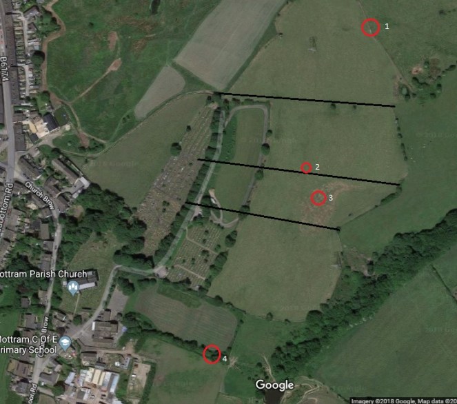
Perusing the old OS maps of the area, as I am wont to do (here), I noticed three wells in the immediate vicinity. Now, nothing unusual there, the whole area is teeming with them as we live in an area with a high number of springs. However, what was unusual is that all three, very close together, were named. Normally, a well is simply marked ‘well‘ on an OS map, but the fact that these have names could indicate that there may be more to them. And what names they are – Daniel Well, Grave Well, and Boulder Well – names that conjured up wonderful images. Well, well, well, I thought, this must be worth an investigation.
The three wells, Daniel, Grave, and Boulder, are outlined in Red. Mottram church is outlined in green in order to get your bearings. This is from the 1886 1:2500 OS map. Note also the Coal Shaft and Mottram Colliery marked – the area has a very low quality coal seam running through it that was sporadically mined in the 18th and 19th centuries.
And so it was.
Daniel Well is situated on the left, northern, side of a track that comes from War Hill along the side of the school, and downhill to a pond. Interestingly, the only artefactual evidence from this exploration came from this first part of the track, just behind the school playground.
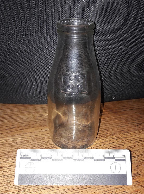
1/3 pint of Co-Op school milk in a squat bottle. This really is a nostalgic trip!
I am just about old enough to remember free school milk, and these are the bottles they came in… It has been over 30 years since I touched one of these last, and the feeling was one of immediate nostalgia and a weird sense of happiness. Silver foil top and a blue plastic straw… I was back in Bradshaw Hall Infants School, just like it was yesterday! What I love about this artefact is that the only way it could have ended up on the track behind the playground is if some naughty child threw it over the fence… if you put it to your ear, I swear I can hear the “vip, vip, vip” sound of Parka coats rubbing together and the cries of “go on, I dare you… chuck it!”.
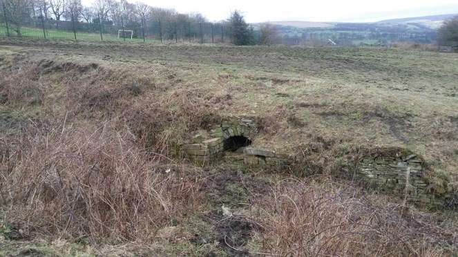
On to Daniel Well, then. The sunken path is muddy, but well constructed and was clearly used – I wondered if this was the main well for the area. My first sight of it seems to confirm that thought.
Daniel Well, overgrown and unloved. Beyond is the playing field of Mottram School, and beyond that, Longdendale.
The path widens out at this point, and the stone built well head structure stands well built still. The path is very boggy, and although the well is overgrown and possibly relatively dry in terms of water within it, the spring that created the well is still flowing freely downhill.
Close up of Daniel Well. Stone built arch, and side platforms upon which to put your buckets, bottles, etc.
The stone-built arch that is the front of the well goes back some three feet, although it is sadly now full of collapsed rubble. To me, this seems a sad end to what was one of the most vital aspects of the village – lives were, quite literally, saved with this water. Food, drink, laundry, baths, all came from this point. People who met drawing water here married in the church above, and had children. Gossip and community, focused on this place, and yet, no longer. I would love to see it restored, or just a little better cared for.
Following the path down, the water flows into this secluded and sheltered pond.
The pond from the end of the track. The water flowing into it from behind the camera comes from Daniel Well. It then flow out again through a channel to the left.
Clearly Daniel Well was an important well in the area – the path and the stone built well head attest to this. I have no idea about the name, though – possibly from a personal name of the person who owned the land? Something Biblical, maybe? Any thoughts, anyone? The 1954 1:10,00 sees the last mention of Daniel Well on an OS map, and clearly by that point it had ceased to be important as a water source. Sadly, I doubt anyone living nearby would know it was there now, or at least know that it had a name.
Making my way back up, I decided to look for the other two wells. I had studied Google maps before exploring, and took a while to work out the locations by superimposing the old map field boundaries onto the modern satellite image of the area.
4 is Daniel Well, 3 is Grave Well, and 2 is Boulder Well. 1 becomes important in the discussion below. The black lines are the field boundaries shown in the 1886 map that are no longer there to help with orientation.
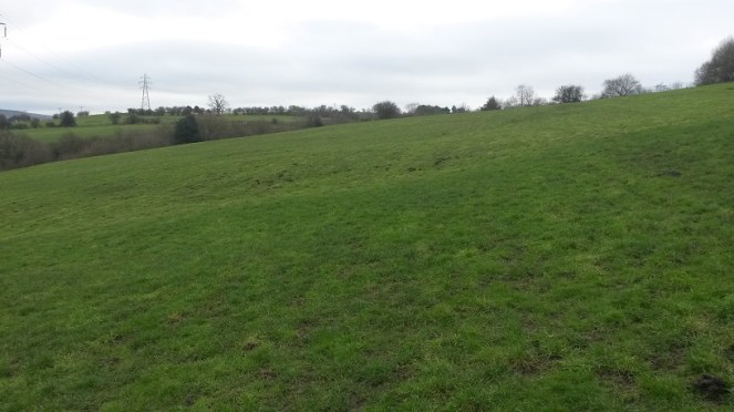
Alas, there is nothing left of Grave Well except a muddy patch in the field.
The muddy area in the middle ground, in the slight dip, corresponds to the location of Grave Well. The ground was boggy and is clearly a spring of some sort. The view is looking south.
I am not sure what would have stood here originally – perhaps a structure like that at Daniel Well, but I feel this is unlikely: it is in the middle of the field, and with only a minor footpath to get to the well. No, I think it more likely that it was a simple affair that held some water where it bubbled from the spring underneath. I love the name, though – obviously derived from its proximity to the burial ground of the church, out of view to the right in the photograph. Either that, or it may recall the discovery of a burial in the immediate area. Either way, it does raise interesting questions about water tables and burials, though, and I’m not sure I would like to drink from Grave Well! Its last mention before it disappears into the veil of history is on the 1882 1:10,000 OS map. It clearly lost its importance, and was gradually forgotten about.
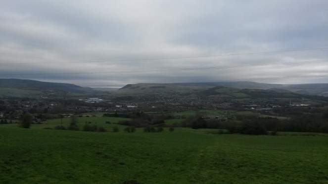
Pushing further on I looked for the Boulder Well and, when I found it, was similarly a little disappointed… at least at first, anyway. It was another muddy patch.
The muddy patch in the left foreground corresponds to the location of Boulder Well on the map. The view from here, looking east, is incredible – Longdendale Valley at the left, Glossopdale at the right, and the hump of Mouselow just right of centre. Melandra is somewhere dead centre of the photograph. Despite it being dark, I am quite proud of this photograph.
As with Grave Well, I am not sure what would have stood here originally – probably nothing much. Also, in common with Grave Well, the last mention of it on the OS map is the 1882 1:10,000 map, after which it disappears, and is gone forever. The name intrigued me, though: Boulder Well is a very specific name, deriving from… well, one assumes… a boulder. The lack of boulder is, then, confusing, and a little disappointing.
I pushed on regardless, to see what I could see. And lo! In the next field north, at the edge, there stood a bloody big boulder!
The boulder! Looking north. It is marked as point ‘1’ on the satellite map above.Close up of the boulder. It is a glacial erratic of some sort, rounded and left behind by the retreating ice.
Now, although it is in a different field, this must be the origin of the name Boulder Well. Indeed, it appears to have been moved ‘recently’ – it is sitting on top of the grass, rather than embedded in it. However, if it had been moved, this at least would explain why it is in a different field from the ‘well’, and why it now stands comfortably out of the way at the field boundary. I wonder when it was moved, and where it stood originally.
The boulder, with the Longdendale Valley behind it.
The fate of these wells is interesting, and is obviously tied to the introduction of clean piped drinking water directly into your home. We – and I am very guilty of this – have a tendency to romanticise the past, and a wish to remove the trappings of modern day living, to peel back all the ‘progress’ we have made, and to revert to a simpler way of life. I love the idea of having to walk to a well to draw pure cold water, it would be so… earthy, grounding, basic. Free and simple.
But then I have never done it in the rain, sleet, or snow, wearing ill fitting wooden clogs, wrapped in a basic cloth shirt, slipping down a muddy unmetalled path, after having worked 15 hours in a mill.
I may yearn for a less commercial, more simple life… but I don’t yearn for pneumonia.
Hope you enjoyed the jaunt around Mottram. I have a few more posts I’d like to do about various wells – they intrigue me – so watch this space.
There is still lots to do, and lots more to find – but I saw this the other day, up on Cliffe Road, on the exterior wall of a garden.
T & J captured forever! I like to imagine a married couple (Tommy and Jane?) still together but now in their nineties, and who still feel a pang of guilt every time they walk past this wall.
Who ‘T & J’ were, we may never know, but the stone has been re-used from elsewhere to build the wall – which means someone saw the graffiti and thought to keep it right side up and readable, which I think is nice.
Now, more seriously. I mentioned the book, Medieval Church Graffiti, in the last graffiti post (here). It is a really interesting read, and has resonance in the work I do at the Blackden Trust (link here), so I can’t recommend it highly enough. However, the rather incredible folk at Tameside Archaeological Society (website here) have begun their own project at Mottram St Michael and All Angels, looking at the graffiti there… and coming up spades (pun fully intended). Their brief report is here, but let’s hope for more soon. Actually, in a way, I’m annoyed, as as soon as I read the book, I thought “I know, Mottram church, that’ll have some graffiti, and I’ll be able to post it on the blog…”. But I have been beaten to the punch.
However… If anyone fancies spending an afternoon or two in Glossop’s All Saints Church looking for graffiti, give me an email. Although the building as it stands dates largely from 1831 onwards, it replaced the medieval church, and reused some stone in the rebuilding process, particularly in the nave. There may be something left behind… perhaps. Anyway, drop me a line – but at least glance at the book first (here).
The next post (Thursday… probably) will be based around Mottram church, so keep your eyes open. Oh, and more pottery is incoming.