With nothing open, the roads all but impassable, and with the wind roaring outside, it gives me the perfect excuse to open a bottle of wine, light the fire, and blog some more.
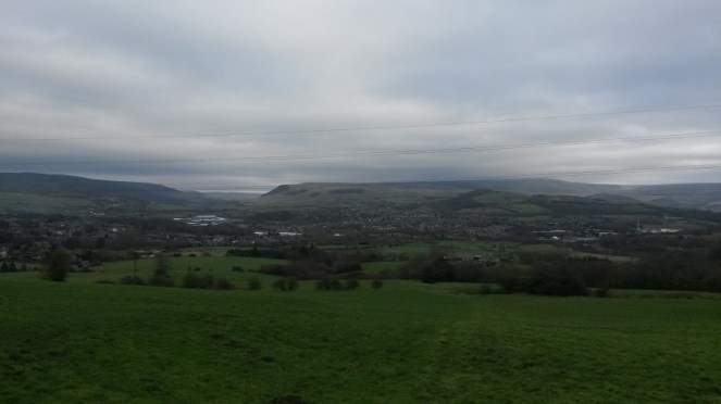
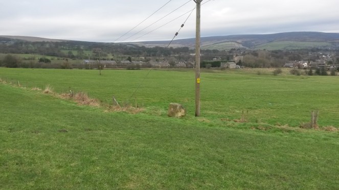
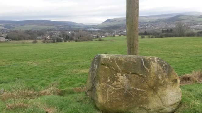
A few weeks ago I went for a walk up the hill and along the path that runs past Whitfield Cross. In the field before the cross, there was what can only be described as an infestation of moles. A big infestation… it looked like it had been bombed!
In the past I have found some very interesting things in molehills – a mesolithic flint flake, a WWI German 7.92mm bullet (in Belgium), and a sherd of 2nd century Roman pottery. I also know of a molehill that produced an Iron Age stater coin (sadly, not mine). So, I never pass a molehill without having a look.
I have to say, this haul was sadly not as impressive as that, but I’m using it to illustrate an interesting historical process, as well as an archaeological phenomenon. But first the haul.
Gifts from the moles!
Top left is a rim from a cup or similar open small vessel. Top middle is a from a glass vessel – it is a rim of some form, but is shaped in an odd way, so I think that it comes from the spout of a glass jug. Top right is a brick… plain and simple. Bottom left is a Bakelite comb fragment – the maker’s name is ‘Tudor Rose’, who, as far as I can tell, still make combs. And finally, bottom right is some cinder – essentially what is left after coal has been burned.
So not at all impressive, or even that interesting. The interesting bit lies in the question “how did it get there?”.
Any ploughed field you see, anywhere in Britain, will have a huge amount of pottery and glass lying within the ploughsoil. You can even see it at a distance, glistening in the sunlight. And most fields will have been ploughed at some stage in their history, even if they are pasture land now. So how do these items end up in the ground? There are no brick structures nearby, nor are there any coal fires. It’s an odd place for someone to comb their hair, and even odder for them to serve drinks from a glass jug into a china teacup. If these were found next to a house, the solution would be simple – they are rubbish chucked over the back fence. But this is a middle of a field in the middle of nowhere, and nobody walks into a field to dispose of rubbish.
The solution is night soil. A lovely Victorian euphemism for… well, let’s not beat around the bush. Poo.
In the Victorian and early Edwardian period, and even more recently in certain areas, no one had an inside flushing toilet. One did one’s business into a bucket that was emptied every night by the night soil man, whose job cannot have been a bundle of laughs. Also, as there was no real system for the disposal of domestic waste, if you dropped a plate, you simply chucked it into the bucket, along with glass, coal fire ashes, and anything else that couldn’t be mended or recycled. The night soil man would then come along, remove the bucket and contents, and take it away.
The larger fragments of pottery, etc. would be removed, but no one wants to spend too long picking tiny pieces of pottery out of the waste. What was left over, including the smaller pieces of pottery, etc., would be sold to farmers as fertiliser, and who then spread it onto their fields. A wonderful system of literally wasting nothing, and one that some environmentalists are promoting – better than using artificial fertilisers, apparently. Over time, a huge amount of pottery and other bits would have been ploughed into the soil, which is why so much of it is still visible.
So there you go, the story of how these random bits ended up in a field – the mole simply turned over a night soil fertilised field. I am assuming they originated in Glossop – the town was very densely populated, and there was very little by way of sanitation in the Victorian period. Most houses, being terraced, would have had a shared privy – we have our row’s privy in our garden and it is now used as a shed! But it once served 6 houses, with at least 5 people in each house by the late Victorian period – that’s a lot of night soil!
There is a place in Upholland, Lancashire, next to the canal, where barges full of night soil from Liverpool would be unloaded and spread onto a huge cobbled area there and roughly sorted. It is right next to a pub whose name escapes me, pleasant and rural now, but 130 years ago would have been very different!
Anyway, the moral of the story is always check out molehills (and also any ploughed field), as you never know what might turn up. And don’t worry, 100+ years is a long time for night soil to linger… just don’t think about it, and wash your hands afterwards, just in case!
I thought I’d venture a little farther afield this week. The blog is intended to explore Glossop’s heritage, but I feel that if I can see it from Glossop, I should be allowed to blog about it… even if it is in another county.
But don’t worry, we won’t be going to Yorkshire!
St Michael and All Angels church in Mottram dominates this end of Longdendale – it is visible from all sorts of angles, disappearing as you travel various roads and paths, only to pop up unexpectedly from behind buildings or between trees. Indeed, it’s presence keeps watch over the valley, almost as a reminder that the church watches over the people. In fact, I can see it from James’ window, on the distant brow.
St Michael and All Angels, Mottram. Photograph by Stephen Burton.
It sits on a prominence called War Hill (from the Middle English Quarrelle, meaning quarry), and is a particularly bleak place, catching all the wind that roars down Longdendale from the moors. The church itself, though severely ‘improved’ during the Victorian period (read, monkeyed around with and partly rebuilt) is still at its heart essentially late medieval in date – mid 15th Century or so. Going further back, it may well have been the site of Saxon church prior to that. Travelling even further, there is evidence in the form of cropmarks that it might have been the site of a Roman signal station connected to Melandra – a perfect place with commanding views up and down Longdendale. Prior even to that, particularly given its prominent location in the landscape, it must surely have been attractive in prehistory, though there is no evidence at present.
As an interesting aside, during the late 17th Century a whole pile of my ancestors, the Williamsons, were ‘hatched, matched, and dispatched’ here (that is, they were baptised, married and buried). The Williamson family married into the Sidebottom family who were fairly big in this area, were important in the early Industrial period, and were consequently quite wealthy. Alas, my line gradually becomes poorer, and we end up in East Manchester working in a mill, rather than owning it.
Signature of John Williamson, my great, great. great, great, great, great, great grandfather, born in 1678 in Mottram, and who married Elizabeth Sidebottom on 15th February 1703 in Mottram Church… exactly 315 years to the day, today, coincidentally, and rather spookily. I will raise a glass to them whilst looking at the church as soon as I have published this post!
Perusing the old OS maps of the area, as I am wont to do (here), I noticed three wells in the immediate vicinity. Now, nothing unusual there, the whole area is teeming with them as we live in an area with a high number of springs. However, what was unusual is that all three, very close together, were named. Normally, a well is simply marked ‘well‘ on an OS map, but the fact that these have names could indicate that there may be more to them. And what names they are – Daniel Well, Grave Well, and Boulder Well – names that conjured up wonderful images. Well, well, well, I thought, this must be worth an investigation.
The three wells, Daniel, Grave, and Boulder, are outlined in Red. Mottram church is outlined in green in order to get your bearings. This is from the 1886 1:2500 OS map. Note also the Coal Shaft and Mottram Colliery marked – the area has a very low quality coal seam running through it that was sporadically mined in the 18th and 19th centuries.
And so it was.
Daniel Well is situated on the left, northern, side of a track that comes from War Hill along the side of the school, and downhill to a pond. Interestingly, the only artefactual evidence from this exploration came from this first part of the track, just behind the school playground.
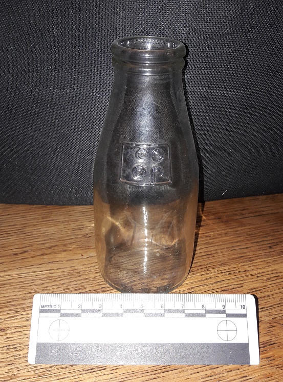
1/3 pint of Co-Op school milk in a squat bottle. This really is a nostalgic trip!
I am just about old enough to remember free school milk, and these are the bottles they came in… It has been over 30 years since I touched one of these last, and the feeling was one of immediate nostalgia and a weird sense of happiness. Silver foil top and a blue plastic straw… I was back in Bradshaw Hall Infants School, just like it was yesterday! What I love about this artefact is that the only way it could have ended up on the track behind the playground is if some naughty child threw it over the fence… if you put it to your ear, I swear I can hear the “vip, vip, vip” sound of Parka coats rubbing together and the cries of “go on, I dare you… chuck it!”.
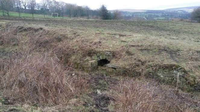
On to Daniel Well, then. The sunken path is muddy, but well constructed and was clearly used – I wondered if this was the main well for the area. My first sight of it seems to confirm that thought.
Daniel Well, overgrown and unloved. Beyond is the playing field of Mottram School, and beyond that, Longdendale.
The path widens out at this point, and the stone built well head structure stands well built still. The path is very boggy, and although the well is overgrown and possibly relatively dry in terms of water within it, the spring that created the well is still flowing freely downhill.
Close up of Daniel Well. Stone built arch, and side platforms upon which to put your buckets, bottles, etc.
The stone-built arch that is the front of the well goes back some three feet, although it is sadly now full of collapsed rubble. To me, this seems a sad end to what was one of the most vital aspects of the village – lives were, quite literally, saved with this water. Food, drink, laundry, baths, all came from this point. People who met drawing water here married in the church above, and had children. Gossip and community, focused on this place, and yet, no longer. I would love to see it restored, or just a little better cared for.
Following the path down, the water flows into this secluded and sheltered pond.
The pond from the end of the track. The water flowing into it from behind the camera comes from Daniel Well. It then flow out again through a channel to the left.
Clearly Daniel Well was an important well in the area – the path and the stone built well head attest to this. I have no idea about the name, though – possibly from a personal name of the person who owned the land? Something Biblical, maybe? Any thoughts, anyone? The 1954 1:10,00 sees the last mention of Daniel Well on an OS map, and clearly by that point it had ceased to be important as a water source. Sadly, I doubt anyone living nearby would know it was there now, or at least know that it had a name.
Making my way back up, I decided to look for the other two wells. I had studied Google maps before exploring, and took a while to work out the locations by superimposing the old map field boundaries onto the modern satellite image of the area.
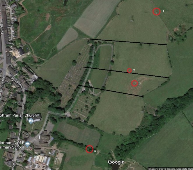
4 is Daniel Well, 3 is Grave Well, and 2 is Boulder Well. 1 becomes important in the discussion below. The black lines are the field boundaries shown in the 1886 map that are no longer there to help with orientation.
Alas, there is nothing left of Grave Well except a muddy patch in the field.
The muddy area in the middle ground, in the slight dip, corresponds to the location of Grave Well. The ground was boggy and is clearly a spring of some sort. The view is looking south.
I am not sure what would have stood here originally – perhaps a structure like that at Daniel Well, but I feel this is unlikely: it is in the middle of the field, and with only a minor footpath to get to the well. No, I think it more likely that it was a simple affair that held some water where it bubbled from the spring underneath. I love the name, though – obviously derived from its proximity to the burial ground of the church, out of view to the right in the photograph. Either that, or it may recall the discovery of a burial in the immediate area. Either way, it does raise interesting questions about water tables and burials, though, and I’m not sure I would like to drink from Grave Well! Its last mention before it disappears into the veil of history is on the 1882 1:10,000 OS map. It clearly lost its importance, and was gradually forgotten about.
Pushing further on I looked for the Boulder Well and, when I found it, was similarly a little disappointed… at least at first, anyway. It was another muddy patch.
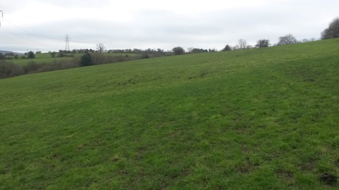
The muddy patch in the left foreground corresponds to the location of Boulder Well on the map. The view from here, looking east, is incredible – Longdendale Valley at the left, Glossopdale at the right, and the hump of Mouselow just right of centre. Melandra is somewhere dead centre of the photograph. Despite it being dark, I am quite proud of this photograph.
As with Grave Well, I am not sure what would have stood here originally – probably nothing much. Also, in common with Grave Well, the last mention of it on the OS map is the 1882 1:10,000 map, after which it disappears, and is gone forever. The name intrigued me, though: Boulder Well is a very specific name, deriving from… well, one assumes… a boulder. The lack of boulder is, then, confusing, and a little disappointing.
I pushed on regardless, to see what I could see. And lo! In the next field north, at the edge, there stood a bloody big boulder!
The boulder! Looking north. It is marked as point ‘1’ on the satellite map above.Close up of the boulder. It is a glacial erratic of some sort, rounded and left behind by the retreating ice.
Now, although it is in a different field, this must be the origin of the name Boulder Well. Indeed, it appears to have been moved ‘recently’ – it is sitting on top of the grass, rather than embedded in it. However, if it had been moved, this at least would explain why it is in a different field from the ‘well’, and why it now stands comfortably out of the way at the field boundary. I wonder when it was moved, and where it stood originally.
The boulder, with the Longdendale Valley behind it.
The fate of these wells is interesting, and is obviously tied to the introduction of clean piped drinking water directly into your home. We – and I am very guilty of this – have a tendency to romanticise the past, and a wish to remove the trappings of modern day living, to peel back all the ‘progress’ we have made, and to revert to a simpler way of life. I love the idea of having to walk to a well to draw pure cold water, it would be so… earthy, grounding, basic. Free and simple.
But then I have never done it in the rain, sleet, or snow, wearing ill fitting wooden clogs, wrapped in a basic cloth shirt, slipping down a muddy unmetalled path, after having worked 15 hours in a mill.
I may yearn for a less commercial, more simple life… but I don’t yearn for pneumonia.
Hope you enjoyed the jaunt around Mottram. I have a few more posts I’d like to do about various wells – they intrigue me – so watch this space.
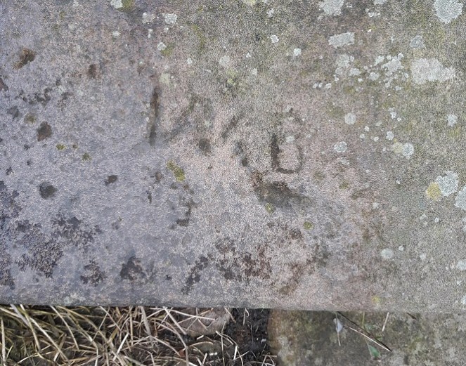
There is still lots to do, and lots more to find – but I saw this the other day, up on Cliffe Road, on the exterior wall of a garden.
T & J captured forever! I like to imagine a married couple (Tommy and Jane?) still together but now in their nineties, and who still feel a pang of guilt every time they walk past this wall.
Who ‘T & J’ were, we may never know, but the stone has been re-used from elsewhere to build the wall – which means someone saw the graffiti and thought to keep it right side up and readable, which I think is nice.
Now, more seriously. I mentioned the book, Medieval Church Graffiti, in the last graffiti post (here). It is a really interesting read, and has resonance in the work I do at the Blackden Trust (link here), so I can’t recommend it highly enough. However, the rather incredible folk at Tameside Archaeological Society (website here) have begun their own project at Mottram St Michael and All Angels, looking at the graffiti there… and coming up spades (pun fully intended). Their brief report is here, but let’s hope for more soon. Actually, in a way, I’m annoyed, as as soon as I read the book, I thought “I know, Mottram church, that’ll have some graffiti, and I’ll be able to post it on the blog…”. But I have been beaten to the punch.
However… If anyone fancies spending an afternoon or two in Glossop’s All Saints Church looking for graffiti, give me an email. Although the building as it stands dates largely from 1831 onwards, it replaced the medieval church, and reused some stone in the rebuilding process, particularly in the nave. There may be something left behind… perhaps. Anyway, drop me a line – but at least glance at the book first (here).
The next post (Thursday… probably) will be based around Mottram church, so keep your eyes open. Oh, and more pottery is incoming.
Well, so far I have managed to fail utterly in my New Year’s resolution in posting at least once a week. So my apologies. A lot of my spare time has recently been taken up with writing and preparing for a talk I am going to give on the subject of Whitfield Cross. Interestingly, the Whitfield Cross post (here) is by far and away the most popular on this blog. I know this because behind the scenes here, there are a whole pile of statistics that can be accessed that tells me how many people visit each day, what they look at, and even from where they come – yesterday, for example, I even had a visitor from South Africa! Now, I have no idea why the Whitfield Cross post is so popular, but when I was asked to give a talk on any subject, I though I’d go with that!
The talk is titled: Whitfield Cross – Glossop’s Saxon Heritage
To be given to the excellent folk of the Glossop and Longdendale Archaeological Society (website here) on Tuesday 3rd April at the Bluebell Wood pub, Glossop Road, Gamesley. Talk starts at 7.30, so get there a little earlier, and it’ll cost £2 on the door (although for £5, you can join GLAS and reap the benefits for the year).
The talk will draw on the blog post, but will include new research into Glossop’s only Anglo Saxon feature, and include a discussion of other examples of Mercian Round Shafts.
Plus, this is your chance to find out who Robert Hamnett actually is… and buy him (well, me) a drink!
In all seriousness though, come along – if you are interested in the blog, or Whitfield Cross, you’ll be interested in this.
Right, despite having another cold (courtesy of the ever ill James), I shall try and bash out another blog entry
The urge to leave a mark in the landscape – a part of you or a reminder that you were there, once, even long after you are gone – is undoubtedly a universal feeling, and one that has been with us since we humans first started ‘thinking’. The cave art seen in places like Lascaux and others are believed to be ritual and ‘Shamanic‘ in nature, as well as displaying entoptic traits, probably drawn under the influence of hallucinogenic substances, and again ritual in origin. However, I am also convinced that some of them are the Upper Palaeolithic equivalent of “Kilroy Woz ‘Ere”.
Graffiti can be an eyesore – scrawls and rude words for example. But it can also be rather beautiful; there is some amazing ‘street art’ out there, done by people with phenomenal talent. However, it must be stated that even the rude word variety has an impressive heritage – the Romans were famous for it! Even medieval churches were not immune to it – if eternal hellfire and damnation isn’t deterrent enough, an asbo certainly won’t cut the mustard.
But it is the humble name that is most often written; a cry in the wilderness of life, and wish to be remembered, to have left a mark, however small, so that some part of you is immortal. Now, I’m not about to post a bunch of photographs of random spraypainted words… no, no, no! This graffiti has some age to it.
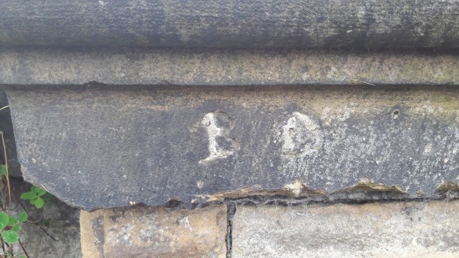
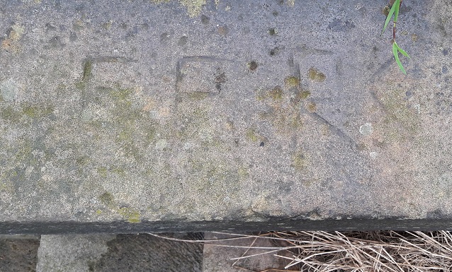
Nowadays, any moron can (and frequently does) use spraypaint, marker pen, emulsion, or any one a number of other ways to leave their mark. However, back in the Victorian period, if you wanted to write your name, you really had to mean it! Armed with a hammer and a heavy duty chisel, and a good few minutes whilst you etched your initials permanently into stone. It is surprisingly common to come across this sort of thing, but recently I have been photographing the ones I see in Glossop. I have more photographs somewhere, but for now, may I present ‘Gone, But No Longer Forgotten’.
This is on Bank Street – my favourite path. Slightly haphazard initials – T.A. – carved into a stone that is oddly coloured. There are no other similarly coloured stones around it, and it looks like it has been burnt at some point before being used in this wall.This one is from Whitfield Recreational Ground, the Wood Street side. ‘B.D.’ carved into a capstone. It also looks like it has been filled in at some stage. Given that the park was opened properly in 1902, we have a firm date after which it must have been carved. It’s also nice to see the marks of the chisel that dressed the stone – all representing one person’s labour spent in shaping it.Whitfield Recreation Ground once again, this time the Wood Street stairs. ‘W.B.’ very messily carved – standards clearly slipping. There is possibly a ‘J’ carved below the W.This one is also on the Wood Street stairs. ‘F.F.R.C’? Unclear, and I think this is more modern than the others – there has been no attempt to carve the curves of each letter, and instead an unskilled hand has block carved the initials. Shocking!
As I say, I do have more somewhere, and I’ll post them when I find them. In the meantime, if anyone knows of any more, let me know. I have some on my garden wall that are particularly interesting, but I’m saving them for their own post.
Next blog post will involve pottery… probably.
Or Victoria Bridge.
Anyway, Happy New Year to you all, and as always, comments are welcome… especially if you know the identity of any of these miscreants!
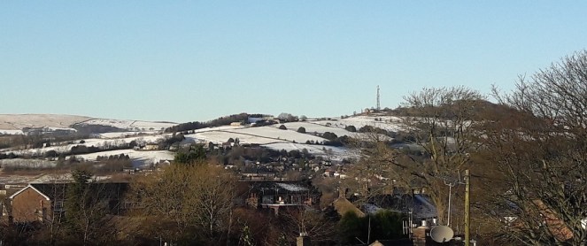
Wishing you all a very Merry Christmas, and here’s to a new Year filled with history and archaeology. To celebrate, enjoy a seasonal photograph of Mouselow taken from the SSE a few days ago.
Mouselow from the South South East. A closeup of the important bits. Apologies for rather poor photoograph… I really do need to invest in a decent camera.
Mouselow is an Iron Age hillfort, and a scheduled monument. It is also a hugely important part of Glossop’s history, and one that deserves a long post all to itself. This is just bit of Christmas fun.
In the photograph then. Just below and to the left of the antenna, you can see medieval ridge and furrow, a characteristic field mark derived from ploughing, highlighted in the snow. The snow, blowing in from one direction, sticks to one side of the ridge only, creating the stripes.
Also, just below that, it is possible to make out one of the massive ditches that would have surrounded the hillfort. Whether for defence, or for ritual reasons, to make the hill separate from the surrounding land, we don’t know. However, and whichever, Mouselow dominates the Glossop skyline.
A short, place-holder, blog entry today. Real life is preventing me from posting as often as I would like, but I have a series of shorter posts to keep it ticking along whilst I work on a larger post. James is finally asleep, which means I get a cup of tea and some time to write this up… hastily. There’s washing up, laundry, and tidying to be done: being a 21st century househusband is not easy, and I raise my (Homburg) hat to my mother who made it all look so effortless.
So, in keeping with the post of the junction of two brooks here, I thought I’d do something similar.
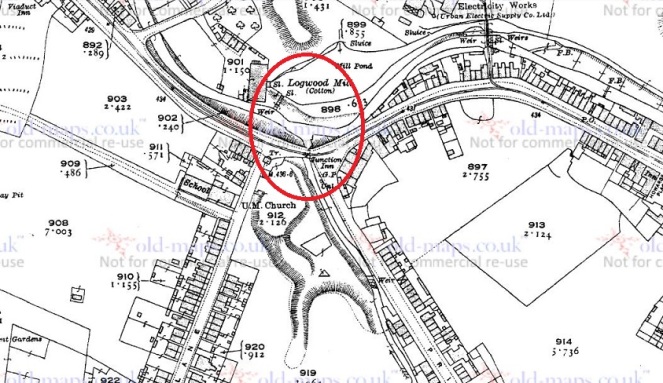
Long Clough Brook starts in the valley to the west of the Grouse inn (now a house) in Chunal, and wends its way down along the valley, taking in streams and brooks as it goes. Of these, the most notable is Bray Clough Brook, which it joins at Charlestown. This is important, because at that point it becomes the boundary between Whitfield Parish (eastern bank) and Simmondley (western bank).
From Turnlee, it weaves in and out of Primrose Lane, and plays merry havoc with the boundaries – for example, the upper part of Slatelands Road is Whitfield, the lower part in Simmondley. And so it goes all the way down to the roundabout at the junction of Primrose Lane and Dinting Vale/High Street West, where the Junction Pub (now offices) stands.
The confluence of Long Clough Brook (from the south) & Glossop Brook (running east-west at the top) is circled in red. High Street West is on the right, Primrose Lane and Simmondley Lane exit south out of the map. This is from the 1921 1:2500 OS map.
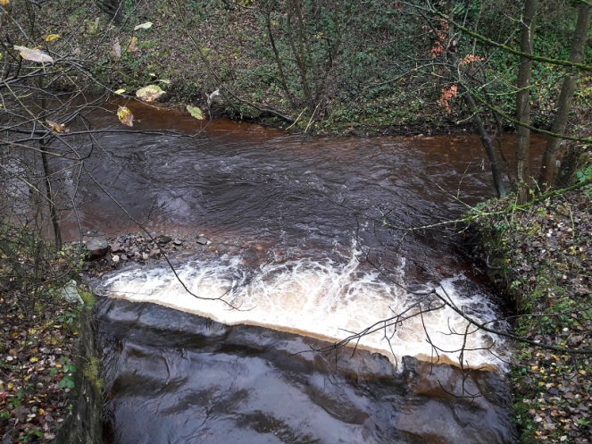
Here, on the other side of the road, it gushes out into Glossop Brook.
Glossop Brook, running east-west, is joined by Long Clough Brook from the south.
What is interesting about this is that the boundaries of three of the ‘villages’ that make up Glossop – Whitfield, Glossop, and Simmondley – are defined by this particular junction. In the photographs above, then, the land on the left is Simmondley, on the right is Whitfield, and the land beyond is Glossop. Oh, and the whole area is Dinting Vale, technically, just to add to the confusion.
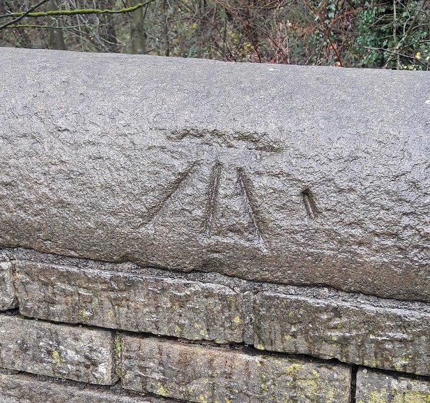
And of course, it wouldn’t be a post by me without a Bench Mark! This one on the wall just to the east of the confluence.
A mystery Bench Mark. Alright, so it’s not that mysterious.
Except, bizarrely, I can’t find it on the map. The only Bench Mark noted is on the old Junction Inn at 433.42ft above sea level, which annoyingly I forgot to photograph. This, is not to be found anywhere. It is also subtly different from the usual mark – the arrow doesn’t join the level, and there is another, probably associated, mark carved to the right. Nope, a bit of a mystery!
It is my intention to do a proper post on each of the brooks in the area eventually, detailing all the tributaries and confluences – a summer project I think, but stick around.
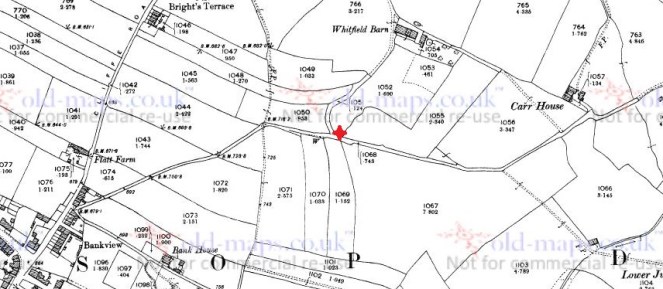
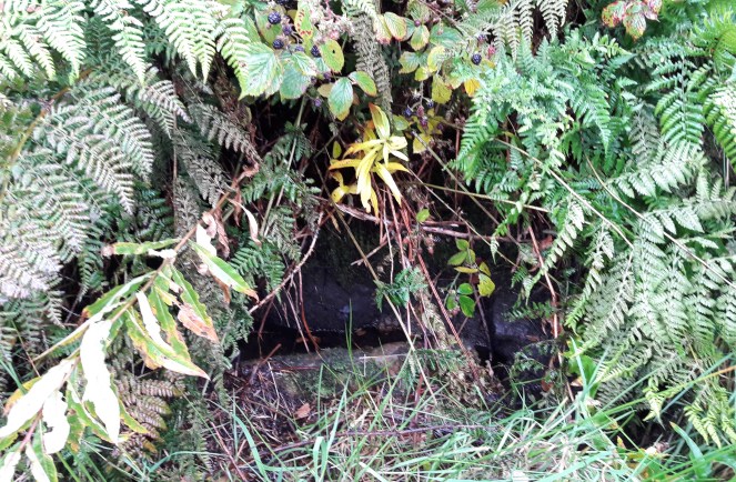
With all the talk of Carr House Lane and the guide stoop there (or lack thereof) the Whitfield Cross post generated (see comments here), I thought I’d go back and walk down Carr House Lane and do a post about the ‘Stone Cross’ there. Incidentally, I have a post about Carr House Lane archaeology that I will get to after this (lots of lovely Victorian pottery), but I want to concentrate on the ‘cross’ for now. The stone is situated here:
For orientation, bottom left is the top end of Whitfield Cross where it joins Cliffe Road. the red cross marks the… well, cross. Or whatever it is.
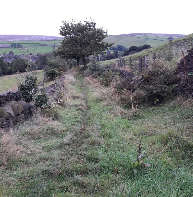
The sunken road from Cliffe Road becomes increasingly boggy the further you go down, not helped, after you turn east, by the stone built spring fed well on the right (marked ‘W’ on the map). This is entirely appropriate – the word ‘Carr’ is derived from the Old Norse ‘Kjarr’ meaning a low lying boggy area… they’re not kidding.
A terrible photograph of the stone trough of the well on the south side of Carr House Lane. I must wait for winter for better photographs.
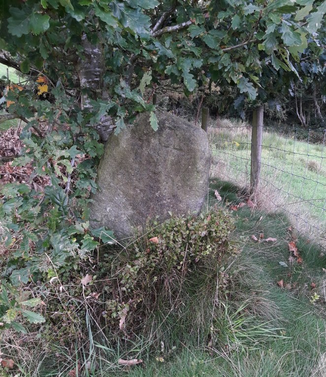
The stone, when you come upon it, is very easily seen, despite being tucked away and in the shelter of an oak tree.
Nestled in an Oak tree, the stone sits at a jaunty angle on the left hand side as you come down the track from the Whitfield end.
What is immediately obvious, more so on the ground than on the map, is that the stone marks the point where a track branches from Carr House Lane down to Whitfield Barn. Whitfield Barn is at least 18th Century in date, and probably earlier in origin, though without closer inspection is impossible to tell. The main track continues down to Carr House, a farm building of similar date, and which lends its name to the pathway.
This is significant, as it is exactly the sort of place one would expect to find a cross, marking a track junction (see here and here, and the comments for both, for discussion).
The track down from the Whitfield end of Carr House Lane.Carr House Lane as it continues down from Whitfield to Carr House itself.The branch that comes off Carr House Lane down to Whitfield Barn. The cross lies just out of shot to the right.
And yet it is not a true cross, not in the general sense anyway – it is simply a stone with a cross carved into it. I think it likely that the stone was there long before the the cross, and that it was originally a waymarker making sure the track down to Whitfield Barn wasn’t lost, particularly in the dark.
Now, it is just possible that it is a standing stone, by which I mean a prehistoric standing stone – there are several in the area. However, this interpretation is problematic. Firstly, a prehistoric standing stone is just that… a standing stone, erected in prehistory. However, a standing stone erected yesterday will look exactly the same. Thus, without any associated datable features (a barrow, a stone circle, a burial), we cannot state that the stone is prehistoric. Could be, but might not be. Secondly, its situation, at the junction of the tracks, suggests a connection with, and thus a product of and post-dating, them. It could be argued that the tracks are situated to take into account an already existing stone – that is, the track to Whitfield Barn could have been made anywhere along Carr House Lane, but it made sense to split it at the stone – but again that is impossible to prove.
What I will say is that the stone certainly isn’t a disused gatepost, nor is it naturally occurring in that upright position. Which means it has been placed, with purpose and meaning, by someone. Neville Sharpe, in his book ‘Crosses of the Peak District‘, states that it has been shaped, which is certainly the case, so it seems some thought and care has gone into what it looks like.
The cross carved into it is interesting, also. It has been suggested that some roadside crosses were placed as a gift of thanks for the completion of a safe journey, effectively a votive offering in payment for an answered prayer (i.e. help me get home in this awful weather, and I’ll set up a cross to say thank you). They might also function as a spiritual fortifier, reminding the traveller of God’s watchful eye and protective power over the faithful. It is easy, in these days of surfaced roads, street lights, and large settlements, to forget just how dark and treacherous travelling in the pre-modern era would have been – making your way from A to B in total darkness, along a muddy track, and with no map as such, and knowing that if you took a wrong turn somewhere, you were lost. And I find it difficult enough to find the bathroom at night!
That stated, there is something about the cross that suggests to me that it seems to have been more of an afterthought – the result of a sudden onset of piety perhaps, long after the stone was set in place.
Close up of the carved cross. I really need to go back and re-photograph it properly.
It is two simple chisel strokes, one vertical, one horizontal, and the job is done. Why go to the effort of raising and bedding a stone that weighs 1/4 tonne, perhaps more, and then just carve a simple cross into it? The cross is not particularly well executed, either – it is certainly not the effort of a stonemason or even someone familiar with stone. Sharpe (p.42) suggests that it was cut “a long time ago” as the cross would have been vertical when carved, and age has slumped the stone. Logically, this is a sound argument, but the fact that there is an Oak tree growing behind it and to the left (i.e. the direction from which it would push the stone) may suggest a more modern date. Whatever the case, I would suggest that the raising of the stone and the carving of the cross are two separate events that probably occurred many years apart.
What I do find intriguing is that the carved cross strongly resembles this mystery carved cross. Well, obviously… it’s a cross, one of the simplest and easiest designs you can carve onto a stone surface. But the cross design, two simple strokes, thin and unfussy, but seemingly not done by a professional, is similar. Moreover, it is something of a coincidence that two seemingly random stones, separated by roughly 700m, both have a very simple cross design carved into them, and probably as an afterthought. I wonder if someone in the area caught a little divine inspiration and went on a carving spree? And I wonder, if we keep our eyes open, will we find any more?
As always, thoughts, comments, and corrections are very welcome.
With an obvious predictability, I cannot resist having a poke around the brook whenever I’m in the neighbourhood – there is always something to find. Ok, so it’s not quite mudlarking on the Thames foreshore, but it is Glossop’s equivalent, and that makes it all the more important to us (if not quite as bountiful!). By the way, if anyone is interested in mudlarking, or the slightly haphazard and magpie approach to the past that this blog is following, then check out the book London in Fragments by Ted Sandling. I cannot recommend it enough – beautifully illustrated with fragments of pot, glass, pipe, stone, metal, etc. and each with a very interesting essay accompanying the item (be warned, the ‘Look Inside’ feature on Amazon misses out allof the photographs!). Just beautiful.
So then, the haul!
At first glance, not that inspiring… but bear with me!
As is becoming my habit, unless they were decorated, or a rim, a base, or a handle, I left the white glazed earthernware and china in the brook. As a rule of thumb, these are the four criteria archaeologists use to sort out the ‘feature sherds’, which are diagnostic (giving us information about date, type, function, etc.) from the ‘body sherds’, which normally make up the majority of a assemblage. It is a rule of thumb, though, and some body sherds can be equally important if they are of an unusual fabric, or are able tell us more information.
So what can we see?
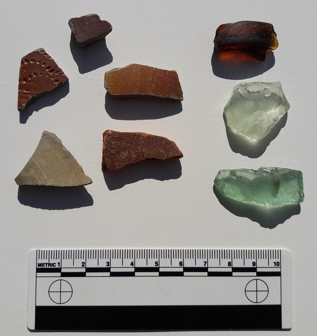
Pottery first. Top sherd is a from a small-ish and closed salt-glazed stoneware vessel. We can tell it is from a closed vessel (i.e. like a bottle, not open like a bowl), by the fact that the interior surface is rougher and unfinished – why waste your time glazing it properly if no one is going to see it? Also, the salt glazing process involves literally throwing salt into the high temperature kiln where it vapourises forming the characteristic glaze; this vapour will not readily reach the interior of the vessel. This vessel was probably something like an ink pot or similar, but by the late 19th century, the date of this sherd, salt-glazed stoneware was mass produced on a literal industrial scale, so it is difficult to be certain.
Middle right. Another closed salt-glazed stoneware vessel, same date, but larger – possibly a milk or lemonade bottle bottle or similar. This sherd is thickening slightly at the left, and so is perhaps forming the shoulder of the bottle.
Middle left, is another salt-glazed stoneware vessel. This one appears to be open, and is decorated by using the rouletting method – a small wheel with teeth was run over the surface to produce the characteristic incised decoration. This one has a very common motif of undulating lines around the body of the pot. The sherd is mid to late 19th century, and probably from a storage jar or crock, and despite being relatively thin, is probably from a large vessel.
Bottom left is the base to a milk or lemonade bottle (it is flat, but lifting slightly toward the middle of the base, and you can see the concentric lines that characterise the base of these bottles). Stoneware again, but a more conventional glaze which gives it the characteristic cream colour. Interestingly, when I flipped it over, you can see a manufacturing flaw – the glaze has pooled against the interior wall, and instead of vitrifying uniformly, it has bubbled and produced a very messy surface.
Flawed glaze at the bottom.
However, it won’t be seen because it is a what? “A closed vessel, Mr Hamnett”, chorused everyone – good to see you are paying attention. It also illustrates why it was probably unwise to reuse these bottles – if it contained milk (raw and unpasteurised, of course), there is no way you could hope to get that clean enough, even with a steriliser.
Bottom right. An interesting sherd… honest. It is a slip-glazed earthernware vessel, and to judge from the colour of the fabric (the clay itself) and the colour of the glaze, as well as the way it flakes away, it is probably 18th Century. Of course, I could be wrong… but there is something about that sherd that gives it an early-ish date.
Glass! Top is from a corked beer bottle… probably. Certainly corked, not capped or screw threaded, and almost certainly beer. And likely Victorian, or early Edwardian.
Middle is probably a Victorian mineral water bottle. The glass is thick and has an embossed ‘&’ sign and some other marks visible, which would have been the name of the maker and their logo. Without doing a lot of serious research, it would be very difficult to say who made it, as a lot of companies were called ‘Something & Something‘. That stated, there were so many mineral water companies that the bottles tended not to travel far, so theoretically there can’t be that many in the area, so it might be worth a look.
Bottom is just a bottle fragment, again probably from a mineral water bottle. i include it here because a) it is a blueish colour, and so potentially earlier than the rest, and b) it has two air bubbles trapped in the glass. At first I thought that it might have been hand blown, but no, I think it is just a feature of the manufacture. What is fun, though, is the fact that within those bubbles lies a tiny amount of Victorian air, preserved for eternity. I wonder what the Victorian period smelled like? Actually, on second thoughts…
So, nothing truly award winning, but a little slice of Glossop history nonetheless.
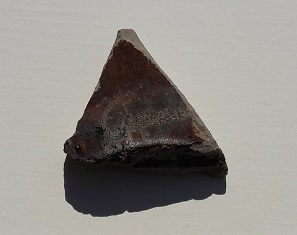
Just as I was about to walk away, I turned over a stone, and found the other side was flat and dressed.
A lump of dressed sandstone!3
It is a sandstone, and not local to the area as far as I can tell, but then I am no geologist. The dressing can be more clearly seen in this photograph, with the low winter sun picking out the chisel marks.
The dressing clearly shown, with a possible mis-hit on the right.
Obviously it was once part of a building, but what part? Maybe a door or window lintel perhaps? I don’t think it is particularly old, and it is quite a coarse dressing, so perhaps it is from a worker’s cottage or similar. The bank in this area seems to have been shored up against erosion, and it probably building demolition rubble dumped here from nearby.
As always, comments are welcome.
I shall post more in a day or so… this time on the subject of Victoria Bridge. Probably!
Before we go any further into this blog entry, let me offer my apologies for the lack of activity here recently. Flu – the real, unpleasant, knocking at death’s door and asking for a priest to administer extreme unction type of flu – followed by the unwelcome intrusion of ‘real life‘ had curtailed my archaeological and historical musings of late. I have done a bit of research, identified a whole pile of fun things to blog about, done some poking about for more interesting sherds… but none of it is quite ready yet.
And so, I present to you, a bit of a cop out! A very short, and quite interesting cop out, but a cop out nonetheless.
As I may have mentioned before, I am obsessed with boundaries.
I love the idea of a start and an end to a physical place or space, and in particular I am fascinated by the ‘liminal‘ areas that make up the join between the two sides of any boundary. These are the ‘dangerous’ places, which are neither one thing nor the other, but somewhere in between, and it this space that has such significance in archaeology. This is where outcasts – the witch, the murderer, the suicide, the excommunicated – are buried, where dangerous activities take place, where the veil separating this world and the other is perceived to be the thinnest, and communication with the ‘beyond’ can be achieved.
One such liminal place is the junction of two rivers or streams, long held to be magical, and in some cultures believed to be a very powerful space.
Waterways themselves make great boundaries – they are by and large immobile, and they are very clear in their separation of the land (one does not overlook a stream, or one ends up with wet feet) – which is why, traditionally, they were used to define parishes and such. Indeed, it has been said that my own parish, Whitfield, is actually an island: it is completely surrounded – and thus defined – by streams.
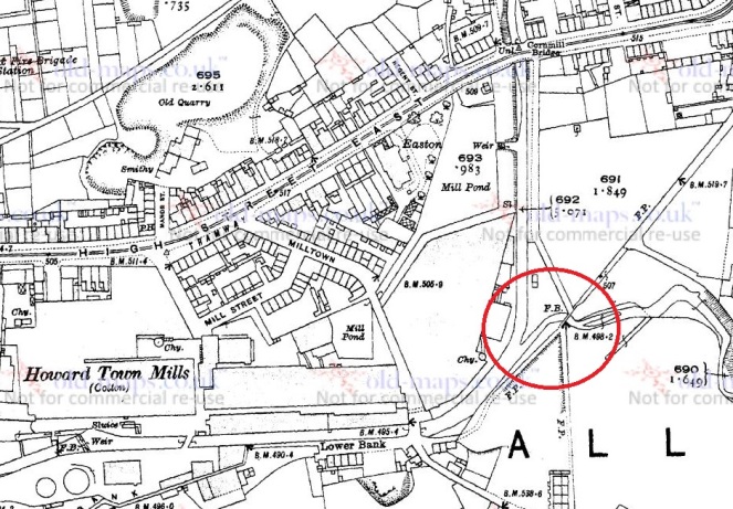
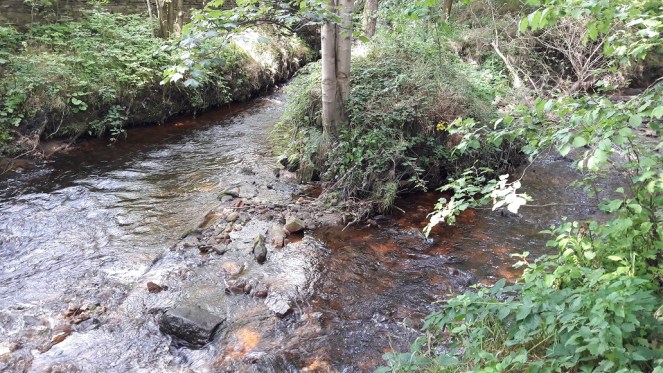
Glossop Brook is the boundary between Whitfield and Glossop, and it is formed by the confluence of two brooks – Shelf Brook, which flows through Manor Park from Mossy Lea and beyond, and Hurst Brook which comes through the Shirebrook Estate from the Snake Pass and beyond. They join here, at the bottom of Bank Street just before the footbridge that takes you to Manor Park
The birth of Glossop Brook. The confluence of Shelf Brook (from the north) and Hurst Brook (from the east) is marked in red. The footbridge (FB) leads to Manor Park (now along Shirebrook Drive). This is from the 1921 1:2500 OS map.
So, a liminal boundary that is formed by the joining of two brooks. Anthropologically, this is a powerful place, and one wonders what, in the deep and distant past, occurred here, or at least what marked this place.
Where the streams meet – Shelf Brook at the top, Hurst Brook at the right… and Glossop Brook exiting left out of the photograph.
This is the first in a series of posts that I’d like to do about Glossop’s waterways. Through their use as power for mills, they are quite literally the foundation upon which the modern town was built, and yet they are sadly often overlooked.
I shall be more attentive to the blog in future, and keep up the posting. Thanks for reading, and if there is anything you’d like to share, any comments or corrections, please drop me a line.