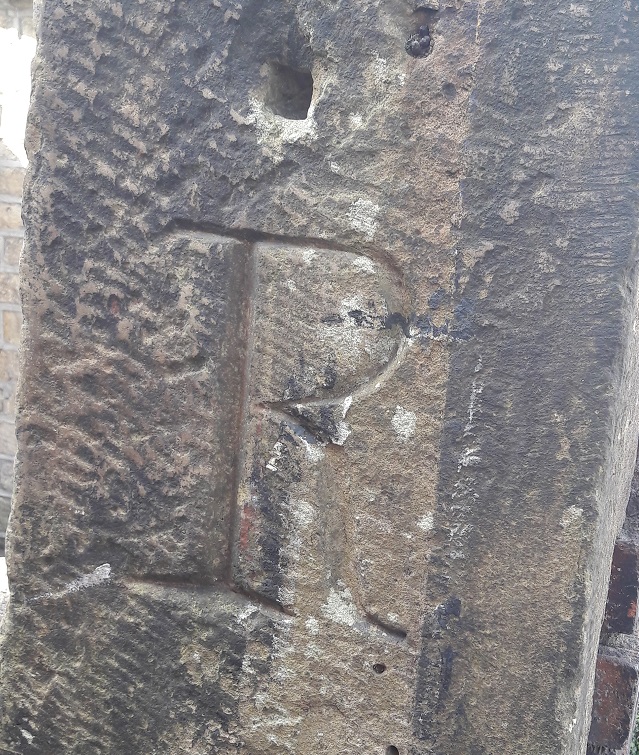
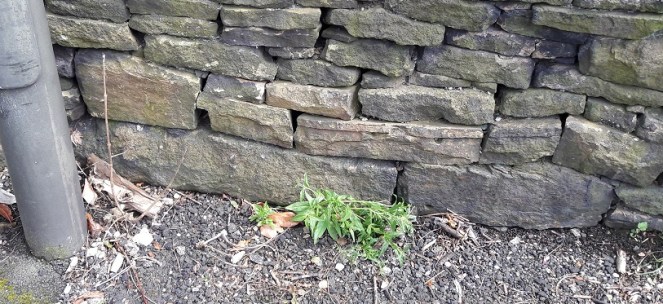
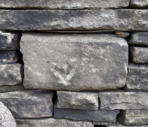
At the bottom of St Mary’s Road, on the left hand side, and just behind the back yard of The Retreat beauty salon, there is a gatepost next to the footpath. It is a fairly standard, if precisely carved, gatepost, and much like many of the others you would find in the area. However, this one has a large upper case letter ‘R’ carved expertly into its face.
The letter ‘R’ beautifully carved.
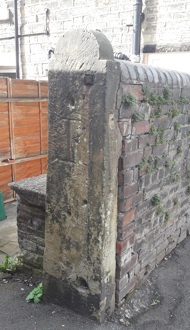
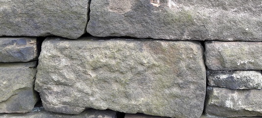
I have no clue why it was carved, nor who did it, nor when. The buildings in this part of Glossop centre are among the oldest (1840’s or thereabouts), and the letter style certainly suggests Victorian origin, and probably early Victorian – the large serifs recalls Georgian lettering. It has clearly been used as a gatepost multiple times, with different gate sizes and shapes, and even paint colours – you can see the evidence in the form of holes and paint. Importantly, most of these were placed over the carving, so post-date it.
Use and re-use – the evidence of the holes, fixings, and paint.
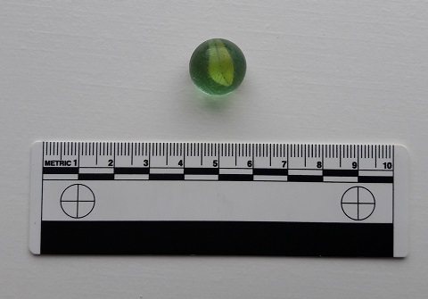
I checked the early maps for any idea, but nothing was shown that may explain its origin. I haven’t had time to check the census records, and these may shed some light on it, but as it stands… no idea! Whilst looking at the post, I found a child’s toy marble in the gutter – not a particularly old one, but it has seen some use, and is covered in scratches and chips. So obviously, I picked it up!
I can’t resist a find, even if it is not quite archaeology.
Any thoughts or suggestions regarding the letter on a postcard please (or you could just, you know, post a comment below).
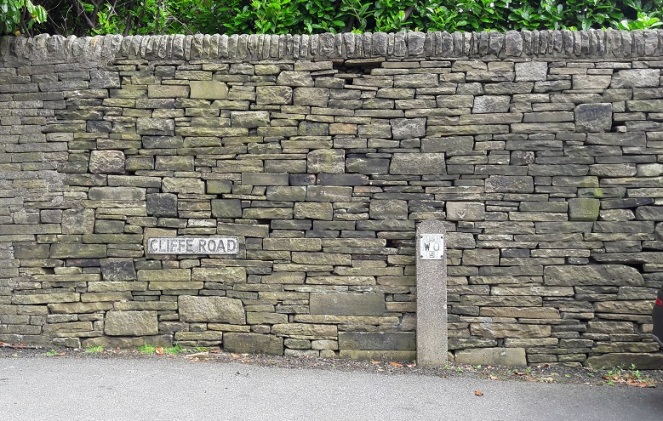
Whitfield Cross. An odd name for a road that doesn’t have a cross on it.
Leading from Gladstone Street up to Hague Street/Cliffe Road, the road takes you past Whitfield Wells, and into the heart of the Whitfield Conservation Area. I lived on King Street for a number of years, and regularly walked up and down the street, without really noticing the name beyond “hmmm, I bet there was cross here at some stage”.
However, whilst delving into the history of the area, I came across an article by the marvellous Robert Hamnett (my namesake) entitled “Botanical Ramble to Moorfield”, dated to about 1890. There is not much botany, but it is a goldmine of local history. You can read the article in PDF form here via the scanned scrapbooks of the New Mills History Society – they have a whole bunch of them to ready to read, all from the late 19th and early 20th century, and all history local to New Mills and surrounding areas, including Glossop. But I digress…
As I read the article my jaw dropped. I repeat the relevant chapter here in full as it is full of great language, some of which might need explaining.
“In the latter part of the last century the Cross Cliffe lads planned and partially carried out what was to them a most daring and audacious deed. One ” Mischief Night,” the eve of the first of May, it was resolved to steal the Whitfield cross. In the depth of night, when all was quiet, and the Whitfield lads were slumbering or dreaming of their “May birch”, the Cross Cliffe invaders came and detached a portion of the cross. With secrecy, care, and much labour, it was conveyed away nearly to its projected destination, but the exertions required for the nefarious deed had been under estimated, their previous work in removing all articles left carelessly in the yards or at the back doors of the good people of Cross Cliffe and neighbourhood, such as clothes lines, props, buckets, etc., etc., to their “May birch” had already taken much of their energy out of them, and, coupled with the steepness of the ascent to the “Top o’ th’ Cross,” distance and roughness of the road to Cross Cliffe, and the weight of the stone, they were reluctantly obliged to abandon their “loot” in the last field near to the pre-arranged destination. What the feelings were of the Whitfield lads on discovering the desecration and loss of a portion of their cross can be better imagined than described. The stolen portion remained in the field for some years. Mr Joseph Hague, of Park Hall, was solicited to restore the cross to its original form and position, but being imbued with a little Puritanism, he refused, and the other portions gradually disappeared until there is nothing left of the Whitfield Cross, except the stolen portion, which is now part and parcel of a stile in a field at Cross Cliffe, where the then tenant of the field placed it, over a century ago.”
“Blimey!”, thought I!
Date wise, the removal of the cross would have been 1790 or so. I find it interesting that the boys of Crosse Cliffe carried half a metric ton of stone for a prank… no wonder they left it a short distance from where it originally stood. An interesting bit of trivia here, though; in the northern counties of Yorkshire, Lancashire, Derbyshire, and Cheshire, Mischief Night was on May Eve rather than November 4th as it is now. How and why it switched, no one knows, but I can remember my father telling me about it (born in 1942 in Macclesfield), as well as my grandfather (born in 1909 in Blackley). A little research on the internet repays a lot of information about this, though curiously not the origin of the phrase “May birch”, meaning a prank, which I can find no reference to anywhere else.
So there the cross sits still, passed each day by dozens of dog walkers and hikers.
Upon reading this passage I quite literally ran out and had a look around, but, not knowing exactly where it was (and it is not marked on any OS Map that I have seen), I drew a blank. Weeks later, walking for pleasure rather than exploring, I walked along the right path, and the cross hoved into view.
The location of the cross on a footpath. To get your bearings, Cliffe Road is on the left, and just above the houses there are the allotments.
And it really is unmistakable.
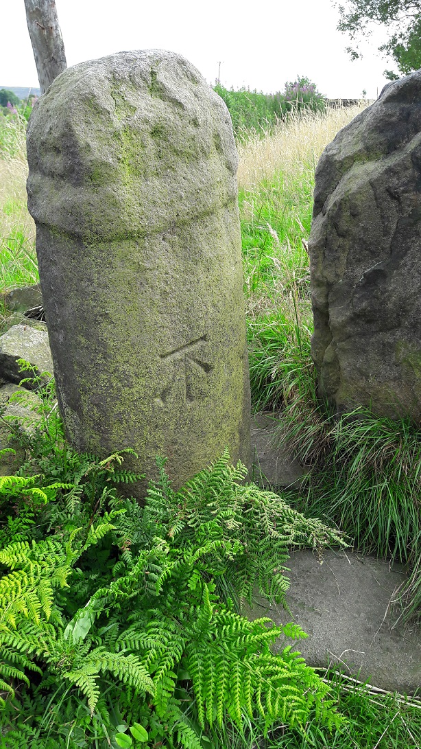
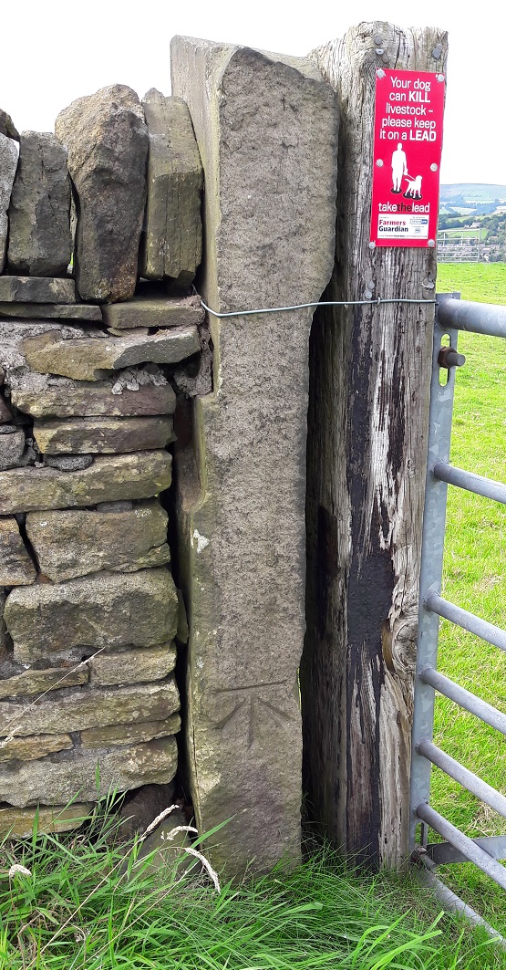
The Whitfield Cross, now permanently marked by a Bench Mark.
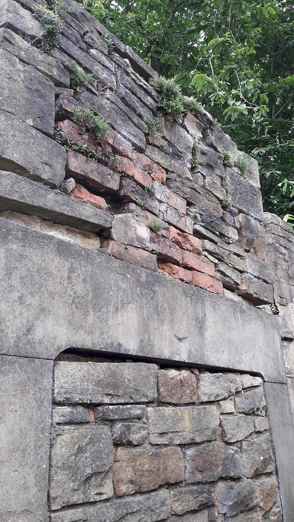
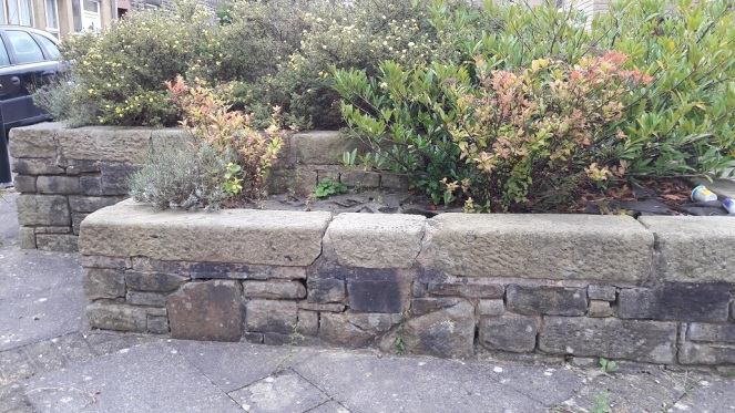
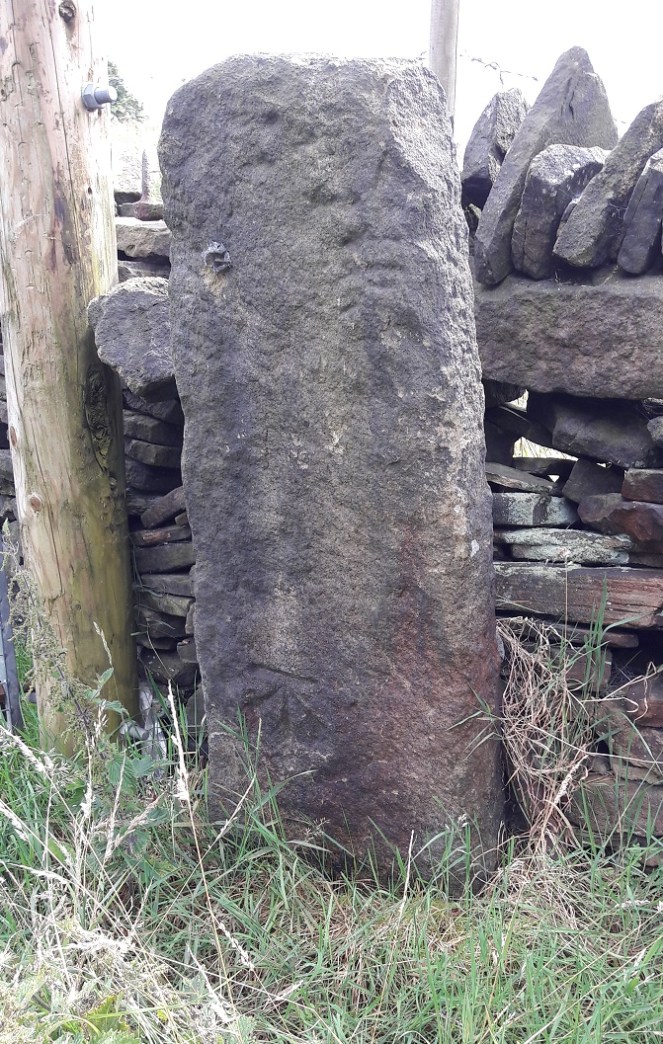
Technically, it is a 9th Century Mercian Round Shaft. That is, it is Anglo-Saxon in origin, carved and placed sometime between 800 and 900AD, and is of a type that is only found in this relatively small geographical area, the kingdon of Mercia. I say ‘this’ area, but technically we are living in the land of the Pecsaetan – the peak dewllers – an independent tribe until they merged with the Mercians prior to the invasion of 1066. Crosses normally have square or rectangular shafts, but the Round Shaft are characterised by an almost pot-bellied round shape, and the very characteristic band around the neck below the cross itself. Sometimes the shafts are decorated, but more often they are plain, as is our cross. Originally, it would have had a simple cross form on the top, just above the collar, and this as well as the neck, could sometimes decorated in panels. There are a few other examples of the round shaft in the area, but the closest are Robin Hood’s Picking Rods (which will be the subject of a future post).
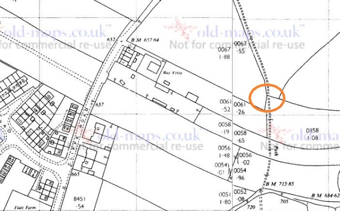
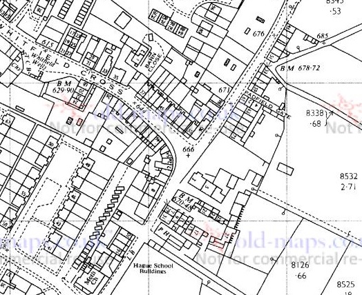
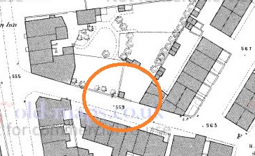
Hamnett suggests that the original location for our cross was at the Whitfield Wells, and the early maps show an area set back from the road that would work. However, it would make more sense for the cross to have stood at the top of Whitfield Cross (the road) as crosses of this sort usually mark road junctions. Here, there is the meeting of three (then) important roads.
The location of the cross would have been where, coincidentally, the cross is at the centre of the map. That cross represents a ‘spot height’ above sea level, but the fact that figure is 666ft is deliciously ironic.
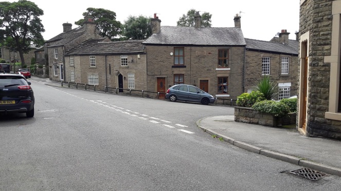
The old pack horse route comes from the south (Peak Forest, Buxton, and Chesterfield) through Gnat Hole, along Hague Street, through to the appropriately named Cross Cliffe, down to Old Glossop (for local traffic – the market and the parish church on Sundays), and on to Woodhead (and Yorkshire beyond, for commercial traffic). The stone would have marked the junction of the track that went along Whitfield Cross, Freetown, Hollincross Lane (Holy Cross? A cross standing by, or covered in, Holly?), Slatelands, and onto Simmondley and beyond. There was another spur coming out along what is now Gladstone Street, leading to that area of the town, and again onto Woodhead.
The location of the cross would have been dead centre. The roads all widen out at this point, presumably to have accommodated the cross. Left is to Peak Forest/Buxton, right down Whitfield Cross to Simmondly, behind the camera leads to Old Glossop/Woodhead
As we can see in the top photograph, the height of the land on either side of Whitfield Cross (the road) is surely testament to the age of the trackway, it being worn down to its present depth by millennia of use.
Neville Sharpe in his masterful study Stone Crosses of the Peak District notes that there are several large pieces of large built into the wall at the junction that could have formed the cross base. Closer inspection reveals numerous stones that have been re-used in the wall, several of which could be related to the cross, but without dismantling it in search of sockets, we can’t be certain.
A section of walling – note the reused stone, any one of which could be part of the cross base.Likely candidates?Another candidate? Ignore the arrow, that was carved to indicate an electricity supply is buried there.Another candidate?Whilst looking at the wall, I spotted this dressed stone. It seems to have been a capstone to an arch – the curved line at the bottom gives it that impression, as does the diagonal sides. A doorway? A bridge? The rectangular panel has been deliberately pecked, perhaps to remove a date or name, or even a carving. I would suggest that it is early in date judging by its dressing – medieval perhaps? It’s amazing what you see in walls!
According to Sharpe, John Nelson, an assistant to John Wesley, preached at the cross in the mid 1700’s. This is very typical of the Wesleyan way – preaching outside and using a local landmark – and I’m surprised that Wesley himself didn’t preach here, given his activities in and love for the area. Alas, there is no mention of this is his diaries. There is a very interesting piece about the history of Methodism in the area, including a biography of Nelson, here.
I wonder how many of those dog walkers and hikers are aware of what it is they are passing by when they use that stile? Seriously though, I urge you to go and see it – it is truly a remarkable piece of history, and one that deserves a better fate than is currently befalling it.
I have a big idea about the cross! I would love to see it restored to its original site, or better yet, outside the Whitfield Wells, with a little placard explaining the history of both. The setting is perfect, and it would surely be a fantastic companion to the wells, particularly when dressed. Although in the infant stages, I am exploring possibilities… watch this space.
The cross would look perfect here, especially if the wells were decorated.
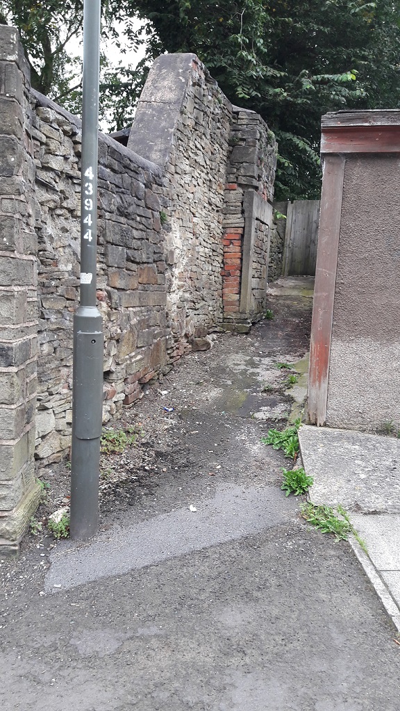
As you walk down Freetown toward St James’s church, just before you get to Charlestown Road there is, on the right-hand side, a small thin passageway that ends in a gate, probably leading to someone’s back garden or something. Now, I’m not sure if this private land as such, but I don’t think so. It is, rather, one of the anomalous bits of land left over after the extensive demolition and remodelling that this part of Whitfield underwent in the late 1960’s. A sort of architectural no-man’s land, the result of imposing a rigid housing plan onto an already existing street system, and one that had grown somewhat organically, and in a ramshackle and piecemeal way throughout the 19th Century. It doesn’t quite fit, so there are these angles and nooks left over which I like to explore. I never can resist a good nook!
Innocuous enough, and overlooked.
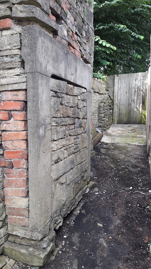
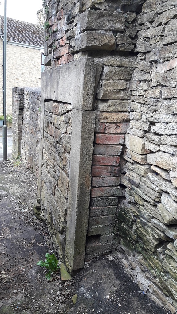
This one contains a bit of a surprise. A fireplace. A large inglenook fireplace made up of three stone – two uprights and a lintel – carved, dressed, and sitting proudly in the wall, exactly as it should be.
Except it’s not… it’s outside.
What you see is the front of the fireplace – as you face it, you would have had your back into the room. But there is no room.
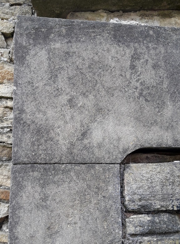
Given the size of the fireplace, and the cramped location, it is difficult to get a good photograph, so my apologies.The dressed surface and delicate lines are clearly visible. The walls around it would originally have been plastered and flat, once you get that, you can begin to reconstruct the house around the fireplace structure.
Now, putting my anthropologist head on for a moment (as we archaeologists do fairly often), we may note that humans almost universally, and throughout all periods of history, have placed great importance between the ‘outside’ and ‘inside’. This binary concept is prevalent throughout our lives, and is just about hard-wired into our brains. The inside of a house represents the safety of the domestic and the social, the known familar world, one with distinct limits (the walls), and one that is warm and safe and light. The exterior is the opposite of that – it is dark, wild, cold, dangerous, full of unknowns and without limits. Out there, we are helpless, alone, and out there, man is no longer the hunter, but is the hunted, pursued by predators. Consider too the garden; technically outside, it can be seen as symbolically taming the wild. It is outside, but is not – it is bounded by walls and fences, and the grass is cut, unwanted plants are weeded out, the trees are nurtured and the flowers are fed and watered – it is controlled by us, and is carefully and jealously guarded against incursion from the wild.
Arguably, the whole of humanity’s struggles and the evolution of society is based around this concept – making the distinction between outside and inside, developing the domestic, and keeping the ‘other’ at bay. Certainly the ‘Neolithic Revolution’ is as much about this as it is about farming, and the two go hand in hand.
The bricked up central part seals its fate as merely part of a wall.
Now what, I hear you cry, has this got to do with a fireplace? Well, the fireplace or hearth is the embodiment of the domestic, the heart and soul of a house. Warmth, light, food, and safety all come from this one point, and it physically and metaphorically represents the concept described above; beyond the light of the fire is darkness, and we don’t know what lies in the darkness. To see it outside, the exact opposite of where it should be, is, anthropologically speaking, wrong – it is an inversion of the norm, it is unsettling and disturbing, and it is somehow dangerous.
Taking off my anthropological head, it is also a very nice piece of carved stone, and so it’s a shame to see it wasted like this. Indeed, I have a fireplace exactly like this one in my own house.
So, how did it end up here? Taking a look at various historical maps, there are a number of buildings marked here over time. The earliest, 1880, seems to have been a small outhouse, possibly a privy. The others are a bit more substantial, particularly that shown on the 1898 map, which may well be our source.
1880 1:500 map. A small outhouse or privy?1898 1:2500. A more substantial building.1921 1:2500. The building is now on an east-west axis.
The remodelling, probably largely uneccesary, of Whitfield has thrown up some interesting anomalies (not to mention the re-use of some of the original housing stone – see photos), but I think this is the oddest.
Re-use of the original building stone of the 1860’s houses of Whitfield and Freetown. These form the front garden wall of some of the 1960’s built ‘new’ houses.Doorway lintels, foundation stones, and window sills make up part of this planter on Freetown.
As always, comments and corrections are very welcome.
During the sunny weather we had a few weeks ago, James (my son), myself, and some mummy friends decamped to Manor Park for the swings, slides and climbing frames. Now, James is 18 months old and desperate to explore the world around him, so when we decided to plonk our children into Shelf Brook for a spot of paddling and water-based hi-jinx, he took to it like a duck to… well, you get the idea. The brook at that point is shallow and slow moving, perfect for picking up stones and throwing them, something he loved doing.
But it is, I have noticed, also a great place to find bits of pottery and other interesting bits lying in the brook. This was our hoard for the day:
They don’t look like much, but I like them!
I found the piece on the left, immediately recognising it as part of a marmalade jar – it is a gray glazed stoneware, with characteristic vertical ridges on the exterior. I say marmalade, but actually they contained all sorts of preserved fruit, with a paper label pasted onto the exterior to say what is within. Date wise, they are long-lived… so anywhere between 1870 and 1920, or thereabouts. You can still buy them, sometimes with the labels intact, quite easily – on ebay for example. Here’s what they look like when whole:
I actually have a whole one that I managed to piece together from a dozen sherds I found on a Victorian tip, and it now holds pens and pencils. Sherds of this type are quite a common find, and as they are so recognisable you start to see them everywhere, as future blog posts will show.
The sherd on the right was actually found by James – a proud father/son moment… his first piece of pottery! Of course, being 18 months old, he simply threw it back into the brook where it made an audible ‘plop!’. It’s a sherd of roughly painted, almost sponge ware, pottery, and quite a lovely one too, with a sort of floral leafy design in a beautiful blue colour. It is difficult to see what the original form of the sherd was – probably a bowl or plate. The date is difficult, too. I would guess Victorian, and potentially early Victorian.
Both of these sherds have been rolling around the Shelf Brook for 100+ years, and the wear pattern on each tells that story. Both are discoloured by the peat brown water coming down from the moors – the marmalade jar particularly so – and both show signs of worn edges. The longer a piece of pottery has spent being tossed about by the water and banging into stones, the more worn it gets, and eventually the edges will become so rounded that it resembles a pebble. The marmalade jar has comparatively sharp edges, but this is probably due to the fact that, as a stone-ware, it has been fired at a higher temperature and is very hard wearing. The decorated sherd is less fortunate, and has already become rounded at the edges. Interestingly, the glaze on this sherd is crazed – that is, it is covered in tiny cracks. Heat is the usual cause of this, and as it is not a cooking pot, we may assume that the vessel was at some stage placed in an oven either to heat up, or to keep food warm, and probably many times before the vessel was broken.
As we were pulling the sherds out of the brook and looking at them (there were plenty of them, but these were the two that caught my eye), my friend asked “how did they get here?”. Actually, a very good question.
There are potentially two ways. The first is that there is a Victorian tip upstream somewhere, and the material is washing out of the bank. Possible, but I don’t know of any tip upstream (not that that is a guarantee of anything). The second, more probably route, is that at some stage along the course of Shelf Brook, someone threw the pottery into the water. Humans are essentially lazy, and it is almost an archaeological law that people will only move rubbish as far as they have to in order to no longer be able to see or smell it. And no further. The brook offers a perfect place to dump waste and rubbish, and as pottery is virtually indestructible, it washed up here in the calm and shallow area before the sluice. For all the good they did us, the Victorians were some serious litter louts.
Anyway, as usual, keep your eyes open, and any comments, please let me know.
I found an interesting thing the other day. I was walking down Bank Street, down to Milltown on the way to the park. For those of you who don’t know it, it is a cobbled path (setts, actually!) that winds its way through demolished mill-scapes, and which allows access to High Street East. I nearly wrote ‘easy access’, but with a push-chair it is a nightmare! That said, I really like it. It has the air of a long forgotten path, Tolkein-esque, leading to who knows what adventure.
The path through Mirkwood, to the Lonely Mountain!
I want to do a longer post on Bank Street at some stage in the near future – it is interesting and full of history. It was originally believed to follow the path of a Roman road, although more recent research suggests, however, that this is in fact an early-modern (16th Century or so) track.
However, for now, I want to share my find.
The screw-thread can be seen winding around the base.
It is a bottle stop made from vulcanised rubber. It had eroded out of the side of the path from behind a partly ruined wall, and was just lying on top of a trickle of soil on the left hand side going up. The screw-thread winds into the neck of a thick-walled glass bottle containing a carbonated liquid – often a soft drink such as water, but also beer. Originally it would have had a soft rubber ring around the cap that would form a seal to keep the drink fresh until it was unscrewed. The design was patented in the early 1880’s by Henry Barrett, and immediately became very popular, with various design improvements ensuring the basic concept was in use for nearly 100 years. Generally speaking, though, the date of such a screw top is roughly 1890-1920, after which time the crimped rim top became popular. There is a really interesting website that details quite a bit about these bottle stops here.
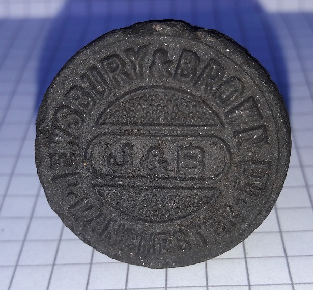
More interestingly, and as was quite common, the top of the screw cap carried the logo of the company manufacturing the drink inside the bottle – in this instance, the company is Jewsbury and Brown Ltd, Manchester.
Jewsbury & Brown Ltd. Manchester. The preservation on the bottle top is wonderful.
Jewsbury and Brown were a large company founded in 1826 and based in Manchester, their premises being at 113 Market Street, and later Ardwick Green. They produced carbonated drinks that were sold in Lancashire and the north, and beyond, until they were bought out by Schweppes in 1964. A bit of internet research reveals that they specialised in non-alcoholic carbonated drinks, fizzy water, and toothpaste – but, disappointingly, never beer! Here is a bit of their history, but much more is available online with a little search.
I love this – not just a bit of archaeology that quite literally threw itself at me, but a real tangible insight into the lives of those of the past. There was nothing else associated with the screw-top, and one gets the impression that it was simply unscrewed from the bottle and thrown over the wall, the thrower determined to drink whatever was within the bottle in a single sitting. Let’s imagine them walking along that uneven path when they did it, clogs striking the setts, perhaps on a hot summer’s day, and at the end of a long shift in the mill, appreciating the fizzy drink playing on their tongue… 100+ years ago.
It’s a neat little thing, and one that will be added to the collection. It also makes me wonder what else is behind that wall, waiting to tumble out, so keep your eyes peeled!
Some years ago, whilst walking to the station for my daily commute, I passed down King Street in Whitfield. As I approached the middle of the street, I had to skirt around some scaffolding that was placed onto the front of a house, and projecting into the path. As I passed, I looked down and saw, scattered quite literally all over the the path, dozens of pieces of thin green metal. On closer inspection, I could see they were copper nails, and promptly pocketed all that I could see.
Fistfulls of copper nails!
The roof of one of the stone-built terraces on that street was being replaced and the copper nails were the fall out, having been removed during renovations. They had been used to pin the heavy stone roof tiles in place, each one carefully nailed into the timber through a hole drilled through the stone tiles, and now, no longer needed, they were simply tossed aside onto the street to be swept up. Now that is, I think you’ll agree, a shame; these little pieces of history deserve better! And besides, I can’t resist picking up interesting, and sometimes shiny, things!
The nail second from right has clearly hit a knot or some similar obstruction and folded. One wonders what expletive was uttered by the workman when he saw it bend… and then carried on hitting it in order to get the job completed as speedily as possible.
They are formed from copper, rather than iron, because copper doesn’t decay the same way iron does – it maintains its strength for far longer, resisting the elements and doesn’t turn to rust. Ship’s nails are made from copper for the same reason. Instead, it develops a thin green patina called verdigris, which makes them particularly beautiful to look at, especially when the verdigris is partly sanded off.
A very bad photograph to illustrate the sun shining off the copper, contrasting with the matt green of the verdigris. These things are difficult to photograph, but very pretty!
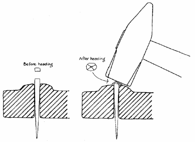
They are also hand made – each one cut via a press from a long flattened strip of copper, which accounts for the square body of the nail. It is then placed into a small mold or former, point down, and the exposed top is hammered by hand until it flattens out, forming the nail head, like this:
Illustration taken from ‘Nail Chronology’ by Lee H Nelson (American Association for State and Local History, 1968 )
This method accounts for the thin flattened strips on opposite sides of the nail, just below the head – the former is made of two adjustable halves to enable different size nails to be made, and when pressure is applied via the hammer, the copper is forced into the gap between the two halves of the former.
These nails date from the early to mid-19th century – I seem to remember reading somewhere that the houses in King Street were built in the 1860’s, and, one assumes, the nails are contemporary.
That said, my own house, which dates from the late 1840’s, originally had wooden oak pegs holding on the roof stones. When we replaced the loft insulation, we found dozens of them lying on the floor of the loft where they had been thrown down.
What I love about these is that you can see each the stroke of the knife that was used to form the pegs – in the photograph above the peg at the top was made using eight strokes, the middle using seven strokes, and the bottom peg using eight.
Whilst being fun and interesting artefacts in themselves, there is a sense of connection with the human in these objects; both have been formed by hand, and the mark of that hand is visible in both – the hammer and the knife. That for me is what makes archaeology so fascinating, connecting to past people through the objects they made and used, and the story they tell us.
Update.
Whilst taking advantage of the sunshine to do a little gardening, I came across this little piece amidst the great piles of stone that originally littered our garden – a stone roof tile. It is very small, and is presumably a broken fragment, which explains why it is no longer on our roof. What is fantastic about this is the fact that you can see the hole that would have originally taken one of the pegs illustrated above. I love things like that!
The peg hole is top right of this broken tile – you can clearly see the traces of the boring that created it – and it is a perfect size for the oak pegs shown above. The break in the middle is new, though – I think I may have trodden on it!
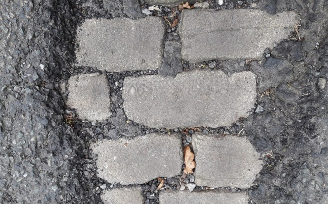
I walked down to Manor Park the other day, along Cliffe Road and through Milltown. I seem to do that a lot recently… the joys of having an 18 month old who is obsessed with swings. At the bottom of the hill, just before the road becomes Milltown, I noticed that the tarmac surface of the road had come away to reveal the original road surface underneath. Fantastic, and an opportunity for a new blog post. As an archaeologist, you find yourself, as a reflex and completely unconsciously, looking into any hole you see in the ground – like a moth to a light, we cannot help ourselves. I have often seen holes in and around Glossop that have broken through the original surface in order to access a sewer or some such, the stones piled up by the side of the spoil heap. But it is really nice to see the stones in situ, as they are here.
Technically, these are setts, not cobbles – these have been quarried and shaped by hand, whereas cobbles are naturally shaped and have simply been taken from a beach. So there you go.
I love the thought that not so long ago, people would have swarmed over these stones on their way to work in the mills, hob-nailed clogs striking the surface, chattering and joking. And that now, by chance we might be able to do the same. And with that thought in mind, I drove James’ push chair over the cobbles… and nearly pitched him out of it as the wheels jammed on the uneven ground!
No doubt the council will come along soon and fill it in, which is understandable and probably the right thing to do. But I can’t help be a little disappointed. Enjoy the sight of this little peek at history whilst you can.
The previous post about the date stone reminded me of something I read a few years ago. It took me a while to track it down, but here it is.
Melandra Roman Fort is one of theplaces that you have to visit in the area if you have an interest in the past. It is situated at the edge of a dreary housing estate, and has a slightly desolate air about it, particularly the car park. But turn your back to the 1960’s built houses, and face out, standing at the centre of the AD 60’s fort, you really understand why they built it there – you can see all along Longdendale, across Glossopdale, and on the promontory it reaches out almost to the bank of the Etherow, which it overlooks for a long way either way. Strategically, it is a perfect place – commanding the area, yet safe and secure.
The area was known as ‘Castle Yard’ since time immemorial, and when it was first described in 1775 by Reverend John Watson (in Archaeologia Vol 3) the area was untouched by the plough, and the full fort could be made out by standing walls. Incidentally, it is likely that Watson made up the name Melandra – there is no record of anyone ever calling the field by that name before 1775, and crucially, Melandra is Greek in origin. I’m not certain, but I think we can go out on a limb and suggest that no rural Derbyshire farmer spoke classical Greek in the 18th Century. It’s actual Roman name seems to have been Ardotalia, a word vaguely associated with the name of the river, Etherow.
Over the years, the local farmers used the walls as quarries, building houses, walls, sheds and the like with the dressed stone found there. Amongst them, inscibed stones were found – probably one inscription placed above each of the four entrances into the fort, with more, and an altar, inside. One farmer had even built an inscribed stone over his doorway. However, not everyone understood the value in these inscriptions… I’ll let my pseudonym tell the story:
“Previous to the reservoir belonging to the Manchester Corporation being made at the Hague on the Cheshire side, the river Etherow was undermining the bank, and it was found necessary to build a wall to prevent its encroachments. For this purpose the workmen took away all the stone then lying at Melandra, and amongst them was another inscribed stone. One of the men had no knowledge of its antiquarian value and built it in the interior of the wall, though a bystander remonstrated with him for doing so, using these words in the local dialect: “thart puttin summut in neaw ut ul be wanted sum day”. A few days afterward, Mr. Bennet Woodcroft, a gentleman visiting in the neighbourhood, hearing of the matter, went to the place and offered £5 if the workman would recover the stone, but the clerk of the work would not permit the wall to be taken down, as the exact spot it was could not be accurately located”
Hamnett, R. 1899. “Melandra Castle” in Derbyshire Archaelogical and Natural History Society 21: 10-19
Amazing to think that there, on the banks of the Etherow, lies an unknown Roman inscription, bricked up by some ignoramus who couldn’t recognise its value beyond being just a piece of stone. Which makes me even more thankful that history didn’t repeat itself on the banks of Glossop Brook.
EDIT: Just out of interest, I just ran a quick value equivalency programme – £5 in 1850 is today worth about £500 – a significant sum of money.
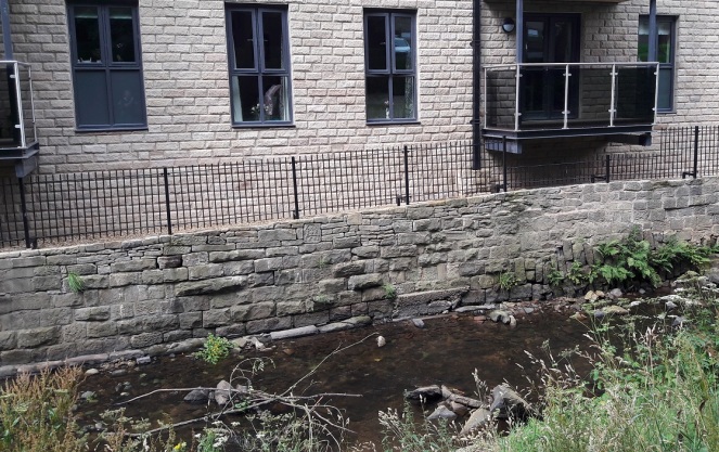
I was coming back from a visit to the supermarket the other day, and thought it would be a nice stroll, with James in the pram, to go along Glossop Brook and through Harehills Park up to the Market.
Now, if I may digress for a moment, despite the presence of a plaque, I steadfastly refuse to call this ‘The People’s Park’ which is an entirely new invention… and sounds absolutely awful. Even the name Harehills is of recent coinage, dating only from 1921 when the park was given to Glossop by Lord Howard to Glossop in memory of his son who was killed in the First Word War. Prior to that, the rough unused ground was known simply as the Sandhole – named, presumably, for the sand that was quarried here. Indeed, during the Cotton Famine (1861-65, caused by cotton no longer available from America due to the ongoing civil war there) Lord Howard employed the jobless mill workers in the area to dig sand – in essence giving them a paid ‘non-job’ so that they wouldn’t starve. He was alright, was that Lord Howard bloke! The area is still sandy, and indeed sand covers the footpath at one point along the way.
The location, on the brook, is lovely, and several developments have recently brightened up the area, including the redevelopment of the Old Glove Works on George Street (into flats, one assumes, but that is better than a derelict building). The new retirement flats just opposite the park itself went up surprisingly quickly, and look rather nice. However, if you poke your head over the side of the brook (carefully) you can see all sorts of history – dressed stone, drains, the old bridge, etc.
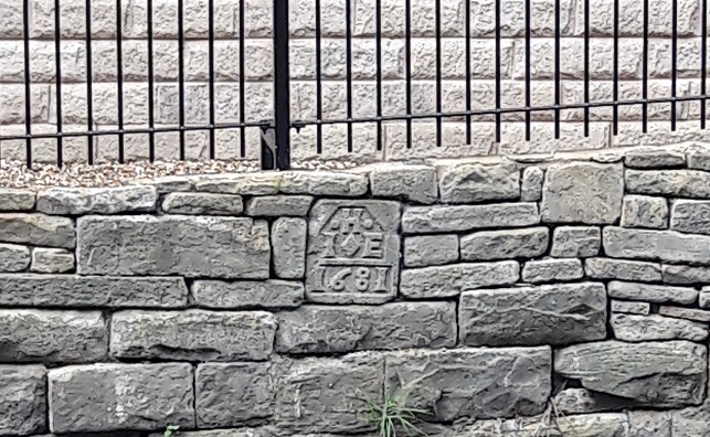
As I was pondering the detritus of history, I noticed a date stone had been cemented into the newly built wall adjoining the brook. Hmmm… I thought.
Difficult to see, but just there, on the upper course of stone, a bit to the left of centre.Close up. J and E H.
The date is 1681, refers to the date of the construction of the (now long gone) building to which the stone belonged, and the letters refer to the people who built it, usually a husband and wife. In this case, their initial would be, I assume, I (or J more likely) and E, and their surname began with H. This is important, as 1681 is a particularly early date for a building in Glossop – the Bulls Head pub in Old Glossop, usually reckoned to be the oldest building, has a date stone of 1607. I’m sure someone out three would be able to work out who they were and to what building the stone belonged, but it is beyond me I’m afraid. I am just glad that someone though enough about history to cement the stone the right way round in order to provide us with this little mystery.
As usual, any thoughts, comments, or general pointing and laughing, please drop me a line – email or comment below.
Following on from the original Bench Mark post (here), I thought I would have a look around and see if any others were nearby. And so, after a fun evening spent poring over old maps, making notes, glass of wine in hand, I thought I’d spend a few hours stomping around Whitfield trying to find the lost Bench Marks.
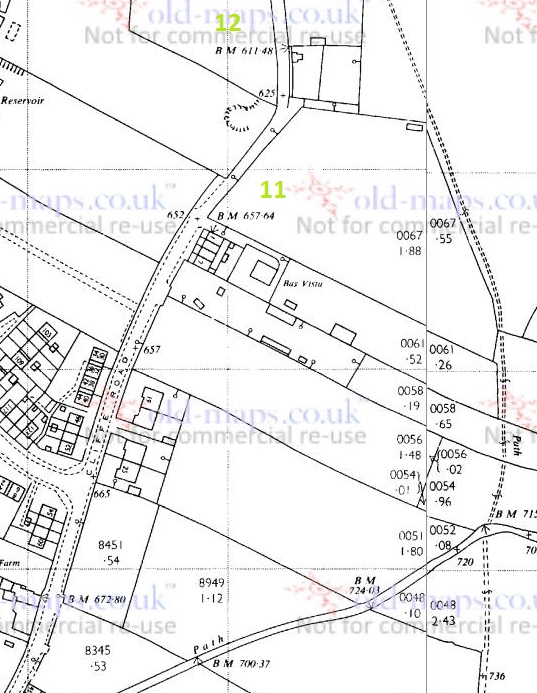
I have used the 1898 1:2500 and the 1969 1:2500 Ordnance Survey maps. There are differences; marks have clearly disappeared, to be replaced by others, buildings have gone, and land has become altered meaning that some marks are now on private property. Here are the maps with the Bench Marks numbered, the photos follow. There are more Bench Marks on the maps that I haven’t numbered yet – I will update the blog when I get round to looking for them!
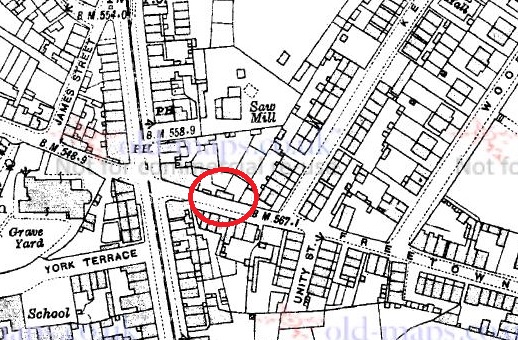
The 1898 1:2500 OS Map. Cliffe Road runs SW-NE, Whitfield Cross is just off the bottom left, and The Beehive pub is down, Volcrepe and Old Glossop are Straight up. The numbers in red correspond to photographs and discussion below.
What follows are the photographs I took of the various remaining Bench Marks, their number corresponding to that on the map.
1 (679.1 ft above sea level) Tucked away at the side of the house, and quite worn. I wonder how many people living in these houses know they are there?2 (700.8 ft above sea level) Clear on a wall on the path.3 (728.8 ft above sea level) Marked on a gatepost
4 (698.8 ft above sea level)
Originally on a wall running down to Cliffe Road, and now on private land. It may well be still there, but I wasn’t able to see. It is not marked on the 1969 map.
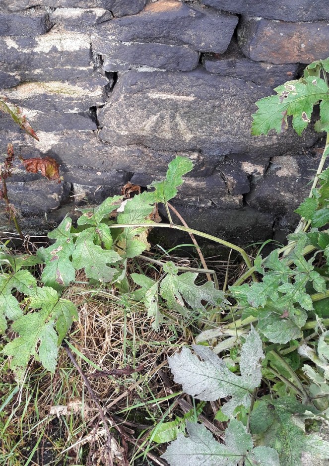
5 (716.2 ft above sea level) Another gate post, and again very clear and fresh.
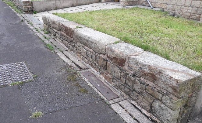
In between Marks 5 and 6 you pass through this stile.
Now, I will post more about this stile later on as I think there is a lot more going on here, really quite interesting things, and it deserves its own post.
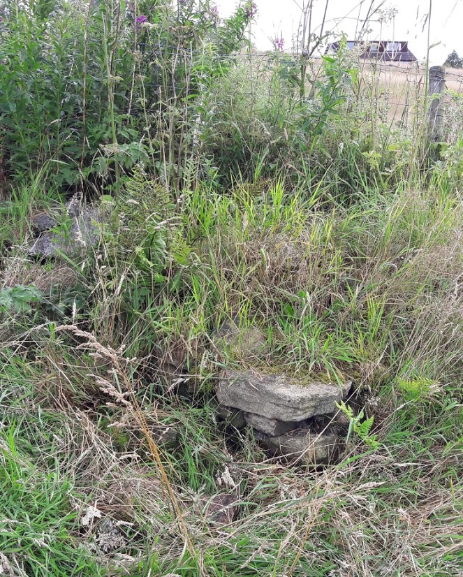
6 (682.0 ft above sea level) This is a particularly important bench mark as it has been placed on the actual Whitfield Cross. THE Whitfield Cross. The cross was moved from its original position at the top of Whitfield Cross (the road) in the 1790’s and ended up as a stile post in a field. The cross itself is Saxon in date (probably 9th Century) and is of a type known as a Mercian Round Shaft. You can see the band around the top that both dates it… and makes it look somewhat phallic! I will go into a lot more detail about the cross in a later post, as I think it is one of the most important pieces of history in the area, and one of the most overlooked, but for now, let’s move on
7 (682.6 ft above sea level)
Again, on a wall that is now on, I think, private land. I did have a quick look, but couldn’t see anything, so I left it and moved on. This Bench Mark is not marked on the 1969 map.
8 (636.7 ft above sea level) Originally on the corner of a retaining field wall. I searched high and low, even pulling over the stones that had fallen down hoping to find the mark, but to no avail. I suppose a full-scale excavation might uncover the stone, but I’m giving it up as a lost cause. It is not marked on the 1969 map.9 (627.3 ft above sea level) A similar story here, too. The stone has gone missing, perhaps one of the stones at the top that has collapsed down, although the wall itself looks like it has been rebuilt at some stage which may explain its absence.10 (671.8 ft above sea level) Flatt Farm, on the corner of the farm building, and very difficult to see. It took me a while, but the level of the pavement has risen in the last century or so, leaving the level just visible above the tarmac surface, the arrow now buried below.
Moving onto the 1969 map, there are two additions: 11 and 12. The Bench Marks that are not on the 1969 map have been noted above.
11 (657.64 ft above sea level) This one should be on the corner of the last house on Bright’s Terrace – the last row of houses on Cliffe Road. I found no sign of it, and it is probably hidden behind the flower bed.12 (611.48 ft above sea level) A little down the hill on the right, clear on a wall.
And so ends my brief sojourn – both geeky and fun. I have done a bit more Bench Mark walking, and I’m sure they will feature in future posts, but that’s it for now.
Incidentally, both maps are available for free from http://www.old-maps.co.uk a truly marvellous website that has old Ordnance Survey maps for the whole country dating back to the mid 19th Century, and all for free. Seriously, if you find any of this interesting in any way, hop over and have fun!