What ho! dear readers. I’ve just opened a bottle of fine Belgian pilsner, and am feeling quite effervescent, if that’s the word I’m fumbling for. I think it probably is.
Talking of fumbling, I went back to the place I found the lead came and had a fumble. Madam, please! This is a family blog. Honestly, some people! So there I was, fumbling, looking to see if anything else popped up, when I found what looks like window glass and some early pottery. Hmmmmmmm, let’s take a closer look.
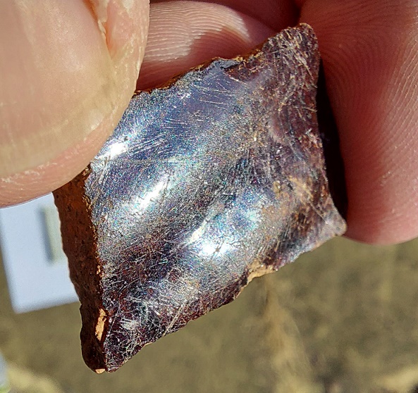
Small and fairly unimpressive – I nearly ignored it. Shame on me!
The glass is only a small fragment – just 2cm x 1cm – and very thin, being a shade over 1mm thick. It is also flat, which just about rules out its origin being a bottle. I terms of colour, it has that blue-green tinge that you associate with early glass, before they managed to perfect the process to remove all the impurities. Looking more closely at it, I noticed that two of the edges were flat, and pulling out my new toy – a usb computer microscope that also takes photographs – I was able to see – and show you – tiny teeth like nibbles that tell me that the glass had been cut and shaped.
I’ve had a lot of fun with the microscope!
Now, I know a lot of useless information – for example that glass is shaped by nibbling – but I’ll admit that even I had to look up how exactly this was done. With a ‘Grozing Iron’ it turns out (see, don’t say you don’t learn something by reading this blog, although I can’t see it coming up in a pub quiz anytime soon). The verb is ‘to groze’, and the above glass fragment has been ‘grozed’. It looks like this:
A grozing Iron, image courtesy of the York Glaziers Trust who have a fantastic illustrated glossary, if you are in any way interested in glass.
So, it was shaped… but to what shape? The two edges, if they were extrapolated, didn’t make a right angle, but instead, a diagonal. A diamond, even. Could it be I have a fragment of the glass that went into the lead came I found? Impossible to say for certain, but it is possible, even probable. In terms of date, it’s very difficult to say. Broadly speaking, the thinner the glass, the earlier it is, and combined with the colour could certainly put it in late 17th or early 18th, which matches the tentative date for the came. So that’s exciting, if you get excited about this sort of thing… and I do! Here it is situ:
I added the came for effect – perhaps reuniting them.
The date of 18th century also matches the date of two sherds of pottery I found with the glass.
Again, quite small and uninspiring.
They are both mottled manganese ware, and classically early 18th century in date – certainly not later than about 1760. Interestingly, they are not particularly worn, so it’s unlikely that they have been kicking around for 250 years or so – perhaps there is a dump nearby? They are also both open vessels – bowls, probably – and may belong to the same vessel, despite one being glazed on the inside only (quite often, the glaze on the exterior was confined to the top part only). Also, one sherd shows the characteristic manufacturing marks, that also doubled as decoration:
The horizontal lines visible in the clay, formed on the potter’s wheel. Also, if anyone want to donate to the ‘Robert Hamnett Needs a Manicure‘ fund, please feel free…
The next photo shows the make up of the sherd – the reddish slipped exterior (top), the rough orange-brown earthernware fabric with tiny bits of stone in it (middle), and the thin dark line of the glazed interior (below). I love this stuff.
Lovely stuff!
I’m going to put together a quick and easy guide to pottery, describing all the different ‘parts’ of a sherd, and some tips on identifying what shape and size, as I think it’s nice to now what it is you are holding. I’m also still putting together my quick and dirty guide to Post-Medieval pottery, as there is a serious gap in the market… probably for obvious reasons!
I’m going to end with a great photograph of the glass, and to pose the following questions: Who was the last person to look through that window before us? And what did they see?
Makes you think.
Until next time, take care of yourselves and each other. And I remain.
What ho! Hope you are enjoying the summer so far. A quick post today, but more very soon.
So, I know I promised you pottery this time, and I can tell you are wildly disappointed, but this is an interesting bit of history. Honestly. It really is. Don’t just look at the first picture and yawn… Philistines.
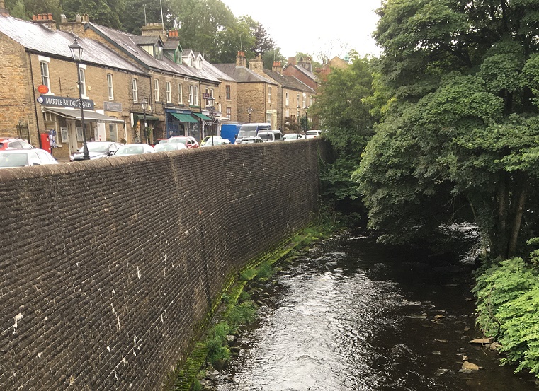
There are a number of places around Glossop that never fail to produce some bits and pieces – Lean Town, Harehills, etc. One such place is at the top of Whitfield Avenue. Never lots, but always a sherd or two, and this time a piece of lead. Window lead to be precise.
Lead is one of those substances that is instantly recognisable once you know what it looks like, and can be spotted from quite a distance. It doesn’t rust, or even really react beyond producing a white powder on the surface. It is soft, which means it can get damaged – in particular bent – easily, but it also means that it doesn’t break in the way that pottery or glass does, so it often survives. It is also worth remembering that it is highly toxic, so be careful when you handle it.
Don’t worry, I washed my hands afterwards.
So there it was, lying on the surface of the soil, a dull grey flash exposed after all the rain we have recently suffered. I would have picked it up anyway – I try and do that with lead, as it’s not great in the environment – but I knew at a glance what it was, and was excited as they can be interesting. I was not disappointed.
Window lead, or came as it is more properly known, has been with us for as long as there have been glass windows, and is essentially an elegant solution to a big problem – the fact that it is very difficult and expensive to produce glass in any large size. It is far easier to join together smaller pieces, and this was still the case until the 19th century, and why even early 20th century windows are made up smaller pieces separated by wooden mullions. But the multi-part aspect also allowed works of art to be created in the form of stained glass windows that adorned medieval churches and cathedrals, and is a fashion that continues down to today.
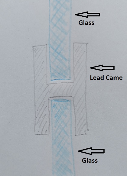
The came works by allowing separate pieces of glass to slot into its grooves, joining them together, with the whole being held in place by the window frame. In profile (that is, cut in half), came is broadly ‘H’ shaped:
A pretty awful drawing, but you get the idea… I hope.
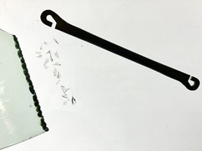
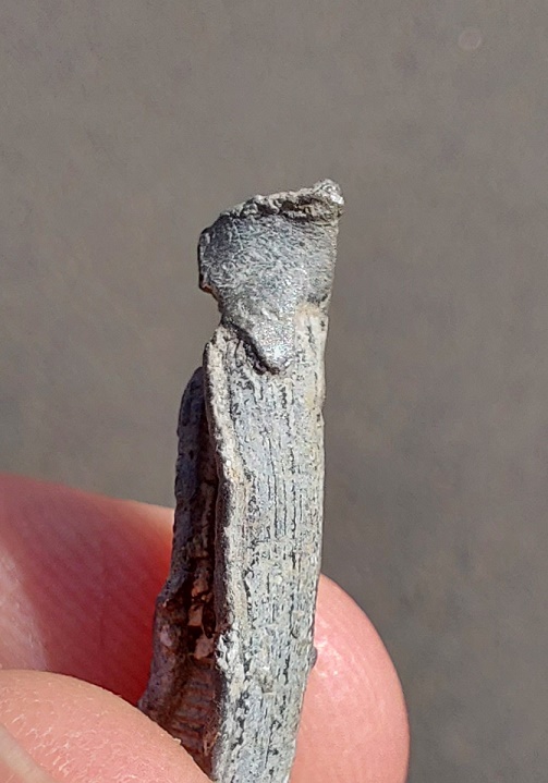
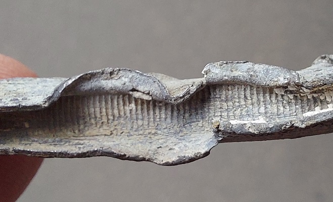
So then, what can we say about this little piece of twisted metal? Well, a surprising amount, to be honest. Firstly, rather than being poured and shaped in a mould, the came has been milled – the lead was drawn through a former by a cog. This means that it is not medieval, but instead puts it into the archaeological ‘misc.’ tray that is ‘Post-Medieval‘ (roughly, after 1500). We can, however, narrow it down a bit; the cog used in the manufacturing process leaves characteristic tooth marks on the interior. As the process was refined and improved over time, these marks grew further apart, and broadly speaking, the closer the teeth, the earlier the date. On our piece of came, they are very close together, and thus an earlier date is suggested.
Teeth marks, where the cog has pulled the came through the former.
This is backed up by the slightly rounded profile, which is also associated with earlier examples. We might suggest a date of perhaps 1700 – 1800, possibly earlier, but unlikely to be later.
Left: the slightly rounded ‘H’ profile, also slightly squashed. Right: the clean cut edge, probably by a knife.
It seems to have been cut cleanly at either end, which means it is the original length, which is significant. It measures just under 6cm, or 2 1/4 inches, so not very long, but a perfect size for the diamond style windows that were common in the 17th and 18th centuries, when whole windows were made up of smaller pieces and joined by the came. Look closely, you can see the tin solder that would have joined it to another lead came piece.
The melted end, but also marks where it was pulled through the former.
Looking even more closely, you can see the putty that would have weather-proofed it still inside the groove.
White putty visible.
Here is a 17th century window:
Typical Tudor & Jacobean diamond pattern window.
And here is our piece of lead in a mocked up window, showing how it would have been used.
Another rather poor drawing, but one hopes you get the idea.
How this piece of lead came came to be lurking in the soil on that rainy day is not certain, but it is in the right place – some of the oldest houses in Whitfield are right there, including Hob Hill Cottage with its datestone of 1638. The came must have originated in one of these houses, and at some stage either window was repaired, or replaced entirely. Indeed, if we look closely, we can see two marks where the lead flange has been lifted away from the glass to remove it.
The lead flange has been peeled back from the glass.
At that point, the lead has been lost or thrown away. I’d love to be able to say for certain which house it came from, and the obvious choice would be Hob Hill Cottage as it is just opposite the find spot, but in reality who knows? I am amazed at how much information it is possible to glean from what is, at first glance, just a small piece of twisted metal. And see, I told you it would be interesting.
More soon. As always, look after yourselves and each other, and until next time, I remain.
What ho, gentle readers! I trust you are all well in these trying times?
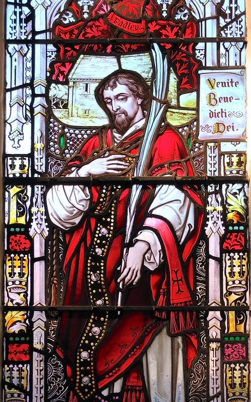
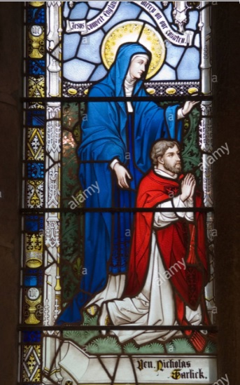
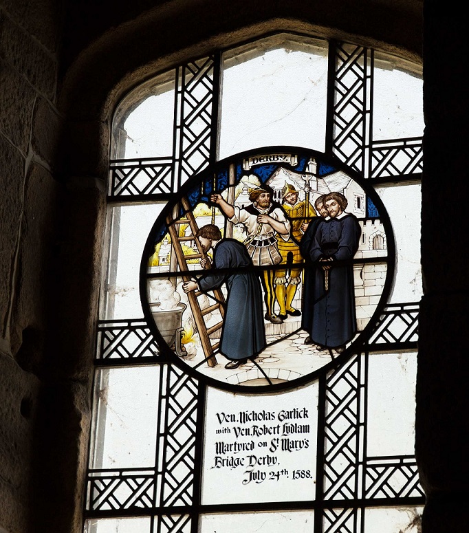
I’ve been wanting to make this post for a while, but I’ve only recently got round to doing the research. And my, it is a fascinating story of a turbulent period of history, and of a person who is much less well known than he ought to be – Glossop’s own almost saint, the Blessed Nicholas Garlick. Why I say ‘almostsaint‘ will become apparent, but here is a man who died a martyr, is venerated as such within the Roman Catholic Church, and yet – outside of St Mary’s Roman Catholic church here – he is little known about in Glossop. So, exactly 433 years to the day after his brutal death, read on.
The Blessed Nicholas Garlick. This stained glass window is in the Lady Chapel of St Mary’s RC Church, in Derby.
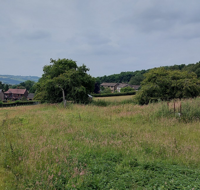
Nicholas Garlick was born in about 1555 in Dinting, specifically in the hamlet now known as Higher Dinting, here:
The hamlet of Dinting as it was, one of the original settlements that made up Glossop.
Dinting is one of the oldest parts of Glossop. It is mentioned in the Domesday Book (I discussed it in a previous post – here), and I find it fascinating that somebody has lived on this very spot for at least 1000 years. The original Robert Hamnett notes that the Garlicks are an old family in the area, and the isolated hamlet was their home until relatively recently. Indeed, it is still quite a common surname in the Glossop area, and would seem to be chiefly associated with this part of the world.
The hamlet of Dinting, nestled into Mouselow.
Dinting closer up. Surviving 17th and 18th century buildings cluster round this distinct place, far removed from what think of as Dinting – essentially the arches and the railway station.
Garlick was clearly an intelligent man and went to Oxford University, entering Gloucester Hall (now Worcester College) in January 1575. However, he lasted only 6 months at Oxford, and never graduated. Given what we know of his later actions, it is likely that he refused to take the Oath of Supremacy – something as a student he would be required to do – and was therefore dismissed. The Oath of Supremacy meant swearing acknowledgment that the monarch (Elizabeth I at the time) was Supreme Governor of the Church of England – something that a devout Roman Catholic simply couldn’t do, as he would have recognised only the Pope as the head of the Church. And here is the rub; Nicholas was a Roman Catholic in a time when Roman Catholics were mercilessly persecuted.
From 1533 onwards, Henry VIII’s ministers, led by the king himself, systematically dismantled the Roman Catholic faith in Britain, and replaced it with Protestant Christianity in the form of Anglicanism, and the Church of England. This was forced on the people, often against their will and under great duress, and much of what they had believed in prior to this was now declared ‘wrong’. I think it is difficult to overstate the effect that this would have on people, as the fundamentals of their religious world, that shaped their lives and structured their year, were upturned. Even simple things such as Mass now being celebrated in English, not Latin, or that praying for souls in purgatory, often loved ones, was pointless because there was no longer a purgatory. What was the simple man or woman to make of that? By the time Nicholas was born it was theoretically possible to be a practicing Roman Catholic, although you were known as a ‘recusant’ (somebody who refuses, in this case refuses to attend Anglican services), and were subject to heavy fines and social stigmatisation. However, the celebration of Mass in Roman Catholicism requires a priest, and both were expressly forbidden under pain of death.
After leaving Oxford he moved to Tideswell, near Buxton, and became a school master at the Bishop Robert Pursglove’s Grammar School for a number of years (the school was founded in 1560, and the later 18th century incarnation of the building still stands).
Tideswell Grammar School as it is now – a later 18th century building replacing the 1560 Elizabethan one.
His Catholic faith was clearly strong at this time, as three of his pupils later became priests, and one, Christopher Buxton, was himself executed for his faith.
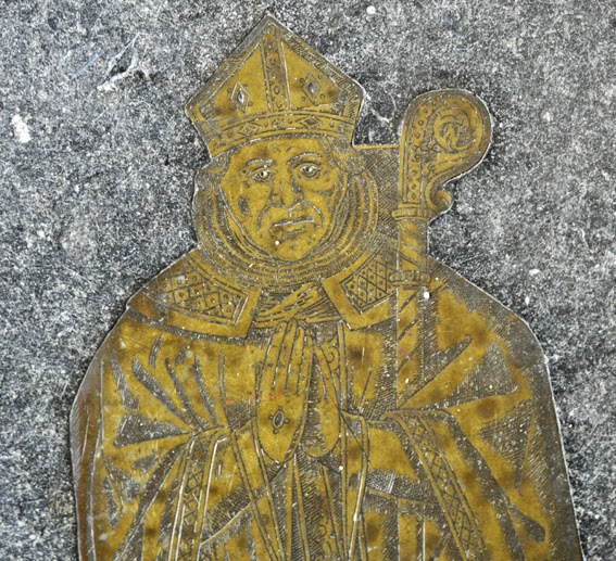
This is odd, though. Teaching of even a hint of Roman Catholic doctrine was expressly illegal, and could have landed Garlick a death sentence. So what’s going on? I dug around a bit, and it seems that Bishop Robert Pursglove who founded the school, and who employed Garlick, was an interesting character. A native of Tideswell, he was born in 1504, and later became a priest, then prior, then bishop. He seems to have swayed with the to-ing and fro-ing of the Reformation from Catholic to Protestant, and back again… and again. But, a little further research shows that he too refused to take the Oath of Supremacy on multiple occasions (something noted as highly suspect at the time), and an official Queen’s Council report of him records that he is “stiff in Papistry”, essentially he was clinging to the old religion, rather than embracing the new. He also enthusiastically embraced Queen Mary’s reintroduction of Roman Catholicism, becoming prebend of Southwell Minster, Nottinghamshire, during her reign. In addition, his memorial brass in Tideswell Church shows him in Roman Catholic Bishop’s dress, something that was also expressly forbidden by Elizabeth I.
Bishop Pursglove as a Roman Catholic bishop. The image is stolen from Distant Thoughts blog – written by a chap called Pursglove, and is an interesting read. Check out his mystery plate post, too. I’m dying to know more…
Pursglove also had strong connection with many recusant families in the area, some of whom were friends and relatives. North Derbyshire was known at the time as an area of strong recusancy, in particular in the area around Tideswell, and focussed on several local families – the Pegges, the Eyres, the Hunlokes, the Poles, and perhaps most important of all, the FitzHerberts. It seems, then, that the good Bishop played a significant role in that, even allowing distinctly Catholic teaching in his school. All this is speculative, of course, but the evidence does add up – Pursglove was probably a recusant Catholic. The fact that he was never investigated, arrested, or even publicly chastised, despite playing fast and lose with the rules, suggests he enjoyed a measure of protection, but I really don’t understand how. This too might explain Garlick’s next move. Bishop Pursglove died in May 1580, and on 22nd June 1581, Garlick enters the English College at Rheims in France. We might speculate that the death of Pursglove, and the loss of the protection he gave, forced Garlick to leave Tideswell, and probably hastily.
Garlick at prayer, Padley Chapel.
The English College was founded by exiled English Roman Catholic priests with the purpose of allowing English priests in training to continue their studies. But it also produced missionary priests who were to enter England covertly, minister to existing Catholics and attempt re-conversion of the country. This was what Nicholas trained to do, and he was ordained as a priest in March 1582, leaving for England as a missionary on 25th January 1583.
We know very little of his whereabouts until 1585 when he is caught, arrested, and banished, with the knowledge that if he is caught again he will be executed, as ministering as a priest was at the time a treasonable offence. The reason for this was simple – priests swear an oath of fealty to the Pope as head of the Church, and the papacy was at the time actively supporting France and Spain in their aggressions against England, and was actively seeking the conversion of the country back to Catholicism (indeed, Pope Sixtus V gave his blessing to the Spanish Armada as a crusade against the English). Garlick arrived back in Rheims on 17th October 1585, and two days later he headed back to England.
Once again his whereabouts are unclear, but a spy’s report of 16th September 1586 notes that he “laboureth with diligence in Hampshire and Dorsetshire”, and he crops up in Derbyshire in a government list of recusants in March 1588. He is clearly doing his duty, and is ministering to the needs of recusant Catholics in the area, and it this that is his undoing.
We have to remember that this is the time of Priest’s Holes: priests come to the houses of recusant Catholics and stay for periods of time, acting as a priest to the family and others nearby. However, there are significant networks of spies on the lookout for just such activity, so it all has to be done in secret, and if the officials come knocking, the priest has to be hidden in a Priest’s Hole. If they are caught the whole family would suffer, and the priest would be executed. Horrifically.
On the 12th July 1588 Garlick, and another priest was staying with the Catholic FitzHerbert family in Padley Hall, Padley, about 8 miles from Tideswell. The FitzHerberts were a well known and powerful recusant Catholic family, and whilst they carefully towed the legal line, they steadfastly refused to give up their faith, and this made them a huge target on the hit list of the authorities.
And the worst happened.
Garlick saying mass at the private chapel in Padley Hall. From the stained glass of Padley Chapel.
The sequence of events was actually set in motion by two individuals: Richard Topcliffe, and Thomas FitzHerbert, the son of John FitzHerbert of Padley Hall. Topcliffe was a Catholic catcher par excellence, who liked nothing more than to arrest, torture, and brutalise recusant Catholics and priests – he was, quite simply, a psychopath who enjoyed his work, and was allowed to do so by the authorities. He also had a personal vendetta against the FitzHerbert family. Thomas FitzHerbert on the other hand was seemingly an ambitious, cold-blooded, and immature moron who could think of nothing more than his inheritance. Between them, they came up with a plan that FitzHerbert would pay Topcliffe £3000 if he prosecuted to death his father (John), uncle (Sir Thomas), and cousin (William Basset) in order that Thomas would inherit the estate of Sir Thomas.
It was Thomas’s tip off that sent George Talbot, Earl of Shrewsbury, to arrest his father, and it was Nicholas Garlick’s bad luck to be at Padley Hall when he arrived. The priests, along with John FitzHerbert, his son Anthony, three of his daughters – Jane, Maud, and Mary – and ten servants were all arrested, and the whole party was transferred to jail in Derby. Another Glossop connection here is that George Talbot, Earl of Shrewsbury, was also the lord of Glossop – hence Talbot Road, Talbot Street, and Shrewsbury Street.
The arrest of Nicholas Garlick – from the stained glass of Padley Chapel.
On the 23rd July 1588, the priests were tried for High Treason, and for coming into the kingdom and “seducing” the Queen’s subjects. Garlick’s response was “I have not come to seduce, but to induce men to the Catholic faith. For this end have I come to the country, and for this will I work as long as I live“. Not the best defence, and he was inevitably found guilty. Garlick, along with Ludlam, and another priest, Richard Simpson, was sentenced to be hanged, drawn and quartered:
“That you and each of you be carried to the place from whence you came, and from thence be drawn on a hurdle to the place of execution, and be there severally hanged, but cut down while you are alive; that your privy members be cut off; that your bowels be taken out and burnt before your faces; that your heads be severed from your bodies; that your bodies be divided into four-quarters, and that your quarters be at the Queen’s disposal; and the Lord have mercy on your souls.”.
The sentence was carried out the next day, 24th July 1588. The three priests were taken to St Mary’s Bridge in Derby, with Garlick joking and making merry as they went, even reminiscing with a passer-by about the days they went shooting together, remarking that he was about to “shoot off such a shot as I never shot in all my life“. However, it seems that the local authorities were not well versed in this sort of execution, and the cauldron to be used for the burning of the condemned’s entrails was not hot enough, so there was a delay. Garlick, ever the priest, used this delay to deliver a final sermon, ending by throwing into the crowd religious texts extolling the virtue of the Roman Catholic faith; tradition states that everyone who read the texts were converted. At last, the time came. Simpson was to be executed first, but Garlick moved to the ladder ahead of him, and kissing it, calmly went to that most brutal of deaths. A further calamity occurred – he was hanged for a short time, but as he was taken down from the gallows to be disemboweled, it was noticed that he was still wearing his doublet, and by the time it was removed he was fully conscious and awake, alert to what was happening to him.
Garlick kissing the ladders to the execution platform. Again, from the stained glass of Padley Chapel.
The sentence duly carried out, the heads and quartered body parts of the three priests were put on spikes and displayed on the bridge and elsewhere around Derby, and then tarred and distributed.
Chapel of St Mary on the Bridge, Derby – here he was executed, and his head spiked on the bridge, the remains of which can be seen underneath and attached to the chapel. From here.
It is entirely likely that, given his birth and familial connection with Glossop, one part or another of his worldly remains would have been displayed here, and probably at the market cross in Old Glossop. A sobering thought. Another local legend records that the body parts were removed, and that Garlick’s head was buried at Tideswell church.
An anonymous poem written probably by someone who was a witness to the horrific scene runs thus:
When Garlick did the ladder kiss, And Sympson after hie, Methought that there St. Andrew was Desirous for to die.
When Ludlam lookèd smilingly, And joyful did remain, It seemed St. Stephen was standing by, For to be stoned again.
And what if Sympson seemed to yield, For doubt and dread to die; He rose again, and won the field And died most constantly.
His watching, fasting, shirt of hair; His speech, his death, and all, Do record give, do witness bear, He wailed his former fall.
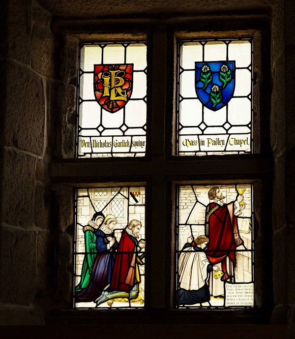
In 1888, the two Padley Martyrs, as they became known, were given the title ‘Venerable’ by the church – this means they have been declared a ‘servant of God‘, and that they had ‘heroic virtue‘ – essentially the recognition of one’s life work, as well as one’s death. This led to the creation of an annual pilgrimage to Padley Chapel – the converted former gatehouse of the now ruined Padley Hall.
Commemorative card and medal printed and minted following the 1888 declaration of the title ‘Venerable’.
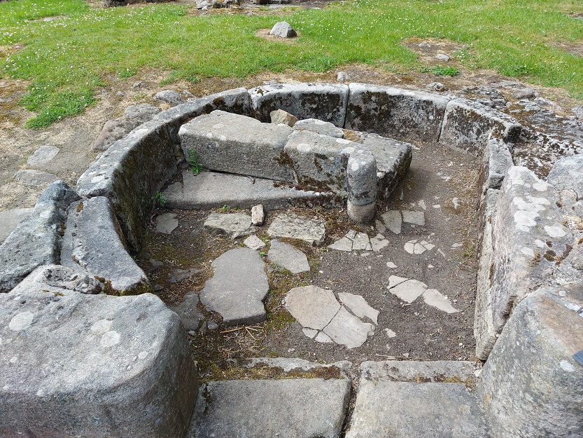
There would have been a private chapel in the hall, and it is suggested that this was in the upper part of the gatehouse. In 1934 the original 16th century altar stone was discovered buried in the garden where it had been hidden by the FitzHerberts prior to their arrest, and would have been the original one that Nichols would have used to celebrate Mass; it now forms the altar in the chapel there.
The altar at Padley Chapel, complete with original stone.
Then, on 22nd November 1987, Nicholas Garlick was Beatified by Pope John Paul II. This is a significant event, and is one of the necessary steps on the road to being declared a saint; if the Church confirms a miracle through his intercession, then he will officially be declared Saint Nicholas of Dinting. Whatever your personal beliefs, it is quite a journey from Dinting to the right hand of God.
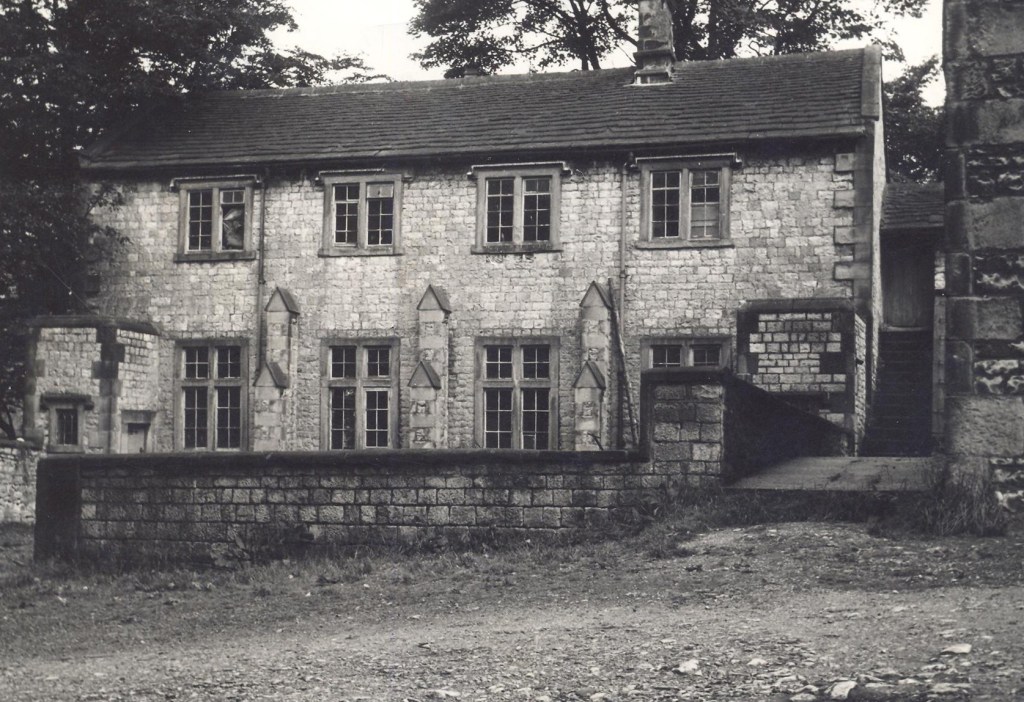
Family Hamnett recently visited the chapel and ruined hall – it’s remarkable what is still standing and can be seen, and it’s a wonderful romantic ruin, set in lovely walking country, and with an astonishing, if grim, history:
Padley Chapel, originally the gatehouse to Padley Hall. And a standing stone, too – probably a track marker rather than a prehistoric stone.
The north western range, containing the great hall. There are three doors in front of us – left into the great hall with the huge fireplace behind, right into an ante-room, and middle up a spiral staircase, the base of which can be seen. Look how worn the door steps are.
Close up of the spiral staircase base. Fanstastic!
Master Hamnett exploring the ruined fireplace. It’s huge!
There are lots of medieval tracery and carved bits lying around – some have been incorporated into a wall, but others can be seen.
I also found a Victorian John Smith’s of Tadcaster beer bottle in a wall, which was a nice bonus!
A photograph of a reconstruction of Padley Hall, shamelessly taken from the Time Travellers’ website – they seem to be a good bunch of archaeological types, so go check them out, especially if you live near Sheffield.
The whole place is amazing, and well worth a visit.
If you are interested in this period of history, I cannot recommend highly enough The Stripping Of The Altars by Eamon Duffy – it studies both the state of Catholic religion in England prior to the Reformation, as well as the sweeping and catastrophic changes that occur during and after. Have a look on Amazon, but please make sure you buy it at Bay Tree Books on High Street West in Glossop. An added bonus is that it might be me that sells it to you.
Another view of Nicholas Garlick. Here he is pictured holding a knife in the traditional style of portraying saints holding the method of their martyrdom. This one from the Lady Chapel of St Mary’s Church, Derby (via this website)
I hope you enjoyed this slightly longer than usual post, and unusual subject matter. More pottery next time. What do you mean, “no, please no, spare us the pottery“? I can hear you, you know. Honestly, the nerve of some people. More soon, but until then look after yourselves and each other, and as always, I remain.
What ho, kind and gentle folk of the blog reading world!
Sooooo, today is back to some sense of normality in that I am looking at pottery. “Woo-hoo!” I hear you cry. Well alright, some of you cried “woo-hoo!“. Well alright, not that many of you if I’m honest. Certainly not enough of you. Well tough… it’s my blog, and I like pottery, so we’re doing pottery. Now pay attention, I may ask questions.
Actually, this stuff is interesting in two ways. Firstly, as bits of archaeology. And secondly, I didn’t find them! No, that dubious honour rests with my friend and fellow delver and obsessive, Charles Winford Lodge (actually not his real name, but then you are reading a blog written by a man who has been dead for well over 100 years, so it’s probably best not to start asking too many questions at this point). He goes by @2hrTV on Twitter, and usually has something interesting to say on the subject of the history of Glossop and area. Usually… I mean, I can’t promise.
Anyway, the conversation – pretty normal for us – went along the lines of: Him – “Years ago I found some pottery at Valehouse Reservoir. I’ve just re-found it in the house… want to see it?“ Me – “Absolutely, my good man… lead on.”
Out it comes (in a plastic doughnut box from Tesco – price £1.10 – bear in mind this is the man who once gave me some pottery in a camembert box, so doughnuts are a step up). Most of them are fairly standard Victorian sherds, but one or two made me sit up. Now, the sherds had not been washed (tut! tut!), and so I volunteered to take them, clean them, and blog about them. Which is how I ended up washing up someone else’s broken old rubbish. Please, no one tell Mrs Hamnett… it might not end well. For any of us. However, I think the risk was worth it.
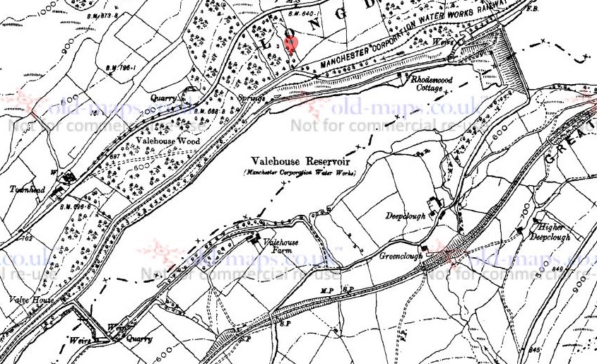
Valehouse is an interesting place; now just the name of a reservoir in the Longdendale Valley, below the Woodhead Road, it was once a village that in its prime, and prior to its flooding, had roughly 600 residents in 100 cottages with a number of shops, a school, and other amenities. Samuel Oldknow built the first mill here in 1775 – the first to harness the power of the Etherow – and it is after this point, and largely in the early 19th century, when the mills were substantially expanded, that the majority of houses were built to house the mill workers. The valley was flooded in 1869 to provide Manchester with water, and the mills and houses were all submerged. I also have a personal connection with the village in that my great great great grandfather, Benjamin Livesey, was born there in 1824.
Valehouse prior to the 1869 flooding. Note the large mill buildings, and the many houses.
Valehouse as it was in 1899, and indeed still. Note the large quantity of water and lack of houses.
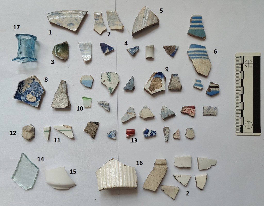
So then, the pottery. It was recovered during a drought a few years ago, and from the area around the viewing platform on the north side of the reservoir. Having studied the sherds, it’s clear they can be split into two broad chronological groups – early 18th century and late 19th century – which probably represent two different origins. I’ll discuss the latest first, before looking at the oldest, and arguably more interesting.
Not, at first glance, particularly inspiring.
1 – A Victorian earthenware jar or jug, vertical ridged decoration, with a body diameter of 9cm, and glazed in a lovely cobalt blue colour. Nothing special, but quite fancy.
2 – Simple sherd of blue and white earthenware, with the bog standard transfer print.
3 – Thick base to a Late Victorian Codd Bottle. It has ‘TON-U-LYNE’ embossed on one side, and a little research gives us ‘R.A. Barrett & Co.’ of Ashton-Under-Lyne. They manufactured soft drinks and mineral water, and were particularly noted for their ginger beer. Their factory still stands in Dean Street, Ashton.
A complete Barrett & Co. Codd bottle, and the factory as it stands today. The bottle fragment above would have been made in this factory.
4 – Fragment of bottle, probably Victorian mineral water or beer.
5 – Another fragment of green glass – probably Victorian, as it is quite thin walled, but it does contain large numbers of bubbles, suggesting perhaps an earlier date.
6 – A large, thick walled, earthenware sherd, perhaps part of a lid to a very large “Brown Betty” teapot – it is certainly the right colour for this, and curves the right way. The surface colour is a mottled brown, and is a type that deliberately recalls the earlier, 18th century, manganese ware. Interestingly, you can see how this effect is achieved by looking at the break. Two colours of clay – one dark reddish brown and one a creamy buff – are loosely mixed, and the clay is shaped into the mould. It is first fired, then a clear or slightly yellow glaze applied, followed by a second higher temperature firing. Where the cream buff forms the surface, it is a yellow or golden brown, and where the reddish clay forms the surface, it produces a dark rich brown, together forming the mottled effect. I quite like it, but much prefer the original 17th century stuff.
The appetising looking Victorian mottled ware sherd. You can see how the different coloured clay affects the surface colour
Right, let’s move onto the arguably more interesting stuff.
This material dates from roughly the early 18th century – let’s say 1700 – 1750… ish.
1 – Large and chunky strap handle probably of Nottingham Stoneware, and probably from a large jug or flagon. It measures 4.5cm wide, and is typical of its type. Stoneware is fired to a very high temperature, melting – or vitrifying – the clay, making it into a very hard and almost metallic pottery. It has a dark grey fabric, with a brown glazed surface which is very shiny – the result of adding iron to the glaze. Interestingly, this is not as fine or well made as the earliest material here, and shows some similarities with the later Derbyshire Stoneware, so it might be the somewhere in late 18th century.
2 – Base to a stoneware jug or jar, with a diameter of 10cm. This too has characteristics of both earlier Nottingham Stoneware and the later Derbyshire type – the glaze for example, is less lustrous than early sherds, but it has the classic grooved decoration running around the base. The underside shows wear suggestive of use and re-use over time. On balance, I’m going to say it is early, safe in the knowledge that no one is going to double check (as he scurries away and hides it).
3 – Lovely Nottingham Stoneware bowl, with a rim diameter of 13cm, and a slightly flaring out-turned rim. It’s thin walled, with a grey uniform fabric that was slipped in white before glazing. The surface glaze is a lovely melted chocolate colour, very lustrous and almost metallic looking, and is very characteristic, as is the horizontal grooved decoration on the exterior, and glaze drip marks on the interior. I liked this so much that a drew it using the archaeological method – essentially looking at the whole vessel in profile, and removing a quarter to allow both the interior and exterior to be shown.
The profile of the sherd is shown on the left, coloured in black – this shows the shape of the pot. The interior of the pot is shown next, with the wavy lines where the glaze dripped. Then the exterior of the vessel is shown next to that. I might do a post about this type of drawing, as I’d like to do more. It’s been a while since I did this last, though.
4 – This is a bit of an odd one. Stoneware, but potentially quite early. Certainly it fits with the 18th century stuff, but the surface is off – it looks like orange peel, dimpled all over with a salt glaze, and reminds me of the earlier 18th and even 17th century German stonewares that were imported in huge quantities. Whatever it is, it’s a huge rounded or pot bellied vessel with a diameter of roughly 26cm, despite being very thin walled. It is also a closed vessel, being glazed on the exterior only, so perhaps some form of small barrel or large bottle?
5 – Nottingham Stoneware – flask or bottle type. The body, shoulder, and beginning of the neck only, it has a body diameter of 18cm, so quite large despite being very thin walled. It has a double band of horizontal incised decoration which is showing the under slip where the glaze is thinnest. Like No.3, the glaze is lustrous and a melted chocolate in colour.
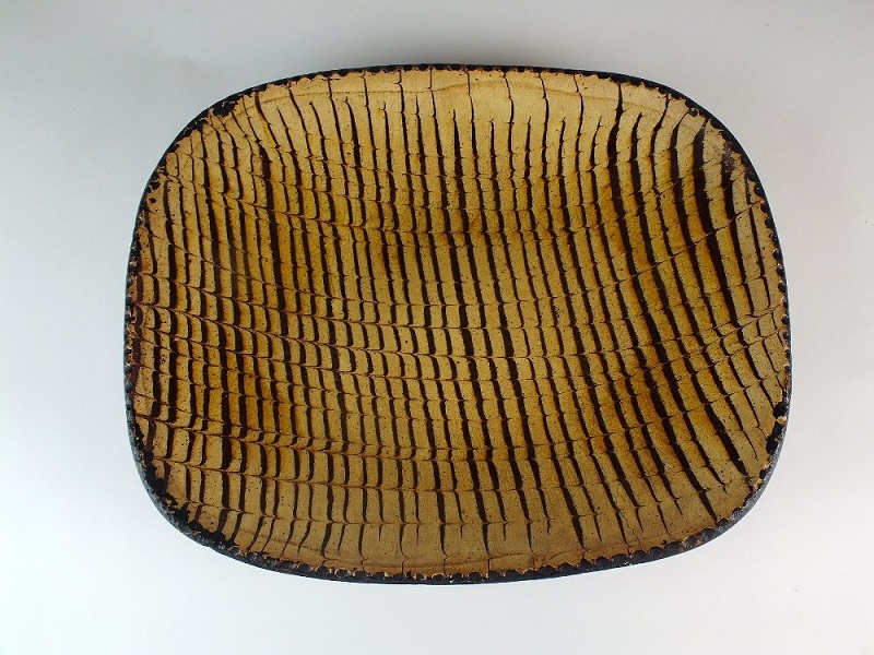
6. Finally, we have the star of the show – a rim fragment of a Staffordshire Slipware platter or large plate. This stuff is very diagnostic, and gives a clear date of between 1650 and 1750, with this sherd from 1700ish.
Interesting stuff!
Slipware like this is quite good quality, and a step up from the wood or plain wares that the average man or woman would eat from – or rather take from, as this would be a communal dish that everyone would eat from. Often broadly rectangular (as this is, I think), they are shallow, and would be completely covered in this linear banded decoration of yellow and dark brown. It’s quite striking, and would be a blast of colour in a world that was otherwise quite drab, particularly in winter. I still can’t work out whether I love or hate this stuff! Here is a complete example:
A complete example of migraine inducing 18th century pottery.
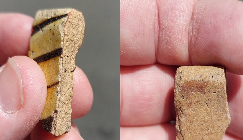
The process of decorating the pot went as follows: the pot is first moulded, then fired at a low temperature. The interior, and only the interior, is covered in a red slip, then overlaid with a white slip, and a tool is then dragged through this white slip, revealing the red underneath. The whole interior is then covered in a clear glaze and fired, transforming the colours to dark brown on the red, and honey yellow on the white. The whole process can be seen if we look at the break on the sherd:
Right – some of the red slip splashed on the exterior of the sherd, it remains red because it hasn’t reacted with the glaze. Left – all there elements can be seen in the break: the red and white slips, the tool that scraped away the white slip, and the glaze that overlays the lot.
So what does all this mean, then?
Because the valley was flooded to create Valehouse Reservoir, it gives us a cut off point (a terminus ante quem in archaeological terms – essentially the latest time an event could have happened) – any buildings and such there must have been built before this point. However, that is not strictly true with portable objects, especially those found near the edge of the water – the reservoir was almost immediately a picnic and pleasure spot, and plates get broken, bottles get launched into the water, etc. So we can suggest tentatively that although some of the material will likely be from the village before it was drowned, most of the Victorian material, and in particular the Codd Bottle, was deposited after the reservoir was filled.
The same cannot be said for the earlier material, and therefore there was clearly some form of settlement here prior to the Victorian period, as no one in their right mind is going to carry around 150 year old pottery to throw in a reservoir. Alright, I might… but most people don’t. So this material has to be from an 18th century dump of some form… but from where. Studying a map of Vale House prior to flooding shows clearly the mill complex and all the houses.
I love playing around with Microsoft Paint!
Circled in red is the rough location of where the pottery was found. But here, in the green triangle, is an odd looking group of buildings. Set apart and in its own land, it looks like the standard farming hamlet for this area, made up of the farm building, outbuildings, and farm worker’s cottages. And in Bagshaw’s Directory for Cheshire dated 1850, we read of Joseph Roe, Farmer, Vale House Farm. Even the name ‘Vale House’ suggests a house of some importance. I wonder if, as so often happens, the local big house or manor house became less important over time and ended up as simply Vale House Farm. If so, then this might explain the 17th – 18th century pottery, and given that it’s made up of several different domestic vessels, suggests strongly that this is the midden, or rubbish dump, associated with the farmhouse. All we have to do now is wait for another drought and we can see what else is buried there.
Valehouse Reservoir today. Somewhere in the middle of that photograph, below the water, lies the remains of a 17th century farmhouse.
Hope you enjoyed this weeks romp around with pottery… let me know what you think, anything at all, even to tell me I’m wrong about the stoneware base (I’m not… it’s my site, and therefore I’m always right!). Also, if you have any pottery that you want me to look at… just don’t tell Mrs Hamnett.
Next month, we have a very interesting tale to tell… more of that later. For now, take care of yourselves and others, and until then, I remain.
So, despite having half a dozen half-written posts, piles of interesting objects and sherds to talk about, and a few adventures to recount, I want to try something a little different today. “Oh no!” I hear you cry. But fret ye not, gentle reader, for it is still archaeology, it is still Glossop based, and it is still interesting. But it is a little… quirky. You’ll see what I mean.
I have a friend who is a writer, and quite a good one at that. He has often mentioned that stories usually start with what he terms a “What If?” moment, where something – often an object – presents itself, and the question is posed “what if…?” From there the story grows, based on and around that one question. The answer that comes doesn’t have to be ‘real’, it is fiction after all, but it has to be possible. What if a house was haunted? And what if the house fell down? And what if a brick from the house was haunted too? And what if a dashing archaeologist took the brick home to write about it on his extremely popular and incredibly interesting blog? What if…?
Archaeology, I think, uses a similar technique. An object is excavated, and the interpretation – the story – begins. However, where we differ from writers is that we base our ‘what ifs…?’ on evidence and supposition grounded in data. The interpretation, in this sense, has to be ‘real‘, although it is only ‘real’ for as long as the data supports it. Sometimes though, It’s fun to play “what if…?” – and here we join today’s post.
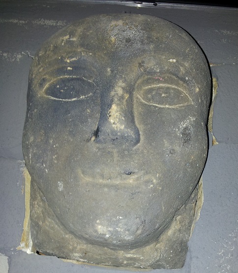
A stone head displaying all the characteristic features, including almond eyes. This one was allegedly found on Mouselow, and now lives on a wall in Buxton Museum
Stone heads. A lot has been written about them. They are cursed and evil. Or they are warm and friendly. They are ‘Celtic’ (i.e. Iron Age or Romano-British) in date. Or they are medieval or early modern in date. Or a combination of both. They represent an unbroken pre-Christian tradition, and an aspect of the whispered ‘Old Ways‘. Or they are simply folk art, and just decorative. Or they are magically protective (that wonderful word, apotropaic, again). Or both. Or neither. A brief trawl of the internet gives a lot of different sites and opinions, ranging from the scholarly and the more open minded, to what can only be termed outright nonsense.
Whatever they are, carved stone heads are a feature of this part of the Pennines – from Longdendale, over the hills to West Yorkshire, and up to the Calder Valley. I actually have a serious project that is looking at them; cataloguing known examples from Glossop and Longdendale, and trying to place them geographically, as well as giving some sort of date to them. There are at least 23 examples from the Glossop area, with more doubtless waiting to be uncovered. But it’s an ongoing project, and not really ready to publish – here, or anywhere else for that matter – and I just keep chipping away at it. It was during the course of trying to map where they were found, that I noticed something very interesting.
Stone head in Old Glossop. Image stolen shamelessly from the Old Glossop website (follow this link – the website is very good)
Before we go any further, I should state that my personal belief is that most of the stone heads are medieval or post-medieval in date (indeed, there is a record of them being carved in the 19th Century). That’s not to say that Iron Age ‘Celtic’ examples don’t exist (one was found at Binchester Roman Fort, in County Durham in 2013), it’s just that it is very difficult to date them as they usually don’t come from any secure archaeological context, and basing a date on ‘style’ or method of carving, as has happened in the past, is notoriously dodgy. That stated, there is the possibility that I might be wrong. And this led to my ‘what if…?‘ moment.
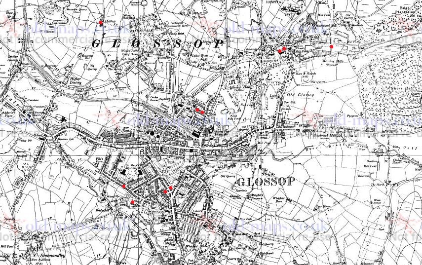
Back to the find location, sadly the majority of the heads are simply “found in Glossop area“, and thus have no exact place. But from various sources, I was able to identify where some of the heads were found. The distribution map is below:
1:10,000 map of Glossop. The Find spots – where the heads were found – are marked in red.
They seem to be dotted all around the area: Mouselow, Manor Park Road, several in Old Glossop, etc. However, looking at the above map, I noticed there was a distinct grouping in Whitfield – four of them centred around Slatelands Road and Hollin Cross Lane. Hmmmmm… let’s have a closer look, then.
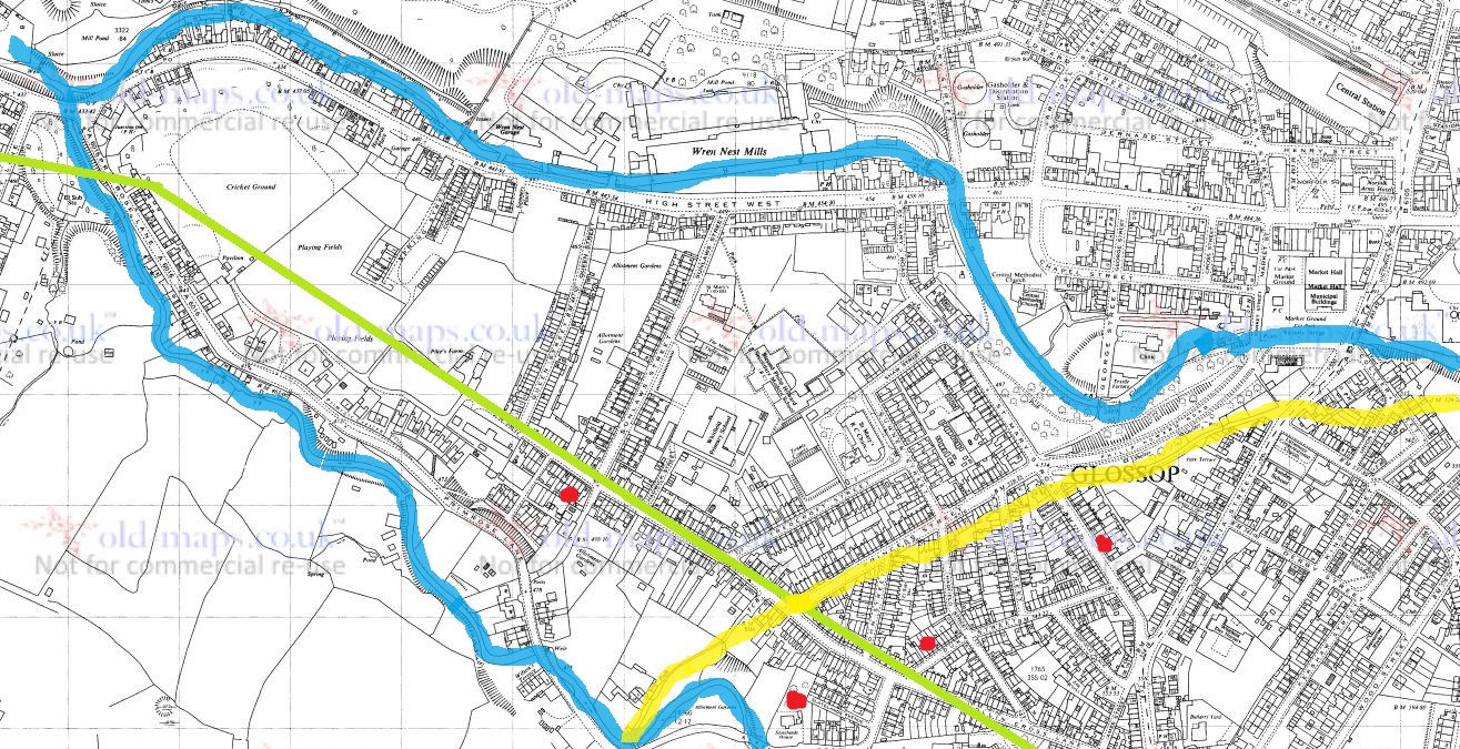
Here is the Whitfield group on the 1:2500 map.
Duke Street, Pikes Lane, St Mary’s Road, and Slatelands Road. Geographically, they are in the same tangle of roads in that area. But the heads more than likely pre-date the Victorian roads, so we need to strip them back. What was there then? Well fields, mainly, though the medieval track from Simmondley to Glossop ran through here (that blog post is coming, I promise!). And before that, the Roman road also ran through here, along Pikes Lane, before kinking over Long Clough Brook and onto the fort and settlement at Melandra.
And then, the “what if…?” hit me.
For the sake of a good story, what if these heads actually were Iron Age or Roman in date? What could this cluster mean?
Looking again at the area stripped of the Victorian houses, it’s very clearly a promontory, a high plateau that runs between two brooks – Glossop Brook to the north, and Long Clough Brook to the south. In the Iron Age, they liked their elevated places – Mouselow, which dominates the area, is a classic Iron Age hillfort, and others exist nearby, at Mellor and Mam Tor. One only has to look at St Mary’s Road from Harehills Park to see how steep those slopes are (try doing it pushing Master Hamnett in a pram with a load of shopping from Aldi). And on the other side, who hasn’t cursed Slatelands Road halfway up, gasping for breath. This is a very real landscape feature, completely masked by later development, but one which would have been very visible back then. This would have been particularly true where the peninsular narrows at the west, leading down to the junction of the two brooks. This too, is significant.
Throughout prehistory water was a sacred thing, and was considered ritually important. A spit of land, elevated, defined by water and ending in the confluence of two bodies of water, would have been hugely significant. Actually, a perfect place for an Iron Age temple or shrine, perhaps one devoted to the ‘Celtic head cult’ as suggested by scholars such as Dr Ann Ross (in her Pagan Celtic Britain)? Indeed, the North Derbyshire Archaeological Survey notes that the number of heads in the Glossop area “might suggest a cult centre” based in the town in the Romano-British period (Hart 1984:105). It has been suggested that the heads are sometimes associated with liminality and boundaries, and were protective. What if they were they placed facing down the peninsular, to mark out the sacred space, and to defend it?
The Roman road moves through this promontory, sticking to the high ground away from the valley floors and marshy terrain, as the Romans preferred (see map below). But what if the location of the possible shrine or temple influenced the choice of road location, ploughing through the sacred enclosure, perhaps to make a point about Roman dominance?
The location of the heads in relation to the landscape. The blue is the waters of Glossop Brook (north) and Long Clough Brook (south), forming the spit of land. The yellow line is the medieval trackway, and the green line is the course of the Roman road.
What if…?
Now, I’m not suggesting for a moment that that the above is absolutely true; this is a wild flight of fantasy, and pure fiction – a story. Indeed, doubts are being raised about the reality of the ‘Celtic head cult’ theory in general. But it is a possibility, at least: an archaeological what if…? However, if that isn’t the answer, there still remains the issue of why four stone heads were found in a cluster in this area. What is going on?
If we return to my original thought, that the heads are medieval or post-medieval in date, might they be related to the Simmondley – (Old) Glossop trackway in someway? If we look at the map above, we can see this track (marked in yellow) runs broadly along the line of Princess Street. And just to the east of the three of the heads run along the same alignment. Is this significant? What if people somehow, and for some reason, deposited these heads to the east of the track? But why? Well, I came across a possible reference to just such a practice in this area – Clarke states that “Oral tradition in the High Peak of Derbyshire suggests heads were buried as charms beneath newly-built roads, presumably to keep permanent watch over them” (1999:286). He cites no sources for this “oral tradition”, but this type of apotropaic function – preventing witchcraft and promoting good fortune – is associated with carved heads all over the United Kingdom (Billingsley 2016). Perhaps, then, we are seeing the ritual deposition of carved heads as part of the road building tradition.
What if…?
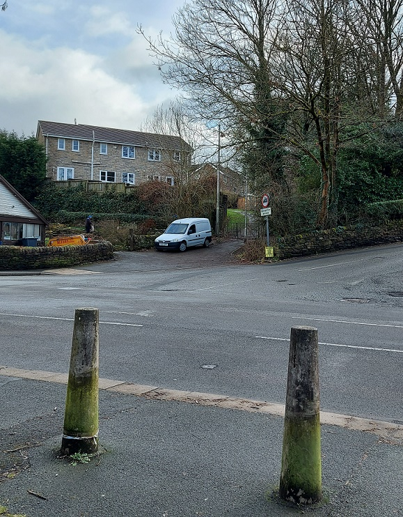
A pair of Whitfield Heads. These are at the end of Kershaw Street… and that is all I know about them. It’s on my ‘to do’ list, don’t worry.
No, it is a mystery, and ultimately we are left with questions for which there are no obvious answers. Three of the heads are in Manchester Museum, and the fourth presumably in the hands of the owner/finder. I will have to go and see them, as that might help in dating. As I say the project is ongoing, and any comments or help in the area would be greatly appreciated. Do you know of any stone heads? Do you have photographs of any? Or stories – they seem to attract folklore and superstition like nothing else! Please contact me in the usual way – email me, or through twitter ( @roberthamnett ). Or just come and find me in the street, as people are increasingly doing… so much for pseudonyms and anonymity!
I do hope you enjoyed the little flight of fantasy, but we’ll be back to business as usual next time – the sherds are mounting up! Until then, look after yourselves and each other.
And I remain, your humble servant
RH
References:
John Billingsley – Instances and Contexts of the Head Motif in Britain
David Clarke – The Head Cult: Tradition and Folklore Surrounding the Symbol of the Severed Human Head in the British Isles. (Unpublished PhD Thesis, accessed here)
Anne Ross – Pagan Celtic Britain: Studies in Iconography and Tradition
(well, it is here and now, but I suppose it depends on when you are reading this… in which case, feel free to substitute “evening” for whatever part of the day you happen to be reading this.)
Perhaps I should start again.
What ho!
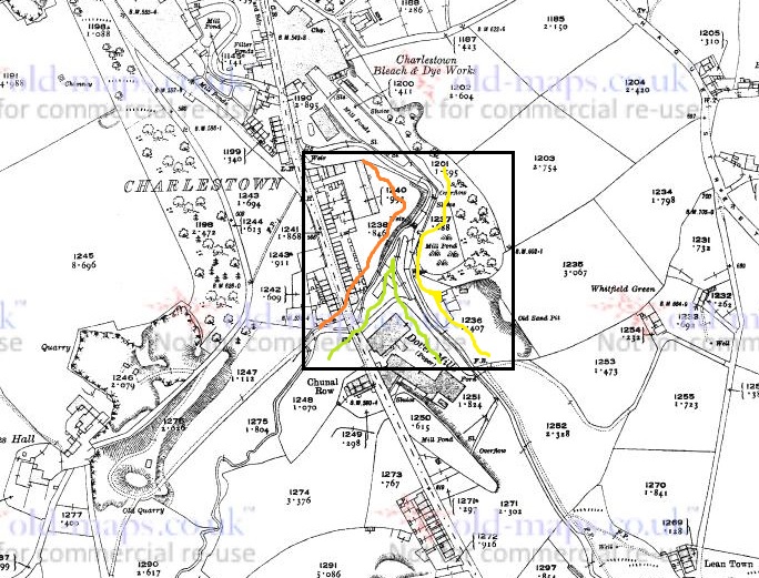
A short one today – I realise that I haven’t been as active as I’d like, so rather than labour over a larger post, and as a sort of proof that I’m still alive, I present today’s smaller offering – the area of Glossop known as Bridgefield. This is a place you drive through without ever noticing it is there – blink and you miss it as you go from Charlestown to Dinting along Primrose Lane. It is also a great example of why maps are so useful as a record of places – without it being drawn on the map, it is likely that Bridgefield would have ceased to be remembered as a place at all.
I have commented elsewhere that older names for places are usually based on reality, and reflect a different set of priorities – largely truthfulness in description: Gnat Hole was not named ironically, and so it is with Bridgefield, it was – and is – the field with the bridge. Well, actually bridges, plural – there are two. The first is where Primrose Lane crosses Long Clough Brook, circled in blue on the map below. But it is the second one – a small footbridge over the Long Clough Brook – that I think is the more interesting of the pair, and is indeed the older. Moreover, it actually is in the ‘Bridge Field’, rather than two fields over. And so, this humble little bridge is the target of today’s fevered ramblings. The bridge, or to be precise an earlier incarnation, is circled in green in the map below.
A rather colourful rendering. The bridge of Bridgefield is marked in green.
It crosses Long Clough Brook at the bottom of Slatelands Road, and now forms the bottom end of a footpath from Pikes Lane, emerging into Primrose Lane. This track – marked in red in the map above – wends its way between houses and land, and is known locally as the Chicken Run; indeed it still has chickens at the bottom. It was also known as the ‘Giggle Gaggle’, apparently, which recalls strongly the ‘Gibble Gabble’ in Broadbottom – another track that wends its way between houses and land. Indeed, it is suggested that Gibble Gabble (and thus Giggle Gaggle) is a localised (Mottram, Broadbottom, Glossop) dialect name for what is known elsewhere as a ‘ginnel’ (a track that wends its way between houses and land), which makes sense (here is a little more on the subject). According to A Journey Through Glossop by Kate Best and Owen Russell this same trackway was also known as Burneen by the nuns of the convent on Shaw Street, who used it to get to Hobroyd.Burneen is a version of the Irish term, Boreen, which means… anyone? Anyone? That’s right – a track, usually one that wends its way between houses, etc. There is a theme here… if only I could spot it. David Frith in his Pathwise in Glossop and Longdendale (p.60, Path 40) notes that this path went through allotments, and was known as the ‘Flagged Fields’, again strongly suggestive of a maintained trackway or road.
Joking aside this track is very important; I am convinced it forms part of the medieval road (such as it was) between Charlesworth, via Simmondley, to (Old) Glossop. The track goes along Old Lane in Simmondley (the name is a clue), down a sunken trackway that might indicate both age and heavy use, and emerges along another ‘fossilised’ footpath, preserving the original trackway ‘in stone’ – here, at the bottom of Simmondley New Road and Moorside Close:
The tail end of the track that comes from Charlesworth via Simmondley (Old Lane).
It continues along the footpath until it meets Pike’s Lane. This track will be the subject of a future blog post as it is a vital part of the history of the area, and well worth an explore, but for now let’s return to the bridge. Here it is, then, the current bridge of Bridgefield.
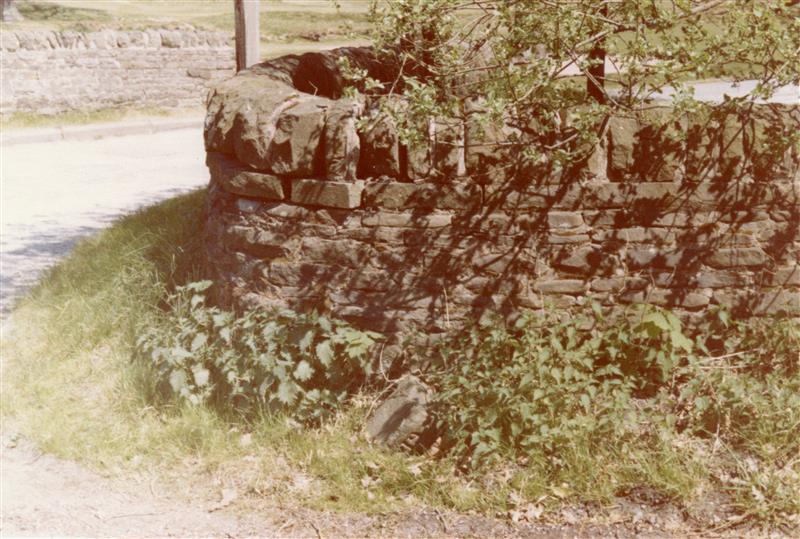
The bridge over the brook.
This bridge is quite modern, being made from rolled steel ‘I Beams‘, and it is clearly the latest in a long line of bridges of various sorts.
It works as a bridge, but it’s certainly not romantic.
We may assume that the earlier bridges were made from stone in one form or another, but looking into the brook, I noticed some large flat stones – much bigger and more substantial than paving slabs – that look out of place.
They’re not easy to make out, but the slabs are dotted along this stretch of Long Clough Brook, directly below the bridge. Incidentally, the Brook marks the border between Whitfield and Simmondley – as we look at the photo above, Simmmondley is on the right, Whitfield left.
Am I wrong to imagine that these once might have made up the medieval and early modern bridge in the form of a Clapper Bridge? The stones having fallen, but not moved very far by man or water.
A Clapper Bridge. This example is at Postbridge in Dartmoor, but they are a common way of forming a river crossing, especially where the banks are high – as they are at Bridgefield.
If I’m honest, I probably am wrong; the whole area has been extensively messed around with by the building of mills and mill ponds, as well as work on the brook itself with the building of weirs and shaping the banks. It’s difficult to get an idea what the area would have looked like, and it’s unlikely that any vestiges of the original bridge remain. But still, let’s imagine.
EDIT
Actually, further evidence to support the Clapper Bridge idea might be suggested by the fact that Slatelands Road, which runs down to the bridge, was once known as ‘Stoney Causey‘, the Stoney Causeway. The word ’causeway’ normally indicates a raised roadway across wet ground, as opposed to a bridge per se. which would fit quite nicely.
However, the importance that was once given to Bridgefield is underlined by the fact that the Reverend John Wesley, the founder of Methodism, preached here. Now, that Wesley preached in Glossop is not in itself big news – he preached all over, favouring the open air, and had a fondness for this part of England, returning time and again to spread the word of his particular brand of Christianity. But the fact that he chose Bridgefield as the location for the crowds of people that would have gathered – some jeering and making mock, others listening intently and converting – is significant. It indicates that this was an important place, and vital in communicating between towns – Glossop and Charlesworth/Simmondley, but also one that was well known enough that people all over Glossop would come and hear him. In his diary, Wesley records the following entry:
Friday, 27th March 1761 “I rode to Bridgefield, in the midst of the Derbyshire mountains, and cried to a large congregation, “If any man thirst, let him come unto me and drink.” And they did indeed drink in the word, as the thirsty earth the showers.”
Well there you go. Who knew that this often overlooked corner of Glossop had an interesting history. As I say, I’m going to blog about the Charlesworth to Glossop track in a future post as it’s a hugely important thing, and part of a larger project that is trying to identify all such trackways in the immediate area. I also recently did some mudlarking in Long Clough Brook, so should probably post the results.
Right, until next time, please take care of yourselves and each other.
What ho! A short one this time… well, relatively short. As I think I have mentioned previously, I normally have about 5 blog posts half written at any one time, and I pick away at them until one ends up finished. But how do I choose the subjects? Well, sometimes, they are obvious topics, and other times it is purely a coincidence, and fate picks it for me. Occasionally my own research throws up something that I think you, gentle readers, might be interested in. And then sometimes, as is the case with today’s entry, the subject simply throws itself at me and the blog almost writes itself.
As I think I have also mentioned previously, mine is not what you would describe as a normal life; I live and breath the stuff of this blog… to the point of obsession. But thankfully I am blessed with a wonderful and understanding wife (or ‘carer’ as she terms it, which is a bit off), and also a child who thinks growing up in a house filled with bits of pottery and odd bits of old tat is perfectly normal. But even I had a slightly discombobulating moment last week – the archaeological equivalent of the alcoholic hitting the fabled ‘rock bottom’.
“Oh no!” I hear you cry. But worry not, I’m not quitting… (and I’ll have another glass of red whilst you’re at it). No, this one was a case of opening my front door and being forced to confront an uncomfortable truth: it turns out I have now reached a point in my odd life whereby people leave bits of old pottery and other stuff in my garden, without so much as a by your leave. Clearly “it’s old and knackered, so give it to RH” is now a thing.
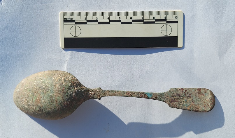
For there on my front wall, wonderful readers, was a spoon. An old spoon, granted, but a spoon nonetheless. “What ho!” said I, and leapt forward.
A random spoon on my wall. Yup… my life is totally normal.
Now the sight of such might have caused a lesser man to quiver and fall, but I’ve been around spoons before – I’m no mere amateur when it comes to them. Indeed, it’s certainly no idle boast when I say “I know spoons”.
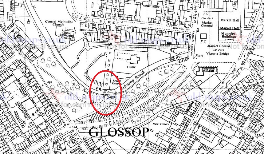
But from whence did said spoon come? The physical location of Hamnett Towers suggested only a few possibilities, and not knowing Uri Geller, my suspicion fell immediately on our clearly insane neighbours Helen and Sarah who, when not camping in their garden (mere metres away from a perfectly good house) or self harming by cycling to Tideswell and back, are amazing.
Turns out I was right! Sarah had found it in a wall in Whitfield, somewhere near the Beehive, and thought, correctly as it turns out, “good old RH might want that”. I looked closer, and my interest – already piqued – began to tingle. Writing… and possible decoration. The spoon was a welcome gift, but jokingly came with one condition, that I write a blog post about it. Well, here we are! Let’s look closer…
A spoon, yesterday. Honestly, it looks like Uri Geller has been here.
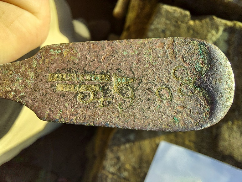
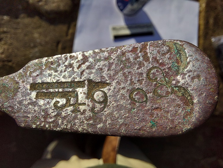
A close up – you can just about make out lettering and what looks like decoration.
The spoon is of a soup rather than serving type, and vaguely Victorian in shape. It was also very worn and covered in greenish verdigris – I really do get the best presents. I couldn’t read what it said where the maker’s mark normally is, nor make out the decoration so I took some very fine sandpaper to it, and removed what I could.
It becomes slightly more clear.And even clearer.
You can just make out the lettering – if you squint, and use the eye of faith – that reads “Walker and Hall. Sheffield” and a pennant/flag logo containing the letters “W&H“. And, over that a series of numbers stamped roughly onto the surface.
Walker and Hall were a company of silversmiths based in Sheffield. They were founded in 1845, but began operating with that name from 1853 onwards, and continued until 1920. This website suggests that the pennant logo should be dated between the late 19th century (say 1880) and World War 1 – which looks about right from the style of the spoon. Sadly, it’s not silver, but silver plated, and seemingly carries no mark, in which case it might date to before 1884 when Walker and Hall started putting marks on their cutlery.
As for the numbers, I have no idea what they might mean. I can make out “5, 4, 9, 9, 3, 2” Conceivably they could be the model number for the spoon type – there are examples of this being done – but these are very large and untidy, and seem to have been stamped in a haphazard way, with no easy way of reading them. Perhaps they were done by the owner as a way of identifying the spoon, but this leads to the question “why?”. The only explanation that I can come up with is that it was a ‘communal’ spoon, perhaps one connected with a pub or similar – the idea being it can’t be stolen because it is very easily identified. This fits nicely with where it was found, near the Beehive pub. It also fits with the wear pattern, too; it has been bent and straightened several times, as public cutlery often is, but also the huge amount of wear on the bowl.
The asymmetrical wear pattern at the tip
This wear is very visible at the left hand tip, meaning it was used by a right handed person or people. I would argue that a personal spoon wouldn’t worn that much if it was used for at most a meal a day. However, at a busy pub serving good mutton stew, that spoon might be scraped around a bowl 20 times or more a day. Do we have an original Beehive spoon? Well, I’m almost convinced.
Why it was placed in a wall is, frankly, a mystery. People do strange things with objects that are deemed ‘public’ (I look sheepishly in the direction of a wine glass that mysteriously ended up in my house, but which originated in a certain drinking establishment in a certain town), but it may well be that the spoon was too knackered and was simply thrown away, ending up in the wall via child or bored adult.
So there we are – a spoon! From a wall, to my wall, via my neighbours, and finally to you.
Right, that’s all for now. More coming soon, including the much talked about roads and tracks post that I keep promising. In the meantime, I’m going to put a box outside – if anyone else has anything old they want to give me, pop it in as you pass… who knows what I could find in it.
Until next time take care of yourselves and each other. And I remain
Blimey! January flew by, and so did February. Apologies for the lack of activity on the blog of late, I’ll be back to more regular posting from now on. What ho! Well here we are, once more in lockdown. I know its for the greater good, and you’d be a fool – and indeed a dangerous moron – not to follow the rules… but dash it all, it’s starting to be a bit of a bore! Right, once more with a glass of the stuff that cheers here we go.
Whilst perusing the local history section of the library – during the heady days when such a thing was possible – I came upon an architectural drawing of the bridge over Glossop Brook at the end of George Street – officially known as ‘Coronation Bridge’. Now, those of you that know the bridge will also know that it isn’t the most lovely bridge in the world – it’s hidden away in the dark damp recesses of Harehills Park, covered in graffiti, and surrounded by the waste ground.
The location of the bridge is circled
But let’s look again, I say, as I think there is a hidden beauty here – a ‘rough diamond’ of sorts, only made of reinforced concrete. First, here is the architectural drawing:
It’s a very Art Deco style drawing, and quite fetching.
And here is the bridge as it is now:
Not the most attractive looking bridge, but I think it has a certain charm.
Comparing the plan with the actual bridge, they really did a good job. It is an understatement to say that I dislike concrete, but this has a certain Art Deco feel about it, and I honestly think it would look pretty good scrubbed up.
It is fairly forlorn, and could really do with a scrub up. I like to imagine that the historical spirit of a place affects modern perceptions through things like graffiti: the foundry that once stood here would have been an extremely hot work environment – Hell Fire indeed.Concrete, close up. I particularly like the pink Mickey Mouse graffiti. What? It must be Mickey Mouse… look at the size of those ears.
The architectural drawing is dated 1928, so we might assume that it was built soon after that to replace the original Coronation Bridge, a railway footbridge that was presented to the town by Lord Howard in 1902 to celebrate the coronation of Edward VII. That bridge, notes the original Robert Hamnett, replaced other bridges that had been washed away numerous times by flooding. Now, far be it for me to question the original Mr Hamnett’s facts, but I can see no trace of these bridges on any of the earlier maps. For example, here is the area in 1880:
1880 1:500 scale. George Street is top centre, and you can see Shepley Mill and the George Street foundry.
Is it possible that he made a mistake?
Harehills Park is interesting in itself – I won’t go into too much detail, as the Glossop Heritage Trust has an excellent article on its history which you can read here. It has been known variously as Harehills Wood, Harehills, the People’s Park, the Sandhole, and Pinch Belly Park. These last two names are derived from the fact that during the ‘Cotton Famine‘ of the early 1860’s – a situation caused by the lack of imported cotton from America due to the ongoing Civil War there – men were employed there digging sand in order to provide work for them. In 1921 the park was given to the people of Glossop by Lord Howard in appreciation of the men of Glossop who served in the First World War, but also as a memorial to his son Philip Fitzalan Howard, a lieutenant in the Welsh Guards who died of wounds in France on 24th May 1918. The park was extensively remodelled and landscaped at this time, including the construction of the bridge, and was used as a recreation grounds and promenading area. Prior to this, the area was described as “hideously ugly; hen pens fenced with old fish boxes; old salmon tins, rhubarb roots, and a good quantity of other rubbish with plenty of muck and sludge thrown in”, and was known as a place for bare-knuckle prize fighting. It was also noted that “one part of it seemed to be nothing more than a vast tipping place”, and it is this part, one assumes, that keeps producing pottery. It has a been a particularly fruitful site to find pottery, to be honest – none of it too old, but its always there.
Prior to washing.
One assumes that the pottery has not travelled very far from the place of use, and so we might suggest that much of this rubbish came from the houses on St Mary’s Road, allowing us a peak into the lives of those living there. A more systematic approach and proper archaeological investigation could tell us a great deal – this is essentially what we, as archaeologists, do with pottery. Anyway, the sherds:
Fairly standard Late Victorian and Edwardian stuff, all from Harehills Park.
I’m not going to lie – a lot of it is pretty dull stuff, but there are some interesting bits and pieces, and this is a slice of domestic life in the Victorian and Edwardian periods.
Plate or soup bow1 with an undulating rim of c.20cm, and a poor quality light blue transfer printed pattern – the transfer doesn’t match up at the join. Mid/Late Victorian
5 plain white rim sherds of 14, 8, 18, 16 and 16cm. Saucers, plates and cups. Victorian – 1920’s
Fragment of a green glazed Majolica vessel, possibly vegetable-based. Utterly grotesque!
Tiny fragment of a Sponge Ware decorated vessel. A rare occasion where I don’t know the shape – it has a carination in the body, so possibly an early mug or teacup. Victorian.
Stone ware vessel, possibly a badly glazed marmalade pot – it has the grooves, but the surface is poor quality. C. 12cm diameter, so probably.
4 sherds of Annular Ware, Early to Late Victorian. This stuff starts much earlier than you expect (1780’s) and it looks almost modern.
2 sherds of a teacup rim, c.7cm rim diameter, and transfer printed on interior and exterior. Victorian.
Base to a transfer printed willow pattern plate. Base diameter is 10cm, so the plate would be at least 10cm. The print shows a pagoda in the standard willow pattern style. Victorian.
Rim sherds of 2 different Feather Edge bowls. Both date to between 1840 and 1890.
A tiny fragment of green and white art glass bowl or cup, with an undulating rim. I quite like this.
A saucer rim with a single green line below the edge. Refined, and quite nice. 12cm diameter.
Handle to a whiteware cup. Quite fancy, and possibly Early Victorian. Or possibly not… this stuff is difficult to date properly.
Red glazed rim to a jug or similar. Victorian.
Flat glass shard with vertical (horizontal) grooves in, slight greenish tinge. Possibly the lens to a torch or car headlamp.
Base and body of a porcelain teacup c.8cm in diameter, straight sided, 1920’s.
Base and rim to 2 marmalade jars – base is 10cm diameter, rim is 11cm, Victorian to Edwardian.
A beautifully coloured pale cobalt glass bottle. This is probably from a medicine bottle, and has what is called an ‘applied lip’, which means that the rim was made separately, and then melted onto the blown glass body. This is an inelegant solution to the problem of removing a blown glass bottle from the tube and leave a proper opening, and you can see the two parts twisted and melted together on the bit between the neck and shoulder in the next photo. You can read more about bottle finishings here:
Artful shot… shot, artfully.
What is also nice is that 3 sherds have maker’s marks on the bottom, allowing attribution and dates.
It’s not often I find maker’s marks. Nice.
Top sherd is marked either ‘Stone China’ or ‘Ironstone China’ which is a type of pottery that contains crushed feldspar in order to make it very strong and hardwearing. It was developed from about 1800 onwards, and this sherd is probably mid-Victorian. Bottom left is ‘Tuscan China’ made by RH and SL Plant at the Tuscan Works, Staffordshire. The logo dates it to the 1920’s and 1930’s, and was presumably broken and thrown away anytime after that, although presumably before the landscaping of the park. The bottom right is marked ‘Melba Bone China – Guaranteed Made In England’, and was made by Mayer and Sherratt, based in Longton, Staffordshire, and who operated between 1906 and 1941. So there you go.
Do have a look at the bridge the next time you go over or near it, as I think it deserves a closer look than it currently gets, and I hope that in the near future more is made of the area. Until then, look for pottery in the soil around the bridge, and think about mudlarking the bank of Glossop Brook there – I’m sure you’ll find something, but make sure you let me know what.
That’s all for this time. Apologies again for the lack of activity – real life has an annoying way of getting in the way of what you really want to do, but I will be posting more frequently… promise. Also, please do get in contact, for what ever reason, and follow me on Twitter too – I am quite active there. I am also working on a YouTube channel, where I can put videos of walks, mudlarking, digging, history bits, finds, and other shenanigans – it’s in the early stages, but I think it could be fun, but also a way of getting you all involved. Anyway, more soon, but in the meantime please take care of yourselves and each other – even just a cheery smile at your neighbour can make all the difference in these troublesome times. Until the next time I remain.
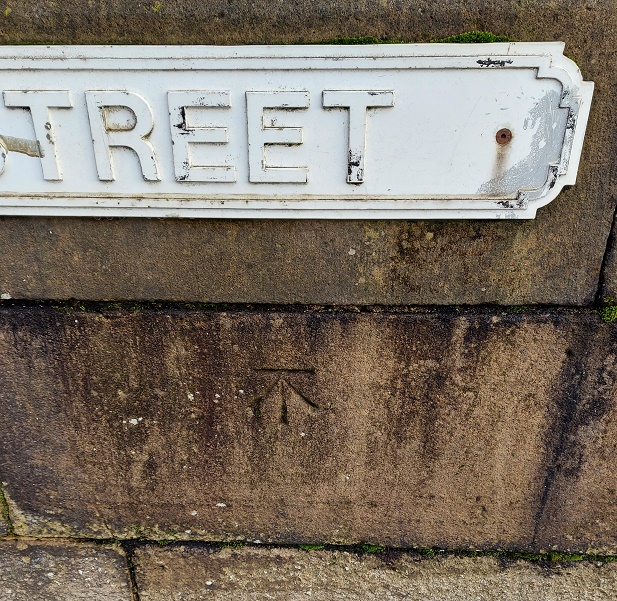
Ho! Ho! And if I might dare, What Ho! A shortish one today, and actually one that is something of a relief, if I’m honest. Like the last post, this one has been years in the making, but this time for all the wrong reasons… all will become clear in a moment, but for now let’s crack on.
As the title suggests boundaries are today’s topic, apt as we hurtle to the Winter Solstice and the shortest day – that anciently observed boundary between the old year and the new. Boundaries such as these are often held to be dangerous places as they are a liminal space – neither one thing nor another, but somewhere in between. However, boundary stones in particular I find fascinating and strangely appealing objects; there is something very grounding about them in that they mark in a clear, permanent, and fixed way, an imaginary line. On one side ‘X’ and on the other ‘Y’, and there is no argument – the somewhat liminal boundary is made visible and real, and so it is the case with our stones today – three stones placed on bridges over various waterways delineating the townships that make up Glossop
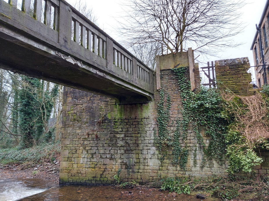
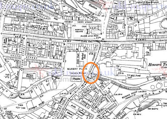
All three, it seems, were carved and installed at the same time, and all are quite old – early Victorian. The first of the stones is the easiest found – Victoria Bridge in the centre of Glossop.
Station at the top, above the High Street crossroads. The bridge over Glossop Brook, and the stone, is circled in orange. Glossop is north of the Brook, Whitfield is south.
And here it is in real life.
Victoria Bridge. Wetherspoons is in the background, and Glossop Brook runs beneath.
The bridge, and the stone, stand over Glossop Brook, which disappears under the market place and carpark, and the line carved between the words Glossop and Whitfield is the centre line of the brook below. Victoria Bridge was built in 1837, the year Queen Victoria ascended the throne, hence the name. This new bridge replaced an old and narrow hump-backed pack-saddle one. Indeed, the original line of the road that led over the bridge, down Smithy Fold, and along Ellison Street is traceable, and is preserved particularly in the buildings of the Brook Tavern, Cafeteria, Glossop Pizza, Balti Palace (all built in 1832). I have a blog post almost finished that looks at this area in more detail, so I won’t go into it here.
Looking closely, the inscription “Victoria Bridge” and the date “1837” are in a different font and slightly larger than the other lettering on the stone, and are more cramped, and it seems they were added at a later date. Indeed, compare this stone to the one below, and you can see they both once looked the same.
And of course, it wouldn’t be the Glossop Cabinet of Curiosities without a bench mark, this one on the bridge and just to the left of the boundary stone.
This is what 495.7 ft above sea level looks like.
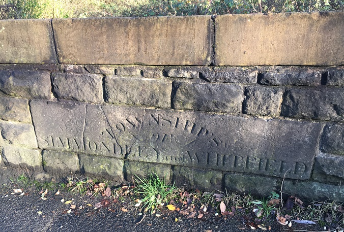
The next stone is to be found on Charlestown Road, on a bridge over Long Clough Brook – it’s very much a blink and you’ll miss it kind of affair, even if you are walking.
Turnlee and Charlestown Roads join at the top, with the boundary stone circled in orange.Here is the bridge over Long Clough Brook on Charlestown Road. The stone is visible.Here it is in close-up. Can you spot a mistake?
This stone follows the same formula as the Victoria Bridge stone, but is slightly rougher in execution. It seems to have been reset into a rebuilt stone wall at some stage, as it doesn’t really match the coarse surface of the stone around it, and this resetting might explain the cracking. It also has an inexcusable mistake… there’s a bloody apostrophe after ‘township’! It should read ‘TOWNSHIPS’, the plural of township, but instead it reads that ‘Township’ owns something called an ‘of Simmondley and Whitfield’! Also, although it states that this is the boundary between Simmondley and Whitfield, it technically isn’t. This is the border between Chunal and Simmondley, but it seems that for administrative purposes, Chunal and Whitfield were often lumped together. The confluence of Bray Clough (from Gnat Hole) and Long Clough Brook (just east of the boundary bridge) is actually the meeting of the three townships of Chunal, Simmondley, and Whitfield, here:
The three townships illustrated at the junction of Bray Clough Brook and Long Clough Brook. Chunal in green, Simmondley in red, and Whitfield in yellow.
So far, so good.
Now, the third and final stone was a bit more of a mystery. According to Neville Sharp (Glossop Remembered p.184 – a great book, by the way, well worth seeking out – here for example, but order it from Bay Tree Books on the High Street, of course), a stone similar to the one on Victoria Bridge stood on the bridge over Hurst Brook which forms the north eastern boundary between Glossop and Whitfield. That is until it was washed away in a flash flood.
High Street East at the top, with Derbyshire Level running from the Royal Oak off the map at the bottom. The word stone on the bridge over Hurst Brook is circled.
Then, whilst doing some research, I came across a reference to the stone and made a note in my notebook that until at least 1977 the stone stood next to the entrance to Golf Course. Annoyingly, I didn’t take down the reference and it’s taken me 3 years to track down the source of the information. Three years! Such is the level of detail and dedication I devote to this blog in order that you, gentle reader, can revel in such a fascinating subject as “bits of old plate” as it was once described by the person who runs the ‘Official Glossop‘ twitter account. Honestly, the nerve of some people…
So I re-found the source – this website – and blow me if it didn’t have a link to photographs of the stone taken in 1977:
Entrance to the golf course on Derbyshire Level, the boundary stone bottom centre, in the glorious sunshine of the summer of 1977
Close up of the boundary stone with part of the word ‘Glossop’ visible. Please note that I don’t have the copyright to these photographs, and make no claim to such, they are merely ‘borrowed’ from the above site.
The stone was presumably recovered, in its broken state, and set up on the side of the Golf Club entrance, and whilst it doesn’t look like there is a lot left I went to have a look.
The same view as the first photograph above, missing the important piece.
Alas… the stone is no longer there. I had a good look around at all the stones that might be a possibility, but to no avail. I suspect that someone has taken it – it was a nice piece of stone after all, but it is a shame. All is not negative, though, and from the 1977 photograph we might suggest where it originally stood; the fact that the fragmentary word ‘Glossop’ is visible at the left hand end of the stone means that it could only have stood at the eastern side of the bridge, closest the golf course, for it to make geographic sense – Glossop is north, Whitfield is south at this point. Here, in fact:
Here. You can see the modern(ish) bridge that must have replaced the one that was washed away. Here, Hurst Brook separates Whitfield (right) from Glossop (left).
Its fragmentary nature also suggests that more of it lies in the stream bed – I had a look, but couldn’t see any likely stones, but perhaps next summer I’ll have a poke around.
Right ho, that’s all for this time. Hope you enjoyed a ramble around the boundaries, and in fact I am writing a blog post that actually covers the boundaries of medieval Glossopdale based on a 13th century perambulation. I’d also like to do another that looks at the boundaries of all 10 townships of Glossop as they are in the Domesday Book, which could be a bit of fun. ‘Could‘ being the operative word here. And ‘fun‘ being an entirely subjective concept, I realise. But you, kind and gentle people, know what I mean… after all, you’re reading this. Please drop me any thoughts or hints, even to point out my mistakes, or the fact that I need a haircut. Take care of yourselves and each other, have a very merry Christmas, and until next time, I remain.
Welcome, welcome, one and all. I hope you are all well, and that in these uncertain times you are staying safe as we stumble towards something approaching real life. Today’s post does something I try not to do very often: it strays from Glossopdale and Longdendale. Don’t panic however, we’re still in Derbyshire. Marple Bridge to be specific. And there may be a link to Mottram, so there’s that. And quite frankly this story is just too good to miss.
I was looking through some online sources a while back, specifically the ones posted on the North West Derbyshire Sources website. There’s all kinds of interesting primary historical sources published there – censuses, trade catalogues, personal recollections, etc. and all of them are for this area – Glossop, Charlesworth, Hadfield, Hayfield – it’s well worth checking out, a truly award-winning website. One of the sources for Charlesworth is the diary of a certain George Booth, dated between 1832 and 1834. The diary is not perhaps what you would describe as the most riveting record of life in a small village; typical entries are very short, personal, and along the lines of “Today and yesterday I have been building a wall as a spur against the weir” (April 11th 1832) and “Daniel Thorneley’s wife died today” (April 28 1832), but these are recorded history, and for this it is invaluable. Certainly, the wall against the weir isn’t important in the grand scheme of history, but it provides us with the date and a personal record of who built it, and why – and these are surely the aims of all historical and archaeological inquiry? And it is these little snapshots – who built what wall, who moved house where, crimes committed, the price of pork, and tales of fire, flood, and cholera – that escape the archaeological record, making the diary an invaluable source. Here, read it for yourself, you won’t regret it.
And of course, although it is Charlesworth/Chisworth based, Mr Booth wanders all over the area, to Glossop, Gamesley, Chinley, Marple Bridge, Broadbottom, and beyond. It was one of these entries that caught my eye:
3rd May 1832
A Stone to commemorate Matlock’s Leap was fastened in the wall by the river side a little above Marple Bridge on the Derbyshire side, on this occasion there was a Mare [Mayor] chosen (I suppose the first Mare there ever was at Marple Bridge of this sort) and a regular Mare’s Walk consisting of the Mare (John Kirk) and a great many of the neighbouring Gentlemen after the walk the partook of a good Dinner at one of the Inns. which was paid for out of a subscription raised for that purpose this took place last Easter Monday.
So what was Matlock’s Leap? And why was it so important that it required a stone and a slap up meal to celebrate it, and particularly on a bank holiday Easter Monday (it would have been held on 23rd April 1832), and at the same time as choosing a mayor? Clearly it was so familiar to George Booth that it required no further explanation – it is almost a throwaway comment. And yet, the phrase “Matlock’s Leap” typed into Google provides just one relevant hit. It turns out that whilst the mystery was relatively easily solved, it is nonetheless quite a tale, and there may be yet more to be uncovered.
The single reference to the ‘leap’ is in ‘Cheshire Notes and Queries‘. This Victorian weekly periodical allowed readers to post questions of a historical or literary nature, and others to answer these questions, or to post some historical research they had undertaken. They are an absolute mine of folklore, history, archaeology, gossip, rumour, and all round fascinating stuff, and the Cheshire version is published online by the archive.org project – you can read it by following the link above (alas, the ‘Derbyshire and Nottinghamshire’ volumes have not yet been digitised). Here’s what was printed:
30th March 1889
About fifty years ago I recollect seeing a tablet in the wall, about twenty yards from the bridge, on the Derbyshire side, with the words Matlock’s Leap, and I think the date was upon it. I recollect being told at the time that it had been placed there by the landlord, Mr James Boulton, who, at that time kept the Norfolk Arms Inn, to commemorate a miraculous escape that a man named Matlock had one dark night. This man was in the Norfolk Arms, and he was suspected of having committed some depredation, and he was told the constable was at hand, when he immediately ran out of the house, ran across the road, and jumped over the wall down into the river, which I should think is here about forty feet perpendicular. I was told the man was not hurt. His friends got a ladder and got him up again all right. I have noticed that the tablet referred to has been removed from the wall where it was fixed. I shall be glad if any of your readers can tell me why and where it has gone.
Ashton-under-Lyne. I. W. B.
Now this was interesting.
Firstly, Matlock’s Leap was a thing… which is a relief. So Matlock was a person, and the leap was one over a wall and 40ft into the river Goyt… and he lived. Blimey! But also here is a wealth of detail. The tablet commemorating the event had evidently disappeared by 1889, but at least we know where it was – about here, to be exact:
About 20 yards down from the Norfolk Arms. No sign of the “stone” or “tablet”, alas.
I looked, and could see no sign of where the stone would have been fixed, and looking along, it seems to me that the whole of the wall has been replaced at some stage post-1832 – it looks Victorian, rather than Georgian, and it may have been then that the stone was removed.
The wonderful Norfolk Arms.The view of the Norfolk Arms from the place where Matlock jumped into the Goyt.This photo, taken from the bridge, shows the place where the leap took place – roughly 20 yards from the Norfolk Arms – is just about where the kink in the wall is. That’s 40ft if it’s an inch. I am certain, though, that the wall has been rebuilt since the 1830’s, and it may be that the riverbed has altered. Even so, that’s a hell of a jump!The same stretch of the river viewed directly down from the bank. Here is where Matlock landed in the river. I would love to doubt this, but all the evidence points to it being a real event.
Presumably, given the Norfolk Arms was the location of the leap, and that the landlord had put the tablet up, the pub was also the location of the slap up meal mentioned by George Booth. I was also intrigued by the ‘depredation‘ of which Matlock was accused.
DEPREDATION. noun. The act or an instance of plundering; robbery; pillage
That’s an oddly specific word… what did he do?
Two weeks after the above query was published, a comprehensive answer was given, one which reveals the whole story – it’s easier to reproduce the whole thing:
13th April 1889
MATLOCK’S LEAP.
In reply to your correspondent who asks about Matlock’s Leap, I may say that I do not profess to give anything I know personally, but I recently accidentally met a friend who lived at Marple when a youth, now he is over 70 years of age, and he told me a few matters he remembers about it. His first recollection of Matlock was before the “leap” had taken place, but he had often heard of “burkers,” “body snatchers,” and “resurrection men,” and was no little alarmed when he was told that these men stole dead bodies from churchyards for the doctors, and that the doctors made physic out of them which caused physic to taste “so bad.” One day, quite 60 years ago, my friend went to the Horse Shoe Inn for his father, who was indulging rather unduly to the neglect of his business. When he got there he found his parent in conversation with a man, and the father wishing to let the lad know who he was, contrived to whisper to him, and said, “that is Matlock; he is a burker, fetches dead people out of church yards at nights.” This was so strongly impressed on his youthful mind that he remembers it yet quite distinctly.
With regard to the stone that formerly marked the place of Matlock’s leap, my friend informed me that a present alderman of Stockport told him on one day that he last saw it in Compstall Gardens when they were kept by Mr Calab Warhurst.
The wide-awake “burker” had received a commission from a local practitioner, who, to tell the truth, was a most successful doctor, to supply him with a subject to operate on. And one night when the doctor was very busy in his surgery with patients, in walked Matlock with a bag on his back. The wily doctor did not wish to enter into any conversation or explanation with the “burker,” or seem negligent with his patients by leaving them to attend to him, so he simply gave him a well understood motion to go on through the surgery, which he did, and shortly returned, the doctor giving him five shillings, with which instalment he left the place. But, lo! when the doctor went to examine his bargain, he found that his hitherto trusty agent had hoaxed him, for instead of a corpse the bag was filled with lumber. So much my informant can vouch for, to which rumour adds – and, with a knowing nod, my friend says it was so – that the doctor was not only very clever in his medical profession, but also of much more robust build, and more capable of self-defence than was his tricky agent; and that when he next met with the ”burker” he give him a sufficient fisticuff chastisement. After this reconciliation and better understanding was entered into between then, and their friendship and business engagements were resumed from time to time as it suited their various purposes.
A short account that I have had from another source about the immediate cause of the leap, may be of interest to some of your readers. On the day I read your last issue and saw the account of Matlock’s leap, I met with a person who resides not far from the place, so, in a jocular manner, I said to him, “Do you know anything about Matlock’s leap and the resurrectioning case?” He replied “Yes,” and added, “and you will be surprised when I tell you whose body it was. Then he told me that the grave had been watched fop seven nights for fear that some one should come and snatch a body which he said was that of a large stout man that had been buried in Mellor Churchyard, in the year 1831, and after watching the grave for so long, the family and friends thought there would not then be any attempt made to take the body, but on the eight night it was ‘snatched’ or taken away, and a week after the coffin was found in a lime hole in the neighbourhood” and, he continued, “I have a cousin now living at Hazel Grove who was one of the watchers, and the body was that of my father.” The informant was only six weeks old when this occurred, so of course only knows what he has been told, perhaps chiefly by his own family.
I will conclude with a short account of the leap as it has been told to me by my elder informant who was living on the spot at the time. One night a number of men of the village were at the Norfolk Arms, and were bent on having a lark. It had been agreed that there should be a tap-room trial of Matlock for the ” snatching ” of this body. A judge was appointed, a jury was empanneled, and Matlock was on his trial; when matters were at their height, one, Dick (Richard) Middleton, a plumber and glazier, went into the room and said to Matlock “the constable is after you d_____l “. Now, just what was expected, happened. Matlock was startled, and rushed out of the house; it had been planned that a number of men should be outside – on the right side of the house, and a like number on the left side – so that whichever way he went they were to pretend to try and catch him. He first ran up the bridge and was met, and a scuffle took place, from which he was permitted to escape, and ran to try the other way; here again he was met by another gang and again there was a scuffle, without any serious attempt to secure him, for that, too early accomplished, would have spoiled their sport ; but he saw the two crowds meeting together, and himself hemmed in between them and in such close quarters, and having only time to think of the judge and jury in the house, the crowd on the right hand and the crowd on the left, in a sort of despair, he took the terrible leap into the river, as stated by your correspondent. This is correct in the main. If any little error of detail is seen by anyone who may be better informed, perhaps they will be kind enough to correct it.
H.H. Stockport.
Well, there we have the full story… Matlock was a bodysnatcher. Blimey!
Prior to 1832 only the bodies of people executed could be cut up and examined anatomically, it was actually a part of their punishment. There was, then, a serious shortage of cadavers with which to teach anatomy, which in turn meant that doctors, and in particular surgeons, often had little experience in the reality of the human body and how it worked. In order to address this, an illegal trade in corpses was started, in which criminals – ‘resurrectionists’ – dug up the newly buried, and removed them to be sold to doctors, surgeons, and medical schools. Seemingly few questions were asked, and from a rational and medical perspective, this made sense – the dead are dead, but they can in turn help the living. Ethically and morally, however, the trade left a little to be desired, and the public at large, as well as grieving widows and parents in particular, were outraged. As the ‘trade’ reached fever pitch in the 1820’s and 30’s, watch groups were set up to keep a watch over newly buried bodies to ensure they got their eternal rest.
Matlock must have been connected to a certain Captain Seller and his gang of ressurectionists based in Cocker Hill, Stalybridge; their fascinating story is told on the Cocker Hill website here and in this Facebook post here (well worth a read). It seems the gang were active in the Hollingworth area as well, so Marple and Mellor are but a cart ride away. Bodies were dug up by the gang and spirited away to Stalybridge, where they were transported via canal to Manchester. However, the Peak Forest Canal actually passes through Marple Bridge on the Cheshire side, so the journey from Mellor church (mentioned in H. H.‘s answer above) would be easier to make.
Might we suggest, then, that he was also connected to the taking of bodies from Mottram Church? Famously the churchyard of Mottram St. Michael and All Angels is the home of the empty grave of 15 year old Lewis Brierley, whose corpse was stolen in 1827. His grieving father displayed the empty coffin at the Crown Pole at Mottram, opposite what was once the White Hart pub (now being converted to houses), giving the eulogy that was later inscribed on the gravestone above the empty grave:
Tho’ once beneath the ground his corpse was laid For use of surgeons it was thence convey’d. Vain was the scheme to hide the impious theft The body taken, shroud and coffin left. Ye wretches who pursue this barb’rous trade Your corpses in turn may be convey’d Like his to some unfeeling surgeons room Nor can they justly meet a better doom.
In memory of Lewis, son of James and Mary Brierley of Valley Mill, who died October 3rd 1827 in the 15th year of his age
The father apparently kept the coffin and was eventually himself buried in it. The gravestone, complete with inscription, is to be found to the north of the church.
The gravestone. My thanks to the wonderful Sandra Teasdale who took this photo and sent it to me after I failed to find it despite stumbling around the graveyard for an afternoon. Not that I’m bitter.
The proximity of Mottram to Stalybridge, and the fact that it is unlikely that there was more than one group active in the area, suggests strongly that Matlock was indeed connected. I’d like to return to this subject at some stage in the future, as I find it fascinating, if a little grim.
In 1832 parliament passed the Anatomy Act, which effectively ended the trade by allowing any unclaimed body to be anatomised, and from then on poorhouses in particular supplied the surgeons with their dissection corpses in great numbers.
So where is the stone now? The above letter by ‘H.H.’ of Stockport suggests it was last seen in Compstall Gardens sometime prior to 1889 (when they were kept by a Calab Warhurst). I presume that this refers to the pub once known as The Compstall Gardens Inn and the “private recreation and dancing grounds” that were attached to the pub – here, for example. These are still attached to the pub, which is now known as The Spring Gardens, and are shown here on the 1898 OS map.
Compstall Gardens, now The Spring Gardens. The pub is marked PH, and the formal gardens are visible. For orientation, the Windsor Castle pub (PH) and Glossop Road are at the bottomThe Spring Gardens on Compstall Road. A photograph taken from Google streetview, because it is so much better than the photograph I took.
And here the matter must rest, alas… the trail went cold. I emailed the Spring Gardens asking if they had any information about the stone’s whereabouts, but sadly to date I have not heard anything back. I will pop in for a pint (or two) when lockdown ends and make an enquiries then, but I am not holding out hope. Even the wonderful Marple Local History Society people had no information about it (my thanks to Hilary Atkinson for her help). It was most likely lost or made into part of a patio, which is a shame as this little slice of history is no longer widely known about.
So there we have it, a tale of improbable escapes and graverobbing. If I find anything more about the stone or the graverobbing, I’ll let you all know. In the meantime, stay safe and look after yourselves and each other, and until then I remain,