Archaeology

Updates: Of Dates, Spoons, and Other Bits.

What ho, and, if I might say, a happy new year to you all!

A somewhat chaotic mixed bag this week as its essentially a series of updates of previous posts. But fear not gentle readers, there is pottery here, too. Oh yes, don’t you worry about that. On with the show, then…

A SPOON

A while back I received a strange gift in the form of a spoon left on the wall outside my house. I blogged about it here, but here is a reminder:

Wow, it was sunny day when I took this photograph

I noted that the numbers might have been a way to prevent the theft of the spoon from the Beehive pub. Well now, that’s clearly nonsense, and I have been something of a blockhead (I said “blockhead“, thank you very much), and it took the wonderful Sandra T to point out what should have been obvious – they are military identification numbers, corresponding to an individual soldier.

So I did a little digging (a poor pun, fully intended… please accept my apologies), and indeed it is a WWI military issued spoon. The makers – Walker and Hall of Sheffield – and the spoon design, both check out; millions of this type and design were issued to soldiers, made by a variety of manufacturers. The date of roughly 1880-1920 similarly checks out. Now, the markings. It should be noted that there is no ‘Broad Arrow‘ mark on the spoon, which is something that was put on anything related to the military. This is unusual, but not unknown – an individual spoon maker, hand stamping thousands of these things a day, is bound to make a mistake or two – or it may well have been a replacement spoon for one our man lost. The Service Number is the interesting part, as it could potentially identify the man himself – a name to a spoon, so to speak – and give us a little history. Alas, they are jumbled, with some seemingly upside down, and so far I have not been able to identify the person that used them. They seem to read:

5 4 6/9(upside down?) 6/9(upside down?) 3(upside down) 2

I may be wrong, and please, feel free to have a look yourselves – I’d love to give a name to the owner.

One final aspect of the spoon convinces me that this it is a WWI issued: the shape of the bowl. I had thought that the lob-sided nature indicated use-wear by a right handed person, but according to this forum, inhabited by all sorts of experts, it was deliberately done by many soldiers in order to enable the standard rounded spoon reach the more square corners of a mess tin. So there you go.

As to why it was in a wall… I don’t know. It may simply have been mischievous or bored activity – pointless and mindless, but something we have all done. But it feels more purposeful, and I am reminded of the blacksmith in the village of Catwick in Yorkshire, who nailed to the doorpost of his forge coins given to him by the 30 soldiers from the village going off to war, all arranged around a horseshoe. The coins represented each of the soldiers, leaving a little of themselves in their rural home, and the horseshoe luck. This can be considered an act of sympathetic magic, however half-hearted or jokingly done, conjured by a blacksmith, an individual who folklore already imbues with magical power. Interestingly, Catwick is one of only 53 villages in England known as ‘Thankful Villages‘ in that every man who went off to war, came back alive. Perhaps the magic worked? Was our spoon perhaps placed in the wall by our man as a way of leaving something of him behind, in order that he would return unharmed? And if so, did it work I wonder? I hope it did.

DATESTONES

So, the great datestone list has expanded… by three for Whitfield, and several more for surrounding areas. I’ll stick with Whitfield for now, though.

Pikes Farm, Pikes Lane.

Pikes Farm, then. A date of 1780, and the intitials S. W. which, according to the original Robert Hamnett, belong to Samuel Wagstaff. And who are we to argue with that. I like the flourish with which the ‘8’ has been carved, not completed so that it looks almost like an ‘S’. Pikes Farm is interesting; it sits on the line of the Roman Road from the fort of Navio at Brough, near Castleton, and was connected by trackway to Dinting and Simmondley. It is such a prime location that I find it difficult to believe that people waited until 1780 to build a farmhouse there, and I suspect the location is a lot older.

Alas, no photograph. It is set far off the road, and although I tried, my phone’s zoom is not great. And strangely, people take a dim view of random Herberts wandering over their land and taking photographs. So instead, like any other sane and normal person, I sat in the car on the road and, using binoculars, I drew the datestone (…and that, Your Honour, is what I was doing when police Constable Jones wandered over.) . The date is 1772, the letters are R S M W – perhaps Robinson? Not sure, and Mr Hamnett can’t help us here, alas.

This next datestone illustrates why caution is sometimes needed in using datestones

The date of 1657

Whitfield Barn is on Cross Cliffe, the old trackway. As the name suggests it is a converted barn with probable farm house attached (another example of a ‘laithhouse’, that is a building made up of a house, barn, and byre/shippon in one). The stone is modern, and whilst the building is old (1750 – 1800, say), it doesn’t look like one built in the mid 17th century. Now, I’m not suggesting anything is incorrect, and it is likely that the building has a core that is of that date, and that the owners simply had a stone carved to reflect that. Indeed, if you look closely, you can see a number of different building phases. In particular just below the roof, where the upper floor has been raised, you can see the original roof line marked out in a line of stone.

Whitfield Barn, Cross Cliffe.

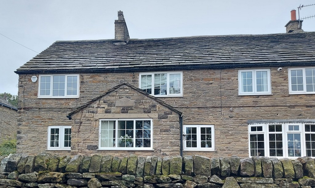
However, what if the owners were incorrect and mis-read an old deed? Or worse, anyone can commission a stone to be carved with any date they fancy. I’m certainly not saying that this is the case here, just using it to illustrate that there can be problems if we rely on a stone for a face value date. However, if we take that date as legitimate (which I am sure it is), then it provides us with a handy terminus ante quem for the track – the track goes past the house not to it, which implies the house was built after the track, so the track must already have been there in 1657.

I think these local tracks are largely medieval in date, and form a network that enabled people to move between the settlements that made up the Glossop dispersed settlement. And as time went on, more land was freed up, and new farmsteads sprang up along these routes. Thus, along this trackway that starts in Whitfield at the bottom of Cliffe Road, we see Whitfield Barn, Carr House, White House (with a side track taking in Jumble and Lower Jumble Farms). And, it follows, if we know where the original destination was, we can suggest an early date for that. The answer here is The Hurst on Derbyshire Level. Hurst is from the Anglo Saxon Hyrst, meaning ‘wooded hillock’, and which probably describes the hill immediately south-east of The Hurst. It is first mentioned as Whytfylde Hurse in the Feet of Fines in 1550, but an earlier date might be suggested by the rounded or ‘lobate’ shape of surrounding fields, indicative possibly of assarting (the process of converting forest into arable land), and what, to this untrained eye, looks very like ridge and furrow in the fields surrounding it. Both of these are largely medieval practices, and together could be quite telling. Hmmmmmm… I think The Hurst area needs a bit more looking into!
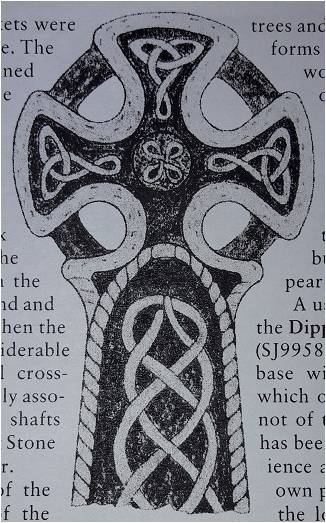
A CARVED CROSS

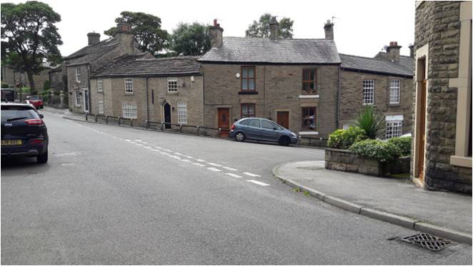
I blogged about a mystery white stone with a cross carved on it ages ago. I suspect that it (the stone, not the cross) is to protect the house from horse-drawn traffic, but why it has a cross on it, I still have no idea. Some months ago, though, I was sitting having a pint at the Beehive waiting to meet Mrs C-G, and vaguely staring at the wall ahead of me (I do love a nice bit of old walling!) when suddenly this came into focus:

The cross, worn, but definitely carved. As seen from the benches outside the Beehive. Cheers!

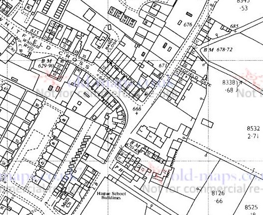
Given that it is on the same road, not 100 yards from the white stone, and carved in the same rough but deliberate way, it surely can’t be a coincidence… can it? The house on which it is carved – 61 Hague Street – also has a datestone of 1773, which provides us with a nice terminus post quem (the opposite of a terminus ante quem – a date after which it must have happened) – it can’t have been carved before 1773 as the building didn’t exist.

Nope, it’s all a bit strange, but I love a mystery.

And finally… yup, you guessed it. Drum roll please…

SOME POTTERY… BUT NOT LOTS!

A single sherd found between the setts of Bank Lane, Tintwistle, right by Bottoms Reservoir.

The sherd in-situ, nestled between the setts.

Nothing too interesting. I mean it’s a nice sherd of Transfer Printed Ware – probably a bowl, as it has flowers printed on the interior and the exterior.

Late Victorian pale blue & white. More delicate than the usual harsh blue stuff.

It is also unlikely to have been dropped in the last 100 years or so, and has thus laid there, between the cracks, just waiting for a dashing young(ish) and handsomely moustachioed archaeologist to find it. I was going to make this a full on pottery post, but it’s already too long, so the pottery will have to be next week, or so. I know, I know, but good things come to those who wait. And whoever is crying and yelling “no, no, dear lord please not next time” – you must try and control your excitement.

A TINTWISTLIAN TRACKWAY

However, back on track, and it’s Bank Lane that proves the focus, the sherd was just a way of getting onto the subject! This is a really interesting trackway, and is one of the two original (probably medieval) ways into Tintwistle from Hadfield, and before the Woodhead Pass bisected it (this stretch was made and improved in 1844 – look at that, another terminus ante quem!), it would have linked up with Bank Brow to get to the heart of the village. Incidentally, the other trackway goes via Lambgates, Roughfield, under the reservoir, and enters at the east of Tintwistle).

From the National Libraries of Scotland map site. Thank you.

So, Bank Lane then. It curves up, and just before it reaches the Woodhead Road, it runs below the retaining wall of Christ Church, Tintwistle.

A nice bit of walling, that.

As I said above, I do love a nice old wall, and I’m always aware that there might be interesting details hidden in them… and so it proved to be the case here. Firstly, I spotted this date:

Rather fancily carved, and definitely not the product of my imagination!

I think it reads 1841. Now Christ Church was built in 1837, is it possible that the wall was put in place 4 years later, perhaps replacing an older one? On balance, I think yes, but a quick rummage through the church records might reveal some detail.

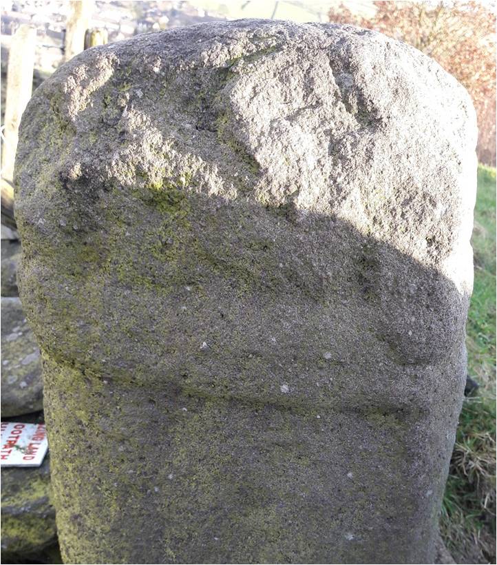
And then I noticed this:

Is it? I think yes, but I might be just seeing too much into it.

I am fairly certain that this is a set of initials, carved messily but cursively into the stone. I have made an attempt to outline what I think they are, but honestly it is entirely possible that I am just seeing things. I’ll let you, dear and gentle reader, decide for yourselves.

I mean… perhaps?

Possibly it reads ‘J. B’. Possibly?

And finally, another carved cross. This one looks more modern, and perhaps is a mark for where some utility is under the road? Not sure.

Possibly interesting?

Anyway, Bank Lane deserves a closer look. I have a whole ongoing project that is looking at these ‘original’ trackways that linked all the farmsteads in the area, as many are still preserved. It’s way more than a single blog post, but I’d like to do a series – examining each trackway, photographing it, marking it on the map, and recording any finds. Oooooh, that sounds exciting, I know.

Finally…

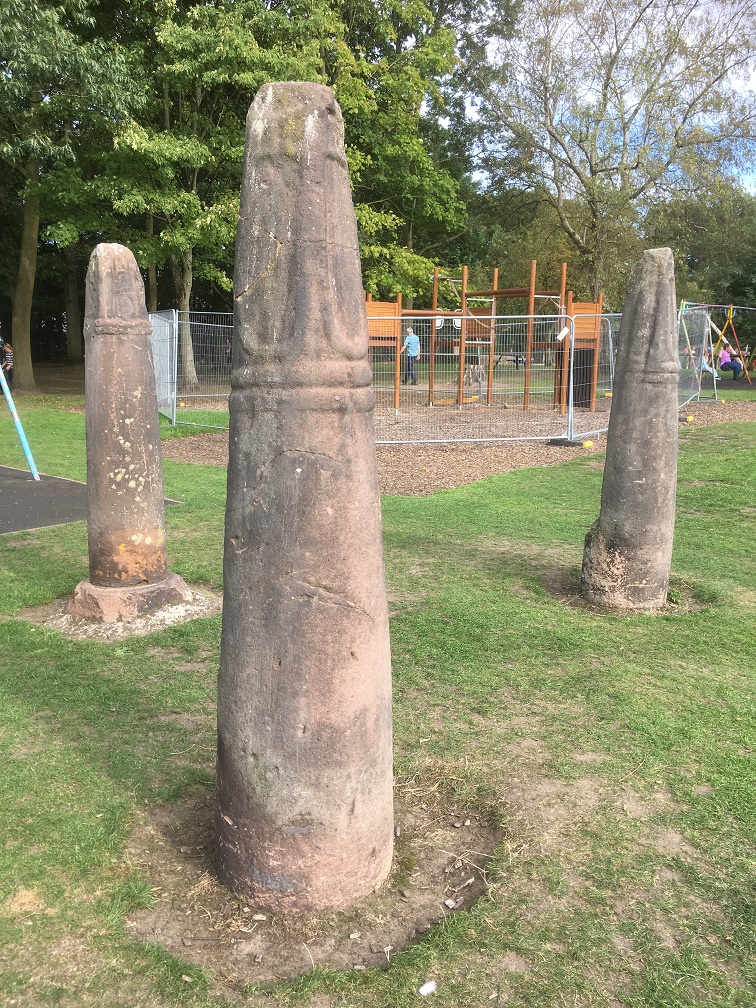
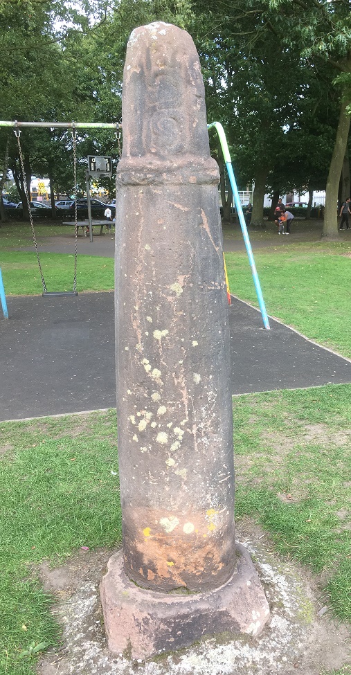
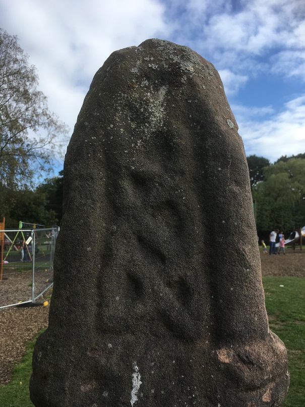
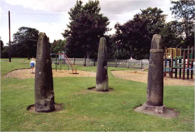
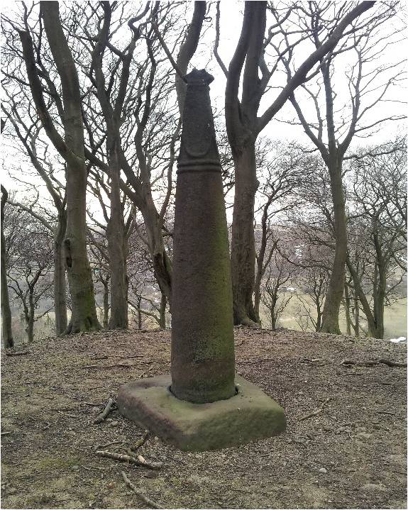
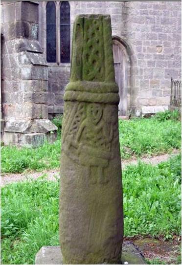
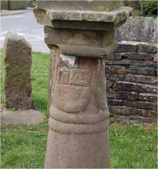
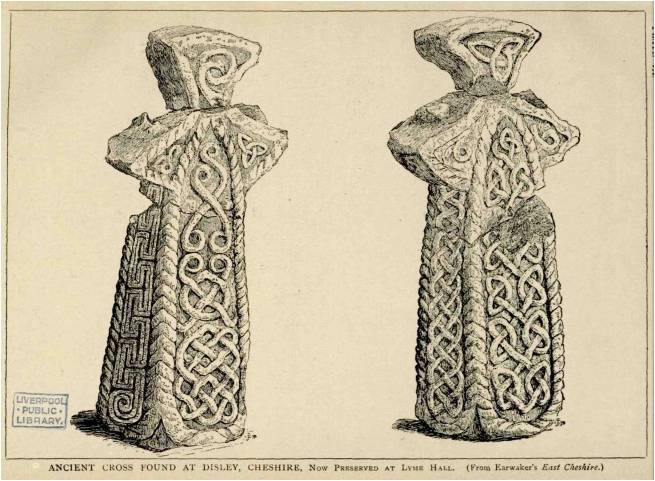
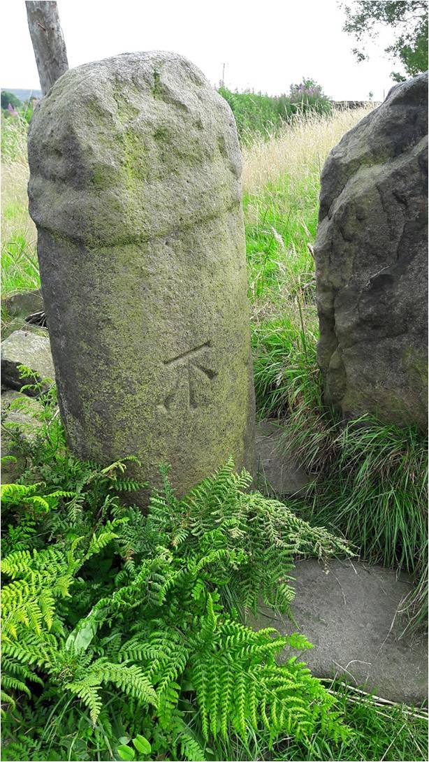
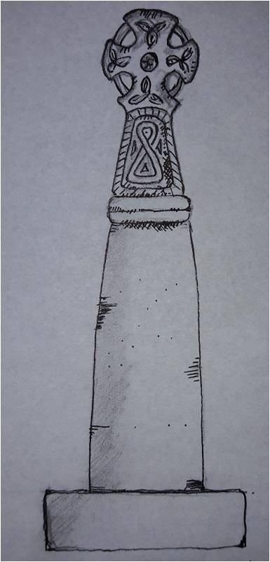
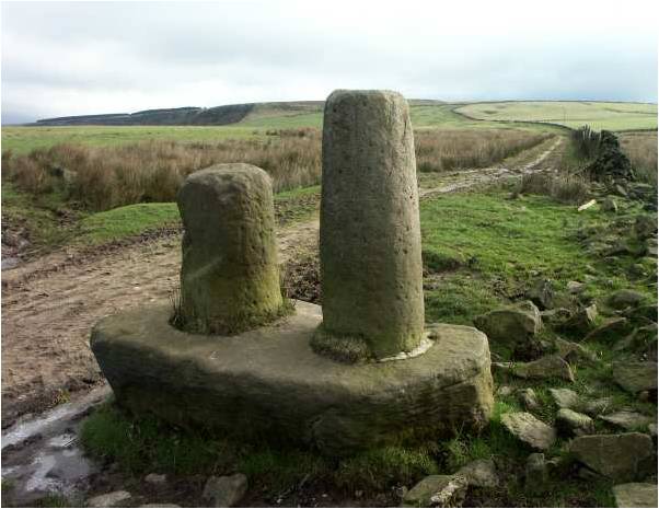
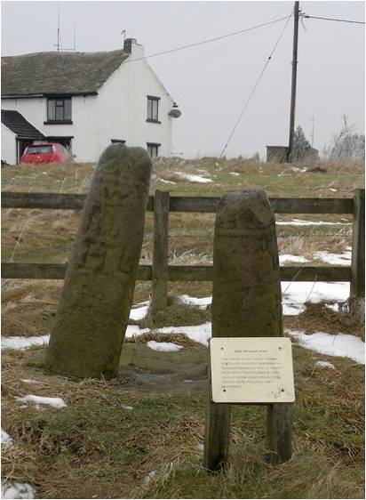
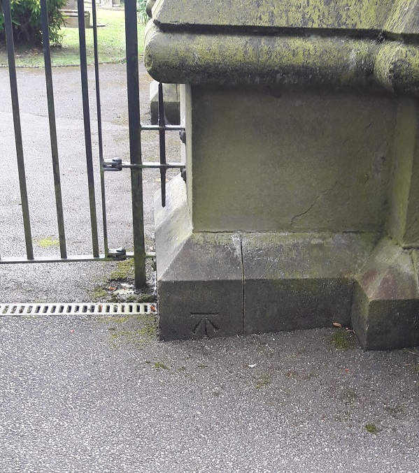
WHITFIELD GUIDE STOOP

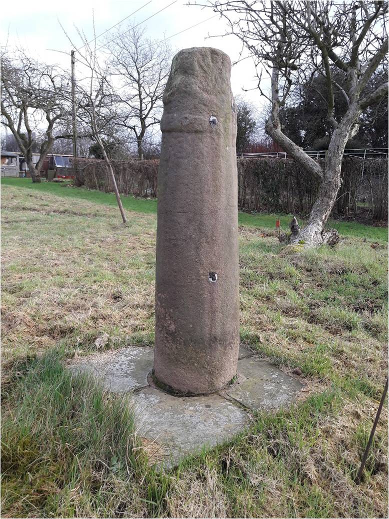
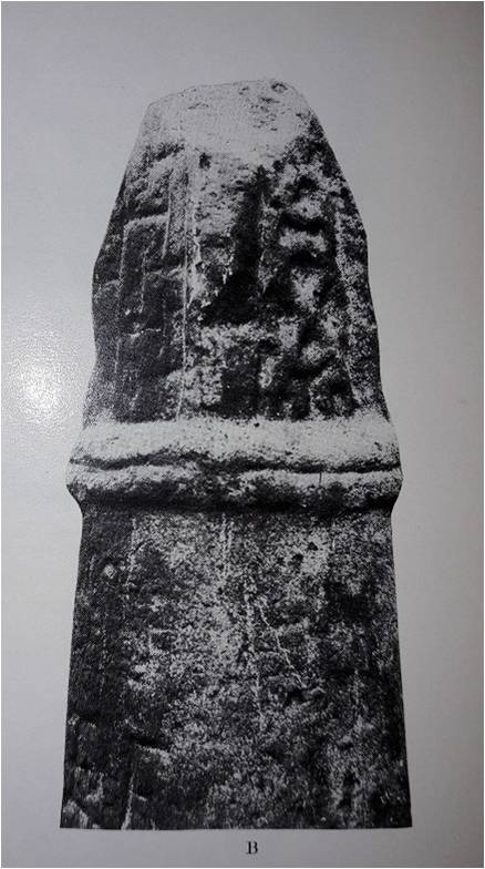
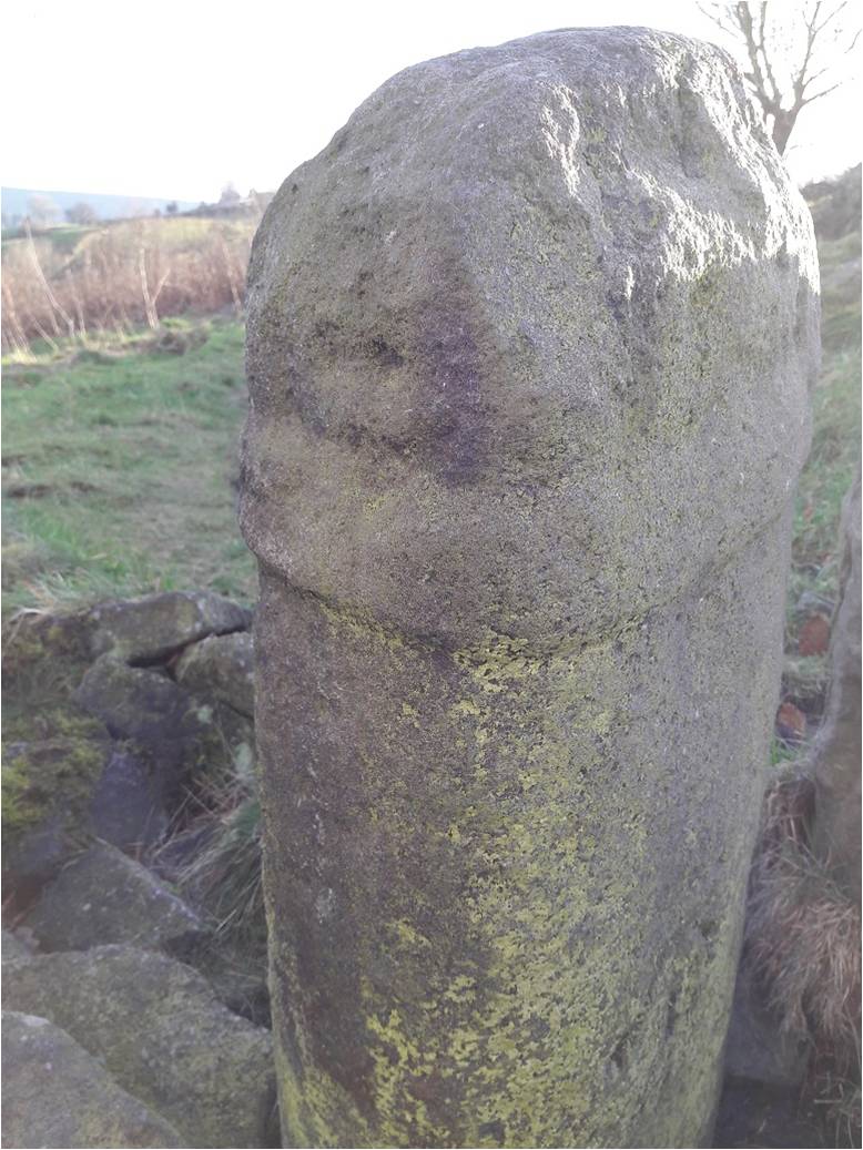
I have blogged about the guide stoop several times before, as it’s a vital part of the history of the area, and presents something of a mystery – please read here and here for the full lowdown.

The guide stoop.

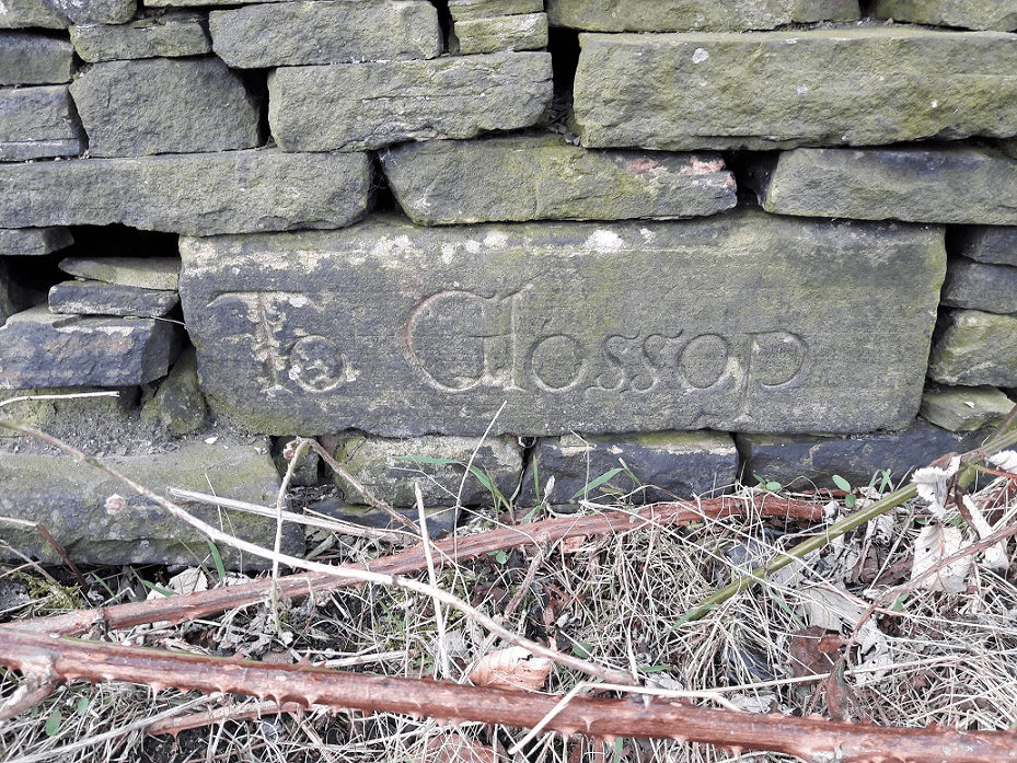
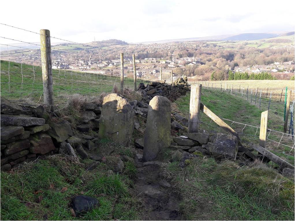
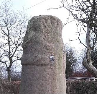
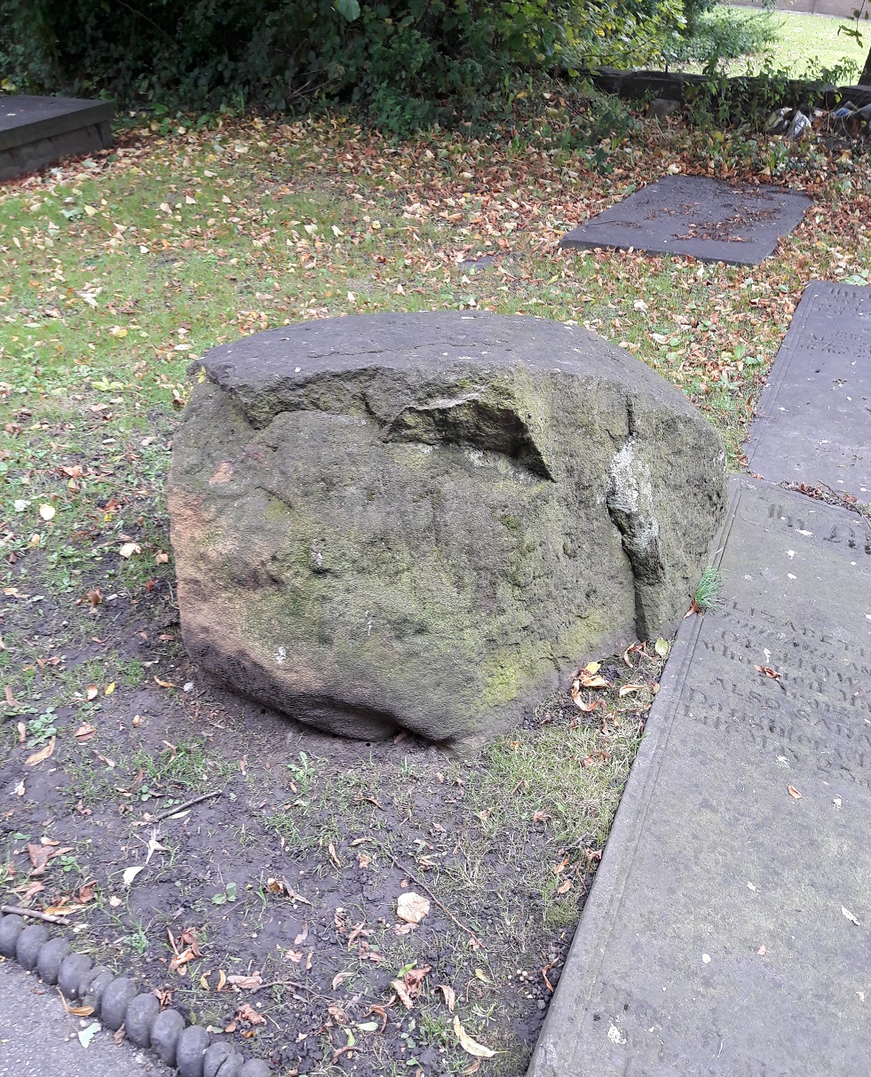
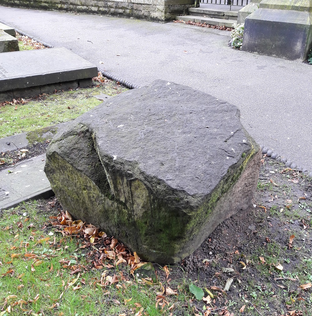
At the start of lockdown, I went on a walk past the guidestoop, and was horrified. Someone had had some work done in their back garden which required the rebuilding of the back wall and the removal of a large amount of soil. Whoever was doing this work had spread the soil along the track, at the bottom of the wall, and had completely buried the guide stoop in 2ft of earth. I mean, benefit of the doubt, they might not have noticed it. Here’s what it looks like currently:

Under here, somewhere.

If they did see it, however, then they were morons, and I just hope they kept the guide stoop in position, and didn’t steal it. Now, I haven’t re-excavated it yet for two reasons. Firstly, it’s a lot of earth, and a lot of brambles! And secondly, I’m not entirely certain where the guide stoop actually is under all that! all my photographs are of it in closeup, rather than a long view that gives a location in relation to the upper part of the wall. So, I have a favour to ask. Well, two actually. Firstly, does anyone have a long view that shows the top of the wall and the guide stone they could let me see? And secondly, does anyone fancy meeting up with a shovel, so we can dig the thing out and once again have back it on display? It shouldn’t be too much of a job. Anyway, drop me a line if you fancy volunteering.

Right, after that mammoth post, I’m going for a lie down! I will post the pottery in the next week or so – it’s largely written, and the photographs are ready to go, so it won’t take long… I can feel the wave of excitement from here.

Until then, look after yourselves, and each other. And I remain,

Your humble servant,

TCG

Whitfield Cross

Whitfield Cross – Sort of Update

A brief blog today…

Mrs Hamnett, Master Hamnett, and myself found ourselves passing through Macclesfield a few weeks ago. So I took the opportunity to visit the three splendid Mercian Round Shaft crosses that were erected in West Park there. I had tentatively suggested that one of them was a dead ringer for Whitfield Cross, and in a slightly better state of preservation. Definitely worth a closer look, and, of course, Master Hamnett was pleased as it means he got to go to the park.

The three cross shafts are located in the middle of the play area, and impossible to miss.

macc 1
The Macclesfield Crosses, situated in the excellent West Park in town centre.

They were originally sited together at Ridge Hall Farm in Sutton (about a mile south of Macclesfield – here). Two of them were being used as gateposts, with iron and lead fixings carved into the stone, and the third was in a pile of rubbish. Their importance recognised, they were promptly moved to West Park, arriving there on 7th January 1858. Interestingly, Ridge Hall Farm was originally a moated farmhouse of medieval date – the remains of the moat can be seen in the aerial photograph above, circling the farm at the south and west.

Now, although the crosses were ‘found’ together, I don’t think that the farm was their original site, and it is likely that they had been moved there from points unknown. The probability of their movement is given evidence by the fact that the farmer had two cross shafts on his land, exactly the right width and in exactly the right location to form a useful gate. And by the fact that one of the crosses was “in a pile of rubbish” – such wording suggests it had been moved and discarded, perhaps awaiting employment as a fence or gate post. Also, whilst they occur in pairs (and the gatepost pair may well be an example of this), we know of no other examples of three crosses occurring together. However, caution should perhaps be urged here; with so few examples of this cross type surviving, we don’t have a huge body of evidence from which to draw comparisons or to make bold statements, and as the old archaeological dictum runs, absence of evidence in not evidence of absence. But in this instance, and on balance, I think it is likely they had been moved. Given that Ridge Hall Farm is not near any parish boundary, nor is close to a church, we might tentatively suggest that they originally marked the junction of tracks, as Whitfield Cross once did.

But I digress.

The one that resembles Whitfield Cross is on the left of the three in the above picture. In the Cheshire and Lancashire volume of Corpus of Anglo-Saxon Sculpture (website here)  it is listed as Sutton (Ridge Hall Farm) 1, and dates it to 10th or 11th Century.  Here is a close up.

macc 2
The south-west side of the cross.

Although it is made of a similar stone, it is unclear if the cross base is original to the cross. I have to say, it looks like it might be, and if it is the case then we might suggest that this cross was in its original position on the farm. The other two crosses don’t have their bases, and it seems doubtful that the farmer would go to all the trouble of digging up the cross base, when he could just sink a hole and place the shaft that way. Also, if the other two had their bases, then the 19th Century antiquarians who were responsible for their movement would have taken them too.

The collar is of a very similar style to Whitfield – sloppily executed with a rough groove drawn around the neck, rather than two distinct bands.

macc 3
The Macclesfield cross – note the collar.

Picture18
Whitfield Cross – detail of the neck band. Similar in style to the Macclesfield Cross above.

I also suggest that the decoration which is missing from Whitfield would be of a similar nature to the Macclesfield example. Here is a closeup of the decoration. You can see what remains of decoration on the Whitfield example above and below.

Picture20
The decoration is, with the eye of faith, just about visible. Compare with those below.

macc 4
South west side, described in the Corpus as a “simple scroll, its three offshoots terminating in a triple round scooped leaves”. That looks about right.

macc 5
North east side, described in the Corpus as “crossing two-strand interlace terminating in a Stafford knot with pointed terminals”.

macc 6
South-east side – described in the Corpus as simply a “meander pattern”.

macc 7
North-west side, described in the Corpus as “two-strand encircled twist, with two loose and inward-turning ends at the bottom of the composition”

So there you are. This is what I think a little better preserved Whitfield Cross would have looked like had the puritans and drunken louts of the 18th Century not got hold of it. Having said that, I recently read about people digging up roadside crosses because they believed treasure was buried beneath them, which is another reason these crosses are so rare. Bloody barbarians!

Anyway, I know this is a long way from Glossop, but I think it is important that the comparison with Whitfield Cross is made and explored… who knows, the same craftsman or woman may have carved the crosses. And it’s interesting nonetheless.

Next time, I’ll be a lot more local… very local indeed.

As always, any comments and questions are welcome. There really is quite a thriving community of people out there, and it’s great to hear from you all.

Your humble servant,

RH

Stones of Glossop

The White Stone of Roe Cross

So, a while back I went looking for the White Stone of Roe Cross… and failed miserably in my mission.

As I said here, it is mentioned in Sharpe’s book “Crosses of the Peak District” as potentially marking the junction of the boundaries of Matley, Hollingworth, and Mottram, so I thought it would be worth a look, and maybe make a comment on what, where, and why.

I did some digging (pun fully intended), and came up with very little; it has almost zero presence online (other than this letter), and other than a modern book (about more, later), virtually nothing but an oblique reference. I began to despair… until I started to dig a little further – my ‘spidey sense’ began to tingle. Summat wants fettling, thought I.

What I did come across time and again was a reference to the legend of Sir Ralph de Staley, and his relation to Roe Cross, and the Roe Cross. Now, the story of Sir Ralph de Staley (Staveley or Stavelegh or Staveleigh – there are numerous spellings), is a variant of “The Disguised Knight”, a story trope that can be traced back to at least Homer’s ‘Odyssey’. Our story, culled from several sources, runs like this.

With Richard I, Sir Ralph sets sail on a crusade leaving behind his wife, Elizabeth, and estate. By and by, and following many great battles, he is captured by the Saracens, and held for many years in a dungeon. Eventually, he gains his freedom, takes on the appearance of a Palmer (a pilgrim), and pays a visit to the pilgrimage sites in the Holy Land. One night, in Jerusalem, he had a prophetic dream “boding ill to his wife and home far away”, and so, invoking the intercession of the Virgin, he prayed and presently fell asleep.

Upon awakening, he immediately knew something was different – “before him, shining fair in the summer sunlight, rich in fulsome melody of singing birds, was a fair English landscape, and beyond it his own ancestral hall of Staley”. He had been miraculously transported home.

He set off for his house, and came upon a faithful old servant and his favourite dog, who presently recognised him. He told Sir Ralph that his wife, who had finally given up all hope and now believed him dead, was to be married the following day. So off he jogs to his hall, and asks to see the lady of the house. He is refused, but begs a drink of Methyglin (a type of spiced mead, apparently), and after draining the cup, pops his ring into it, and begs the maid to take it to her lady. She does, his wife recognises the ring as belonging to her husband, and asks an important question “if it be Sir Ralph himself, he will know of a certain mole on me, which is known to none but to him” (racy stuff, this). Of course, all ends well and happily, and the bounder that is trying to get Sir Ralph’s lands and his missus, is ejected rapidly into the night. And quite right, too.

So ends the story.

Staleyhall
The 15th Century timber-framed Staley Hall before being done up. That is truly one of the most depressing photographs I have ever seen. How we can let our history end up in this state…

Staleyhall2
That’s better, although the wall at the front is a little off putting. The restoration work here is particularly good.

Now, here’s where it gets interesting. As a post script, most versions of the story (there are about 5, each with subtly different aspects) state that a cross was erected either where Sir Ralph meets the servant and dog, or where he wakes up following his miraculous movement. This is the Roe Cross – Ro, or Roe, apparently, being a shortened version of Ralph. Indeed, several sources mention a cross standing on the old road from Stalybridge to Mottram. But where is the cross? There is certainly not one there now, nor is there any evidence attesting to one. There is, however, the White Stone.

Ok, so here is what I think happened.

I don’t think there ever was a cross, not as such. None of the sources I consulted actually describes a cross, only that one was there (as told by the story and indicated by the name), or that there are the “remains of an ancient cross” on the road there (and thus presumably referring to the White Stone). It seems that the White Stone and the Roe Cross have become intertwined. Ralph Bernard Robinson, in his book ‘Longdendale: Historical and Descriptive Sketches‘ (1863) illustrates this perfectly by noting the existence of both cross and stone as separate monuments, but he only describes the stone, not the cross. I would argue that it doesn’t/didn’t exist.

It is most likely the name Roe Cross is derived from ‘roads cross’; the area is, after all, the junction of seven roads – Harrop Edge Road, Matley Lane, Gallowsclough Road, Mottram Road (Old Road), Hobson Moor Road and Dewsnap Lane. Indeed, according to Dodgson’s Place Names of Cheshire (Vol.1, p.315), there seems to be no reference to Roe Cross prior to 1785 (although this may turn out to be incorrect, with further research).

Roads Cross
Roads Cross = Roe Cross. You can see the coming together of all seven ancient tracks, converging on Roe Cross. Ignore the 18th Century Turnpike at the bottom.

So far, so good… now bear with me. The White Stone is a marker stone, marking tracks over the tops, and/or marking the boundaries of Matley, Stalybridge, and Hollingworth, and it has been there from the year dot. As a feature in the landscape, it was given a story, as all such features are – they accumulate stories, because people have an intrinsic need to have a relationship with their environment – and it takes on a personality, and gains a biography. As the archaeologist Richard Bradley says of monuments “they dominate the landscape of later generations so completely, that they impose themselves on their consciousness”. The story of Sir Ralph (whether ‘true’ or not) was given as a way of explaining both name – Roe Cross – and reason for the existence of the marker stone. In fact, in Ralph Bernard Robinson’s account of the legend, Sir Ralph wakes up “beside a large stone”, and later on notes that “tradition points out the stone under which he found himself laid: and a queer old stone it is.” Clearly he is describing this from his own personal experience, and surely there can be only one stone that is worth pointing out in the Roe Cross area… it has to be The White Stone.

As a postscript to the postscript, Sir Ralph and his wife, Lady Elizabeth Stayley, are supposedly buried in St Michael and All Angel’s church, Mottram. There are two 15th Century carved effigies that are to be found in the Stayley Chapel there, which almost certainly are meant to represent the good knight and his wife, and which were originally placed against the south wall of the chapel. As Aikin in his ‘Description of the Country Thirty to Forty Miles Round Manchester’ (1795) notes, “many fabulous stories concerning them are handed down by tradition among the inhabitants”.

Staly
This from Aikin’s Description of the Country Thirty to Forty Miles Round Manchester’

Staly 2
Sir Ralph and Lady Elizabeth de Staley. This taken from the official guide to Mottram Church here.

So then, the White Stone. Well, I still haven’t found it! But I do know a bit more about it, and now – drum roll please – I have a photograph of the bloody thing, stolen shamelessly from Keith Warrender’s book ‘Manchester Oddities‘. I heartily recommend this book, as it’s chock full of just the sort of odd bits of history that this blog looks at. Buy it here. Or better yet, order and buy it from Bay Tree Books – buy local and keep independent shops afloat.

So here is the offending stone, in whose shade, Sir Ralph found himself transported from the holy land.

White Stone a
The White Stone of Roe Cross – it is indeed a “queer old stone”.

The reason for it being white is presumably to make it stand out, to ensure this important stone (boundary marker, track marker, or teleportation stone) is kept vividly different from any other in the area. Apparently it’s now on private property, which would explain why I couldn’t find it last time I went looking for it. I’m not sure of its exact location, but somewhere in the vicinity of White Stone Cottage would seem to make sense. Here is the drawing in Sharpe’s ‘Crosses of the Peak District‘.

White Stone b
Not very cross base shaped, but then I haven’t seen it close up. Yet.

I love it when a legend has a physical mark in the landscape, it makes it more real, and as I say, it is a natural instinct in humans to build stories around their places. I recently led a guided archaeological tour of Alderley Edge, which looked at the Legend of the Wizard through an archaeological lens, and this same element, on a smaller scale, was at play here. Place and story working together, informing and shaping each other.

Apologies for the slightly rambling nature of this blog post, but I hope you enjoyed it.

As always, comments and questions are most welcome.

Your humble servant,

RH

Crosses of Glossop · Whitfield Cross

Whitfield Cross – The Talk

I gave a talk to the wonderful folk at the Glossop and Longdendale Archaeological Society on Tuesday night, on the subject of Whitfield Cross. I was honestly really quite nervous. Like most people, I am genuinely scared of speaking in public, and it’s not a thing that comes naturally to me. Indeed, research seems to show that people are more frightened of public speaking than they are of death – that is, they would rather be in the grave and dead, than standing over the grave and delivering the eulogy. However, I went ahead and did it – feel the fear, and do it anyway… as the rather cliched saying goes.

I think it went rather well, thankfully. Hopefully.

Anyway, here is the edited-for-blog transcript of the talk. It builds on the original Whitfield Cross post, but has lots of new information and photographs… so please read on, even if you have read the original.

I live in Whitfield.

For those of you who don’t know, Whitfield is a distinct area within Glossop, and was mentioned in the Domesday Book as a separate settlement from Glossop (as Witfeld), and remains a parish in its own right.

Now, my local pub is The Beehive, on Hague Street at the top – highly recommended, by the way – but in order to get to it, I had to walk up the steep hill of Whitfield Cross.

And every time I did, I pondered the name. Whitfield Cross is an odd name for a road that has no cross on it. I vaguely thought to myself, there must have been a cross here or somewhere nearby at some stage, but after a cursory scan on the internet, and a rifle through the local history section of the library, I drew a blank regarding the history of the cross. I must state that I hadn’t yet come across Neville Sharpe’s excellent book ‘Crosses of the Peak District’ which does have an entry for it, albeit a very short one.

However, sometime later whilst delving into the history of the area, I came across an article by our old friend Mr Hamnett entitled “Botanical Ramble to Moorfield”, dated to about 1890.

Picture4
Newspaper cutting stolen from the New Mills History Society – Visit the original via link here. With thanks.

There is not much botany, but it is an absolute goldmine of local history. And as I read the article my jaw dropped. I’m going to read you the relevant part here, as it captures perfectly what makes Hamnett so good. Plus the language is great!

“In the latter part of the last century the Cross Cliffe lads planned and partially carried out what was to them a most daring and audacious deed. One ”Mischief Night” the eve of the first of May, it was resolved to steal the Whitfield Cross. In the depth of night, when all was quiet, and the Whitfield lads were slumbering or dreaming of their “May birch”, the Cross Cliffe invaders came and detached a portion of the cross. With secrecy, care, and much labour, it was conveyed away nearly to its projected destination, but the exertions required for the nefarious deed had been under estimated, their previous work in removing all articles left carelessly in the yards or at the back doors of the good people of Cross Cliffe and neighbourhood, such as clothes lines, props, buckets, etc., etc., to their “May birch” had already taken much of their energy out of them, and, coupled with the steepness of the ascent to the “Top o’ th’ Cross,” distance and roughness of the road to Cross Cliffe, and the weight of the stone, they were reluctantly obliged to abandon their “loot” in the last field near to the pre-arranged destination. What the feelings were of the Whitfield lads on discovering the desecration and loss of a portion of their cross can be better imagined than described. The stolen portion remained in the field for some years. Mr Joseph Hague, of Park Hall, was solicited to restore the cross to its original form and position, but being imbued with a little Puritanism, he refused, and the other portions gradually disappeared until there is nothing left of the Whitfield Cross, except the stolen portion, which is now part and parcel of a stile in a field at Cross Cliffe, where the then tenant of the field placed it, over a century ago.”

“Blimey!”, I thought!

Date wise then, the removal of the cross would have been 1790 or so, and the cross would have originally stood at the junction of the road Whitfield Cross and Hague Street/Cliffe Road but we shall return to that in a minute. Cross Cliffe is at the top, along Cliffe Road, and it extends further off screen.

Cross Location
The cross would have originally stood dead centre of the above picture, inappropriately marked 666!

Upon reading this passage I quite literally pulled on my boots and headed up to Cliffe Road and went exploring. Alas, not knowing exactly where the cross was – and it is not marked on any OS Map that I have seen – I failed to find it. Weeks later, however, and walking for pleasure rather than exploring, I by chance took the correct path… and this was the sight that greeted me.

Picture6
The cross is the right of the two stones. Note Mouselow Iron Age hillfort in the background.

Now, I know what you’re thinking… what exactly is it?

Well, it’s a 9th, or more likely 10th , century Anglo Saxon stone cross of a type known as a Mercian Round Shaft or Mercian Pillar Cross. There are roughly 30 known examples, with doubtless quite a few more waiting to be discovered. Originally though… who knows. Hundreds? Thousands?

Most stone cross shafts are square or rectangular in section. The Mercian variety is defined by its round or slightly oval shaped shaft. It’s difficult to understand exactly what the crosses would have looked like from the Whitfield example alone – it is particularly worn and has been defaced. However, although no complete examples survive, by studying the better preserved examples we can begin to build up a picture of how they would have looked.

So then. There is the defining characteristic shaft.

Picture7
The round shafts are very obvious in this picture of the three crosses in West Park, Macclesfield. Photo and information here.

Round or slightly oval in section, and usually under 5ft in height, although some, such as that at Cleulow in Cheshire, reach as high as 7ft.

Picture8
Cleulow (or Clulow) near Wincle, Cheshire.

The shaft is normally plain and undecorated, although examples exist where this is not the case – Leek and Blackden for example.

Picture9
Leek cross, in the churchyard of St Edwards.

Picture10
The cross shaft at Blackden, Cheshire. You can just make out the very worn decoration on the side of the shaft.

A notable example is at Brailsford, where we can see a seated solder holding a sword.

Picture11
The seated soldier with sword on the shaft of Brailsford cross. Photo and much more info here courtesy of the Mellor Archaeological Trust.

The shaft tapers to a single, or more commonly, double band or collar that runs around the shaft.

Picture12
A single band on the cross at Blackden.


Picture13
A double band on the Shall Cross on Elnor Lane, south of Whaley Bridge (thank you David Dunford)

This band is not normally decorated, although at Leek, and elsewhere, it is (see above photograph for detail)

Above the band is a rectangular neck that is more often than not missing. Where the neck is present, it is normally decorated – often simply, but sometimes with complex knotwork and rope motifs such as these examples from Disley.

Picture15
Ornately carved, these two were possibly once attached to the cross shafts discussed below

On top of this neck the cross itself would have sat. Fragments, such as those from Disley, allow us to reconstruct the cross head – it would have been a ‘wheel’ type with four arms and a central boss, perforated, and probably heavily decorated with rope and knot motifs.

Picture16
A reconstructed cross head would look something like this – this is from Neville Sharpe’s book.

So, with this in mind, let’s look more closely at Whitfield Cross.

Picture17
Note the perfectly carved Bench Mark – the surveyors had no respect for heritage! Incidentally, this one is at 682 ft above sea level.

We can see immediately it is very worn. The shaft, made from the local millstone grit, is a lightly flattened round shape in section, and tapers slightly up to the collar. The collar is, at first glance, a single band. But, with the eye of faith, I think I can detect a groove running around its centre, meaning it would be a double.

Picture18
A close up of the double band – you can make out the detail quite clearly here.

It is worn, but I think would have originally been something like this.

Picture19
This is one of the Macclesfield crosses – we can see it’s a shallow groove, rather than a properly carved double collar.

Back to Whitfield Cross, we see the neck is worn almost beyond recognition, surviving only 6inches above the collar. However, and again with the eye of faith, I think I can detect the remains of knotwork or similar decoration.

Picture20
The relief work is perhaps visible – just about.

The depressions you can see on the neck are possibly the remains of the hollow parts, the relief, of the knotwork decoration. Look again at the photographs above, and then compare with the Macclesfield example above – you can clearly see the relief work and how it would look if it was worn.

As for the cross head… we have no clue. Instead, we must rely on Sharpe’s reconstruction for guidance.

So then, and apologies in advance for the rather bad penmanship on my part – I am a good technical drawer, but an awful artist – here is my reconstruction of how the cross might have originally looked, assuming all the ‘eye of faiths’ are correct!

Picture23
Reconstruction of Whitfield Cross – it now only survives a few inches above the collar.

So then, further questions are raised – the first of which is, well… what is it?

It’s a cross… obviously, but what is the meaning of it, why was it carved, and why is it here?

The urge to leave a mark in the landscape is undoubtedly a universal feeling, and one that has been with us since we humans first started ‘thinking’. Stones have often been used to leave this mark, to somehow own the land, and to act as a focus, I’m thinking prehistoric standing stones, here. Stone crosses are very much a continuation of this act of permanently stamping yourself into the landscape.

But they can convey much more information.

They were often placed as boundary markers, showing where parish, territory, hunting rights, farmland and such begin and ended. Indeed, there are many stone crosses in the area that do just that. They act as a reminder of the adoption of Christianity in the area, a symbol stating loudly that “we are Christians”. It may also have been used as a gentle reminder that “you are Christians, now” as certainly in the early Saxon periods, and with the later Scandinavian incursions, the old pagan Gods were never far away, and it was far from certain that Christianity would prevail.

However, if we look again at where the Cross originally stood, we can see another, more practical, purpose for the cross – that of marking an important junction in the contemporary roads.

Map

So, we have the old pack horse route that comes from the south – Peak Forest, Buxton, and Chesterfield – to Old Glossop, and on to Woodhead and Yorkshire, beyond, and now called Hague Street/Cliffe Road. The cross would have marked the junction of the track that went along Whitfield Cross and Hollincross Lane, and onto Simmondley and beyond. There was another spur coming out along what is now Gladstone Street, leading to that area of what is now the town, and again onto Woodhead.

Picture25
The Junction at the top of Whitfield Cross in real life.

It has been suggested that some roadside crosses were placed as a gift of thanks for the completion of a safe journey, effectively a votive offering in payment for an answered prayer (i.e. help me get home in this awful weather, and I’ll set up a cross to say thank you). They might also function as a spiritual fortifier, reminding the traveller of God’s watchful eye and his protective power over the faithful. It is easy, I think, in these days of surfaced roads, street lights, and large settlements, to forget just how dark and treacherous travelling in the pre-modern era was – making your way from A to B in total darkness, along a muddy track, and with no map as such, and knowing that if you took a wrong turn somewhere, you were lost.

There is also a further, more subtle, reason, too for the cross being here. Actually, one that perhaps wouldn’t have been that subtle when it was first carved and erected, and this reason is tied in with another important question: Who made it?

It is known as a Mercian round shaft because it occurs only in the Anglo Saxon kingdom of Mercia. However, that is to massively oversimplify the answer, and it is more complex and more interesting than that.

Picture26
The Kingdom of Mercia in early 10th Century. The Peak District is the top right section.

Mercia was for a time, the dominant kingdom in Britain, but by the 9th & 10th centuries it had lost that dominance to Wessex. Even so, we can see that the kingdom is still a massive area. The occurrence of these particular cross types is confined almost completely to the northern part of the kingdom, and specifically where we are now – north west Derbyshire, east Cheshire, and northern Staffordshire: in short, the Peak District.

One of the smaller kingdoms absorbed by the Mercians was that of the Pecsaetan, literally the people of the peak, and who probably gave their name to the Peak District. They seem to have been a distinct tribal grouping, relatively autonomous, but owing tribute and allegiance to the King of Mercia. Interestingly, the land upon which the Pecsaetan farmed and lived, coincides precisely with that in which the crosses occur – Northern Mercia.

I am speculating, obviously, but it is possible that this specific cross type is a product of the people of Pecsaetan kingdom, or at least what remained of it. Moreover, this was at a time – the 9th and 10th centuries – when the Mercian dominance was on the wane – just the time that a little national pride would be in order. And thus, we may speculate that the cross – a region or people specific type – might even have become a symbol, or totem perhaps, for the Pecsaetan kingdom.

There are other examples of Mercian Round Shafts in the area. As I say, there are about 30 known crosses, give or take – there seems to be no definite number recorded, and doubtless there are more waiting to be uncovered. I note that the Derbyshire section of the book series the ‘Corpus of Anglo Saxon Stone Sculpture’ is due to be published, but without having a spare £100, I’ll have to wait until the library gets a copy to check what it says about the crosses.

Our nearest examples are Robin Hood’s Picking Rods in Ludworth, roughly 3 miles south west of Glossop.

Picture27
Robin Hood’s Picking Rods.

Originally known as the Maiden Stones, these are an example of a double cross, that is, two crosses set up side by side. This seems to have been a feature peculiar to the Mercian Round Shaft, but it is unclear what the purpose or meaning of this was. The Picking Rods sit on the parish boundaries of Mellor, Ludworth, Thornsett, and almost that of Chisworth. Perhaps then, the fact there are two of them may be related to their importance in marking this out – with two different parishes choosing to erect a cross each. Another possibility is that they were originally two separate crosses, but were brought together at some stage in the past – with perhaps one of them originally marking the parish boundary for Chisworth.

There is another pairing of crosses to be found in Disley, some 10miles or so south west of Glossop.

Picture28
it is possible that the cross necks illustrated above may have once sat upon these shafts.

These too have no obvious reason behind their pairing, and although they have been moved from their original site, the old, double, cross base is still there marking the place.

Other, single, examples of Mercian Round Shafts are to be found at Macclesfield, Fernilee, Bakewell, Alstonfield, and notably Leek. Importantly, at Bakewell and Alstonfield, there are large numbers of cross shafts and heads, which, suggests Neville Sharp, may be where some were made and distributed.

What then, does the cross tell us of Glossop in the so-called Dark Ages?

Sadly, not very much. The post-Romano-British period is massively under-represented in the area, to a point where it is virtually non-existent – there is the possible glass bead from Mouselow, and that is about it.  And yet we know something was here as Whitfield, Glossop, Chunal, Hadfield and Padfield are all mentioned in the Domesday book – they are clearly important enough to be counted. There is also the possibility that All Saint’s church in Old Glossop has a Saxon origin, but that is currently unproven. Neville Sharpe in his book Glossop Remembered suggests that the lack of a Saxon presence in Glossopdale may be due to a lack of interest and funding by local landowners prior to the area being industrialised. This may be the case to a point, but we do see Roman material coming to light from that point in Glossop’s history, so where is the Saxon?

No, seemingly all we are left with is the monuments – Robin Hood’s Picking Rods… and Whitfield Cross.

Picture6
Our single link to our Saxon past.

What the cross can tell us, though, is that Whitfield, and by extension Glossopdale as a whole, was clearly in contact with other areas of Mercia. There was no mass media, and so the particular style of cross – the Round Shaft – could only have been communicated and spread through contact and travel. Even in this insular and provincial northern part of the kingdom of Mercia, it seems that the Glossop area was very much a part of the greater Anglo Saxon world with access to all that that brought.

And there it sits, a single monument to the late Saxon inhabitants of Glossop – the most tangible connection we have with the residents of the area at that time.

And sadly one of the most overlooked.

I would love to see the cross moved from its present location and placed somewhere where it can be seen and understood by everyone, as a vital part of the heritage of the area. I have suggested before that the wells on Whitfield Cross, the road, would be ideal, but that is a project for the future.

Thanks for reading, and apologies for the lengthy post. As always, any comments, questions, or corrections are very welcome.

RH

Archaeology · Crosses of Glossop · Whitfield Cross

Whitfield Cross – The Talk (of The Town)

Greetings to you all.

Well, so far I have managed to fail utterly in my New Year’s resolution in posting at least once a week. So my apologies. A lot of my spare time has recently been taken up with writing and preparing for a talk I am going to give on the subject of Whitfield Cross. Interestingly, the Whitfield Cross post (here) is by far and away the most popular on this blog. I know this because behind the scenes here, there are a whole pile of statistics that can be accessed that tells me how many people visit each day, what they look at, and even from where they come – yesterday, for example, I even had a visitor from South Africa! Now, I have no idea why the Whitfield Cross post is so popular, but when I was asked to give a talk on any subject, I though I’d go with that!

The talk is titled: Whitfield Cross – Glossop’s Saxon Heritage

To be given to the excellent folk of the Glossop and Longdendale Archaeological Society (website here) on Tuesday 3rd April at the Bluebell Wood pub, Glossop Road, Gamesley. Talk starts at 7.30, so get there a little earlier, and it’ll cost £2 on the door (although for £5, you can join GLAS and reap the benefits for the year).

The talk will draw on the blog post, but will include new research into Glossop’s only Anglo Saxon feature, and include a discussion of other examples of Mercian Round Shafts.

Plus, this is your chance to find out who Robert Hamnett actually is… and buy him (well, me) a drink!

In all seriousness though, come along – if you are interested in the blog, or Whitfield Cross, you’ll be interested in this.

Right, despite having another cold (courtesy of the ever ill James), I shall try and bash out another blog entry

Archaeology · Crosses of Glossop

Hollincross Lane Cross

In his book ‘Crosses of the Peak District’, Sharpe (2002) lists Hollincross Lane, by St James’ church, Whitfield, as being the site of one of Glossop’s long lost crosses (p.110, paraphrasing Hamnett). When I had previously thought about Hollincross Lane, I had assumed that the name refers to the Whitfield Cross, and thus the road that runs down into Hollincross Lane via Freetown. But actually, a cross here would make sense as it would mark the junction of three trackways: north to Woodhead and beyond, east to Whitfield and thence to (Old) Glossop or Chunal via Gnat Hole, and west to Dinting and Simmondley. The way south, Charlestown Road, only came into existence with the construction of the turnpike road in the early 19th century – before that, the only way to Chunal was via Gnat Hole.

Hollincross Map
1969 1:2500 map showing routes north, east, and west. The hypothetical situation of the cross would probably have been at the church end of James Street

A cross marking this junction would have had its uses, then. Indeed, we can also play a speculation game (putting on my prehistorian’s hat for a moment) and suggest that the siting of St James’s Church (1840 or thereabouts – the foundation stone was laid on 27th September 1844, and it was consecrated almost 2 years later on 8 September 1846) was influenced by the existence (or memory) of a cross there indicating holy ground. Wild speculation, I know… but let’s pretend! Etymologically speaking ‘Hollincross’ may be understood as either ‘Holy Cross’, or ‘Holly Cross’ – a cross covered in or situated by some holly

Now obviously there is no cross there now, and Hamnett, writing in the late 19th century, could find no trace of a cross either – seemingly it’s location was lost to even the oldest residents of Whitfield. At some stage, then, our hypothetical cross has been removed. This could have happened for any number of reasons, ranging from pious iconoclasm (a stone cross is an object of adoration and thus ‘Popery’, or Roman Catholic veneration of things and people) to it simply being in the way of traffic. I know of one example, not local, of a 9th century Mercian Roundshaft that was rescued from a farmer who was in the process of rolling it down a hill and into a stream in order to plough his field. And this was in the 1960’s…

Crosses and bases were, then, broken up and re-used in walls, and as people don’t move stone further than they have to, especially in a stone rich area such as this, it sometimes pays to have a look around to see what you can see. With this in mind, and taking advantage of a lull in the rain, James and I went for a wander down to St James’ churchyard (via the park, obviously). He had a whale of time, helped no doubt by the drink of juice that the rector gave him! So, what did I find? Nothing definite, certainly, but just possibly, something.

Hollincross 1
A stone amongst the stones. What is this lump?

Just opposite the main entrance to the church, by the path and amidst the gravestone sits a large lump of stone. It is roughly 2′ square and 1′ high, has been knocked about a fair bit, and is now fairy shapeless. However, one side has clearly been shaped and worked, and with the eye of faith one can see chisel marks.

Hollincross 2
The side closest to the camera is flat and has been worked by tools. Is this the base of Hollin Cross?

Now, I am not sure what this is! It is not a glacial erratic as they are often rounded and smooth like a pebble, and I don’t think it is part of the church building, as it is the wrong type of stone. It might be the cross base, but there is no visible socket – the hole in which the cross shaft sits to make it secure. However, the socket may have been on the part that has been knocked off, or is perhaps underneath if the base had been up-ended. It is very uncertain, but we can be sure that the stone was not planned as such to be there – it makes no sense, and doesn’t even have an aesthetic value – rather it is a left-over from the land prior to the construction of the church.

I had a look around the walls for cross pieces, but could find nothing likely, and I think a winter trip around the churchyard is in order!

Of course, whilst I was there, I took the opportunity to photograph the bench mark on the church itself – how could I resist!

BM - St James, Whitfield
548.9 ft above sea level, to be precise. That’s a roughly 120 ft difference between here and the top end of Whitfield Cross.

Any thoughts or comments are always welcome.