What ho, wonderful folk! Apologies for not publishing something sooner than today… truthfully, I have been a little overwhelmed and burnt out. Recent events have caught up with me, and I’m tired and somewhat sore; nothing a breather couldn’t fix, but sometimes it all becomes a little too much – please do listen to your bodies and minds, as they will often steer you on a correct course. Anyhoo, I’m back, and happy to be so. So here we are, with a long overdue post.
Last March, I went on a little Wander with a friend and family (hello GW). We had set off to do the first Where/When Wander, but having kids with us, we ended up playing around in the land by the allotments and behind Dinting Station. Aside from the fact that the area is interesting from a historical perspective (being connected with Dinting Station, and filled with old bits and pieces), it was also the location of the old Dinting Railway Centre/Museum. I vaguely remember visiting the museum several times as a child, and I recently bought a vintage guidebook on Ebay to try and fully remember what it was I went to.
The centre finally closed in 1990, and whilst all the trains and exhibition pieces moved elsewhere, the infrastructure – rails, and platforms, and buildings – all remains (here is a good article about the museum’s rise and fall, and there’s loads about it on the internet). Central in this wasteland – or forest of Silver Birch – the Engine Shed still stands, alone, derelict, and graffiti covered.
Here’s what it looked like in 1967, before the Railway Museum…And here’s a similar shot, nearly 60 years later, and after having been a museum in the meantime. Blimey! Honestly, the building is in there. Our old friend Boof makes an appearance, here represented by his/her older tag, and a newer (2025) bubble piece. His/her tag is all over the site.Some of it is quite good, this piece in particular ‘OMENS’ (strangely unsigned, presumably Omens is their ‘tag’), and this one……are very artfully done. Love the window in the background/part of of this one. So this is interesting. Because I am that sort of person, I knew this was something when I saw it. Rather bafflingly, this is the sigil of Foras, one of the 72 demons mentioned in the 17th century Lesser Key of Solomon. Apparently he was the president of Hell, and was associated with precious metals, logic, and lost things. Quite why his sigil is painted on the wall here is beyond me; teenage rebellion or demonic invasion? You decide.
Anyway, comparing the photographs of then with now is really quite interesting, and shows just how quickly nature retakes land back, even heavily used and industrialised land such as this. Give it another 100 years, and there will be very little recognisable, 500 years and it’ll need an archaeological excavation to make any sense of the site; understanding site formation processes like this is vital as an archaeologist, and our case study is right here.
But today’s article is less about the centre, and more about a single aspect of the site. As generally happens, when a building is left derelict and unused, it slowly breaks down, and this is the case with Dinting station’s southern waiting room. Built in 1884, when the original 1848 station was rebuilt, you can see it from the train behind a fence; overgrown, derelict, absolutely terrifying. However, I didn’t know you could access the station from the back, via the patch of ground we were exploring. Well, I mean to say… one cannot simply say no when such gifts are presented to one! I had a brief explore! Brief because: a) I was probably trespassing, although it is very unclear to be honest (and I was by no means the only person there that day… or even that hour!), and b) we had children with us, and the place is phenomenally dangerous, with broken glass, falling masonry, and Jove knows what else. It was also going dark, and, I’m not going to lie to you, the place is spooky! Before we go on, I am also going to insert a cautionary statement here: I absolutely do not endorse you going to the place to look, and in fact recommend you don’t. So I took a very few, mostly terrible, photographs, and scarpered.
The station building from afar… the Silver Birch trees are amazing in this photo – and I actually find them frightening here. Random brickwork, and an odd framed shot of a corner with shamfered edged stone. Look, I had a quick look around, and then legged it! I wasn’t taking my time with perfection! Lovely Stoneware bottle; possibly a large ink bottle, but I suspect it is something more industrial – a chemical or oil, perhaps. The whole area is filled with burnt cinders and rubbish, amongst which are many interesting finds. It’s a beautiful building. Or at least could be. These windows are lovely, but then through them you can see sky through the roof. How long does this place have left before it all collapses? Who knows. The doorway, with what looks like a Cheshire sandstone lintel. I honestly feel something should be done about preserving this building. I don’t know what could be done with it, but something more than just leaving it to rot… surely?
So I had a quick look around, as you do, and in doing so, I noticed that the whole roof of the exterior platform area had collapsed, seemingly as one, and the floor was littered with rotting wooden roofing and broken slates. And then I saw it… a single slate seemed to have survived intact-ish. I pulled it up and thought… I say, here’s a nice little blog entry! And so here we are:
Amazingly, it had both copper nails still in-situ, and whilst it has broken a little at the top, it allows us to see how it was made.
The rougher edges are very characteristic, and I think I can see the result of individual hammer blows. Possibly.
Geologically, slate is dense, and was laid down in thin layers, which allows us to quarry it and split it into relatively thin sheets using a hammer and chisel. It is further shaped using a soft hammer whilst over hanging a hard edge (or later using a machine, although still hand held). There is a fascinating YouTube video here that shows the whole process, for those who like to know… it makes it look so easy! This gives it the characteristic nibbled edges.
The different areas of dark colouring on the slate itself is the result of differential exposure to smoky polluted air, with the bluer/greyer bits being protected by wood or other slates.
The holes to take the nails were made probably with a metal punch – a single blow delivered from a hammer on one side, and the force of the strike spread and created a characteristic ‘exit wound’, much wider than the entry.
The ‘entry wound’. I wonder if these have been partly drilled before being punched?The devastating ‘exit wound’.
Looking at the nails themselves, they are fairly standard mid/late Victorian copper nails, hand finished, and square in section.
I honestly love these things. The back side, showing the nail through the hole.
These wonderful things seem to be attracted to me, and I find them all over Glossop, or maybe it’s just I’m always looking down (I’m going to be Richard III-like before I’m 60 at this rate). And, as I can never resist them when I find them, I have quite a few, here in CG towers. I say “quite a few” like it’s 10 or 12. I actually have hundreds of the buggers, hiding in labelled bags, naturally, and hidden in drawers, but shhhhhh… don’t tell Mrs CG, this sort of thing makes her twitch. I wrote a little about how they are made, here, in this article, 8 years ago… man, do I feel old!
What a difference Welsh roof slates would have made to housebuilding. As I type this, I sit under a roof made from locally sourced gritstone (I think I can see the quarry from my house); each roof tile is an inch thick, solid stone, and I bet the whole roof must weigh somewhere in the region of 5 tonnes, with each individual tile moved up and positioned by hand. I watched them do it when my roof was re-laid, and it took a long time. Now think of the slate; each tile weighs a tenth of the stone one, meaning more could be carried up and laid quicker, it costs less per tile, and overall does the same job, but at a fraction of the weight of the roof, meaning smaller beams could be used. It’s no wonder that Welsh slate tiles took over almost immediately, ironically being brought here – safely and quickly – by the train. In fact, you can use the presence or absence of a slate roof as a quick and easy way of dating the buildings here in Glossop: stone roof, built pre-1850(ish), slate roof, post 1850(ish)
So there you go. Right, I have another article almost finished, and I’ll try to get it out to you before New Year, but I’m not going to make any promises! Just know that I’m always trying, but sometimes life gets in the way of this, what I want to actually be doing with my time!
Before I pop off, the new Where/When is now available – woohoo! #8 – The Bullsheaf Shuffle.
This edition is a great one! Two smaller Wanders to tickle your festive season.
Two Wanders, both starting and finishing at a pub in Old Glossop, and neither very long, but all filled with history – medieval field systems, prehistoric remains, Ordnance Survey benchmarks, Roman roads (or not!), post-medieval trackways, Georgian buildings, a Victorian rifle range, and bits of pottery! A perfect stocking filler, available from here, or from Dark Peak Books, in High Street West, Glossop. All back issues are also in stock again, too, so knock yourself and grab a couple!
Right then, I’m off. Lots to do, annoyingly – the Christmas season is so wonderful, but equally is a real faff! As is work… and real life. However, until we next meet, please do look after yourselves and each other – you are all very important, even if you don’t know how, and to whom.
What ho, delightful historical types (hysterical types?)! Welcome to a new article… don’t worry too much, it’s not pottery (I’m saving that for next time). Nope. This one looks at an interesting feature of Glossop’s personality. Buckle up!
So, some posts I can polish off in an evening (glass of stuff that cheers in hand, obviously). Others takes weeks to brew, and the process can be painfully slow. This one, though, is very different. I started writing it in August 2017… and it’s taken just under 8 years to publish it! No reason as such, it’s just I paused writing it, and moved onto something else, then I went back to it, and then did the same, and so on, and never quite finishing it. In fact, it’s so old, that it was written using an older version of WordPress (the platform I use for my website) which wasn’t really useable any more, and I had to paste the entire thing onto the newer version. Well, here we go.
It’s often said that Glossop is a town of different areas, and with different character. When I first moved here, I realised that a lot of these areas were named ‘town’ – Howard Town, for example. On a simple level, ‘town‘ here refers to a collection of houses in an area rather than the traditional meaning of a large urban conurbation. I wonder of this is a local dialect, or perhaps more likely, Howard Town was named as such, and then the others followed suit, possibly ironically (Roughtown), or perhaps as a way of keeping in fashion (Milltown? Anway, this and is a which got me thinking… how many of these towns are there? And where are they all?
Well, in answer to these questions, may I present…
MILLTOWN
Despite its location, and seemingly obvious derivation, Milltown as an area has nothing to do with the Victorian mills, but instead it is so named because of its proximity to the medieval corn mill. Situated on what is now Corn Street, the mill was owned by the Lord of the Manor, and the people of the area paid to have their corn ground there – and nowhere else. It was, to all intents and purposes, a bit of a racket, but one that was universal throughout the land at the time. As you can see from the map below (and from photographs), there was a flour mill here in 1898, an 18th century building replacing an earlier one. It was demolished in the 1920’s, but you can still see the mill leat running alongside Corn Street. Also, the bridge over Shelf Brook as called Cornmill Bridge, which I did not know until just before I wrote these words… I love that!
Milltown marked in orange, to include the Corn Mill. In reality, Milltown is now just the area to the south of High Street East. On the map above, you can see the Corn Mill (1), Corn Street (2), and Cornmill Bridge (3). Milltown as a present day place is that to the south of High Street East, and comprising Milltown (the street) and Mill Street (4). The area has changed massively, but one constant is the Prince of Wales pub on the corner of those streets (I blogged about it here); pubs are often the only thing left after whole streets are demolished, as indeed is the case here.
LEAN TOWN
Lean Town is the name given to a group of four houses at the bottom of an apparently unnamed lane that runs from Hague Road to Gnat Hole. I can’t believe it is unnamed, but there you go… no map or document has so far given me a name! As you come from The Beehive toward Derbyshire Level, you pass a right hand downward track – follow this and eventually you hit Lean town. I wrote about Lean Town, here.
Lean Town. 1 is the track down from Derbyshire Level, 2 is Chunal.
The origin of the name ‘Lean Town’ is unclear; it might mean lean, as in not very rich, or poor for growing crops, or might be derived from ‘ling’, meaning the plant ‘heather‘ that grows around here.
CHARLESTOWN
Once an area in its own right, it is now largely remembered in the name of Charlestown Road (and Charlestown Motors who I can heartily recommend, as it happens). It was named after Charles Hadfield who lived in Lees Hall in the late 18th century, and built the mill in Charlestown (now flats and houses).
Sort of this area, give or take. Charlestown Road runs from top down, and the PH (Public House) marked on the map is now Steak Land (replacing a firm favourite of mine, Casa d’Italia, although the word on the street is the Steak Land is amazing, so there’s that!)
ROUGHTOWN
Hope Street in Old Glossop was known as Roughtown, seemingly referring to the uncouth behaviour of its inhabitants, largely quarrymen from the nearby Glossop Low Quarries just up the road.
1 – Hope Street, 2 – The Greyhound pub, a factor in Roughtown’s reputation.
Apparently Roughtown was used as a semi-official name, with it appearing on census returns and trade directories of the time. Sticking with Old Glossop, we have…
TOP O’ TH’ TOWN
The area between Thorp Street and Church Street in Old Glossop. It is, I suppose, quite literally the top of the town.
And the area at the end of Top o’ th’ Town is known as ‘Town End‘, which make sense. Over in Whitfield, however, we have…
FREETOWN
Stretches from the bottom of Whitfield Cross to the junction with Charlestown Road.
This sort of area, here. and particularly the road called Freetown.
Technically, and originally, Freetown was the name given to this area of Whitfield, with the name being derived from the fact that the land in this area, and subsequent houses built here, were freehold, as indeed it is still the case (my own house here included).
HOWARD TOWN
Essentially, what we understand as Glossop – the railway, Norfolk Square, the crossroads, and the whole area around the market and Wetherspoons.
Named after Bernard Edward Howard, 12th Duke of Norfolk (1765-1842) who invested heavily in Glossop – money and time. He built roads, the town hall, remodelled the whole area, and changed the focus of Glossop from what we now know as Old Glossop to what we now know as Glossop, but was originally Howard Town. This may have been the start of the ‘town’ naming process, as others followed suit, whether by flattery or through satire.
JERRYTOWN
A bit of an obscure one this – it’s mentioned by Hamnett as stretching along High Street West, from roughly The Grapes inn to the former Junction Inn and around.
1 – The Grapes, 2 – The former Junction Inn (now Simple Lettings), 3 – Primrose Lane.
Apparently named after a Jerry Sykes (1779 – 1856) who built a number of houses in this area in the 1820’s.
And there we have it! The many towns of Glossop town. I can already feel several of you desperate to tell me that I’ve got something wrong, or that I’ve missed a ‘town’ out. Please feel free to do so. Honestly, please let me know if I’ve messed up – I’d rather the information was correct.
I do have pottery for next time, and I owe you a new Rough Guide To Pottery – Part 11 unless I’m mistaken, you lucky people, you.
In other news, I’m doing a guided walk at the end of the month… which should be amazing.
Now that spring is coming I’m going to be walking the route of the Where/Whens so far published, and trying out some other new routes. Tickets for these will be available after the above walk has been done, and will be at the weekend, so everyone can take part – come and join us! Watch this space.
Talking of Where/When, No.5 has just been released.
An exploration of the history and archaeology of the Longdendale Trail, from the start at Hadfield to the tunnel entrances. Honestly, there is so much to see.
It’s available to buy from the usual places – Dark Peak Books, 96 High Street West, Glossop; the website’s store; or you can track me down and buy one.
I’m busy! Too busy, but it’s happening! I’ll post again soon, but until then, please look after yourselves, and each other, and I remain.
So, the new Where/When ‘zine has just arrived, and just in time for Christmas! How has a year passed since I nervously unpacked Issue No.1, hoping that someone might buy it? I now have t-shirts available… but more about that in a moment. So then, Issue No.4: the lurid green cover was suggested by Master CG, so blame him for the migraines.
This one is subtitled The Melandra Meander, and, as you might have guessed, has a brief furtle around that most neglected of all Roman forts, Melandra. The Wander starts there, and then wends its probably weary way up the hill to The Hague, then up to St Michael and All Angel’s church, Mottram, and then down various trackways to Broadbottom, the viaduct, and on to Gamesleys old and new, and eventually back to the fort.
It does give a brief overview of the fort, but I think that really should be the subject of a Where/When special, as it is a hugely important site. It’s also slightly longer than previous Wanders, but it isn’t particularly difficult… although be warned it is incredibly muddy in places. You have been warned! It contains all the usual website shenanigans – history, a carefully planned wander, archaeology, psychedelically tinged photographs, bad jokes, pottery, a sense of ‘something or other’ and the obligatory snifter of the stuff that cheers… I mean, what’s not to love?
All four of the Where/Whens are now available to buy – I reordered some more of the long out of print No.1, as people have asked for it.
The price is £5 each – a mere snip to have my words droning on and on about old things ready at hand, any time day or night! They are available from the wonderful Dark Peak Books, High Street West, Glossop, or from this website (click here, you won’t regret it). Or simply drop me a line in the contact page, and I’ll get them to you ASAP. Or you could track me down, and make vague threats to me in order to get me to sign it – you won’t be the first (madness, I tell you!).
In other matters… I have set up an Etsy shop! This gives me a platform to sell my wares, which is amazing. At the moment it largely features A4 art prints taken from Where/When, on really good quality paper stock, perfect for framing and brightening up even the darkest of rooms (yes, Mr Shouty-Outy, I’m sure it would look good in your downstairs toilet… as always, I thank you for your input).
But also, crucially, we have some merchandise! If you fancy buying a 100% cotton t-shirt for Christmas, please feel free – I certainly won’t stop you! Now you too can recognise fellow Wanderers without having to resort to those tattoos that some of you have got. And now you too can look somewhat snazzy as you slither down a muddy bank whilst looking for pottery, or indeed simply spiffing as you tumble A over T down a ‘medieval trackway’ cursing me as you go (again, you won’t be the first).
Four slogans are available, and in a variety of colours:
‘What ho, Wanderer’
‘Wandering Where? Wandering When?’
Not Walking… Wandering’
Wander Definition
There’s also hoodies, and mugs! What’s not to love? And, of course, the ‘zine itself. And with much more in the pipeline.
Check the shop out here – DrTCG’s – you won’t regret it, and you’ll be helping me, too!
Righty, shameless self-promotion over with – I’ll have a proper December post ready in time for Christmas (probably involving pottery!). Until then, look after yourselves, and, as always, each other. And I remain, your humble servant,
What ho, you wonderful – and slightly odd – folk who are reading this. You are here either because you have an interest in Glossop/Pottery/Old Things/The Ramblings of a Sherd-Nerd… or you’re lost. Either way, you might need some help. And either way, pour yourself a glass of the stuff that cheers, sit back and relax.
So then, we have a mixed bag today – some updates and some new stuff, and first up we have placenames.
WHITFIELD: THE PLACENAME
I originally published this post listing all the places in the Glossop area with their first appearance. Whitfield first appears in the Domesday Book of 1086 under the name Witfelt, which is normally understood to mean “White Field”, meaning an open (figuratively ‘white’) land or field, presumably to differentiate it from the surrounding moorland. However, I recently read an interesting article in Nomina: the journal of the Society for Name Studies in Britain and Ireland… as one does. The article is titled “Onomastic Uses of the Term “White“” by Carole Hough (read it here). Briefly, it suggests that amongst all the other possible meanings for the word ‘hwit‘ (White), one that is often overlooked is that relating to dairy foods and milk – literally ‘White Meat‘ – for which there is a lot of evidence, particularly when used in conjunction with a farm or land place name element. If we consider this in relation to Whitfield, we might understand it as the field where diary produce is made, and hence the Cheese Town of the title. We can’t say for certain, but it’s certainly a possibility that should be considered, for as we know cheesemaking was taking place here in the 18th century and earlier… so why not? Whitfield, land of cheese! Marvellous!
MASONS MARKS ON LONGDENDALE TRAIL
Back when I was a younger man (April 24th 2018, according to my records… 6 1/2 years ago!) I published an article on Mason’s Marks and Apotropaia on the stone infrastructure on the Longdendale Trail (read it here). Master CG was only just 2 years old then… and a lot can change in 6 1/2 years! Having recently got into riding his bike (!), off we went to the Longdendale Trail, giving me the opportunity to look for more marks… and Lo!
Here are the marks so far identified, to add to the corpus of mason’s marks along the line. The first are from Platt Street, the road bridge at the very start of the Longdendale Trail (What3Words is fortified.bracing.wage).
Photographed from my notebook… I just realised I should have rubbed out the pencil!
The second lot are from under a bridge that carries an apparently unnamed road leading from Padfield Main Road to Valehouse Farm (What3Words is leader.operated.courts).
V8 is also shown in the Platt Street marks. Some of these show up at other places along the line. Ooooh, I can’t wait to collate and analyse… I’m such a geek!
As you can see, some of these marks show up elsewhere on the track, suggesting that the same workers were shaping stone all the way from Broadbottom to Woodhead, which makes sense. Truly though, I need to survey the line properly, collecting the forms and locations, etc. I know I’ve said it before, but I honestly think a wonderful project could be made from these marks; recording and comparing them all along the line, researching who they might belong to, raising the profile of the men who physically built the line (not just those who financed it), as well as approaching it from an arts perspective. There’s lots to pick away at here, in fact… if anyone fancies joining me (or indeed, if anyone fancies funding/sponsoring me).
MYSTERY STONES ON THE GLOSSOP – MANCHESTER LINE
Talking of stones, a few years ago I published an article that looked at some odd stones I had noticed during the commute between Glossop and Manchester. Please read the article for more in-depth information, but essentially, 2 pairs of stones and a single example, all exactly the same shape and design, and all with the same single letter designs – ‘I’ and ‘G’. One pair on the platform at Guide Bridge station, and the single example just beyond the station, against a wall, and both of which I had photographs. And another pair just before one pulls into Hattersley station (coming from Glossop, on the right), which was in a ‘blink and you miss it’ position, and consequently of which I had no photograph.
The pair at Guide BridgeThe single post (possibly originally one of a pair) a little further on from Guide Bridge
And there the matter lay until the other day! Heading into Manchester, I noticed we seemed to be slowing down earlier than usual on the approach to Hattersley station, and having my phone in my hand, I tried to get a shot of the stones… and succeeded. Well, sort of… in a cruel twist of fate, young Master CG decided it would be an ‘hilarious’ jape to put sellotape over the cameral lens, and as a consequence the photograph looks like it was taken using a potato. Still, the jokes on him… I subsequently enrolled him in a special after-school long-distance running and extreme maths challenge club. That’ll teach him to mess with old TCG! Anyway, here’s the photograph:
Apologies for the poor quality, but the general area can be discerned.The ‘G’ and ‘I’ can just be made out through the sellotape haze. I will keep trying to get a decent photograph.
So now we have photographic evidence of all of these mystery stones, which is great… but we still don’t know what they are! So, please, if anyone can suggest a meaning or purpose behind these “monogrammed mushrooms” as I have named them (patent pending), then in the name of great Jove, please let me know.
OOOOH… FLINT!
More stone… this a little older, though. Over the course of a number of years, I have picked up a few odds and ends of prehistoric flint from the Glossop area. The hills all around are full of these tiny fragments of a distant past – largely Mesolithic (Middle Stone Age, roughly 8000 – 4000 BC), with some that might be Bronze Age (roughly 2500 – 750 BC). But these three examples I have found much closer to Glossop itself, and always quite by accident. It is worth remembering that Glossop, the Peak District, and indeed most of the North West is not a flint area, and any flint found hereabouts has arrived either by glacial action, or it has been brought here by a human; so any flint you see pick it up! Honestly, flint and chert (a local, poorer quality, flint-like quartz) are both very distinctive against the local gritstone, and once you get your eye in, they stand out from some distance. I’m not a stone man, and whilst I can usually recognise flint that has been shaped deliberately, the finer points of dating I leave to people who know what they’re talking about. Here are the bits I have found:
This first came from a path just below Shire Hill, so might be Bronze Age.
Lovely stuff – a blade made from a chip of flint. You can see the ‘bulb of percussion’ – the bulbous bit at the top – where the blow was struck to break this chip off. When hit, flint acts as though it was liquid, and you can see the ‘waves’ made by the strike. You can also see the nibbling at the edges that suggest this blade was ‘retouched’, or sharpened after being used. Flint is very sharp (I have literal scars to prove it), but it is a fragile edge that needs work to maintain it. The back side of the above flint piece – you can see where other pieces have been struck from this one, each creating a scar as the force travels along the core. It’s a fascinating subject flint knapping, and one that is not easily put into words… it has to be seen, and especially felt.
The next flake came from where the allotments are now at Dinting, sitting on a mole hill. A chip off the old nodule! It’s been worked, but I’m not sure it was ever a tool. Again, a crappy photo of a lovely flint tool. This time, a fragment of a thumbnail scraper – also here. Honestly, flint is better touched and seen in person, that’s why we archaeological types use drawing to illustrate flint… a photograph does not show what we want to see.
Whilst we know people were here in prehistory, its always nice to see the things they used in their everyday lives. I actually need to report these to the Find Liaison Officer (FLO) as this is prehistoric, and any information from this period, no matter how small, can potentially change our whole understanding of the history of the area. The FLO is the person to report anything interesting and potentially important you find (feel free to tell me as well, but honestly they are more important) – very helpful and genuinely the font of much knowledge.
POTTERY: SOME BITS AND PIECES
Never missing an opportunity to spread a little ceramic-based joy, I present to you a small selection of recently found pottery. Following my own newly introduced rules, I am only taking sherds that interest me, or which are good examples of the ware type. This means that there is more left for you wonderful folk to find, and more space in chez CG… much to the relief of Mrs CG.
First up, two very similar sherds.
Left has heavily crazed glaze, and I suspect it was burnt at some stage… that’s not normal ‘wear and tear’, even after being in the ground for 200 years or so.
Left is from High Lea Park in New Mills, and is the base to a mug or tankard some 8cm in diameter. The right was found on the track below Lean Town, and is the same in shape and dimension, although this is from the body somewhere, not the base. I got very excited both times I found these – they look like Scratch Blue stoneware, which would be very exciting. Alas, on closer inspection it’s clearly earthernware, and thus less exciting. Having said that, they are both from Industrial Slipware vessels, and both early 19th century in date – which is a bit rarer than the usual Late Victorian – and come from something like this:
Stolen, as always, without shame, from this website. Honestly, it’s a fascinating website filled with all sorts of historical pottery information from a collector’s perspective. I genuinely enjoy this site… which might be warning to some of you!
Sometimes, coming back from school with Master CG, we like to shake up what is in essence a somewhat linear journey from A to B by taking different routes; exploring, Wandering, and just seeing what we encounter along the way; blackberries, elastic bands, the occasional copper nail, a penny, holes in the ground to peer into, and if we are lucky a skip. There’s always something in either of those two latter.
Plain, but is still quite cool. I know, I know… but I can’t resist!
This was from a skip on Hadfield Place. Always, and I mean ALWAYS, look in a skip that has soil piled in it: Glossop’s history almost guarantees that there will be at least some Victorian sherds in that soil. Here we have a rim sherd from a late Victorian/early 20th century marmalade pot – something like this:
Stolen from this website… and you can buy it for £55.
The groove running around the pot, just below the rim, is to enable a piece of string to be tied around to keep the cloth lid in place… very characteristic.
Skips and holes… always have a look in both. This next sherd was from a utilities pipe trench on St Mary’s Road:
Lovely stuff. I think this might be fairly early
A lovely sherd of Industrial Slipware, again, this time of a Banded or Annular Ware type. It looks very modern as it is still made, particularly as Cornishware, but it is genuinely early to mid-Victorian in date, and probably from a large bowl or jug. Looking and feeling it again again, I think jug.
This last sherd is another Industrial Slipware – a tiny fragment of Variegated Ware, this one being in the ‘earthworm’ design:
Truly awful photograph. I know a bad workman blames his whassnames, but my new phone has no macro setting, so my up close photos are not great.
Probably from a jug or bowl, similar to the one in the above article, and dates to about 1800-1820. Interestingly, this one was found in a quarry that was used during the construction of Bottoms Reservoir, and was later used as a tip. Bottoms Reservoir was opened in 1877, and thus the tip can only have been used from, say, 1880 onwards, and actually, judging from what is found there, I think perhaps from 1900 onwards. This means that this sherd – and the pot it came from – was as much as 100 years old when it was broken and thrown away. This makes sense – I still have my great grandmother’s 1920’s salt-glazed stoneware pie dish (I use it to make a really nice tomato and white bean bake with a feta topping, if anyone fancies…) – and is a cautionary tale about using pottery to precisely date certain contexts. People in the past also had heirlooms, and all objects have a biography.
AND FINALLY… WHERE/WHEN 3
Well, Where/When no.3 is now on sale… and selling well. You good folk seem to like a walk, some history, and a pint… who knew? Well, I think we all did to be honest. You can get it in Dark Peak Books (93 High Street West in Glossop), or via the Cabinet of Curiosities shop (here). Or you could track me down and snag a copy.
For those of you who are unaware, Where/When is a quarterly journal of Archaeological Wanderings. Essentially, a walk in the Glossop area, with yours truly chiming in about the archaeology and history of where you are wandering; think a pinch of pottery, a hint of psychogeography, some groovy photographs, a dash of discovery, a toe stub of psychedelia, and a splash of the usual Glossop Curiosities shenanigans. No.3 Takes us on a walk from The Beehive in Whitfield to The Bulls Head in Old Glossop via medieval trackways, a Saxon stone cross, 18th century buildings, and a 10,000 year old glacial erratic boulder. Marvellous stuff!
A sneak preview of Where/When 4 – The Melandra Meander.
And Where/When No. 4 is in preparation; titled “The Melandra Meander“, it will detail a circular walk from Melandra Roman Fort to Mottram Church on the hill above – via Hague and medieval trackways – and then back again, and is full to the brim with the kinds of historical and archaeological goodies that you have come to expect. It’ll be in stores in December, just in time for Christmas.
I have a whole pile of ideas for Where/When, and the Cabinet of Curiosities in general… all kinds of stuff: t-shirts, anyone? Art prints? The Rough Guide to Pottery in booklet form? And in particular I’d like to start a series of monthly guided Wanders – where you and me can Wander together. Let me know what you think about this. Or indeed anything about the website, or what I have written. It’s nice to know I’m not just shouting into the void!
Right then, apologies for the late post of this article, and for generally being behind in most things – there’s often a lot less of old TCG to go around than I believe, so I end up dropping some of the things I’m juggling. More soon, I promise.
Until then, though, please do look after yourselves and each other, and remember – a person might look ok on the outside, but can be struggling inside. We all matter.
What ho, you wonderful people, you! Well, here we all are. Make yourselves at home. Canape? Glass of something cheering? I can heartily recommend the red… cheeky, but hexagonal in the correct places, if you know what I mean. Right, take a seat and I’ll begin.
Today’s offering concerns a subject very dear to my heart. No, not pottery… I’m not completely one dimensional, you know. Nope, this article concerns pubs. And alcohol. And in particular the effects derived from the consumption of the latter. “What’s this?” I hear you cry… “a post about drunkenness? By a man with the sober reputation of good old TCG?” Hmmm… let’s move on.
So, I was reading through the diary of George Booth (discussed further here) the other day, and came across this absolute gem:
Thursday July 25th (1833) Last sunday afternoon [21st July] I went with Harriet Hough, our Mary, James & George Booth to Glossop Church. After service we went to Joshua Shepley’s at the Royal Oak and then returned by way of Bridge End Juncksion, Simondly and we did not forget to call at each place and to my own shame I was quite drunk. fell and broke Miss Hough`s Umbrella and tore my Trowsers.
I say!
So, what are we to make of that startling confession? We could judge Mr Booth harshly, but let’s face it, we’ve all been there (though I don’t recall ever having broken someone’s umbrella). Two things leap out of this entry. Firstly, there are the post-church snifters – seemingly many of them – in what was, for all intents and purposes, a pub crawl of Glossop that starts in the Royal Oak and ends at Bridge End (appropriately enough, where Wetherspoons is now). The amusement here is, I think, the result of a sincere and honest Georgian/Victorian gentleman, getting sozzled after church, staggering home, breaking an umbrella, and ripping his trousers. Quite how this happened I’d love to know (the ripping, not the drunkenness… I’m very aware of how that happens!), but the diary entry is somewhat lacking in details.
Secondly, there is the comment that they returned via “Bridge End Juncksion [junction]”, implying the meeting of a number of roads. My sherdy-sense tingled, and the question was asked: “is there a blog post here?” Well… here we are!
Ok then, let’s examine the route our man and his party took, firstly from the church to the Royal Oak. There are two ways he could have walked. Firstly, down Manor Park Road (then called Hall Street) and left down what was then Cowbrook Lane, but is now the A57/Sheffield Road, and along to the Royal Oak. This would have had a decent road surface on it now – the turnpike road – the Snake Pass – had been open for some 12 years at this point. But this would mean they would have to double back on themselves to get home. No, I think it would make sense to take the more direct, and almost certainly original, route, along the track from Hall Fold (passing the Glacial Erratic) and via Pyegrove, finally popping out at the pub on the road there. This was an established track, rather than the simple footpath it is now, and for many hundreds of years was used by man and beast to get from (Old) Glossop to Hurst, Jumble, and ultimately Whitfield – a not insignificant trackway to be honest. There was also a spur from this track to Mossy Lea farm, and joining Doctor’s Gate.
All Saint’s Church, Glossop circled in green at the top. The Royal Oak is circled in blue at the bottom. Hall Street (now Manor Park Road) is in orange, The Pyegrove track is in red, and continues beyond the Royal Oak to Hurst, etc. In pink, we see the spur – Woodcock Road – that goes to Mossy Lea and Doctor’s Gate.
The Royal Oak was constructed in or just before 1818 as a purpose built alehouse by the Joshua Shepley mentioned in the diary. It sits on the then new Snake Pass, and had stables and a blacksmith, as well as water trough. Shepley clearly knew he had a captive market – the first watering hole you come to after the Snake Pass, and the last as you leave Glossop for the road, meaning a last chance to water or shoe a horse, as well as a pint, too. As a building, it’s a wonderful example of the neo-classical late Georgia/Early Victorian ‘symmetrical with a central doorway’ style that was very common amongst purpose built pubs of the time. Actually, it’s a little off perfect symmetry, as indeed they all are, presumably to accommodate a larger room and a smaller one – here the larger is on the right – but let’s call them symmetrical. The porch covering the front door is a later addition.
I love this view – it really shows the looming presence of Shire Hill in the background. And honestly, Shire Hill looms… I actually find it quite an intimidating place. Another view, the track from (Old) Glossop via Pyegrove comes out on the left The trough at the front… full! The last time I saw this, it was bone dry. I always find it odd, and perhaps a little mystifying how the water table fills up, and how quickly following a decent amount of rain.
I feel that if Booth purposefully went there to see the place, and the man, he would certainly had more than a single drink; at least two is my guess, although potentially more. We’ll say two to be on the safe side.
DRINKS CONSUMED: 2
So then, from here they would have wandered down Cowbrook Lane, and come across what would become the Commercial Inn on the corner there. But whilst the building – or an earlier incarnation – was standing there (a lease for the building was granted in 1828), it didn’t have an alehouse license at this point (that only came about in 1839). However, it might have had a simpler beerhouse license, as almost anyone could obtain a license to sell beer brewed on the premises if they paid a 2 guinea fee. One can imagine the sort of clientele this sort of establishment could attract – cheap and cheerful beer a plenty. I’m not 100% convinced our man Booth would have frequented a beer house, but I could be wrong – especially if he’s on the razz! So, benefit of the doubt, he bent his elbow at the Commercial, or what was there at the time.
The Sheffield Road side of The Commercial Inn, blocked up doorway visible front and centre. This is the door that George Booth and party would have entered on that fateful evening. Close-up of the doorway. A dark and rainy view of the Manor Park Road side of the pub, now the only way to get into the building. Again, the symmetry is obvious.I’m not certain, but these two houses share all the same features – windows and doors, and symmetrical shape – as the pub they are joined to… they have to have been built at the same time, or at least soon after (actually, the stone size and shape is slightly different – look left where the join in the roof is. I wish I’d taken a closer photo now. But I’d still bet money that they were built by the same person, and within a year or two.
The current building is also of the ‘symmetrical’ style, although this example has the central doorway on both the turnpike road and on Manor Park Road (then Hall Street), which make good commercial sense, although the Sheffield Road doorway has been bricked up. I’ve said it before: objects (in this case a building) acquire a biography, and throughout their ‘lives’, like ours, they constantly change, and often carry the scars of their history. A bricked up doorway prompts so many questions, some of which are easily answered, others not so much. Was this an entrance to a separate room? The Smoking Room? Taproom? Lounge? Vault? Or was it an entrance to the private quarters?
DRINKS CONSUMED: 3
Onwards and upwards. From here, the next establishment he might have come across is the Mechanic’s Arms at 99 High Street East. Built in 1831 by Jordan Hampson, who is listed as a beer seller in the 1841 census, and who would have been the landlord in 1833. The building ceased to be a pub in 1933 because of its “structural unsuitability”, and the building was demolished in 1971. Regency Court now stands in its place.
Not a lot to say here! Somewhere in the middle of this photo stood the Mechanic’s Arms.
So we might assume an eyeball straightener here, then.
DRINKS CONSUMED: 4
Next up and a little further down we have The Peartree Inn. Built in 1818, it was originally known as the Kings Arms.
Once you notice it, you can clearly see it was once a pub – symmetrical windows with a central door. Although, there is another bricked up door on the left, again perhaps the entrance to a separate room.The bricked up doorway up close. What was originally – I presume – the main entrance to the pub, and through George Booth and his party would have passed.And, o’ happy day, a bench mark! For those of you who don’t know, these were carved onto buildings to mark a specific measure height above sea level in the 1840’s and onwards. I love these things – the horizontal line marks the exact point, and the arrow below shows you where. This is exactly 504ft 7″ above sea level. Man, I love a bench mark! Check out this blog article, and many more like it in the archive.
It was here that in 1830 that the officers of a detachment of the 10th Hussars and 4th Regiment of Foot were stationed, being given the task of putting down a potential riot of spinners who were demonstrating in favour of a standard rate of pay. In 1832 it would have been owned by a John Woolley, himself an old soldier. We might safely assume they took one drink in the Peartree, although the chance of a chat with an old soldier… let’s say 2. It is a Grade ii listed building, with the official listing thus:
House, now offices and attached wall. Early C19 with late C19 and C20 additions. Coursed millstone grit with tooled dressings and stone slate roof. 2 stone end stacks. EXTERIOR: 2 storey and attic. Street front rendered. Almost symmetrical 2 window range. Off-centre doorway with C20 door in flush ashlar surround flanked by single plain sashes, above 2 plain sashes, all in flush ashlar surrounds. Left return has blocked tall opening at first floor level and above single plain sash. Right return has ground floor with elongated C20 window opening. Rear has C19 parallel extension with end stack. INTERIOR: not inspected. SUBSIDIARY FEATURES: adjoining wall to left has doorway in flush ashlar surround with plank door.
The Peartree ceased being a pub in 1926, and is now the offices of Glossop Tyres – make sure you check out the building the next time you are getting new tyres.
DRINKS CONSUMED: 6
Swaying slightly (we’ve all been there) they would have set off – it’s thirsty work, all this walking… Next up, the Howard Arms, for at least one.
Howard Arms, Ellison Street in the foreground. Again, like the Peartree, it was originally symmetrical, with the door central between the two ground floor windows. It was bricked up when the pub expanded into the building next door sometime after the 1930’s. That is the one George Booth and party would have used. A view of the Howard Arms in 1904, central door still in situ. The person in the doorway is likely to be the wife of John Green Hudson, landlord at that time. Image from the always excellent Glossop Victorian Architectural History site – HERE. Well worth a browse as it is full of old images, and catalogues our extensive and important Victorian heritage…. it really is an important website.As it is now, and after the windows were widened – still 3 light, only wider.
Named after the Howard family, the Dukes of Norfolk, it was built in 1800. It is superbly situated for passing trade, being at the crossroads of the old Woodhead Road (now Ellison Street) and the turnpike road running east-west, later expanded into the Snake Pass. Indeed, the trustees of this road building committee held their first planning meeting here, on 4 June 1818, and celebrated its opening four years later with a slap-up meal in the pub. A very nice establishment (possibly), I feel certain that more than one was consumed here. For one, he was already 6 drinks into this adventure, and at this point, the genie is hard to push back into the bottle, and trouser-ripping and umbrella-breaking are all but inevitable. But I also get the impression that he is having a good time, despite the shame he felt the next day, and the diary makes it very clear “we did not forget to call at each place“.
DRINKS CONSUMED: 8
From here, the party would have headed further down, and into the Norfolk Arms. Built in 1823, there is quite a bit that can be said about the pub, but I feel here is not the place – this is Mr Booth’s time to shine – so I’ll keep it brief. Built in 1823 as part of the monumental shakeup of this area, and the creation of Howard Town, The Norfolk Arms has been much altered and expanded over the years, especially in the late 19th century, but at its core it is another example of that neo-classical ‘symmetrical with a central door’ that define so many purpose built pubs of the late Georgian/Early Victorian period (the front porch is a later addition).
Apologies – this shot is taken from Google Maps’ Streetview. I took several photos of the building, from several different angles… but for some reason, none of them came out ok. Odd, but there you go. I’ll update the photos later, but for now I just want to get the article out there! You can see the central, ‘symmetrical’ building, with the later wings added. Oddly, this is the only photograph that worked properly! The bench mark on the south-eastern corner of the building marking 497ft, 1″ above sea level.
It is also slightly grander than many of the other examples – larger and more formal, it was also used as the town’s post office in the 19th century, as well as the coaching inn, where stage coaches between Sheffield and Manchester would stop. The Norfolk Arms is a Grade ii listed building, with the official listing reading thus:
Coaching Inn, now public house. 1823, altered late C19 and C20. Coursed millstone grit with ashlar dressings and hipped Welsh slate roofs. 4 ridge stacks and 3 wall stone stacks plus 2 louvred vents to left. PLAN: double-depth. EXTERIOR: 2 storey. High Street front has 7 windows arranged 2:3:2. Slightly projecting 3 window centre has central stone, flat roofed single storey porch with blocking course, plain square columns and C20 margin light glazing. Flanked by single plain horned sashes, above 3 similar windows. Wings have 2 similar sashes to each floor. All windows have painted ashlar lintels and sills. Left return has doorway in flush ashlar surround with overlight and to left single small then 2 large casement windows, above 3 plain horned sashes. Right return to Norfolk Street has central doorway under single storey flat roof porch with dentilled cornice supported on square Tuscan Doric columns, moulded round arches with moulded imposts and stressed keystones. To left single plain horned sash and to right large former shop window with former doorway to left and 3 round headed lights to right within plain pilaster surround with moulded fascia board. Above 3 plain horned sashes and small inserted casement window.
And it’s difficult to argue with that! The landlord in 1833 was a Joseph Oates, and I think they had single drink in here, as they decide to call it a night and head home.
DRINKS CONSUMED: 9
The diary states that they went via “Bridge End“, which means they would have crossed what was then a new bridge, but not yet Victoria Bridge. This whole area was in flux at that time, with new road layouts and buildings going up, and it may well have resembled a building site. However, there was one shining beacon on this dark and lonely road out of Glossop, one place of refuge and light. And beer; The Albion Hotel (also known as The Trap, The Last Orders, and now The Brook Tavern), which in 1833 was brand new, being built the previous year. Maybe just one more…
The Brook Tavern as it is now, originally The Albion. The porch is a later addition, but would have originally been like our other pubs so far, symmetrical with a central door.
Set back from the modern road now because it sat on the original line of the road and bridge (and lines up with Smithy Fold and Ellison Street), it would have been a magnet for the party – to celebrate crossing the bridge, and one for the road. The last. No more… “Ah, go on then, let’s have another…” The landlord at the time would have been a Charles Calvert, who by this point would probably have been glad to see them go!
The original line of the road can be seen by looking along the shop fronts here – they pinpoint the site of the original bridge, and Ellison Street beyond. The new road curves more to the west, over Victoria Bridge.
TOTALDRINKS CONSUMED: 11
And so, singing hymns – and other, less saintly songs – our party staggers into the night, and into infamy. Blimey… 11 drinks! Not bad for a Sunday session, and certainly more than I could do anymore. The ‘pub crawl’ is a brilliant piece of social history, a glimpse into the personal life of a person whose public life was probably very different, possibly very austere and proper – so the idea of him getting squiffy on a Sunday is amazing if, as he notes, shameful, as the sobering up starts, and he fits back into his public persona.
Now, here is also something of a question mark. His diary records that they went via “Bridge End Juncksion, Simondly“, but that is an odd way of putting it. Bridge End is Victoria Bridge, but it is not in Simmondley. Whitfield or Glossop, depending on which side you are standing (I get the feeling Bridge End proper is on the Glossop side of the brook), certainly, but not Simmondley – that’s over the water of Long Clough Brook. There is Bridge Field, which is just in Simmondley, but it is much further away. No, I suspect he may simply be confused: a bridge over water from Glossop… that’s Simmondley. Plus, he’s a Chisworth/Charlesworth man out of his territory, he may not have understood the finer points of local geography. And let’s not forget he was also somewhat impaired, mentally, by the time he arrived there!
So then, the ‘Juncksion’? A junction, or a meeting of roads. But from where? This is where Glossop’s history gets murky… and interesting. It is a dispersed settlement, with farmsteads all over, all of which feed into the centre – Old Glossop. Because of this, trackways spread spiderweb-like all over, connecting all of these places and people. A crossing point like Victoria Bridge – or rather the bridges that were there before – were naturally targets, focal points attracting all the tracks, as ways to cross Glossop Brook, would not have been common. Here on the map is shown the tracks. It should be stated that not all would have been in use simultaneously, they would have been introduced as needed; a new farmhouse built, perhaps means new tracks are made – but all heading for the single focus of the crossing point, the bridge.
The tracks that meet at Victoria Bridge. Pink: Victoria Bridge, Red: from Ashes, Green: from Simmondley (the main Simmondley to Glossop track, and which becomes Bank Street [The Bonk], Blue: from Whitfield, Yellow: the track to (Old) Glossop, Dark Green: the track to The Heath, and on to Padfield, but also Woodhead, and ultimately Yorkshire. A Juncksion indeed.
This article owes a huge debt to the book History in a Pint pot by David Field – a brilliantly detailed look at all of Glossop’s pubs, past and present, now sadly out of print and ridiculously difficult to get hold of. The library has a copy, so go there and read it. I’d also like to thank George Booth, especially as this is the second article inspired by his diary. I also feel slightly bad about lampooning him, however good natured it might be; after all, the shame he felt at being drunk was real enough to write about it in his personal diary. By way of an apology, I might raise a glass of the stuff that cheers his way tonight… although I’m not sure he’d approve.
However, I’m genuinely half tempted to recreate this monumental pub crawl – starting at the Royal Oak, and finishing in the Brook Tavern… and celebrate the end by tearing a pair of trousers and breaking an umbrella? Who’s with me? 21st of July this year is, coincidentally, a Sunday, but I feel that we live in less civilised times, and those of us who work will not appreciate waking up Monday morning. We could do it the day before – Saturday 20th. Just a thought… let me know what you think.
In other news, Where / When issue 2 is selling like hot cakes, which is great as it means that I can publish Where / When 3 relatively quickly. I also have some archaeological/historical walks planned for the summer – essentially me doing a Where / When live, with a bunch of you, if you fancy. And perhaps incorporating the inaugural George Booth Historical Stagger? But honestly, watch this space as lots is being planned…
Until the next time then, good people of Glossop – and beyond – please look after yourselves and each other.
A quick one now, just to spread some news. A bigger article is in the offing, honest.
So, the big news is that the second edition of the archaeological Wandering zine Where/When is now at the printers, and promises to be with us sometime next week. Fingers crossed.
As you can see, it’s blue. Not that that makes much of difference to anything, as it’s chock full of the usual noodlings and doodlings, history and archaeology colliding with my, er… ‘unique voice’, as it has been described – in a psychedelic swirl of colour and trackways.
This one describes the route between The Bull’s Head in Old Glossop and The Beehive in Whitfield, using – where possible – the medieval and post-medieval trackways, often preserved in surprising ways. Along the way we encounter all manner of archaeology and history, a ghost, a hall, two 1960’s housing estates, a team of oxen, a well, and a Roman road.
It’ll be available to buy from Dark Peak Books and George Street Books for the very reasonable price of £5. Or you can track me down and buy one. It will also be available to download as a PDF from the Where/When page at the top of the site (for the price of a glass of the stuff that cheers, via my Ko-Fi page (and do feel free to buy me a glass anytime!).
This second volume is actually the first of a two-parter, the next volume being the return journey from The Beehive to The Bulls Head, using entirely different tracks, and exploring entirely different archaeology. This is titled, naturally, ‘Of Hives and Heads‘, and will be available very soon – watch this space.
The other big news is I’m doing a talk for the George Street Community Bookshop – one of their Curiosity Club events. It on Thursday 25th April at 7pm at Bradbury Community House, on Market Street in Glossop. The subject is the vague sounding ‘Archaeological Wanderings‘, which is just how I like it – expect old stuff; medieval trackways, Wanders, flint, idle talk of wondrous things, pottery, Romans, and possibly some Anglo Saxon crosses thrown in. A psychedelically-tinged swirl to the thrum of history, if you will. Or if you prefer (and why wouldn’t you), I’ll be talking about the history of the Glossop area to a group of people who may or may not be interested.
But do come along, it’ll be a blast, and you’ll get the opportunity to ask me all sorts of awkward questions. No, not you, Mr Shouty Outy… you are barred. You can book a place here, on eventbrite – tickets are priced as you wish, and it’ll be good to see any of the seven of you who read the site (sorry Juan, unless you can fly out from Caracas on Tuesday, you’ll miss it. Lo siento amigo, ¿la próxima vez quizás?).
Right. I have a proper article almost written – obviously pottery related – that I need to finish, so forgive me for rushing off… I’ll be back soon, I promise.
Until then, take care of yourselves, and each other, and I remain.
What Ho! What Ho! And if I may be so bold… What Ho!
How are we all? Bearing up under the circumstances? Summer, such as it was, has gone, and Autumn is upon us. A time of harvesting, of blackberrying, of apples… and pottery, obviously. And just like that, without further ado (and ignoring the groaning and wailing and gnashing of teeth), we tiptoe into Part 8 of the fabled (and seemingly never-ending) Rough Guide to Pottery; let’s have a look at some rather splendid sherds.
So then, today we are looking at some rarer types of pottery – well, perhaps not rare as such, just not as commonly encountered as some of the other stuff I’ve previously talked about.
TIN-GLAZED EARTHENWARE (aka Delft) DATE: 1650-1770 DESCRIPTION: Hand painted glazed blued decoration on a whitish/blueish background SHAPES: Cups, saucers, bowls, plates, small jugs, tankards, chargers with prominent ring foot. fine and delicate, with thin walls. Decorative tiles were also common in wealthy houses.
Originally tin-glazed pottery was imported from Italy, Spain and the Low Countries, but UK production began in Norwich in late 16th Century. Its heyday was roughly 1700 to say 1800… roughly. It remained popular until it was gradually replaced by White Salt-Glazed Stoneware by the mid 18th Century, which was more robust and much lighter, and cheaper to make. Tin-glazed pottery was another attempt at reproducing porcelain type pottery, and part of the quest to find a pure white background that seems to have dominated pottery making in the 17th and 18th centuries.
The process of manufacture was as follows. The vessel was turned by hand and using a former, and then biscuit fired (that is, it was fired undecorated and without a glaze). The pot is then dipped in the glaze and allowed to air dry. Once dry, the pot is then decorated by hand – quickly as the glaze is very absorbent. It is then once again fired, which fuses the glaze and fixes the decoration.
In terms of fabric, it’s an earthenware, a pale colour – white-ish or cream colour, with later examples being almost pure white. It has occasional tiny pink, reddish or darker inclusions, and is a soft to medium hardness.
Fabric. It is stained slightly to a creamy colour, but you can see the paler white where there is a new break. You can also make out some reddish inclusions in the fresh break… if you squint hard enough.
It uses a lead oxide glaze mixed with tin, which gives it a blueish white or pale cream colour, but is more blue where it pools – in particular around the ring base, where the pot was dried upside down.
The pooled glaze is very blue here. There is also a maker’s mark on the bottom – alas, that’s all I have of this pot, otherewise we might have been able to identify the potter.
The glaze has an almost luminescent quality and has a consistent smooth, dense feel to it – the product of the lead – but can occasionally have tiny imperfections or dimples in it. The glaze can also be thickish in places, but it is fragile and can flake off in patches, exposing the fabric below – most obviously at the edges of sherds. The surface occasionally shows the marks of the trivets that separated the vessels in the kiln.
Flaky! This was what was in my bag after I emptied it… bits. You can also clearly see the glaze has crazed and flaked off in patches.
It’s the decoration that really makes this stuff special, though. It’s all hand-painted, and because the dried but unfired glaze is super absorbent, it has to be done with speed: the brush strokes are wide or thin, and it’s done in a fluid and moving motion, quick and rough, impressionistic, and almost living, and certainly not fixed like transfer-printed wares.
There’s no mistaking this is hand drawn – each line is human made. A beautiful if naive image of a house, surrounded by trees that seem to have been made with sponges.Simple but wonderfully effective decoration – a single line hand drawn around the vessel – probably a tea bowl or similar shape. You can also see the flaked glaze surface.
Delicate handle for a jug or similar.
There is no way to erase the decoration once applied, which accounts for occasional errors, and which I think only adds to the attraction. The colour is almost universally a wonderful cobalt blue, but occasionally purple or orange is found. The subjects are largely naturalistic – foliage in particular – but there are also scenes with animals, people, and buildings. As well as actual pots, tin-glazed pottery was very much favoured for tiles among the wealthy, and some stunning examples exist.
Stunning dragonfly tile dating to 1670ish – from this website, and only £216!Tile fragment found by me – the colour on this tile are simply stunning. Showing a stylised flower (thanks Julian)… I wish I could find the rest of it.
I honestly love this stuff, there is something wonderful about it – the colours in particular – and although I don’t have a lot of it, it’s always a joy to find.
The next lot of pottery type occupies a similar space in time – broadly the 18th century – and indeed, overtook Tin-Glazed pottery in terms of popularity…
WHITE SALT-GLAZED STONEWARE (aka Fine White Stoneware) DATE: c.1720-1770 DESCRIPTION: Thin walled, white glazed, impressed decoration, hard stoneware. SHAPES: All sorts of tablewares (i.e. not cooking or storage), common are cups and bowls, but plates, platters, jugs, salt shakers, sugar bowls, etc.
A selection of sherds, all mid 1700’s in date.
A later development than Tin-Glazed, it was first made in the later 17th century, but only began to be produced commercially from the 1720’s onwards.
The fabric is a typical stoneware, in this instance with added calcined (burnt) flint to produce a pale cream, almost white colour. It is then fired at a very high temperature and salt glazed, to produce a fine, strong, pottery that I find really quite beautiful.
Close up of the fabric. Very pale grey-ish to white, with visible voids created by gases formed by the high temperature it is fired at. There are also occasional brown and dark grey inclusions visible both in the break and the surface.
Vessels are formed one of two ways: either by being turned on a lathe when leather dry but before firing, which produces very sharp edges and fine horizontal banding; or by pressing thin sheets of clay into a mould, which allows the fine relief decoration to be made.
In this latter case, often the inside of the clay is wiped with a cloth to ensure the clay presses into every corner of the mould, which leaves very clear wiping marks, especially on closed vessels (jugs, for example) where the inside wouldn’t be seen.
Wiping marks on the interior of a jug. The black writing is an excavation code – BGW (upside down in this photo) – which stands for Back Garden Wall… I found these sherds underneath my garden wall!
External decoration, beginning c.1730, includes basket work patterns, leaves and other foliate designs, although simple incised horizontal lines are commonly encountered on earlier pieces.
Close up of that beautiful foliate decoration – the result of being formed in a mould.
Occasionally, the walls are pierced, though this seems largely confined to high-end expensive dinner services.
Alas, not found beneath my garden wall! Lovely plate with pierced decoration and impressed motifs. Image is stolen without shame from this website here. A snip at £450! Do check out the website, though, as there are more examples of White Stoneware.
There are also rare examples of transfer-printing on stoneware:
A truly terrible photograph, but you get the idea! This is dated from the period where potters are experimenting with transfer-printing – later 1700’s.
The exterior is salt-glazed, meaning that at a point during the firing process salt is added to the kiln, which vaporises and coats the vessels in a clear glaze. Although solid and even, it often leaves an orange-peel, slightly melted roughened type effect on the surface, as it does on the Brown Salt-Glazed Stonewares discussed here.
The ‘orange peel’ salt-glaze is very obvious on this sherd. The horizontal band is very neat and tight, carved using a tool on a lathe. You can also see some sort of damage underneath the glaze (above the chip).Wonderful coffee pot of c.1760-ish, and a snip at £1250! It is lovely, though. Same website.
White Stoneware gradually overtook Tin-Glazed pottery in popularity, and began to dominate the fineware market from the 1740’s onwards – it is a lot lighter than the earthenware, and crucially it is much more hardwearing, with the surface unlikely to flake off or crack. It also appealed to the middle classes; its fine white background mimicking the desirable but very expensive imported Chinese porcelain, a crucial part of the tea and coffee drinking craze that had gripped Britain at this point. It remained popular until eventually overtaken by the development of Creamware and other earthenware types in the late 18th century.
SCRATCH BLUE DATE: c.1740-1780 DESCRIPTION: Pale stoneware, incised decoration highlighted in messy cobalt blue SHAPES: Mugs, Tankards, Jugs, Chamber Pots.
Broadly speaking, Scratch Blue is decorated Pale/Grey/White Salt-Glazed Stoneware – it has the same fabric and glaze. Essentially, this was a UK answer to the lovely looking Westerwald stoneware pottery being made in Germany (see below) and imported in large quantities – the English potters wanted a piece of the action, and produced a cut price version. It reproduces the essentials of Westerwald – incised decoration and stunning cobalt blue highlights on a pale stoneware (white-ish or pale creamy grey) background, but overall it tends to be more sloppy. The incised decoration is less careful, often looking as though it was done quickly, and the cobalt slip often overruns and splashes.
Wonderful chamber pot, with a King George medallion (probably George II)
Actually, I think this ‘messiness’ was deliberate, a way of ‘jazzing up’ the decoration, and it’s certainly effective. That’s not to say that there aren’t some very careful and precise examples, though, and in fact American archaeology seems to divide Scratch Blue into two types – Scratch Blue, which is very finely decorated, and ‘Debased’ Scratch Blue, which is the messier variety. I’m not sure that the distinction is particularly useful, or indeed ‘real’ as such, but there you go – my twopenn’orth.
A jug.
In terms of decoration, there are incised flowers and leaves and multiple horizontal turned bands at the top and bottom, all highlighted in cobalt blue and occasionally manganese brown. Also, there are applied medallions, sometimes containing the royal arms and cipher of King George II/III.
A tea bowl with a lovely flower incised on it. All these images are stolen from the hugely invaluable Colonial Ceramics website of Maryland – well worth checking out their huge database of pottery.
I have a single, very small, sherd of Scratch Blue pottery, and this stuff is by no means common, especially up North.
That’s it, a single 2cm sherd of Scratch Blue is all I have. There must be more out there…
It seems to be from the base or top of a tankard, something like this:
Possibly something like this, from roughly 1780. From Colonial Williamsburg’s website.
This seems appropriate as it was found on the footpath outside an 18th century one-time pub, the Seven Stars off Hague Street, Whitfield.
WESTERWALD (aka Rhenish Ware) DATE: c.1650-1780 DESCRIPTION: Pale or grey Stoneware, incised decoration highlighted in cobalt blue SHAPES: Mugs, Tankards, Jugs.
Unusually, I don’t actually have a sherd of this to show you! It wasn’t particularly common up in the North – London being the big importer and consumer of this ware type. As I said above, Scratch Blue is the indigenous British potter’s response to this German imported pottery, and as you can see it is very similar:
Lovely jug of Westerwald from this website – it sold at auction for a surprisingly cheap £150
Incised decoration, cobalt blue highlights, applied medallions and other decoration, it is often difficult to tell apart. However, Westerwald seems to be bigger somehow, less delicate… and at the risk of offending our German cousins, more Teutonic. There also seems to be a greater use of cobalt decoration, and the background stoneware is darker in many circumstances.
And there the matter shall have to rest until I can find some Westerwald sherds to discuss at greater length (I might have to get a mudlarks license and head down to London and poke about on the Thames foreshore).
Right, I think that’s enough pottery for now – next time we’ll look at some fine earthernwares… you lucky folk.
Now, someone recently asked me if I could put links to all the previous Pottery Guides at the bottom of the post, so they can use it quickly to find out what they have… well here you are:
Part 1 – Marmalade Jars and Brown Stoneware (Nottingham and Derbyshire)
Part 7 – 17th Century Slipwares, Manganese Glazed, and Yellow Ware
Enjoy, or not, as you wish.
Right, that’s all for now.
In other news, the Glossop Big Dig results are forthcoming… slowly. If any of you have any bags that need handing in, please do so, and I’ll get the results up asap.
Other other news is the ‘zine – Where/When – The Journal of Archaeological Wanderings – which is just about ready to go off to the printers. You will soon be able to buy a physical copy of a guided walk I did a while back, filled with historical musings and observations (and a sprinkling of pottery, obviously). It’s an experiment of sorts – we’ll see how it sells and whether I can make my costs back, but I’ve got about 6 more walks ready to go, and I’d like each one to be in the ‘zine. It will be full colour, 40 pages, fully illustrated, and should be retailing for £6, but watch this space.
The front cover of the first edition – hopefully ready within a week or two, and available to order via the Where / When button at the top.
If any of you out there have either suggestions for walks, or would like to publish one yourself, do get in contact. More news on this soon.
Until then, look after yourselves and each other, and I remain.
I’ll not beat about the bush, let’s get straight to business! Over the past few months, when I had time, I spent some entertaining hours poring over any and all parish and other records relating to Glossop. Not just that, but estate records, royal tax records, and wills too… anything with a place and a date, essentially. I have been trying to establish the first mention of the farms and places that make up what we know as Glossop in order to get a feel for the place in the 16th, 17th, and 18th centuries. Why yes, yes I am that interesting.
Parish records were first introduced by law on 5th September 1538. From that point on the details of any event that took place within the church had to be recorded, and thus anyone baptised, married, or buried (hatched, matched, or despatched) were entered into a ledger (here is a good introduction to the subject). The details depended on the event, but it usually included a name, a date, and, crucially for us, a place: e.g. 14th June 1620, Jonah Wagstaffe, son of Charles and Elizabeth of Glossop, was buried.
What follows is an alphabetised list of the locations mentioned in the parish records for Glossop All Saints parish church in Old Glossop. I primarily used the North West Derbyshire Sources site, run by the seemingly unstoppable Marjorie Ward. The website is an absolute goldmine of data for this area, so please do check it out. Also, all credit, and huge thanks, goes to the people who originally transcribed the parish records; it wasn’t me, and all I did was read them and extract some information – I merely stood on the shoulders of giants, to quote Newton (and others).
Glossop’s records don’t go back as far as 1538, sadly, but instead start in 1620. Why this should be is unclear, but it is not the only example from around the country; opposition to the process, a lack of direction, and simple laziness may all have played a part. Because of this, I also looked at any other forms of official records I could find – tax records, wills, land deeds, and what not, to see if I could push some dates back further. I will be adding to these data in future, especially as I come across earlier references to places, so think of this as a work in progress. I have used the modern spelling for the places, but have made a note of different spellings when they appear. Until relatively recently, there was no standardised spelling of words, and placenames in particular were spelled how they sounded, often reflecting the accent of the people, as is the case here (see Coombes and The Heath for good examples of a local accent preserved in the records).
Note that this is simply the first mention of these places, not the date they were founded. This may seem obvious, but it is important to state that many of these places will have been settled for hundreds of years prior to their mention in the Parish Records. This is underlined by looking at how many of the entries have a date of within 20 years of the 1620 commencement of the parish records – it is clear that they didn’t all just pop into existence at that point, and that the first mention of them here is just that. A big boom in the settlement of the area would have commenced in the 1530’s after Glossodale was taken from Basingwerke Abbey and given to the Talbot family – it would be in their interests to get as many rent paying farmers on the land as possible. That stated, the abbey was pretty good at making money and would certainly have encouraged the foundation of farmsteads, thus we can perhaps characterise the period following the relaxation of the forest laws as one of continual expansion.
A note on the sources: PR – Parish Records. Domesday Book – is fairly self explanatory. 1381 Poll Tax – information taken from the book ‘The Poll Taxes of 1377, 1379, and 1381’ by Carolyn Fennick (Glossop only features in the 1381 Poll Tax, oddly). Wills – from the North West Derbyshire Resources website. Kirk – papers of the Kirk family of Glossop and Chapel-en-le-Frith. Datestone – the datestone on the house. EPNS – any of the numerous records used in ‘The Place-Names of Derbyshire Vol. 1’ published by the EPNS. EPNS – Ch – is ‘The Place-Names of Cheshire Vol.1‘. Derbyshire Subsidy Roll 1327-8 (DAJ) – Another poll tax, published in the Derbyshire Archaeological Journal of 1908 (read it here, if you like). Roll of Fines – a list of people fined for offences against the forest, and dated to the 13th year of Edward I (1285), you can read it here (it’s the same source as the Forest Rolls (EPNS), but I have mined some more information that the EPNS left out). Shepherd’s Society – the list of members of that society that met in Glossop and Longdendale (read it here). Shrewsbury Papers – the public record office collection of the Earls of Shrewsbury’s papers (the Talbot family archive, essentially) – here.
Place
Date
Person Named
Notes & Alternate Spellings
Source
Almans Heath
1650 (22/7)
Burial of Elizabeth Timplie, widow
“Almens Heath”
PR
Ashes
1674 (12/11)
Marriage of William Newton & Mary Newton
PR
Bank
1668
Bank Farm on ‘The Bonk’
Unpublished Ryland’s Charters (EPNS)
Bankwood
1717
Hadfield. “The Bankwood” (Gate) (Bankswood)
Rylands Charters (EPNS)
Bettenhill
1637 (24/3)
Burial of Elizabeth Robinson, wife of Robert
“Betterside Hill” “Betterside the Hill” “Bettinside Hill”
PR
Blackshaw
1600
Will of Ottiwell Beard of Kynder (John Dande of Blackshaw is witness)
Wills. Also the burial of Anna Dande, wife of John 1621 (PR)
Bridgend
1598
Will of William Barber of The Heath (Robert Bramhall of Bridgend is witness)
“Bridgent”
Wills. Also, Burial of Ann Brammall 1654 (PR)
Brown Hill
1285
“Brunhill”
Forest Rolls (EPNS). I’m not convinced, to be honest – Brownhill is a common name, & the physical evidence does not support 1285. Reference to “Sarah Hollinworth alias Brownehill” in 1624 might be this place. Definitely, though, Thomas Garside in 1807 in SS
Castle Hill
1692 (2/2)
Burial of Edward Hadfield (snr)
PR
Charlesworth
1086
“Cheuenwrde”
Domesday Book
Chunal
1086
“Ceolhal”
Domesday Book
Cold Harbour
1627 (23/5)
Marriage of Otwell Clayton & Margaret Downes
PR
Coombes
1285
“Chiselwrthecumbes” (1285), “Cowmbes”
Forest Rolls (EPNS). Also baptism of Anna Bridge, daughter of John 1644 (PR)
Coombes Edge
1700
Burial of Elizabeth Booth
“Colmes Edge” Same as Cown Edge below?
PR
Cow Brook
1643 (24/3)
Baptism of Joshua Dewsnap
PR
Cown Edge?
1702
Baptism of Sarah Booth
“Cold Edge” “Coln Edge”
PR
Crosscliffe
1555
Edmund Bower of Whitfield
Lease in DRO (D5236/5/27) Also 1608 Calendar Rolls (EPNS)
Deep Clough
1285
“Depecloxe” “Dupecloh”
Forest Rolls (EPNS). Also baptism of Nicholas Brammall 1620 (PR)
Dinting
1086
“Dentinc” (1086), “Dintinge”
Domesday Book.
Fieldhead
1804
Will of George Roberts (mentioned land at ‘Field Heads’ – presumably the same)
The position of Fieldhead Farm is literally that, at the head of the ploughed selions, now simply fields.
Wills. Also will of Jacob Hollingworth 1845
Gamesley
1285
“Gameleslegh”
Forest Rolls (EPNS). Also Tax of Jurdan de Gamesley Derbyshire Subsidy Roll 1327-8 (DAJ)
Glossop
1086
Domesday Book
Hadfield
1086
Domesday Book
Hargate Hill
1623 (10/7)
Burial of Widow Robinson
“Hargatt Hill” “Hargett Hill” “Hardgate Hill (1654)” “Hardgate” might refer to a ‘Hard Road’, i.e. not muddy track. Roman? The road does pass by here.
PR
Heath
1285
John del Heath
Also as “Teathe” (3/11/1658) (PR)
Roll of Fines. Also Robert del Heth, Derbyshire Subsidy Roll 1327-8 (DAJ)
Herod Farm
1703
Datestone
Hilltop
1679 (27/7)
Burial of John Hadfield
Caution… there is also a Hill Top in Chisworth (EPNS).
PR
Hobroyd
1327
Wills de Holberode
“Hob Road” “Hobrod” – road rather than royd?
Derbyshire Subsidy Roll 1327-8 (DAJ)
Hollinworth Head
1546
Hollingworth Head Farm
Unpublished documents in the Middleton Collection (EPNS). Also burial of Emmot Taylor, wife of Ralph 1623 (PR)
Hurst
1550
“Whitfield Hurst”
Feet of Fines (EPNS). Also baptism of Robert Hagh in 1621 (PR)
Hurstnook Farm
1772
Datestone
Jumble
1640 (1/4)
Burial of Grace Turner, wife of Reginald
“Jomble”
PR
Lamyclough
1629 (8/12)
Burial of William Newton, son of Hugo
“Lammanclough” & “Lammeclough” – Charlesworth way
PR
Lane Ends
1623 (14/12)
Burial of John Robinson
Whitfield
PR
Laneside
1625 (14/9)
Burial of John Bramall
PR
Lee Head
1706 (12/1)
Burial of Thomas Harrison
Charlesworth
PR
Lees Hall
1285
Jo. de Legh (of Whitfield) (John de Legh)
Also Ricardus del Lees 1381 Poll Tax
Little Padfield
1711 (5/1)
Baptism of Elizabeth Creswick
PR
Long Lane
1696 (24/6)
Burial of ‘Old Widow’ Boedon
Charlesworth
PR
Long Lee
1621 (17/9)
Burial of George Hyde
PR
Mill Town
1643 (27/6)
Burial of Margaret Mellor, wife of Ralph
PR
Monk’s Road
1290
“le Cauce” (The Causeway)
Calendar of Charter Rolls (EPNS)
Moorside
1616
Will of Thomas Hollingworth of Moorside.
This may be Moorside in Chisworth, confusingly.
Wills. Also burial of Widow Hollinworth 1623 (PR)
Moregate
1655 (2/4)
Baptism of Helena Hadfield
Hadfield
PR
Mossy Lea
1623 (5/1)
Burial of Ellina Hollinworth
“Mosseley” & “Moselee”
PR
Mouselow
1628 (16/11)
Baptism of William Newton
PR
Over Deep Clough
1709 (19/1)
Burial of Henry Hadfield
PR
Padfield
1086
Padefeld
Domesday Book
Pike’s Farm
1780
Datestone
Priest’s Pastures
1616
Petition to the King by a “Nicholas Hatfielde”
“Prist Pasters” – Padfield somewhere.
Shrewsbury Papers, Folio 147 (no date, but the recipient, Gilbert, died in 1616, so before then). Also 1640 (20/2) – Baptism of Anna Hadfield (PR)
Pyegrove
1631 (15/1)
Burial of Anna Booth, daughter of Ralph & Anna
“Pigreave” “Pyegreave”
PR
Reaps Farm
1631
Burial of William Hadfield, son of William & Helen
“Reape”
PR
Ringstones
1623 (13/5)
Baptism of Thomas Roobotham
PR
Rowarth
1285
Roger le Ragged de Roworth
“Rouworth”
Roll of Fines. Also Burial of Elizabeth Goddard, wife of Robert 1626 (PR)
Shaw
1285
Mathew del Shawe
Roll of Fines. Also Henricus del Schawe 1381 Poll Tax
Shelf
1285
Possible location of Monastic Grange?
Forest Rolls (EPNS).
Shire Hill
1285
“Shyrhull”
Forest Rolls (EPNS).
Simmondley
1285
Alward de Symondesly
“Symondlee”
Roll of Fines. Also Burial of Joanna Beelee, w. of William 1620 (PR)
Spire Hollin
1700
“Spire Hollin estates” mentioned for sale in D513/M/E/374 with others.
Kirk Estate Papers #374. Also 1734 Poll of Derbyshire (EPNS)
Storth
1578
Harry Booth of Storth Farm, Simmondley
He had dispute with Lord Talbot & went to London to see Queen Elizabeth I.
Historical record. Also Baptism of Joseph Botham, son of Henry & Mary, 1638 (PR)
Calendar of Inquisitions Miscellaneous (EPNS). Also baptism of Joseph Bramall 1628 (PR)
Woodhead
1424
Cholmondley Deeds (EPNS – Ch). Also baptism of Anna Bostocke 1629 (PR)
Woodshead
1654 (13/9)
Baptism of Elizabeth Heawart
“Woodsheds” in Charlesworth
PR
Wooley (Bridge)
1286
Court Rolls (EPNS – Ch)
And there we have it. Obviously buildings within these areas will have separate dates, but overall we can begin to picture Glossop as it was in the medieval and post medieval period.
Visually then, it looks like this:
This is the situation at Domesday – 1086 – with all the names villages marked in red.
By 1285, Glossop looked like this:
The monks of Basingwerk have it, renting it to the Talbot family who are encouraging people to farm, making money for themselves in rent and produce.
By 1450, very little has changed:
Just Hobroyd Farm has been added.
Following the Dissolution of the Monasteries from 1538 onwards, the land becomes the sole property of the Talbots who continue to encourage the founding of farms. Here is the situation by 1620:
The area is becoming filled in.
100 years later, the land is full of smaller farms, all paying rent to the landords, now the Howard family. The explosion in farms may be connected to the Howards drawing up longer rental leases, allowing people to invest in buildings and land not just for themselves, but for their children and grandchildren. Here is the situation in 1720:
Obviously, this is a very broad study – I just want to get the information out there. There is an awful lot more that could be done here, not least of which could be some form of more formal survey of the land deeds. It should also be pointed out that many farms will have disappeared over time, forgotten about or subsumed by larger farms, and what we have here is not a 100% accurate reflection of Glossop, merely a snapshot.
More research is needed indeed… but for now, I’m going to have a snifter of the stuff that cheers.
Right-ho, that’s your lot for this time. Next time I promise more pottery… I know how much you’ve missed it. Until then, take care of yourselves and each other.
The thought occurred to me after publishing the previous blog post – what do the names of each of the manors of Longdendale mean? And I thought you, gentle reader, might also be interested.
I find placenames endlessly fascinating, and there is something magical about the origin of a name, whether traced back in the prehistoric period (‘Celtic’ placenames) or of a more recent coinage (Victoria Street, for example, named after Victoria Wood, of course…). Moreover, once you name a place it becomes familiar, and less scary, allowing you to find your place within, and manoeuvre your way through, the landscape. It is also a fundamental aspect of human behaviour: by naming the land, you are taming the land.
We have a huge number of influences in placenames in this area: Celtic, Saxon, Norse (Viking), Norman French, vernacular and slang English, and Welsh, to name a few. All of which mix together to create the landscape, and the places within, we know so well.
So then, using the 3 volume set of The Place-Names of Derbyshire by Kenneth Cameron, and some other sources, I set about finding out.
It may not appeal to everyone, but honestly this is absolutely fascinating book, if flawed due to the large number of placenames, field names, brook names, etc. that have been omitted.
Longdendale
First mentioned in Domesday Book of 1086 as Langedenedele, then Langdundale (1158), and Langdaladala (1161). This is a classic example of a tautology, caused by the naming of a place by someone who didn’t understand the original name. The origin is Lang Denu, ‘the long valley’, to which at some stage someone added the unnecessary ‘Dael‘, meaning ‘valley’ – thus Longdendale means ‘the long valley valley’.
Glossop
First mentioned in Domesday as ‘Glosop’. The Book of Fees of 1219 records it as ‘Glotsop’, and in 1285 it is given as Glosshope. Cameron gives the etymology as Glott’s Hop – Glott’s Valley – The valley (Hop – think Hope, as in Hope Valley) belonging to a man named Glott. Relatively straightforward then. Probably. Other theories are available. Mike Harding, the folk singer, thinks Glott should be read as ‘Gloat’, in which case it is the ‘Valley of the Gloater or Starer’, a reference to the numerous carved stone heads that were, and still are, relatively commonly found in the area (a subject of much debate, and a future blog post). This seems a little too convenient and smacks of mystical wishful thinking, but is still worth considering. It is also a possibility that ‘Glos’ is a derivation of the Welsh ‘Glwys’, meaning silver or grey, in which case it would mean ‘Valley of the Stream called Glwys”, which presumably would be Glossop Brook. Ultimately, I am going to go for Cameron’s ‘Glott’s Valley’ as I think it makes more sense.
Charlesworth
First recorded in 1086 in the Domesday Book as Cheuenwrde, then as Chavelesworth (1285), Chasseworth (1285), and Challesworth (1552). The meaning is either ‘Ceafl’s enclosure‘, the enclosure (worth) belonging to a person called Ceafl, or ‘Ceafl enclosure‘, which would mean ‘the enclosure near the ravine (ceafl)’. This might conceivably refer to the valley of the Etherow, particularly as it nears Broadbottom, but it is unclear. On balance, I prefer the simple ‘the enclosure (worth) belonging to a person called Ceafl’.
Chisworth
First recorded in 1086 in the Domesday Book as Chiswerde, then as Chisteworthe (1285), Chesseworth (1285), and Chesworth (1634). The meaning is simple – ‘Cissa’s enclosure’, the enclosure (worth) belonging to a person called Cissa.
Hayfield
First recorded in 1086 in the Domesday Book as Hedfelt (the same as that at Hadfield below), then Heyfeld (1285), Heathfeld (1577), and Magna Heyfeld (1584 – as opposed to Little Hayfield). Cameron discusses the possibility that there is some confusion regarding this name. In the Domesday Book the meaning is ‘Haed Feld’ – ‘heathy open land’, but the later, Middle English, forms seem to suggest ‘the field where hay is obtained’. Actually, I would suggest that two aren’t incompatible as land use may have changed over the course of 300 years – it is no longer heathy, and instead is more, well, hay-y.
Chunal
First recorded in 1086 in the Domesday Book as Ceohal, then as Chelhala in 1185, and Cholhal in 1309. The origin is Ceola Halh, which means either the ‘the neck of land belonging to a person called Ceola’ or ‘the neck of land by the ravine’. I personally favour the latter, with the ravine here being Long Clough Brook.
Whitfield
First recorded in 1086 in the Domesday Book at Witfelt, then as Wytfeld (1282), Whitefeld (1283) and Whytfelde (1294) in various Inquiries Post Mortem. It is also recorded as Qwytfeld in a land deed of 1424 pertaining to one John del Boure (Bower) of Qwytfeld. The meaning is ‘Hwit Feld‘ – open (figuratively ‘white’) land or field, presumably to differentiate it from the surrounding moorland.
Hadfield
Relatively straightforward, this one. First recorded in 1086 as Hetfelt, and later as Haddefeld (in 1185), Hadesfeld (in 1263), and Hettefeld (in 1331), it is derived from ‘Haed Feld’, meaning ‘heathy open land’ – literally, a heath field.
Padfield
Also relatively straightforward. It is first recorded in the Domesday book of 1086 as Padefeld, and in 1185 as Paddefeld. It means either the ‘open land (feld) belonging to a person called Padda‘, or an ‘open land where the toads live’, from the Old English ‘Padda‘ meaning toad. I like toads and frogs so I’m going with that, but you decide as you see fit.
Dinting
This one is more difficult. First recorded in the Domesday Book of 1086 as Dentinc, and then Dintyng in 1226, and Dontyng in 1285. It is also almost certainly the Dontingclought (Dinting Clough or Dinting Vale, as we now know it) mentioned in the Forest Proceedings of 1285. However, the meaning of this name is difficult to uncover. Cameron suggests that the first part of the word “Dint” is Celtic in origin, but can offer no meaning for the word. The second part ‘ing‘ is commonly encountered, but is complicated as it has many possibilities in its meaning. Here, it either means the ‘place of the Dint‘ (whatever Dint means), or it denotes an association of a person to the place or feature, so here it would be ‘Person X’s Dint‘ (again, whatever Dint means). The other (original… real) Robert Hamnett suggests that the name is made up of two elements – the Celtic word ‘Din‘ meaning ‘camp’, and the Norse ‘Ding‘, meaning ‘council’, thus it means the ‘council camp’, or a place where people meet to discuss law and other matters. Perhaps then we have our meaning – ‘the camp belonging to person x‘, or the ‘place of the camp‘. This latter may well be more likely, given that Dinting as we know it is at the foot of Mouselow Iron Age hillfort.
Kinder
This one is similarly difficult to pin down. First recorded as Chendre in the Domesday Book, then Kunder in 1299, Kynder and Kyndyr variously in the 13th and 14th centuries, and Chynder in 1555. Cameron suggests the name is “pre-English”, that is pre-Saxon and thus probably Celtic. He offer no explanation for its origin, as the “material is not adequate for any certain etymology”, alas. Still, the fact that the name is essentially Iron Age in origin is quite important.
Thornsett
First recorded in 1086 in the Domesday Book as Tornesete, then as Thorneshete (1285), Tharset (1577) and Thorsett (1695). The meaning is very straightforward – Thorn Tree Pasture.
Ludworth
First recorded in 1086 in the Domesday Book as Lodeuorth, then as Ludeworda (1185), Loddeworth (1285), and Luddeworthe (1330). The meaning is very simple – Luda’s Enclosure, the enclosure (worth) belonging to a person called Luda.
That concludes the 12 manors of Longdendale. However, I thought I’d also include Simmondley – even though it’s not one of the original 12, it is one of the towns that make up Glossop as we now know it. Plus, I know people who live there and don’t want them to feel left out.
Simmondley
First mentioned in the Forest Proceedings of 1285 as ‘Simundesleg‘, and then later as Simondeslee, the origin of the name is “the clearing (or ley/legh) in the forest belonging to a man named Sigemund or Sigmundr (an Old English or Scandinavian [Viking] name) – Sigemund’s Legh = Simmondley.
And there you have it.
Here are the 13 (+1) placenames discussed above, illustrated here on a 1794 map.
Well that was fun! I’d like to do some more exploring of names the area; we have a rich tapestry of placenames in England, brought to us from hundreds of different sources, and recorded in countless documents, maps, letters, deeds, books, and memories, and this area seems to be richer than others. So if you enjoyed this, then watch this space. As always comments, questions, offers to buy me a drink, are all welcome.


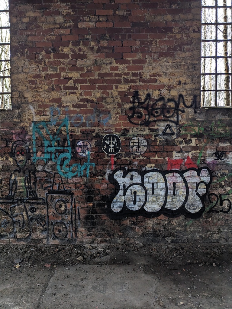
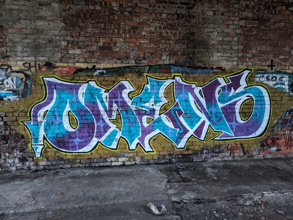


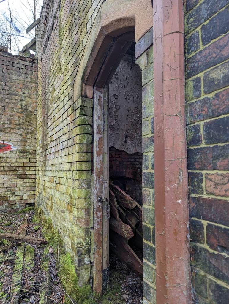


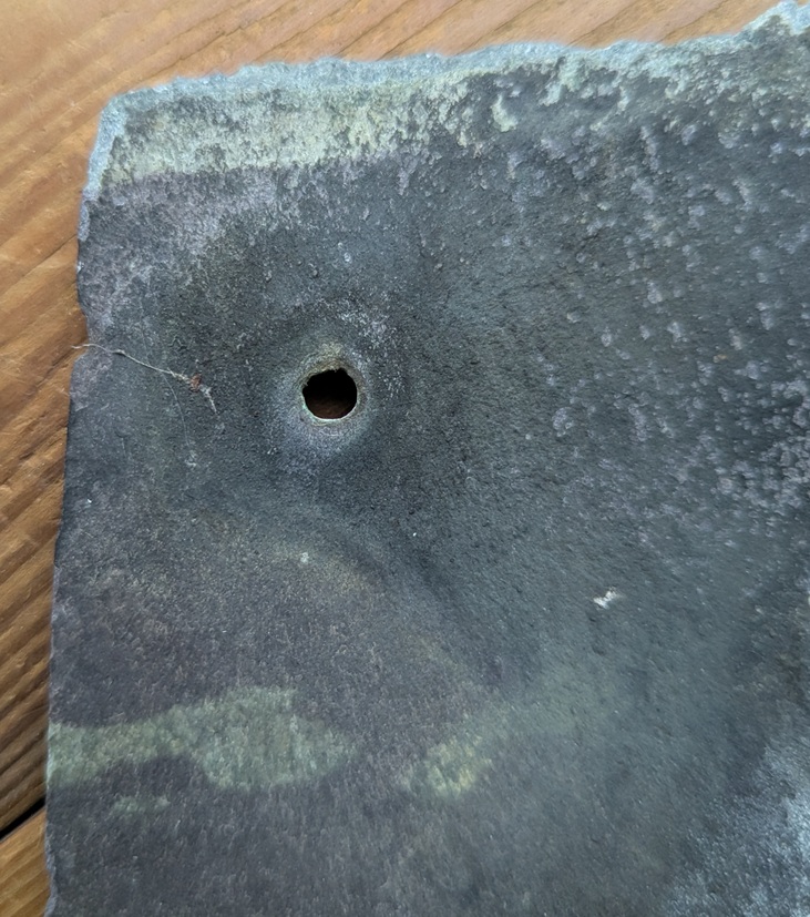


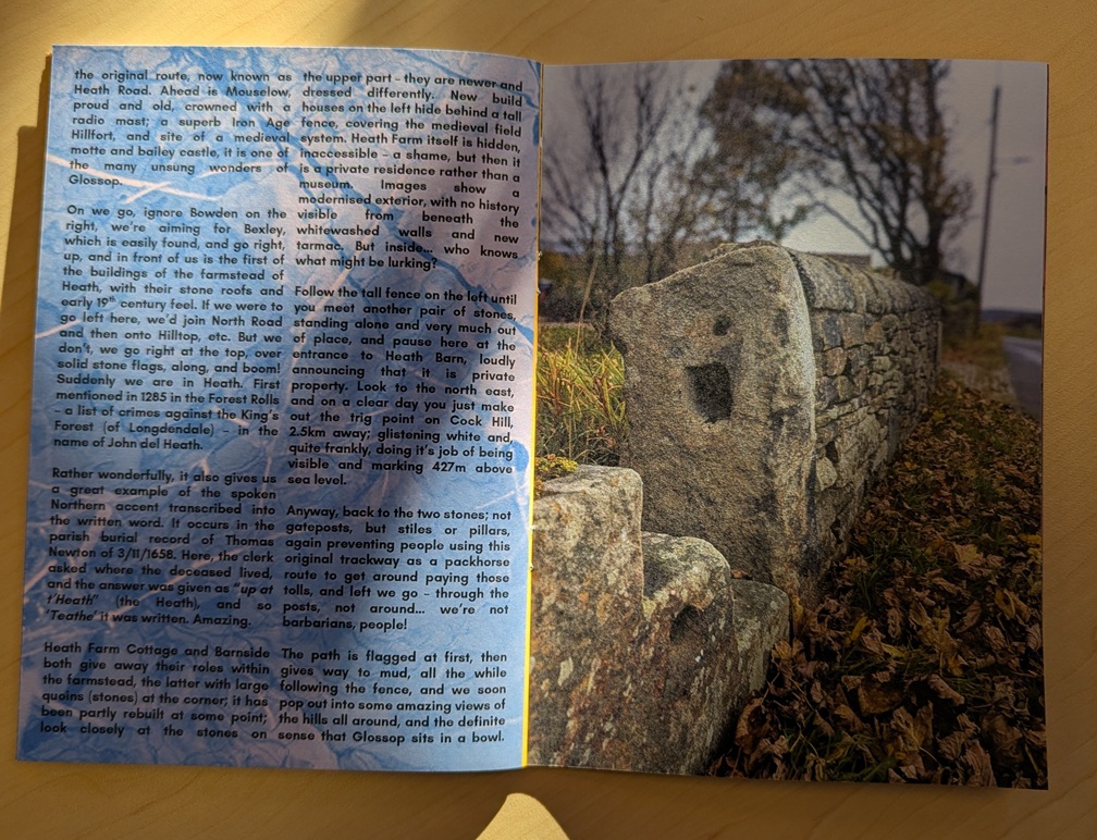


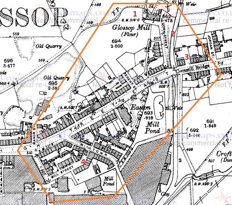
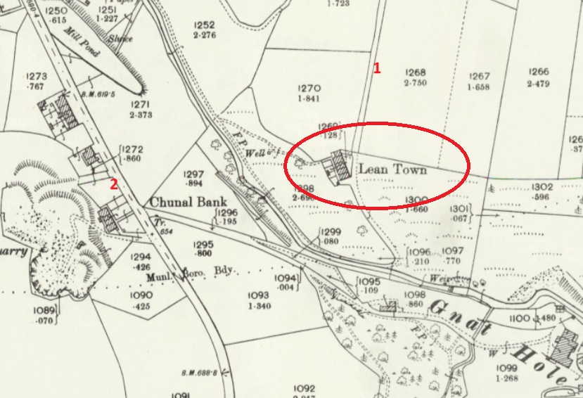
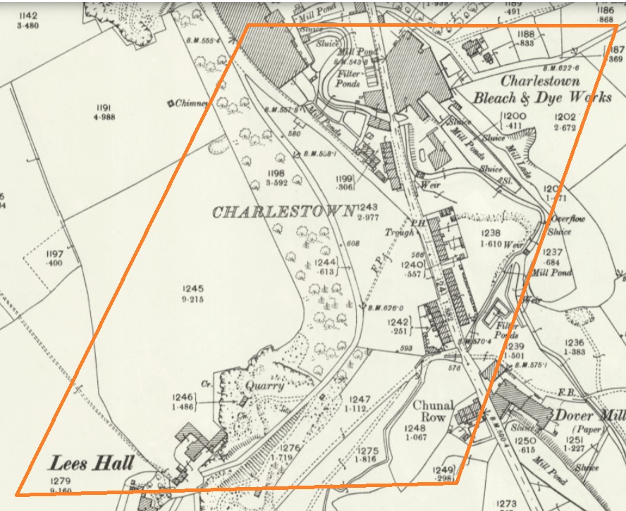
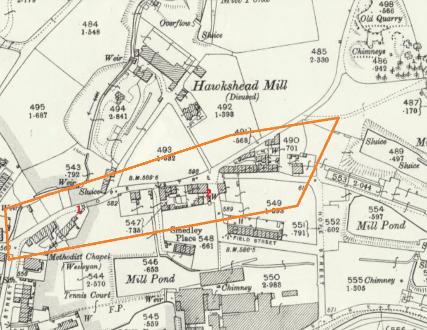
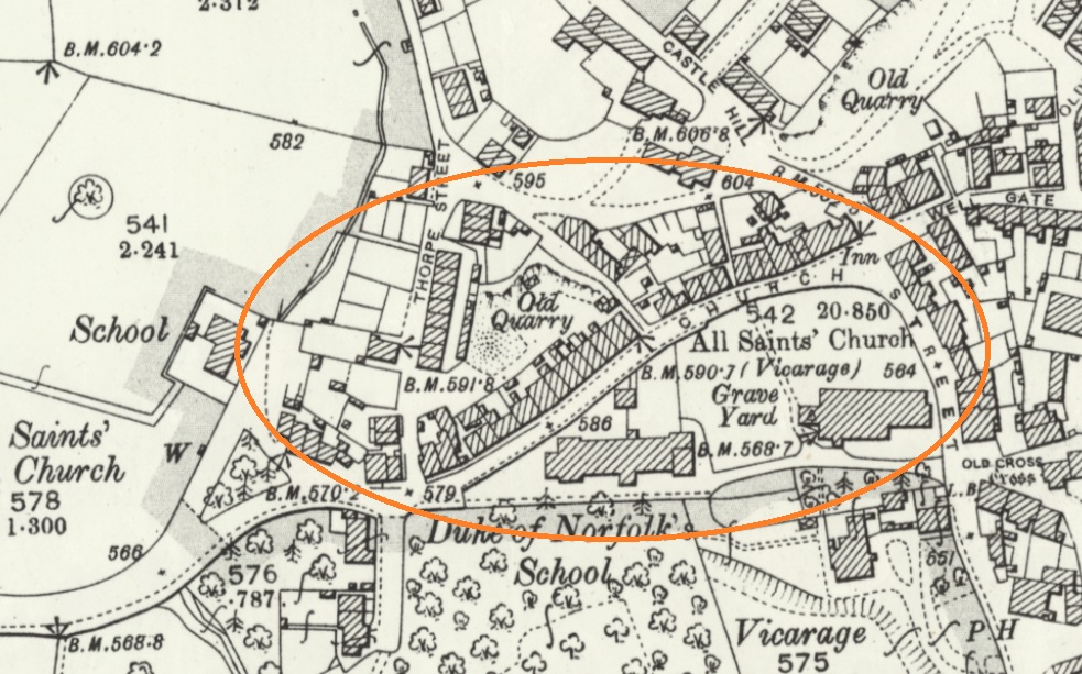
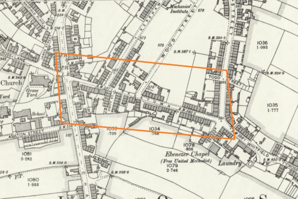
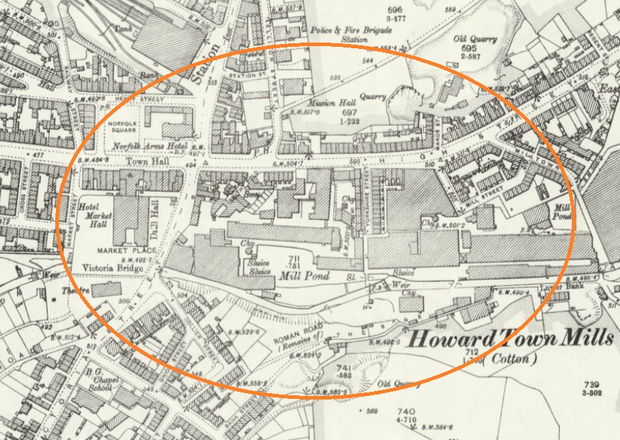
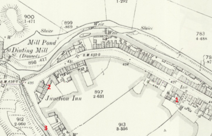


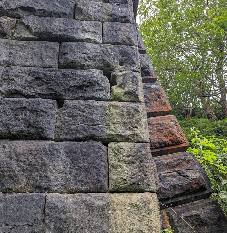
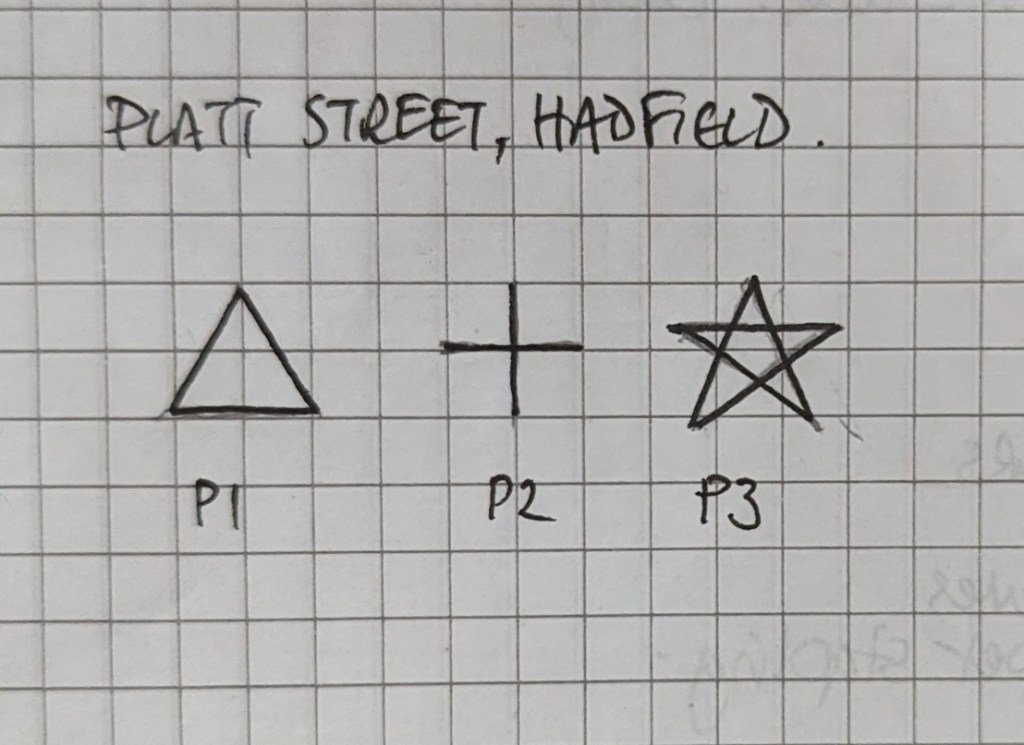

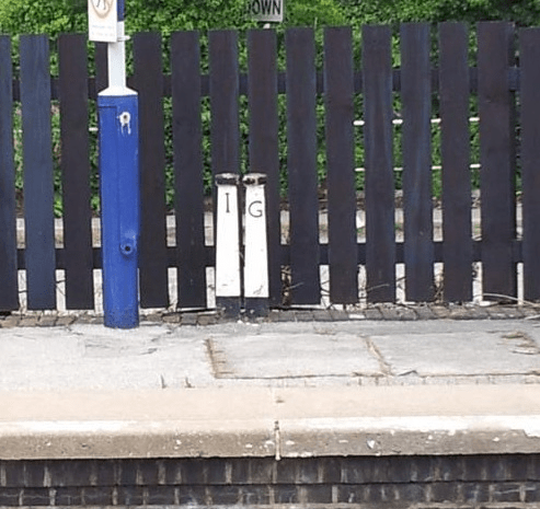


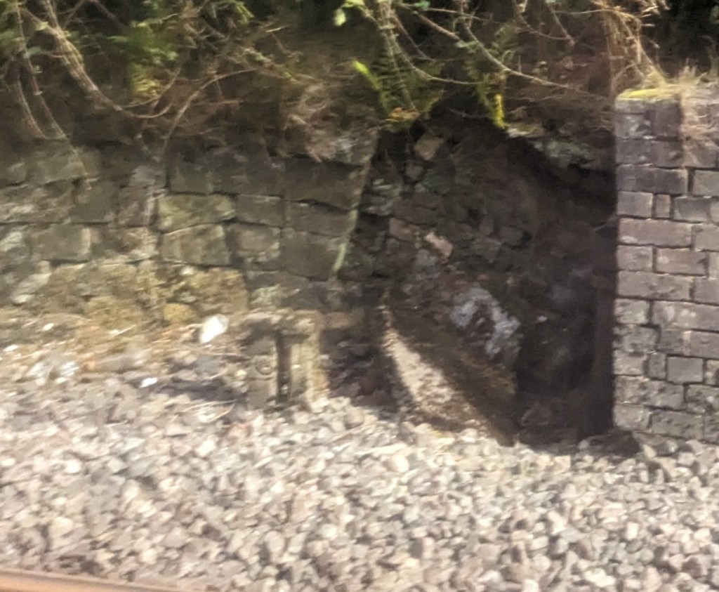
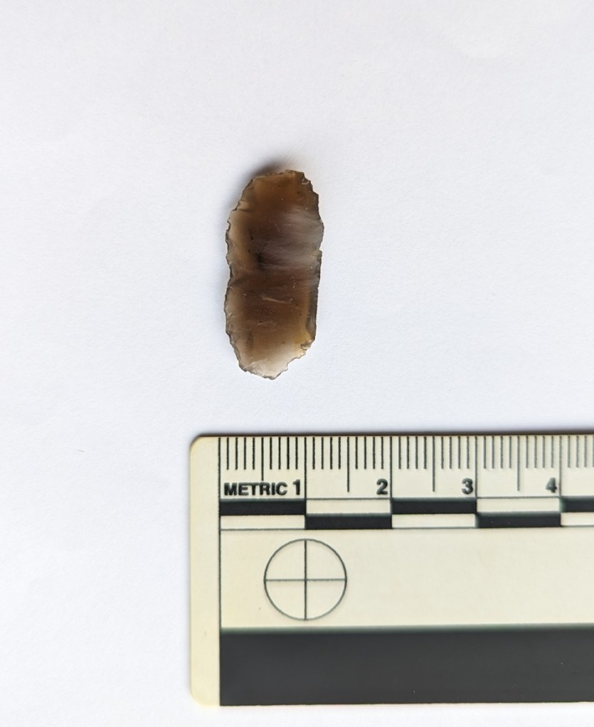


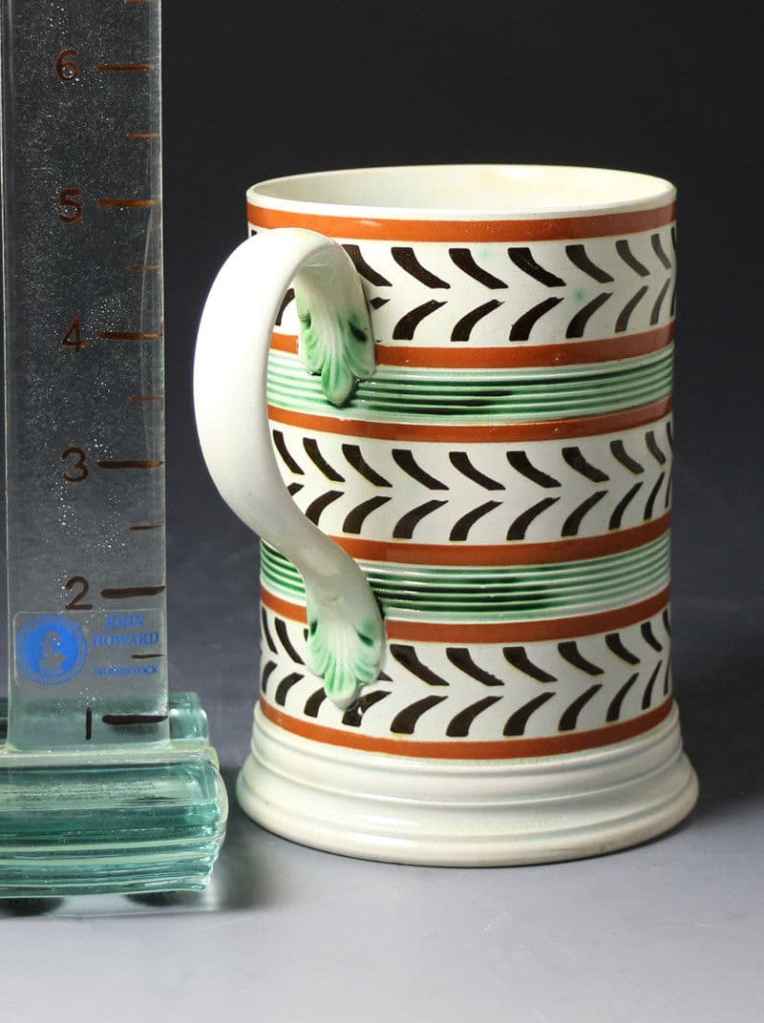
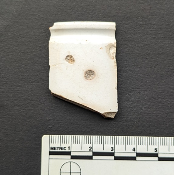


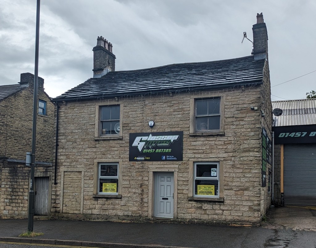

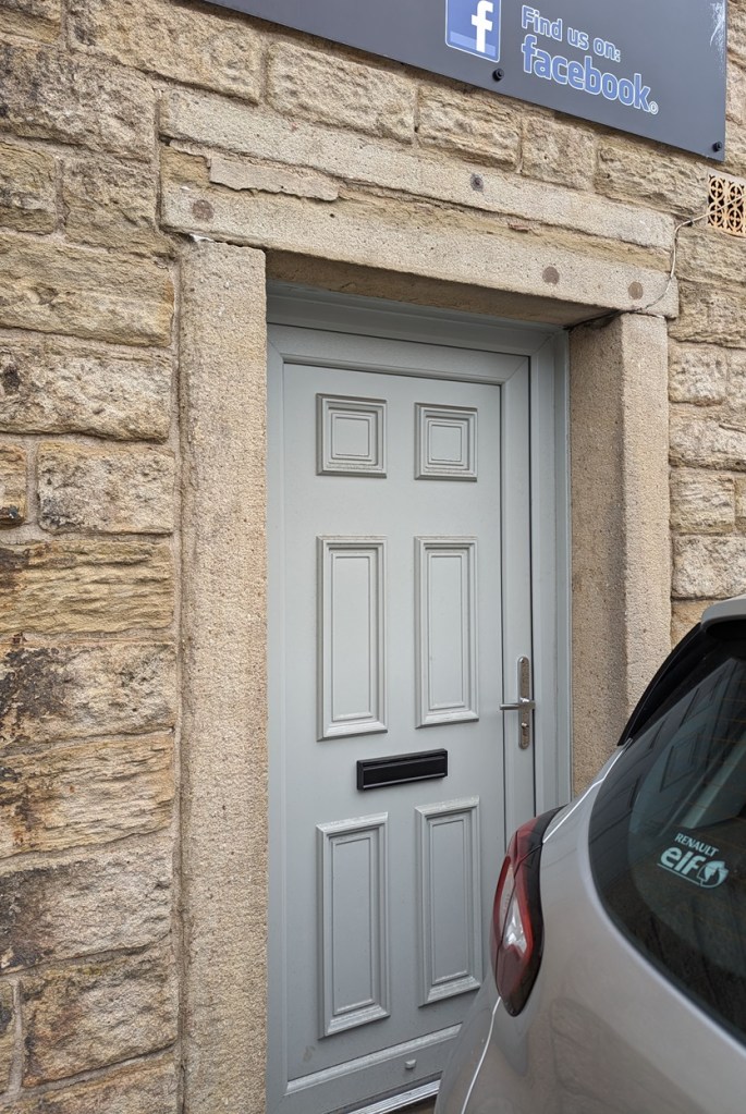


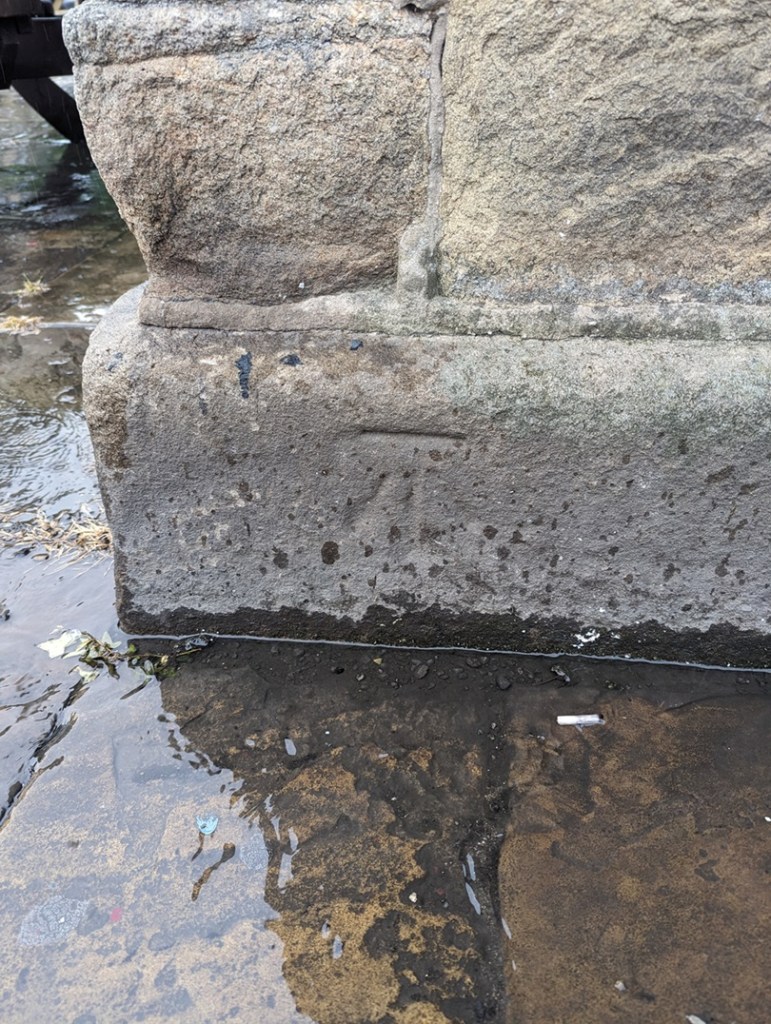


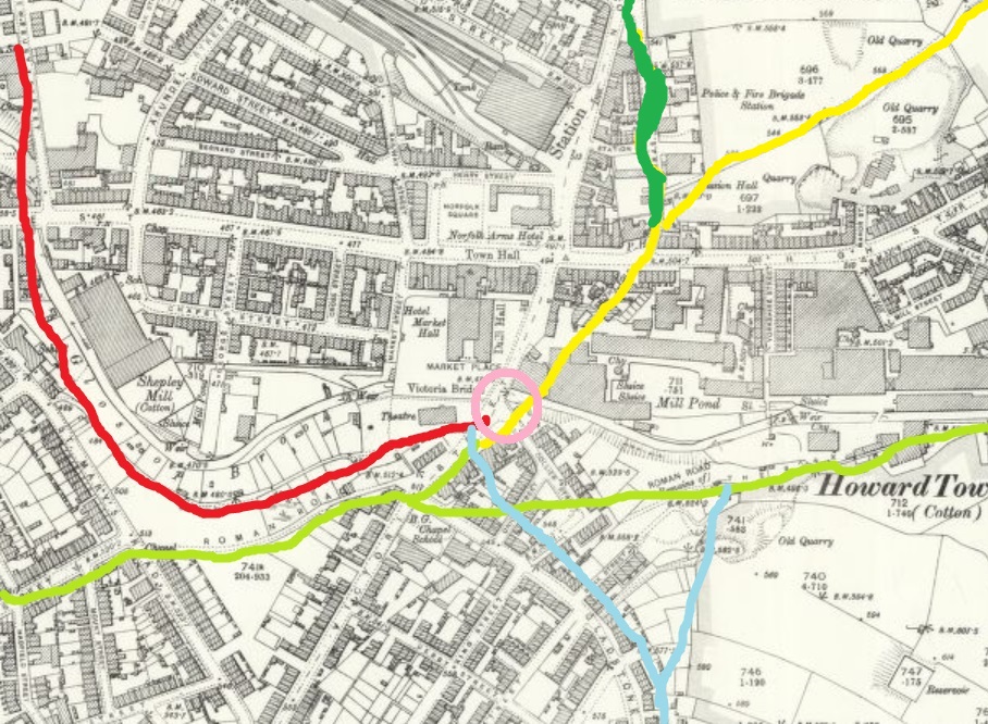


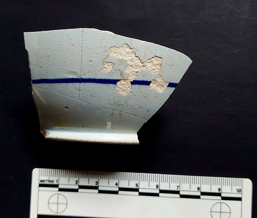


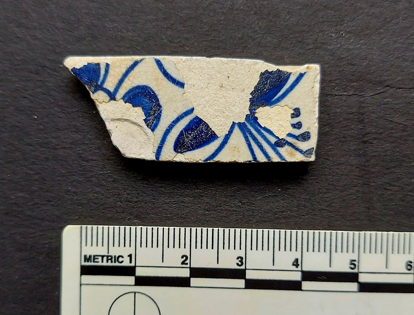


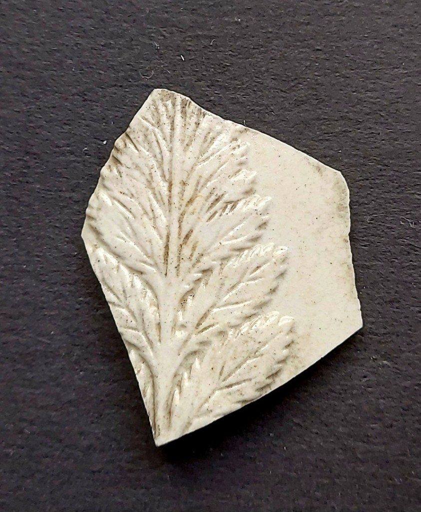
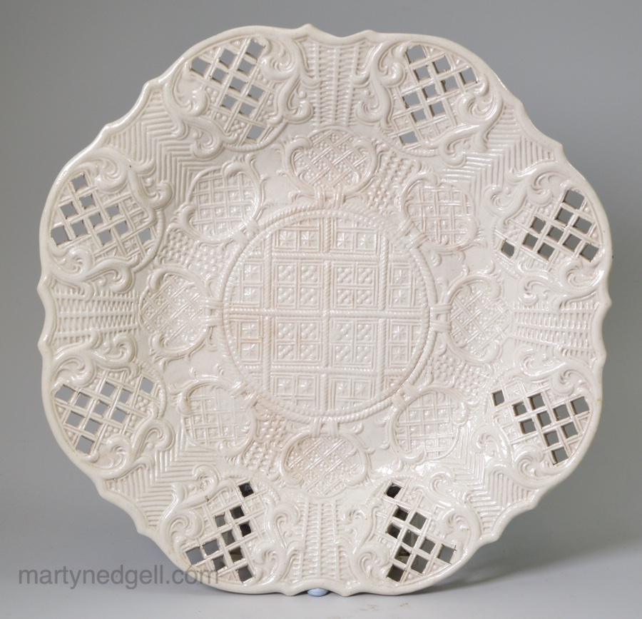

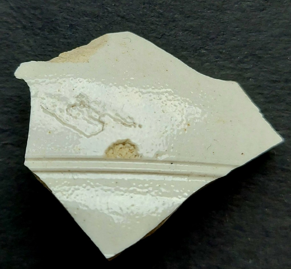


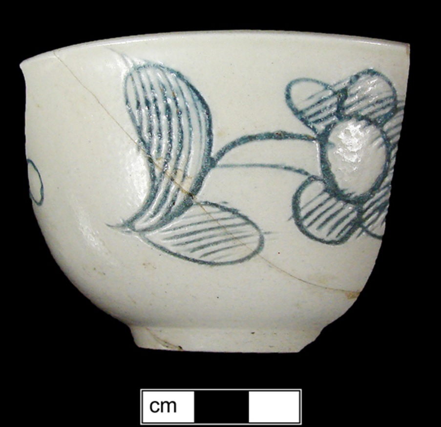


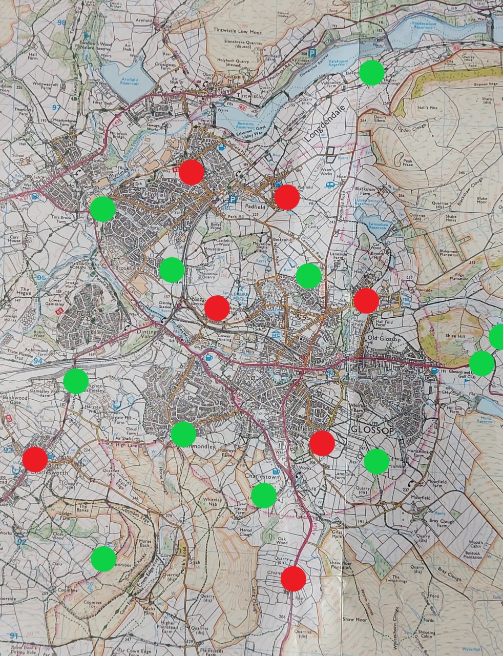


