Archaeology · Bench Marks · Mason's Marks · Where / When

Marking Time

What ho, wonderful, and slightly odd, folk of the blog reading sort. I hope you are all as well as can be expected, and as we move into autumn, you get out an about as much as you can – always keeping an eye open for pottery and other interesting things.

Which sort of leads me to today’s offering. It’s a mixture, to be honest, some updates, some new stuff, but all interesting. I have said before that I always have multiple half-written articles on the go, all moving at different speeds – but for one reason or another, none leapt out at me asking to be finished. So here we are… Marking Time!

I’ve always been obsessed with the idea of humans marking their surroundings, and the notions of permanence, even immortality, that accompany this; from palaeolithic cave art to bronze age cup and ring markings, to 17th century building datestones, to Victorian carved graffiti, to modern tags – and I’m looking here at you, Boof, whose name is everywhere around Glossop at the moment – it all amounts to broadly the same thing: marking time.

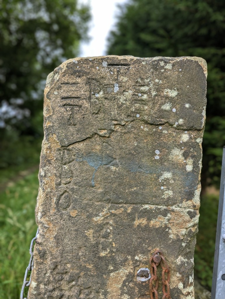
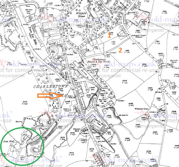
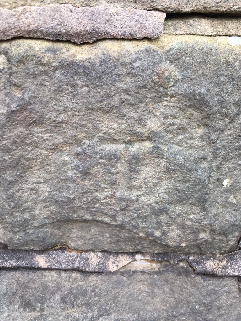
Datestones update: As always, I am on the lookout for more datestones of a pre Victorian date (pre-1837). I recently bagged this:

Herod Farm, Whitley Nab

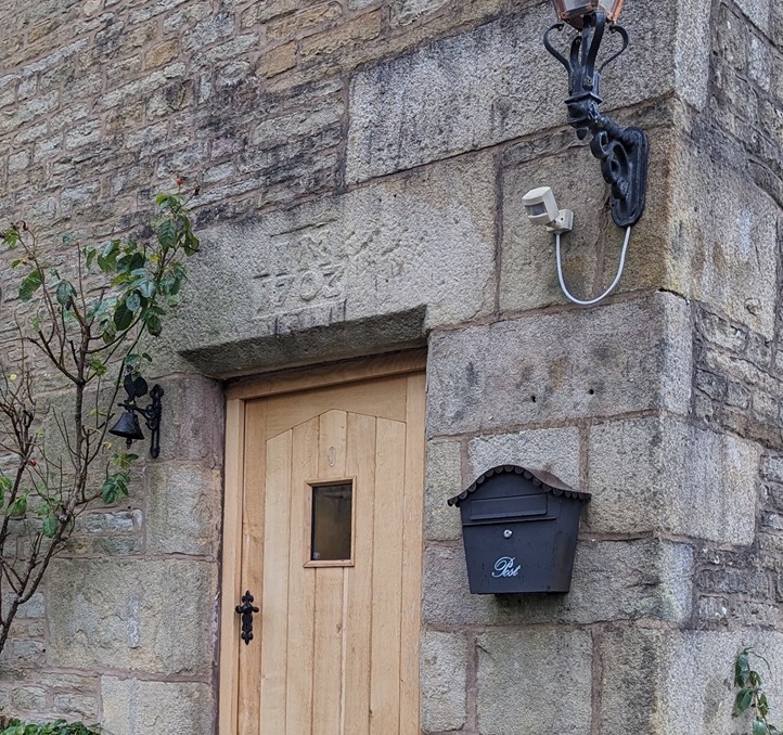
Wonderful – ‘I.M. 1703’ – to the point, although I have no idea who I (or more likely J) M is. I have a whole article about Herod Farm and the surrounding area in progress, but wanted to share the datestone with you.

The always knowledgeable Roger Hargreaves emailed me a comment he tried to post on the site – technical issues prevented it, but here it is:

So there we have it – John Morton, and a teaser about the Lees Hall – a fascinating place, with a long history, and possibly a moat! Well worth an article and more. Thanks Roger, your input is always much appreciated.

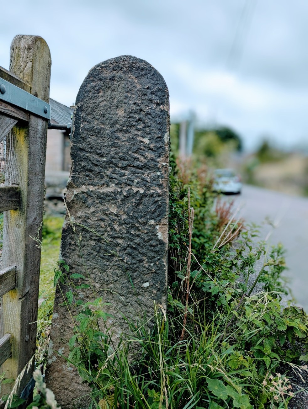
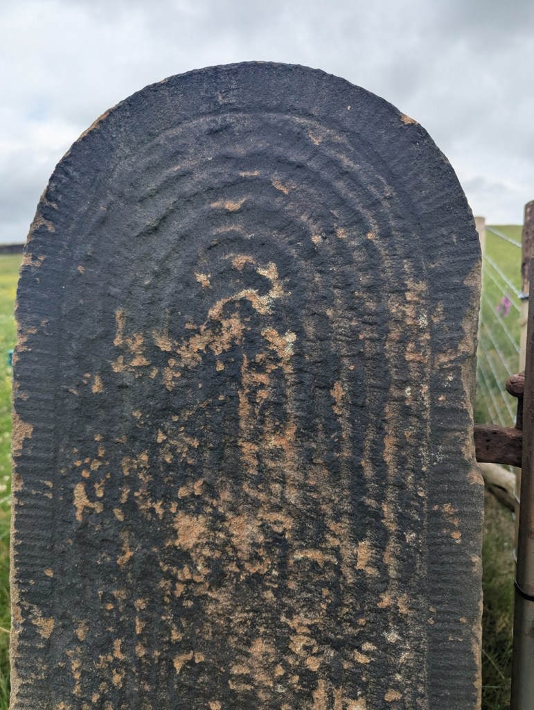
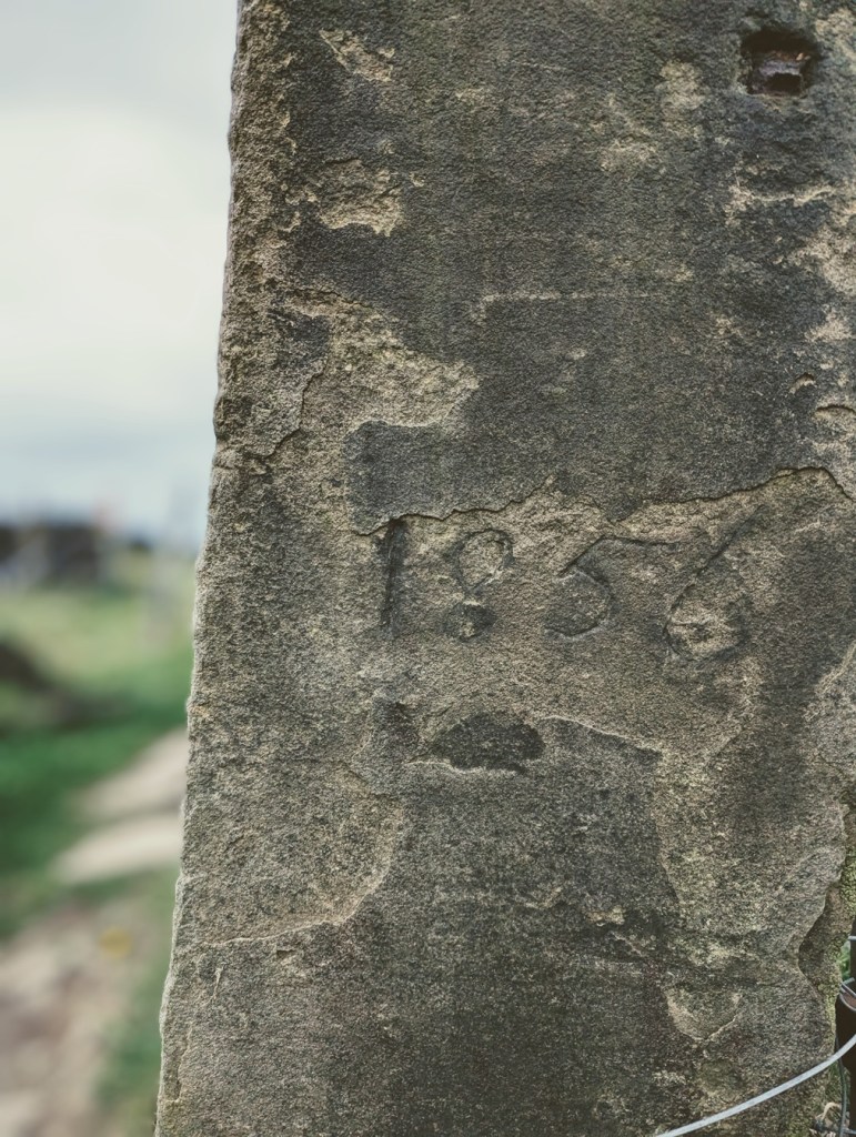
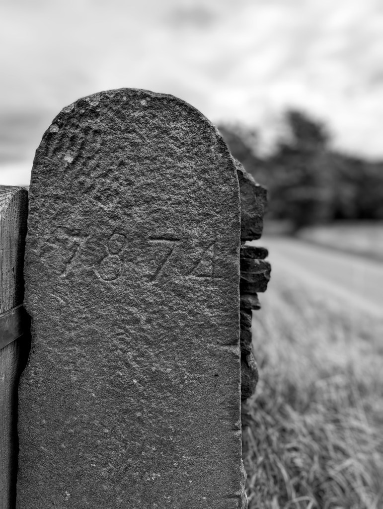
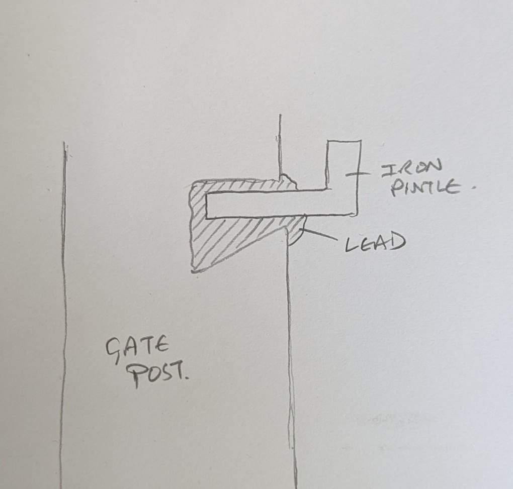
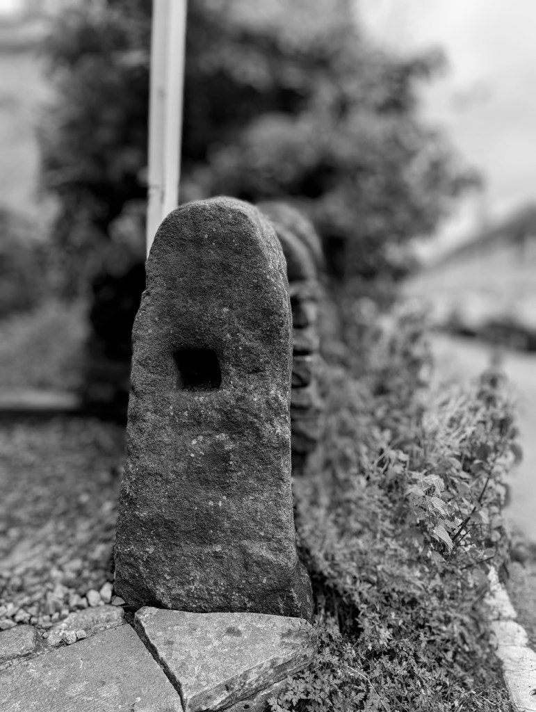
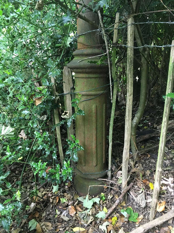
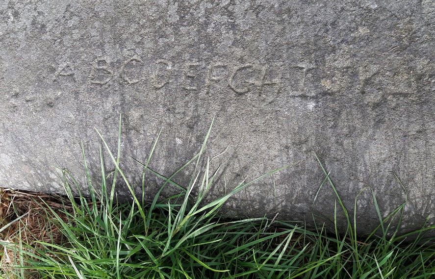
Update to the Gatepost article: We recently bought a campervan, a mobile home with beds and a stove, and all that. It’s marvellous, and is unmissably yellow, or more truthfully YELLOW! (give a shout and wave if you see it around). Our first adventure camping was to Peak Forest, near Buxton, and coming home we decided to take an odd route for the sake of exploration – a vehicular Wander, if you will. Coming through Wheston, south-east of Chapel-en-le-Frith, we came across lots of gateposts, modern and made of concrete, but each marked with initials and dates:

I have no idea who CTH is – presumably the farmer who is replacing gateposts – but I salute your attention to detail – initials and date – and respect your devotion to tradition; earlier, 19th century, examples of dated gateposts can be found here. It might be concrete, but the idea is exactly the same, and I want to buy you, CTH, a glass of the stuff that cheers. Wonderful.

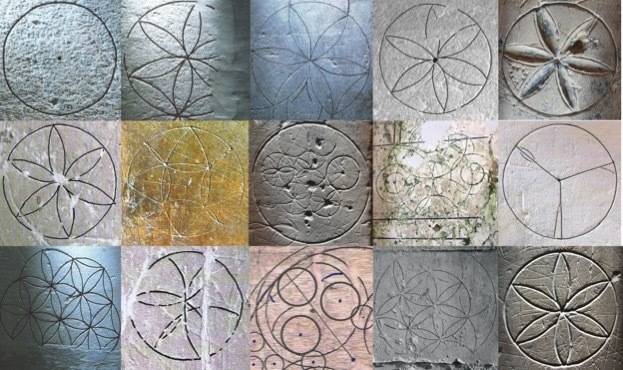
Next we have things seen on pavements… Glossop seems to have inherited the whole street paving slabs second-hand from somewhere. I seem to remember a whole hoo-ha about these stones, and others, occurring maybe 20 years ago – their origin and how much was paid for them… or something. Whatever, but what is certain is that they have some interesting markings on them, and all of these were seen between Costa Coffee and the Norfolk Arms – almost certainly more await discovery, so look down people:

A simple cross, formed of two chisel strokes.
‘1 – 7’ with the ‘1’ formed apparently by three chisel strokes, the ‘seven ‘7’ by three down and two across. No idea of the meaning.
A cross, and a hole filled with a lead plug. It’s difficult to imagine what this large flat stone would need a hole with a lead fixing for – it’s not like it was used for a gatepost or similar. I genuinely cant imagine what or why!

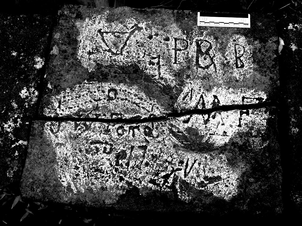
Finally we have this beauty:

Where to start?

So, we have a name in the bottom left, clumsily written – ‘Joseph’ something or other… D? B? Can anyone make out this? The second letter could be an ‘E’. Possibly. But then we have what might be a landscape – the top right looks like a fat sun, drawn by a child, to me. And in the centre, at the bottom, possibly a house (I think I can see the roof and walls, with perhaps a person in it). This is really an enigma – a name, and a piece of art, undatable, and probably from a place far from Glossop… but imagine if we could put a person to it. And all this, lying under our feet.

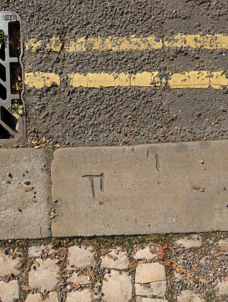
Other bits and pieces under our feet include markings on kerbs:

A simple ‘T’, probably referring to Telephone, and marking where the cable came into a property.

This is also sometimes marked by ‘GPO’ on kerbs, standing for General Post Office who were originally (from 1880’s until 1981) responsible for telephone communications. I once found an example on a kerb on Howard Street, but had not been able to find it since, until I came back from a blood test at the clinic there, and this was picked out of the dark by street lights:

Wonderfully carved, this was, I assume, where the telephones for the train station entered the buildings.
Another ‘T’, but this one in Old Glossop seems to have an errant exclamation mark after it!
Another slightly odd kerbside marking – an ‘E’, which is believe marks the place where electricity cables enter a property. It is quite common, although in this case it is accompanied by an ‘S’ and a ‘T’, the meaning of which I have no idea.

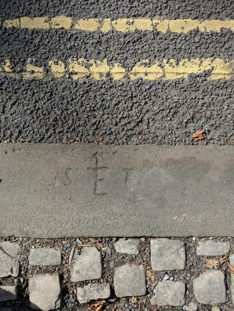
I also saw this on Princess Street – another marker showing where electricity enters a property – this is also quite a commonly found one.

A no frills, very clear and functional, EL!

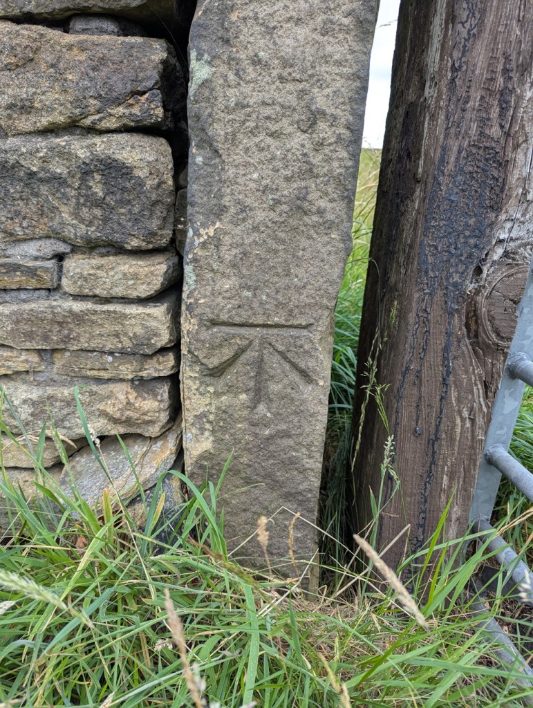
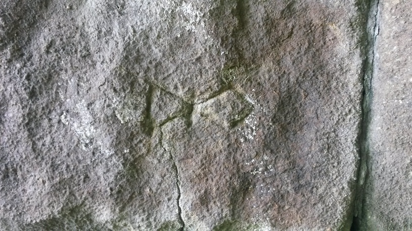
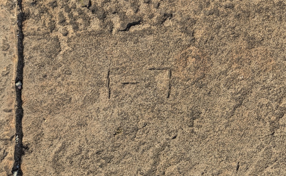
Here’s another mark that is commonly seen: a simple arrow, but not like the Ordnance Survey benchmark arrow, this is normally crudely carved, thin, and without the horizontal line above it… thus:

Literally an arrow, pointing.

This is another of those that points to a service – gas, possibly, or electricity – entering a building, although I truthfully don’t know… any help would be welcome.

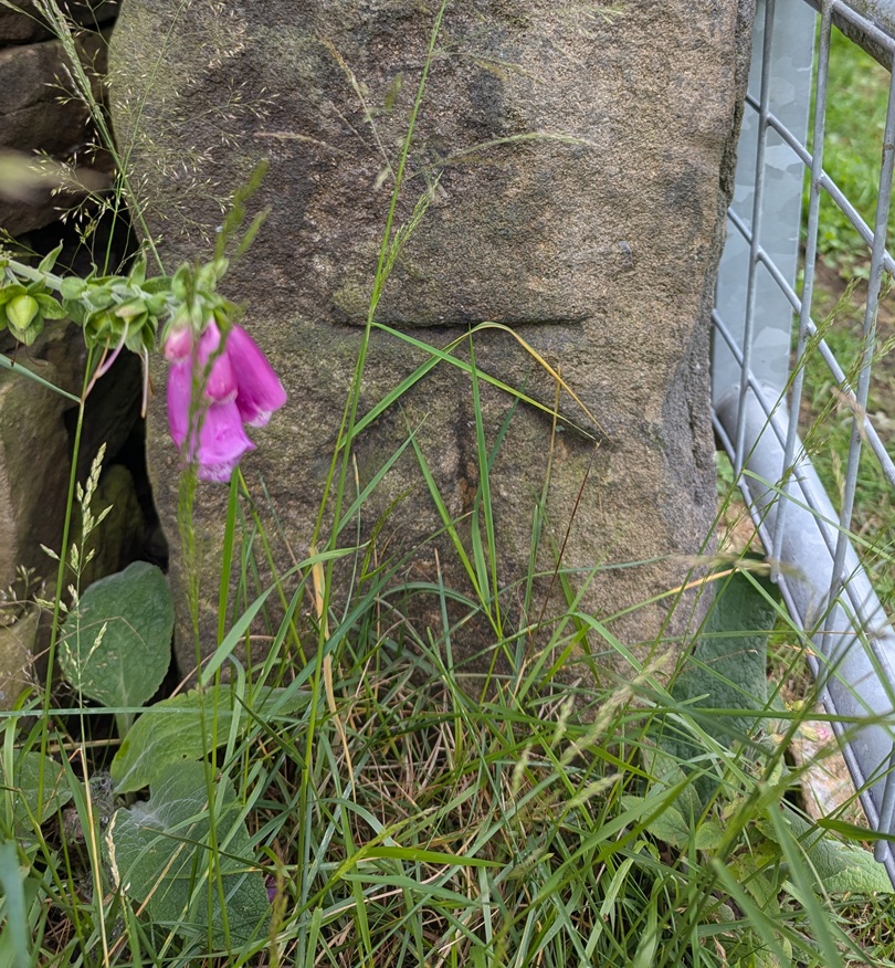
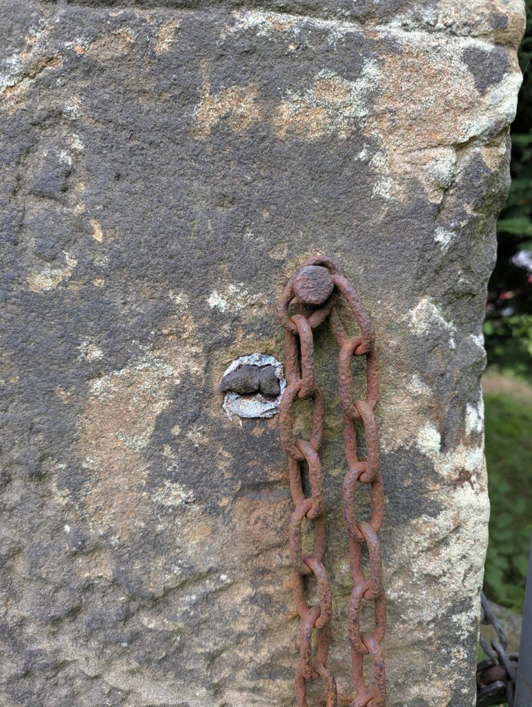
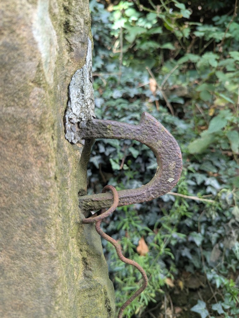
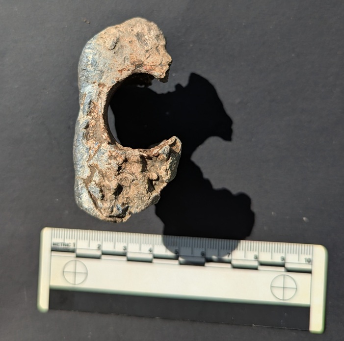
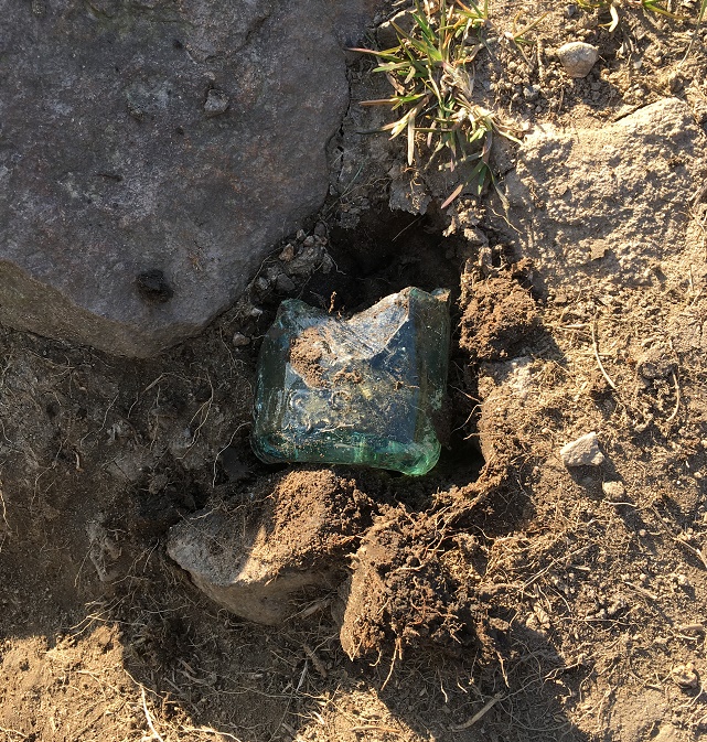
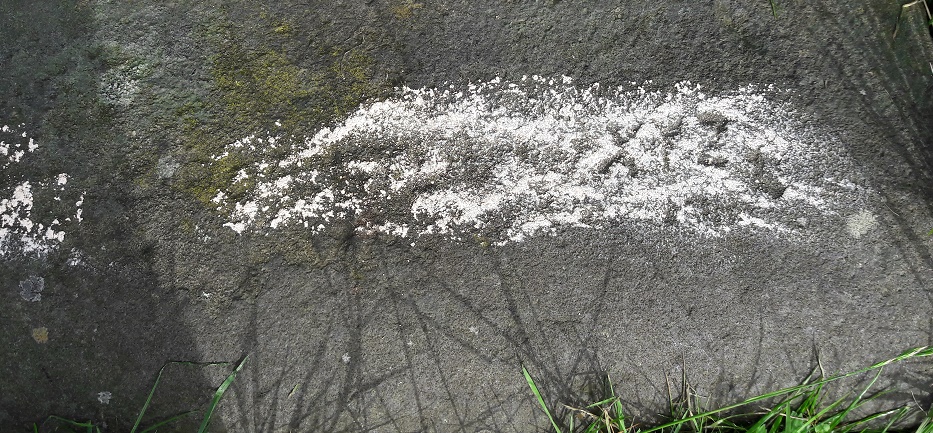
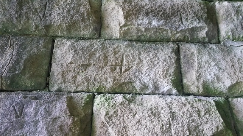
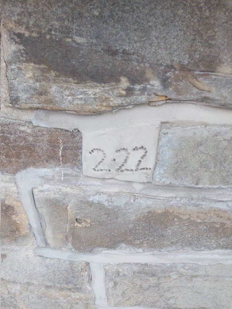
However, here is a Benchmark, newly found by me, under the railway bridge on Arundel Street, and which marks 501ft 8″ above sea level:

Worn, and almost camouflaged, there it is.

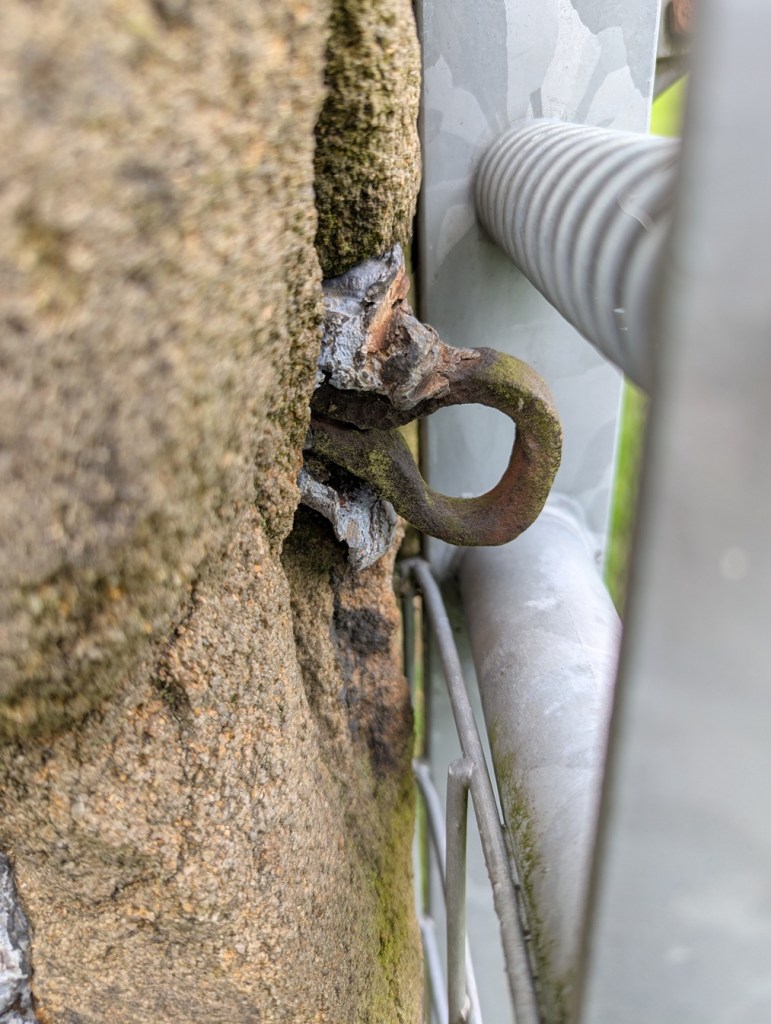
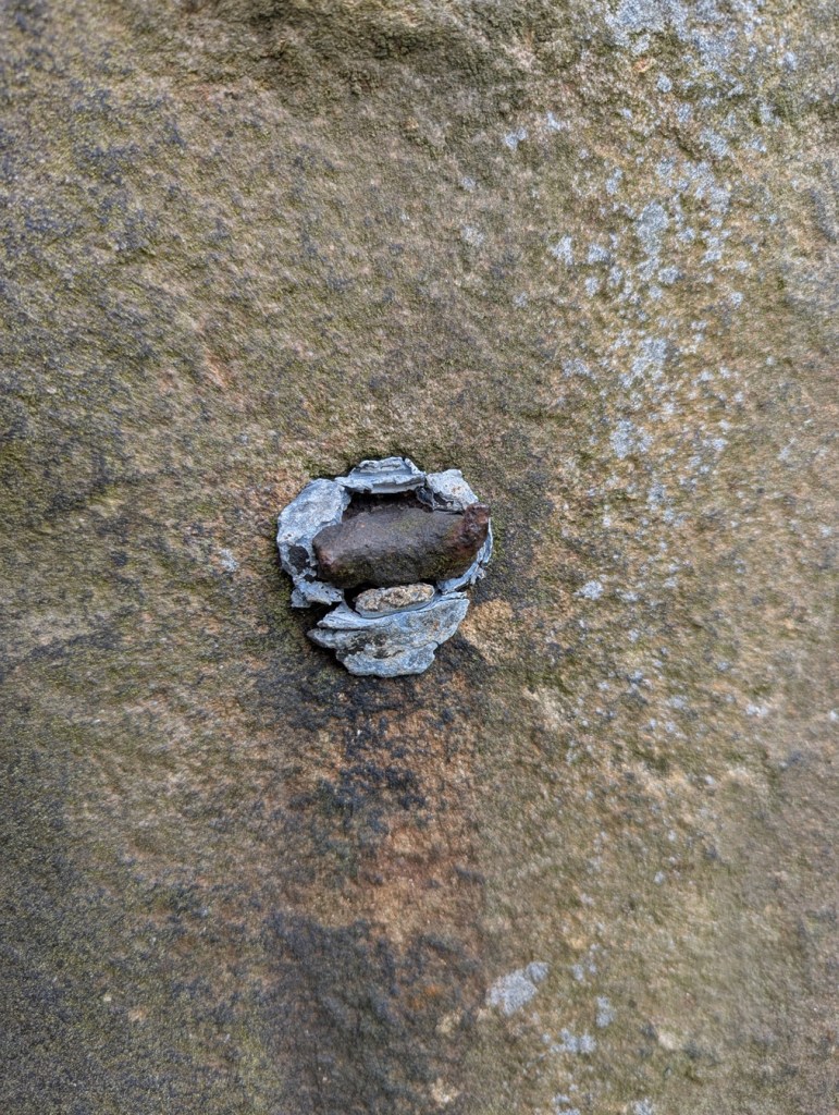
Also on the bridge are these single holes, often found in the upper part of the stone:

And here…

These small, shallow, holes were made in order to use a pincer, or external, Lewis and frame in order to move the blocks. A genius invention, it’s a simple iron tool that, via a chain, uses the weight of the block itself to hold it fast whilst it is moved, and enables even a single person to shift a huge piece of stone. But it requires a shallow hole in order to provide a point that gives a good grip. I love these, as they allow us to view how the bridge was built.

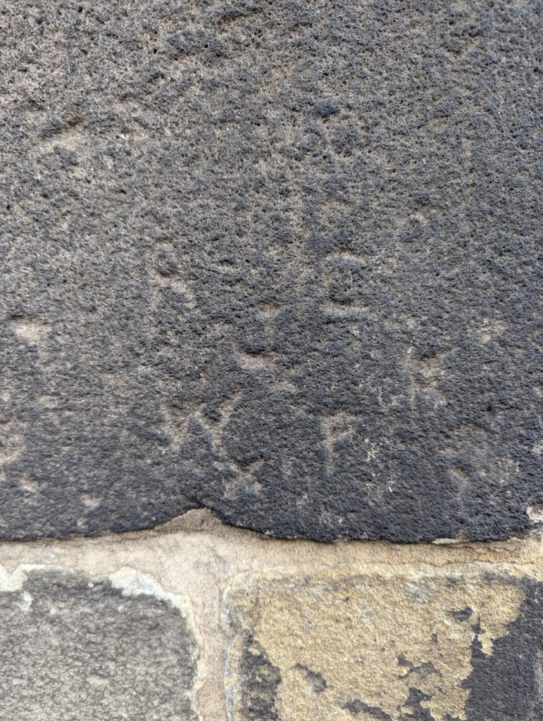
Another example of us viewing the method by which these wonderful Victorian structures were built is this:

Very characteristic.

Often occurring in pairs, these are drill marks made by quarrymen, into the rock face, which allow them to insert a splitter to pry away the stone from the quarry face. Once seen, they are very recognisable, and are the scars that show how, with a little physics and a lot of brute force, rock can be shifted.

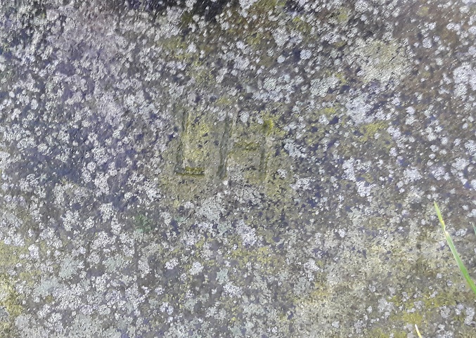
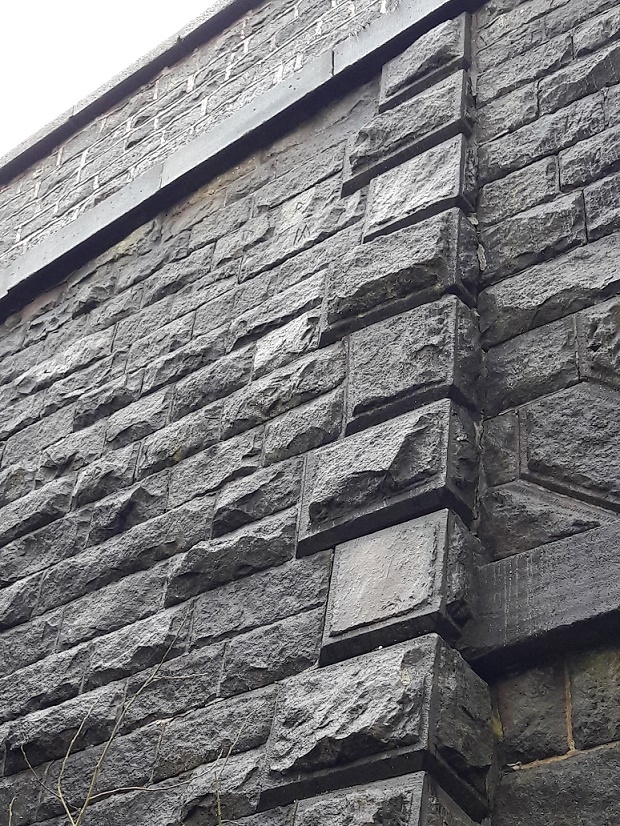
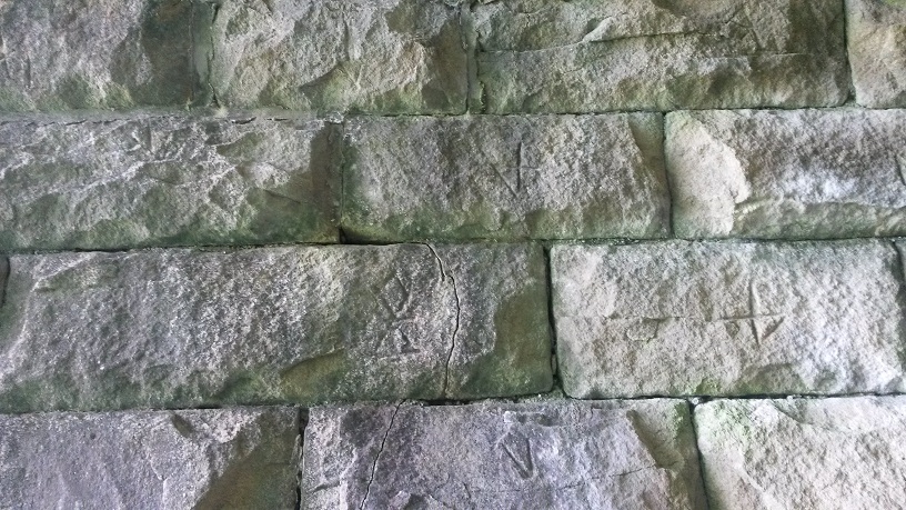
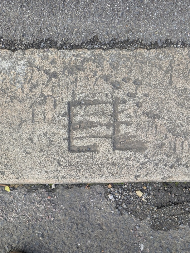
Howard Street, which meets the Arundel Street bridge, has a few, sporadic, mason’s marks along the stretch of railway walling here:

A cross.
A ‘T’.

Low key, and not very common, these nonetheless represent the ‘signatures‘ of the men who shaped these stones. The cross is a common mark carved on stones – it is literally two strokes with a chisel – so it cannot be definitively linked to those masons who built Dinting Arches, but you never know.

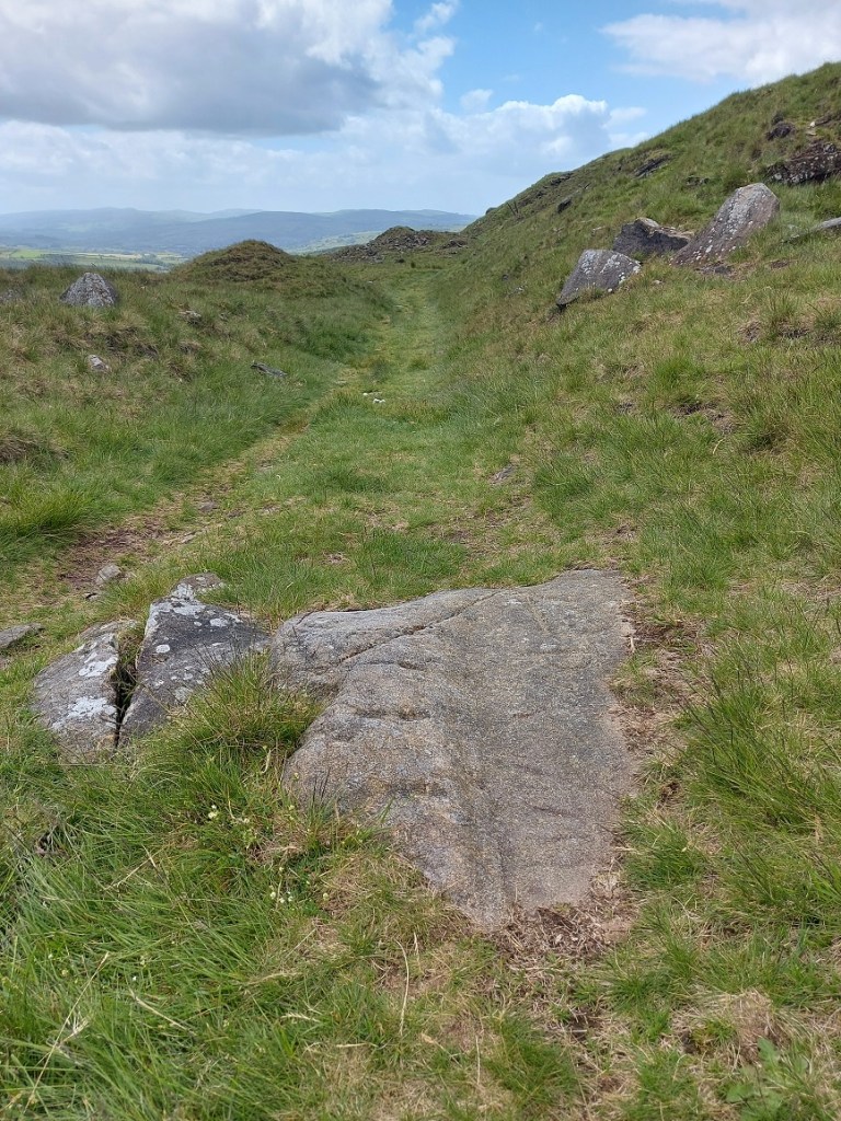
Other mason’s marks can be found around…

A ‘B’, upended.

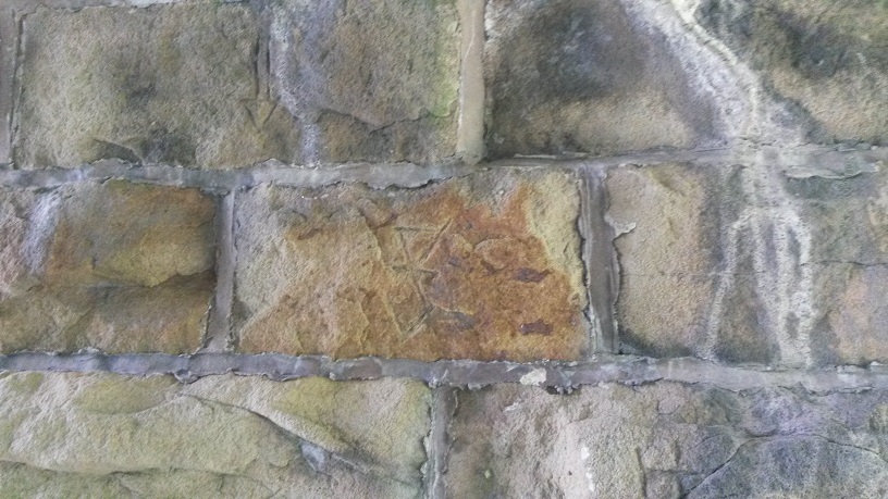
This is found on a lump of masonry from Wood’s Mill, and now stands where Wood’s Mill once stood, now Glossop Brook View, and by the houses there. Post-1842 in date, although possibly early, the mark was hidden until the mill was demolished – the rough dressing of the block indicates that it was never meant to be seen. I wonder who ‘B’ was.

Another, difficult to see.

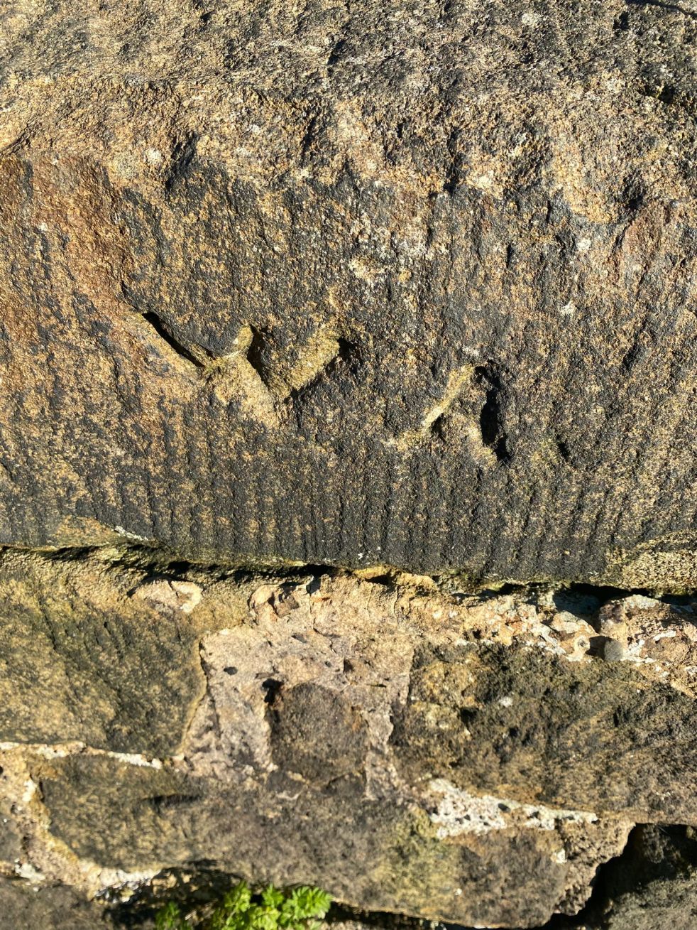
This last one is on the gatepost of the Crown Inn, Victoria Street (although the gates are on Hollincross Lane); very faint – and difficult to photograph – they are in the angular shape of a fish.

I also spotted this on Howard Street:

February 2022.

A dated piece of cement. This is either dated proof of work done – a modern form of mason’s mark – or possibly a dated repair that allows Network Rail to observe cracks forming and assess integrity. Either way, it’s kind of cool!

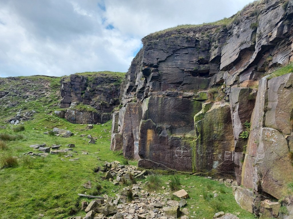
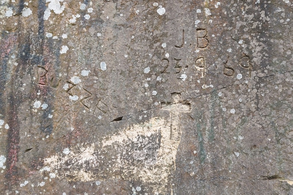
Finally, some bits of carved graffiti, a particular favourite of mine.

A single ‘J’ on the wall of Heath Barn, Heath.
‘S’ ‘H’ on the wall of Glossop Church.
Also on the north wall of Glossop churchyard, on Church Street – initials – R C J W P. The arrangement is odd, and I wonder if they were 4 members of a single family, with the surname ‘J’. That could surely be traced if it was the case!
‘W’ ‘A’ (photo from Suze Hill)
‘W’ ‘G’ (photo from Suze Hill)

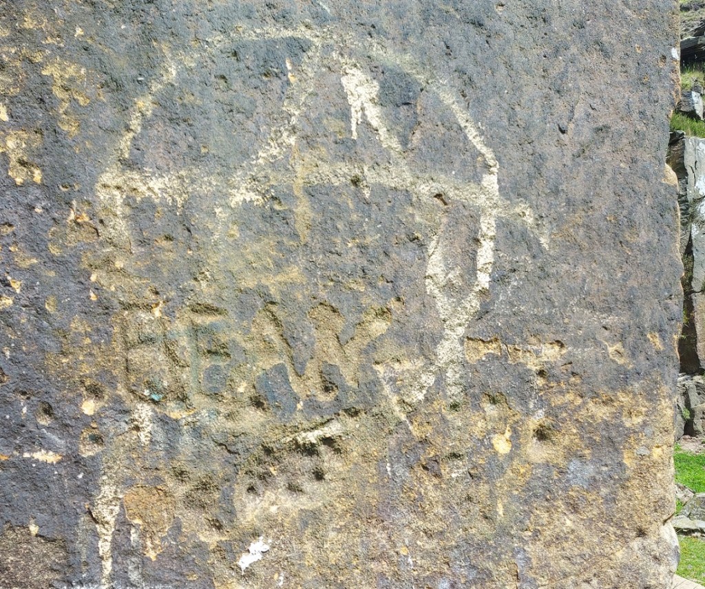
These last two were from the bridge over the Longdendale Trail on Padfield Main Road. The whole bridge has a lot of graffiti carved on it, including this wonderful example:

Old and the new. I love this photograph, and am very proud of it!

Here we have Victorian carved graffiti – ‘J.H’, possibly, along with some more letters, undecipherable under the frost, over an early incarnation of the now famous (infamous) BOOF graffiti tag made with a spraycan. I find it interesting that we would condemn one, but praise the other as historical and interesting. When does vandalism become history and worthy of study? A bigger discussion, and one I find fascinating (akin to when does something become archaeology?). I know graffiti, as in modern graffiti – put it down to a misspent youth and a love (despite appearances to the contrary) of Hip Hop – and I have followed BOOF’s career with a certain interest.

So here I shall leave it. Making marks, and marking time – it’s all about trying to achieve immortality, to leave your mark long after you are gone, and making people remember you, even if they don’t know who you are. I think that’s all any of us, myself included, can hope for. There are so many examples of this phenomena in the Glossop area, and I have an idea to produce a book looking at precisely this sort of thing – watch this space.

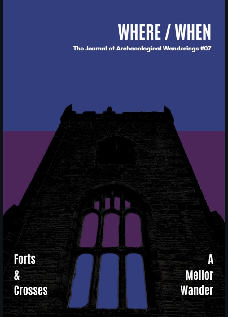
Talking of books, please check out Where/When Number 7 – Forts and Crosses: A Mellor Wander.

This one is a truly awesome Wander around Mellor – just over yonder! It has medieval field systems and farms, Victorian noise, an Iron Age hill fort, medieval crosses, cracking views, a terrifying viaduct, bench marks, a trig point, wonderful gateposts, and it starts and finishes at a pub… what’s not to love? Here’s the cover to tempt you.

Available from the shop, link above, or from Dark Peak Books and Gifts, High Street West, Glossop. Or, you know, just track me down and throw money at me.

Talking of which… if you enjoyed this, and fancy buying me a glass of the stuff that cheers, then please do so via this link to my Ko-Fi page. I do what I do here because I love doing it, and I feel it’s important we explore our shared heritage… but I’ll never say no to a pint in thanks!

So much more news to share, and so many things planned. Watch this space, wonderful people, as big things are coming.

But on a serious level, how are you doing? Genuine question. Personally, I’m a little down at the mo… the devastating loss of my brother (cheers Stephen, I’ll miss you), coupled with a dose of Covid, and the general malaise that accompanies the move from summer into autumn and winter, has meant a lull in the festivities here at CG Towers. Still, the wheel turns, the seasons they change, and life will inevitably continue, and on we go. But as I always say, look after yourselves and each other, you really are important, and too often we say “I’m aright” when we actually mean “I’m not alright, please help” – it’s ok to not be ok.

So then, more coming, but until next time, I remain.

Your humble servant,

TCG

Archaeology · Bench Marks · Graffiti · Standing Stones

Gateposts

What ho, lovely people of the blog world. I hope you are all well as we hurtle headlong into summer, each of us fearing what terrible weather will mar an otherwise splendid season. Nevermind, this too shall pass and all that, and indeed we must grasp the nettle by the horns, or something, and make H whilst the S shines…

Today’s post is one of those brought about by happy coincidence, where a series of events conspire, almost waving at you, until you finally notice and say, loudly, “what ho… a blog post!” Or, in this case, a Gate Post. The first event was posting a few photographs on Twitter and Instagram (@roberthamnett on Twitter, and @timcampbellgreen on Instagram, for those of you who might fancy checking it out). Turns out I’m not the only one who likes a good gatepost or two. And then the next event was my seeing a tiny piece of metal in the soil whilst doing a recce for a Where/When (No.7, to be precise… Of Forts and Crosses: A Mellor Wander). All will become clear, honestly.

For years now I have been obsessed with gateposts. Mundane, utilitarian, and always overlooked, a good gatepost can be as interesting as a prehistoric standing stone to me, and truthfully, there is often very little difference: both made of stone, both standing upright, both important in the past, and also in the present. And if anything, gateposts have more interesting features! I mean, obviously prehistoric is fascinating, but they don’t really give us much to go on, whereas the later gateposts… well, read on.

They can be decorated – often just roughly dressed.

A simple rough dressing, to shape it in a uniform manner.

But sometimes some thought has gone into them, to create a pleasant design – which for a utilitarian functional object seemingly goes beyond what is needed.

A simple cross, surrounded by a border. I say simple… it takes some doing.

I mean, the only time you see the gateposts is when you are opening a gate to let sheep or cattle in and out, and it’s probably not something you’d see everyday. And even if you did, it’s only for a moment or two, it frankly doesn’t matter if it looks good, and I doubt farmers are wandering around making snarky comments about the plain decoration of another farmer’s gateposts. So why? What is the purpose behind them? I don’t mean they had some sort of secret meaning behind the decoration, rather they simply represent someone’s choices, but why those choices I wonder? Possibly it’s probably more to do with pride in the work taken by the stonemason who shaped it, perhaps a form of identifier: we know it’s person X who shaped it, as he always decorated it with a cross. But then there are those that go beyond simple decoration, and instead turn it into a work of art.

This is wonderful! The way it shifts from the upper band with a circular motif, to the lower aspect with the herringbone pattern is amazing. A lot of effort went into this.
This too, is truly wonderful. The circular motif, with a border, is just amazing. This post seems to be in the reddish Cheshire sandstone, which makes sense given that it, and the last gatepost was found in the Mellor area, rather than Glossop.

Other times, we find words and dates on gateposts. Often these are faded and barely legible, the weather and environment are not kind to these solid sentinels, and they have no shelter.

‘1856’, on the track from Fieldhead Farm to Whitfield Cross.
I went all arty with this shot… I’m quite proud of it! ‘1874’ in a very similar hand to that of the above gatepost – I wonder if it was the same person? This is on Kidd Road, just before its junction with Derbyshire Level.
Multiple ‘B’, ‘D’, and ‘O’ – from a post just by Fieldhead Farm.

The Ordnance Survey often use them to carry benchmarks – after all they’re not likely to be moved, and so are a safe and permanent marker for heights above sea level.

The line above the arrow is 682 ft above sea level, precisely.
This one is 716ft 2″ above sea level.
I love this photo… the grass almost mirrors the benchmark. Oddly, I don’t have a height for this mark – for some reason, no OS map I have come across shows its existence. Strange.

The fixtures and fittings of gateposts always fascinate me, too. Cast iron hoops and hooks, held in place by the tell tale grey/blue of lead. Sometimes you can only see the lead, the actual latch or pintle missing, it’s function no longer having purpose – it is just now a standing stone.

A now missing something or other, the metals eroding, staining the stone. It can get so bad that it actually kills the moss and lichen.
More something or other, now missing, but once important. The lead fixing is a tell-tale sign that the iron whatjamacallit is missing. I honestly love this, it really does show my theory of objects having a biography.
This is lovely… beautiful cast iron eyelet, twisted and shaped whilst red hot, and then held in place with lead. Although no longer needed to make the gatepost function – the modern steel gate does that (leaving it’s own scars on the stone) – it remains a part of its history.
Multiple phases of use, each leaving a mark.
Again, scars, but once meaning, purpose.
Hand made, and truly wonderful.

It was actually one of the lead fixings that I found that partly inspired this post. I saw what was obviously lead sticking out of the ground, and bending to remove it as I always do – it’s really not good for the environment – I realised it was bigger than I expected. I studied it for a moment trying to work out what it was, when suddenly: “aha” I thought “that’s a fixing“.

You can see rust on the inside, where the iron whatsit was held in place.

Looking at this lump, and using a small diagram, you can see what it is and how it worked. The long hollow through the middle once held the iron fixture – a pintle or latch, perhaps.

The iron whatsit was circular in section.

The shape of the lead piece is also a clue to how it actually held this in place. A hole is made into the side of the gatepost that needs the ironwork on it, with the lower part of the hole made deeper. The ironwork is placed in the hole, and the molten lead poured in using a funnel to hold it within the stone and around the iron whilst it cools.

If this makes sense.

When hardened, it forms a plug that is very difficult to move, keeping the iron work in place; clever, and elegantly simple. It’s also nice to see the ‘inside’ of the gatepost, or rather a cast of the inside, and one wonders why the lead has come away so intact from its original home – one can only imagine that the post itself was broken, freeing this fixing, which then found itself at my feet in the wilds of Derbyshire years later.

In terms of dates for these gateposts – well, it’s not clear. I think the more uniform stones, with a rounded head, are Georgian and Victorian – later 18th and 19th century. However, there are some that I think are significantly older – 17th, 16th, even 15th century, possibly. These are generally less formally worked, are shorter, and importantly are characterised by having a single straight hole through the stone a few feet above the ground.

Another arty shot, this one of the ancient gatepost on Hague Street.
Carrhouse Lane, Whitfield. And no, I didn’t stick my hand in the hole…

I was, until fairly recently, convinced that these were marker stones for trackways, the square hole perhaps taking a wooden pointer. However, I started to notice that this didn’t always fit the pattern, and despite multiple blog articles, twitter posts, and it even published in Where/When, I began to doubt this explanation. I then received an email that pretty much confirmed it for me (thank you PB, you amazing man!). In it, the author quoted a John Farey, whose 1815 book – General View of the Agriculture and Minerals of Derbyshire: With Observations on the Means of Their Improvement. Drawn Up for the Consideration of the Board of Agrigulture [sic] and Internal Improvement – gave the following quote:

Anciently, the Gates in the Peak Hundreds were formed and hung without any iron-work, even nails, as I have been told; and some yet remain in Birchover and other places, where no iron-work is used in the hanging: a large mortise-hole is made thro’ the hanging-post, perpendicular to the plane of the Gate, at about four feet and a half high, into which a stout piece of wood is firmly wedged, and projects about twelve inches before the Post; and in this piece of wood, two augur holes are made, to receive the two ends of a tough piece of green Ash or Sallow, which loosely embraces the top of the head of the Gate (formed to a round), in the bow so formed : the bottom of the head of the Gate is formed to a blunt point, which works in a hole made in a stone, set fast in the ground, close to the face of the Post. It is easy to see, by the mortise-holes in all old Gate-Stoops, that this mode of hanging Gates was once general.

Of course, it made sense, despite me banging on about them being marker stones. So, please accept my apologies for this; I am not always correct, and my knowledge is always growing. And thank you PB, who brought this to my attention – this is your discovery, not mine (you can read the book here – P.92 is the quote. There are about 20 of these gatepost types I know of, with many more awaiting discovery. And I actually think these are quite significant, as if we plot their location on a map, we might get a better grip on land use in the pre-industrial period. Marvellous.

I am obsessed with gateposts, and I want you to be, too. Everytime I pass one, I check it out, and often I am rewarded with some nugget of information, graffiti, decoration, or just a blast of the past. Let me know what you find via the contact page, and let’s keep an eye out for those holed ancient stones.

Right, I think that’s all for this month, and lucky you the next post will, I suspect, be a pottery post! Woohoo! I have found lots of cool stuff recently, and it all needs writing about. As always, I have about 30 projects ongoing, not all of which is coming to fruition anytime soon, but some will emerge relatively rapidly – watch this space. In the meantime, do please check out the Etsy store, or the Ko-Fi page – and feel free to buy me a beer coffee, or yourself a copy of Where/When, or even a t-shirt!

But until next time, please do look after yourselves and each other. I know I always say that, but you all matter, and we all need to take better care of each other… the world can be scary place at times, so lets band together and help each other.

And as always, I remain.

Your humble servant,

TCG

Archaeology · Graffiti · Stones of Glossop

Naked Ladies… and a Quarry

Well that got your attention! What ho, wonderful people! What ho!

Up by Coombes Edge lies Cown Edge quarry. This quarry, long disused, contains a number of interesting, and oddly well executed, carvings on the walls. I have heard about this particular place – and its carvings – many times, and from many different people, but had never managed to get up there. No reason, simply that there are so many places to see, and so little RH. A few months ago, a friend (my thanks to Andy T) suggested a walk up that way and, well, I thought, let’s have a look.

What I like about this place is not just the ‘historical’ history, which is visible and tangible, but the ‘personal’ history which is similarly visible, but often better felt than seen. The quarry seems to be one of ‘those places‘; a destination, a space in the landscape that attracts; a shelter, an asylum, a place of freedom, and perhaps decadence. In particular, it’s place where ‘youths‘ go and be ‘youthful‘, frolicking, feeling, fumbling, and… well, you get the picture. I didn’t grow up in Glossop – I’m a ‘comer-inner‘, so to speak – but if I could take you to Cheadle Hulme where I did grow up, I could show you a few such places from my youth. Every town & village has them – and the similar stories they could tell of the first time drunk, illicit substances consumed, virginities lost, love discovered, best friendships forged, fights fought, and the always difficult transition from child to adult negotiated – often on the same evening. But perhaps most importantly, memories are made. To quote Wordsworth “Bliss it was in that dawn to be alive, but to be young was very heaven“. I have recently turned 47 (young for some of you, old for others… it’s all relative), and have been marvelling at the swift passage of time, so forgive the nostalgia. Now on with the show.

Cown Edge Quarry seems to have been started sometime in the early 19th Century, probably as a source of roofing stone. Geologically, the stone is Rough Rock – a type of sandstone of the Peak District and southern Pennines, and the most commonly occurring of the Millstone Grit group.

Incidentally, and as a rule of thumb, you can roughly date the buildings of Glossop by what the roof is made from. Prior to c.1850 roofs were made from stone taken from local quarries such as these. However, once the railway arrived (c.1850) Welsh slate could be imported on trains. Not only was slate cheaper, but it also weighed less so the roof could be constructed using less timber, and so roofs after 1850 tend to be made of this. A rule of thumb not an absolute guide, but useful nonetheless.

Anyway, the quarry is located here:

Thank you Google for the image.

And here it is in 1898:

And thanks to the National Libraries of Scotland for this image.

If you use the What Three Words app, the reference for the quarry entrance is: tribal.workers.crossword

Now, as subjects go, it isn’t perhaps the most interesting, but then as we know on this site more than most, ‘interesting’ is a veeery subjective word. However, it was deemed important enough to have its own Historic Environment Record – MDR10021. Largely overgrown now, and with none of the urgency and noise that would have marked it out as a place of work when it was operating, it is peaceful and still.

The view looking north from the quarry mouth
Looking west. Interesting, and a little odd, to think that the roof of my house, where I type these words, was almost certainly quarried from this place.

However, the walls are full of interesting graffiti, carved over the years since the place was abandoned. Some is more worthy than others, but all is a record of people, humans being, well… human. I have said elsewhere that there is something universal about the need to leave a mark on the environment, almost a way of achieving immortality, your name living on past you, perhaps. And hats off to those who did it before the invention of spray paint… if you wanted to put your name up in the past, you had to mean it – with a hammer and chisel. Here follows a sample of the carvings – mundane, as well as the more creative.

AKW 1942 – presumably there is no reason to lie about the date, so this is interesting… and asks further questions.
“Tim. Joey. Glossop”?
“.D” – quite modern, I suspect, and a worn hole.
“BEAN”? and some pock marks. These overlay – and are later than – the painted anarchy sign.
“DUF, LEZ, ANT, GUS” 1994. “KEV” at the bottom is even probably even more modern.
“DAN”, “SID”, “LES”, “LYNN”, and some symbols. These seem to have been carved and re-carved.

Talking of symbols, there are what seems to me an unusual number of Christian crosses carved here:

“BUZZB” and “JB 23.9.69” I love this one – the date is so specific. The cross is also very prominent.
An ancient Egyptian Ankh symbol – quite old (filled with slow-growing lichen), and odd to find on the rock face.
Another lichen-filled cross.

Perhaps it’s the crosses that give the quarry its reputation for Satanism and witchcraft? Anyway, the ‘religious’ iconography culminates in this, what the HER calls “a potential Calvary figure” – that is, Christ on the crucifix:

Well executed, and subsequently highlighted in paint.

This is a weird one – is it one figure, or two – a smaller, more feminine and naked, between the Christ-like figure’s legs? Or is it three? The more I look, the less I know. Is that the point? Is there a point? Even down to the almost-altar like outcrop of stone in front of the figure, this is very good.

It seems that this is a modern(ish) rendering, done by a known person – I have heard several different reasons and accounts – and people – but the story is not mine to tell, nor is it for me to name names. That I will save for the comments section, should anyone wish to do so.

However, it looks like it was the same hand that carved this naked lady, as well, so I’m not sure about any religious motivation as such:

It’s carved with skill, too.

There’s also this lower half of a person on their hands and knees.

Not sure what I can say about this… so I’ll say nothing!

Moving away from carvings, and back onto the safer territory of history and archaeology, there are traces of the original purpose to which the quarry was put here and there amongst the more modern intrusions.

The rough dressing is visible in the dark area of the quarry face.

Here we can see the rough dressing of the stone, done prior to it being broken out of the rock face. This provides it with a flat-ish surface before it is smoothed properly elsewhere. This was probably the last thing that was done in this quarry before it was shut down, as it is part of the quarrying process, but was never finished. I like that.

The quarry road, with spoil piles on the left.

The quarry road is very nicely preserved, but if you look closely at the stone at the bottom of the above photograph, you can see a groove worn into the rock there, running top to bottom. This is the track of a sledge repeatedly being drawn over the stone, day in, day out, for decades. A horse-drawn sledge is easier to use, more stable, and less likely to cause accidents, than a cart, and were often used in these remote quarries.

I also found also a concretion in the rock face of the quarry. Essentially, a concretion is a small boulder of one type of rock which is formed naturally, and which becomes trapped within the matrix of a surrounding rock when it was laid down as sediment millions of years ago.

I love that the concretion looks like an eye, the ‘eyelid’ accentuated by the red paint.

The concretion erodes at a different rate from the surrounding material, and so they stick out quite clearly. They’re fairly common in this type of Rough Rock, as indeed are plant fossils, apparently, but I didn’t see any of those… I need to go back.

Right, there you have it. More soon – including more pottery, you lucky, lucky, people. I’ve got so many ideas – walks, books, tours, blogs posts, pottery workshops, YouTube shenanigans, surveys, excavations, art, creativity, etc. – and so much I’d like to do. For now though, stay in touch and follow me here, or on Twitter (@roberthamnett), or even on Instagram (timcampbellgreen). Or just come up to me and say “What ho, Robert Hamnett!”.

But until next time, please look after yourselves and each other.

And I remain, your humble servant,

RH.

Archaeology · Pottery · Whitfield

A Possible Pair of Post-Medieval Paths, a Potential Pub, and Plenty of Pottery.

As I have said many times before, I do love alliteration. What ho! and all that. I trust you are all keeping well in these odd times? Well, now this is a monumental post – it is precisely three years to the day that I made the first post on this blog (you can read it here if you want). When I first started it I had no idea what it was going to be, other than I had some interesting bits and pieces that I wanted to share, and which I thought other people living in Glossop moght be interested in. The blog is still pretty much that in aim – bits and pieces – and I was right… there are lots of you out there who seem to enjoy the ramblings of a man who gets excited by bits of old rubbish. So thank you, you wonderful people, for reading, and here’s to many more blog posts. Now, on with the show. RH

During the lockdown, Master Hamnett and I have been taking a daily constitutional up and around what has become known as the “secret passageways”. Overgrown and wild in places, even for a man of modest size such as myself it is a mysterious place, but to a 4 year old it is indeed another world. Naturally, I have been keeping an eye open for bits and pieces of history, and I think I have a story to tell. Possibly. Well, I certainly have some pottery to show, so there’s that!

The route we walk is essentially along Hague Street, down one track to Charlestown Road, along, and then up another back to Hague Street. We often continue on and round if it’s not raining, but always walk these paths, which I have helpfully marked Tracks 1 and 2 on the map below:

M6
Tracks 1 & 2 at the top. Ignore the arrow and a circle for now… all will become clear!

The tracks and immediate area are more clearly shown on the 1968 1:2500 map

m10
It’s a nice and short circular walk, if anyone fancies it.

The tracks are interesting in themselves in that they are once again an example of what I call the fossilisation of trackways – they are older tracks that no longer perform a function as such, but are preserved as footpaths. Certainly in this case as it makes no sense to have two tracks mere metres apart going between the same places. Instead, I think they are preserving the memory of a single older track, which I suggest below is Track 2, potentially the more interesting of the two. But I’m getting ahead of myself.

Track 1 runs down the side of this house, which was originally a pub called the Seven Stars (hence the sign on the door frame, although the sign above the door is a mystery… if you are reading this and own the house, could you tell us?).

M7
The one-time Seven Stars pub – I always feel a bit weird photographing people’s houses, but this is visible from the road, so it’s not as though I’m sneaking around gardens.

I know nothing about this establishment, but it was probably a beer house. As a reaction to the widespread and dangerous consumption of cheap gin – the so-called ‘Gin Craze’ of the late 18th century – the government encouraged more beer drinking (beer being considered relatively healthy) by allowing householders to open up their houses to brew and sell ale. These private houses became known as beer houses, and the individual paid a small fee to the local magistrates in return for an annual license allowing them to sell beer, but not the wines or spirits that the normal pub or inn could. If anyone has any information about the Seven Stars, please do get in contact.

Just here is a series of upright stones presumably placed to stop horse riding or cycling. The gap between them is very thin; I might have put on a little weight during lockdown, but even I had to squeeze through.

M22
Breath in!

Carved onto one of these uprights are the intials ‘M.D.’ – I must have walked through these 100 times and never noticed the letters before, but the light and the rain were just right this time.

M23
And as you all know by now, I can’t resist carved graffiti.

Further down the footpath I noticed a reused quern or grind stone – possibly Victorian, but I suspect earlier – being used as a coping stone for the wall. And why not? It’s the perfect shape, and may well have been hanging around for centuries after being used to grind wheat into flour.

M9
The worn central hole is visible, and it’s possible the other half is around here somewhere.

About halfway down, you come face to face with more of those upright stones, although in this case I can only assume they were put there to stop a headless horseman! Honestly, they are quite unnerving.

M19
Not at all creepy and gravestone looking. Nope. Absolutely not.

The path continues:

M18
Master Hamnett on the final stretch down to Charlestown Road. At the end of the path, in spring, there is a truly spectacular spread of wild garlic.

Until we arrive at Charlestown House, and the Charlestown Works that were – now demolished and awaiting houses.

M30
The site awaiting re-generation. The hairpin bend where Charlestown Road meets Turnlee Road is visible. Whitley Nab in the background right, Casa d’Italia left (very nice pizza, highly recommended). Dead ahead is Lees Hall, which is important… stick around!

So, here’s the pottery:

M3
A small assemblage of fairly typical Victorian bits, with a potentially earlier piece.

Top row, from the left: a base of a saucer or small plate; a huge chunky handle belonging to a large jug; a base of a glass jar or jug, or possibly from a tankard – it’s nice and decorative, but not expensive. Next is a fragment of a pedestal footed drinking cup, which is again fancy, but not especially expensive, it being just glazed earthernware. Then there is a rim to a large plate of some sort, being about 30cm in diameter.

The lower row from the left: a fragment of a stoneware bottle, a chunk of a pancheon, and a fragment of a manganese glazed jug or similar thick walled vessel. Then we have two pieces of blue and white earthernware, and a base of a tea cup. There is nothing massively interesting, and it all seems to be Victorian in date, as we might expect… except for the manganese glazed jug! This is, I think, earlier – perhaps early 18th century. It’s quite characteristic, and although there was a revival of manganese glazed pottery in the Victorian period, this glaze is of relatively poor quality, and the fabric (the actual clay of the pot) is quite rough, both of which suggest an earlier date. Then there is this lovely bit of pot; it’s a china dove, shaped to fit onto what would have been a tasteless Victorian jug or bowl – you can see the flat bit where it was joined to the vessel it flew away from.

M4
Found lurking below some dandelions.

Then there was this:

m20
A bottle top

A screw bottle top, probably from a beer bottle or similar, and dating to the early 20th century. I love these things, and have blogged about them previously – here, for example. Unusually, this one doesn’t have the drink makers name or logo on the top, just the name of the bottler – R. Green of Leigh.

M21
Always nice to see.

Moving on to Track 2, there is a noticeable difference between the two. This one is more of an actual track; it is certainly wide enough to drive a horse and cart down it, and it seems to have had a surface at some stage. It is also deeply worn in places, which can be suggestive of an older trackway.

M26
Possibly worn by traffic, the track is quite deep in places.

M27
It’s not much to look at, but this is the surface of the track.

I’d love to put a trench across this track to see how it was made up.

Further on, it has what seems to be a late 19th or probably early 20th century cast-iron streetlight, which is interesting and spookily out of place now, but suggests strongly that it was used as a ‘proper’ track until fairly recently.

m24
It has seen better days, but there it is, slowly being overtaken by nature.

m25
I can’t work out if it is gas or electric… further research is needed.

Right next to the streetlight is a gateway into a seemingly random field, and a benchmark on the gatepost – it’s been a while! This one – 616.77 above sea level – is a late addition as it is only marked on the 1968 1:2500 map. There was another benchmark marked on the opposite side of the track – 622.6ft above sea level – but it’s long gone (you can see it in the map above).

m13
The bench mark. This is what 616.77ft above sea level looks like.

The track continues until daylight is reached.

m32
I love this shot… artful (courtesy of the iphone filters, not talent on my part). Mrs and Master Hamnett providing the scale.

The top of the track, where it joins Hague Street again, is the site of the original Whitfield Methodist chapel – it is visible on the 1880 1:500 OS map:

M28
The chapel is clearly marked.

Built in 1813, it had seating for 200 worshippers, and at one time was the home of the pulpit from which John Wesley had preached in New Mills (as discussed in this post). There are more details about the chapel on the Glossop Heritage webpage.

It was demolished in 1885, and the site is now occupied by a private house, but there are some interesting re-used stones on the trackway which almost certainly came from the chapel. The one indicated by the arrow in particular seems to have been a window frame – originally it would have laid upright, and you can see where the wooden frame was bedded in, and possibly a cross bar set into the stone.

M29
I love Microsoft Paint!

A closer look reveals what might be a mason’s mark. Possibly… but then I really rather badly need glasses.

m31
Squinting, after two glasses of wine, and with the eye of faith…

So then, the pottery:

m14
Fairly standard stuff, but still nice.

Top row, left to right: a fragment of a large stoneware vessel with a cream glaze. I have photographed it showing the interior – it is roughly finished, and you can see wiping marks, and it probably came from a large cider flagon.

Next is an annular ware bowl or similar type, with the characteristic horizontal linear bands around the rim and below. Abrim from probably the same vessel is above it. Despite it looking 1950’s, this stuff ranges in date from the mid-18th century to the late Victorian; this is, I think, early 19th century. Next is a sherd of a cream ware jug, this being a part of the spout – you can tell by the twisted curve of the rim – again, early 19th century. Next is a stoneware flaring rim to a large jar, Victorian in date. Next we have a sherd of black glazed pottery which, I think, might be 18th century in date – the glaze seems to be lead based, which it isn’t in the Victorian period, and the fabric is very red, which is also common in Black Ware of the 18th century. I’ll post some more about this in the future – I’m actually trying to put together a crib sheet for pottery identification for this part of the country which some of you might be interested in (I know, I know, stop groaning… you don’t have to read this blog, you know. And I did say ‘some of you‘!). Beyond that is a fairly uninspiring selection of Victorian sherds at which even I pale!

Track 2 is odd – there’s summat rum about it. It has the air of a deserted roadway that was once of some importance, certainly important enough to have a substantial gateway and a streetlight on it. Looking at it, and thinking about the fossilisation I talked about above, I wonder if this was the line of an earlier track, perhaps even the medieval road that led from Whitfield to Lees Hall (which is circled in green in the first above – see, I told you it would all become apparent!). The hall, though 18th century in date now, stands on the site of a medieval manor house, possibly even the original manor house of Whitfield mentioned in the Domesday Book. It was certainly important in the medieval and early modern periods as the seat of the Manor of Glossop, where tax and tithe from Glossop and Whitfield was taken – first to the Earls of Shrewsbury, and then, from 1606 onwards, the Howards. The road from (Old) Glossop came through Cross Cliffe (discussed here), along what is now Cliffe Road through Whitfield, and from there down this track to Lees Hall. One less obvious part of it may be the footpath indicated by the orange arrow in the map above; I don’t think that it is the exact route the track would have taken, but it again ‘preserves’ the way in the landscape. I would suggest, then, that Track 2 is either this hugely important road fossilised into the landscape, or it broadly follows the line of that road which no longer exists. A point that may also support this is that on the 1968 OS map, also above, the track is marked by a series of ‘Boundary Mereing Symbols” (they look like lolipops – circles on sticks) which  apparently indicates that it is the boundary of a parish or parish council (here, for an explanation). Boundaries, or meres, often use ancient and established objects or features to lay out the area that is bounded – an old track is a very common and perfect example of this type of feature.

This part of Glossop – I suppose technically Whitfield – is very interesting.

Right, that’s your lot for today. As always, please feel free to comment – even if it’s simply to tell me I’m talking out of my hat. I have more that I am picking away at, but until then stay safe and look after each other. Oh, and happy anniversary.

And as always I remain, your humble servant,

RH

Archaeology · Graffiti · Pottery · Whitfield

Odd Bits and Pieces… and Cheese.

Well, this escalated quickly.

Apologies for the lack of posts recently, but things are a bit odd at the moment. Six weeks ago we were concerned about Covid19, but were still joking about it, and how it will amount to a fuss over nothing. Now, here I am in front of my computer in ‘lockdown’ for the foreseeable future, and a very real and sobering death count is still rising. It really is a strange time, and the country is a strange place; the start of it all reminds me of what my grandfather said of the ‘Phony War‘ – you knew something big was happening, but it wasn’t actually happening there and then. Well it is now.

Sadly, it also means that we have had to cancel all the tours and talks that I was involved in that were about to occur: in particular, the ‘By Seven Firs and Goldenstone‘ exploration of the legend and landscape of Alderley Edge, and the Objects Tell Stories evening of folklore and archaeology. Oh, and if you want to find out who I really am, you can watch me talking archaeology and ritual in the promo for that event here – I’m the one on the right.

More to the point, this has put something of a crimp in the Cabinet of Curiosities. Rest assured, though, I do have a backlog of posts that I have been trying to write that doesn’t involve me moving anywhere. And of course, there is now time to write… well there would be if Master Hamnett wasn’t being home schooled for the duration.

In the meantime let’s keep buggering on, as Churchill was fond of saying.

So I went for my state-mandated exercise the other day and found a few bits and pieces – random is the theme of today’s post. But first, a quiz. What’s this?

What
Ooooh, a mystery object!

I’ll give the answer at the end of the post… no peeking!

In the meantime, I spotted this sticking out of the ground:

What 2

Ooooh, thought I. The greenish colour of the glass gave it away as being older than mere litter, along with the thickness of the walls. Master Hamnett helped me hoik it out of the ground, and cleaned up it looks like this:

What 4
The lovely pale green colour is the result of impurities in the silicone, and dates it to the Victorian period or thereabouts.

You can just about make out the word ‘Glossop’ impressed in the glass. This was likely to have contained either carbonated water or beer, but a brief search of bottles reveals nothing similar. More research is definitely needed.

The small white object next to it is a fragment of a clay pipe, but interestingly, it has a some molded decoration on it. Here it is in close-up.

What 3

This is a fragment of stem, just at the point where it joins to the bowl. It is unclear what the completed decoration would look like – foliage perhaps? Dating clay pipe stems is always tricky, but the decorated types are usually late, so late Victorian is about right.

We later came across this stone with the letter ‘H’ carved on it, and being a connoisseur of such graffiti, I had to collect it.

What5
A Hague Street ‘H’

It’s nicely executed with a flourish of decoration in the form of drilled holes between the arms of the ‘H’ – I’d give it a 7/10.

Right. That mystery object… did you get it? I believe you, honestly!

Ok, well, it’s a cheese press. Yes, you read that correctly! A cheese press. A thing for squeezing the whey out of cheese curds. Well, technically, it’s half of a cheese press – it’s missing the right half.

The square hole on the left is to house an upright pole which, along with another on the right, now missing, held the pressing weight in place. The circle and lines carved into the surface allowed the whey to run off, leaving behind the solids which are then matured to make cheese. Cheese was home made, or at least farm made in small batches, until relatively recently, so the press must  have belonged to a farm nearby, as you aren’t going to shift that stone any great distance, when others, closer, would do to fill a hole.

What
The mystery object again.

Here’s a complete one in Bashall Eves in Lancashire:

What Lancashire_Cheese_Press_-_geograph.org.uk_-_431556
Cheese press in Lancashire, and used to make, well, Lancashire Cheese. Image shamelessly stolen from Wikipedia.

  And here is another one carved in the same manner as ours:

cheese-press
The cheese press in Draycott in the Moors churchyard. Photograph is courtesy of their local blog, and I hope they don’t mind me stealing it – please visit the blog here, it’s very good.

This one caused a bit of confusion, apparently – read all about it at this wonderful blog.

In terms of date… who knows? Certainly not hugely old – possibly Victorian, but equally possibly earlier. The only other one I have seen (which is how I know what it is) is propped up where I work at The Blackden Trust, and was in fact carved on the reverse of an old gravestone dated to the early 18th century, which at least gives us a date to work with. I’m going to write a little more about this soon, as it involves two of my greatest loves – archaeology and cheese… if we could just work in wine somehow, then it would be perfect.

Incidentally, the press is currently being used to fill a pot hole in a trackway, which I think is a shame. Sigh… I’ll add it to the list of historical objects things that need to be hoiked out and displayed properly (along with Whitfield Cross and the Whitfield Guide Stoop) – I think it would look great displayed at the wells. Seriously, I think we need to do something about reclaiming our heritage, as it is being slowly eroded. The guide stoop is currently under 3ft of soil, and looks like it will be left like that, So then, who’s with me?

Right. I’m off do some more gardening.

Please stay inside and stay safe, and take care of yourselves and each other.

More soon, I promise, but until then I remain,

Your humble servant,

RH

Bench Marks · Graffiti

The Walk Part 1: Carvings

Greetings all. I’m back.

So, I have returned. I’m not going to bore you with the usual apologies for a lack of posts… let’s just ignore it and awkwardly move on.

Interesting things have occurred since I last blogged. I no longer work at a certain local museum, which means I now have more time to spend doing this sort of thing. For the first time in too many years, I put a trowel in the ground and went back to my roots of excavation rather than the academic theorising of more recent years. Even if it was only a 1m x 1m test pit, it was a good feeling, particularly as it was at Melandra, where my namesake excavated in the early part of last century. I didn’t find anything interesting (a piece of flint amongst some modern backfill), but the project as a whole seems to have made a significant discovery… more about that another time.

I have also recently returned from Florida, spending some time with my amazing daughter (hello Evie). Nothing archaeological to report from there, but we did find some nice bits of Native American flint in a flea market – I’ll blog about it, as it’s fun to look at.

So then, today’s post is a bit of a placeholder. I have almost finished a long and interesting post about a wall (stop groaning… I can hear you, you know!), but I need a few more photographs. Until then, I’ll post a short companion piece.

Mrs Hamnett, Master Hamnett, and myself, went on a short ramble the other day, to blow away the cobwebs so to speak (not a reflection on Mrs Hamnett’s housekeeping…). Being short in the leg department, and peculiarly large in the whingeing department, young Master Hamnett sets the length of our walks these days. And so, with much faffing and snot on the face, we set off “up and over” – that is, past The Beehive, along Hague Street,  left into the field, and then follow the path round until we arrive at Fieldhead, and then down to The Beehive (or if we are feeling full of energy and less full of whinge, we push on to Whitfield Cross (the cross) and then back. The last few times we have done this, I have picked up some bits and pieces of pottery and glass along the path – nothing earth shattering, but interesting nonetheless. I’ll post them tomorrow, as well as a third installment – the original post – later this week. Today’s post is made up of two of my obsessions: carved graffiti and benchmarks.

This is the route we took.

Wall Walk
We didn’t get as far as the cross, but instead cut back towards the Guide Stoop. The red lines show the route taken (1898 1:2500 OS map via old-maps.co.uk)

Bits and pieces of pottery were along the path, as I say, but I stopped to take these photographs in the areas marked with a green circle.

The first, in the lower circle… a benchmark! I’ve not posted many recently, and I really must address that as, well, they’re great. There are several on this route, as you can see from the map above, and a few hidden in field walls in the middle of nowhere. I’d like to do an odyssey at some stage, and track them all down – if anyone fancies joining me, give me a shout! Anyway, here is the benchmark in all its glory:

Wall - BM
Fairly standard choice of immovable object – a gatepost – but some nice detailed carving on the mark.

This is a bit of an odd one. It’s clearly a bench mark, it’s clearly on an immovable object, and the gate is clearly marked on the maps, but… there is no bench mark marked on the map at that point – check it out in the map above. The nearest is a spot height of 777 ft above sea level. Spot heights are recorded OS heights above sea level, but are not marked on the landscape by carving them – they serve more as a guide, than a definite point. I trawled through a pile of maps, and eventually found a spot height at that point on the 1954 OS map of 779 ft above sea level. It is probably a late entry in the Ordnance Survey, and it seems whilst they marked it on the stone, they forgot to mark that on the map. If there was a category for ‘rare’ types of bench marks, this would surely be one (and no, I’m not looking for bench mark collectors websites; I have too many ‘collections’ as it is, if I get sucked into bench mark collecting, Mrs Hamnett will almost certainly divorce me*). The gatepost itself is interesting; it appears to be a roughly shaped upright stone, rather than a carefully dressed, more traditional, post. Whilst one is hesitant to say ‘standing stone‘ for several reasons, it is quite common for them to be used as gateposts, and a brief glance at all the other gateposts in the area reveals them to be like the photograph below – shaped properly for the job.

Here is the upper green circle… carved graffiti!

Wall - Carving
Another gatepost. Fieldhead is in the background.

 An inexperienced hand, but very clearly writing letters. At the top, we have a ‘T’ and a ‘B’ or ‘R’, and on the left, running down, are a ‘T’, a ‘B’, and an ‘O’, and there are other marks carved around the top, but nothing recognisable. The Ts are carved quite nicely with serifs, but overall it’s a bit messy… 3/10?

Right, that’s all for today. As I say, I have two more related posts almost ready to go (tomorrow for at least one of them, if I get chance), and lots more to go after that.

As always, comments are very welcome, and please feel free to email me with any information or questions.

More soon, I promise.

But until then I remain, your humble servant.

RH

*Alright, so I lied. I did check. And there are so many. So like a moth to a flame… apparently, we are called ‘bench mark baggers’. Here are two websites to whet your appetite: One is the central bench mark database, which is worth an explore, and the other is a blog run by someone worryingly like me, well worth checking out. I might be single again very soon.


Graffiti

More Graffiti

Good day to you all.

Apologies for the lack of recent activity – the usual reasons apply here, annoyingly. I have been trying to keep active on twitter as a way of making it up to you, my valued readers… but I know, it’s not the same thing.

Anyway, here is a short entry to keep you going. I have bigger plans of more interesting things, and hopefully, given that it is a bank holiday, I might get it posted. In the meantime… graffiti!

Firstly, this cross from the wall outside the vets on Gladstone Street.

Graf 1
A simple cross carved onto the wall coping by the gate on the Gladstone Street side. 

Simply executed, and part of me wonders if there is some connection between this and the other crosses that I have noticed around Whitfield – here and here. Just a thought.

Now back to Whitfield Recreation Ground. I know I keep threatening to do it, but I really do have a post in the making on the rec. A very interesting place indeed.

Anyway, these are all from the Wood Street side of the ground.

Graf 2
‘WFHS’ perhaps – very unclear.

Graf 3
Er… no idea! It is almost like some sort of occult symbol. Witchcraft and devil worship in Whitfield… I knew it! But then it also looks a little like this Pokemon character, so who knows! And don’t ask how I know that…

Graf 4
‘Jo’ – nice and simple. There is also the hint of something below and to the right – geometric designs? It is easier to see in the flesh, so to speak. 

Graf 5
‘LH’ – nicely carved.

And to end… this! How and why someone did this, I don’t know, but they did.

graf 6
Ladies and gentlemen… the alphabet!

It gets a little blurry in the middle, from ‘J’ onwards, but then picks up again from ‘W’. But it’s all there.

graf8
I used chalk to try and bring out the latter part. You can also make out ‘P’, ‘Q’, and ‘R’.

Truly weird and wonderful.

That’s all for now, but keep your eyes open, and send me photographs of any you find – I have a few from readers that I’ll publish next time. And I’ll try and post again before the bank holiday is over.

RH

Mason's Marks

Mason’s Marks and Apotropaia

I love that word… but more about it in a bit.

I went for a walk with some friends a few weeks ago, from Old Glossop to the New Lamp pub in Hadfield, via Valehouse Reservoir and the Longdendale Trail. It runs along the old Woodhead Line train track there from Hadfield Station to the Woodhead Tunnel entrance. All the way along it you can see evidence of its former existence – signal cable carriers, track equipment, assorted bits and pieces, and bridges.

As I passed under one bridge (the Padfield Main Road) I glanced up and saw this.

20180127_133345 (1)
Fantastic Victorian stonework on the Padfield Main Road bridge – 1840ish in date.

well, more specifically, this bit.

20180127_133345
Close-up, but rather awful quality… I need a decent camera with a zoom lens.

High up and hidden amongst the stonework were a number of mason’s marks. Awesome, thought I.

It’s here on the map.

Bridge map
Bottom red circle is Hadfield Station, the top red circle is where the mason’s marks are. This is from the 1968 1:2500 OS map, via old-maps.co.uk. Thanks, again!

Mason’s marks are a really fascinating aspect of stone masonry. Essentially, the stone masons were paid by the piece – the more they carved, the more they got paid, and in order to make sure they they got paid for the correct number of stones worked on, each mason signed their piece with their individual mark. It also acted as a form of quality control – if a piece of stone was not up to scratch, the master mason could see at a glance who carved it. This concept of signing your work had been going on since the Medieval period, and continues to this day. It’s not often you get to see them, as more often than not they are on the reverse of the stone, hidden within the fabric of the building. But here, for some reason, a group of masons (I count three different marks, but with perhaps another three possibles) decided to display their signs. Still, nice to see these out in the open.

Imagine my surprise, then, when we decided to go through an underpass, underneath the old track bed, and head down to the reservoir at this location, here:

Blimey!
Bottom red circle is the bridge with the mason’s marks, the top red circle is the underpass. This is the same map as above, just further down the track/footpath.

Wow… just wow. A grotto of mason’s marks. Quite literally, every stone was covered in mason’s marks, all of them. Outside and inside… amazing.

x1

x2

x3

x4

x5

x6

x8
This is the roof… honestly, every stone is marked.

x7

It is wonderful!

Now, I’m not sure why there is this cluster of marks on this specific underpass. Perhaps they were allowed to go wild and leave their marks in the open in this one place. Or perhaps, there was a competition between two rival gangs of stonemasons, each working to complete the stones fastest. I simply don’t know.

I have made a list of the mason’s marks.

Marks
These are the mason’s marks on the wall of the underpass.

The mark bottom right is probably a square and compass symbol – both tools are used by stone masons. It is also a symbol used in Freemasonry, which takes a lot of its signs and symbols from stonemasonry.

It would be interesting to compare them with others on the Longdendale line, to see where else these men were working here. Also, as they would be itinerant stone masons, travelling where the work is, we could compare them with others further afield. After all they are a signature, and whilst we may not know their names as such, they left their mark on our landscape. They don’t seem to match those on the bridge, though it’s difficult to make out. There have been attempts to create a database of masons marks, particularly those from the medieval period in the catherdrals. However, whilst at first glance this seems a great idea, there is flaw in the plan: there are a finite number of marks you can make with a chisel and using only straight lines. It was found that many marks were reused by different masons, sometimes separated by centuries. There is something deeply interesting about mason’s marks, though, and some are more interesting than others… Looking back at the bridge mark, I was struck immediately by the ‘M’ mark.

Apotropaia. From the Greek, apotropos, meaning literally ‘to turn away’, and more specifically in this case, to turn away or prevent evil.

People have always used signs and symbols to act as magic charms to stop bad things, and bad people, from affecting them. Apotropaic marks became very common in the 16th-18th centuries, and any domestic dwelling of the period would have had these marks carved literally into the frame of the house. At this time, the reality of evil was not questioned, and people intent on causing you damage and sickness – witches – were a real threat and believed in utterly. Indeed, the marks are sometimes referred to as “witch marks”, and have only recently begun to be researched. I can almost guarantee that any timber framed house from the period will contain at least a few. Often they are placed by windows, doors, and fireplaces – essentially, any opening, anywhere that a witch, ghost, devil, or other evil thing might gain access to the house. The marks take many different forms, but two of the most common are the ‘daisy wheel‘ mark – usually carved into stone or wood with a compass…

dw
The Daisy Wheel or Hexafoil mark – the idea is the evil/witch would get stuck in the wheel, and be trapped for eternity.

…and the ‘double V’ sign. This latter is very interesting; it is largely understood as standing for ‘Virgo Virginum’ – the Virgin of Virgins, or the Virgin Mary, and may be seen as a plea for her help.

SONY DSC
The double V mark, or Virgo Virginum. Photo taken from here. Thanks to another really interesting blog.

Now, given that the marks are occurring at a time when it was illegal and/or extremely dangerous to be a Catholic, it is unclear what is happening here. Either we are seeing an underground following of Roman Catholicism amongst the population, which is very unlikely. Or more probably, it represents a popular belief or superstition that, whilst nodding to the Virgin Mary, is just understood as a protective symbol, without the trappings of Catholicism that would mean you were burnt at the stake. Essentially, by the 1600’s, people no longer understood the more religious meaning of the symbol, but carried on the use of it as a form of protection.

As further evidence of this, it is often found inverted, as an ‘M’, not a ‘W’. The letters are not important, the shape of the lines is.

witches+symbols
W or M, the meaning is the same.

Which brings us back to the bridge mason’s mark

20180127_133345

Is the mason: a) A catholic, proclaiming his faith, and marking his work thus? b) Aware of the ‘good luck’ aspect of the sign, but has no idea of its origins? c) A mason who is using it solely as his mark, with no understanding of the meaning beyond its shape?

Personally, I’m going with b, but with a small dash of c.

There is so much more to be said about this subject, it is really a genuinely remarkable field of research (and one in which I am involved), and as it is just emerging as worth studying, I urge all of you to keep an eye out for any marks on buildings, especially internally, and particularly if they are built before 1850.

Right, I have a glass of wine waiting for me, so cheers. And next time, I think some more pottery is in order. Oh, and apologies for the long post, again.

RH

Graffiti

Garden Graffiti

So, I finally got round to looking at the graffiti carved on the wall outside my house.

It’s a drystone wall with a flat top made of large thick stone laid horizontally. The flat surface has provided an opportunity for someone to inscribe graffiti onto it… and my, how they have!

It is difficult to see in normal circumstances, even with low light, but I applied some chalk to the whole surface, leaving the carved bits in relief, and lo! It came to life.

Wall 2
The chalk really brings out the carving, and washes away in the rain, leaving no trace.

I took a photo, and then messed around with the results, enhancing the contrast.

So, what can we see?

The initials P.B. and M.F. are very clear. I would suggest these were done at the same time, as they are of a similar size and are located in the same area of the stone. I need to go back and check the census returns for the house to see if anyone who lived here had those initials; it would be nice to put a name to the carving.

There is a geometric triangular design at the top – no idea what it is, but it must have meant something to someone… it’s difficult to doodle with a hammer and chisel!

There is the number ’17’ at the bottom, amongst a pile of other indistinct marks, and possibly the initials ‘J.D.’. Possibly the ’17’ could be the year 1917?

However, the biggest and best one is the ‘J.W. Ford’ framed by an archway, middle left. This is executed in a controlled careful script, almost formal, and has been thought out in advance – one wonders if the person doing it traced it out first. The archway, too, with its central boss, is very carefully carved. Actually the archway reminds me a little of the archway set over the road at the Whitfield well dressing, and I wonder if that was the inspiration, as it seems an odd thing to do, put an arch over your name.

Anyway, I shall investigate further to see if I can match up the names to people living here, via the census records. Standby for further updates.

RH

Graffiti · Mottram · TAS

Graffiti – Update

There is still lots to do, and lots more to find – but I saw this the other day, up on Cliffe Road, on the exterior wall of a garden.

Graf
T & J captured forever! I like to imagine a married couple (Tommy and Jane?) still together but now in their nineties, and who still feel a pang of guilt every time they walk past this wall. 

Who ‘T & J’ were, we may never know, but the stone has been re-used from elsewhere to build the wall – which means someone saw the graffiti and thought to keep it right side up and readable, which I think is nice.

Now, more seriously. I mentioned the book, Medieval Church Graffiti, in the last graffiti post (here). It is a really interesting read, and has resonance in the work I do at the Blackden Trust (link here), so I can’t recommend it highly enough. However, the rather incredible folk at Tameside Archaeological Society (website here) have begun their own project at Mottram St Michael and All Angels, looking at the graffiti there… and coming up spades (pun fully intended). Their brief report is here, but let’s hope for more soon. Actually, in a way, I’m annoyed, as as soon as I read the book, I thought “I know, Mottram church, that’ll have some graffiti, and I’ll be able to post it on the blog…”. But I have been beaten to the punch.

However… If anyone fancies spending an afternoon or two in Glossop’s All Saints Church looking for graffiti, give me an email. Although the building as it stands dates largely from 1831 onwards, it replaced the medieval church, and reused some stone in the rebuilding process, particularly in the nave. There may be something left behind… perhaps. Anyway, drop me a line – but at least glance at the book first (here).

The next post (Thursday… probably) will be based around Mottram church, so keep your eyes open. Oh, and more pottery is incoming.

TH