After my last post on milestones, I received a message from the always interesting Roger Hargreaves (see comments below the above article). Now, Roger is something of an expert in these matters, and has done some considerable research into the road system of the area through the ages – Roman to 19th Century in fact – and he helpfully offered some information, and some photographs, too.
So then, the milestones…
Following an act of parliament in 1770, the milestones were erected every mile (hence the name) along the 1730’s turnpike from Manchester to Saltersbrook by the surveyor James Brown jr. Later sections of turnpike were built from Saltersbrook to t’other side o’ Pennines – there’s a great website, with lots of pictures, dealing with that section, here. This road from Roe Cross follows broadly the route of what is now A628 / Woodhead Pass, itself a turnpike from the early 19th Century, and which overlays the original road.
However, in places, this 1730 turnpike is still visible where the 19th Century road deviates, perhaps taking an easier route, and so sections can be walked, and it is along these that milestones, where they survive, can be seen.
Here is a section of the original 1730’s turnpike. It leaves the Woodhead pass at the first circle, and rejoins past Crowden, at the second circle.The 1730’s turnpike as seen on Google Streetview. The road originally went up to the left – you can see the path, and can walk along it for a large portion.
Now, because milestones are placed exactly one mile from each other, it is possible to work out where they should be. Of course, in some places where we would expect to find them, however, the newer road has obliterated all traces of the older road, and presumably the milestones would have been broken up and used as hardcore, although not necessarily, and it might be worth a further investigation – they are perfect for gateposts, after all.
So, starting from Roe Cross, then
10 Miles from Manchester – this would have stood at the Toll House at Roe Cross
11 Miles (somewhere on Mottram Moor) and 12 Miles (far side of Hollingworth) are missing – the area has been built up, although they may well still be in a hedgeback somewhere.
13 Miles to Manchester – this would have originally stood somewhere in Tintwistle – annoyingly, the mileage doesn’t work with it being situated at the toll gate there, which stood at the far end of the village, west of Townhead Farm.
14 miles is missing, but would presumably have stood east of Townhead Farm – again, worth a look in hedgebacks and walls.
15 Miles to Manchester. Just by Rhodeswood Reservoir. Photograph by Roger Hargreaves. And a damn fine one it is too!
16 Miles would be just below Highstones, where the track still exists, and so would be a strong contender for a survival in the walls and hedgebacks.
17 Miles and 18 Miles are in places where the 19th Century road overlies the 18th Century, and thus are likely to be lost. Although, again, maybe worth a look.
19 Miles to Manchester – mutilated and forlorn in a wall at Higher Wooodhead. Photograph by Roger Hargreaves. I love this photograph.
20 and 21 Miles to Manchester are beyond this, and although there is a survival of the road in these areas, there are no walls in which the stones may be hiding. It is likely that they are simply buried in the peat in that area, waiting to be discovered. A walking trip with a steel pole, anyone?
This takes us to Saltersbrook, and the other side of the turnpike system there. Here is a map of the road from Saltersford into Yorkshire.
The Yorkshire side of the turnpike road, from Saltersford to Wortley. There are plenty of milestones and other interesting goodies along this route, but they are truly beyond the scope of this blog. Check them out in this really amazing website.
So after the journey, let’s end on a song – a particular favourite of mine, from a particularly good album, and whose title is very apt.
I also want to thank Roger Hargreaves for allowing me to use his photographs, and for the additional information.
As always, comments or questions are always welcome.
What ho, what ho, what ho! So, I’m back from my summer holiday. Actually, I was only in France for two weeks (with lots of cheese and wine), and the rest of the time I have been busy with life… alas. I have loved the weather here for the last 10 weeks – a decent summer at long last, and the polar opposite of the spring we had. Bizarre.
So, missing out August completely, I’m back with a bang, and hopefully more than one post over the weekend, here we go.
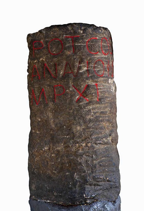
I love milestones. There is something so definite and so grounding about them, and the way in which they locate with reference to other places – you are X miles from Y – you know exactly where you are in the world. They have a long history – the Romans used them all the time, and in reality, they haven’t changed since. This one was found in Buxton, and is inscribed with the following: “TRIB POT COS II P P A NAVIONE M P XI”.
Buxton Roman Milestone, found in 1862 (and shamelessly stolen by me from the wonderful ‘Wonders of the Peak‘ website). Honestly, it is well worth taking the time to look around the site.
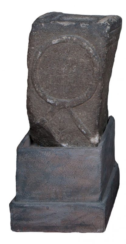
Which translates as “With tribunician power, twice consul, father of this country, from Navio, 11 miles”. The Roman fort of Navio is at Brough, near Castleton (information here). This is a great little fortlet, right on the river there, and well worth a trip out to see it. There’s not a great deal to see as such – rather like Melandra, it is lumps on the ground, requiring a bit of imagination – but it produced some fascinating archaeology. My favourite being an altar to the goddess Arnomecta – a local goddess, about whom we know nothing at all. She may be the same as the Goddess Arnemetiae who gave her name to Roman Buxton – Aquae Arnemetiae, but then again possibly not. Something about that both fascinates and frightens me – a lost Goddess.
Altar dedicated to Arnomecta – stolen again from the wonderful Wonders of the Peak website (use the link in the text above it for more information on the stone).
But I digress… where were we?
Milestones. Mine are nothing like as old, but they are interesting. Honest.
The first is located on the Woodhead Road/B6105 by Allmans Heath Farm and B&B. It is carved into the side of a mounting block, used for getting onto horses, is/was painted white, and it simply states ‘Glossop 1 mile’ with an arrow pointing the direction.
The milestone is at the bottom, carved into a niche. The ring on the block would have held your horse in place whilst you climbed aboard.Close up of the milestone: “Glossop 1 Mile”
Now, the mounting block is clearly old. They don’t make them anymore, for one, and the fact that the ring has been set in place using lead would certainly age it to the Victorian period, and potentially earlier. The carving is another matter altogether. I had assumed that the words would have been carved in the Victorian period, but on the way to take the photograph, I got speaking to the owner of the house there who informed me that they were only 10 years or so old – her ex-husband, being a stonemason, carved them. Well, why not? The fact that the mounting block sits next to a very old stone gatepost (on the right in the upper picture) suggests that the owners had moved the stone to the front wall in order to create a feature, which it does.
So, this one might not be of any great age, but the next two certainly are, even if they are slightly out of the area.
I went looking for the fabled White Stone of Roe Cross the other day.
I say fabled as there is very little information about it, and I was hoping to see it to put in my two penn’orth about what it is, why it is, and where it is. It is mentioned in Sharpe’s “Crosses of the Peak District” as potentially marking the junction of the boundaries of Matley, Hollingworth, and Mottram, so I thought it would be worth a look. Alas, I failed utterly to locate it, although I did get as near as White Stone Cottage, so I could’t be too far away. It has almost no presence online, either, besides a letter that was written to protest against the proposed Mottram bypass which mentions it in passing, and references to White Stone Cottage.
If anyone knows the location of the stone, please let me know, as I’d love to see it – and you all know how much I love a good stone.
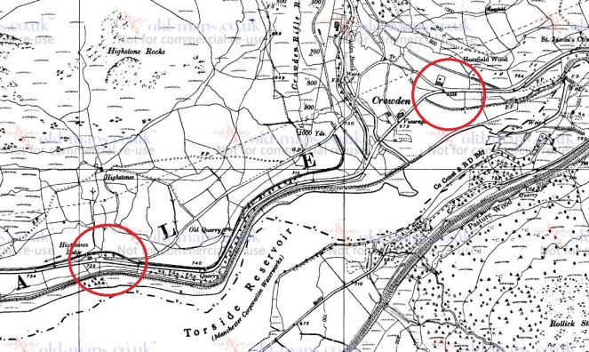
Now, that same letter, also mentions a carved milestone in that area, and thinking it might be worth a look, young Master Hamnett and I set off down Dewsnap Lane to find it. Which we did in record time – standing alone in a right hand turn into the riding stables there (the location is shown by the red circle on the map below).
The Lonely Milestone
The stone states it is “10 Miles From Manchester” and I have no reason to doubt that. It has clearly been used as a gatepost at some stage, and you can see the hole where the hinge was mounted.
Close up of the writing and hinge hole.
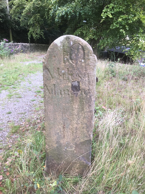
As I turned around to leave the stables area I noticed another milestone, this one placed against the wall.
Another milestone
This one proclaimed itself to be ’13 Miles From Manchester’.
“Hmmmmm”, thought I. “Ice cream” thought Master Hamnett.
Close up of the carving.
Now, I know what you are thinking… that Roe Cross is a geographical anomaly, being simultaneously both 10 and 13 miles from Manchester; a quantum place, if you will.
The two stones are obviously carved by the same hand and at the same time – the rounded top and squared shoulders are the same in both instances, and the stone is the same – a coarse sandstone. The writing is also the same, and with the ‘long S‘ in the word ‘Manchester’, we can roughly date it to not later than the first half of the 19th Century, and possibly a little before. After this time it falls out of use, and people used the ‘short S’.
So what are they doing there? I don’t know for certain, but I have a possible/probable answer.
The ‘Deep Cutting’ between Mottram and Matley/Roe Cross was opened in 1826 as part of the Manchester to Saltersford turnpike road. Essentially, it allowed easy access between Yorkshire and the east of the country, and Manchester and the west. Prior to this, the roads were in a terrible state of repair, and the heavily laden packhorses that made that journey really had to struggle. The turnpike roads were privately financed and built, and in order to recoup costs they operated as toll roads, charging for their use (think M6 Toll road for a modern comparison).
The toll gate at Roe Cross, the place you had to pay for passage, was situated here:
The Roe Cross Toll Gate is marked on the map (indicated by the arrow). The circle shows where the milestones are now situated. This from the 1875 1:2,500 OS map.
Now, obviously, the milestones are not in their original location, and I would like to suggest that they were originally situated near to, or at, the toll gate, showing the distance to Manchester along the road. However, if that was the case, then why the difference in distance? Well, perhaps the ’10 Mile’ sign was put next to the new road, whilst the ’13 Mile’ sign was by the original, old, road. With both signs showing, most people would want to shave 3 miles off their journey, and travel along a new well surfaced road, rather than along a muddy track, pitted with animal and cart ruts – after all look how many people use the M6 Toll Road. The tentative date of the stones, too, fits with the construction of the road – the first quarter of 19th Century.
Of course, once the toll gate ceased to exist, the stones lost their usefulness, and particularly once new, more clear, signs began to be used on the roads. However, instead of being broken up, their size and shape is perfect for a gatepost, and so they were hauled a few hundred yards up the hill and given a new function.
Well worth a look of you get chance, and there is lots of good walking to be had up there. I am going to have good explore myself sometime soon, particularly up Gallowsclough, which, as a placename, can have only one meaning – ‘the valley where they hanged people’. Blimey!
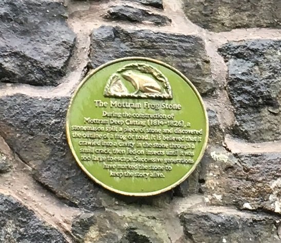
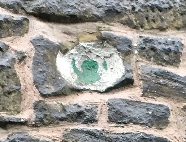
Incidentally, I love the Deep Cutting for the Mottram Frog Stone which is celebrated on the wall there, about half way down on the right (going from Mottram to Stalybridge). I couldn’t do this post and not mention it – I tweeted about it, but it is so good, that it needs to be celebrated on the blog, too.
The truth or plausibility of the story is much less important than the legend – no one criticises a fiction story for not being real, one just enjoys it!The stone itself, marked with a green frog.
There may be more this weekend, if I can manage it, but I will try to get back to my one a week post target, so stick around. Thanks for reading, and please, as always, comments and corrections are always welcome.