Archaeology · Folk Tales · Oddities

Gallowsclough

There’s no mistaking some etymologies.

Placenames in the past were given because of what was there, not aspirational or deliberately flowery. They were practical. Descriptive. Truthful. There was no Laurel View if there was no view of laurels. Gnat Hole was not named ironically. And Shittern Clough was… well, you get the picture.

For me, Gallowsclough has always stood out in the map of the area – the clough, or narrow valley, where the gallows were. There is something of the macabre about the name, and I was also aware of a folktale from the area which really made an impression on me (more of that in a bit). So I decided to do some exploring, to see if I could add to the placename, and see if I could work out where the gallows were… as Mrs Hamnett put it “lucky me, you take me to the loveliest places”.

I’ve blogged about this area before (White Stone of Roe Cross), but the area is effectively the Deep Cutting between Mottram and Stalybridge. Gallowsclough is highlighted (the clough itself, or small deep valley, running towards the Dog and Partridge).

Gallows 1b
Gallowsclough and area. This from the 1898 1:2500 OS map (via the awesome oldmaps.co.uk). The main road to Stalybridge from Mottram runs diagonally through the map, with the deep cutting starting at the Wagon and horses.

So then, the gallows.

The last person to be hanged in public was in 1868, after which time, and until capital punishment was abolished in 1965, executions took place within the prison, away from the public eye. But before 1868 it was a public spectacle, to the point that the hangings at Tyburn were turned into a public holiday. Often associated with the public hangings of the 17th and 18th centuries was the punishment of gibbeting, in which the hanged criminal was enclosed in a tight fitting cage or chains, and effectively left to rot. The body was  covered in tar in order to protect it against the elements, and hung there as a warning to others until it finally fell to pieces.

Each area, feudal estate, or manor had a gallows/gibbet, and certainly until the later Tudor period or even the early modern period, capital punishment was the responsibility of the lord or equivalent. It seems that the victims were buried underneath, or nearby, the gallows, but certainly not on consecrated ground. To be executed was to be condemned to eternal restlessness, to never know peace, and to wander the Earth an unhappy spirit.

In order to achieve maximum visual impact, the gallows were normally set up at prominent places – central open spaces, or more normally, crossroads. And so it was here, in Roe Cross. The body swinging, both at execution, and in a gibbet, could be seen  easily by both locals, and by travellers moving along the various roads – a physical reminder to obey the laws, or suffer the consequence. Interestingly, this tradition of both execution and burial at a crossroads has given rise to the concept that a crossroads is an odd, supernatural, place. If you want to sell your soul to the devil, where do you do it? Where do you bury witches? Or suicides? Or criminals? At the crossroads, that’s where.

So where were the gallows at Gallowsclough? It is very doubtful that they would have placed them further up the clough – difficult to get to, in arable land, and there are no crossroads. No, I think they erected the gallows at the point Gallowsclough – the clough, or deep valley, upon which the gallows are placed – crosses the road. At almost exactly the point seven – count them – seven tracks join. This is no crossroads… this is a crossroads and a half. Here is a map showing the tracks (numbered).

Gallows 1
The seven tracks shown on the map existed before both the turnpike road and the ‘Deep Cutting’ were made. Walking them, you can see why the turnpike was created. It is still perfectly possible to travel to and from places on these tracks, but perhaps don’t if you don’t have a 4×4.

This is the area close up – you can see the tracks meeting.

Gallows 1 - closeup
Right by the Wagon and Horses… enjoy your pint!
Crossroad Blues
This is the site. You can see the roads meeting, and here at the bottom of Gallowsclough Road, you can see the setts of the original track, laid to give horses some traction at the start of the hill.

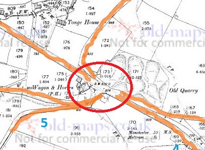
The roads are as follows (the numbers are faint in blue in the map above):

  1. Gallowsclough Road – From Saddleworth, via Millbrook (avoiding Stalybridge). This is the Roman Road between Castleshaw Roman fort and Melandra (thanks Paul B.)
  2. From… well, the middle of nowhere – local traffic from farms
  3. From Hollingworth.
  4. From Mottram via the old road.
  5. From Hattersley, via Harrop Edge.
  6. From Newton.
  7. From Stalybridge, via the old road.

A perfect situation for an execution and gibbet. It was said that it was to these gallows that Ralph de Ashton (1421 – 1486) sent the unfortunate tenant farmers who couldn’t pay the fines for allowing Corn Marigold to grow amongst their crops. The death of the hated Ralph is the origin of the Riding the Black Lad custom and the Black Knight Pageant in Ashton Under Lyne, a tradition sadly no longer undertaken. Naturally, the area is said to be haunted, with the locals avoiding the place, even in daytime. Although, as is so often the case, there are no references, only suggestions.
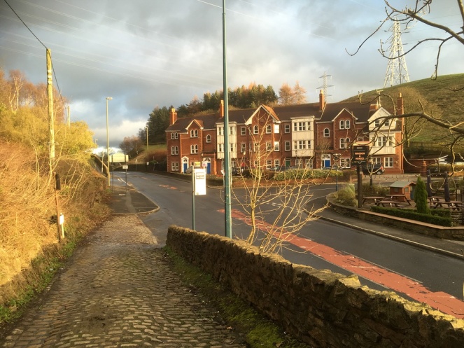
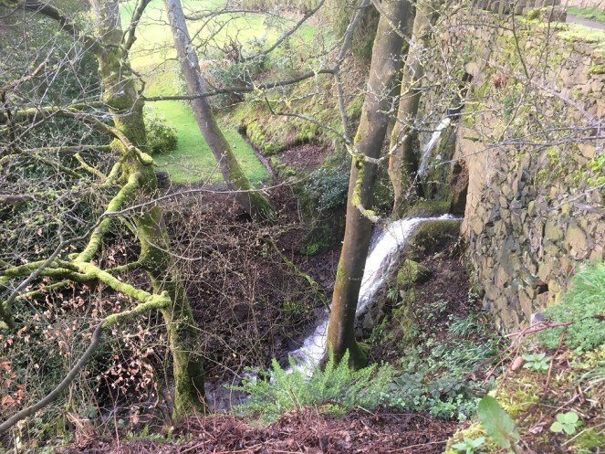
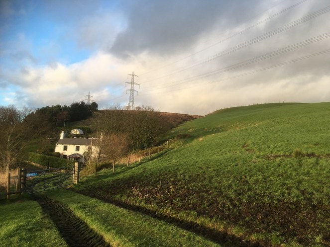
This is the clough

GH
The brook flows under Gallowsclough Farm.
hg
Gallowsclough in the background, behind Gallows Clough Farm. The electricity pylons completely ruin the area, unfortunately.

Of course, whilst I was stomping around, I happened upon a bunch of mole hills…

RC1

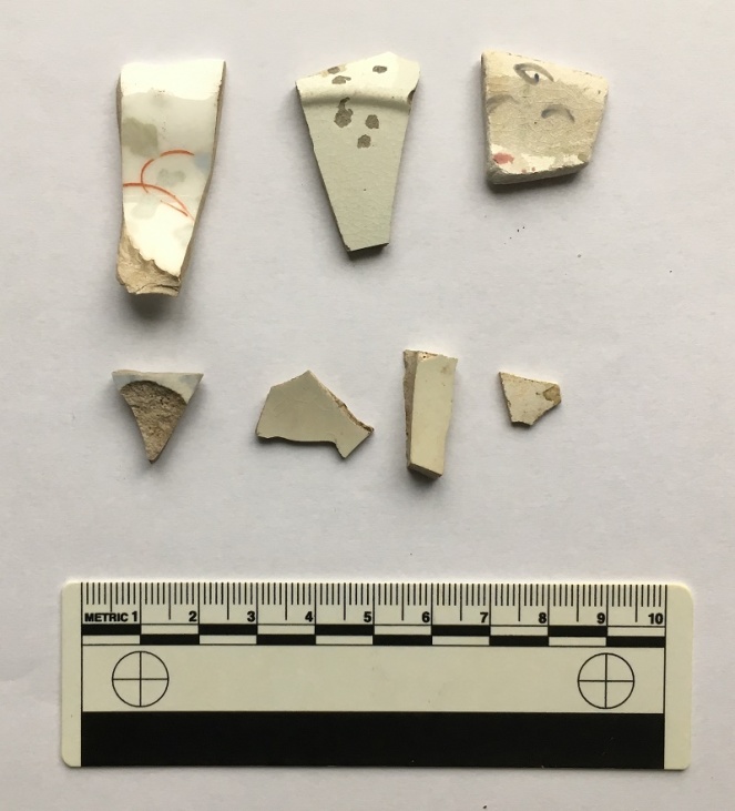
Evidence of nightsoiling (as I’m sure you all know, having read previous posts about this). The top row right: a medium bone china plate (c.18cm in diameter), hand painted flowers and abstract floral designs in pastel colours. This is quite nice, and is probably early Victorian in date. Middle is a plain white glazed plate, thin, and again about 18cm in base diameter (you can see the ring of the base in the photo), which makes it perhaps 24cm or more in ‘real’ diameter. Left is more difficult – it has an undulating rim, with a curled decorative motif – which means that I can’t tell you how big it is. Over 25cm in diameter, I suspect. It is a shallow dish, or deep plate, and is deocrated with abstract floral designs. Date wise? Late Victorian? Looks more modern than that, though… Edwardian? The bottom four are fairly boring body sherds, though the sherd on the left is a blurred willow pattern, so potentially quite early?

RC2
Contents of a Molehill, pt. II

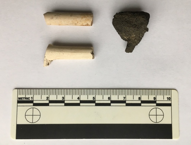
The ubiquitous lump of coal/coke to the right, and the ubiquitous clay pipe to the left. The lower of the pipes is nice as it still has the spur that juts out and forms the base of the bowl, which you can see just emerging. It’s probably early to mid-Victorian in date. -Check out this wonderful website for more information.

pipe
The spurred type of pipe is middle right.

And finally, to end on, this lovely thing.

RC3
Ding dong, the Mesolithic calling.

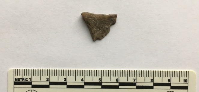
A flake of quartzite that has been struck in prehistory, during the course of making a tool. Flint doesn’t occur naturally in this area, so all sorts of stones were used in the making of stone tools in prehistory. Quartz, though a poor cousin of flint, still keeps enough of an edge to be useful, and this piece carries all of the hallmarks of a bit chipped off a larger tool or weapon – the striking platform (top), and the bulb of percussion (facing, half way down). I suspect that this is Mesolithic in date, so c.6000 – 4000 bc, or thereabouts. I’ll post some more flint/chert/quartzite when I get a chance, as it’s fascinating stuff, and the area is not exactly lacking in it.

*

Interestingly, there is a brewery marked on the map (top left, numbered 8). This is the Matley Spring Brewery, which brewed beer here, using the local spring for water, and presumably selling it in the Dog and Partridge, at the end of the wonderfuly named Blundering Lane. I was going to write a little about it, but came across this site with some information and photographs. Actually, the whole blog is a good read, filled with fascinating titbits relating to the area, so go forth and explore.

*

And finally, as promised, I’ll end with the folk story of Gallowsclough. This is taken from Thomas Middleton’s Legends of Longdendale (the book is a mine of local legends and folktales, as well as some good photographs, and is well worth seeking out – or reading in the pdf format at the link below)

Follow this link for The Legend of Gallow’s Clough.

It’s very Victorian in its telling, but the story is as black and evil as any I have read; there is something about it that disturbs and lingers in the mind – the imagery, and particularly the witch walking away at the end. No, I like a good dark folktale, but this is just on the border of being a little too dark for my tastes. Enjoy at night, and you have been warned…

So there you go. There’s plenty more in the pipeline, so watch this space. As always, comments are very welcome, and all will be published.

And I remain, your humble servant,

RH

Stones of Glossop

The White Stone of Roe Cross

So, a while back I went looking for the White Stone of Roe Cross… and failed miserably in my mission.

As I said here, it is mentioned in Sharpe’s book “Crosses of the Peak District” as potentially marking the junction of the boundaries of Matley, Hollingworth, and Mottram, so I thought it would be worth a look, and maybe make a comment on what, where, and why.

I did some digging (pun fully intended), and came up with very little; it has almost zero presence online (other than this letter), and other than a modern book (about more, later), virtually nothing but an oblique reference. I began to despair… until I started to dig a little further – my ‘spidey sense’ began to tingle. Summat wants fettling, thought I.

What I did come across time and again was a reference to the legend of Sir Ralph de Staley, and his relation to Roe Cross, and the Roe Cross. Now, the story of Sir Ralph de Staley (Staveley or Stavelegh or Staveleigh – there are numerous spellings), is a variant of “The Disguised Knight”, a story trope that can be traced back to at least Homer’s ‘Odyssey’. Our story, culled from several sources, runs like this.

With Richard I, Sir Ralph sets sail on a crusade leaving behind his wife, Elizabeth, and estate. By and by, and following many great battles, he is captured by the Saracens, and held for many years in a dungeon. Eventually, he gains his freedom, takes on the appearance of a Palmer (a pilgrim), and pays a visit to the pilgrimage sites in the Holy Land. One night, in Jerusalem, he had a prophetic dream “boding ill to his wife and home far away”, and so, invoking the intercession of the Virgin, he prayed and presently fell asleep.

Upon awakening, he immediately knew something was different – “before him, shining fair in the summer sunlight, rich in fulsome melody of singing birds, was a fair English landscape, and beyond it his own ancestral hall of Staley”. He had been miraculously transported home.

He set off for his house, and came upon a faithful old servant and his favourite dog, who presently recognised him. He told Sir Ralph that his wife, who had finally given up all hope and now believed him dead, was to be married the following day. So off he jogs to his hall, and asks to see the lady of the house. He is refused, but begs a drink of Methyglin (a type of spiced mead, apparently), and after draining the cup, pops his ring into it, and begs the maid to take it to her lady. She does, his wife recognises the ring as belonging to her husband, and asks an important question “if it be Sir Ralph himself, he will know of a certain mole on me, which is known to none but to him” (racy stuff, this). Of course, all ends well and happily, and the bounder that is trying to get Sir Ralph’s lands and his missus, is ejected rapidly into the night. And quite right, too.

So ends the story.

Staleyhall
The 15th Century timber-framed Staley Hall before being done up. That is truly one of the most depressing photographs I have ever seen. How we can let our history end up in this state…
Staleyhall2
That’s better, although the wall at the front is a little off putting. The restoration work here is particularly good.

Now, here’s where it gets interesting. As a post script, most versions of the story (there are about 5, each with subtly different aspects) state that a cross was erected either where Sir Ralph meets the servant and dog, or where he wakes up following his miraculous movement. This is the Roe Cross – Ro, or Roe, apparently, being a shortened version of Ralph. Indeed, several sources mention a cross standing on the old road from Stalybridge to Mottram. But where is the cross? There is certainly not one there now, nor is there any evidence attesting to one. There is, however, the White Stone.

Ok, so here is what I think happened.

I don’t think there ever was a cross, not as such. None of the sources I consulted actually describes a cross, only that one was there (as told by the story and indicated by the name), or that there are the “remains of an ancient cross” on the road there (and thus presumably referring to the White Stone). It seems that the White Stone and the Roe Cross have become intertwined. Ralph Bernard Robinson, in his book ‘Longdendale: Historical and Descriptive Sketches‘ (1863) illustrates this perfectly by noting the existence of both cross and stone as separate monuments, but he only describes the stone, not the cross. I would argue that it doesn’t/didn’t exist.

It is most likely the name Roe Cross is derived from ‘roads cross’; the area is, after all, the junction of seven roads – Harrop Edge Road, Matley Lane, Gallowsclough Road, Mottram Road (Old Road), Hobson Moor Road and Dewsnap Lane. Indeed, according to Dodgson’s Place Names of Cheshire (Vol.1, p.315), there seems to be no reference to Roe Cross prior to 1785 (although this may turn out to be incorrect, with further research).

Roads Cross
Roads Cross = Roe Cross. You can see the coming together of all seven ancient tracks, converging on Roe Cross. Ignore the 18th Century Turnpike at the bottom.

So far, so good… now bear with me. The White Stone is a marker stone, marking tracks over the tops, and/or marking the boundaries of Matley, Stalybridge, and Hollingworth, and it has been there from the year dot. As a feature in the landscape, it was given a story, as all such features are – they accumulate stories, because people have an intrinsic need to have a relationship with their environment – and it takes on a personality, and gains a biography. As the archaeologist Richard Bradley says of monuments “they dominate the landscape of later generations so completely, that they impose themselves on their consciousness”. The story of Sir Ralph (whether ‘true’ or not) was given as a way of explaining both name – Roe Cross – and reason for the existence of the marker stone. In fact, in Ralph Bernard Robinson’s account of the legend, Sir Ralph wakes up “beside a large stone”, and later on notes that “tradition points out the stone under which he found himself laid: and a queer old stone it is.” Clearly he is describing this from his own personal experience, and surely there can be only one stone that is worth pointing out in the Roe Cross area… it has to be The White Stone.

As a postscript to the postscript, Sir Ralph and his wife, Lady Elizabeth Stayley, are supposedly buried in St Michael and All Angel’s church, Mottram. There are two 15th Century carved effigies that are to be found in the Stayley Chapel there, which almost certainly are meant to represent the good knight and his wife, and which were originally placed against the south wall of the chapel. As Aikin in his ‘Description of the Country Thirty to Forty Miles Round Manchester’ (1795) notes, “many fabulous stories concerning them are handed down by tradition among the inhabitants”.

Staly
This from Aikin’s Description of the Country Thirty to Forty Miles Round Manchester’
Staly 2
Sir Ralph and Lady Elizabeth de Staley. This taken from the official guide to Mottram Church here.

So then, the White Stone. Well, I still haven’t found it! But I do know a bit more about it, and now – drum roll please – I have a photograph of the bloody thing, stolen shamelessly from Keith Warrender’s book ‘Manchester Oddities‘. I heartily recommend this book, as it’s chock full of just the sort of odd bits of history that this blog looks at. Buy it here. Or better yet, order and buy it from Bay Tree Books – buy local and keep independent shops afloat.

So here is the offending stone, in whose shade, Sir Ralph found himself transported from the holy land.

White Stone a
The White Stone of Roe Cross – it is indeed a “queer old stone”.

The reason for it being white is presumably to make it stand out, to ensure this important stone (boundary marker, track marker, or teleportation stone) is kept vividly different from any other in the area. Apparently it’s now on private property, which would explain why I couldn’t find it last time I went looking for it. I’m not sure of its exact location, but somewhere in the vicinity of White Stone Cottage would seem to make sense. Here is the drawing in Sharpe’s ‘Crosses of the Peak District‘.

White Stone b
Not very cross base shaped, but then I haven’t seen it close up. Yet.

I love it when a legend has a physical mark in the landscape, it makes it more real, and as I say, it is a natural instinct in humans to build stories around their places. I recently led a guided archaeological tour of Alderley Edge, which looked at the Legend of the Wizard through an archaeological lens, and this same element, on a smaller scale, was at play here. Place and story working together, informing and shaping each other.

Apologies for the slightly rambling nature of this blog post, but I hope you enjoyed it.

As always, comments and questions are most welcome.

Your humble servant,

RH

Stones of Glossop

Multiple Milestones

Well, three to be precise.

What ho, what ho, what ho! So, I’m back from my summer holiday. Actually, I was only in France for two weeks (with lots of cheese and wine), and the rest of the time I have been busy with life… alas. I have loved the weather here for the last 10 weeks – a decent summer at long last, and the polar opposite of the spring we had. Bizarre.

So, missing out August completely, I’m back with a bang, and hopefully more than one post over the weekend, here we go.

I love milestones. There is something so definite and so grounding about them, and the way in which they locate with reference to other places – you are X miles from Y – you know exactly where you are in the world. They have a long history – the Romans used them all the time, and in reality, they haven’t changed since. This one was found in Buxton, and is inscribed with the following: “TRIB POT COS II P P A NAVIONE M P XI”.

Roman Milestone
Buxton Roman Milestone, found in 1862 (and shamelessly stolen by me from the wonderful  ‘Wonders of the Peak‘ website). Honestly, it is well worth taking the time to look around the site.

Which translates as “With tribunician power, twice consul, father of this country, from Navio, 11 miles”. The Roman fort of Navio is at Brough, near Castleton (information here). This is a great little fortlet, right on the river there, and well worth a trip out to see it. There’s not a great deal to see as such – rather like Melandra, it is lumps on the ground, requiring a bit of imagination – but it produced some fascinating archaeology. My favourite being an altar to the goddess Arnomecta – a local goddess, about whom we know nothing at all. She may be the same as the Goddess Arnemetiae who gave her name to Roman Buxton – Aquae Arnemetiae, but then again possibly not. Something about that both fascinates and frightens me – a lost Goddess.

DERSB-1979-1301-415x800
Altar dedicated to Arnomecta – stolen again from the wonderful Wonders of the Peak website (use the link in the text above it for more information on the stone).

But I digress… where were we?

Milestones. Mine are nothing like as old, but they are interesting. Honest.

The first is located on the Woodhead Road/B6105 by Allmans Heath Farm and B&B. It is carved into the side of a mounting block, used for getting onto horses, is/was painted white, and it simply states ‘Glossop 1 mile’ with an arrow pointing the direction.

MB1
The milestone is at the bottom, carved into a niche. The ring on the block would have held your horse in place whilst you climbed aboard.
MB2
Close up of the milestone: “Glossop 1 Mile”

Now, the mounting block is clearly old. They don’t make them anymore, for one, and the fact that the ring has been set in place using lead would certainly age it to the Victorian period, and potentially earlier. The carving is another matter altogether. I had assumed that the words would have been carved in the Victorian period, but on the way to take the photograph, I got speaking to the owner of the house there who informed me that they were only 10 years or so old – her ex-husband, being a stonemason, carved them. Well, why not? The fact that the mounting block sits next to a very old stone gatepost (on the right in the upper picture) suggests that the owners had moved the stone to the front wall in order to create a feature, which it does.

So, this one might not be of any great age, but the next two certainly are, even if they are slightly out of the area.

I went looking for the fabled White Stone of Roe Cross the other day.

I say fabled as there is very little information about it, and I was hoping to see it to put in my two penn’orth about what it is, why it is, and where it is. It is mentioned in Sharpe’s “Crosses of the Peak District” as potentially marking the junction of the boundaries of Matley, Hollingworth, and Mottram, so I thought it would be worth a look. Alas, I failed utterly to locate it, although I did get as near as White Stone Cottage, so I could’t be too far away. It has almost no presence online, either, besides a letter that was written to protest against the proposed Mottram bypass which mentions it in passing, and references to White Stone Cottage.

If anyone knows the location of the stone, please let me know, as I’d love to see it – and you all know how much I love a good stone.

Now, that same letter, also mentions a carved milestone in that area, and thinking it might be worth a look, young Master Hamnett and I set off down Dewsnap Lane to find it. Which we did in record time – standing alone in a right hand turn into the riding stables there (the location is shown by the red circle on the map below).

IMG-0810
The Lonely Milestone

The stone states it is “10 Miles From Manchester” and I have no reason to doubt that. It has clearly been used as a gatepost at some stage, and you can see the hole where the hinge was mounted.

IMG-0811
Close up of the writing and hinge hole. 

As I turned around to leave the stables area I noticed another milestone, this one placed against the wall.

IMG-0808
Another milestone

This one proclaimed itself to be ’13 Miles From Manchester’.

“Hmmmmm”, thought I. “Ice cream” thought Master Hamnett.

IMG-0809
Close up of the carving.

Now, I know what you are thinking… that Roe Cross is a geographical anomaly, being simultaneously both 10 and 13 miles from Manchester; a quantum place, if you will.

The two stones are obviously carved by the same hand and at the same time – the rounded top and squared shoulders are the same in both instances, and the stone is the same – a coarse sandstone. The writing is also the same, and with the ‘long S‘ in the word ‘Manchester’, we can roughly date it to not later than the first half of the 19th Century, and possibly a little before. After this time it falls out of use, and people used the ‘short S’.

So what are they doing there? I don’t know for certain, but I have a possible/probable answer.

The ‘Deep Cutting’ between Mottram and Matley/Roe Cross was opened in 1826 as part of the Manchester to Saltersford turnpike road. Essentially, it allowed easy access between Yorkshire and the east of the country, and Manchester and the west. Prior to this, the roads were in a terrible state of repair, and the heavily laden packhorses that made that journey really had to struggle. The turnpike roads were privately financed and built, and in order to recoup costs they operated as toll roads, charging for their use (think M6 Toll road for a modern comparison).

The toll gate at Roe Cross, the place you had to pay for passage, was situated here:

Map - Roe Cross
The Roe Cross Toll Gate is marked on the map (indicated by the arrow). The circle shows where the milestones are now situated. This from the 1875 1:2,500 OS map.

Now, obviously, the milestones are not in their original location, and I would like to suggest that they were originally situated near to, or at, the toll gate, showing the distance to Manchester along the road. However, if that was the case, then why the difference in distance? Well, perhaps the ’10 Mile’ sign was put next to the new road, whilst the ’13 Mile’ sign was by the original, old, road. With both signs showing, most people would want to shave 3 miles off their journey, and travel along a new well surfaced road, rather than along a muddy track, pitted with animal and cart ruts – after all look how many people use the M6 Toll Road. The tentative date of the stones, too, fits with the construction of the road – the first quarter of 19th Century.

Of course, once the toll gate ceased to exist, the stones lost their usefulness, and particularly once new, more clear, signs began to be used on the roads. However, instead of being broken up, their size and shape is perfect for a gatepost, and so they were hauled a few hundred yards up the hill and given a new function.

Well worth a look of you get chance, and there is lots of good walking to be had up there. I am going to have good explore myself sometime soon, particularly up Gallowsclough, which, as a placename, can have only one meaning – ‘the valley where they hanged people’. Blimey!

Incidentally, I love the Deep Cutting for the Mottram Frog Stone which is celebrated on the wall there, about half way down on the right (going from Mottram to Stalybridge). I couldn’t do this post and not mention it – I tweeted about it, but it is so good, that it needs to be celebrated on the blog, too.

The truth or plausibility of the story is much less important than the legend – no one criticises a fiction story for not being real, one just enjoys it!
The stone itself, marked with a green frog. 

There may be more this weekend, if I can manage it, but I will try to get back to my one a week post target, so stick around. Thanks for reading, and please, as always, comments and corrections are always welcome.

RH