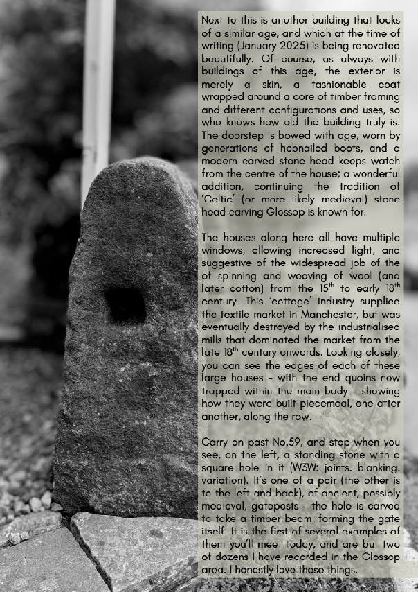
No, fear not, dear and gentle reader, I have not had some sort of ‘attack’, or a fit of the vapours, or conniptions, or a melancholic fever, nor indeed some form of ‘brain disorder’ resulting in a sharp dose of the ‘lah-lah-lahs’ (despite what some of you may think). I am tickety-boo; hunky dory; cock-a-hoop; and all is, in fact, distinctly oojah-cum-spiff… I am perfectly normal. Honestly, and all shall be revealed, so stick around.
What ho, wonderful folk, what ho! Spring is upon us: I have seen sweet blessed blossom on trees, and daffodils. Oh, daffodils! Now, if it can just stop raining for a minute or two, I might actually dance. But enough of this frivolity, let us look at some bench marks! Stop that moaning, you at the back… it’s unbecoming of a gentleman.
If you have spent any time on this website you will know that have covered Ordnance Survey bench marks before. Several times, in fact. And will also know that I love them with a passion. What on earth do you mean “obsessed” – I have an interest, that’s all. I can handle it. It’s not like I approach strangers and tell them all about benchmarks. Often. Well, not since the rather nasty court case and the restraining orders. Anyway, let’s move on. Swiftly.
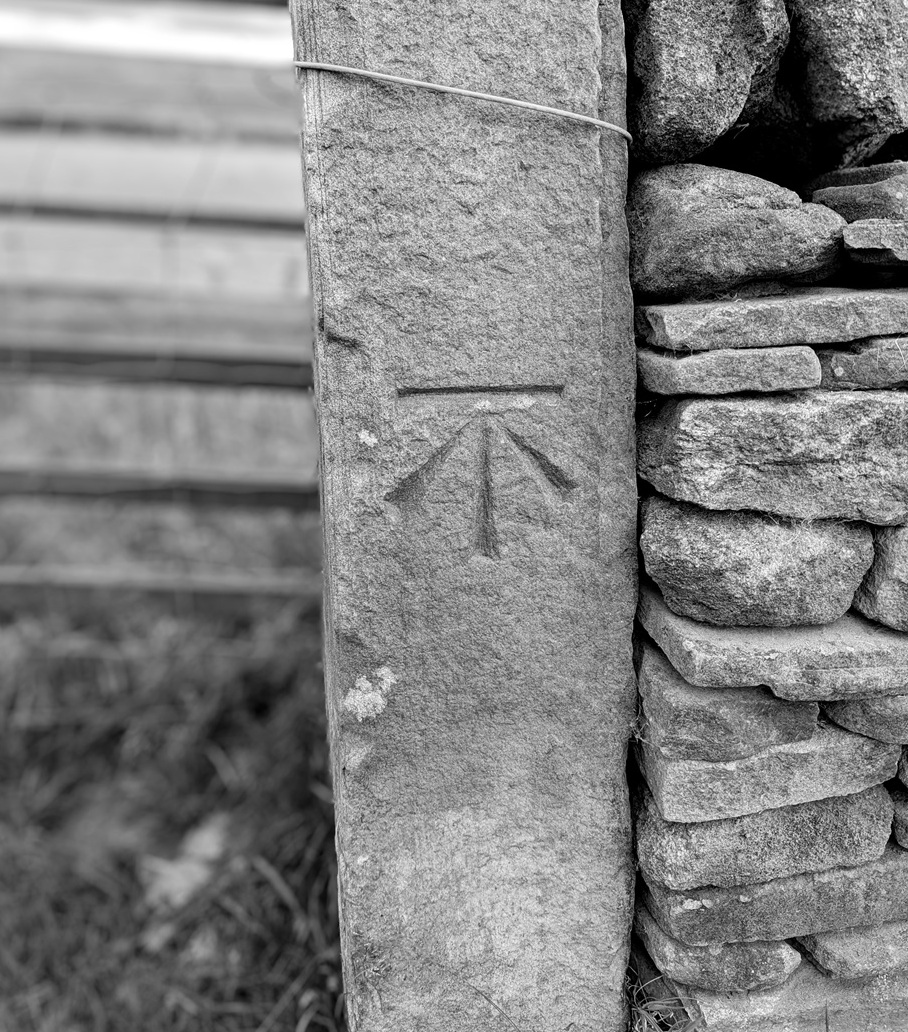
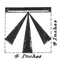
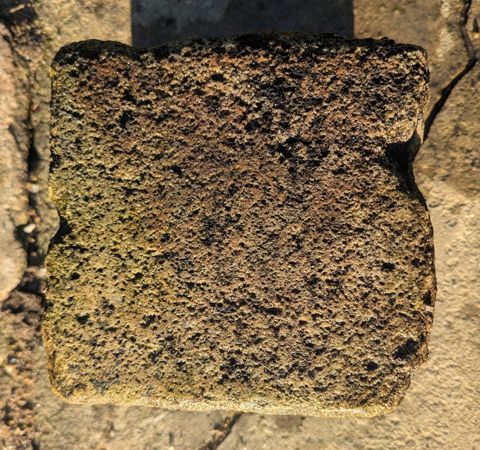
For those of you who don’t know (but dash it all, you should know), an Ordnance Survey benchmark is a mark carved onto a building or other immovable object that marks out a specific height above sea level. They are most often found as an arrow with a line above it:
The ‘broad arrow’ denoting British military ownership – Royal Ordnance – with a line on top.And here is one in real life – this one being precisely 682ft above sea level.
They are the remains of the original, and subsequent, surveys made by the Ordnance Survey in the 1840, allowing engineers and surveyors to record the whole country by height and distance. A remarkable feat, when you think about it: with each mark being intervisible with another, they are a literal network of heights, which, whilst visible in plain sight, is nonetheless overlooked or simply not known about by 99% of the population. I first encountered them whilst working as an archaeologist in the Oxford area where we used them to provide a height for the sites we were working on – essentially using an old fashioned level and ranging rod, we leapfrogged from the benchmark on a church to our site about a mile away, as this was the nearest benchmark, and we were working in the middle of nowhere! Benchmarks are marked on older OS maps, and they are found in their hundreds of thousands all over the country.
The system is no longer maintained, sadly, and they are falling into disrepair, but are much loved by nerds such as myself, who become, against their better judgement – and ignoring vague threats of divorce – Benchmark Baggers.
Now, occasionally, mistakes happen. The Ordnance Survey is very – painfully – good at what it does, but the people it serves – us – are not. Benchmarks go missing, or are moved, and sometimes too they are marked on buildings, but seem to have not been marked on maps. That is what this post is about – the anomalies and the oddities, not so much a benchmark… more a menchbark.
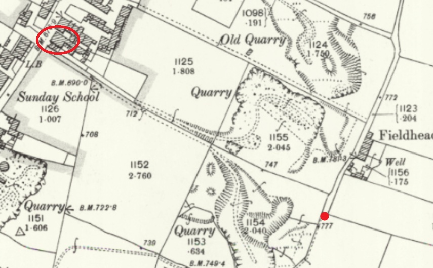
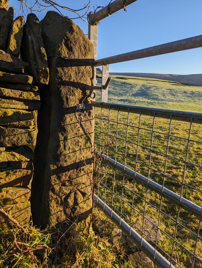
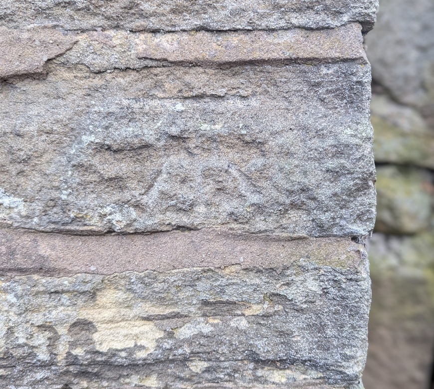
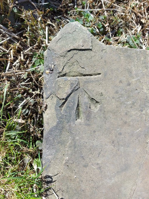
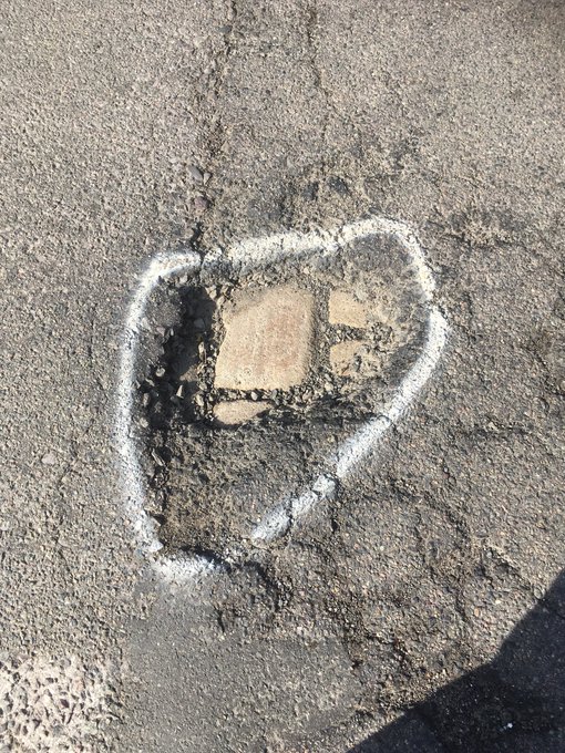
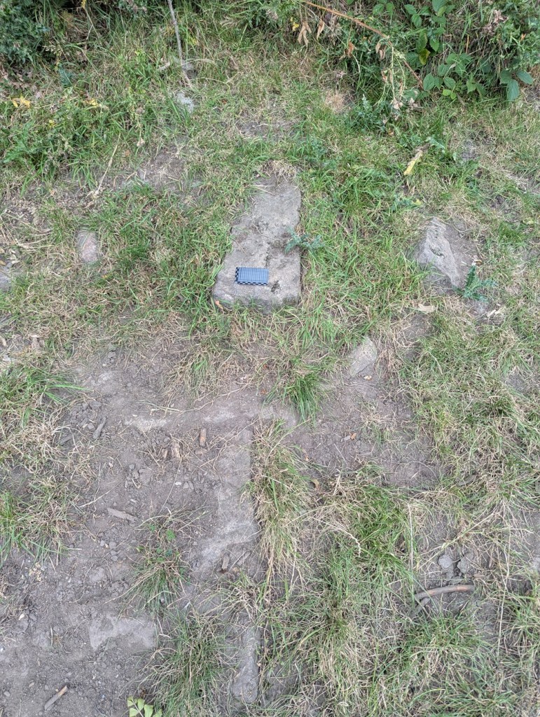
We start with Fieldhead Farm, Whitfield. The farm building itself has a benchmark, but nearby is a gatepost with a clearly carved benchmark on it; proudly stating the height above sea level of… we don’t know! It’s here on the map:
The Beehive pub is circled in red, for reference, but the benchmark is marked by the red dot.
There’s the mark, but the OS have never marked it on any map I’ve ever seen. And I don’t believe it has been moved from anywhere, either – that’s a solid piece of gatepost! Interestingly, it does replace a smaller square-holed medieval/post-medieval post. This is a very curious part of Whitfield that has a greater history than we currently understand – even the name ‘Fieldhead’ may suggest medieval origins.
Nearby, on Derbyshire Level is this lovely example:
This one was originally in the wall of the garden of Lane Ends Farm, Derbyshire Level. It still is in the wall, but the wall has been rebuilt fairly recently, and whilst it originally marked a height of exactly 705ft above sea level, and has been replaced in roughly the same place (amazing work, whoever did that), Jove alone knows what it marks now!
However, at least the people who rebuilt the wall understood that the benchmark had a purpose… and a right way up. Whoever rebuilt this wall in Hadfield – under the disused railway just by the start of the Longdendale Trail – had no idea what to do with it, so the benchmark was replaced upside down:
I mean to say… given that benchmarks for me represent an unmoving, permanent and fixed, point in a chaotic world (and mind), the sight of this inverted mark is literally turning my world upside down… and quite frankly gives me the heebie-jeebies.
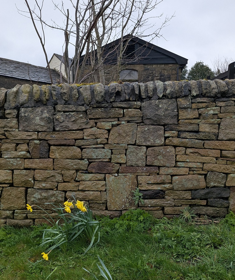
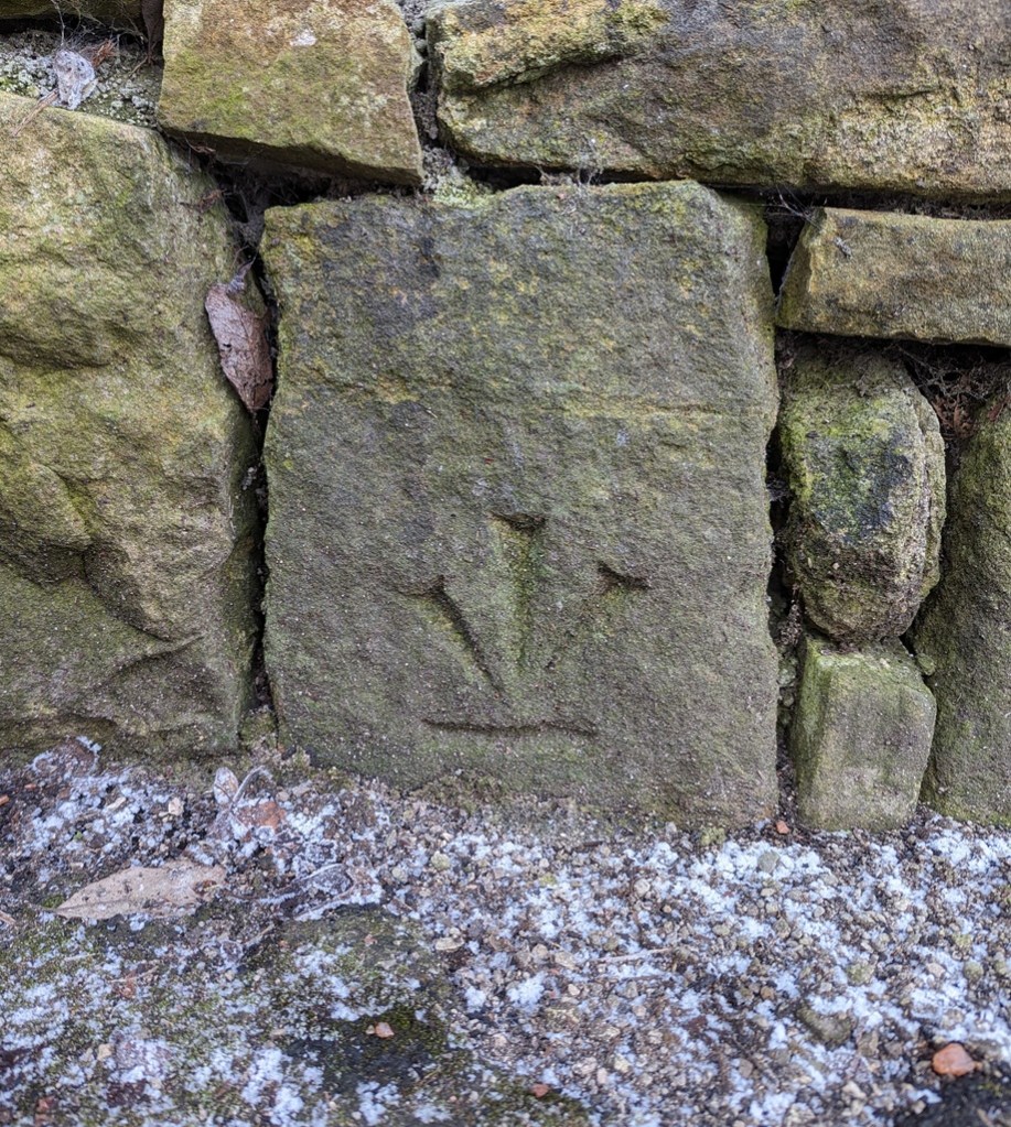
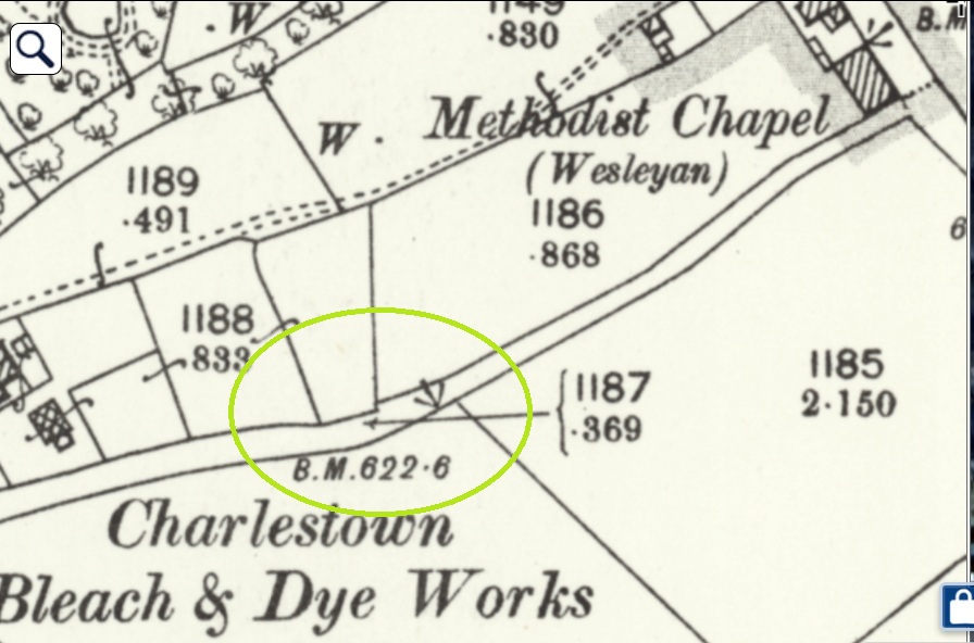
Here, on the southernmost of a pair of paths between Hague Street and Charlestown Road (and discussed in this article), we see that sometimes the mark is moved, probably due to some form of destruction or movement. So in 1898, the mark is on an object to the south of the path (a gatepost that is no longer visible, perhaps):
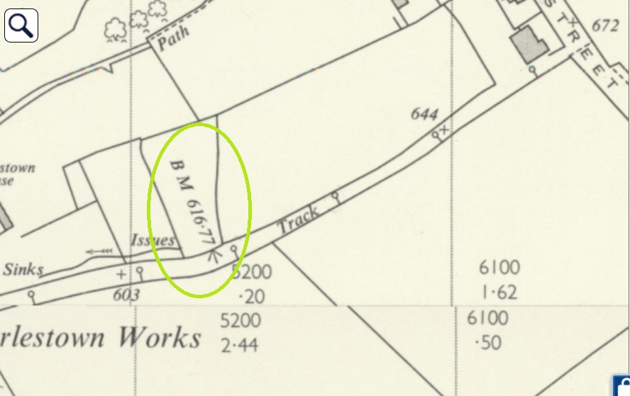
At some stage, the mark is rendered useless, and by 1968 it’s moved to the north side, and carved onto a gatepost, itself no longer used:
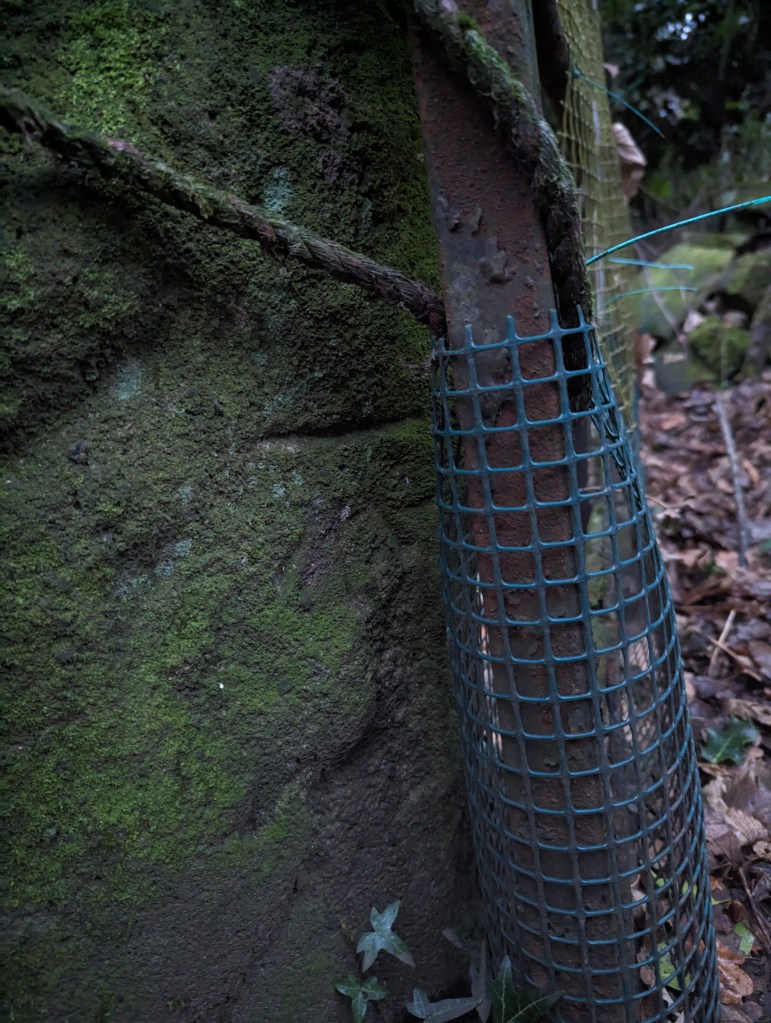
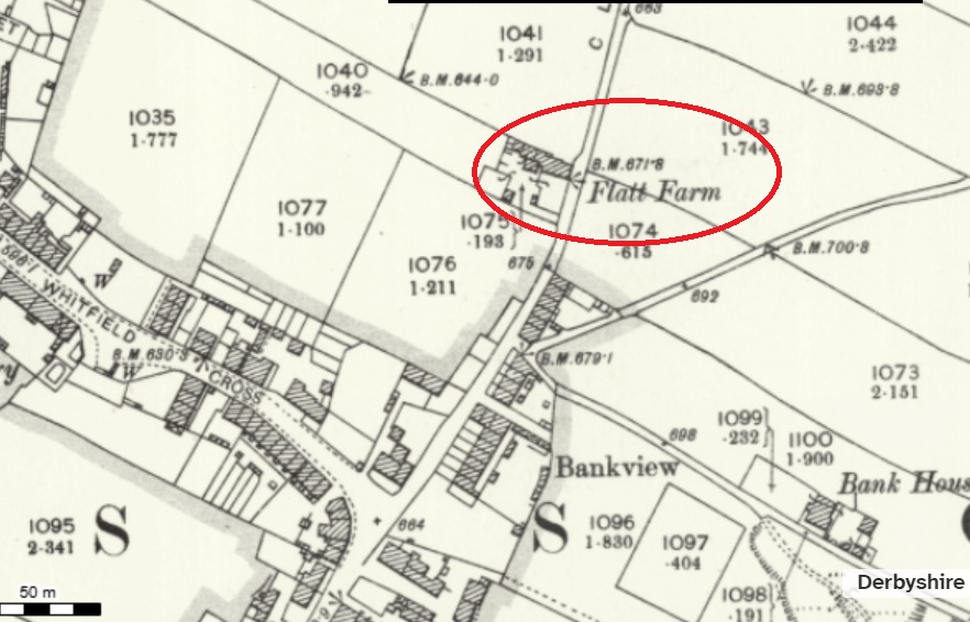
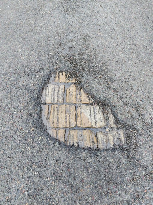
Next up, we have Flatt Farm, on Cliffe Road, Whitfield. The original benchmark is here:
1898 OS map
To the left of the building’s gable end. It is ridiculously low to the ground, with only the flat top showing – the result of the ground level having risen about 1ft.
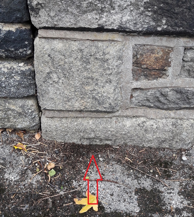
As a result, a later benchmark was cut into the right-hand side of the gable end:
A lot has changed by 1969… including the benchmark locationWorn and faded, it is there in the centre of the photograph.
The ‘new’ carving was poor by comparison, and has faded quickly, a symptom, perhaps; by 1969, the whole system was falling into disuse, and benchmarks no longer were marked on OS maps as a general rule. Sad, but there you go. Of course, now we don’t use them at all due to GPS, etc. But I honestly think there is something grounding and wonderful about them.
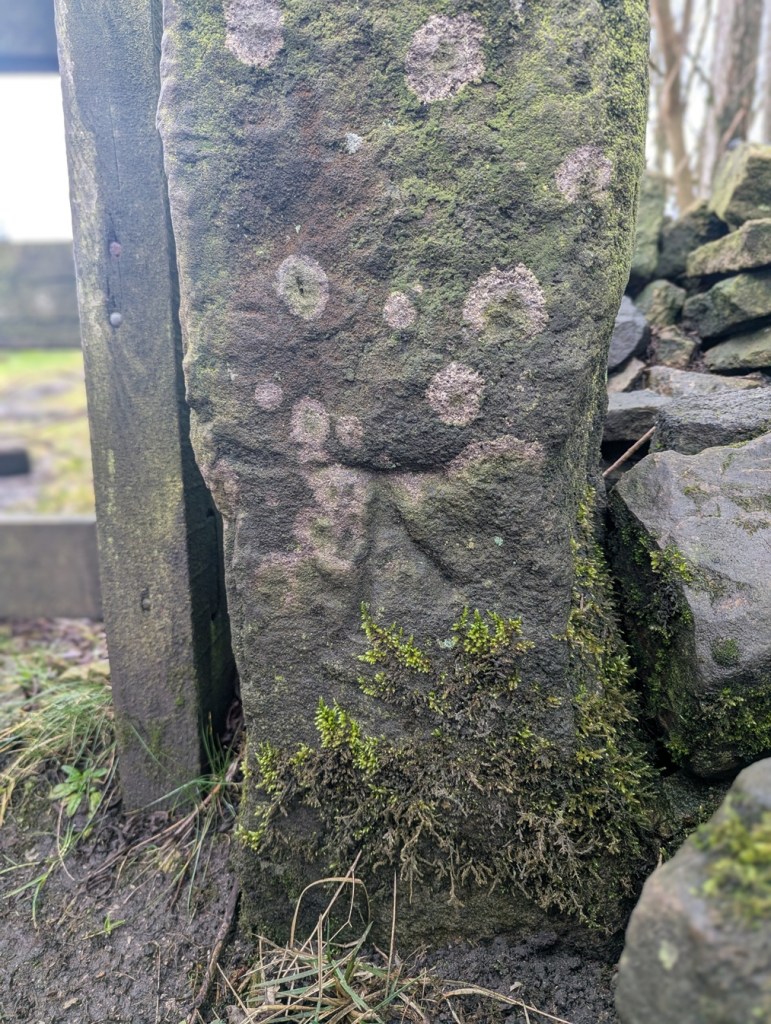
Anyway, whilst researching the latest Where/When (No.9), I discovered this wonderful specimen: potentially an abandoned attempt at a benchmark:
It’s at the right height – 1ft off the ground – and on the right sort of immovable object – a gatepost -and it would be in a perfect place for one, but it seems that during the carving process, a mistake was made – the stone may have crumbled, or a careless stroke was made, and the whole was abandoned. I might be wrong, of course, but that is what it looks like to me. You can have a look yourselves, here:
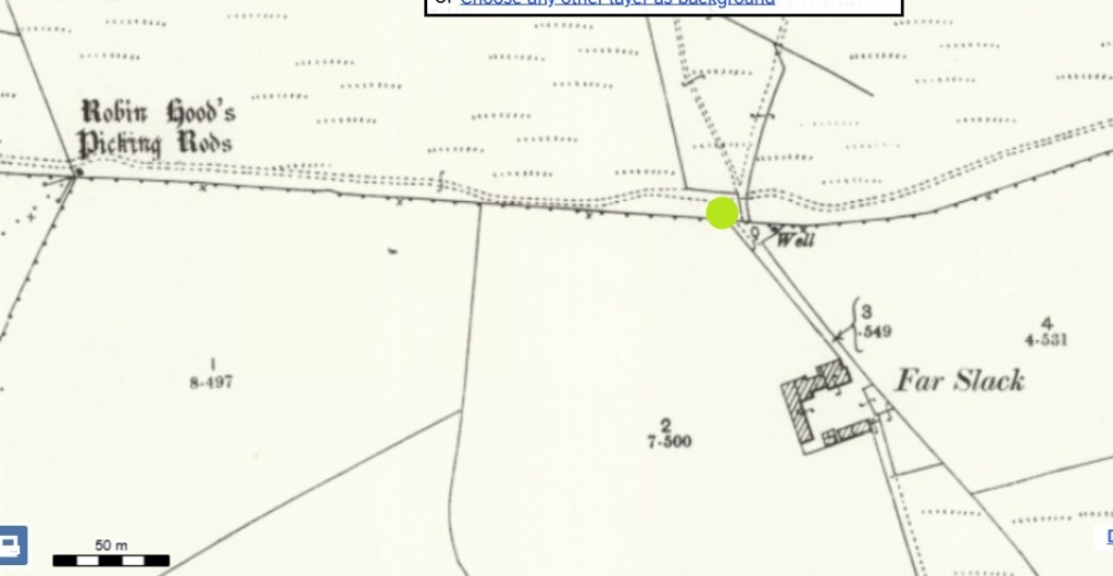
Facing the track to Far Slack farm, it’s the left hand gatepost (alos, right next to a rather spiffing holed gatepost, now lying on it’s side). The mark is also right by Robin Hood’s Picking Rods – a pair of 10th Century Anglo-Saxon Stone Cross shafts, and coincidentally, the stars of the latest Where/When – see below. Definitely worth checking out.
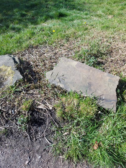
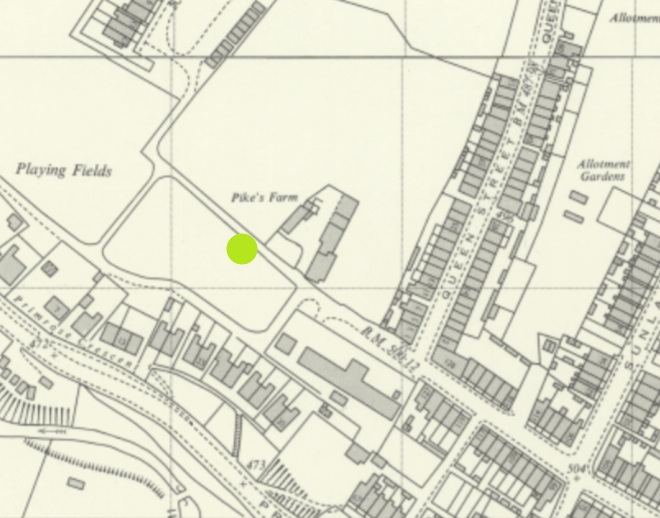
We’ll end on that most rare thing… a feral benchmark. Escaped from who knows where, it lurks, in a recumbent posture, and mocking all attempts at identification, just by Pikes Farm at the end of Pikes Lane. It’s been dumped from somewhere… but Jove knows where!
It was once on an upright gatepost, but is made from a non-local stone, so may have been brought from a distance. I contacted the OS, and they have no knowledge. A welcome visitor in our town, found here:
Left hand side of the track, just after Pikes Farm.
So there we go… interesting stuff. Well I like it, and I hope some of you like it too. Not you, Mr Shouty-Outy, we know, not you.
If you’re interested in benchmark bagging, I have recently begun using a phone app called TrigFindAR to help me find them. It has an almost complete map and database of benchmarks across the whole country, and allows you to tick them off as you find them (make them go from red to green) and to get onto the database kept at bench-marks.org.uk and look at that particular benchmark. I’m not sponsored – sadly – but it is truly a superb bit of kit, and is totally free; I cannot recommend it enough for you geeky types out there.
Elsewhere, the new edition of Where/When is out!
It’s an exploration of Cown Edge, Coombes Edge, medieval, prehistoric, and Roman archaeology, and a journey from The Beehive (Whitfield) to The Hare and Hounds (Simmondley). Essentially a guided walk around some really cool old stuff that starts and ends at a pub… what’s not to love. Think of it as a paper form of this website, but involving footpaths and loads to explore.
Available for £6.50 from the Where/When link above, or through the amazing Dark Peak Books and Gifts on High Street West, Glossop. Or just stop me and buy one!
Right, I’m off. I’m tired, grumpy, and am due a glass of the stuff that cheers any moment now. More soon, I promise, but until then, look after yourselves and each other. Please. We are all important, even if we don’t feel it sometimes. And until the next time, I remain.
What ho, one and all! We are still in the bleak midwinter, but I trust you are all bearing up under the strain. I am actively shivering as I write this, and I might have to light the fire… and have a glass of the stuff that both cheers, and warms.
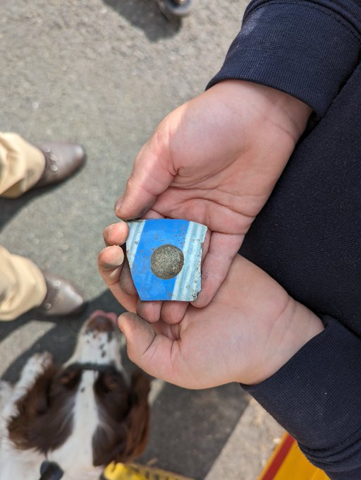
So then, this unexpected article presented itself through the extremely unlikely medium of a 9-year-old schoolboy! Actually, and to be fair to him, if you knew this particular 9-year-old, you wouldn’t find it that unlikely; he is one of those wonderful creatures that infests a school, creating mischief and chaos, and which forces you to tell him off. And yet he makes the day – and the job – so much more enjoyable, precisely because of the mischief and chaos, and because he is a thoroughly likeable chap. Stand up and take a bow Stanley, you marvellous man, you!*
At 8.55am, he bounces down the corridor towards me with a wide grin. “Good morning S, old bean” I hail. “Morning Dr CG” he replies “I’ve got something in my bag for you“. As opening gambits go, it’s a good one… I’m intrigued. “Shall I get it?“. “Ooooh, nice…” I say (slightly worried though, I know his mother… and the whole family, and frankly it could be anything in his bag). “No, wait until break time“. Break time arrives, and clutching a handful of something, he sought me out. Carefully wrapped in tissue is the subject of today’s article, and wonderful it is, too. Apparently, he found it on a Victorian (and later) rubbish dump, with his parents, and in a whole condition (remarkable in itself). However, the night before he had knocked it off a shelf in his room, and it now lay in three perfect pieces in the kitchen paper in front of me. Knowing that I’m archaeological, and somewhat pottery obsessed, he wondered if I might have some magic to work to fix it. And indeed I did (UHU yellow glue, and a cocktail stick, since you ask… remind me to show you sometime).
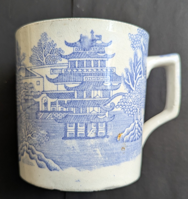
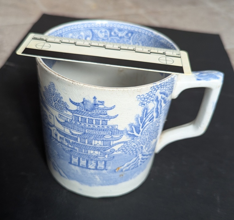
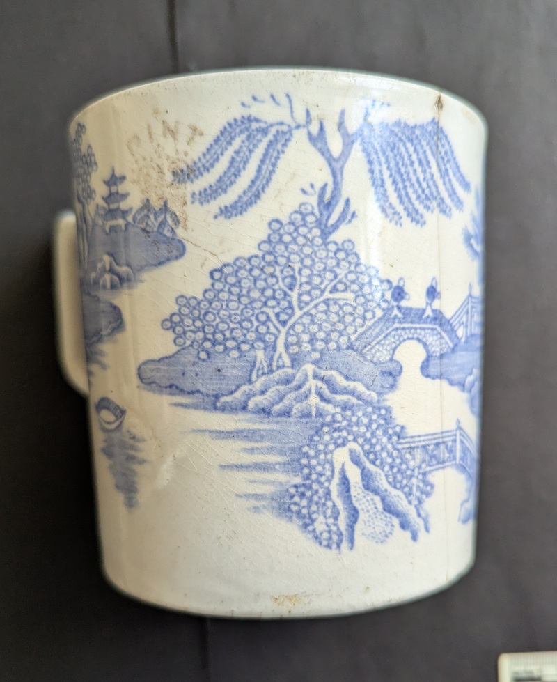
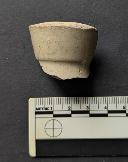
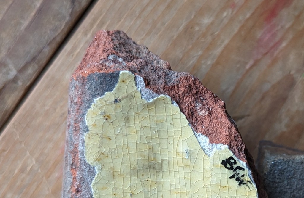
So then, it’s a mug. Blue and White transfer printed, and not particularly high quality. Victorian, I guessed. Biggish, but not huge, and not very refined in shape or small in size – 9cm in diameter – so didn’t immediately strike me as a tea cup… just a mug. Here it is:
A lovely thing! Not fancy, by any means, but lovely.
However, as I was inspecting the results of my mending, I noticed a few things that make this mug special, and immediately alarm bells began ringing – “I say! Here is a great article for the old website!” I thought, and, well… here is the very article.
Here is the mug from a variety of jaunty angles, to give a better idea of the decoration:
So then, a fairly standard blue and white transfer printed vessel (follow the link for more about Blue and White, and how it was made). Poor quality, I’m not going to lie – the blur at the top of the 4th photo above is not the result of my terrible camera work! It’s a smudge and a mistake on the part of the person applying the transfer. I mean no judgement by that – it was probably their (likely her, as it was largely a female job) 1000th transfer application that day, and with just another 1000 to go before a break. Incidentally, the brown spots on the exterior are the result of the mug lying next to something iron in the dump, and as the iron oxidises and rusts, it discolours the surface.
The actual standard of the transfer is poor too – I’m by no means an expert in this stuff, but it’s not a top notch engraving. It’s also not a standard willow pattern – it is ‘Chinese’ inspired, but not the tale of the two lovers changed into birds, etc. Instead, it is a pile of pagodas, Asiatic trees… and weird fish people, walking on their tails, and attempting to do the conga over a bridge. Which is… different.
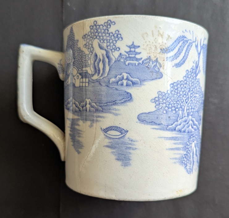
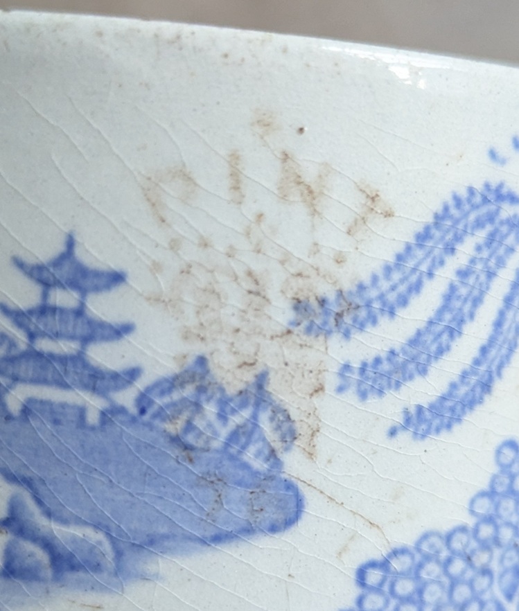
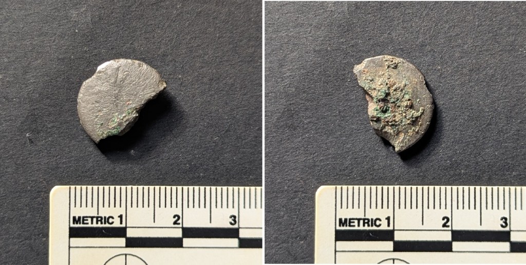
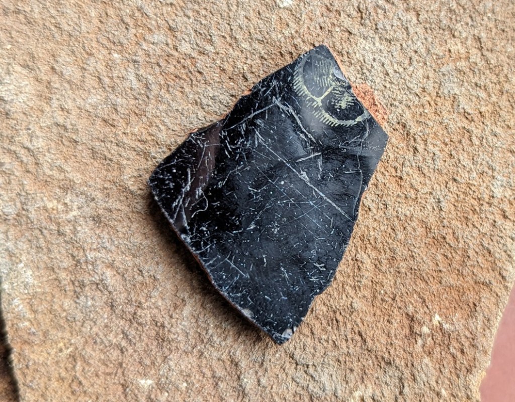
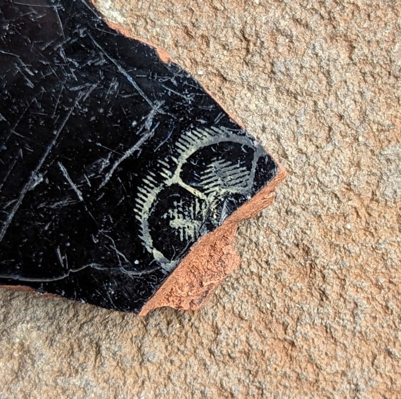
But it was this I noticed on the exterior that set me running to the website:
Etched into the glaze using acid.
It’s the word “Pint” over a crown, with the letters “G R” below, and over the number “76”. Now where have I seen something like this before? Oh yes… on every pint of beer I drank in a pub until 2006. It is the official Weights and Measurements Crown Stamp Mark, placed on every glass and mug used in pubs to ensure we are not sold a short measure. Originating in the Victorian period, after 2006 they were replaced by a CE mark, ensuring conformity to the EU standards, which in turn was replaced by a UK standard in 2021 following Brexit.
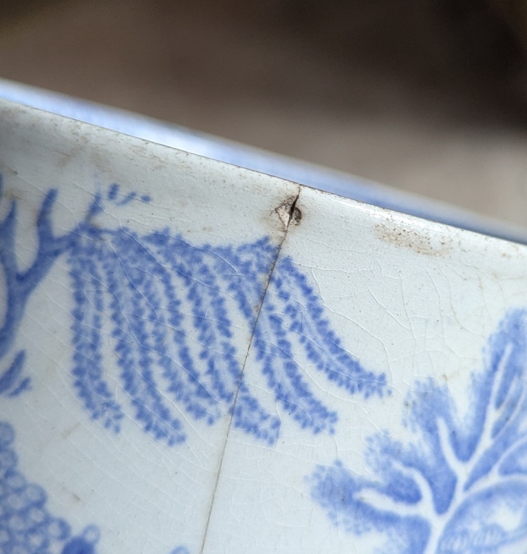
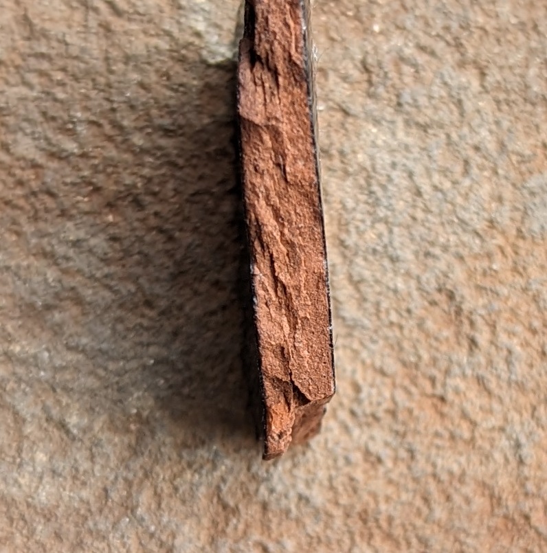
“Pint” indicates the measurement, “GR” is the regent – in this case “Georgius Rex” – King George V or VI, and the number “76” refers to the Weights and Measures authority in Salford and Manchester. George V or VI reigned one after another from 1910 to 1952 (with the very brief – 9 months – reign of Edward VIII in between), and in this case the royal cipher refers to George V, who reigned 1910 – 1936, providing us with a lovely date for when the pint pot was in use. As to which pub it was used in, alas, I cannot answer, but the fact remains that at some time between 1910 and 1936, in a pub in Glossop, people drank beer from this mug. And actually not for long, it seems – there is very little wear on the base, indicating it was in use for a short time only, and then it was thrown away whole, rather than after it was dropped and broken into pieces. That’s an odd thing to do, but I think I know why. Looking closely, there is an old hairline fracture – discoloured by the soil – and starting from this minor chip on the rim; I wonder if it was dropped or banged – enough to cause damage but not enough to fragment it?
It caused a fracture, but not a complete smash.
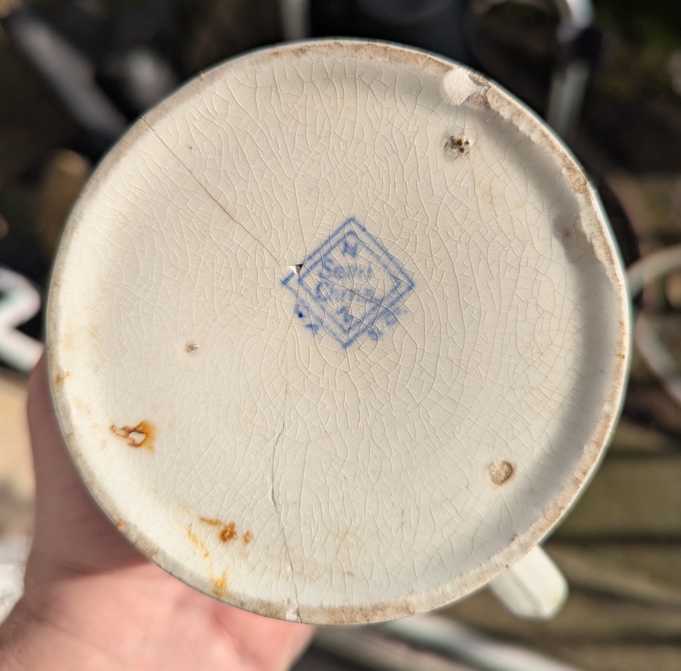
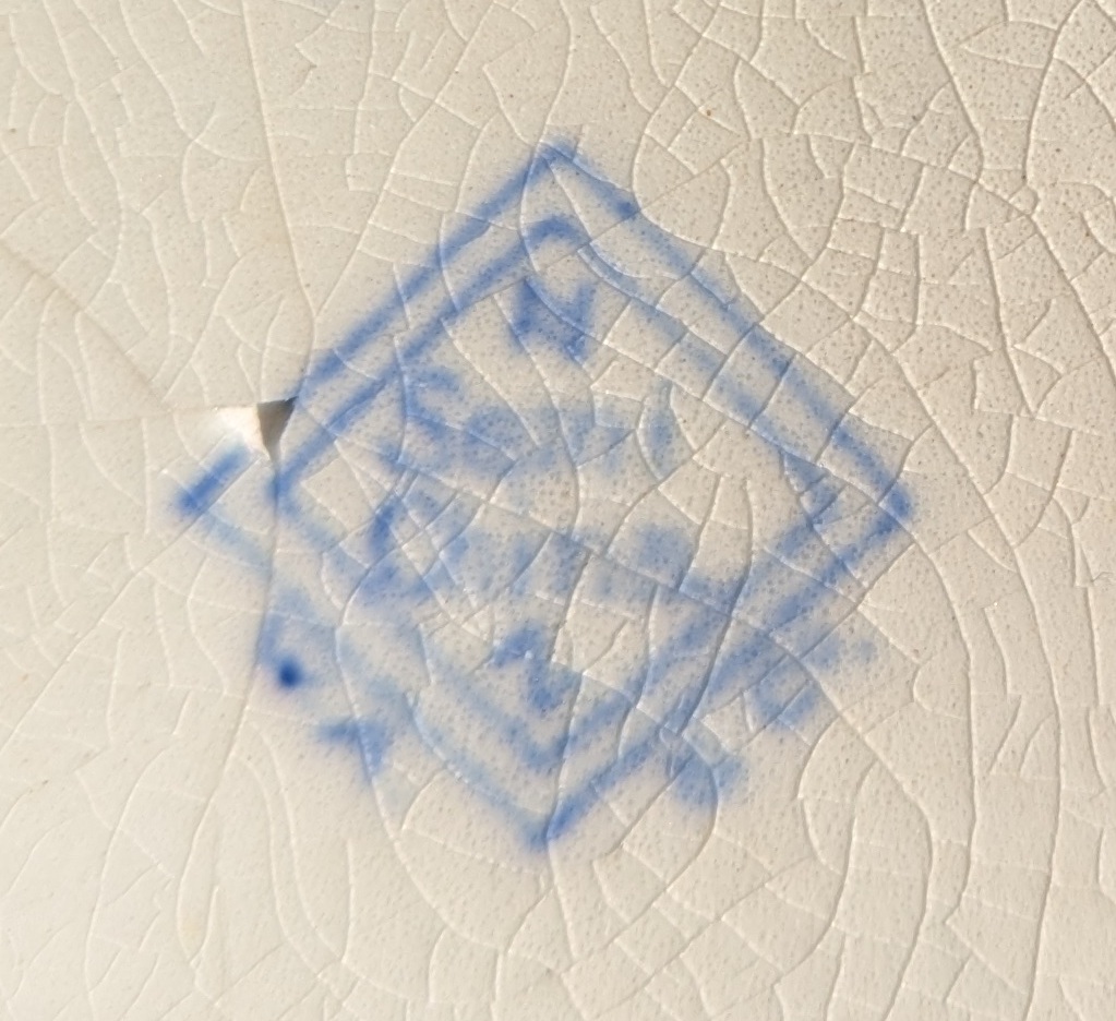
The pub, seeing the damage, chucked it away into the dump, only to be dug up 100 years later by the aforementioned schoolboy. It also has the makers mark on the base, which gave me another tingle!
Very blurry, it took me ages to work out what this says!
With the eye of faith, squinting, and on my third glass of stuff that cheers… it reads “Semi China”, and says “W A and Co” around the bottom of the lozenge. Presumably the other letters refer to the shape, and decoration type, etc. Anyway, it was a lead, and something to chew on.
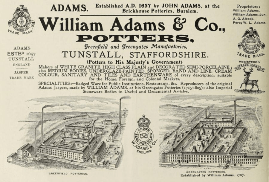
“WA and Co” is William Adams and Company, a pottery manufacturer that operated between 1657 and 1966 in the heartland of the Staffordshire Potteries.
The image is stolen from the wonderful, and truly fascinating, thepotteries.org – so much information you could need about Staffordshire Pottery. A genuinely amazing resource.
They specialised in making, among other wares, ‘Semi China’ – a cheaply produced alternative to Bone China – it’s earthernware, but cleaner and whiter. The company was eventually taken over by Wedgewood, and stopped manufacturing by the 1990’s.
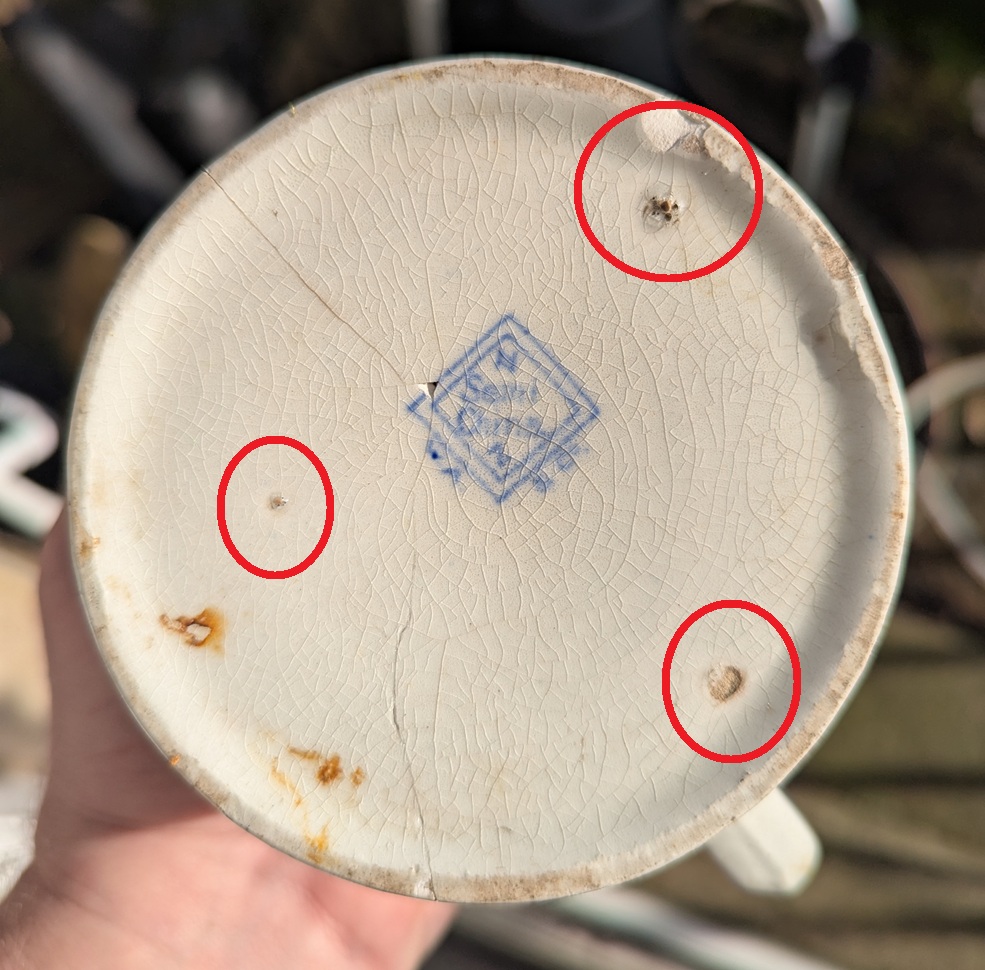
Also connected with manufacture are these marks on the base:
The joys of Windows Paint once more!
Three smudged holes in the glaze in shape of a perfect equilateral triangle, and a sneak peak into the way the mug was fired. When a glaze on the outside of the mugs surface is fired, it becomes a liquid glass, and then cools into the shiny surface. However, if this surface comes into contact with another mug, pot, or even the kiln wall, it will fuse onto that, essentially melting into a lump. in order to prevent this, objects to be fired are stacked in a particular way, and are separated by what’s known as ‘kiln furniture’, in this case a ‘stilt‘, which provides the minimum amount of contact between pots – simply three tiny points. The mass production of these cheaply produced vessels meant that the stilts are reused to the point of them being knackered, and less care taken – hence the wide jagged holes. However, stilts are used even on the finest pottery, only you can’t see the holes so easily.
So there we have it, a 1920’s pint pot from a pub in the Glossop area.
Right, that’s all for this time. There’s lots going on at the moment, but I couldn’t let a great post like this just wait! I want to thank Stanley for this article, though – it’s all his. The mug itself is now ‘safely’ back in his hands – a truly wonderful piece of history, loved, and back on the shelf. Thank you, S old bean… see, I told you I’d put it on the website and make you famous!
Until next time, look after yourselves and each other, and I remain.
Your humble servant,
TCG
*For the record, I cleared it with his parents before publishing this article – thanks Emily & Ant, & E!
What Ho! And a happy New Whatsit to you all, yes, even you Mr Shouty-Outy, even you.
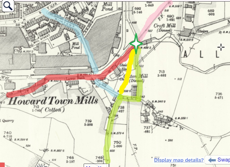
So, I was wondering down Cliffe Road in Whitfield the other day – actually on my way to Lidl, since you ask, and yes, to buy a bottle or two of the stuff that cheers… amongst other things (mainly cheese, if I’m honest). The road dives steeply down, and then takes a left turn at the bottom, and leads past the new build houses on the old Velocrepe site and onto Milltown. Now, I’ve always found this stretch of road very interesting. The main road from Chapel en le Frith to Glossop (and beyond), and thus Anglo-Saxon in date, it originally seems to have carried on straight, where it joined The Bank – the medieval/Post-Medieval track coming from Simmondley to Glossop – and together crossed Shelf Brook via the foot and road bridge at the entrance to Shirebrook, but was presumably then a ford or basic bridge. The route of this track was altered when a mill was built here, probably in the 1780’s (dates are a little fuzzy), and a mill pond put where it once ran. The newer route was/is to the right, and then down, past some mid 19th century houses there. Here, this carefully and skilfully annotated map explains it better visually than I can with words:
Green – Cliffe Road, with the right hand kink, and then straight ahead. Blue – the left hand late 18th/early 19th century extension to Milltown. Red – The Bank, the road from Simmondley to Glossop. Yellow – the original route of Cliffe Road, moved when the mill and millpond were put there. Green Star – the location of the crossing over Hurst Brook (a ford or bridge). Pink – the route from the bridge to Glossop.
But here I am again, getting distracted! This post is not about the tracks… well not as such. But rather, what such tracks were made from. The earliest tracks were simply mud, and were impassable in the rain, or with winter blowing cold, and Glossop was notorious for its frankly crap roads, which would have been patched and ‘surfaced’ with rough stones as and when it was needed, the remains of which can be seen occasionally be encountered peeking through the tracks where it has been worn.
I’m not going to go into the history of the roads in the Glossop area, as it has been covered in detail elsewhere (Glossop Heritage Trust), but in summary. it is only with the advent of the Turnpike Roads in the late 18th and earlier 19th century that Glossop finally got some ‘real’ roads. These high quality, well built and maintained, turnpike roads were paid for by a private consortium which recouped the money by charging a toll to travel on them. The introduction of these toll roads changed Glossop permanently, as it meant that the vast economic potential of Glossop’s mills could be fully realised; prior to this, mills were restricted, as it was difficult to get your finished cloth out, as well as raw materials in. Once this was problem was solved, the full brunt of the Industrial Revolution could be unleashed, bringing with it all the positives, and negatives, of this turbulent time (and if you know me, the you’ll know I’m essentially a hobbit, and so I think it was all a huge mistake!).
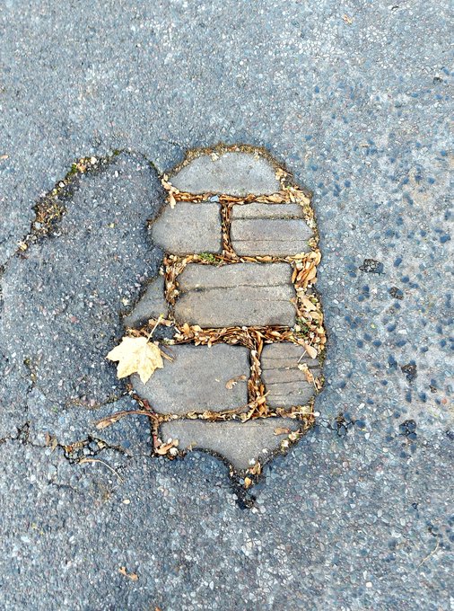
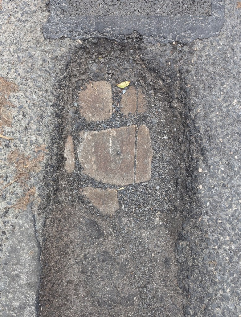
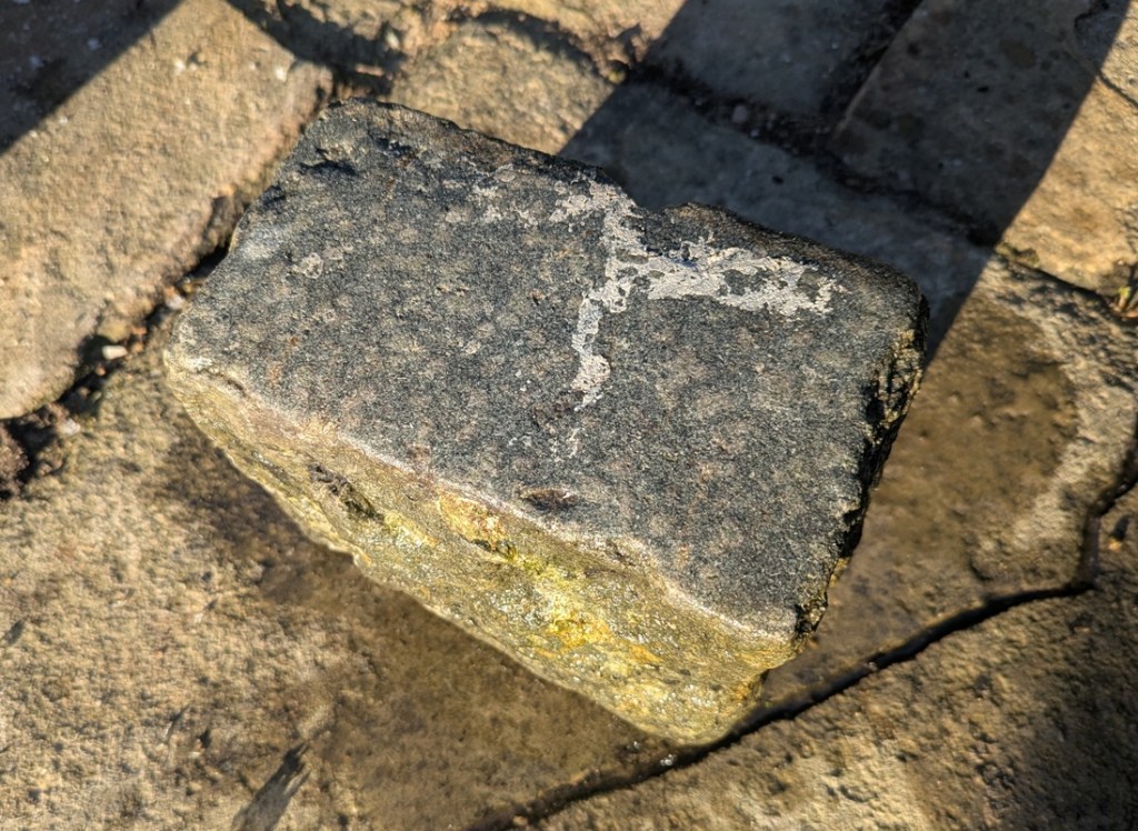
So, there I was, wandering down the bottom of Cliffe Road (in blue above), when magically, beneath my feet I saw this:
Peeking through, the past – always with us, sometimes at our feet.
The woeful state of the roads here in north Derbyshire, had revealed the original road surface; ‘What ho, setts!’ I thought.
So what are we looking at? This is the original surface of the road, dating to the time when this sideways step was constructed in the early 19th century (the datestone on the house at the bottom there reads ‘1815’, which is perfect). These are the setts that made up the road itself – a sett, which is deliberately shaped by human hands, rather than a cobble which is natural product and can be picked up off the beach. The fact that each one of these was shaped by hand frankly blows my mind! What a tedious, tiring, and unpleasant job that would have been, day in, day out. And how many 100’s of thousands… millions, would have been used in Glossop alone? Frightening stuff.
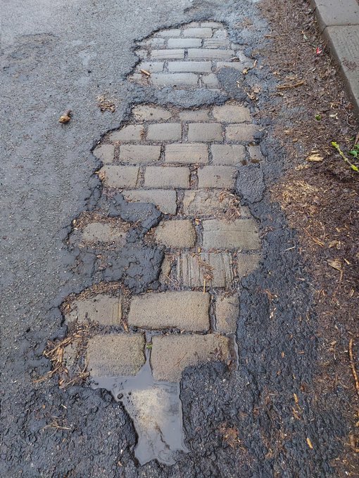
As you wander about Glossop, you can often encounter these sneaky little portals to the past, and I like to stand on them, imaging what stories they could tell. I also take photographs of them… what’s that? Hmmmm?… “I say, TCG old chap, you couldn’t show us some photographs could you?”. Well, I’m glad you asked, old bean, because I have few I could share!
These were on Wood Street
Shaw Street
Gladstone Street
The reason that we can see this is that the modern tarmac can’t get a good grip on the smooth surface of the Setts, and it simply peels of over time. They tried to solve the problem by scoring deep lines into the stone, but that doesn’t seem to have worked, either!
The scoring must have been done mechanically.
Occasionally, when there is a problem and the road need opening up, they have to pull up the setts, and you can can see how they were laid.
King Street
St Mary’s Road – you can see the setts just below the surface
Charlestown Road. Note the setts here are sitting on a bed of cinders and chalk.
And, of course, you can sometimes get lucky with the spoil from these excavations, and find a piece of pottery… obviously you can’t have an article without pottery!
Lovely – banded ‘annular’ Industrial Slipware. In this case, it dates to not later than 1850’s.
Also, this provides us with a terminus ante quem, meaning that the pottery could only have been deposited before the road was laid down, which is the case of St Mary’s was mid 19th century, or slightly earlier. Wonderful stuff!
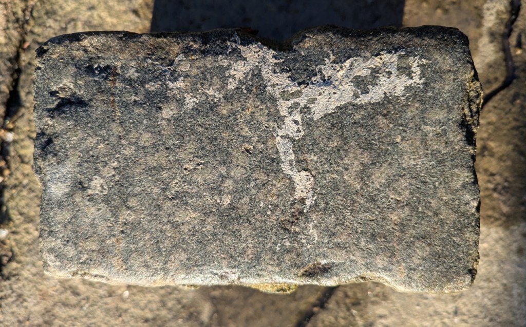
And of course, sometimes, the setts roll out of the spoil heap, and into… well, let’s not beat about the bush – my garden. It seems such a shame to just let them disappear into the truck and be driven off to a landfill somewhere, or to be used as hardcore for a new road. That saddens me greatly. So occasionally, they – magically – roll into the garden. Uphill. And sometimes over great distances. Following me home, if you will! And I can tell you this, they are heavier than they look!
A King Street Sett, a lovely grey colour. I think it had paint spilled on it as some stage.
It measures 7″ x 4″ x 5″, and has a smooth even surface. Hamnett suggests that King Street was laid out in the 1840’s and 1850’s, which makes sense.
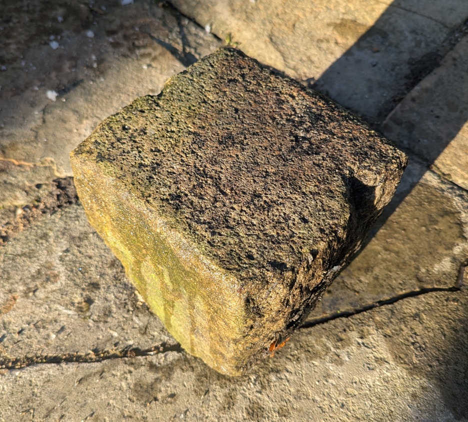
Turnlee RoadA more coarse surface.
Measuring 7.5″ x 7.5″ x 6.5″, the Turnlee Road sett is bigger, and has a rougher surface. This one is older, too, as it was presumably laid in the 1790’s when the turnpike road was put through, and is thus a real piece of Glossop’s history: who knows who and what travelled on this surface.
The King Street stone seems smoother, and thus more worn, than the Turnlee Road sett. This is odd – surely Turnlee would have seen much more traffic than King Street? But the differences may be explained by the location of the stone within the road surface; King Street was taken from the middle, whereas Turnlee was, I seem to remember, came from the edge of the road, where presumably no traffic would pass. It might also be explained by different stones being used – the Turnlee stone looks almost like a hard-wearing granite, whereas King Street seems more like a local gritstone. But I admit I am no geologist, so if anyone knows any better, please do shout out and correct me.
These are not the pretty bits of archaeology; the fancy buildings, the lovely pottery, the flint, the burial mounds, the Roman fort. Instead, this is simply the nuts and bolts of it – a road surface. And yet it has that vital link to the past, that important accessibility, that allows us a glimpse underneath the modern, and for that, I find them endlessly fascinating.
Right-ho! That’s all for now. My only New Year’s resolution this year is to publish more on the website, but to make the articles smaller, and thus quicker to write. I have another almost written, so I’ll go with that soon, and I’m working on all manner of other things, too.
Until then, though, look after yourselves, and each other, and please do get in contact with any thoughts or comments.
What ho, wonderful folk! Apologies for not publishing something sooner than today… truthfully, I have been a little overwhelmed and burnt out. Recent events have caught up with me, and I’m tired and somewhat sore; nothing a breather couldn’t fix, but sometimes it all becomes a little too much – please do listen to your bodies and minds, as they will often steer you on a correct course. Anyhoo, I’m back, and happy to be so. So here we are, with a long overdue post.
Last March, I went on a little Wander with a friend and family (hello GW). We had set off to do the first Where/When Wander, but having kids with us, we ended up playing around in the land by the allotments and behind Dinting Station. Aside from the fact that the area is interesting from a historical perspective (being connected with Dinting Station, and filled with old bits and pieces), it was also the location of the old Dinting Railway Centre/Museum. I vaguely remember visiting the museum several times as a child, and I recently bought a vintage guidebook on Ebay to try and fully remember what it was I went to.
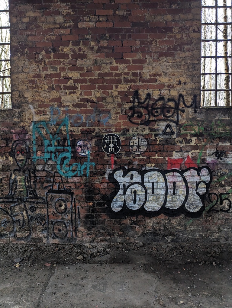
The centre finally closed in 1990, and whilst all the trains and exhibition pieces moved elsewhere, the infrastructure – rails, and platforms, and buildings – all remains (here is a good article about the museum’s rise and fall, and there’s loads about it on the internet). Central in this wasteland – or forest of Silver Birch – the Engine Shed still stands, alone, derelict, and graffiti covered.
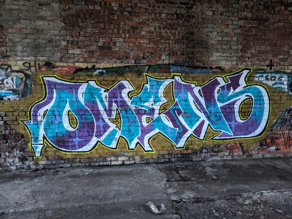
Here’s what it looked like in 1967, before the Railway Museum…And here’s a similar shot, nearly 60 years later, and after having been a museum in the meantime. Blimey! Honestly, the building is in there. Our old friend Boof makes an appearance, here represented by his/her older tag, and a newer (2025) bubble piece. His/her tag is all over the site.Some of it is quite good, this piece in particular ‘OMENS’ (strangely unsigned, presumably Omens is their ‘tag’), and this one……are very artfully done. Love the window in the background/part of of this one. So this is interesting. Because I am that sort of person, I knew this was something when I saw it. Rather bafflingly, this is the sigil of Foras, one of the 72 demons mentioned in the 17th century Lesser Key of Solomon. Apparently he was the president of Hell, and was associated with precious metals, logic, and lost things. Quite why his sigil is painted on the wall here is beyond me; teenage rebellion or demonic invasion? You decide.
Anyway, comparing the photographs of then with now is really quite interesting, and shows just how quickly nature retakes land back, even heavily used and industrialised land such as this. Give it another 100 years, and there will be very little recognisable, 500 years and it’ll need an archaeological excavation to make any sense of the site; understanding site formation processes like this is vital as an archaeologist, and our case study is right here.
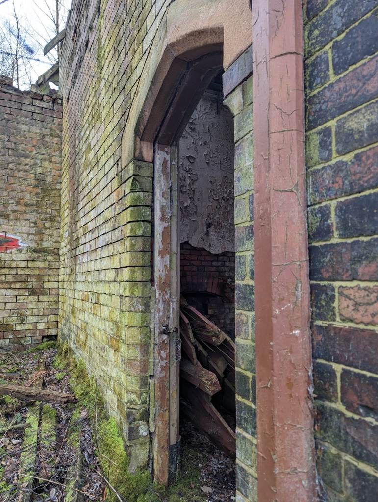
But today’s article is less about the centre, and more about a single aspect of the site. As generally happens, when a building is left derelict and unused, it slowly breaks down, and this is the case with Dinting station’s southern waiting room. Built in 1884, when the original 1848 station was rebuilt, you can see it from the train behind a fence; overgrown, derelict, absolutely terrifying. However, I didn’t know you could access the station from the back, via the patch of ground we were exploring. Well, I mean to say… one cannot simply say no when such gifts are presented to one! I had a brief explore! Brief because: a) I was probably trespassing, although it is very unclear to be honest (and I was by no means the only person there that day… or even that hour!), and b) we had children with us, and the place is phenomenally dangerous, with broken glass, falling masonry, and Jove knows what else. It was also going dark, and, I’m not going to lie to you, the place is spooky! Before we go on, I am also going to insert a cautionary statement here: I absolutely do not endorse you going to the place to look, and in fact recommend you don’t. So I took a very few, mostly terrible, photographs, and scarpered.
The station building from afar… the Silver Birch trees are amazing in this photo – and I actually find them frightening here. Random brickwork, and an odd framed shot of a corner with shamfered edged stone. Look, I had a quick look around, and then legged it! I wasn’t taking my time with perfection! Lovely Stoneware bottle; possibly a large ink bottle, but I suspect it is something more industrial – a chemical or oil, perhaps. The whole area is filled with burnt cinders and rubbish, amongst which are many interesting finds. It’s a beautiful building. Or at least could be. These windows are lovely, but then through them you can see sky through the roof. How long does this place have left before it all collapses? Who knows. The doorway, with what looks like a Cheshire sandstone lintel. I honestly feel something should be done about preserving this building. I don’t know what could be done with it, but something more than just leaving it to rot… surely?
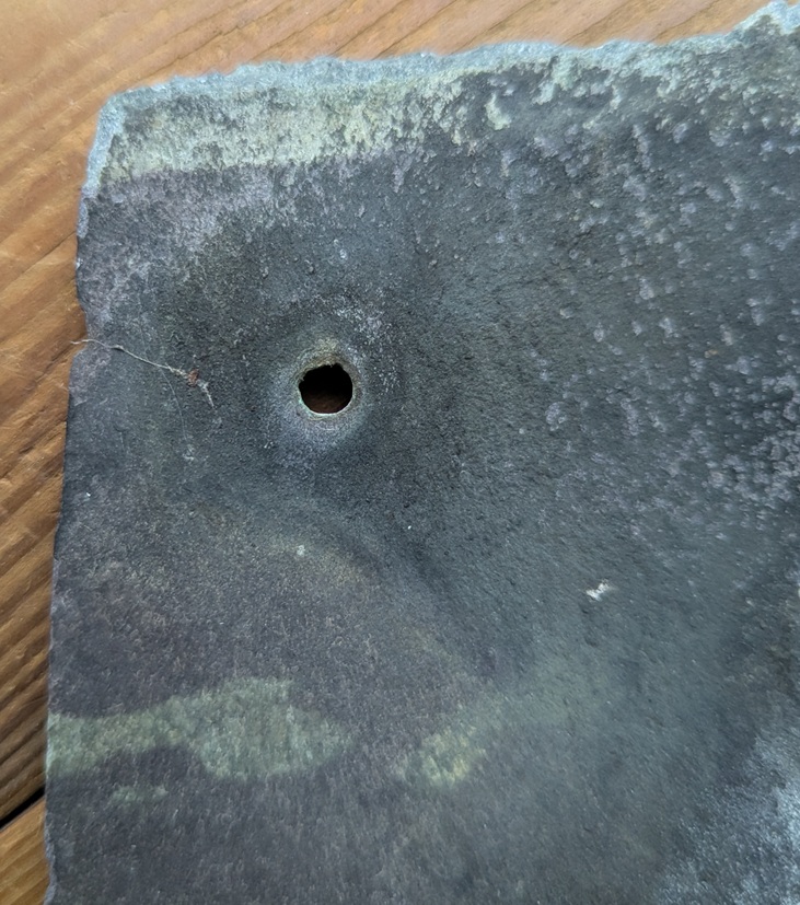
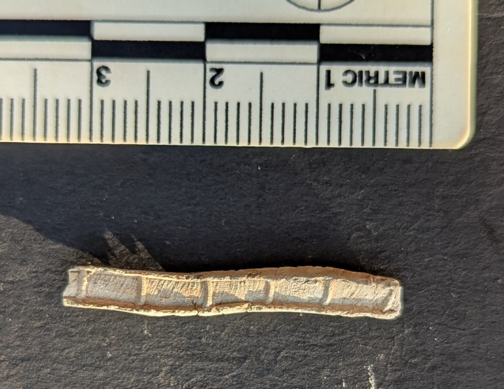
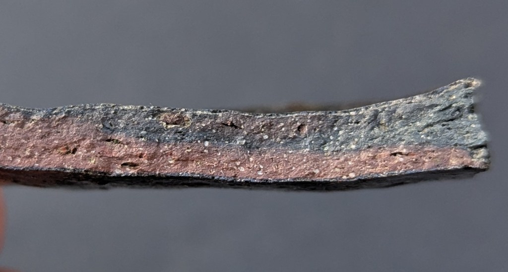
So I had a quick look around, as you do, and in doing so, I noticed that the whole roof of the exterior platform area had collapsed, seemingly as one, and the floor was littered with rotting wooden roofing and broken slates. And then I saw it… a single slate seemed to have survived intact-ish. I pulled it up and thought… I say, here’s a nice little blog entry! And so here we are:
Amazingly, it had both copper nails still in-situ, and whilst it has broken a little at the top, it allows us to see how it was made.
The rougher edges are very characteristic, and I think I can see the result of individual hammer blows. Possibly.
Geologically, slate is dense, and was laid down in thin layers, which allows us to quarry it and split it into relatively thin sheets using a hammer and chisel. It is further shaped using a soft hammer whilst over hanging a hard edge (or later using a machine, although still hand held). There is a fascinating YouTube video here that shows the whole process, for those who like to know… it makes it look so easy! This gives it the characteristic nibbled edges.
The different areas of dark colouring on the slate itself is the result of differential exposure to smoky polluted air, with the bluer/greyer bits being protected by wood or other slates.
The holes to take the nails were made probably with a metal punch – a single blow delivered from a hammer on one side, and the force of the strike spread and created a characteristic ‘exit wound’, much wider than the entry.
The ‘entry wound’. I wonder if these have been partly drilled before being punched?The devastating ‘exit wound’.
Looking at the nails themselves, they are fairly standard mid/late Victorian copper nails, hand finished, and square in section.
I honestly love these things. The back side, showing the nail through the hole.
These wonderful things seem to be attracted to me, and I find them all over Glossop, or maybe it’s just I’m always looking down (I’m going to be Richard III-like before I’m 60 at this rate). And, as I can never resist them when I find them, I have quite a few, here in CG towers. I say “quite a few” like it’s 10 or 12. I actually have hundreds of the buggers, hiding in labelled bags, naturally, and hidden in drawers, but shhhhhh… don’t tell Mrs CG, this sort of thing makes her twitch. I wrote a little about how they are made, here, in this article, 8 years ago… man, do I feel old!
What a difference Welsh roof slates would have made to housebuilding. As I type this, I sit under a roof made from locally sourced gritstone (I think I can see the quarry from my house); each roof tile is an inch thick, solid stone, and I bet the whole roof must weigh somewhere in the region of 5 tonnes, with each individual tile moved up and positioned by hand. I watched them do it when my roof was re-laid, and it took a long time. Now think of the slate; each tile weighs a tenth of the stone one, meaning more could be carried up and laid quicker, it costs less per tile, and overall does the same job, but at a fraction of the weight of the roof, meaning smaller beams could be used. It’s no wonder that Welsh slate tiles took over almost immediately, ironically being brought here – safely and quickly – by the train. In fact, you can use the presence or absence of a slate roof as a quick and easy way of dating the buildings here in Glossop: stone roof, built pre-1850(ish), slate roof, post 1850(ish)
So there you go. Right, I have another article almost finished, and I’ll try to get it out to you before New Year, but I’m not going to make any promises! Just know that I’m always trying, but sometimes life gets in the way of this, what I want to actually be doing with my time!
Before I pop off, the new Where/When is now available – woohoo! #8 – The Bullsheaf Shuffle.
This edition is a great one! Two smaller Wanders to tickle your festive season.
Two Wanders, both starting and finishing at a pub in Old Glossop, and neither very long, but all filled with history – medieval field systems, prehistoric remains, Ordnance Survey benchmarks, Roman roads (or not!), post-medieval trackways, Georgian buildings, a Victorian rifle range, and bits of pottery! A perfect stocking filler, available from here, or from Dark Peak Books, in High Street West, Glossop. All back issues are also in stock again, too, so knock yourself and grab a couple!
Right then, I’m off. Lots to do, annoyingly – the Christmas season is so wonderful, but equally is a real faff! As is work… and real life. However, until we next meet, please do look after yourselves and each other – you are all very important, even if you don’t know how, and to whom.
What ho! Autumn is here… it was cold this morning, and leaves are already turning, and hopefully this article will be published on the Autumn Equinox. Probably. I mean to say… that’s what I’m aiming for*. It’s been a very weird and stressful week or two for a variety of reasons too complicated to go into here, but in the spirit of hopefully moving on, I present this short(ish) offering, which I hope satisfies at least the craving for pottery.
*Ok, so I failed… but only by two days.
So, I have a large inglenook style fireplace in my house, and the hearthstone in front of the wood burner in said fireplace has, much to the annoyance of Mrs CG, become something of a drying and sorting zone for the bits and pieces I have found along the course of my normal life! And precisely because the nights are getting colder, and the burner might need to be used soon, I am forced to clear up the archaeology. Well… hold my glass of stuff that cheers, as the saying goes, the challenge has been accepted.
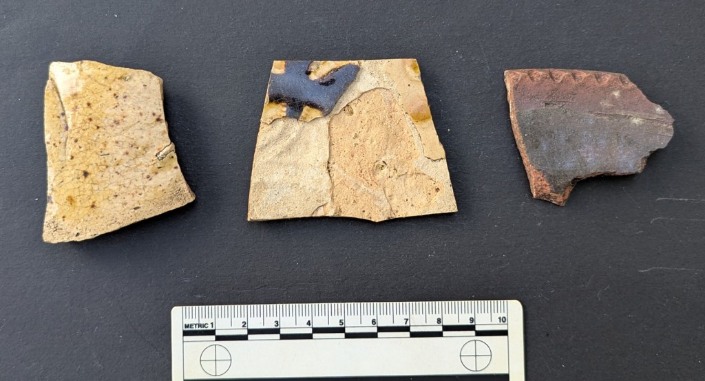
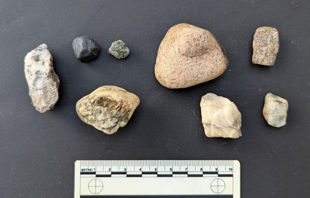
There they are, on the hearthstone.
It’s interesting in that it represents a sort of snapshot of the kinds of things I have found very recently, and actually from all over, too, not just Glossop. I’ve also tried to keep to my new rule of only keeping things that I find interesting, or that you might find interesting – so no more simple and plain Blue and White Transfer Printed Ware or similar. And in all honesty, I won’t keep some of this, and I’ll return it. Anyway – here we go.
Lovely stuff.
First up, a Derbyshire Salt Glaze Stoneware bottle base, with a diameter of 8cm – you can see the ‘orange-peel’ effect of the salt glaze on the exterior. It probably contained some form of drink, perhaps alcoholic, and although they often contained ink, too, I think it would have been to nice for that, with the fancy groove running around the bottom. The interior is also glazed, and has wonderful grooves, evidence of how the bottle was hand made on a potter’s wheel.
The rising of the grooves on the inside, showing where the potter pulled the clay into the bottle shape.
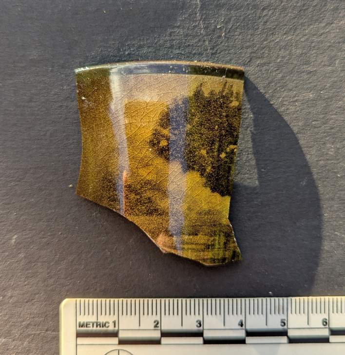
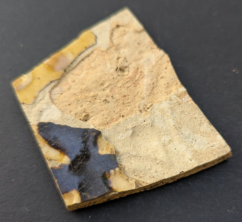
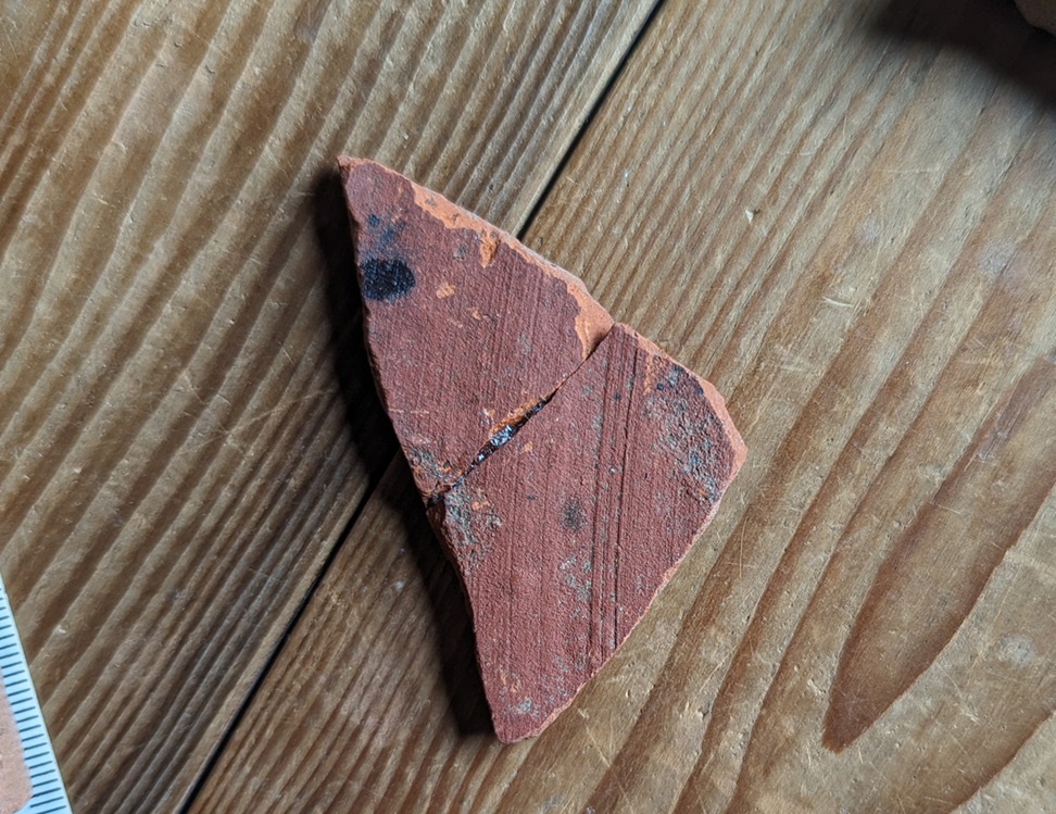
Next up is this lovely teacup sherd in an unusual colour. Measuring 9cm in diameter, it seems to have straight sides, and is decorated with what might be a tree in front of stormy clouds, or perhaps just clouds, in a brown and yellow transfer. It’s probably 20th century in date, and it’s odd, but I quite like it.
Found in Alexandra Park, Oldham, having been dug out of a badger’s sett in the woods.
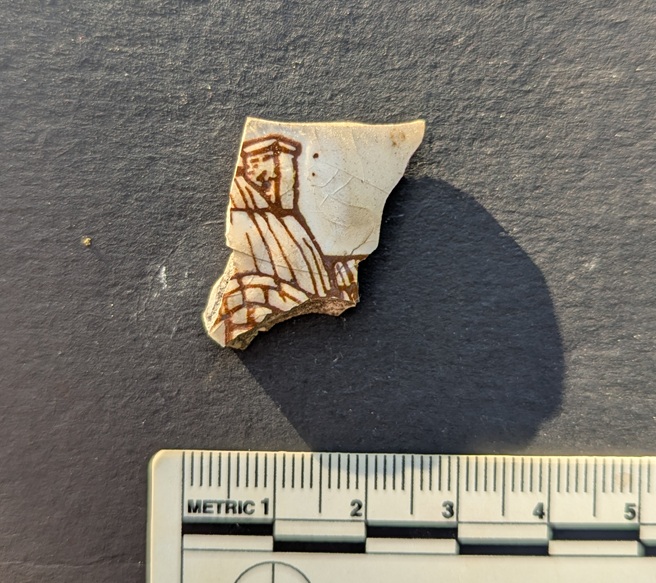
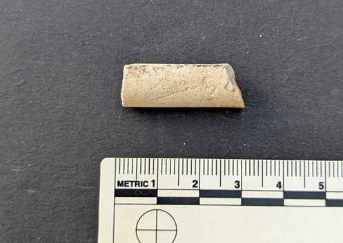
Next up, a chimney…
A tiny sherd of transfer printed ware, dating to the late Victorian period, and showing what was probably a cottage scene, of which the roof and chimney is the only bit to survive. I couldn’t leave that behind, could I? Found on the footpath by Pyegrove, Glossop.
Next we have a…
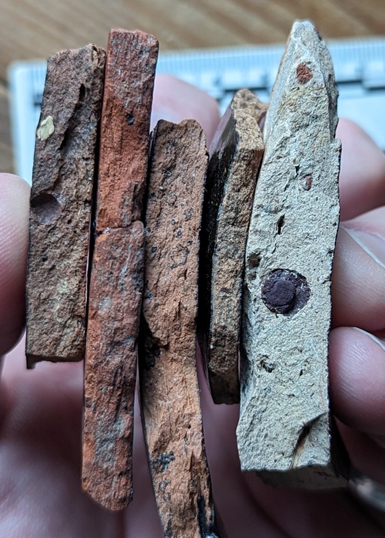
…copper roof nail. Found at the top end of Whitfield Cross, the result of someone having roof work done, with the old nail being pulled out and the slate replaced. Contrary to what I had thought, the nail is not bent accidentally, but rather it is driven into the wooden battens a short distance, and then bent over deliberately in order to secure the slate in place. Lovely stuff; I love the colour, but also the square shape in section of the shaft. I wrote a little about them and how they were made, here, and oddly they seem to seek me out – I’m always finding them in the street, and I have hundreds!
Next up, a Victorian clay pipe stem:
Awful shot, but I think I am due to get a new phone soon…
The pipe stem and mouthpiece is to the left, and the bowl should have been to the right – the bit that sticks down is the spur of the pipe. This sort of thing.
Interestingly, the spur – designed to keep the pipe from rolling around and to keep the hot bowl from burning surfaces – has a circular (or annular) maker’s mark or decoration on it. I have no more information to offer, sadly, but I think it is quite a common marking. Love it!
I also love this:
I know, I know… I haven’t washed it!
A lovely sherd of Victorian Hand-Painted pottery. You can see (through the mud – apologies) the individual brush strokes that make up the delicate blue flower that once adorned a probable . I have the next Rough Guide to Pottery planned that, among other pottery types, looks at this Hand-Painted stuff; you lucky people, you! Anyway, enough of the shouting and cursing… this was also found on the Pyegrove path, as indeed was this next one:
I think this was well used and quite worn when it went into the ground.
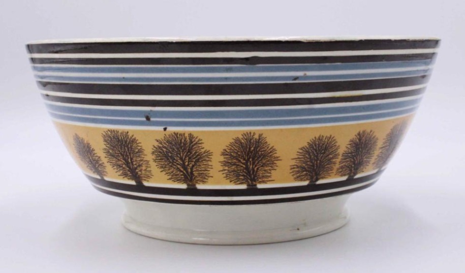
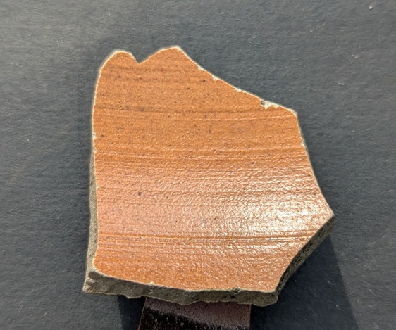
It’s a sherd of Industrial Slipware, in a lovely pale grey colour, and, measuring a diameter of 14cm, it’s probably a rim to a Georgian/early 19th century Mocha Ware open bowl, perhaps like this:
Found on the internet and shamelessly stolen – you could have bought this lovely example from only $225, which is probably well worth it.
The next two were found on the track from Pyegrove to Old Glossop – along the track to Hall Fold:
Another rim sherd.
and…
And a bit of a body sherd – tiny, really, but characteristic.
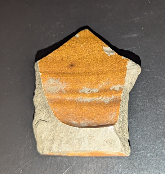
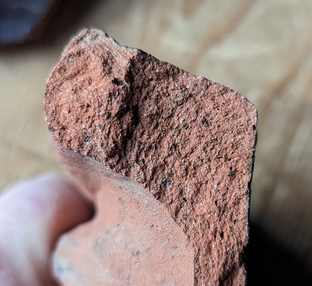
The first sherd is a rim sherd from a large open bowl or plate, and is in a 17th century Midlands Yellow Ware. It’s impossible to get a rim diameter – despite being a rim sherd – because it is such a small fragment (thus we see the limits of the Rim Chart). However, it is chunky and well made, so it is likely to be large, and as it is a relatively fine fabric, so it is likely to be later in date. Probably.
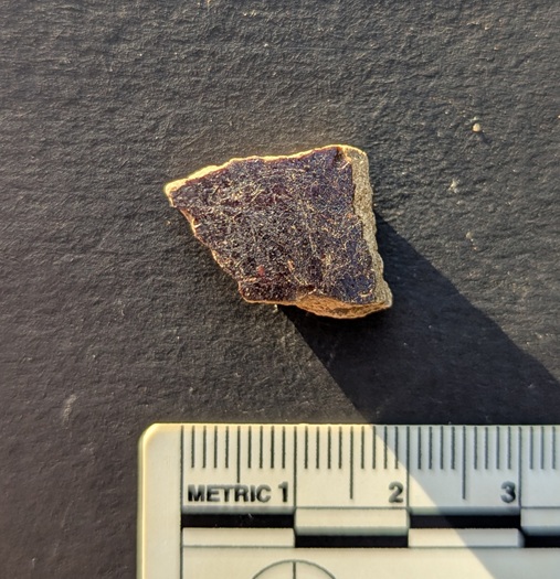
The second sherd is a fragment of a Manganese Glazed vessel. Honestly, I have no idea about the shape – most are open, rather than a closed shape, and this has glaze on the interior and exterior, which also suggests open shape. Date… 17th to very early 18th century.
Both of these are lovely bits, and really bring home the age of these trackways that I keep banging on about! I have a future blog post planned… don’t worry.
Next is this wonderful thing:
The low evening sunlight really brings out the features.
A single piece of lead came – window lead. This lead came held the small pieces of window glass together to make up a window, and is made by squeezing the lead through a former, whose cogs leave grooves in the lead. It seems that, as a rule of thumb, the smaller the gaps between these ‘reeds’, the newer the came, and vice versa. So it seems that this piece of came is quite early – 17th, or possibly 16th century? It was found on the banks of Erwood Reservoir, near Buxton, along with a whole pile of other 17th century material (the subject of a future article, especially as it very much mimics the same material found on the valley sides around here). This is the fabric of a long lost farm, and I wonder who last looked through the glass it once held.
And to finish this ramshackle wander around my hearthstone, I present the following: a mason’s mark from the railway bridge at the bottom of the Hayfield Road (A624) at Chinley.
In the central larger stone.
Here’s what it looks like:
A rough sketch from my catalogue of mason’s marks in the area.
I realise that it’s not really a fireplace related thing, but I like this sort of thing, and so do most of you, and besides… I don’t know where else to put it! It’s one of several examples of this mark on the bridge, and has maddeningly resisted me taking a photograph for one reason or another. However, the other day we were travelling in our new camper van, and all the planets aligned, and I managed to get this snap! Whilst very similar, it’s not like any of the others in the area that I have documented, and whilst this is disappointing, it makes sense as there were hundreds of stonemasons working on building the rail network in the early to mid-Victorian period (the line here was opened in 1867). This whole area is interesting, and following the construction of the railway, the road system was monkeyed around with, with roads no longer connecting, or moved over and replaced by newer ones. I should explore it a little, who knows what might be uncovered.
In terms of mason’s marks, I’m still toying with the idea of a project that studies all the marks, to catalogue, photograph, and cross reference them. If anyone fancies coming with me on a few walks to make this happen – from Broadbottom to Longdendale, and then the Chinley Line, perhaps – give me a shout.
So, there you go, the Fireplace Finds Frenzy… I hope you enjoyed it.
More soon, honestly. But until then, I know I say this every month, but please do look after yourselves and each other; I have recently learned just how important this is, and in particular, you never know when your time is up.
Happy summer everyone! I hope the season finds you in good form… or at least not in actively terrible form. Having recently celebrated a somewhat significant birthday with a trip to Naples area – Pompeii and Herculaneum included – I returned exhausted, and filled to the gunwales with pizza, wonderful wine, and archaeology, which pretty much sums up my life, to be fair. I can heartily recommend such a trip, although it was a tad expensive, and I can now only just about afford to camp in my own garden!
Whilst I was there, I actually wrote a blog post about a Wander to the beach I made, and that I thought you might enjoy; this was meant to be it. But I haven’t finished it yet, obviously, and so we have to remain close to home today. I mean, it’s not quite as glamorous as Pompeii or the Bay of Naples, but Whitfield is just as interesting. Kind of.
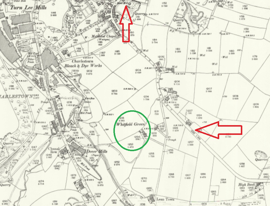
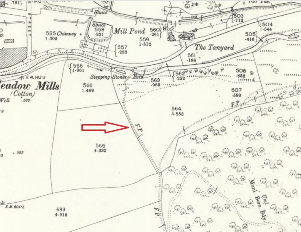
Anyway, I’ve often wondered about this place – Whitfield Green – a farm that is marked on older maps, but which is clearly no longer there.
For the sake of orientation, Whitfield Green is in green, The Beehive is just off the map, but indicated by the top arrow, and Derbyshire Level is indicated by the other arrow.
I mean, the building is clearly old, and is clearly marked Whitfield Green, but I can find absolutely no information out about the place. So I went exploring…
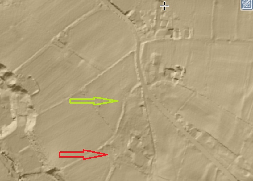
Firstly, the roads. The whole area around Derbyshire Level and Lean Town has been monkeyed with following the Whitfield Enclosure of 1813, so it is sometimes difficult to see exactly what went where before that point. Map work and physical walking helps, and it seems the road originally went along the lines of the red line in the map below – it continuing straight at Lane Ends Farm, instead of kinking left as it does now, and continues to Whitfield Green, thus:
You can see a hollow where the field edge is now, and it is visible on LIDAR.
The site of Whitfield Green is indicated by the red arrow, and the hollow trackway – now a hedge and fence – is indicated by the green arrow.
From here (with numerous branches, and marked in red below), this track would go under Lean Town, and then onto Gnat Hole, and then to Chunal – unbelievably, it was once the main route from Glossop and Whitfield to the south – Buxton, Chapel en le Frith, etc.! However, when the Enclosures happened, one of the stipulations in the act of parliament was the building of wide solid roads – hence we have Derbyshire Level, which, whilst incorporating numerous existing routes, was a totally new road – no wonder when you look at state of the roads at that point. In fact, so bad were the roads that Glossop historian Ralph Bernard Robinson, writing in 1863, noted that
“Glossop, till a comparatively recent period, was a place difficult of approach, and, in some circumstances almost impassable, owing to the nature of the roads. They seem to have no roads but such as the Romans, ages before, had made for them.”
This paints a very different picture of this area of Whitfield, and makes it seem that Whitfield Green was more than simply a farm in the middle of nowhere. I wonder.
So it is at this point, with the radical shake up of the roads that followed the Enclosure Act, that many of the trackways with which I am obsessed become obsolete, and so it is with the red trackway, the access track to Whitfield Green – it simple ceases to be needed as the new road that goes down to Lean Town was made, and a new access track came off it. This is the footpath you now walk down in order to get to where Whitfield Green once stood (marked in green in the map above). Kidd Road was once known as Whitfield Green Road, and actually, I suspect that it once went across the field and that this ‘new’ access path is in fact the old route preserved, once the whole area had been monkeyed with (marked in blue, above).
Indeed, Derbyshire Level, and the spur around Moorfield, combined with the Turnpike Road (Charlestown Road) meant that there were now new solid roads along which to travel, and thus the old muddy route below Lean Town and through Gnat Hole was no longer used, and the whole became footpaths. It also meant that new farms could be built, and it is at this point that I think Whitfield Green Farm was built, just to the north of Whitfield Green (circled in yellow above). It is still there, but is very difficult to see without being arrested for “acting suspiciously near an innocent person’s house”… again. It has a stone roof (so making pre-1850ish), but there is nothing that points to it being older that the first half of the 19th century, and I suspect that once the new Lean Town road was made in 1820, someone took the opportunity to build a new farm there.
We know Whitfield Green was there in the 1920’s, but no longer appears on maps from the 1960’s onwards, so presumably it was demolished between those dates. A pity, but there you go, such is the nature of progress. Thus, the timeline seems to be:
1720 (ish – maybe before, maybe after) – Whitfield Green built on existing track (in red), and also accessed via another track (Kidd Road, in blue)
1806 – Lean Town built on the same (red) trackway
1810-13 – Whitfield Enclosure Act, and thus…
1820 – New roads made, including Lean Town road, and access to Whitfield Green comes from that now (albeit via an existing track).
1825 (ish) – Whitfield Green Farm (the new one) built (in yellow)
1950 (ish) – Whitfield Green demolished
That seems to tally with what we know, but if you think differently, let me know – click the ‘contact’ button at the top, or leave a comment… I’m always happy to hear from you.
So what did I find when I went to look at where Whitfield Green once stood, I hear you ask. Well, I’m glad you asked, because I found:
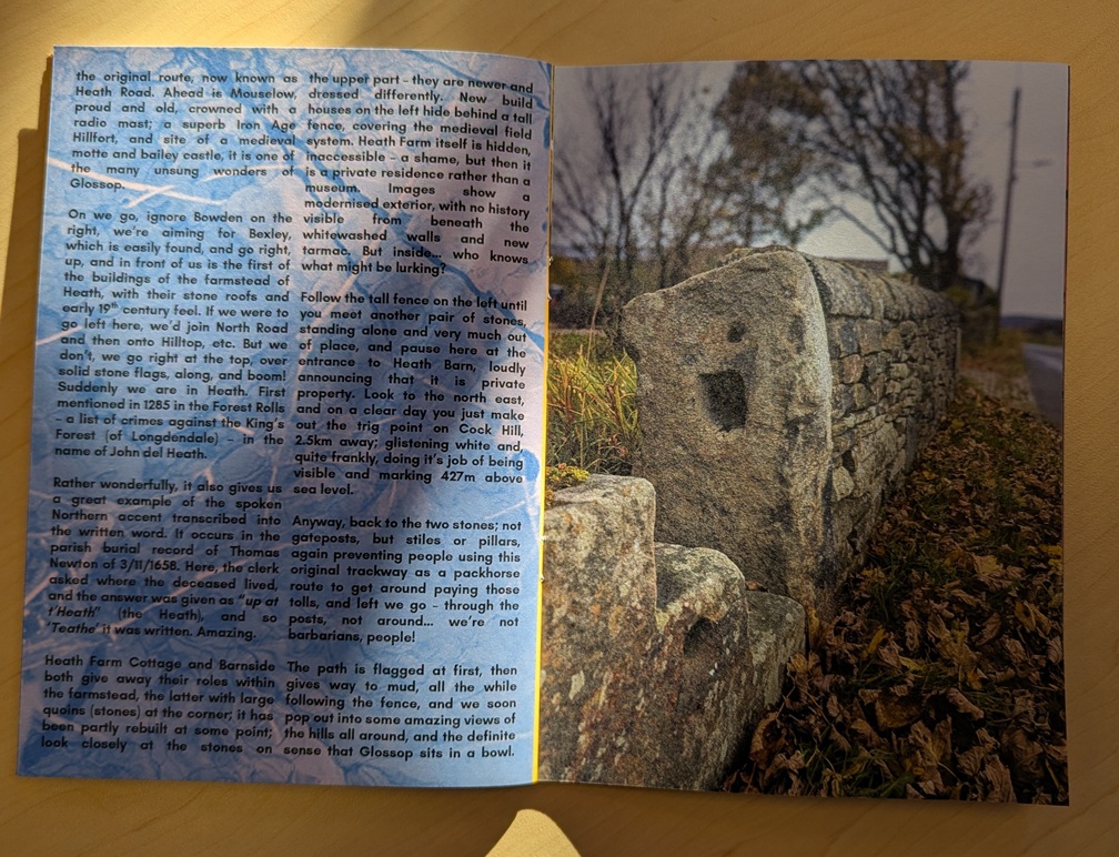
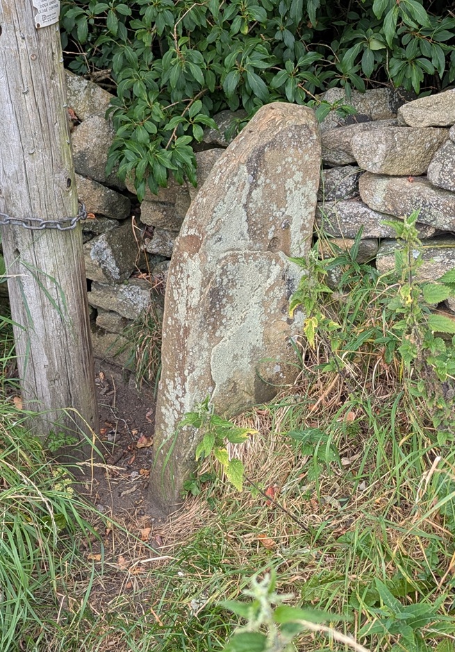
A stone stile. Lots of the paths around here have these, presumably to prevent anything other than foot traffic from using them. I wonder if they were put in when the newer – and toll paying – roads were created in order to stop packhorse trains using them. There are different types too, and I wonder if they were put in at different times.
Here’s where the Whitfield Green once stood, against this hedge line. Nowt there now.
However, look closer and…
Shaped stones in-situ. These have not been moved into this position, this is where they were, and are the remains of the farmhouse… although what part is unclear. And here is a stone-flagged floor. I wonder who – apart from the current farmer and their cows – stood on these last? They have to have been internal, so a part of the farmhouse proper, rather than the yard outside. Hmmm…More stonework; in the world of archaeology, 3 stones in a row make a wall, so…There’s also a huge pile of stone nearby, and whilst not a large farm’s worth of walling, I assume most of the rubble would have been re-used as drystone walling. And a lot of it has been shaped, and rather than it being the product of a removed drystone wall… we are looking at the remains of a farmhouse.
It was the flagged floor that really brought it home that this was actually once a house; I love that moment when archaeology meets actual lived life; spooky, yet intimate, an odd feeling. It would be great to have a proper scrape around and uncover more of whatever remains.
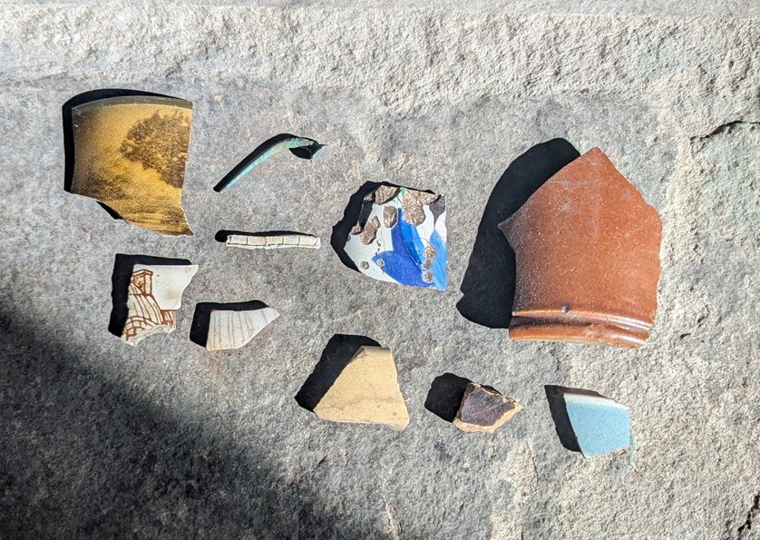
And pray what, if anything, did you find there, you strange, pottery obsessed, person, you? Well, I’m glad you asked that, too:
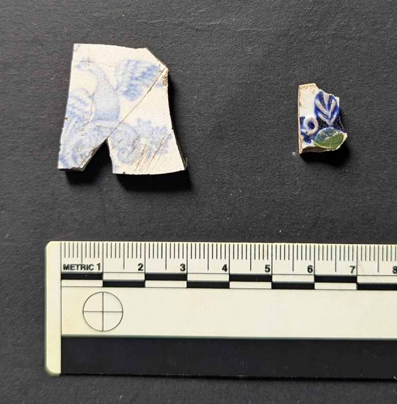
The expected ‘noise’ of Victorian pottery – Blue and White Transfer Printed, mainly (with some black printed), as well as one sherd of ‘Flow Blue’, and a possible sherd of Shell Edged. Left is a wonderful bird; Victorian, and not at all rare, but the phoenix-like image is lovely. Right is an odd one – moulded, so the decoration in 3d, it is highlighted in both underglaze (blue) and over glaze (green). Again, not rare, but not commonly encountered… and nice. Clay pipes… the cigarette butt of the Victorian period! I love them, but honestly… Stems and a bit of a bowl, nothing particularly interesting, although…
…the bowl has burn marks on the inside, evidence of the last drag!
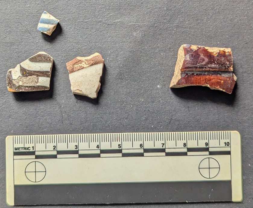
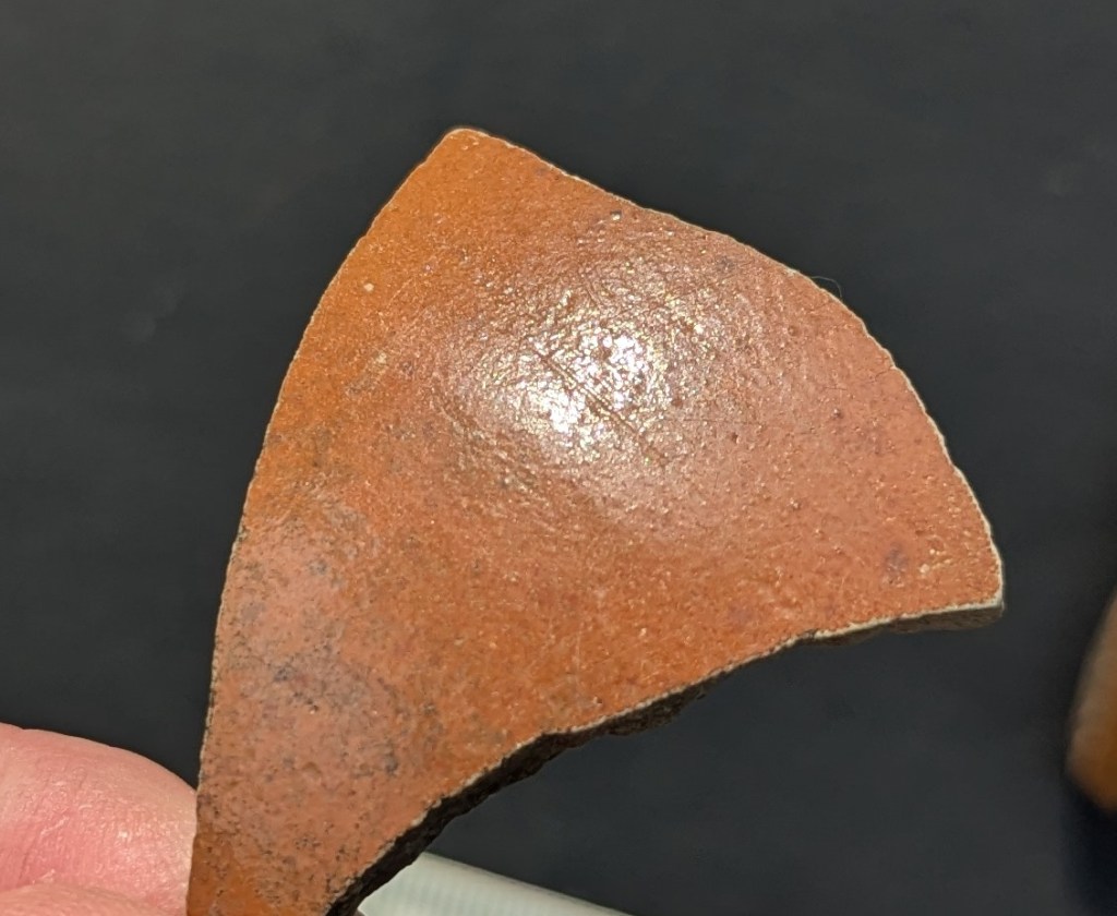
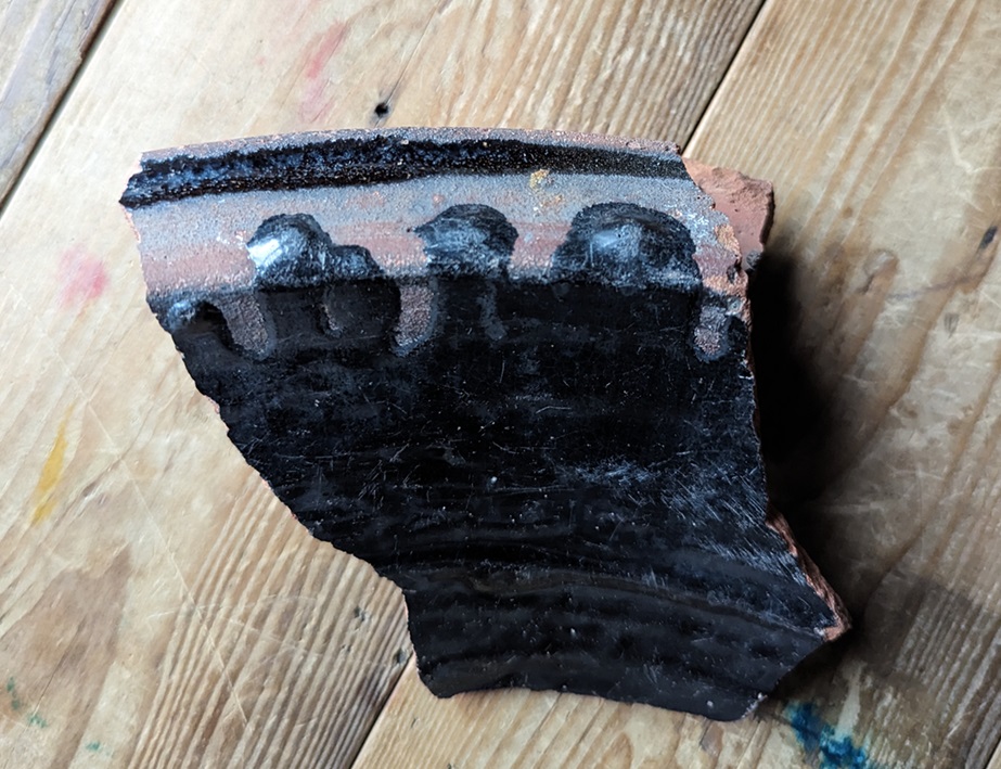
Left – 3 sherds of Industrial Slipware (1800-1900) – almost certainly bowls; right is a sherd of a Victorian ‘Brown Betty‘ teapot, still made if you feel the need (I do!).
Top from a Victorian blacking bottle.
So far, so Victorian. However, against this background there were several sherds of older pottery lying around:
Early 18th century Staffordshire Slipware platter – roughly 1700-1740. The underside shows a slight red slip, and a line made in the clay during manufacture, possibly the result of moving the leather hard pot – pre-fired – over a rough surface.
Then there is this lovely thing, and I am aware that ‘lovely’ is an entirely subjective concept.
Lovely… honestly!
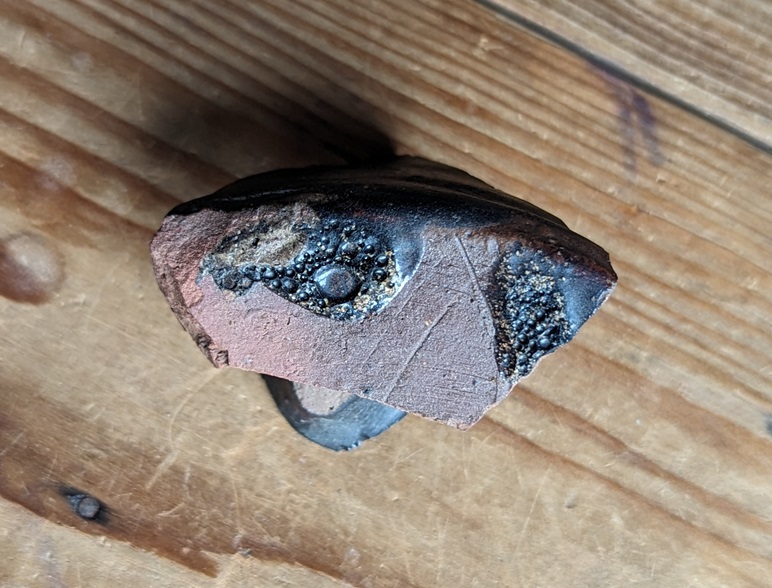
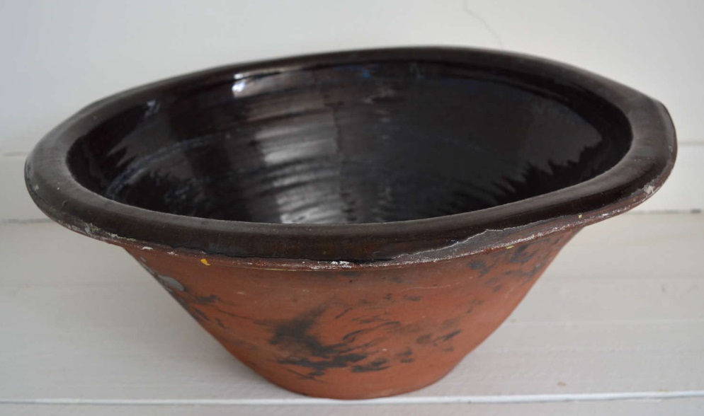
It’s the wide strap handle to a large cooking pot – this sort of thing:
Taken from here
The fabric is unusual, though – very hard, with a purple colour, and a black and white mixture of inclusions – it’s a sort of Midland Purpleware, almost Cistercian Ware, and not at all like the normal Black Glazed stuff that you associate with Pancheons. Lovely stuff.
Also, there is the brown stoneware. Some Victorian Derbyshire Stoneware, but also early 18th century Nottingham Stoneware:
The two handle fragments at the top probably come from a tankard, again early-mid 18th century, and the bottom left bit I think comes from a bottle. The sherd in the centre come from a strange shaped lid… I think. It’s odd.
And finally, I found this:
A ‘Tombac’ button; Tombac is an alloy that has a high copper content (80-95%) mixed with zinc.
Shiny (though sadly scratched), it still has the silver looking surface – which it was designed to do – and is a lovely thing to hold… that personal touch, again (you can see a better preserved example here). The back shows signs of it breaking down (the green bloom of copper), but also the reddish iron rust of where the loop that once held it in place was. This button is nothing special as such, it is plain, and of relatively poor quality, but it is dateable as Tombac plain buttons such as these were used from mid-18th century onwards (stopping perhaps late 19th). I love this thing… so intimate. Did it belong to someone who lived on the farm? Perhaps.
So there we have it… the farm. As to what it looked like – well I have found no photographs, but I would suggest it looks like this farmhouse on Hague Street; it’s about the right age, and has a similar layout/shape – although Whitfield Green is larger – and is also divided into two dwellings. Interestingly, they both face south-west. I hadn’t noticed before putting them on the page, but it makes sense as it maximises sunlight, and thus light in general.
Left is the Hague Road farmhouse, right is Whitfield Green, from the 1:500 town map, and stolen shamelessly from the NLS website.
There is no information in any of the usual books, and there are only a few references to it online. According to the ever wonderful and always useful GJH website, a Robert Wood, born in 1713, is described as being of Whitfield Green, as indeed is his son. So we know that by 1740 or so? the farm is there, and it suggests that the name of the farm is simply Whitfield Green, and that the later building took the name Whitfield Green Farm to distinguish it. There are later references, but this seems to be the earliest, and thus we have the name of someone who may have walked on those flags, and who may even have worn the button.
Well, that’s your lot for this month. I’ll try and get round to posting another one if I can – more pottery, obviously (ignoring the groans).
**EDIT**
I went back to the site today, blackberry picking with Family TCG, and I found this lovely little sherd of Manganese Mottled Ware:
It was just lying on the surface of the track… a gift if you will.
Its from a cup or tankard, and dates to the last part of the 17th century or early 18th, so within the range of our building. Or perhaps we should revise the date back a bit? Certainly the late 17th century saw a lot of building work in the Glossop area, as a glance at the Datestone post will show you. Again, a little excavation (or a photograph!) would show us a bit more.
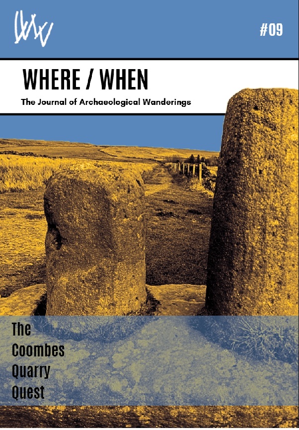
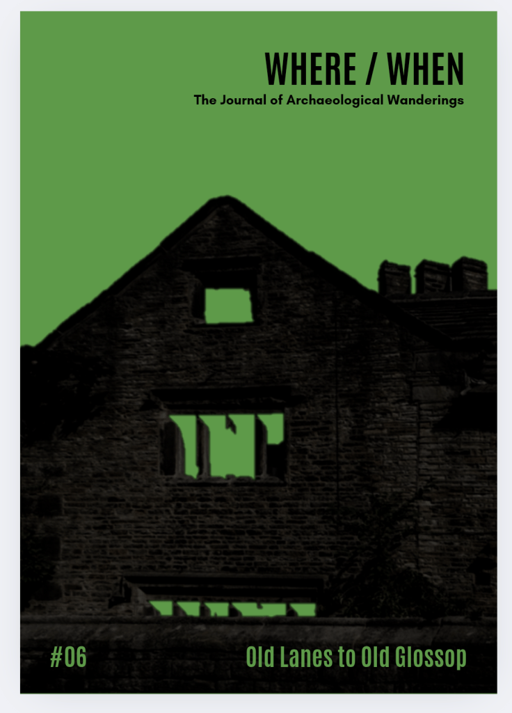
In other news, the new Where/When will be out soon – more info when it happens, but this one is a truly awesome Wander around Mellor – just over yonder! It has medieval field systems and farms, Victorian noise, Iron Age hill fort, medieval crosses, cracking views, a terrifying viaduct, bench marks, a trig point, wonderful gateposts, and it starts and finishes at a pub… what’s not to love? Here’s the cover to tempt you.
Righty ho, I’m off. I have housework to do before I’m allowed a glass of the stuff that cheers – Mrs CG’s rules, which I can’t help feel is unfair… into every life a drop of rain must fall, and all that.
More soon, I promise, but until then, look after yourselves and each other. I remain,
Well, this last month or so has been splendid in terms of weather, what? And indeed much has been done outside – archaeology and Where/When stuff.
Anyway… pottery as promised!
So… Master CG has taken up Windsurfing, which is to be applauded. Like a fish to water you might say, and he’s quite good, apparently (the instructors seem to be very pleased). This means that for a few hours at a weekend, myself and Mrs CG get to relax at the wonderful Glossop Sailing Club (who I cannot recommend highly enough – they are simply amazing), and in the neighbourhood of the wonderful Torside Reservoir in the Longdendale Valley, surrounded by the glacial formed hills; it’s truly a wonderful landscape.
Torside Reservoir is the fourth, and largest, in the Longdendale Chain of reservoirs which flooded this part of the valley in 1864. It is named after Torside Farm, first mentioned in the baptism of Alycia Hadfield in All Saint’s, Glossop, on 16th July 1621. Now whilst this may be the first mention, for two reasons I had a feeling the farm would be older: firstly, Alycia clearly had parents who didn’t just pop into existence in 1621. And secondly, if a place is good for farming in the 17th century, it would have been good in the 13th, 14th, and 15th centuries.
Torside Farm on 1882 OS map, borrowed from the National Library of Scotland website
Interestingly, this first mention in the parish register was actually written as “Thorsett” which, like many others in those pages, is a remarkable fixed record of the local dialect and pronunciation of the 17th century; the clerk asks “where do you live” and the answer from the parent is “Thorsett”, which is then written precisely as said, in clipped northern tones. Even as late as the 19th century, spellings of names and places is not fixed, and confusingly there is often quite a range of spellings for a single farm. Alas, the farm seems to have been demolished by the 1960’s, probably by the water board, and where it stood is now the carpark and public toilets.
Now, knowing this, and whilst young CG was floundering in the somewhat chilly waters, I went for a wander with the hope of finding something interesting and ceramic with which to entertain you wonderful people. Along the edge of the water, and up to the road I walked; I didn’t know what I was looking for as such, more a vague sense that something would be there, this close to an early 17th century farmhouse. And lo! What wonders did appear…
Firstly, I noticed two long walls amidst the general stony foreshore. Made from large boulders that would have, at one time, been plentiful in the fields; they were a convenient source of stone, as well as clearing the fields allowing them to be ploughed effectively.
A 30cm ruler in the foreground as a scale: I am professional… just on a budget! Torside Reservoir, Longdendale: valley, pylons, windsurfing Master CG (and others) in full view… along with a mysterious wall running into the distance.
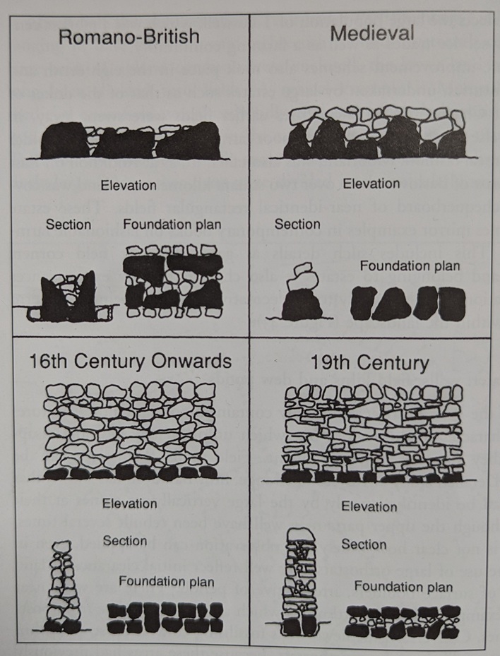
They would originally have stood higher, with this being the foundation course, and the size of the stones, combined with the lack of any map evidence, suggests an early, possibly medieval, date. There is a rough guide to dating walls in this area and hereabouts:
Taken from John Barnatt and Ken Smith’s highly recommended The Peak District: Landscapes Through Time. It’s based on data from Roystone Grange, and whilst it might be over simplistic, it does illustrate how walls changed over time.
It is a rough guide, and isn’t probably applicable everywhere, but it does serve to show differences in how walls were built. I honestly don’t know what these are, but I’m presuming field boundaries for a long lost field system. There are medieval field walls in Tintwistle, and they do look like this, but equally I have seen field clearance walls that date to the Bronze Age that look similar. The following is a rough map and rough measurements – maybe I should go back and really survey the walls properly… anyone fancy helping me?
But enough about the walls, “show us the good stuff… the pottery!” you shout (all except Mr Shouty-Outy, who shouted that he would apparently rather see my bottom…). Well here it is. The pottery that is, not my bottom.
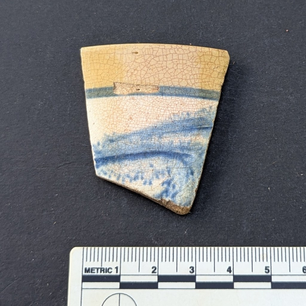
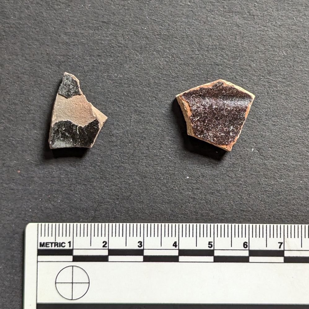
All this was found on the surface, and it tells a very interesting story, but there are some genuinely important bits here. First up, we have a sherd of Manganese Glazed pottery.
Early 18th century in date – it stops being made around 1750 – this stuff is fairly commonly found on sites of this date, and probably come from a jug or mug. I explored this stuff here.
Other bits of Manganese Glazed include these 4 rim sherds from cups and mugs.
Clockwise from top left: an open bowl measuring 16cm, a cup of 10cm, another cup of 10cm, and another measuring 12cm. Lovely stuff.
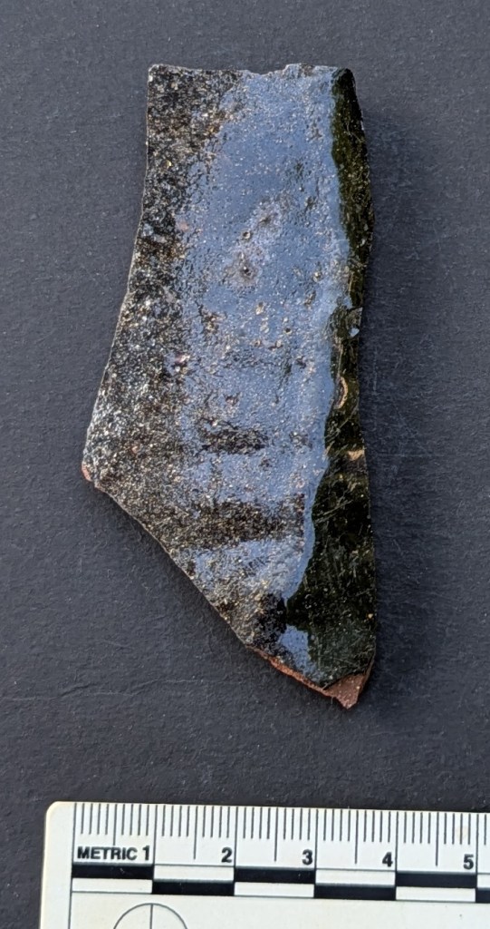
Next up, some slipware.
On the left, a chunky sherd probably from a large jug or similar. On the right we have the rim from a large platter (it has a rim diameter of 30cm); the piecrust edge is hugely characteristic and immediately recognisable (again, I explore it in this article):
The glazed interior didn’t quite make it to the rim, and would have created a striking image: this would have been an impressive vessel when it was whole.
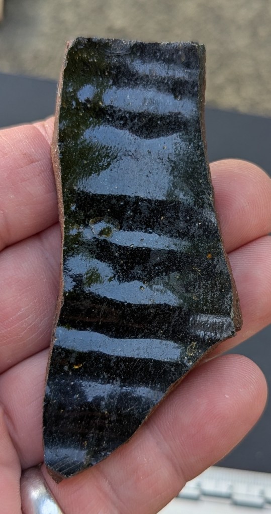
The middle sherd is Staffordshire Slipware, with a Dark on Light decoration. The reddish slip laid over the light background turns much darker when covered in the lead-based glaze. In this case it seems to be giving some form of geometric design – you can see the grooves where the slip was laid, but which has fallen away – the pottery is not particularly hardwearing, and the slip is often found to have delaminated from the body.
Wonderful stuff… you can just make out the linear design in the clay in this awful photo.
This is from the base of the vessel – probably a large platter used for presenting food on the table, and from which all the family would have taken their own share. Turning it over, you can see lots of interesting marks made during the manufacturing process.
When made, the pots are pressed into a mould until they are ‘leather’ hard – that is, hard enough to retain their shape, but not quite fully dry. What we can see on the base are the scars of manufacturing. There are numerous lines scraped into the clay, suggestive of tools used to remove the pot from the mould, or even string. There is also a small ball of clay lodged within the base – this would have been dry and sitting in the mould when the wet clay was placed in it, and when removed it became part of the base. The small holes around it suggest that there were others that didn’t become attached. I love this… it’s almost the secret side of pottery – whilst most people look at the decoration and say “oooh”, let’s instead flip it over and see what else it can tell us.
Next up, we have some Nottingham Stoneware:
I explored this wonderful stuff back in the first instalment of the Rough Guide to Pottery so I won’t discuss it here, but it dates to the 18th century, which is a good date for us. You can see the ‘orange peel’ surface made by using a salt glaze in this sherd:
And on this sherd interior, you can see the horizontal smoothing lines.
I think 2 of the sherds come from jugs or bowls, whilst the base sherd on the left has a diameter of 7cm, so it might have come from a squat round-bellied tankard.
Slightly later than all this is a beautiful sherd of Industrial Slipware:
It’s a lovely fragment of a sugar bowl type thing, with a wide mouth and straight sides. I like how the decoration gently mirrors the environment it was found in – very suggestive of water and sky.
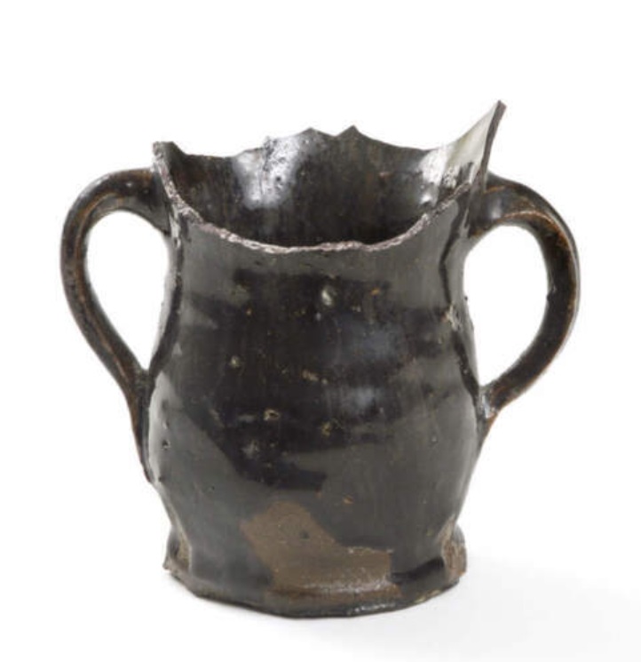
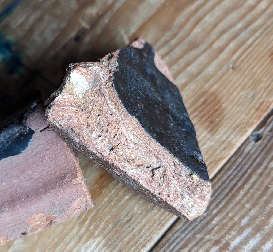
For me, though, the absolute gem of a find was this fragment of a large Cistercian Ware jug.
Dating to the earlier 16th century (1550, perhaps), this is quite special in that it not only pushes back the date of Torside Farm, it is also not something that is commonly encountered. The surface is wonderful in a deep black glaze, and the fabric is textbook purple and hard, with the classic ‘salt and pepper’ inclusions.
The purple colour is on the bottom, the darker grey colour in the fabric is on the inside of the jug, and is caused by the pot being fired in a reduced oxygen environment – essentially, a lack of oxygen during the firing as air couldn’t get into the jug interior properly.
It would have originaly looked something like this:
Image is lovingly stolen from the University of Leicester Archaeological Service’s Facebook page – here
Genuinely, this sherd is, I think, something significant and had me all of a quiver when I found it. I had to have a bracer or two, and thankfully I was soon back to my normal stiff upper lipped-ness.
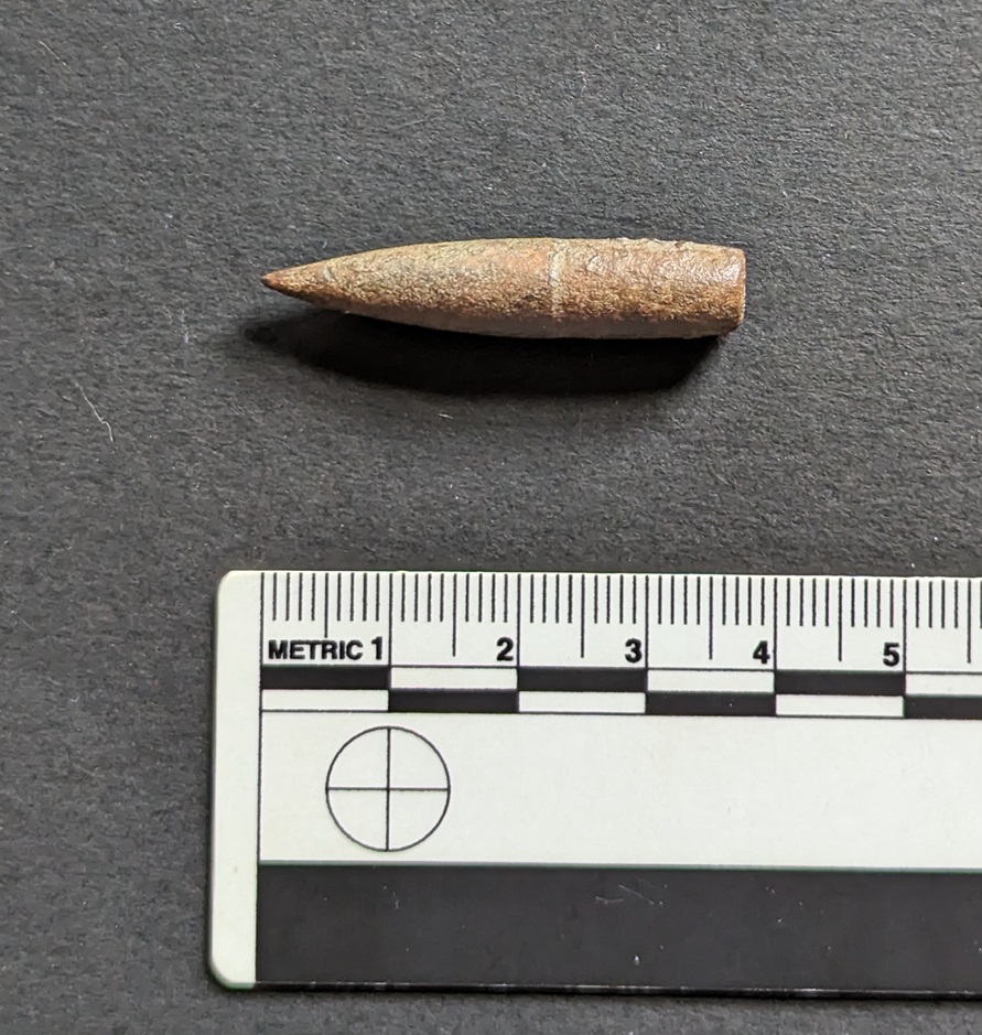
I also found some clay pipe stems here and there amongst the stones; all fairly standard and Victorian with the remarkable exception of this wonderful fragment.
The longer I look at it, the more it looks like it has two eyes, a nose… is singing to me!
It is chunky, being some 10mm thick, but crucially it is a large bore – the hole through the middle is 4mm – which is unusually large, and twice (or more) the width of a Victorian bore (sigh… yes thankyou Mr Shouty-Outy, calling me an ‘unusually large bore‘ says more about you than it does me). All of this means that the stem is early; early 17th century early… probably the same date as the earliest reference to the farm in 1621. It’s wonderful to imagine Alycia’s father sitting and smoking a nervous pipe in front of the fire, listening to the cries of his newborn daughter upstairs, and who knows… this could be the pipe. I love this, genuinely… it makes it real.
I also found a fragment of stone roof tile with the peg hole intact…
A nice shot, that! This must have come from the house or outbuilding, possibly as part of its demolition or perhaps during the course of its natural life.
Slightly older… glacial erratics – bits of stone that are not part of the local geology, which in out case is Millstone Grit and coarse sandstone:
Another awful photo – I will get a proper camera soon, honestly.
I talked a little about glacial erratics here, but essentially they are bits of stone that have been picked up from all points north of here by glaciers moving south during the last ice age (granite, and large bits of quartzite, for example). The movement of these huge structures made of ice, mud, and stone, actually carved out the Longdendale Valley, and when they began to melt roughly 25,000 years ago, they dropped all this odd material. Glacial sand and clay can be found all over the Glossop area (my own house sits on glacial clay), but it is very prevalent in Longdendale. The types of stone, and indeed origin of these, I haven’t gone into; I am not a geologist, but perhaps I should write an article on them?
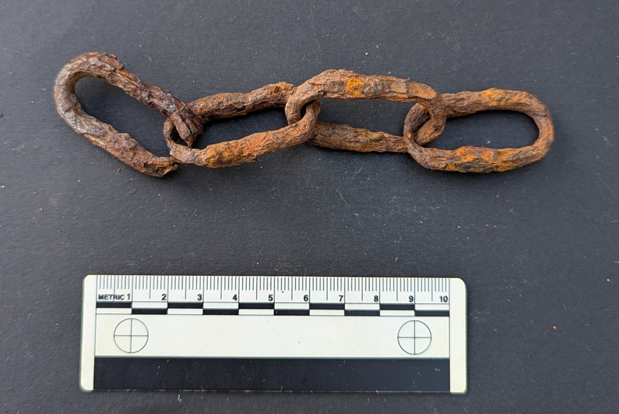
In addition to all that, I found a rather nice segment of hand forged, very worn, iron chain.
I have no idea of the age of it, but it’s certainly at least Victorian… and is very cool!
As I say, the first mention we have of the farmhouse at Torside is 1621, but I am fairly confident that the Cistercian Ware jug is earlier, and perhaps by as much as 150 years – which is very interesting and may point to an earlier incarnation of the farm in the area… which makes sense. The past is indeed all around us, and often at our feet… and it is always well worth having a look.
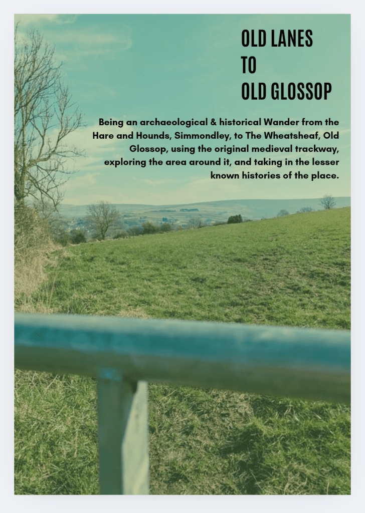
So then, in other news (and also having a look at), the new edition of Where/When has just come from the printers: No.6 – Old Lanes to Old Glossop.
This one is a Wander along the medieval main route between Simmondley and (Old) Glossop, now fossilised into footpaths and odd tracks between buildings. Filled with all manner of archaeological goodness and the usual nerdiness, with a pinch of psychedelia and a heavy hit of psychogeography. Put simply it’s a bloody good walk that goes between The Hare and Hounds and The Wheatsheaf, so what’s not to love?
Contact me here, buy it in the website store, buy it from my Etsy store, the Ko-Fi store, stop me in the street and say “what ho!”, or pop into Dark Peak Books on High Street West, Glossop and grab a copy. It is selling fast… worryingly fast, to be honest!
Right, I think that’s all for the archaeology this month… more soon, obviously. Perhaps more pottery; I’d like to finally wrap up the Rough Guide to Pottery – its unfinished status is frankly bothering my diverse and somewhat spicy mind, and I’d like to be able to wake up not screaming once in a while! Watch this space.
In the meantime, as always – and I do honestly mean it – look after yourselves and each other. This world is not always kind, so let’s – even you Mr Shouty-Outy – try and be kind instead. Until then, I remain, your humble servant.
What ho, you wonderful and slightly strange bunch, you.
A quick one today… I have had almost no spare time to do much more. I have just finished the new edition of Where/When (No.4, The Melandra Meander) – which has taken all my time – and I’ve just started a new job! Busy busy busy! But the Cabinet of Curiosities is a priority, and you, kind and gentle readers, are very important. Plus, if I don’t publish something on the website, angry crowds start to gather outside my house, chanting and making threats – I mean to say, one has to think of the neighbours.
So here we are – a second part to the Datestone post I wrote 3 years ago (three years? Where has the time gone?). I’ll spare the introduction as the original covers that, and just dive in to say that all of the datestones are pre-Victorian (before 1837) – I’d like to do a survey of the datestones of the Victorian and later periods, but there are so many that it would be a big task. If anyone fancies giving me a hand, though, give me a shout.
So then, first up is a correction. Hurstnook Farm has a stone that I drew through a pair of binoculars, as I couldn’t get close enough to photograph it. Well, they’ve been doing some work there recently, and me being me, I wandered over and asked if I could take a snap, and Lo! The result is below.
F.S.M.W, and the date of 1772. Lovely detailing, too – this is an expensive looking stone.
And a wonderful datestone it is, too. Different from my interpretation of it, and I still have no idea of the names; W is probably the family name – possibly a Wagstaff? I’m sure looking through some deeds would produce a name, though. Any thoughts, anyone? There is another datestone on the extension next door that reads 2010, but is designed to copy the original one, to fit in with the building.
Next up is #13 Padfield Main Road, Hadfield.
J.H.A 1826. Simple and effective.
A simple datestone, but I honestly love this one. And the colouring is effective.
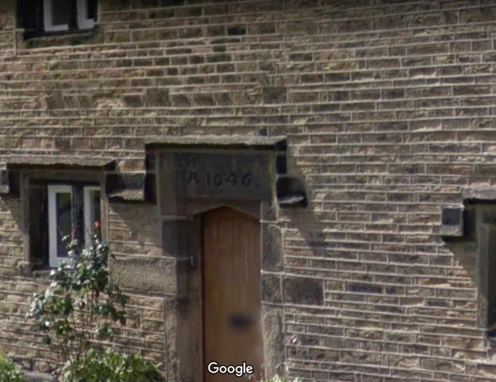
Next up, Hadfield Hall – a truly wonderful building. I could study this place for hours, and often find myself marvelling at the structure, and all the phases of construction. Now is not the time for a detailed look at the hall – a future post, perhaps. Still, it has a cracking datestone above the door.
I(J).H. T.A. 1646
Lovely stuff. Hadfield family? I’d love to know more – any thoughts?
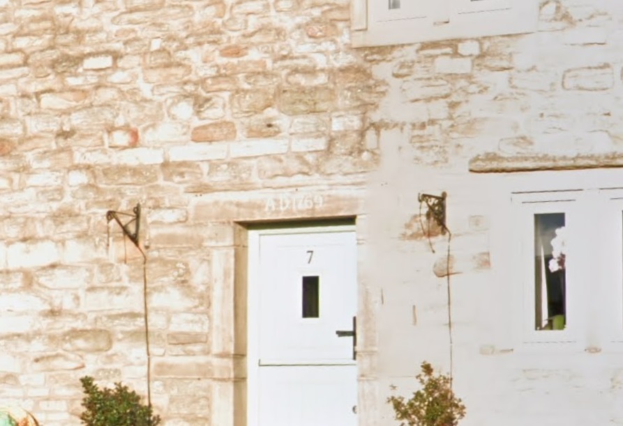
Just opposite Hadfield Hall is 7 Old Hall Square:
AD 1769
A simple date, rather than a chance at immortality.
Next we have 2 from Shaw, the farmstead that is first mentioned in 1285. It forms one of a number of such places dotted around Mouselow, and is a fascinating place. I suspect there is a lot of history here, and would love to have a poke around some of the properties there. If anyone reading this in Shaw fancies letting a slightly odd bloke have a rummage, so to speak, shout out!
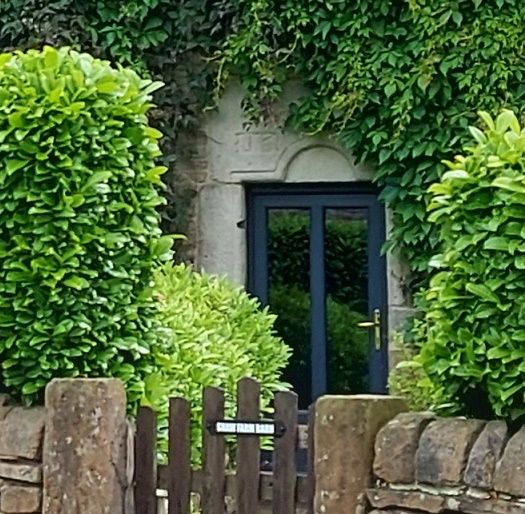
First is Shaw Farm Barn
G.B. (D) M.B. (B), 1694
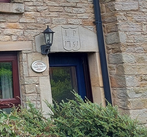
Not a great photo, but the inscription is correct. It’s on a whacking great lintel, which is very suggestive of an earlier, perhaps Tudor, door lintel that’s been re-used. Makes you think… And then, next door, is Shaw Farm:
I (or more properly J).P. 1751, in a rather fetching shield motif.
The names here again escape me – J.P. (the ‘J’ is rendered as an ‘I’ as was the custom).
Next up, the Hare and Hounds, Simmondley.
G.B.P. 1784
I actually know the meaning of those initials – George and Peggy Booth. Also in Simmondley, we have Dingle Cottage which sits on the old trackway from the farms over Whitley Nab way.
M.L.R. 1706
A truly fascinating building, and again, one in which I wish I could have a poke around!
Next is Hall Fold Farm, Old Glossop.
J.S.J.G. 1806
The datestone was apparently found buried whilst the farmhouse was being renovated. The image is not mine, but was taken from the always interesting (and essential if you like Glossop’s history) Old Glossop History Trail website. I want to take one of my own, but oddly people view Herberts taking photographs of their houses with a bit of suspicion!
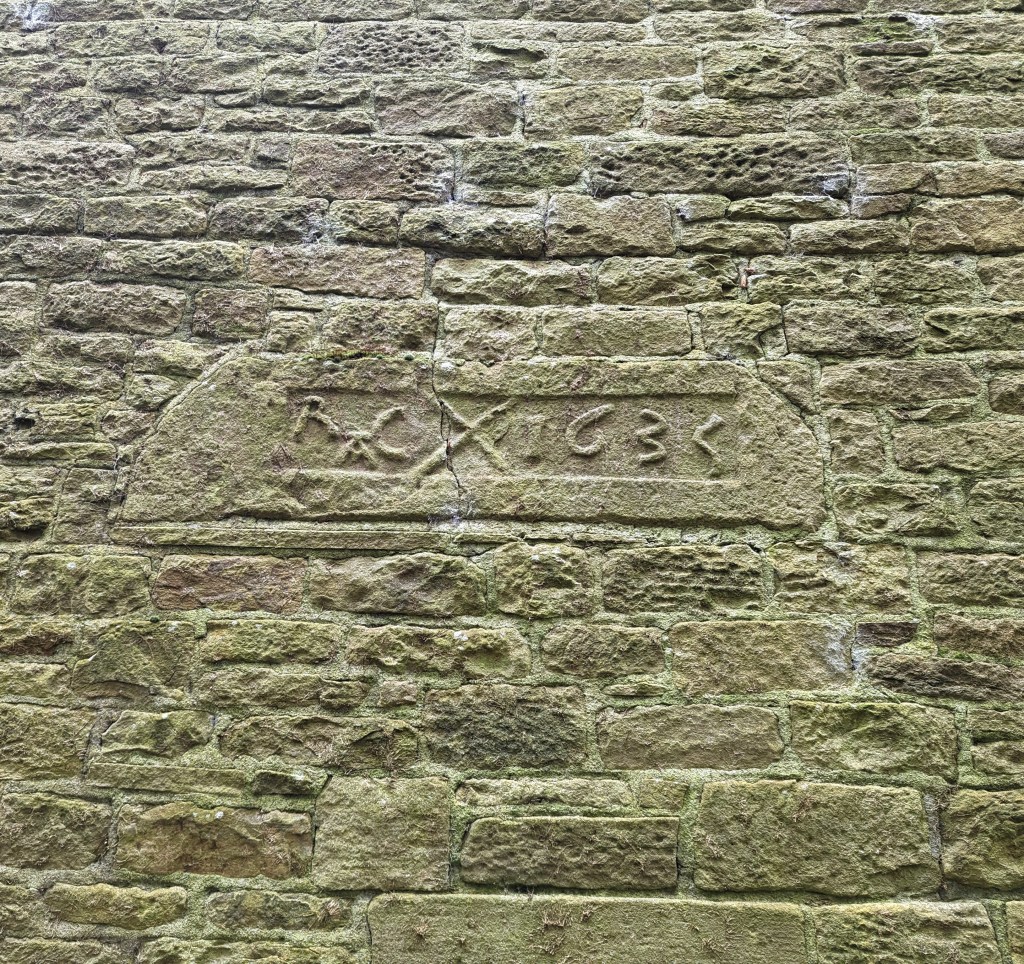
Another Old Glossop datestone is unusual – this is built into the side of Hillside Cottage, down by Laneside Farm:
R.A.C. 1635, with a decorative saltire.
A few things to say about this one. Firstly, it is the second oldest datestone in the Glossop area, pushing Hob Hill Cottage in Whitfield into third place. Secondly, the decorative saltire might also function as a protective motif, as the shape is a fairly commonly found apotropaic mark. But the important thing is that it is not in its original position, above a doorway, and in fact the house it is built into is late Georgian or early Victorian. I can only assume that it replaced an earlier building, and rather than throw the lintel away, the builders thought they might as well build it into the fabric of the house as decoration. As for the initials – I have no idea.
Next up, and finally: Flax Cottage, Wesley Street, Old Glossop.
S.W.E. 1783, and a little flower motif.
The flower motif in Flax Cottage is very similar to that at Hurstnook Farm – possibly the same stonemason carved it 11 years later?
Ok, so that’s it for datestones. There are others in the area – a few in Charlesworth, Herod Farm, Hobroyd Farm, etc. – but I don’t have photographs yet. If anyone does, or if anyone knows of any others that I don’t know about, then please give me a shout.
In other news. As I say, Where/When No.4 is about to be printed – I sent it yesterday, so it will be here next week, fingers crossed. I’m super excited about this one, and it might be the best yet. I’ll post more soon, and with other news too. But until then, look after yourselves, and each other, and I remain.
I know, I know! Another instalment of the seemingly never-ending Rough Guide… it really is the gift that keeps on giving, isn’t it! I can see and hear the hubbub from here. The yelps of excitement, the whoops of joy, the screams of happiness… lots of these. And the exuberant dancing in the street. It even looks like people are running away from me… what fun! And oh look, that man over there has started drinking what looks like cheap vodka from a bottle, and is shaking his fist at me in a cheerful expression of his enthusiasm. Steady on, there’s a good chap…
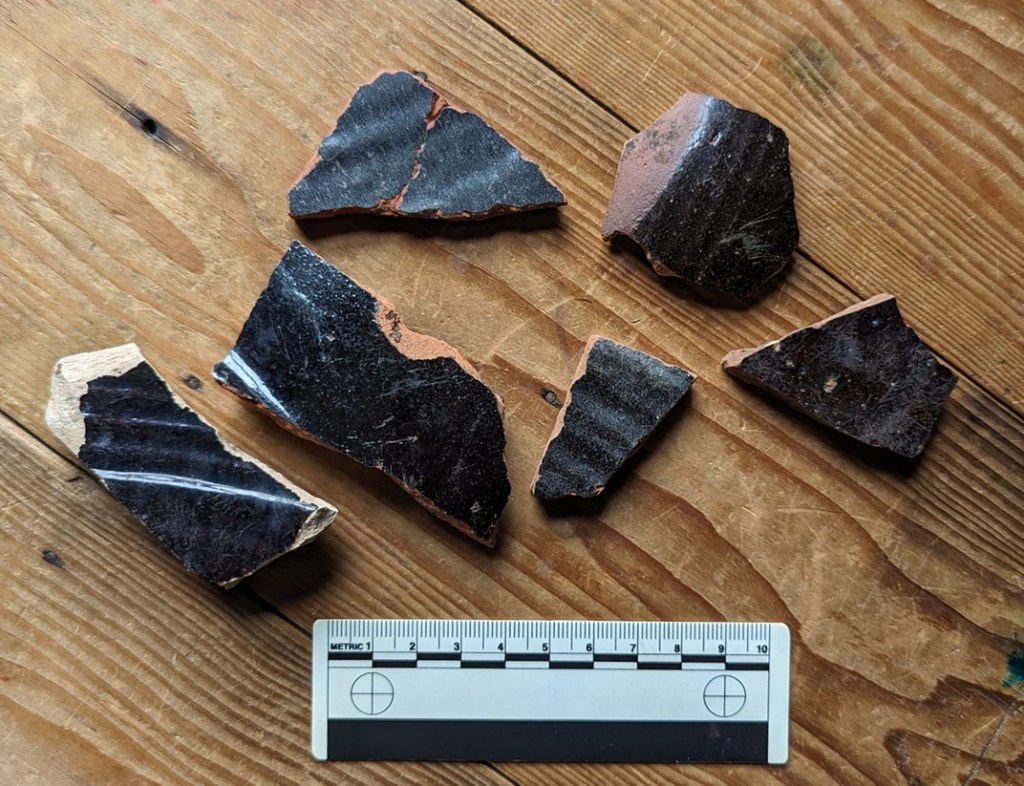
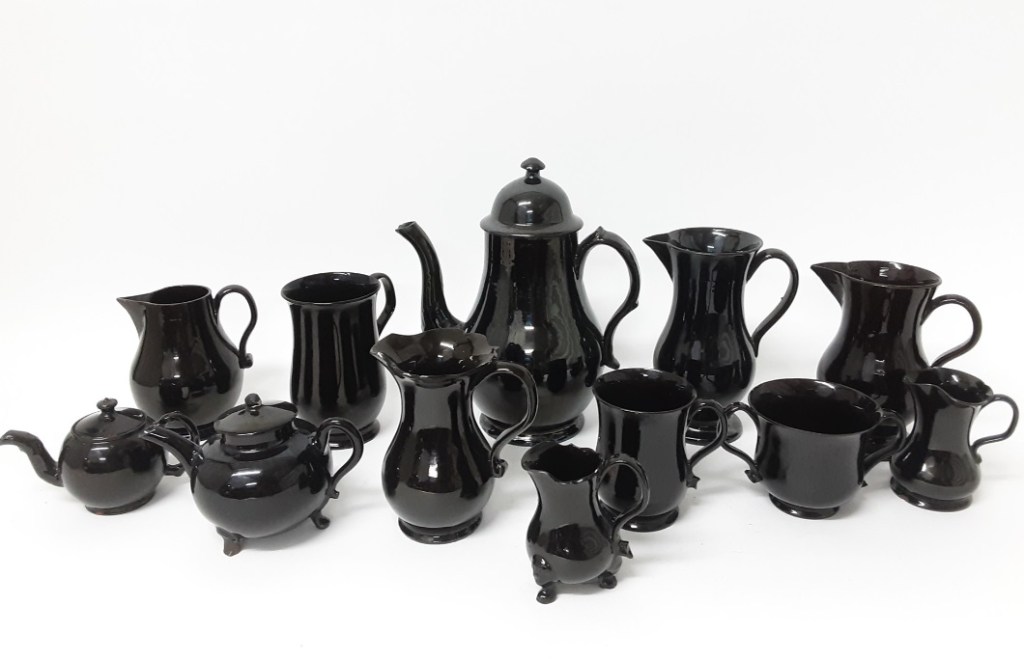
So then, today’s offering is simply black pottery.
At most places you encounter pottery, you will find sherds with a black glaze on them. Of varying quality, and of various sizes and forms, there is always a background noise of them, as a wander through the archives of the site will show. It’s less common than the Blue and White stuff, but you will find it. Most often as a big sherd of a thick walled vessel – a chunky rim if you are lucky – but more often featureless body sherds that feel like they ought to be able to tell you something… but don’t. Mostly these are difficult to date; one black sherd looks very like another, and without having the whole vessel to look at, it can be futile to try – even I just mentally lump most of them together under the banner ‘Victorian’. And largely I’d be correct (as if you ever doubted me!). But… actually there are subtle differences that can give a little more information and provide a rough date.
The problem is that Black glazed pottery is just that. Pottery… with a glazed black surface. So you can see how assigning a date to it might be a tad difficult, and whilst there are some broad observations to be made, the finer points of interest are missed. It has taken me this long to fully wrap my head around it, and I think I have it straight, though even now it’s fuzzy in places. I don’t like ‘fuzzy’. I like things to be simple and logical and straightforward, with neat edges and exact dates. Today’s offering has none of that and is full of fuzzy, which frankly makes me feel a little uncomfortable (does anyone else feel that these little interludes are starting to sound like a therapy session? What do you mean “we know you’re a raving lunatic, get to the pottery”… honestly). No, they are a problem, and quite rightly most people shy away from them; I mean to say, these bally Herberts frighten me… I can only imagine what your normal non-sherd-nerd would make of them. No… by and large it’s safer to just leave them. Unless, of course, some lunatic tries to impose some form of order on it, and takes a trip to the dark side in order to investigate Black Glazed Pottery.
Well… cometh the hour, and cometh the lunatic.
The following is a rough outline of what, where, and when; it isn’t final, it can’t be applied as a law, and certainly not everywhere, and there are always exceptions, and always overlaps. Indeed, we can only speak here of a pottery making ‘tradition’ rather than clean-cut specific ware types, and people have been making pottery in a black-glazed tradition for over 500 years. But it will allow you to look at your black sherd and say “oooh, that’s probably a…”, which is sort of the point of this guide (no, Mr Shouty-Outy, despite what you think, the point of this site is not to attempt to be “the dullest thing on the internet“, thank you very much).
So, we start today somewhere in the 15th century, which is nice!
CISTERCIAN WARE DATE: 1475-1600-ish DESCRIPTION: Fine, hard-fired, purple or reddish purple fabric, with a very dark brown to black glazed surface interior and exterior. SHAPES: Mugs, Cups, Tygs, Small Jugs.
This is the first black glazed pottery type, and overtakes Tudor Green Ware as the pottery type found on early Post-Medieval sites up and down the country. It’s origins are unclear – as a tradition it is unlike anything that went before it, and was the technological and design cutting edge. It was originally thought of as being made in Cistercian monasteries in the north – hence the name – it is now known to have been made all over, most famously in Wrenthorpe (West Yorkshire) and Ticknall (Derbyshire).
Sherds of the whole…Image stolen from St Albans Museum (and a damn fine museum and website it is indeed)
Characterised by a very thick all over (interior and exterior) iron rich glaze which produces a very dark brown or black surface when fired.
The glaze is shiny, but has a dullness to it – also very characteristic – and is often fairly poor quality, with pitting and an orange-peel surface, and is often sloppily applied, leading to melted blobs on bases, etc. – it’s still very much in the medieval way of doing things.
The bubbled glaze, melted in the heat of the kiln. Also on the base, you can make out the circular marks made when the Tyg was removed from the still spinning wheel with string. The straight lines might have been where the potter was testing how moist the clay was before putting it in the kiln, and it is something I have seen on other vessels of this period.
Very rarely, there is a pale cream decoration applied in slip, often in blobs or rough images of unicorns or other designs.
The fabric is also very characteristic. Very hard fired (almost vitrified), it is a purple, greyish-purple, or reddish/brownish purple colour. Looking closely at it, you can see voids formed by gases during firing, and very infrequent quartzite ‘sandy’ bits.
You can also see the thick glaze in the section.
Shapes are mostly drinking vessels – mugs, cups, and tygs (multi handled cups) – with a sprinkling of small jugs and bowls; the emphasis, though, is very much on the stuff that cheers! Handles are often small and delicate, and normally flat.
Taken from Lloyd Laing’s useful book Pottery in Britain 4000BC to AD1900 – very good on early stuff, not great on Post-Medieval… which is why I started the Rough Guide.
I am lucky enough to own a copy of a Tyg by potter John Hudson, an amazing craftsman who used traditional techniques to faithfully recreate medieval and post-medieval vessels:
Lovely stuff – its 3 handles make it a joy to hold. I have, on occasion, carefully sipped a snifter from its curiously shaped body.
The making of this ware type – with this specific fabric type and in these shapes – seems to have died off by the late 1500’s, but the black-glazed tradition continues.
BLACKWARE (aka Midlands Black Ware, Black Glazed, Ticknall Ware, etc. ) DATE: 1550-ish-1800-ish DESCRIPTION: Black shiny glaze over a red or reddish brown fabric. SHAPES: Mugs, Jugs, Tygs, Bowls, Dishes.
This stuff continues the tradition of making pottery with a lustrous black glaze, but without the hard purple fabric. Instead, reddish, reddish-orange, or occasionally buff coloured fabrics are found, and overall it is fired to a lower temperature, making it less hard and more, well, coarseware-y. Often with a small number of quartzite – sandy – inclusions, but normally of a consistent colour throughout.
Fabrics! Multiple colours, and more inclusions than the Cistercian Ware.
The surface is normally much shinier than Cistercian Ware, but can also be found as a metallic looking surface, the result of adding lead in the form of Galena. Often there is an under-glaze slip that provides a red surface which, when covered in the glaze and fired, creates the black surface. This is particularly true in the case of the buff or whitish coloured fabrics such as that in the photo above.
With the light in the right place, you can really see the metallic sheen.
It has been suggested that this was a desired effect; in the poor candlelight of the 17th and 18th centuries it might look like it was made from more expensive pewter. This is a Skeuomorph, an object made from one type of material made to look like it is made from a different material; we’ve encountered it before in the Manganese Mottled Ware pottery. I’ve said it before, but don’t say we don’t learn you nuffink on this website!
Shapes include many of the same type you find with Cistercian Ware – mugs, tygs, jugs, etc. – although slightly more evolved – for example the mugs and tygs are noticeably taller. However, we now see larger bowls and jugs, too. Blackware becomes the utilitarian ware type, and thus it takes on many forms and uses.
To be honest, there is a deal of overlap between Cistercian Ware and Blackware, especially at the beginning, and it is not an exact science. Moreover, it is a good example of problems within post-medieval pottery studies: many different potters are making this stuff, in many different locations all over Britain – the black glaze was very popular, and so there was a ready market. But, 100’s of years later we have archaeologists digging this stuff up everywhere, and mudlarks/tiplarks/fieldlarks finding it all over. But there is no consensus as to what this stuff should be called! And why would there be? It is made everywhere, is found everywhere, and comes in so many different forms. In fact, I only call it Blackware because the last article I read called it that, and I like the name – it is helpfully vague in that it doesn’t rely on a geographical place (Ticknall Ware, for example), or a specific vessel shape (Pancheon Ware), to define it, but it is specific enough to describe what it is. See… fuzzy edges! I’m feeling very uncomfortable… I need a bracer!
The vast majority of the stuff you might find will be in the later part of the date bracket given above – late 17th/early 18th century. Indeed, by about 1720 the Blackware tradition starts to decline, although it probably continues until the end of the 18th century. Whiteware has become the pottery type – white is the new black, and all that – and we see that start of the quest for the perfect white surface that I have talked about before. To be fair, it was dying from the mid 1600’s onwards, with the introduction of the classic post-medieval pottery types – the Manganese Glazed and Slipwares.
Well, I say dying. Actually, and more specifically, the thin-walled vessel Blackware pottery tradition tails off, but it continues to be used on Pancheons.
PANCHEON WARE (Coarse Earthernwares) DATE: 1700 ish-1900 ish… emphasis on the ‘ish’! DESCRIPTION: Thick-walled (1-2cm), often reddish/orange coloured fabric, commonly with a black internal glaze, and with a chunky rim. SHAPES: Well, er… Pancheons, but also other large utilitarian vessels: large pots, colanders, chamber pots, etc.
A lovely word, for a great category of pottery – the mighty Pancheon – also described as mixing bowls, cream separators, or dairy bowls. Their purpose is multiple, as their name suggests, but it is their large size that is really impressive, as is the skill, detail, and indeed general lack of care with which they were made and decorated. Into this category we might also add large bowls, large dishes, chamber pots, and colanders. But the commonly encountered type, Pancheons, are generally steep sided open bowl shapes, with a height of up to 30cm, and a rim diameter of up to 60cm, or more. They are big pots, and consequently the sherds, are usually thick walled, ranging in width between 1 and 2cm, and are instantly recognisable.
A complete Pancheon – the word may have been a corruption of Puncheon, meaning a large container of liquid (and possibly the origin of the word punch, meaning a mixed drink).
Fabric is normally reddish or reddish brown.
Commonly, though, the fabric is poorly mixed with another cream or buff coloured clay, giving it a distinctly marbled effect.
Very clear marbling in this sherd.
Why this was done is unclear. If it was just a few examples of this happening, we might suggest that the potter was using up some spare clay he had lying around, but it is too commonly found. It can’t have been a decorative reason as no-one would see the fabric unless the pot was broken. I wonder if it was a practical concern, and that the buff clay had different thermal properties, perhaps allowing the vessel to shrink uniformly when drying or during firing? This might explain why it was poorly mixed into the fabric. But honestly… answers on a sherd to the usual address. My feeling, though I can’t be certain, is that this was more commonly found in earlier vessels, and that these mixed clays stopped being used in the 19th century.
Within the fabric are often found small inclusions – sometimes quartzite (sand), sometimes other small stones, and occasionally grog – crushed fragments of pottery. These too have the effect of improving shrinkage during, and strength after, firing.
Vessel rims are very distinctive – thick and chunky, and often square-ish in section, although other forms of rim – particularly those from shallow dishes – are flatter. Again I suspect, but can’t prove (yet) that these are early vessel types, and that by the 19th century the Pancheon takes on a single uniform shape which is made by potters all over the country.
Some Pancheons have handles, and often these are scooped lug type handles.
I love this – you can see thumb marks where it was pressed onto the body whilst wet. But also, you can see scuff marks above, where it was fixed properly and the potter accidentaly left an impression. Rough, and not over produced pottery like this, is so much more human.
Perhaps most distinctive is the black glazed surface. Because these vessels were normally only glazed on the interior, you will only find it on one side. As with the Blackware above, the dark colour was achieved by roughly painting a red slip on the interior and the rim, over which was applied a thick iron-rich glaze which, when fired, becomes the very dark brown or black we see. Sometimes this red slip was applied to the whole vessel, but even then any glaze or slip on the rim or exterior is the result of spillage.
Here you can clearly see the red slip over the orange fabric, and where the glaze has splashed has become black. Also, lovely lovely wiping marks, and is that a fingerprint? A person made those… 200 years ago! *shudder* This is why I do what I do!
That said, sometimes this spillage was a deliberate decorative feature, with the large exaggerated thick drips over the rim and down the outside giving it a certain devil-may-care look.
Lovely stuff!
This devil-may-care look also extends to the interior and exterior surface treatment of the vessels, where they also make use of ‘manufacturing’ marks as a form of decoration, thus you can see deep grooves and ridges on the interior and exterior where the clay has been pulled up on the wheel, and roughly made smoothing marks on the exterior.
Groovy! What? It made me smile…
Indeed, overall they seem to be very roughly made, with little attention to ‘perfection’ at a time when pottery was fast becoming quite literally an art form. I suspect that this is in part due to speed being the essence in making them, combined with the fact that they are entirely practical with very little attention paid to decoration. Even the fact that they are glazed on the interior only is suggestive of their practical nature – it’s quicker to glaze only one side, and it is cheaper, but it is also not necessary to glaze the exterior as only the interior needs to be waterproof. However, I also think there was a decorative element to the roughness – the exaggerated drips, the course smoothing, the noticeable finger and thumb marks in the wet clay and slip. I like this, it adds character and a human element.
Deliberate grooves on the interior and exterior of these vessels.
Now, whilst most sherds you will encounter are Black glazed, within the broad category of Pancheon Ware are sub-types, with different coloured exteriors – namely Brown, Yellow, and Pale Yellow/Cream.
A massive chunky rim sherd… from my back garden!
Actually, the colours depend on the amount of iron in the glaze and the colour of the surface underneath, but it is all the same process. It works like this: the more iron you add to a glaze, and the darker the surface under the glaze, the darker colour the pot will fire. And conversely, the less iron you add to the glaze, and the lighter the surface under the glaze, the lighter the finished pot will fire. So the Yellow glazed sherds often have a white slip and a glaze with little iron in it, and the Cream, too, but with a glaze that has even less iron added to it.
You can clearly make out the white under-glaze slip covering the naturally red clay where the glaze has peeled away. Ignore the writing, that’s a code I use in my reference collection (which is kept separate from the main ‘Pile o’ Pottery’) to tell me where it came from: BGW = Back Garden Wall. Here we can see where the glaze has run over the white slip and onto the red fabric, producing the brown stripe. Now imagine if the fabric was a darker red, or had a red slip… it would produce a black glazed surface.
Brown has a darker coloured red fabric or a red slip, and an iron rich glaze, but not as iron rich as the Black glazed surfaces.
The truly wonderful Bingham Heritage Trails Association, who have done an amazing amount of work on post-medieval pottery (a very much recommended website full of pottery), have given them different names, and put them in a tentative chronological order, depending on fabric types and surface colour. This might work, but I’m not 100% convinced, and I think the differences maybe have more to do with desired colour, geographical origin of the clay, and our old friend fashion, than the date it was made. Essentially, any colour/surface treatment could have been made at any stage between 1650 – 1900… ish. I am always happy to be wrong, though – its the story of the pottery that matters.
The fact that Pancheon fragments crop up everywhere is both testament to their popularity – at one stage everyone seems to have had one – but also their large size; there’s simply more of it, so when they break up, they produce many more sherds than, for example, a smaller plate would.
Overall, it seems that Pancheons – and indeed all of these large domestic vessels – stop being made, or at least stop being popular, at around 1900 (although I’m sure many would still be in use from then on). Why is unclear, but it may simply be that the large clunky vessels were impractical in most kitchens, particularly in the cramped interior of terraced houses in the cities, and so they fell out of favour.
Our final black glazed pottery type is…
JACKFIELD WARE (aka Shining Black) DATE: 1750 – 1820-ish DESCRIPTION: Very shiny black surface on a red earthernware fabric. Often has handpainted white decoration. SHAPES: Very tea/coffee focused, so teapots, coffee pots, sugar bowl, cups, jugs, mugs, creamers, etc.
Not common at all (I only have one sherd!), Jackfield Ware is a refined earthernware that was popular for a short period in the late 18th century, and was focused on the consumption of tea and coffee, incredibly fashionable at that point in time. It reproduced all the essential elements of the black glazed tradition, but did so to an almost perfect finish. It is named after Jackfield in Shropshire, where it is known to be made, but the majority seems to have been made in Staffordshire. I have to say, this stuff is almost impossible to identify as a single sherd – it looks very like all the others, perhaps just a bit finer. If it wasn’t for the painted decoration on this example, I wouldn’t know I had any at all!
Fabric is red or a reddish brown, hard fired, with almost no inclusions – it is refined, and dense, and the vessels are thin walled.
The surface treatment is a uniform black glazed interior and exterior, with the glaze being particularly shiny – almost metallic – probably due to a high lead content. Honestly, you can see your reflection in this stuff. There is often sprigged decoration (a separately moulded clay three dimensional design stuck on the outside – often, in this case, floral designs – flowers, grapes, etc.), but commonly there are hand painted designs. These images were painted after the vessel was fired – over-glaze decoration – as contemporary under-glaze paint wouldn’t survive the firing process. As a consequence they often rubbed off, and exist as ghost-like images, especially in the kind of sherds that we find.
A flower design – I really like this. You can also see how it would wear away easily.
In terms of manufacturing, you can see the grooves where the potter pulled the clay up, but only on the interior wall where it wouldn’t be seen – this is fine pottery after all – whilst the exterior is super smooth, and is usually turned on a lathe to produce a perfect finish.
Shapes, as I say, are dominated by tea and coffee consumption, so commonly there are teapots, coffee pots, and cups.
The cups are more like those we would recognise today in that they have only one handle, rather than the multiple handles of the tyg – a design development. This is the start of modern pottery… raise a toast with your next cup of tea!
And to end with, a broad description of Midlands Purple Ware, a slightly coarser version of the fabric that Cistercian Ware is made from.
MIDLANDS PURPLE WARE DATE: 1400-1700 ish DESCRIPTION: Hard fired coarsish pottery, purple-brown/grey in colour. Coarse surface, normally slipped with wiping marks. Occasional internal dark glaze. SHAPES: Large open vessels, bowls, urns with spigot hole, salt pans, butter pots, rarer in small vessels, cups, mugs, etc.
Not commonly encountered to be fair (I only have a single, if large, sherd), but it is occasionally found in small quantities on early sites, and is part of a story. Midlands Purple straddles the period between the medieval and periods wonderfully, and takes elements of both.
My only sherd of Midland Purple Ware. Mind you, it’s a biggun!
Made in the same potteries and kilns as Cistercian Ware, and indeed the larger Midland Purple vessels were sometimes used as Saggars (a protective ‘box’ within a kiln) for the smaller and more delicate Cistercian Ware vessels. Thus we can be sure that the two ware types were contemporary, and Cistercian Ware seems to share the fabric type – that is, both ware types are made using the same clay, and fired at the same temperature, to produce a very similar type of fabric.
Purple, reddish purple, or greyish purple in colour, the fabric is hard fired, almost vitrified, with numerous voids, and has numerous quartzite inclusions, often with a black and white “salt and pepper” like colouring.
The surface is purplish, greyish purple or a browny purple, and is usually slipped, or simply smoothed, and smoothing marks are normally visible. The inclusions also poke though this slip, giving the surface a coarse feel. Rarely it is glazed on the interior, and these are normally found on butter pots, used to export butter into the big cities, notably London. A common shape is that of a jar with a reinforced bung hole just above the base, and these are often associated with domestic beer making, with the holes taking a spigot. Shapes include jars, butter pots, storage jars, jugs, pipkins, bowls, mugs… in fact a huge range of vessels, but the large jars and butter pots are the most common.
Midland Purple Ware shapes.
Traditionally, MPW is though of as dying out by the late 17th century, when it’s role as the hard-wearing utilitarian pottery type was probably overtaken by the aesthetically more pleasing Brown Stonewares.
So there we have it, Part 10. I’m pretty sure people who have spent long years studying one type of black glaze from a single pottery workshop are currently forming angry mobs, complete with lit torches and pitchforks, to seek me out, but I hope it helps.
The bad (good?) news is there’s only two more parts to the Rough Guide… Finewares and “Things That Might Be Pottery… But Aren’t”. The good (bad?) news is that I’m going to try and edit this guide into a Where/When Special booklet or zine, so that you can take it with you when you go Wandering. I know, I know… you can’t wait.
More very soon, as I have some big announcements! *Cough Wanders-a-plenty *Cough… and more.
Until then, please look after yourselves, and each other – just a quick check in with the neighbours, or even the person serving you in the shop, can make all the difference.
Right… got to be quick! So much to do, so little time. Never mind the formalities… we’ll take them as read.
Family C-G went for a stroll the other day, around Shire Hill and Shelf Brook there. This gave me the opportunity for a little poke about… and O! What things I found!
I was poking about on the track that runs from the top of Shire Hill to the footbridge – here:
It’s an old track, coming from Pyegrove with its datestones of 1747 (although first recorded in 1631) where the track splits; left to (Old) Glossop, right – ours – up Shire Hill and down, linking it with Shepley Street/Doctor’s Gate. Interestingly, although it now curves to the right at the bottom by the brook, it’s obvious it originally went straight ahead and over the brook via a ford. The field on the left there preserves the original line of the track.
I know I bang on about these tracks a lot, but they really were the arteries of life in the medieval and post-medieval period, in fact right up until the late 1700’s and early 1800’s when our present road system was planned and laid out. These have a more organic feel about them; they grew out of necessity – rather than as drawn on a map and blasted into the landscape – and as a consequence they are often more direct, but also strangely quirky. And as everyone who moved through the landscape would have used these tracks, they can often be good places to poke around, to see what we can find. And lo! Here’s what I found.
Firstly, a selection of clay pipe stems:
Nothing too interesting here, to be honest. All have fairly narrow bores, and are thus probably all Victorian, and no maker’s marks. I have said before that these are essentially the Victorian equivalent of a cigarette butt – smoked a few times, then thrown away. Or perhaps dropped – the pipes are fragile, so they wouldn’t survive a fall. Always fun to find, though.
Next up fragments of what I think in the same pot.
Despite all being different thicknesses, they all seem to be from the same large stoneware open bowl or something, in what looks like a Bristol Glaze. The different thickness can be explained by where the sherd came from on the pot; vessel walls tend to get thicker as they move towards the base, and thinner the higher up they are towards the rim.
Next up, some more stoneware:
The sherd on the left is the top to a ‘blob top’ stoneware ginger beer bottle, something like this one:
Stolen, as always, without shame, this time from ebay. Buy the bottle here for $44 Australian Dollars.
At the right, there are a series of sherds from the same flat bottomed jug or jar or similar in a brown salt-glazed stoneware, possibly a late example of Nottinghamshire Stoneware, but difficult to tell.
The larger sherd in the middle is the shoulder of a bottle, perhaps similar to the ‘blob top’. On the inside, though, you can see the wiping marks created when the bottle was made by hand.
This is the human connection to the mass production of the Victorian period, the marks made by a person going about their working day.
Next up, we bounce into the 17th and early 18th century.
On the left, an open vessel in Slip Trailed Ware – probably a large, thin-walled bowl of some sort. On the right, is a Manganese Glazed cup or small bowl, with a carination in the body. ‘Carination’ is one of those terms archaeologists use that literally no one else uses, but it simply means a kink in the shape of the vessel that creates an angle, often at the shoulder. Both of these types are fully discussed in this article here.
Next, we have a large sherd of Manganese Glazed pottery, almost certainly from the lowest part of a large open bowl.
Again from the 17th/early 18th century, it is rather wonderful. Glazed on the interior only, the exterior is slipped:
You can see the red slip on the surface of the swirled cream/pink fabric – very typical of the period. You can also make out the wiping marks made during manufacture. This was a large bowl, and unusual.
Next up, we have this little lot, again of 17th or early 18th century date:
Left is another sherd of Manganese Glazed Ware. Centre is a sherd of Staffordshire Slipware, also covered in the above article. You can clearly make out the white under-glaze slip that gives it its characteristic yellow colour. At the right, however, is a sherd of Midlands Purple Ware… something that we’ve not encountered before. I have a ‘Rough Guide to Pottery’ post about this stuff almost written, so I’m not going to dwell on it here, but in short it is very hard pottery (fired at a high temperature) and slipped in a purple or reddish colour, and the surface/fabric has black and white – salt ‘n’ pepper – inclusions. It’s very distinctive… once you see/feel it, you’ll never forget it. It is an interesting type of pottery – it starts in the 15th century and continues until the early 18th century, and is associated with beer making, as well as butter and cream transportation.
Rather unusually, I also found this – a .303 rifle bullet, and probably fired from a Lee Enfield rifle.
I’m not sure how it ended up there – it’s a military round, but they were used on the rifle range just up the way ( I blogged about that here) – so perhaps it was an overshoot… worrying, given that it was on the path!
And finally, whilst Master CG was snorkelling in the brook (I wish I was kidding), I went poking about looking for glacial erratics, and found this little beauty of non-local geology.
I think its gneiss, an igneous stone, but I am an archaeologist, not a geologist (or indeed an architect. Nor a palaeontologist, so no, I don’t know anything about fossils, dinosaurs. Or ancient aliens. It’s amazing what people think you are when you say you are an archaeologist). Here is a handy little guide to the rocks of Britain produced by the Natural History Museum. Whatever it is, it isn’t the Millstone Grit and local Rough Rock that makes up the geology of the area, so it’s a visitor, and probably one that hitch-hiked in a glacier from the north, as we discussed here.
Right, that’s all for now. Apologies for the lateness of this post, I have been super busy – with many talks and walks, and many more in the pipeline. I’ll advertise some here, so that I can bore as many of you as possible! I have also just sent off Where/When 3 to the printers, so by the time you read this it should be available to buy from usual sources. More about that in a few days, but for now, look after yourselves and each other, and I remain.