Apologies for the lack of posts recently, but things are a bit odd at the moment. Six weeks ago we were concerned about Covid19, but were still joking about it, and how it will amount to a fuss over nothing. Now, here I am in front of my computer in ‘lockdown’ for the foreseeable future, and a very real and sobering death count is still rising. It really is a strange time, and the country is a strange place; the start of it all reminds me of what my grandfather said of the ‘Phony War‘ – you knew something big was happening, but it wasn’t actually happening there and then. Well it is now.
Sadly, it also means that we have had to cancel all the tours and talks that I was involved in that were about to occur: in particular, the ‘By Seven Firs and Goldenstone‘ exploration of the legend and landscape of Alderley Edge, and the Objects Tell Stories evening of folklore and archaeology. Oh, and if you want to find out who I really am, you can watch me talking archaeology and ritual in the promo for that event here – I’m the one on the right.
More to the point, this has put something of a crimp in the Cabinet of Curiosities. Rest assured, though, I do have a backlog of posts that I have been trying to write that doesn’t involve me moving anywhere. And of course, there is now time to write… well there would be if Master Hamnett wasn’t being home schooled for the duration.
In the meantime let’s keep buggering on, as Churchill was fond of saying.
So I went for my state-mandated exercise the other day and found a few bits and pieces – random is the theme of today’s post. But first, a quiz. What’s this?
Ooooh, a mystery object!
I’ll give the answer at the end of the post… no peeking!
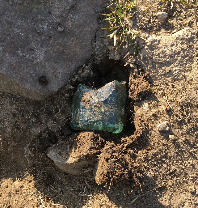
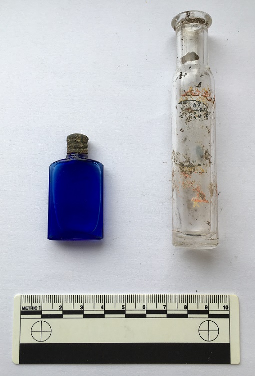
In the meantime, I spotted this sticking out of the ground:
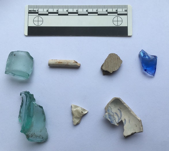
Ooooh, thought I. The greenish colour of the glass gave it away as being older than mere litter, along with the thickness of the walls. Master Hamnett helped me hoik it out of the ground, and cleaned up it looks like this:
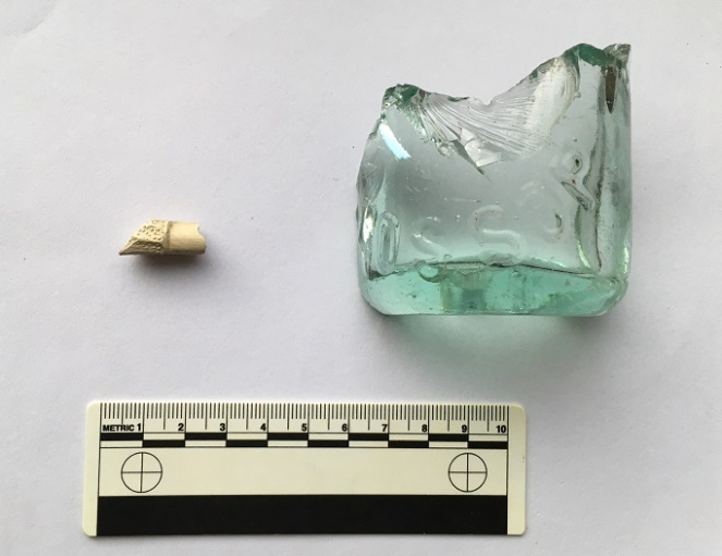
The lovely pale green colour is the result of impurities in the silicone, and dates it to the Victorian period or thereabouts.
You can just about make out the word ‘Glossop’ impressed in the glass. This was likely to have contained either carbonated water or beer, but a brief search of bottles reveals nothing similar. More research is definitely needed.
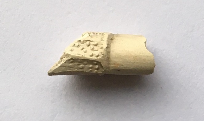
The small white object next to it is a fragment of a clay pipe, but interestingly, it has a some molded decoration on it. Here it is in close-up.
This is a fragment of stem, just at the point where it joins to the bowl. It is unclear what the completed decoration would look like – foliage perhaps? Dating clay pipe stems is always tricky, but the decorated types are usually late, so late Victorian is about right.
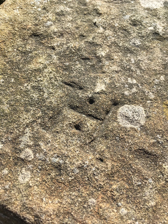
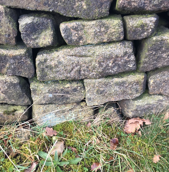
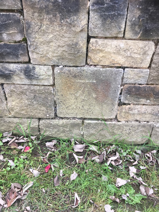
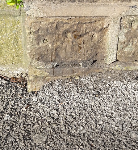
We later came across this stone with the letter ‘H’ carved on it, and being a connoisseur of such graffiti, I had to collect it.
A Hague Street ‘H’
It’s nicely executed with a flourish of decoration in the form of drilled holes between the arms of the ‘H’ – I’d give it a 7/10.
Right. That mystery object… did you get it? I believe you, honestly!
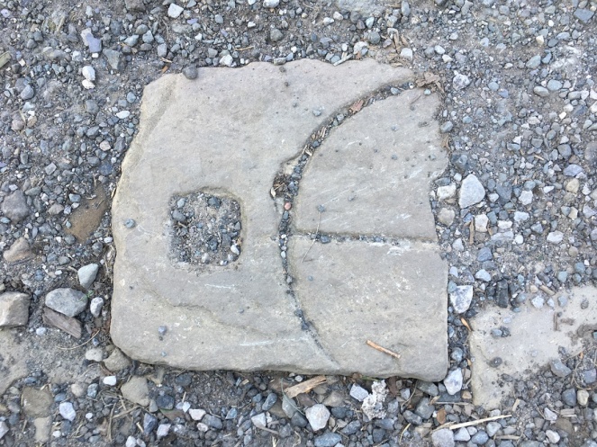
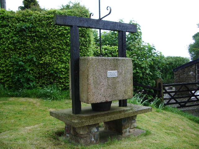
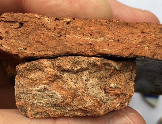
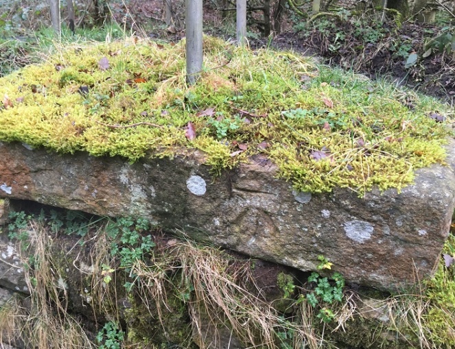
Ok, well, it’s a cheese press. Yes, you read that correctly! A cheese press. A thing for squeezing the whey out of cheese curds. Well, technically, it’s half of a cheese press – it’s missing the right half.
The square hole on the left is to house an upright pole which, along with another on the right, now missing, held the pressing weight in place. The circle and lines carved into the surface allowed the whey to run off, leaving behind the solids which are then matured to make cheese. Cheese was home made, or at least farm made in small batches, until relatively recently, so the press must have belonged to a farm nearby, as you aren’t going to shift that stone any great distance, when others, closer, would do to fill a hole.
The mystery object again.
Here’s a complete one in Bashall Eves in Lancashire:
Cheese press in Lancashire, and used to make, well, Lancashire Cheese. Image shamelessly stolen from Wikipedia.
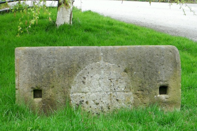
And here is another one carved in the same manner as ours:
The cheese press in Draycott in the Moors churchyard. Photograph is courtesy of their local blog, and I hope they don’t mind me stealing it – please visit the blog here, it’s very good.
This one caused a bit of confusion, apparently – read all about it at this wonderful blog.
In terms of date… who knows? Certainly not hugely old – possibly Victorian, but equally possibly earlier. The only other one I have seen (which is how I know what it is) is propped up where I work at The Blackden Trust, and was in fact carved on the reverse of an old gravestone dated to the early 18th century, which at least gives us a date to work with. I’m going to write a little more about this soon, as it involves two of my greatest loves – archaeology and cheese… if we could just work in wine somehow, then it would be perfect.
Incidentally, the press is currently being used to fill a pot hole in a trackway, which I think is a shame. Sigh… I’ll add it to the list of historical objects things that need to be hoiked out and displayed properly (along with Whitfield Cross and the Whitfield Guide Stoop) – I think it would look great displayed at the wells. Seriously, I think we need to do something about reclaiming our heritage, as it is being slowly eroded. The guide stoop is currently under 3ft of soil, and looks like it will be left like that, So then, who’s with me?
Right. I’m off do some more gardening.
Please stay inside and stay safe, and take care of yourselves and each other.
I love Lean Town – it’s a good walk from my house (even Master Hamnett can do it with the minimum of fuss… mostly), and yet feels oddly distant. The houses are beautiful, and I sometimes feel a tiny pang of jealousy as I pass, so it’s nice to finally do this blog post that has honestly been years in the making. Part 2 is the finds.
Lean Town from the bottom.
As you can see from the above photograph, the houses are perched on the edge of a steep slope. Now, in the Victorian period, there was no rubbish collection – all household waste that couldn’t be fed to livestock, burned in the fire, reused, repaired, sold for scrap, or spread on the food crops, had to be disposed of by the individual. Now, I’ve probably mentioned this before, but humans are essentially lazy creatures. Almost as a rule, they will take only two considerations into account when disposing of rubbish: 1) can I see it? 2) can I smell it?
With this in mind, you can usually tell where a waste dump – or midden – will be by studying the area and asking a simple question: where would I put the it to get it out of my sight and smell, but with the minimum amount of hassle? Houses, situated on a steep slope, hmmm… there’s only one place they would chuck it. Any thoughts?
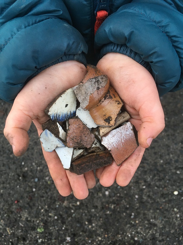
That’s right, well done, you guessed correctly and win a sherd of pottery (please email me with an address if you want it… I have many!). Over the back wall went the rubbish, and on the footpath below that wall went I. And by Jove, what a trove! This was all lying on the surface on the footpath that would have originally led from the houses to the well. Between myself and Master Hamnett we cleared out all we could see, but wait for the next rainfall, and more will pop up.
A proud parent! Master Hamnett was so excited to be picking the pottery up, stuffing it into his pocket, and walking along holding some in his hand. Like father like son…
So, what did we get? The short answer is masses of early Victorian to Edwardian bits and pieces – woo hoo! I divided the slope area into two sections: one directly below the back wall of the houses, and one a little further west along the slope.
The assemblage from below the houses. Very impressive, and with some interesting bits in it.The assemblage from further west, also impressive.
Truthfully, they are both rubbish dump areas from the same set of houses, but old archaeological habits die hard, and it is easier to keep them separate than it is to re-separate them if I needed to after joining the groups. In pottery analysis we call this “splitting” as opposed to “lumping” – once lumped, pottery is almost impossible to split.
I’m only going to discuss the ‘interesting’ sherds here – there is a lot of it (see pictures above), and life is too short. As a pottery specialist, I have a system that I follow when studying pottery, the short version of which is that I look at only ‘feature’ sherds (bases, rims, handles, and decorated sherds), and discount the rest (there is also a very much longer version, believe me… I can talk for hours about it).
So then, here we are with the interesting bits. First up, below the houses:
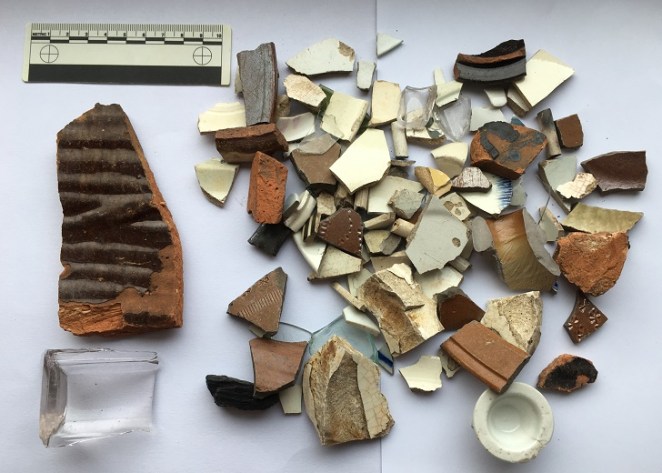
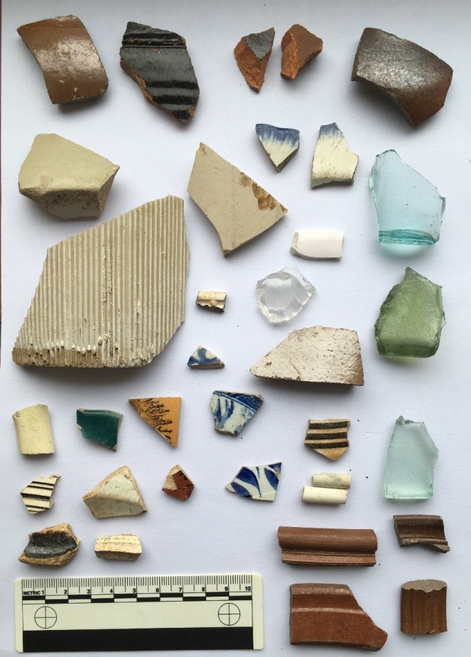
The interesting bits from directly below the houses.
Top row: glass side to a square sauce bottle – possibly HP sauce, but certainly very common in the Late Victorian period; one can’t help but think their food was quite bland. Upper rim is from an open bowl, possibly a cooking pot. It measures 20cm in diameter, and is glazed in what appears to be a slip-ware glaze, which puts it late 18th early 19th century. Lower rim is from a stoneware open bowl with a flat lip, measuring 24cm in diameter – probably a mixing or serving bowl, and mid-19th Century in date. Next to that, the top to a stoneware ink or beer bottle, mid to late 19th Century – I love this, aesthetically, it just so pleasing. Next to that a very fine impressed mug or tankard, 10cm in diameter, with purple glazed body. This is very delicate and fine, and the impressed pattern is lovely, it’s possibly Wedgwood, but if not it would nonetheless have been expensive – which makes me think.
On the left we have a large sherd from a pancheon (a large milk or mixing bowl), with the interior, rim, and upper exterior surface glazed. Here we can see the upper exterior, with the classic dripped surface, which, rather than it being the result of a mistake, is a deliberate decoration. This example is very interesting, as it has been given a manganese ‘mottled ware’ glaze, rather than the usual black, which makes me think this is an early example – mid to late 18th Century, I would say. You can see a more common black example next to it, complete with external drips. Sherds from pancheons are quite common, due in part to most people having one, but also to the fact that they are large (larger examples can be 60-70cm across), which means they produce many sherds when broken. The clay they are made from is always reddish-orange, with pale yellow or grey folds badly mixed into it – don’t ask me why, but it is always so.
Greyish yellow folds within the clay. Is it odd that I find that quite appetising? Actually, perhaps a more important question is should I have shared that information with you, gentle readers?
Above the black pancheon sherd is a sherd of our old friend the feather edged ware bowl. It is another rather nice pearlware vessel, measuring perhaps 20cm in diameter, and was probably a shallow bowl with a flat edge. I have recently done some research on this type, and suggest a date of 1800-1830 for when this was made, which fits perfectly. A quick archaeological aside: when made, and when thrown away are two very different things – I have some of my grandmother’s crockery which I still use, and which must be at least 70 years old. Heirlooms like this do crop up in archaeology, and can cause problems, but generally, I would suggest that 10 years is probably a good innings for an average plate or bowl, especially when you remember there were few carpets and a lot of stone flagged floors.
The green glass fragment has the letter ‘F’ impressed on it, and is late Victorian or later. Next to that is a base to a delicate pearlware eggcup, measuring 4cm. Again, this is quite nice, as is the pearlware base and rim next to it (rim diameter of 18cm so a small plate or soup bowl). There are some spongeware sherds, and some blue and white transfer printed bits, including a green example which quite frankly shows how crappy some of these mass produced pots are – if you look closely, this one has a broken transfer roughly fitted together before being glazed. Above this, there is a moulded base to another very fine 18th Century tankard or mug. Below that, there is a creamware moulded bowl rim, probably quite early (1790-1800?), and again probably quite expensive. Finally, we have a group of stoneware vessels – bowls, storage jars, and the like. These are fairly standard, with impressed decoration (flowers, rouletting, and undulating lines), and date to, well, the Victorian period – made continuously, they were very utilitarian and common.
Next…
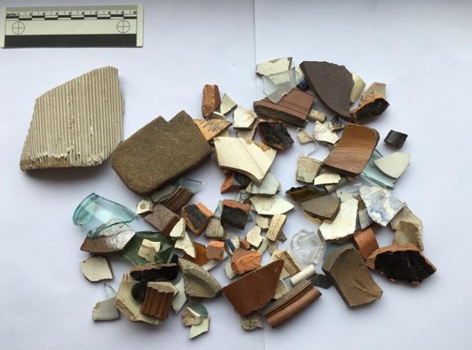
The interesting bits from further west.
Top left, is a large, rounded stoneware bottle or closed shape of some sort – beer, perhaps? Certainly Victorian in date. Next to it is a black ware sherd, with an inscibed decorative band on the exterior, and dating to the late-18th and early 19th centuries. The shiny glaze is the result of lead being added. Far right on the top row is a salt-glazed stoneware sherd, again from bottle, and you can just make out where it forms into the neck. This is interesting, as it looks like it is a continental stoneware – imported gin, perhaps? Below that is a base fragment from a small sauce or syrup bottle – the glass is early, judging by the colour, so perhaps mid-Victorian, but do continue into the 1920’s. These are normally hand blown into a mould, and have a rough rim where it is cracked off the mouth piece – check out a good example here. Actually, the whole website What The Victorians Threw Away is an amazing resource – essentially run by another lunatic like me, if you like this blog, you will love that whole project… it’s basically what I would like to do if I had the time and money (donations always gratefully recieved!).
To the left of that is a pair of feather edge fragments, both on a pearl ware background, and both of the same age as the above example. Below these is a clear glass cup with a handle; it’s moulded not cut glass, but is nonetheless quite nice and fancy. Below and left of this is a sponge ware sherd, possibly from a plate, and probably dating to the 1850’s. Above that (ignoring the tiny sherd) is a large fragment of a stoneware jam jar, and to the left of that is a large stoneware storage jar. The base diameter of this is 20cm, which makes it a monster – possibly a cider flagon, or similar. What is interesting is that it has a lot of wear on the bottom, meaning that it has been taken off and on a shelf or floor many times, and suggesting that it was refilled.
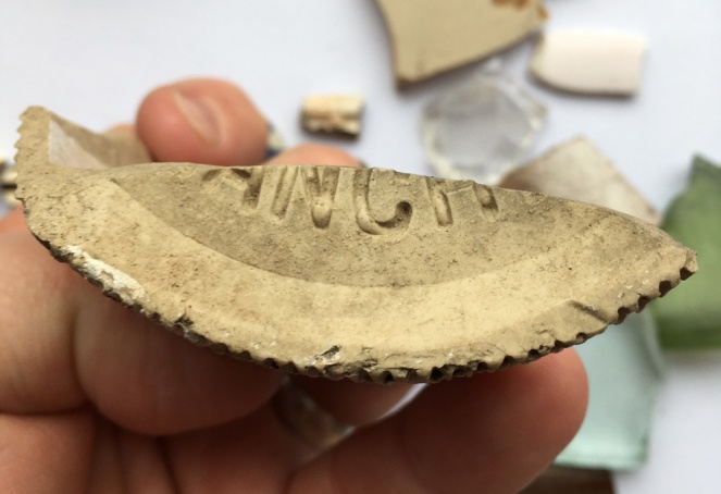
Below that is a large, roughly made, sherd from a large (2lb) stoneware jam jar, with the characteristic vertical fluting – once recognised, always seen! This has part of the base intact, with the words “ANCH” impressed into it.
I love it when I come across words. You can see clearly the stoneware fabric, and the glaze peeking through from the sides of the jar
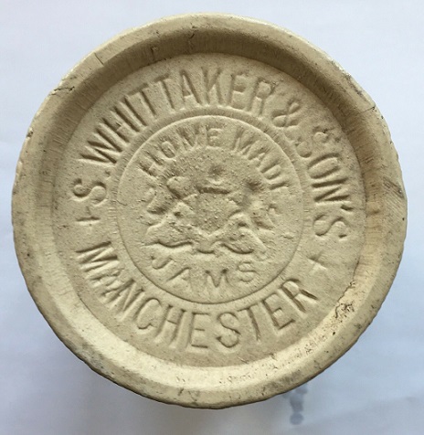
Unless it was ‘ANCHOVIES’, this could only be “MANCHESTER”, and thus it has to be a Whittaker & Son’s jar, the base of which would have originally looked like this:
Love it! Moving on, below this, there are some random sherds, including four interesting ones. Top right, with the black tree on a brown background, is actually from a Mocha Ware pot, and would have originally looked something like this:
Mocha Ware. I can’t make up my mind whether it is truly hideous or whether I like it?
The tree like effect is created by applying, amongst other things, tobacco juice to the slip, where it spreads to create the effect you can see. In terms of date, it begins to be made in the late 18th century, but this is probably early Victorian. There are other Mocha Ware sherds throughout the pile I found in Lean Town (for example, the sherd immediately below this one, or the two sherds below the bottle top in the first photograph), so it seems to have been quite popular here.
In the middle of the group is a base to a pearl ware bowl – quite fine, again, and small, with a base diameter of 6cm. Bottom left is an open bowl of mid-late 18th century date, in a slip-ware glaze. Right of that is another very fine tankard with a moulded base, and dating again to the late 18th century. To the right of the group, there is a delicate blue painted porcelain fragment, again thin and very fine, and quite expensive. To the right, we have some clay pipes – nothing interesting there, I just like them! Below them there is some more of the brown glazed stoneware – bowls and jars, and including a handle from a hefty jug, which in my mind was filled with frothy home-made ale (but then, to be fair, most thing in my mind are).
That’s the end of the pottery, but now for the other material. In archaeology we make a distinction between what we call ‘bulk finds’, that is, material (usually pottery) that occurs in large quantities, and ‘small finds’, which are individual items, unique to the site or objects that can tell us more about the site than the bulk finds. Often there is overlap – a piece of pottery with an inscription, for example – and usually the small finds are what most people would call ‘the goodies’! And so it is here:
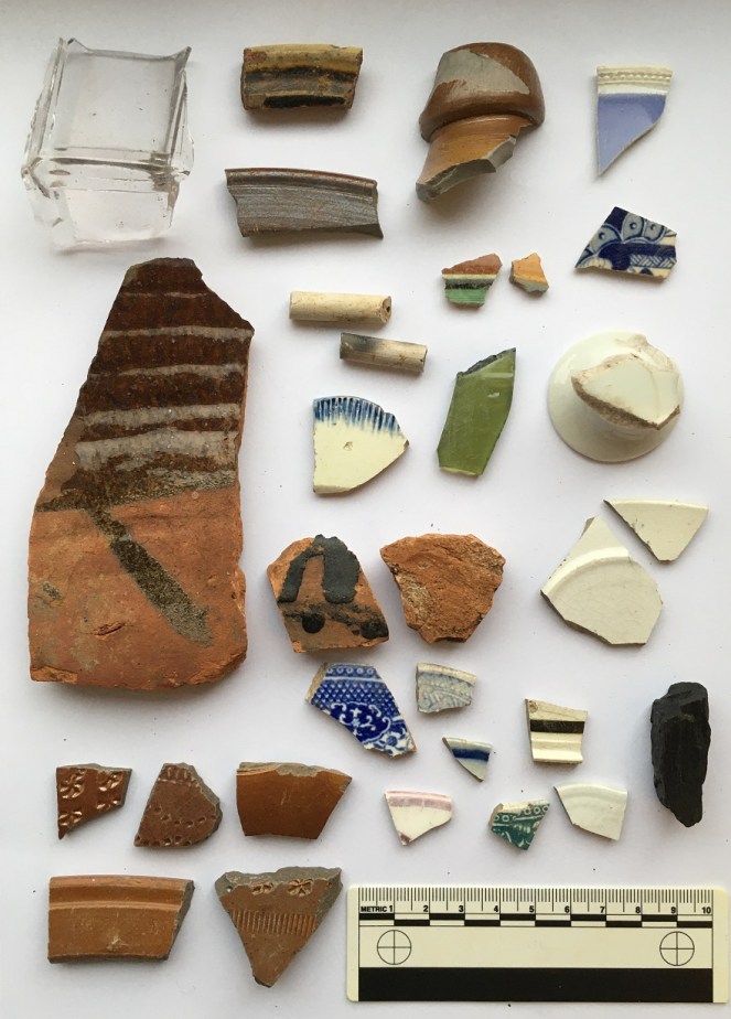
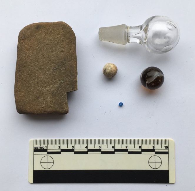
The small finds.
The stone on the left is, I think, a whetstone, used for sharpening knives. It is flat on both sides, worn on the surface and edges, and is the perfect shape, size, and stone type. It was probably discarded after being dropped and broken. Top is a glass stopper from a rather nice serving jar or wine carafe. It’s very delicate and beautiful – hand blown and hollow, with delicate cuts to give it a texture and grip around the top. Below this are a pair of marbles – right is brown glass with a white ribbon running through it – it’s worn, well loved, and certainly late Victorian. Left is a small, roughly made, ceramic marble, partly glazed and misshapen. Possibly early Victorian in date. Bottom is a tiny (2mm) glass bead, possibly from a decorated bag or similar. It’s lovely, and one assumes it was lost in the house, swept up, and thrown away with the rubbish. Don’t ask me how I spotted it… it just stood out against the soil.
So there we have it, Lean Town via the rubbish it once threw away, but what can we say? Firstly, the date. A lot of the material dates to the late 18th and early-mid 19th century, that is to the first decades of people living in the houses here. This is interesting, and suggests perhaps that in the late Victorian period, they buried most of their rubbish elsewhere. The second thing that stands out is the quality of the material – it better than you would expect from a simple worker’s household – some of it is very fine and tasteful, and it seems to have been expensive. Certainly the fine tankards, and the possible Wedgwood cup were, but also things like the glass stopper, the porcelain, and the pearl ware – not what I would expect from a humble mill worker’s house. I would suggest that after building it, Elizabeth Hampson lived here, or if not her, then someone like her – someone fairly well-to-do with taste. A little more research might reveal much more.
*
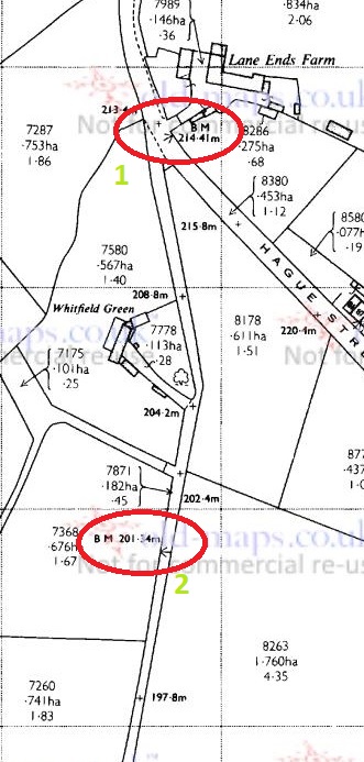
And finally, of course, what’s a blog post without a brace or two of benchmarks? There were several marked on the map:
The upper part of the lane and…The lower part of the lane, including Lean Town itself and the footbridge.
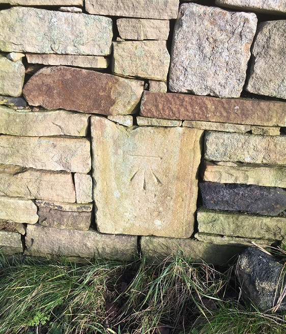
Number 1 was easy to spot, although I suspect that the wall has been rebuilt, so it might not be in exactly the correct spot. Nonetheless, excellent work by whoever rebuilt the wall to include the benchmark – very conscientious! Here it is in all its glory.
This is what 705ft above see level looks like. Probably. I love the veining on the rock its carved on – each line representing a splashing wave laying down sand on a beach millions of years ago. Wow, that got deep!
Number 2 was also an easy spot, on the wall leading down.
This one is a bit worn, and seems to have been made sometime in the 1950’s or 60’s, as it doesn’t show on the earlier OS maps, so we have to go metric for this spot height – 201.34m above sea level (which Google informs me is 660.5ft in old money)
Number 3 should have been on the south east corner of the row of houses – I looked and couldn’t see anything (I didn’t look closely – nobody wants to be ‘that man who peered over our gate’, that’s how rumours start). According to this bench mark spotter’s website, the mark is definitely still there, but alas, I have no photo to show you.
Number 4, however, was there, on the stone base to the bridge across Bray Clough Brook.
The bridge has never struck me as being particularly old, and the bench mark doesn’t show on maps until the 1960’s, so I presume this is contemporary with Number 2 above. Anyway, here we are at 180.85m above sea level.
Bray Clough Brook joins Long Clough Brook a little farther upstream, and in turn it joins Glossop Brook at the bottom of Primrose Lane – I blogged about the confluence here.
Right then, I think that’s about it (I can hear you, you know, breathing a sigh of relief). I will try and be a bit more frequent in my posting… and try to tackle smaller subjects! When I started to write this, I really had no idea how large a post it would become! But there you go. Please, any comments and ideas are always welcome. More soon, I promise.
Glossop is a town made up of towns, you may have noticed.
I have a blog post about 30% written that describes each of them, but briefly they are: Milltown, Jerry Town, Charlestown, Rough Town, Howard Town, Freetown, Top o’ th’ Town, and Lean Town, the subject of today’s blogpost.
Lean Town is Glossop’s lesser known ‘town’, but is the most easily defined – it is simply a row of terraced houses in Whitfield, at the end of an unnamed track that comes south off Hague Street.
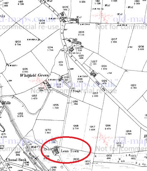
Hague Street runs NW-SE, and an unnamed road runs due south from Hague Street, to Lean Town (circled in red).Lean Town from the south east. the path down to Bray Clough is behind the camera.
The name origins are obscure, and even the usually reliable Robert Hamnett states “why it is called Lean Town, I have never been able to find out” (and he normally knows what he is talking about, does that chap). A number of possibilities present themselves. The ‘Town‘ element is easy and obvious “a township, or community“, in this case used loosely to describe the small group of houses. ‘Lean‘, however, is a bit more difficult. I have always thought it refers either to the land hereabouts – lean in the sense of not very good for growing crops – or the people living in the houses i.e. they were poor. Another possibility is that it refers to the houses ‘leaning’, that is perched on the edge of a steep hill, which they are.
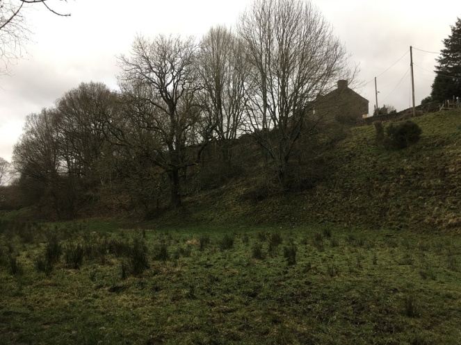
You can get a feel for just how perched or ‘leaning’ they are from this shot, taken from what is essentially the floodplain for Bray Clough, behind me.
Annoyingly, it doesn’t feature in the 3 volume set of The Place-Names of Derbyshire at all, but then that is not surprising, as the book is woeful in its shortcomings, leaving out dozens of local place and brook names that I know of – there must be thousands more. However, looking in the much more comprehensive The Place-Names of Cheshire for similar sounding possibilities gives the following:
Lyng (Old Norse), ling, heather.
Given its location on the edge of the common land that was, and still is, covered in gorse and heather, I am now starting to lean* towards that as an explanation. Over time, Lyng, the name descriptive of the area, becomes Lean, and is then attached to Town – Lyng Town/Lean Town. Perhaps. Maybe. *Pun fully intended.
Is this the origin of Lean? Heather and gorse just by Lean Town.
Anyway, let’s move on!
According to Hamnett, the houses here were built in 1806 by Elizabeth Hampson, a member of a well known local family, who were responsible for building large numbers of the houses in the Whitfield area. Originally there were four terraced houses of a typical late Georgian/early Victorian design, stone built, with stone mullioned windows, and a stone roof. I’m not sure how many houses are there now, or whether any have been knocked through – there are still four chimneys, though.
The date of construction fits nicely with what we know of the area, which was radically changed at the end of the 18th and early 19th centuries, when the area was enclosed. The process of enclosure saw what was previously ‘common’ land, available to all, was closed off and sold to private individuals. These landowners built walls around the fields, creating the landscape that we know so well; prior to this, the whole area was just open moorland and fields. Indeed, the gate to the moor here was situated at Lane End Farm – as the name suggests, here the lane, or Hague Street as we now know it, ended, and beyond it was just common moorland. With the sale came certain stipulations laid down in law, particularly the creation of roads, and many of the roads in this area were created at this time: Kidd Road (originally called Whitfield Green Road), Derbyshire Level (originally called Hurst Road), Hague Street, and even Gladstone Street. All were declared public carriageway, and were ordered to be 30ft wide (go get a tape measure and have a look!). The unnamed track, at the end of which sits Lean Town, was created in c.1813, it was declared a bridleway, and ordered to be 10ft wide. Presumably it replaced an earlier path down to the houses, unless the dates are slightly off. What is interesting is that the path marks the limit of the ‘ancient enclosure’ (that is, the medieval or early modern enclosures) – if you stand at the top looking down to Lean Town, all that is to the right of you is ancient, and to the left of you all was common land until the early 19th Century.
The walled space at Lane Ends Farm dedicated to Norman and Irene Greenhalgh of Lane Ends Farm. To the left is Kidd Road, to the right the unnamed path down to Lean Town.Behold, the unnamed path down to Lean Town. A bridal path built in 1813 or thereabouts, and by law to a width of 10ft. It probably replaced an earlier path to the houses from Lane Ends.
Like I say, a huge upheaval – people lost their right to graze livestock, and even the right to cut peat for fuel for their stoves . The peat fields were moved much farther away, but I believe that residents of Whitfield still have the right to cut peat – don’t quote me, of course, and I’m not sure a multi-fuel burner could handle peat to be honest. There is an interesting account of the process of enclosure in Whitfield here.
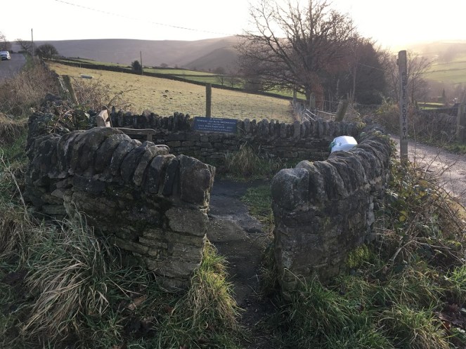
If you look at the map above, you can clearly see marked ‘well’ at the end of a path from Lean Town. Now, having a thing for wells, I obviously set forth to see if anything remained. No, was the short answer. Here is the location, and the area is wet, but there was nothing that might be termed ‘well’. Ho hum.
The location of the Lean Town well. I’m not sure what was here originally – perhaps just a trough, or spring head, but there is nothing there now, alas.
Right ho, that’s the end of Part 1. Part 2 contains all kinds of goodies in the form of finds, (lots of) pottery, and bench marks… what’s not to love? Oh, and a witch! You can hardly contain your excitement, I know, and I feel the same. It’ll be up soon, honestly – it’s almost done.
What ho! What ho! What ho! Here is another post, as promised. This one is something of a hash, with multiple elements sharing the theme of Freetown (the road in Whitfield, not the capital of Sierra Leone, just in case you are here by mistake), and all presented in the style of a thriller novel. Enjoy.
The House(s) of Horror
I was perusing my namesake’s History of Glossop the other day, and came across this:
Freetown is really part of Hollincross Road (now Lane); it was called Freetown on account of the land being mostly freehold. The oldest house is no 28 built in 1809 and long owned and occupied by Robert Bennett. The chief rent was sold 29th June 1891 to Mrs. Wood for £52 who also bought the chief rents of the Unity Street property. No 28 was sold 16th January 1893 to Ald B. Furniss for £445, it has an outdoor licence attached to it.
The late Mrs. Sarah Hargreaves of Hadfield Street, remembered Freetown when this house was the only house in the road. On each side were hedges right down to Pikes Farm. The next houses to be built were Nos. 36 and 36a, in 1830 by Peter Handford, better known as “Peter before the Shower.” Many houses were built in 1835 and 1836 but the majority now existing were built during the last 60 years.
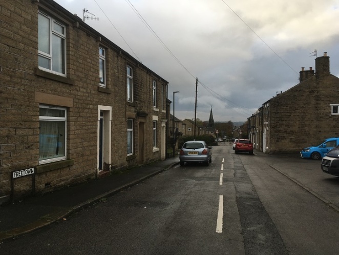
I live just by Freetown, and as I walk up and down it at least 8 times a week dropping off and picking up Master Hamnett from school, I have become very familiar with it.
Freetown, looking west toward St James’s church.
It really is quite an interesting place; 1860’s housing cheek by jowl with 1960’s housing, and where widespread ‘remodelling’ in the 1960’s destroyed the homogeneity of the Victorian stone built heart of Whitfield. A shame really. I have mentioned bits around Freetown before (here, for example), and I’d really like to do a longer piece, particularly on Whitfield recreation ground (the park), but for now, I’ll keep this brief(ish)!
Anyway, the article got me wondering… and wandering. Are these old houses still in existence, and what else is interesting here in the Freetown area.
Well, the first part of the question was easily answered.
No.
The council pulled them down in the 1960’s. With no thought to heritage or the past in any form. I am constantly amazed and appalled at the shortsightedness of councils in the 1960’s – no effort was made to preserve, only to destroy and rebuild in a ‘better’ way. This thinking has had so many effects in the present day, not least of which is the destruction of close-knit multi-generational communities in Manchester in the name of ‘slum clearances’. I can angrily rant and rave about this all day, so I’ll move on.
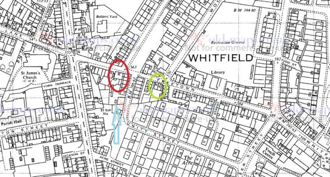
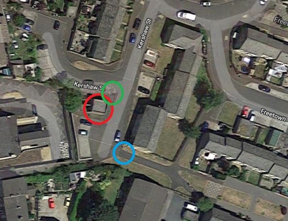
Number 28 is marked in red, 36 and 36a is marked in green. Ignore the blue arrow for now… we shall return to it.
This is the 1968 1:2500 map, just before they were demolished.
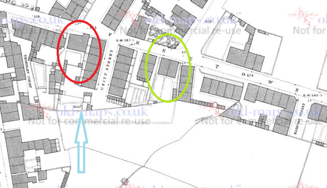
What is interesting is that the roads Wood Street and Kershaw Street seem to have been aimed at them, almost as though the town planners were using these early buildings as reference points – which they almost certainly were. Kershaw Street (begun in 1834) runs from Bank Street to Number 28, and Wood Street (in 1913 was still under construction, though there as a track prior to that) runs from the opening toward St Mary’s School (and the allotments) off Gladstone Street to Number 36 and 36a. Here are the buildings in 1880, in much better focus.
The 1880 1:500 scale… much clearer. And once again ignore the blue arrow… nothing to see here.
28 (red circle) seems to have been a large, oddly shaped, affair, and probably quite Georgian looking, with a central doorway and large windows. Actually, I’m amazed no photographs exist of 28 prior to its demolition – I should peruse the Glossop Heritage Trust archive for some – you never know what might be lurking. Here is what it looks like now:
The location of 28 Freetown, the oldest building in the area.
Number 28 would have occupied some of the same space as the building there now, and to the right, but would also have come up to the edge of the path, where the grass is. It’s nice to know that at least some of the footings and foundations will be preserved below ground, and it makes you wonder at the sort of pottery and bits that lurk in the garden there… Given how busy Freetown and area is, and how many houses are here, it’s hard to picture what it would have been like as Sarah Hargreaves remembered it, with this being the only house from here to Pikes Farm – amazing.
Numbers 36 and 36a (in green) were semi-detached (well, terraced) stone built affairs, probably very similar in design and style to many of the other houses built around the same time in the area. I love the nickname given to the builder, Peter Handford – ‘Peter Before The Shower’ – what on earth could it mean? Any thoughts, anyone?
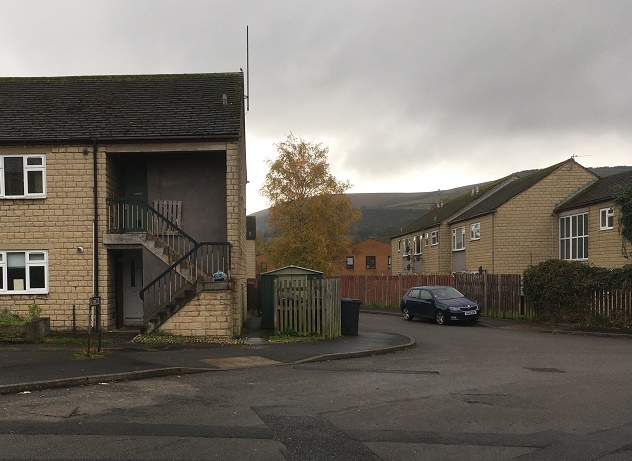
Anyway, here is what is there now:
The modern view, Whitley Nab in the background.
Numbers 36 and 36a stood broadly where the right side of the current building is, the shed, and out into the road – in a sense, the centre of the photograph.
So there we have it… a loss of history, sadly. I wonder if the people who live there now know what they are living on (if you are reading this, can I have a poke around your garden?).
The next three parts of this post are all based around this small area, so we’ll skip to an aerial photograph of the place, with each area marked in coloured circles. All will become clear in a moment, don’t worry!
It’s all getting a bit ‘Olympic-y’ around here now.
The Blue Arrow
So, that blue arrow! whilst I was sorting that lot out, and doing some map work, I came across mention of a well (check out the blue arrows in the above maps, you can see it). A well would have been important to the people of Whitfield, as they always had issues with the water supply in the area (this is a whole other blog post, we’ll save it for another day). The word ‘well’ implies a reliable water source, and importantly, some form of structure associated with it – even if only a trough. Indeed the 1880 1:500 map (above) shows just such a structure, with the well placed against what seems to be a wall. I had high hopes of finding something.
Alas, ’twas not to be. There is quite literally nothing even remotely old about any of the area where the well once stood – it has all been remodelled. Here is the location of the well as marked on the map:
This place is circled in green in the aerial photograph above.
I would think it would be difficult to destroy a well completely – it is flowing water after all, and if you stop it up, it will just bubble elsewhere. This, coupled with the fact that it is not marked on any map past 1880 suggests that it might have simply dried up. Oh well.
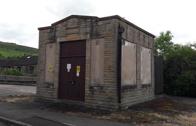
The Electrifying Edifice
So, right next to the well location (and circled in red) is this:
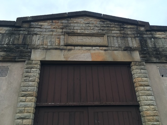
A vaguely classical temple looking electricity substation, sitting seemingly on its own in the wilderness of this part of Kershaw Street – it’s all a bit spooky, and I have the sneaking suspicion that the ‘Danger of Death’ notices refer not to the electricity, but something that lives inside it. It’s probably 1920’s or 1930’s in date, and clearly supplied power to the area, and indeed still does, quite remarkably surviving the 1960’s demolition. Above the doorway is a lintel with the letters ‘SHMD’ carved into it – a sure sign of its age, as it would just be a plastic sign now.
The Stalybridge, Hyde, Mossley and Dukinfield Tramway and Electricity Board
A brief search on the internet reveals that it refers to the “Stalybridge, Hyde, Mossley & Dukinfield Tramways & Electricity Board”. They have an interesting history in this area (which you can read about here and here), but briefly they were founded in 1901, supplied electricity to the named places (and Glossop), as well as running bus services and trams, and eventually became part of Norweb in 1948. So there you go.
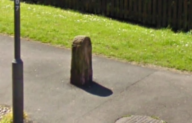
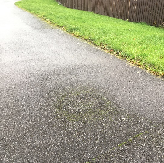
The Mystery of The Disappearing Gatepost
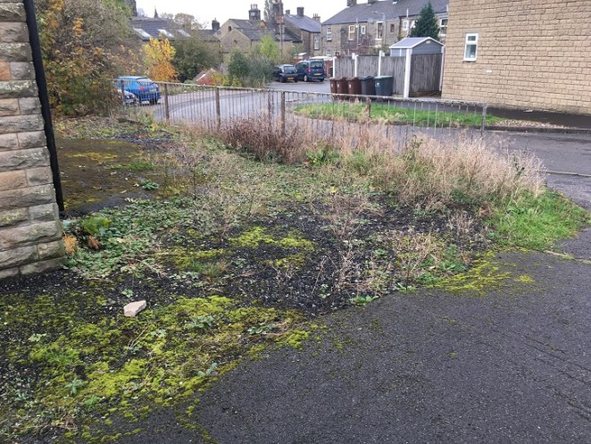
As I was navigating the streets via Google maps, trying to work out where the well was, I spotted something interesting at the very bottom of the continuation of Kershaw Street, at the left hand (easterly) turn along a pedestrianised track (circled in blue in the above aerial photograph).
Carved, and covered in paint, it stands guard.
It looked to me like a very out of place gatepost, reused as a bollard to prevent ne’er-do-wells riding motorbikes and cars along the pedestrianised bit. You can even make out the carved shoulders, making it reminiscent of a milestone (and here). It is certainly jarring against the 1960’s concrete that is used in this area. Interesting, thought I.
So off I popped to have a look.
Nope. Nothing. Just a tarmacked hole in the ground where once it stood.
A patch of tarmac is all that remains.
I had a look around in hedgebacks and ditches, but found nothing. Something has happened to it since May 2009 when the Google streetview image was taken… but what? Now, nobody has stolen it, clearly – it would weigh a serious amount. And if the council took it away, then why? It’s all a bit of a mystery; if anyone knows anything, then please drop me a line.
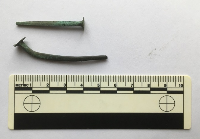
The Nailbiting Conclusion
And to end with, some archaeology. As I’m sure you know, I like to pick up interesting things that I find (I can hear Mrs Hamnett sighing in agreement). Now, within the space of a single week, I picked up two copper nails from Freetown; one at the upper end, and another at the lower, nearest St James’ church. I love these things – such history in a tiny object – and I’ve blogged about them before, here. And have also come across them elsewhere in Glossop.
I love these things.
I always have my eyes on the ground (to the point I am worried about developing a stoop!), but to find two in a week seems oddly lucky… perhaps I should play the lottery. Or has my luck been ‘used up’ on worthless copper nails? Anyway, keep looking people, and get in contact with anything you find.
Right-ho, that’s about all I have at the moment. A bit of a hotch-potch, to be honest, but I hope entertaining, or at least diverting. If you have any comments about the blog post, or just in general about Glossop’s past, please feel free to email me. I have a lot more bits and pieces to blog about, and am trying to better manage my time, so hopefully I’ll have something more to you in the next week or so. Until then, I remain.
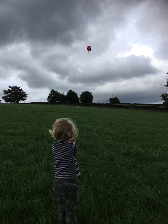
A brief one today. Taking advantage of the lull in the rain coupled with a bit of a breeze, Master Hamnett and I went to fly a kite in the fields off Hague Street. On the way back, I found some bits of pottery which spurred me into doing the blog post that I have been thinking of doing for some time.
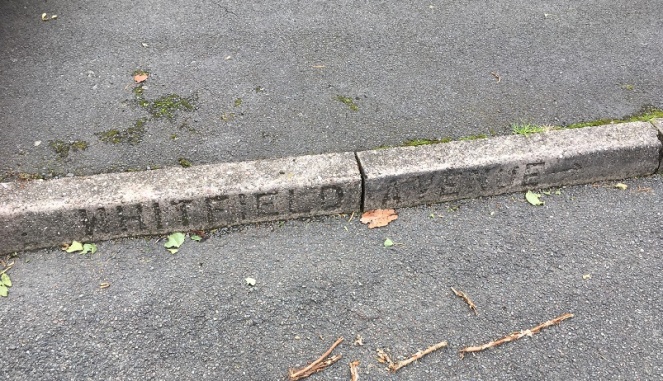
Just in case you get lost. Actually, it’s a nice touch, and I wonder where else the impressed concrete road names were placed.
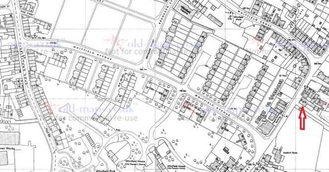
Whitfield Avenue runs downhill in a broadly NW – SE bearing from Hague Street to meet with Charlestown Road, and is parallel to Whitfield Cross.
Whitfield Avenue runs north-west – south-east. For orientation, The Beehive pub is indicated by the arrow. (1974 OS map)
At first glance, it is not a particularly interesting road. The product of the 1960’s demolition and rebuild of the Whitfield area, the road didn’t exist prior to this, as you can see from the map below.
This is the 1921 OS map, and again, The Beehive is indicated.
What is there is a footpath, walled for most of its length, along the long thin fields that characterise the fields of Whitfield – possibly a survival of the medieval ‘croft and toft‘ field system, or more likely a result of the enclosure of the land there in the early 19th Century. This is interesting, as we shall see, but it also probably explains why the council chose there as the location of the road – using an already existing path.
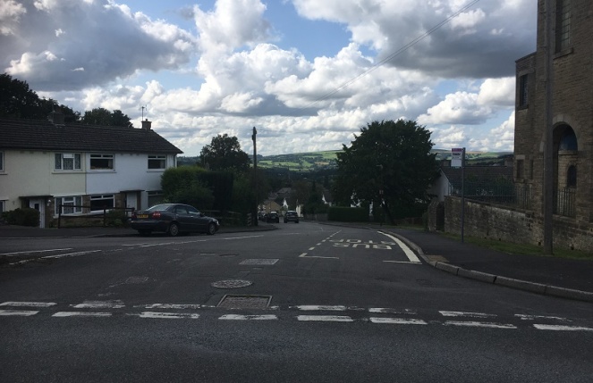
Whitfield Avenue from Hague Street looking down to St James’s Church and Charlestown Road. On the ridge line in the distance, on either side of the left hand tree, is All Saints Mottram (left) and the Deep Cutting at Roe Cross (right).
Historically, then, it is interesting, but not exactly earth-shattering. That is, until you peel back the modern, and take a closer look.
Hague Street was the original packhorse road from Chapel en le Frith to Glossop (now, Old Glossop) – there is some discussion about the road, here, and there is the Glossop Guide Stoop, too (and more here). It was an important route, and the village of Whitfield grew around it – this is the oldest part of the area. Dating for this road is tricky – we know it was there in the 10th Century, as the Whitfield Cross was placed at the junction of Hague Street and Whitfield Cross (the road), and presumably some form of settlement – perhaps just a farmhouse – was there at the time. Beyond this, however, we have no evidence. However…
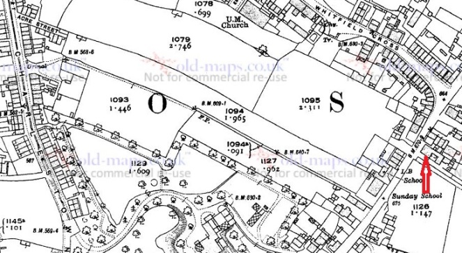
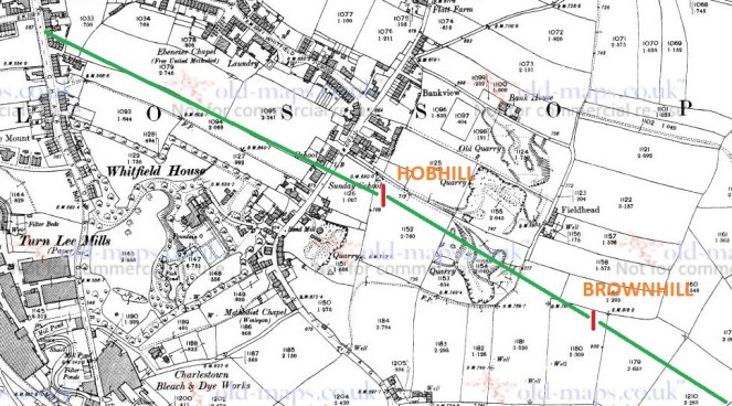
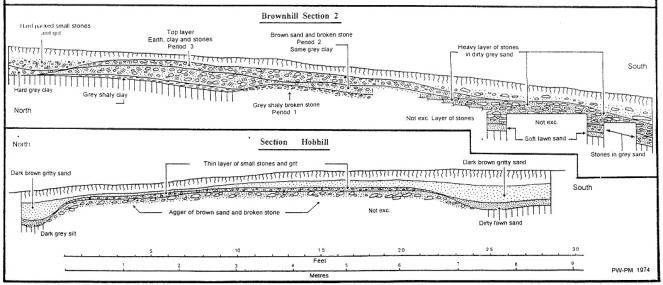
In the early 1970’s a series of excavations were carried out by two archaeologists – Peter Wroe and Peter Mellor – in order to establish the line of the Roman roads to and from Melandra Fort. Although this thorny and difficult subject has been much debated (and only recently – possibly – put to rest), they made great leaps. One of the roads, that coming from Navio Fort (Brough, near Castleton) passes through Brownhill, and comes through Hob Hill Meadows, and continues down the line of what is now Whitfield Avenue. From there it travels down the road that are now known as Hollincross Lane and Pikes Lane, and over into the fort.
Yes, you read that correctly, Hollincross Lane/Pikes Lane, especially its latter part toward Pikes Farm, is a Roman road.
The line of the Roman road is shown in green, leading down what will become Whitfield Avenue and onto Hollincross Lane and Pikes Lane, and then to Melandra Fort.
The excavations not only revealed the broad line of the road, but also how the road was built. The next picture shows what is called an archaeological section drawing – essentially a slice of the road was taken out, and the side of the slice was drawn showing the layers that made up the road. And all this is just 1ft below the ground, which is quite remarkable.
The upper section shows what is marked ‘Brownhill’ on the above map, the lower shows ‘Hobhill’. The road is very clear, and very large, too.
Interestingly, and as an aside, Hob Hill as a placename means ‘Devil’s Hill’ – I have said it before, I love it when folklore and history meet.
The ‘original’ footpath on the first map pretty much follows the line of the Roman Road. This is interesting, and suggests that the path used the surface of the Roman road, or a later incarnation of it; there is no point in making a new path if you can use an existing one, especially if that one has a good surface. What I like about this is that a road built 2000 years ago, directly dictated to the council the course of a road built in the 1960’s. History affects us in the present in many ways.
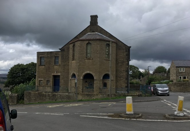
At the top of the road stands this wonderful, forlorn, and if I’m a little honest, slightly terrifying, building – the former Chapel/Sunday School.
I can’t be the only one who gets weird Amityville vibes from this building, can I? It is the ‘house on the hill’ after all.
I have always been intrigued by this building, and so taking advantage of the open gate, I had a look around.
Master Hamnett having a look around.
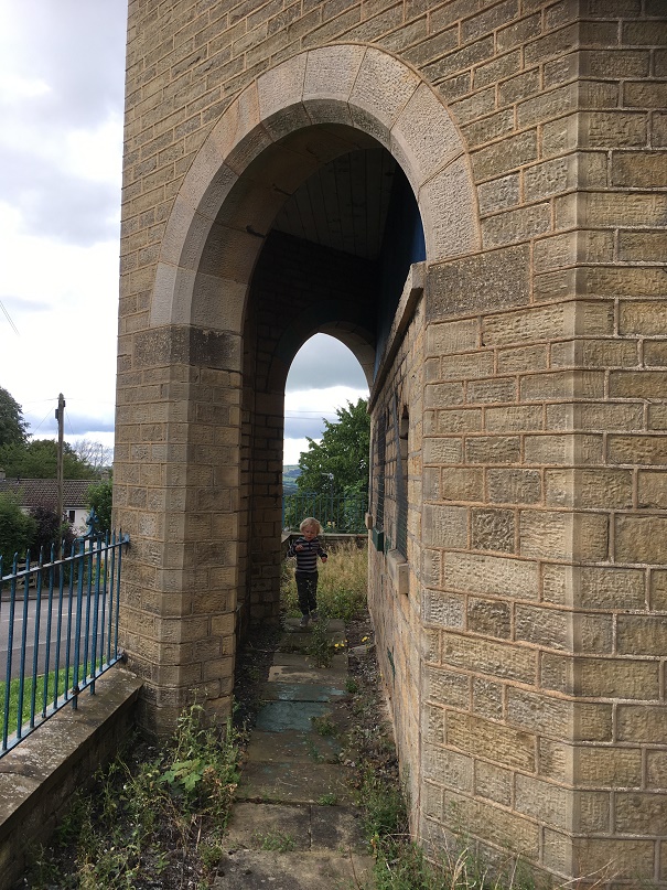
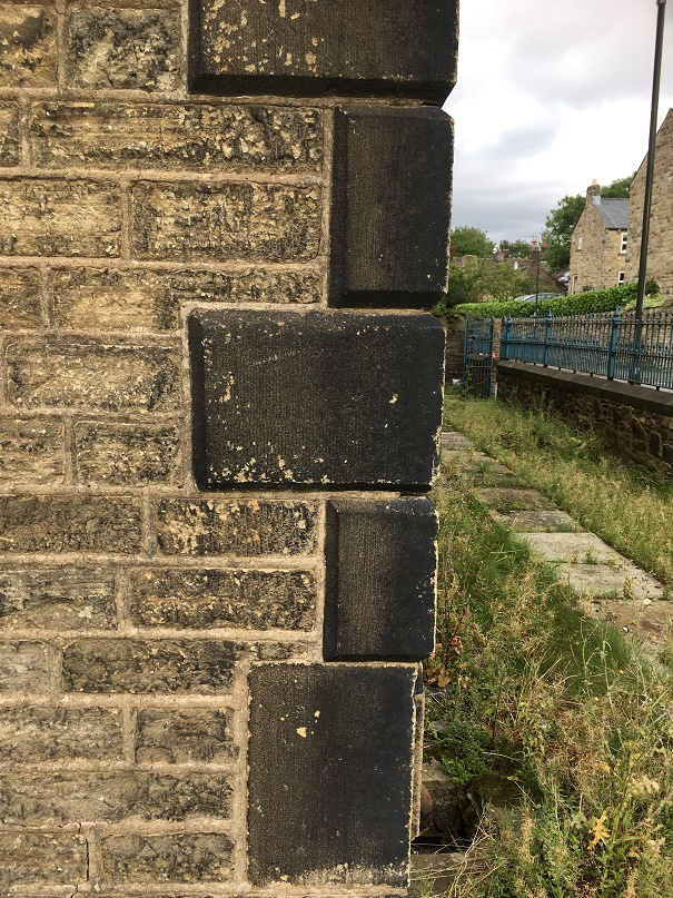
It’s really quite a lovely, if very Victorian, building, full of nice touches.
The quoins give it a rather grand air, with some nice masonry.Ornamental ironwork, sadly in disrepair, and in need of painting. An artful shot looking down Whitfield Avenue – very unlike me!
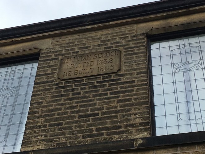
There is also a datestone, helpfully recording the dates of the original construction, the rebuild, and what its function was.
I do love the Victorian literal approach to recording things – it really helps us historical types.
Actually, it was also altered a third time in 1931 to incorporate the chapel further up Hague Street which by then had fallen into disuse. This Methodist chapel (itself rebuilt from the original 1813 version), had once contained the pulpit from which John Wesley had preached, and which in 2010 was returned to its rightful home in New Mills (see here for information and photograph).
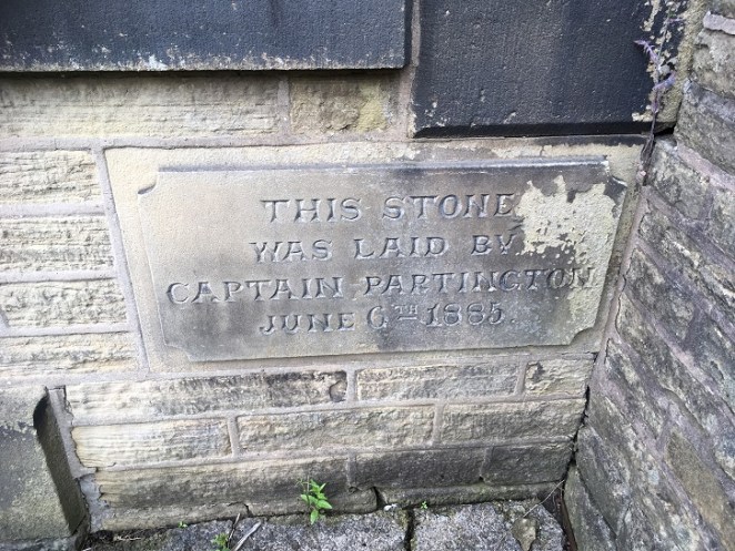
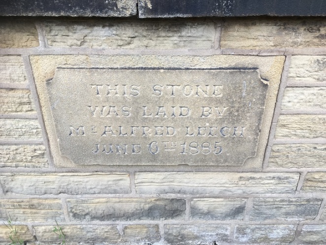
The 1885 rebuild had four cornerstones embedded into it, recording the local worthies who attended the ceremony, and which allow us a peek into Late Victorian Glossop life. Here they are:
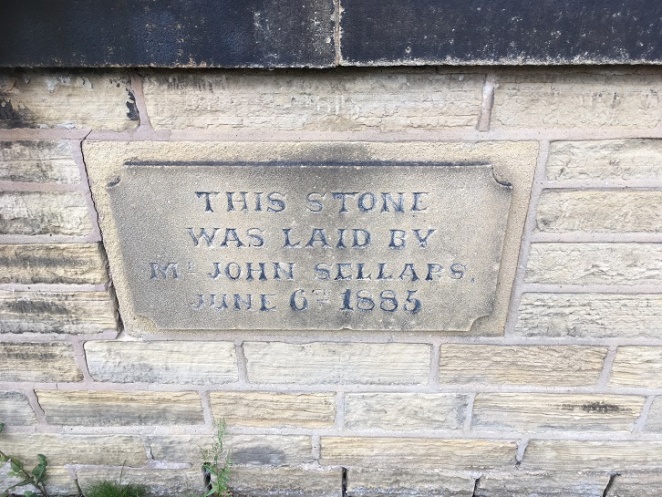
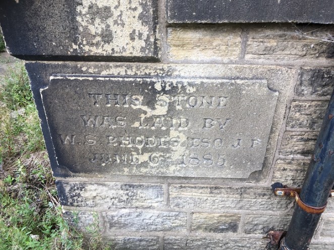
“This stone was laid by Captain Partington. June 6th 1885”“This stone was laid by Mr Alfred Leech. June 6th 1885”“This stone was laid by Mr John Sellars. June 6th 1885”“This stone was laid by W.S. Rhodes esq. J.P. June 6th 1885”
So these are the stones, but who are these people?
Captain Edward Partington: Partington was a very important person in Glossop’s Victorian history – his biography is impressive, but in summary he was born in 1836, and moved to Glossop in 1873, buying up all sorts of mill concerns, and ending up Rt. Hon. Edward Baron DoverdaleRt. Hon. Edward Baron Doverdale, dying in 1925. He did a huge amount of philanthropic work around the town (funding the library, for example), and served as Captain in the 3rd Derbyshire (Volunteers) Rifle Corps. Oh, and was a mean rugby player, by all accounts.
Alfred Leech: There is very little information about Mr Leech that I can find. He crops up in a number of interesting places associated with Glossop society, and he is mentioned in the London Gazette as being elected as a land tax commissioner. His address is given as Cowbrook Cottage, Sheffield Road, Glossop. More research is clearly needed!
W. S. Rhodes: William Shepley Rhodes was a councillor, alderman and mayor for varying amounts of time. The Rhodes family were involved in various mill concerns in the aream and are well known. William was also known as a strong athlete and a good sportsman, being the president of the Glossop Cricket Club for a while.
So there you are – the more you know… or less, in some cases.
The chapel/Sunday school continued in use until Easter Sunday 1968 when it had its last service. It is now known as the Spencer Masonic Hall, and is where, from 1973 onward, the Freemasons Lodge of Hadfield 3584 have met on the first Thursday of each month. And at some stage it was up for sale – the sales brochure can be seen here (complete with interior view!). It’s a lovely building, but very neglected and tatty on the outside, and it’s a bit of shame that something more isn’t made of it.
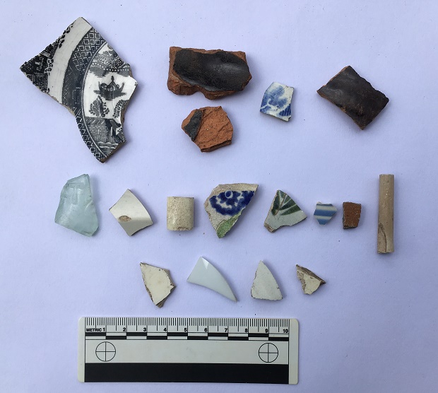
The pottery, then. Obviously it would be nice to find something Roman, but sadly no such luck. Instead, we have a selection of Victorian material, which might be the remains of household rubbish from the houses that once stood there (see above map), but equally might result from the process of nightsoiling. On balance, it is probably the former – there is no arable land in the area where I found the pottery, and the edges of the sherds are still sharp in some examples, and when pottery sherds are ploughed, the edges become rounded. There is nothing too exciting, but nice to see.
A modest selection of Victorian bits.
Top row, left to right: A shallow dish or saucer, transfer printed, and probably late Victorian, but difficult to date. Next to that are two sherds of a large Victorian cooking pot, very characteristic with thick walls, a black glazed interior, and a plain glazed reddish-orange exterior. They are made that way so that the heat can transfer through the unglazed side easily, but the glazed interior means that it is waterproof, and so holds the liquid well; quite clever really! Next is a willow pattern plate – very boring, but is patterned on both sides, so is from an open bowl type of vessel. Next, a glazed earthernware pot with grooved exterior – it’s probably a storage jar or something similar.
Middle row: Victorian glass fragment (the greenish/bluish tinge gives away its date), with a raised letter ‘T’ – clearly a company name or similar. Next, a plain sherd from a flaring rim from a soup bowl or similar; possibly early Victorian, as it has a slightly creamy opalescent glaze. Next, a handle from something – cup or bowl. Next, an early Victorian sponge ware sherd – the blue pattern actually printed, potato-like, on a sea sponge. This is the base to a bowl of some sort (base diameter is 12cm, so not huge), and judging from the wear on the ring foot, was a much used and loved bowl before it was broken. Next, a sherd from a large cup or similar (c.15cm diameter), with transfer printed decoration. After that is a blue and white striped fragment, probably from a cup or similar. Next is a stoneware fragment from a storage jar or similar, fairly bog standard (there is some discussion of the type and the method here). End, is a clay pipe stem (from toward the bowl), and has a some nice paring marks on the body, but is fairly boring stuff (although I do love them).
Bottom row: All featureless white body sherds.
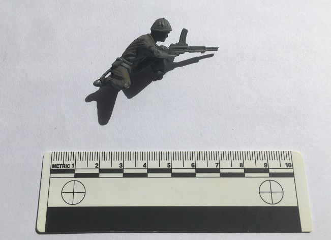
As I said, overall a fairly standard, if uninspiring, collection of Victorian pottery, and almost exactly as one would expect to find (although I do like the spongeware!). The best find, however, was found by Master Hamnett amongst the rubble and rubbish outside the Masonic Hall.
C.1980 vintage plastic soldier, courtesy of eagle-eyed Master Hamnett.
This was pretty much my childhood – plastic soldiers at a 1:32 scale. Whilst this one is not Airfix, it is still a good quality World War 2 figure – possibly Polish or Russian to judge from the helmet and gun. He’s lost his foot, and his stand, but to his credit he’s still fighting. Interestingly, he was also painted at some stage, too, and not professionally, so I think he was a much loved toy (if anyone recognises it, I’ll happily post it to them… I still mourn the loss of some of my soldiers!).
Of course, it wouldn’t be a decent post without a benchmark. On the original path there are three on the line of the track – from the top, a third of the way down (640.7 ft above sea level), one half way down (609.1), and one at the bottom (568.6).
The 1969 map (post Whitfield Avenue construction) has three benchmarks, but are of different heights (641.5, 601.5, & 564.9), and with this last on a now no longer existing ‘public convenience’ at the bottom of the road. Presumably they were re-surveyed and marked when the road was built, as the evidence of the carving seems to indicate. The only one that is still extant is the middle of the three, the others seem to have disappeared, alas.
An old stone block, rebuilt into the 1960’s wall, and with a new benchmark carved into it. 195.5 metres above sea level (641.4 ft in old money)
So, a lot of history and archaeology of a single road were explored on a single afternoon
Master Hamnett looking like he owns the place.
And, of course, we flew a kite, which was the best bit!
A successful day for Master Hamnett, too.
Well, that turned into a much larger post than I anticipated… who knew a 1960’s built street could be so interesting? Comments, as always, very welcome.
What ho! What ho! What ho! and all that (raising a glass to you, H & S).
I often spend a bit of time on the internet, and in particular on ebay, looking at all sorts of Glossop and area related things and obscurities. In between wishing I had more money (all donations will be gratefully received) and marvelling at just what people on ebay are trying to sell (and, by extension, what crap people are willing to buy) I occasionally come across an interesting object. Postcards are only interesting if the subject is interesting, but usually I just save a copy of the picture and move on. However, I found a group of four postcards of the “High Peak, Derbyshire, UK” mentioning Glossop, being sold by a chap in America which piqued my interest. Although there was nothing particularly special about the subjects – nice photographs though they are – I was intrigued by the writing on two of them.
First, the ‘boring’ postcards.
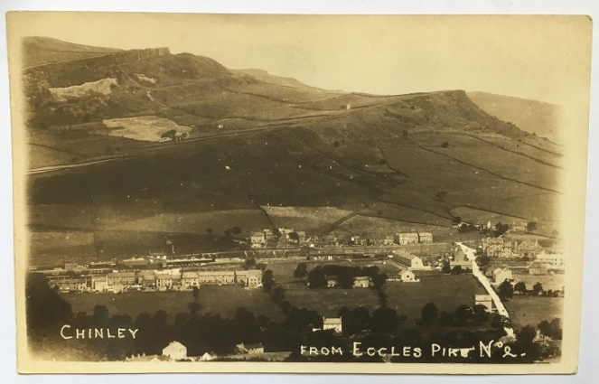
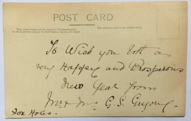
The first is titled “Chinley, from Eccles Pike No.2”, and shows exactly what it says.
The postcard hasn’t been posted, so there is no stamp or postmark, and was probably inserted with a letter, and the whole posted. The message on the back reads: “To wish you both a very happy and prosperous new year from Mr and Mrs G.S. Gregory, Fox Holes”. Foxholes is in an area of Chinley called Whitehough, which fits the postcard view.
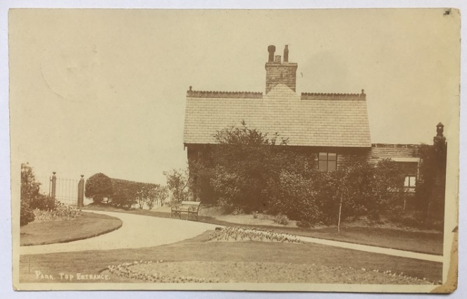
Next up is this view of the North Road entrance to Howard Park, or “Park. Top Entrance” as it is helpfully titled.
Park keeper’s cottage, Howard Park.
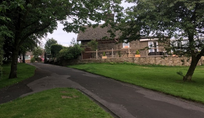
The building and gates are still there, as you can see in this modern view of the place.
Surprisingly, very little has changed in the 100 years.
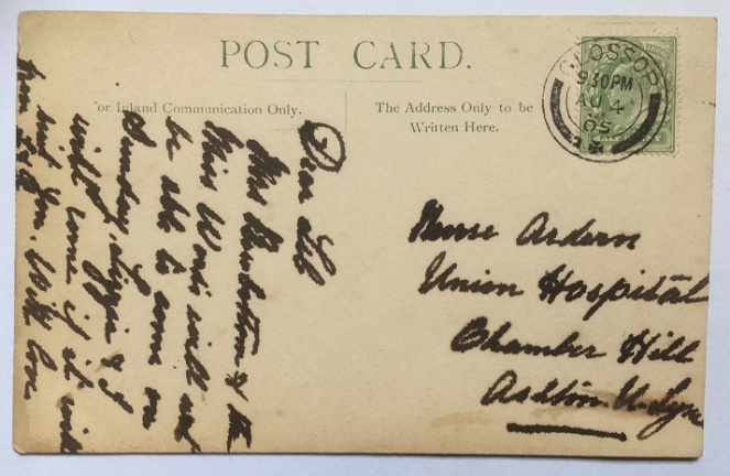
The back of the card, then.
Mrs Broadbottom (I think) and Miss Woods, helpfully written in thick pen and at a jaunty angle
It has been posted, and stamped “Glossop” (Glossop post office) and dated August 4th 1905, and was for the 9.30 post. The message reads “Dear Lib. Mrs Broadbottom (?) and Miss Woods will not be able to come on Sunday. Lizzie and I will come if it will suit you. With love from L & R.” One hopes that Lizzie and ‘I’ were a suitable replacement for what was clearly a comedy double act of Mrs Broadbottom and Miss Woods… but alas, we’ll never know. The address, however, is interesting:
Nurse Ardern, Union Hospital, Chamber Hill, Ashton Under Lyne
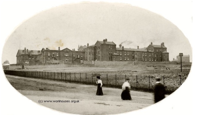
Frustratingly, I can’t find a Nurse Lib (Elizabeth?) Ardern in the 1901 or 1911 censuses, nor anywhere else I have looked (please feel free to have a look yourselves), but it is interesting. The Union Hospital is actually the Workhouse in Ashton, and the building is now part of Tameside General Hospital. Here is a view of the Hospital in 1905, the same date as the postcard – perhaps Nurse Ardern is one of the ladies in the photograph.
The Ashton Union Workhouse in 1905.
The above photograph was taken from a very informative website that gives the history of the Ashton Union Workhouse – go check it out here.
Now, the first of the interesting postcards, and one that contained a mystery! “Oooooooh” I hear you cry…
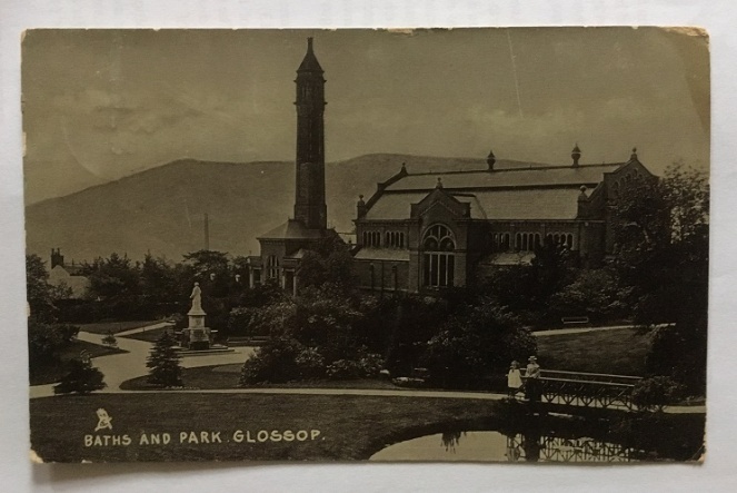
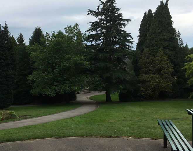
The view is of Howard Park again – this time the swimming baths and that end of the park. The view has not massively changed, as the lower photograph shows.
Howard Park and the swimming baths, chimney, and Wood’s monument, all built by the Wood family in the late 1880’s.Almost the same view, today. Too many trees to get the exact shot, but you can just make out the chimney, the white ornamental windows of the baths, and the base of the Wood’s statue.
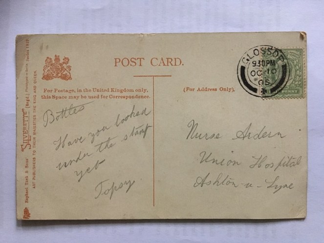
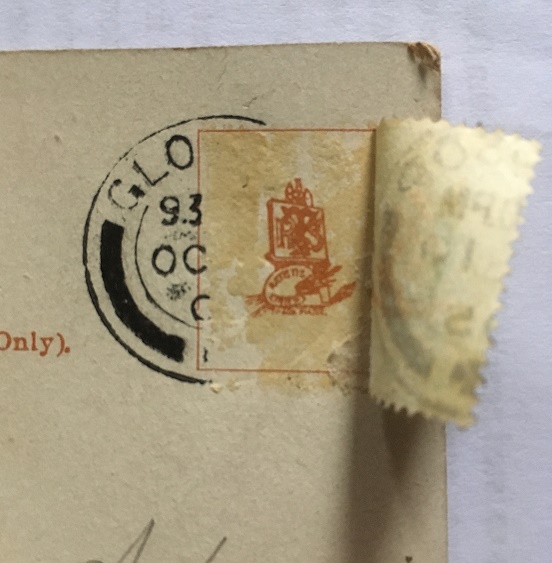
Now, the mystery. The card is once again addressed to Nurse Ardern at the Union Hospital. It is marked and dated Glossop, October 10th 1905, and stamped for the 9.30pm post. The inscription is simple: “Bottles. Have you looked under the stamp yet. Topsy”. It sounds like a letter from a PG Wodehouse novel (are Bottles and Topsy members of the Drones Club?). Bottles must be a pet name for Nurse Ardern, and Topsy? Who knows? A suitor? A brother? There is a familiarity about it that suggests either. But what’s this about a stamp? I looked, and no, the stamp had not been tampered with; Bottles had evidently not looked under it.
To Bottles, from Topsy… via Jeeves and Wooster.
With slight fear and trepidation, I made a cup of tea, and using the steam from the kettle, I steamed off the stamp. What was under it? A heart? A love note? A secret spy code? A crude drawing of some male genitalia? (the heady days of early Edwardian Britain saw society throw off the shackles of Victorian prudishness, so who knows?). Carefully, I peeled back the stamp, and this is what I saw:
Ladies and gentlemen, the comedy styling of Topsy.
It is just the card maker’s mark (Raphael Tuck and Sons), and nothing remotely interesting. Bugger! Two possibilities suggest themselves here:
Topsy has a particularly weak sense of humour, and the ‘joke’ is that there is nothing under the stamp (oh, my sides. Nurse, the screens… etc. that last being especially appropriate). No, even a badly drawn willy would have been funnier.
The postcard is referring to another postcard or letter, and Topsy is reminding Bottles to look under its stamp.
Either way, I was as disappointed as you probably are right now.
This last postcard is not disappointing, though, and should make up for the above.
We’ll start with the back – and a particularly interesting one it is.
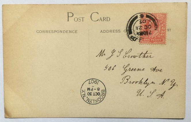
A letter to America all the way from Glossop.
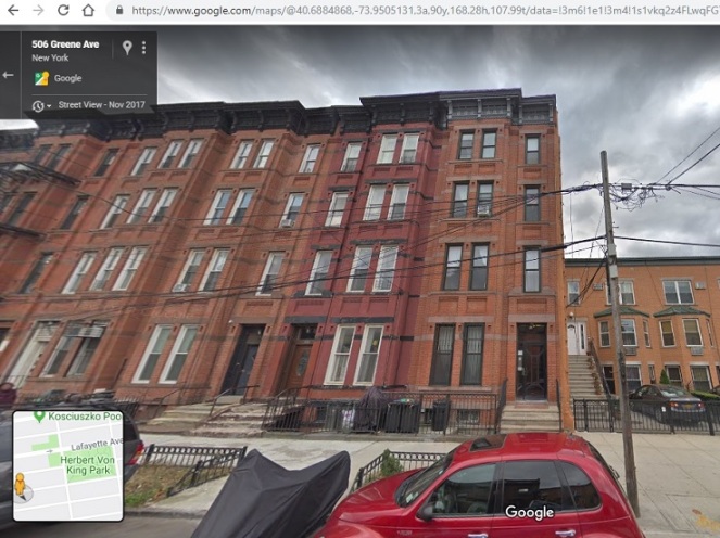
It is addressed to a Mr J S Crowther, 506 Greene Avenue, Brooklyn, New York, USA. It is postmarked Glossop, and dated Oct 21 1907, and stamped for the 7.30pm post. It is counterstamped ‘Brooklyn, NY’ with a date of October 30th 1907, and time stamped 8pm. This is presumably the time and date that the postcard landed in the USA – nine days to cross the Atlantic is quite impressive. There is nothing else written on the back, and the identity of Mr Crowther remains a mystery (as does his relationship with the postcard’s subject, as we shall see). His house in Brooklyn is still standing, though:
506 Greene Avenue, Brooklyn, New York, at the end of the row.
Right then, the subject of the postcard, and the reason I bought the quartet of postcards in the first place:
I love this sort of thing – when history and folklore collide.
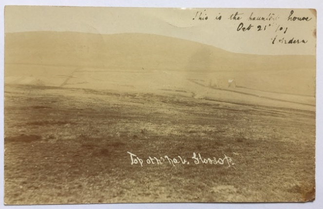
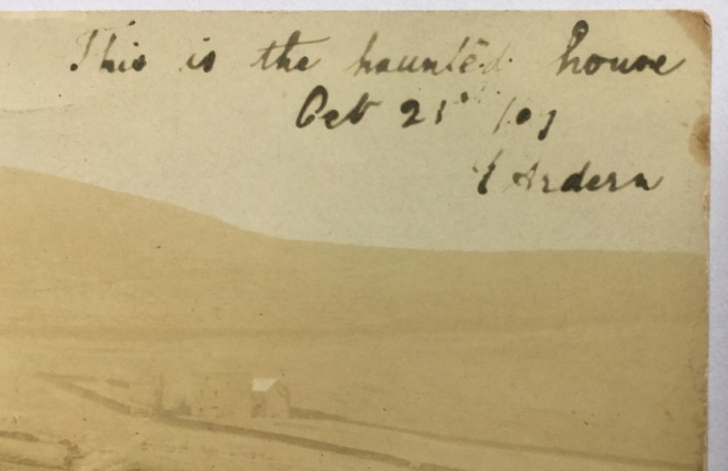
The subject is “Top oth’ Nab, Glossop”. Whitley Nab, of course, and you can indeed see the top in this quite atmospheric photograph. And in the mid ground, to the right, there is a building amidst a series of field walls. It is a good photograph anyway, but what drew me to it was the handwritten note at the top:
“This is the haunted house. Oct 21st ’07. T. Arden”
I do love a good spooky story.
I’m not a big believer in the supernatural, but I am a lover of folklore and of ghost stories, and I knew I had to have it!
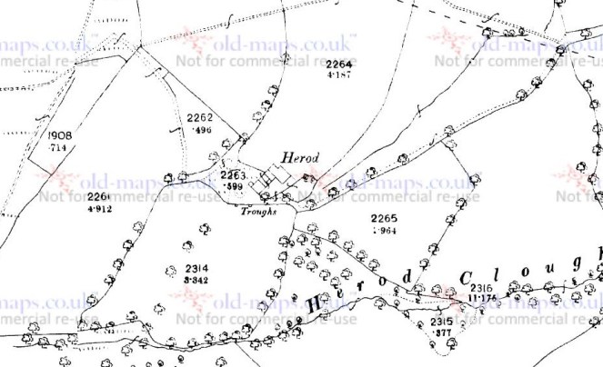
Well, where to start? I have looked at contemporary OS maps of the Nab, and am almost certain that the photograph is of Herod Farm; the location and the field boundaries all seem to make sense
If anyone wants to double check, please mail me if I’m incorrect
I find it interesting that Mr Crowther knew the area well enough that he didn’t need any further explanation of either the place, or the haunted house and its story. He must have been an emigre to the States from Glossop. The handwritten note is signed T. Arden – is this ‘Toppy’? And there is surely a relationship to the Nurse Arden, too – the coincidence of the name is too much. And how did they all end up in the America? Did Nurse Arden retire to the States? I would love to know the answers to these questions – any thoughts, anyone? But more importantly, what is the ghost story attached to Herod Farm? Does anyone know?
If you do, please let me know via email or twitter. Or, for that matter, any other ghost story or note of folklore you know about the Glossop area – I’ll happily take what I can! Just get in touch!
Anyway, I hope you enjoyed a wander round some old photographs. I’ll post an update if anything come from this post. Until then, I remain,
Here is the second installment of a terrific triptych of trivial twaddle.
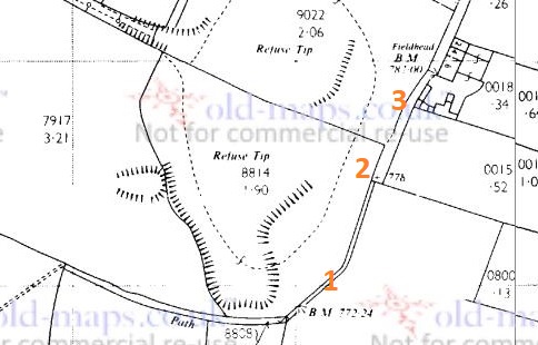
As previously mentioned, the path curves round to Fieldhead, and along the track, and here and there were bits of pottery and glass. Nothing earth-shattering or particularly old, but some interesting bits nonetheless. The question of ‘how did it get there?’ is a good one. In this case, it seems to have been a combination of nightsoiling, general littering in the past, and the presence of a rubbish dump. The quarry shown in the 1898 map below eventually goes out of use, and by the 1920’s has a new role as a miniature rifle range. Eventually, this too goes out of use, and the quarry is used as a refuse tip and filled in. Behold, the evolution of a quarry:
A Quarry in 1898.A Miniature Rifle Range in 1921.A Rubbish Dump in 1969.
It’s been a well used area, and it’s no surprise that there is bits of pottery all around – in particular the stretch from point 1 to point 2 on the above map. Incidentally, point 2 is the location of the gatepost bench mark in the last post. I’m also well aware of other bench marks in the immediate vicinity, only some of which I have looked for (it’s on my (very long) to-do list!). However, I did find two – those marked points 1 and 3 on the map:
BM No. 1 – 772.24 ft above sea level (or 769.7, according to the older OS maps). I think this is a more modern replacement for a missing older BM – the carving looks almost new.BM No.2 – 782.00ft above sea level (or 781.3, according to older maps). This one is on the side of Fieldhead Farm.
So then, the pottery/glass.
Left to right, top:
The base of a small cylindrical bottle, measuring 3cm across. Probably a sauce or relish bottle (Henderson’s perhaps), and Late Victorian/early 20th century in date.
Clay pipe stem – again, probably Late Victorian. It has some nice paring marks on it.
Our old friend, a fragment of a stoneware marmalade pot. It has a 9cm wide body, and the usual distinctive fluting on the side.
The neck and finish of a blue glass bottle. The finish looks like a ‘crown‘ type, and so is not particularly old, but the blue glass is interesting. I always thought that blue glass is associated with ‘poison’ or medicine bottles, but it seems I am mistaken.
Left to right, bottom:
the rectangular corner and base of a sauce bottle, possibly a Garton’s HP Sauce bottle, although there were dozens of similar bottles. Probably Late Victorian or Edwardian in date.
A tiny sherd of a glazed vessel with a raised decoration. Probably floral, although the sherd is to small to clearly see the motif. Almost certainly Victorian in date.
Sherds (glued together) of a fine Victorian teacup. It has a deep ring foot that measures 4cm in diameter, and is thin walled, which usually indicates expensive potter. The decoration is floral based, transfer printed, but seems to be quite fine
I really should draw these sometime, so that you can see what they are… I’ll save that for another blog post though.
That is just about it for this post… though Part 3 will be coming very soon, and that should be a very interesting post. Honestly.
It suddenly occurred to me that I hadn’t published any pottery or other bits and pieces for a while. Of course, whilst I may not have written anything, it doesn’t mean that I have stopped picking things up… nope, I have literal bags of the stuff, much to Mrs Hamnett’s annoyance.
So here goes with some interesting bits and pieces from all over Glossop.
These first sherds of pottery are from the back garden of the Prince of Wales pub, Milltown, Glossop. I have already blogged about the clay pipes from here in this post, but this is the pottery that goes with them.
Treasure from the Prince of Wales pub. I’m happy to return them, if they want them.
The same age, unsurprisingly, Mid to late Victorian, possibly early 20th Century. The stoneware (top right) is fairly bog standard, and probably comes from a ginger beer bottle or similar (which makes sense, given where we are). The blue on white pottery is difficult to date from small fragments, but it starts in the 1790’s, and carries on until… well, now! This wouldn’t be early stuff, and it’s been kicking around for a while in the soil, so Mid – Late Victorian it is. The top left is from a featheredge decorated dinner plate, measuring 24cm in circumference. Here is a good example of the type with some discussion. This style of pottery also starts 1790ish, but the type we see here is the same date as the others. It is commonly found with a ‘shell edge’, but this one has the impressions on the surface, but not the undulations. All very common, and very in keeping with the place being a pub in the busy Milltown area. I want to know what was being served on the plate – good hearty pub food of meat and veg, one assumes.
This next sherd is from Whitfield Recreation Ground. I found it a few years ago, after some heavy rain, just underneath the bench by the swings.
Unexpected find from Whitfield Rec.
Cream coloured stone ware, hard fired, and virtually indestructible, as I have mentioned elsewhere. This sherd is glazed inside and out, and comes from the bit that the joins the base to the side. This type of pottery was only normally used for ginger beer or milk in the late 19th and very early 20th Centuries, so we may assume that as the date. It’s a possible rare survival from a time before the recreation Ground was there (it opened in January 1903). I intend to do a future blog post about the ground, as it has a fascinating history.
This next lot is from Old Lane in Simmondley. This was the original road between Charlesworth and Glossop, and joined in the meeting of several roads at St James’s church, Whitfield (I have blogged about that meeting place before). I did a bit of a walk along the path as far as it goes (here, on my Twitter feed – and the next few photographs on from it), and it eventually fizzles out into fields. But along the way I picked up a few sherds.
Simmondly, Old Lane – the original road.
Top right is three sherds of cream ware, without decoration, and eminently undatable – probably Victorian, but ultimately these are destined for the midden in my garden. Top middle is a piece of thick slip glazed earthenware. This, I think, is 18th Century, so relatively early, and certainly earlier than the other sherds. It is glazed on the interior surface only, with the outer surface being washed with a red slip, so I think it is probably a cooking pot of some sort. Top left is a large stoneware storage jar of some form, or possibly a flagon like this. It is salt glazed on the inside, measures 14cm in diameter, has a chamfered edge around the base, and is almost certainly mid to late Victorian. Bottom right is a fine china open vessel – a saucer possibly – it is undecorated, and not enough remains to get a diameter. Bottom left is a broken fragment of a stoneware storage jar. It is salt glazed, and has an impressed decoration of a border of round blobs, which is a very common motif for this type of pottery.
Now, the good stuff!
There is a place, if you know where to look, in Manor Park, that produces all sorts of goodies. I think it is a late Victorian – Edwardian rubbish dump, or at least was one before being redeposited. Over the last few years, I have pulled some very interesting bits and pieces out of the soil, and I suspect there is plenty more, too.
First up, these two.
Unbroken glass bottles – something of a rarity.
The one on the right probably contained a hair oil or something (I don’t known why I know that, or even if it’s true, but I seem to recall reading it somewhere). Not that impressive, other than the fact that it still has the original label on it… except I can’t read the bloody thing! Frustrating.
The blue one on the left is lovely, though. Not a mark on it, and when I cleaned it off, I realised two things – firstly, there was a thick liquid inside it, and secondly, the seal was still good. I cleaned it really well, and gently opened up the bottle, and despite Mrs Hamnett daring me to taste it, I instead smelled it – faintly floral and clean. I think it’s rose scented oil for ladies to wear. A wonderful find.
The next two are really quite nice, too.
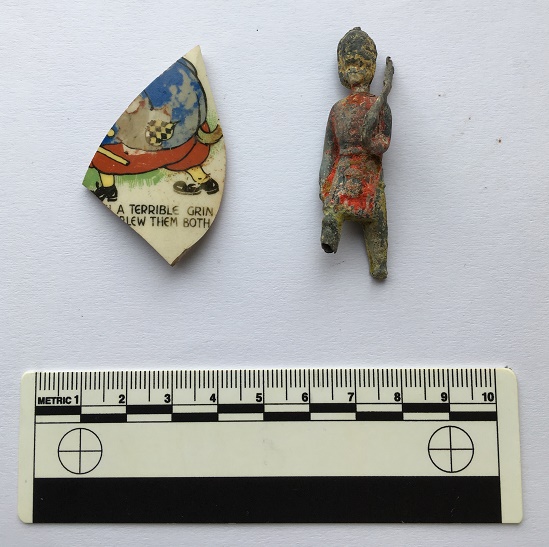
A taste of childhood – I love the personal side to archaeology.
On the left, a fragment of a child’s cup, presumably with a nursery rhyme round it. I have looked up the phrases “a terrible grin” and “blew them both”, but nothing pops up the internet. If anyone has an idea, please let me know, as I’d love to find out. The fat figure also seems to have a tail – a dog or wolf? I was thinking the Three Pigs as a possibility, with the wolf blowing down the houses, but I don’t remember him blowing two houses down…
On the right, one of my favourite finds. A hollow-cast toy soldier, a child’s prized possession, perhaps. A member of the Grenadier Guards, he has his rifle shouldered, and is marching, albeit with no feet, but at least he has the dignity of having paint. I love toy soldiers, and my own childhood was filled with Airfix plastic ones (I still have them… they await Master Hamnett’s sticky claws!). They were cheaply produced in their thousands, and are not uncommon in rubbish dumps, but I absolutely adore this figure. I have looked online, and although there are thousands like him, I can’t quite place him.
Amazing stuff, and if you buy me a drink, I’ll tell you where to look!
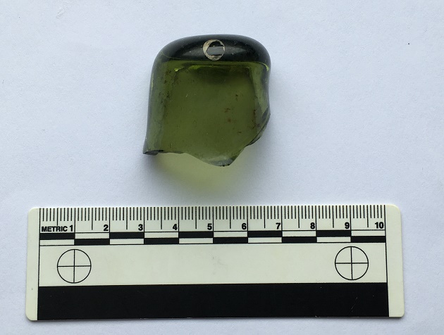
And to end with, a little foreign fun. During my France trip this summer, I found this crumbling out of a soil bank in a vineyard, on the road to the walled city of Carcassonne.
A surprise find, although not unexpected given where we were!
It’s the dimple from the bottom of a wine bottle – technically called a ‘punt’. This one is blown glass, which ages it – you can make out the tiny air bubbles when you hold it up to the light. I’m no expert, but I would say it is certainly 19th Century – and apparently the deeper the punt, the earlier the bottle – so perhaps earlier? Anyway, given where we were, I couldn’t very well leave it there, could I?
Hope you have enjoyed the pottery, and as always comments and questions are most welcome.
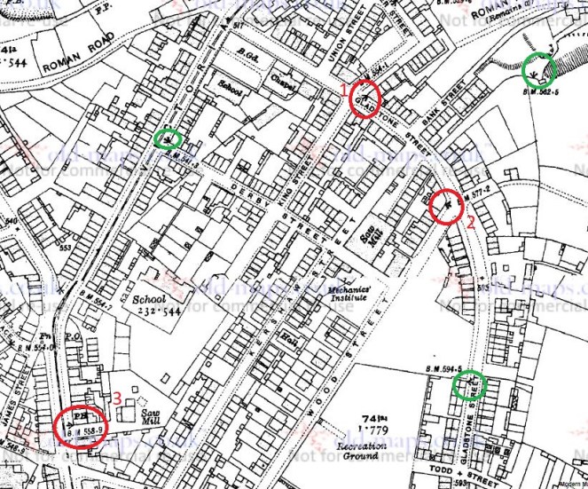
I realised recently that I still have quite a few Whitfield bench marks that I have not yet found, and that despite me having a bench mark obsession, I haven’t posted any for a long while. So here we are…
1921 1:2,500 OS map. The bench marks circled in red and numbered are photographed. Those circled in green are no longer there.
No 1 was extremely difficult to find at first – the building still stands, so it stands to reason that the mark would still be there. It is, but like the mark on the edge of Flatt Farm (No. 10, Here), the ground level had risen over the years – squint, and you can just about see the horizontal part of the mark. It took a while…
The mark is just about visible dead centre of the photo, just above the tarmac and just below the mortar. 554.1 ft above sea level.
No 2 was fairly easy to spot:
On the corner of a building/house – 577.2 ft above sea level.
No. 3 is on the corner of the Surrey Arms on Charlestown Road. Bizarrely, this is a pub in which I have never actually set foot. I fully intend to rectify this outrageous omission at some stage in the near future – if anyone fancies joining me for a swift half or three, let me know. The Surrey Arms is an interesting place, and has strong local connections. According to the earlier incarnation of me, it was built just before 1846 by a James Robinson, who also owned the Naptha works near the Beehive pub. This same James Robinson also built the Whitfield Brewery in 1849, and which was built on and used the waters from Whitfield Well. Hamnett then relates all the subsequent owners – Thomas Hampson in 1867, Samuel Clarkson in 1876, then later it became Walton’s Brewery with Adam Slater as the brewer who…
“made a special brew of ale for the late Lord Howard of Glossop to be consumed when the present Lord came of age. It was buried, and I have been told that when it was opened, it was stingo; only one pint for each person was allowed, and even that proved too much for some – it was true barley wine.”
Stingo (here and here) sounds like my kind of drink! The brewery eventually became a laundry, and was opened as such by Alderman B. Furniss in October 1895. Now that is a sad end.
No. 3 – The Surrey Arms. 558.9 ft above sea level.
Comparing the 1921 map with the 1968 1:2.500 map reveals that the No. 1 bench mark above has moved – probably because of the shift in ground level. Thus we have No 4:
It is now situated on the wall of a domestic house, but which was once The Sparrows pub, and more recently Flanagan’s. It stopped being a pub in about 2011, but I can find no more information about this pub, so would appreciate any thoughts.
No.4 – the ex Sparrows pub, or more recently Flannagan’s Irish themed bar… begorrah. Anyway, it is 531.89 ft above Dublin… I mean, sea level.
Right, that’s almost it. There are one or two more in this area that need checking out (when I get time…), so watch this space. And anytime anyone fancies a quick walk to find these things, give me a yell.
Evening all. The third blog post of June… see, I am trying.
Anyway, this one should (hopefully) provoke a bit of a response. I say hopefully because, dear and precious readers… I need a favour.
Some back story.
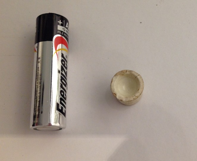
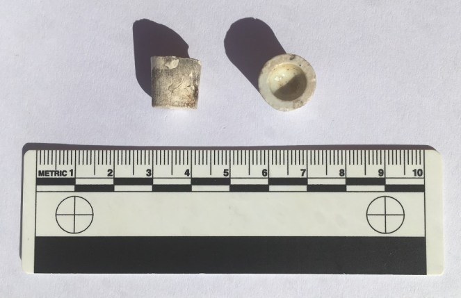
I received an email from the wonderful Sandra T. some months ago, asking whether I knew anything about this piece of pottery that she had found in Manor Park. She, like most of the people who read this blog, pick up random things they find interesting, which is to be commended (although, apparently, she keeps them in a clock… but let’s not judge).
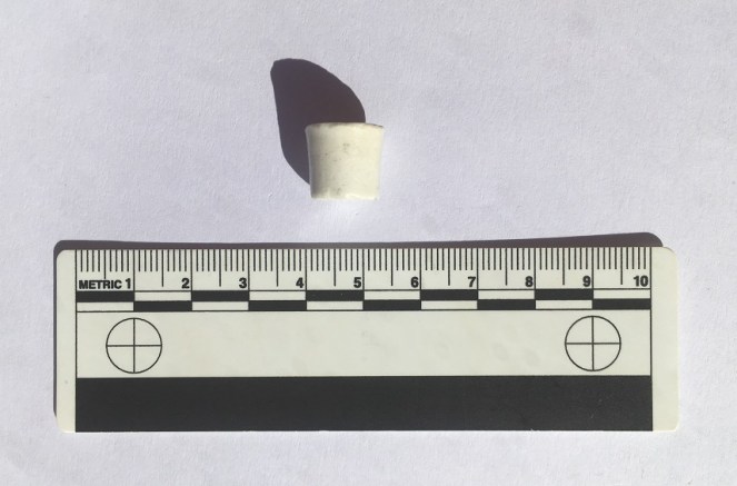
The mystery object – AA battery for scale. Copyright Sandra T.
Now, I had no idea what it was, but it rang a bell. a brief search through my ‘interesting things’ box, and lo!
Two more of these mystery objects.
So now we have three of these mystery objects. I found mine in an old dump near Broadbottom, which at the latest was 1910’s, but was generally earlier – say 1890’s – which at least gives us a time period to look at.
Interesting. I thought I’d do this post eventually, as someone out there might know what , when, and why.
Last month my new neighbour (hello Simon A.) partly demolished and rebuilt a wall on our property line, and in the process discovered that the whole wall sits on a bed of pottery and other domestic waste. This mountain of material will be the subject of a future post, especially as it makes a fairly coherent deposit, thus can tell us interesting things. The wall can only have been built post 1850-ish, and definitely before 1860, which gives us a clear date, too. Amongst the bits and pieces was this:
Another one… what are they?
So now we have four of them.
They are roughly conical, tapering to the base, measure between 10 and 12mm high, 13-14mm across the top, and roughly 11mm across the bottom. The bottom is flat, the top is hollow in a perfect hemisphere (I say top and bottom, but actually they might work either way up). Some are glazed all over, but one is only glazed on the interior of the hollow. This last point is important, and may hold the key to understanding what they are; it matters that only this bit is glazed, i.e. waterproof, not the rest of the object. Why? Also, they are clearly mass produced, and have a very specific role… but what?
I have two suggestions, both of which may work, but equally they are guesswork!
1) Kiln furniture. When you fire pots in a mass group, as they were being in the Victorian period, you need to keep the plates, etc. separate in the kiln, or the heat won’t circulate properly and you end up with poorly fired plates. These spacers were made in their millions, and were about the same size and shape. Though what they would be doing here in Glossop – not known for it pottery kilns – is anyone’s guess.
2) A way of selling medicine. The little hollow bit is glazed, but the exterior isn’t, so perhaps the medicine was stored in that bit, and scraped out when needed? Or it held a single pill that could be crushed in the hollow?
So over to you. Please, please comment and let me know what you think. The question is very simple. What on earth are they?
I’ll buy a drink for anyone who can tell me, with proof, what they are.


