Ok, so I think I’m onto something!
EDIT: No… no I’m not!
Alas, a mis-attribution in the Place-Names of Derbyshire has meant I have barked up the wrong tree! That’s not to say that there definitely isn’t a cross at Cross Cliffe, as suggested below, just that we can’t rely on the early place name evidence. Read the insightful comments by Neil Buckley below, which give what must surely be the correct reading of the text. My thanks to him for supplying the information, and working out the details. I’ll return to this in a later post as I think it is important, and in the meantime, feel free to re-read the blog post.
You know those moments when something that you have been staring at for years suddenly, and jarringly, comes into focus, and there is a slight tingle at the back of the neck. And then you dig a little deeper, and the tingle becomes a hunch, and then a possibility, and then a… you get the idea. Well, I’m there, and I’d like to share a discovery with you. This is still theoretical, even if the theory is based on good evidence, and I’m fairly certain that I can never prove it. But I’m getting ahead of myself.
Diving in and out of The Place-Names of Derbyshire to various previous blog posts (HERE and HERE) was a joy, and had me marvelling at both the sheer number of placenames recorded in the book, and the incredible depth of scholarship that accompanied their explanation. For those that have never read the book (and you should), it is a list of all the names of towns, villages, fields, roads, and streams in the area. However, on page 104, under the Glossop general heading, I came across a curious entry that got me thinking.

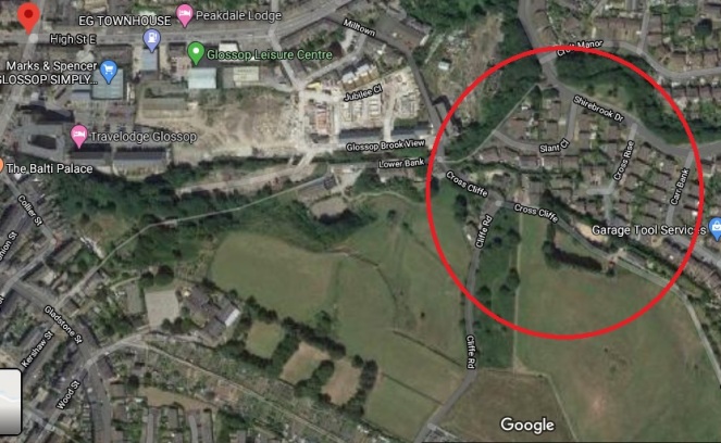
Specifically the entry for the road/area Cross Cliff, in Whitfield. For those of you who don’t now the area (and why not?), Cross Cliffe is this area, here:

Although now it gives its name to a road, it was once an area (circled in red above) which started at the bottom of Cliffe Road and lead down to Hurst Clough. The entry in the book reads:
Cross Cliff (6″), crucem de Cresclyf 1285 For.
It gives the earliest example of the name (crucem de Cresclyf), the date of this (1285), and the reference for this example (For = Forest Proceedings). So far, so perfectly ordinary.
So then, Cross Cliffe… and then a thought. “Hang on a minute… Crucem de Cresclyf?“
Now, I’ll admit it, my medieval Latin is about as good as my understanding of the language of the San people of Botswana – the one that uses clicks and other sounds. Or indeed, Klingon. I checked, and was – broadly – right (hurrah… personal victory, I’ll take that). I also checked with a real linguist (thank you AG), and was – broadly – backed up.
Crucem de Cresclyf: the cross of Cross Cliffe.
The cross? Which cross? Oooooh…
Bloody hell, thought I, and I went and bored Mrs Hamnett with this potential discovery. More research later, and I think I have just about convinced myself.
This, the first reference to Cross Cliffe, is taken from a 1285 document which gives a description of the boundary of land owned by a certain Thomas le Ragged. Thomas was a forester in the Peak Forest, and was given the lands by William Peverel, son of William the Conquerer and resident of the castle in Castleton. These lands included the hamlet of Whitfield. The descendants of Thomas le Ragged sold the Whitfield portion in 1330 to a John Foljambe, and from there it was portioned off and sold in lumps (Whitfield really does have an interesting history).
The description of the boundary of this land reads:
Required by the Foresters and others concerning the metes and bounds of the land of Thomas le Ragged of Fernley who claimed liberties, who say, that the metes and bounds of the said lands of the said Thomas begin at the Bridge of Welegh by the Royal Way to the (cross) to Crescliff, and from the said cross by certain caves (fovia) up to Routing-clought, and from Routing to Brownhegge, and up to the Waynstones, and from Waynstones descending to the Hocklow, and from Hocklow descending to the water of G’wit and by the water of G’wit ascending to the wood of Horworth.
Boundaries are based on and related to landscape features, and always incorporate immovable and visible objects, ones that can’t be disputed. Now, out of this, only a few points are identifiable. Whaley Bridge, Cross Cliffe, Hucklow, the River Goyt (G’wit), and possibly the Wain Stones on Bleaklow (although, I suspect that it may reference another ‘Wain Stones’, now lost to us). The other places I have not been able to identify (any help would be appreciated), and I’m not sure what to make of the caves – are these literal or figurative, and does a cave (fovia in the text) in the 14th century mean the same as it does now.
I digress, as the important bit here relates to Crosse Cliffe, or rather “crucem de Cresclyf” as it is in the orginal – the cross of Cross Cliffe. Not the bridge at Cross Cliffe, or the brook at Cross Cliffe, but the cross at Cross Cliffe. This is at a time when they didn’t use metaphors or flowery terms for place names – if it says the cross at Cross Cliffe, it meant the cross at Cross Cliffe. A physical, actual, stone cross. One that has been there long enough for everyone to know where it is, and use it as a point of reference. Which is very interesting. A previously unknown cross.
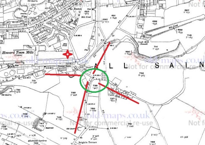
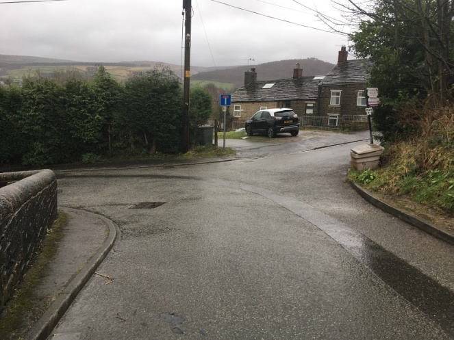
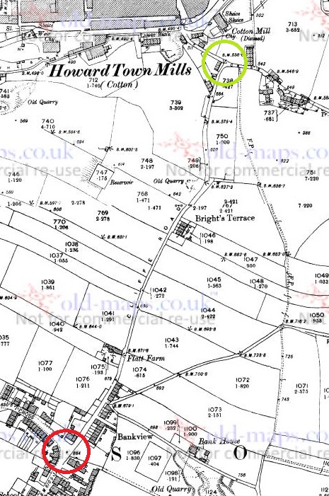
Its location also would support this. It would be situated on a crossroads – a favoured spot for crosses of this sort (Whitfield Cross for example). The present layout of the roads does not show this easily, but they have been changed, probably in the 18th century – I’ve got a post almost ready to go that explains all that, but here is a map to help:

The upcoming blog post will make a lot more sense of this area, but for now, roll with it!

Importantly, the cross would have stood at the border between the manors of Whitfield and Glossop – effectively Hurst Clough – and boundaries like this are exactly the sort of places that crosses are erected. Then there is the name Cross Cliffe. I had always, at the back of my mind, assumed that it meant the place where you crossed the cliff – perhaps a tall edge over Hurst Clough that no longer exists – or simply references the footbridge here. Well no. Delving further into the etymology of the name, it is derived from ‘Cliff‘ meaning a steep river bank, and ‘Cross‘ meaning, well, a cross. The name is literally ‘the steep river bank with a cross on it’, and crucem de Cresclyfe is then ‘the cross of the steep river bank with a cross on it‘. This a perfect description of that monster of a hill – it drops from 650ft at Bright’s Terrace to 500ft at the bridge over Hurst Clough – a 150ft drop over roughly 1000ft.
Placename evidence, coupled with a physical description, and a reading of the landscape and roads, seems fairly convincing. Well, to me anyway.
Now, there might a possibility that I am reading too much into this (‘surely not!’ groans everyone… I can hear you, you know! Don’t think I can’t). The ‘Cross of Cross Cliffe’ might refer to Whitfield Cross which would have been situated at the start of a small rise before the long steep slope down to Hurst Clough. If this is the case, then there is no need to look for another cross. However, I’m just not sure that this is the case. For one, the wording is too specific; “the cross of Cross Cliffe”, not just Cross Cliffe as an area – Whitfield Cross would surely have been too far away to be the cross described there, it is firmly in Whitfield, not Cross Cliffe.

Moreover, if Thomas’s land went to just the Whitfield Cross, then everything beyond that – including what is now Cross Cliff – would be outside of the described land. No, it makes sense his land went to the very edge of Whitfield, and the natural border of Hurst Clough, and it used a cross at the crossroads there as a marker.
What type of cross would it be, then? I would suggest that it was probably the same type as that which originally stood further up the same road at Whitfield – a 10th century Anglo-Saxon stone cross.
If this is correct, then where is the actual cross? 1000 years is a long time for a stone cross to survive. It may have been swept away in the iconoclasm of the Protestant Reformation of the Tudor period, or the iconoclasm that followed the Civil War, when crosses were routinely smashed – I read the other day of a Saxon cross that was broken up and used to fill a pothole in a road. However, the fact that Whitfield Cross survived these periods would suggest to me that Cross Cliffe would have likely survived, too. Perhaps we are looking at something more mundane; maybe it was accidentally broken, or worse, simply forgotten about as an important object, gradually falling into obscurity, to be lost in the hedgerows. Perhaps – and this really is a flight of fantasy – the stealing of the Whitfield Cross by the Cross Cliffe lads as a Mischief Night prank was not just a prank, and instead they were stealing a cross to replace theirs that was lost. It has never made sense that they would steal something so ridiculously large and heavy, so is this the answer? Well, probably not, but one can speculate wildly!
If anyone fancies joining me looking in hedgebacks and ditches for the original cross – after the current corona madness has subsided, obviously – then please drop me a line.
More soon – as I say, I have a whole post about the crossroads almost ready to go.
Until then, stay safe and stay inside, and take care of yourselves and each other.
And I remain, your humble servant,
RH

Robert, Perhaps Thomas le Ragged of Fernley was from Fernilee Hall just up the Goyt from Whaley Bridge. The perambulation might have followed the old Roman road from the bridge (King’s highway) to the old (broken) cross on Elnor Lane / Old Road junction then continued up hill across a small clough (could have been Routing) to Brownhill Farm then left to Waystones and back through Hockley to the Goyt. Its a long way to Glossop from there!
LikeLiked by 1 person
Thanks for the comment… excellent. Thomas le Ragged was indeed of Fernilee Hall, so what you says make sense. I did spend some time plotting out the place names in the Whaley Bridge area, but couldn’t get anything to fit, and I also struggled to make sense of the distance, too. But… we know le Ragged had Whitfield, or at least he and Matilda de Whitfield had it, so it would in theory take it to the border with Glossop (Hurst Clough). And we also have a Brown Hill Farm in Whitfield. Although perhaps there is a clue in her name – did she have Whitfield, and he had Whaley Bridge? And the place name evidence you give is convincing. Bugger!
I would like to plot both interpretations out on a map, to see which forms a coherent area. But right now, I’m erring on the side of your interpretation. Which means that the English Place Name Society are incorrect… you can tell them! RH
LikeLiked by 1 person
After a rethink I’m more convinced now its a perambulation around the Fernilee estate. From the bridge up to the broken cross (Gelling & Cole 2014, 153; say a cliffe/clyf can be on rising ground not necessarily on a cliff) it wasn’t on the Roman road until it got to the cross but it was certainly on the Kings Highway. 1285 is the earliest date I’ve heard of for a bridge at Whaley so that’s interesting. The Roman road would actually have made the site of the Crescliff a cross roads its believed to have gone down to a ford near the dam, or did it go to a bridge as well? I’m willing to believe that the Roman’s might have had a bridge there first, they had plenty of raw material from the gap they cut in Wainstones. Anyway the perambulation then goes up the Roman road/King’s Highway and crosses what was (likely to have been) Routing Clough at SK02202 78833. Brownhegge (Brown Hedge) probably started near Wythen Lache, Wainstones looks down on Brown Hill (OS map 1st series) but it wasn’t very prominent, further up the valley Bunsal Cob (SK01856 75715) is more likely to have been Hocklow at that time. A small clough below it leads to the Goyt. Then follow the Goyt down to the bridge through Shallcross Wood previously Horworth Wood perhaps, but it could have been furhter down nearer the ford (OE Warth) perhaps. I wonder if the caves are still there, probably quarried out long ago. Is the original text on line anywhere? Also I understand Ragged doesn’t pertain to his clothing, a “ragged (nobbly) staff” was used in heraldry and might have been on his coat of arms. I enjoyed that, thank for the lead! Neil
LikeLiked by 1 person
Isn’t this the physical remains… Up the hill?Â
Sent from Yahoo Mail on Android
LikeLiked by 1 person
Neil. Yes, I agree with your reading of the perambulation. It certainly makes much more sense than coming from Whaley Bridge to (my) Cross Cliffe in a single bound. Also, the place name evidence fits so much better around Fernilee, and following it on the map it becomes clear. So then, it seems Thomas held Fernilee, Mathilda de Whitfield held Whitfield, which makes sense.
My understanding too is that Ragged is indeed the ‘ragged staff’, although I like to picture him as slightly mad forester, stalking poachers in ragged clothing. Interestingly, Matthew Champion (of Medieval Graffiti fame) suggests that the ragged staff might also be a symbol for a saint, perhaps St Christopher (I recommend the book, but the website explains a lot, too – http://www.medieval-graffiti.co.uk/page100.html). As for the original text – no photograph, but there is a transcription of the whole Forest Roll here: https://studylib.net/doc/7596720 I can’t vouch for the transcription, but it looks legitimate. There are other mentions to it, also, dotted around. Thanks for clarifying. RH
LikeLiked by 1 person
Robert, thank you for the link to the Forest Roll transcription .I see the original is on line but not out of copyright so can’t be read in full. A little more on Thomas le Ragged that I noticed when searching, did you know he was “of Chisworth”. This could be a different generation of course but his name came up here: https://books.google.co.uk/books?id=NvAMAQAAIAAJ&pg=PA413&lpg=PA413&dq=ragged+of+chisworth&source=bl&ots=sgzSxLQxnD&sig=ACfU3U1GUAfbFJz28lh0db50SREfjvDIuQ&hl=en&sa=X&ved=2ahUKEwiVua3wmNTpAhV7aRUIHR2cAFwQ6AEwAHoECAcQAQ#v=onepage&q=ragged%20of%20chisworth&f=false . Keep up the good work.
LikeLiked by 1 person