If you follow me on Twitter, you might know that I recently gave a talk to the Macclesfield LIT Festival with the wonderful Elizabeth Garner. It was billed as an evening of folklore and folk belief, with Liz reading folk tales from her new book, and me discussing all manner of magical things designed to protect against witchcraft. Well, it was a great event (thanks to all involved), and I think quite successful judging from the reactions.
Well, if you missed the live event (streamed from my spare room), it’s now on Youtube. We explore some interesting local archaeology, look at witchcraft and counter-witchcraft measures, and hear some great stories. Enjoy (video starts at 4 minutes).
Please also feel free to follow me on Twitter – I tweet fairly frequently about local, and occasionally not so local, interesting archaeology/history. And there is absolutely no politics, guaranteed. @roberthamnett if you want to follow me.
What ho! Greetings one and all. Come on in and take a seat. Can I get anyone a drink?
Today, I finally finish a blog post that was started 2 years ago. Not for any particular reason, it’s just that some posts are more urgent, and others seem to, well, ferment… if that’s the word I’m searching for. If it isn’t, it’ll have to do.
So, I was reading a little bit about the history of St James’ church, the parish church of Whitfield. And a splendid one it is too. Living in Whitfield, I have a strong attachment to the church, not least of which I can see its spire from my bedroom window, but also Mrs Hamnett and I were married there. And by a spooky coincidence my namesake and pseudonym – the original Robert Hamnett – was a member of the congregation and is in fact buried in the graveyard there, something I didn’t know at the time of my nuptials.
The church was built in 1845 (and consecrated in 1846), on land that was bought from the estate of Thomas Dearnley, of Tintwistle, a schoolmaster who had died in 1842, at a price of £110. This land – Lower Meadow as it was originally called – was described in the deeds as being bounded by “Holly Cross Lane and Wall Sitch“. Holly Cross Lane – now known as Hollin Cross Lane – makes sense, but Wall Sitch? Well, it is an unusual name, and, given my love of placenames and their meanings, I went digging. According to the paper “Semantic Structure of Lexical Fields” by David Kronenfeld and Gabriella Rundblad (2003:29) (no, I don’t understand what it means either… something to do with words, apparently) Sitch is “commonly used for (very) small streams, especially those flowing through flatland, and can be used for both natural and artificial watercourses”. It is derived from the Old Norse ‘Sik’, via Old English ‘Sic’, both meaning a marsh and/or a watercourse. It is not uncommon in the North West, and in particular those areas that fell under Dane Law (that is the area controlled by the Vikings, and subject to their laws). Glossopdale and surrounds is right on the border between Anglo-Saxon Mercia and Viking controlled Danelaw, so it is not surprising that we have a few Norse place names. Indeed, a little further up the valley, off Monk’s Road, is a ‘Sitch Farm’, which sits just above a small brook.
So then, I went looking for the Wall Sitch – the small watercourse by the wall – and do you know what? I think I found it, despite it being very hidden.
Here’s a map of the area, so we can see what’s what.
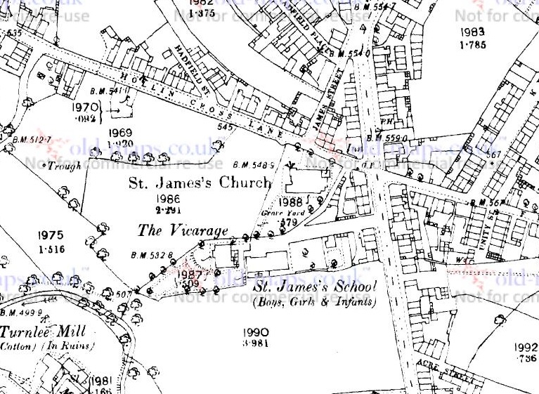
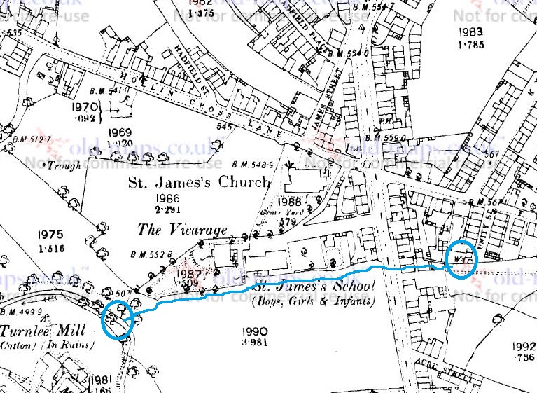
The 1880 1:2500 OS map. The church is central, with Hollin Cross Lane above it.
I first thought it might be roughly parallel to Hollin Cross Lane, so I looked at the south side of the churchyard. Nope… nothing on the ground, or on the maps. “But wait… hang on a moment!” thought I. The vicarage and St James’ school (the original one, not the newer one further up Pikes Lane) must have been built on church land too, and at the same time as the church, so I looked at the boundary below them. Well, it is immediately obvious there is no stream visible as such, but there is something very odd about the shape of the boundary – you can see it in the map above above the words ‘St James’s School’. Generally, when someone draws a boundary, it is straight, unless of course something stops it from being straight… and this one is a meandering shape. This type of ‘landscape archaeology’ can really help in identifying older or lost features, and I think it does here – the boundary has been determined by the course of the stream. So I went looking down Ashton Street (a road not yet built in 1880) to see what, if anything, I could see. Here it is on the 1921 map:
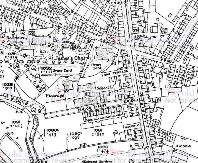
Ashton Street below the school. The meandering boundary has been straightened here.
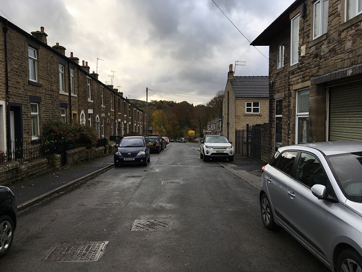
And here it is in real life:
Ashton Street, looking west. You an see the slope of the road as it goes down to Long Clough Brook.
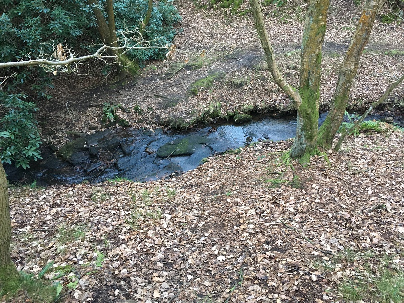
Well, disappointingly, there was not a lot to see. The school has been demolished – Master Hamnett now attends the successor school, built in the early 1920’s – and houses now occupy the site, although there are traces here and there. However, halfway down I heard a noise. Water! Below a drain cover in the road water was rushing, and then again farther down the hill toward the Long Clough Brook, below another drain cover.
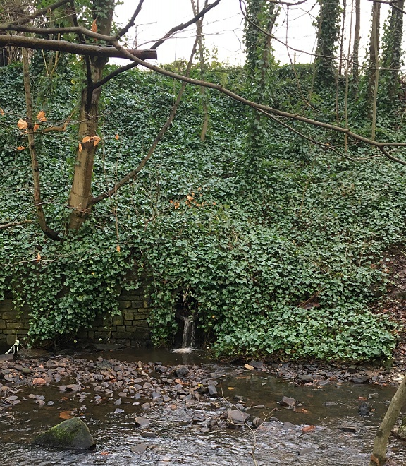
This has to be it. I wondered if there was an outfall into the brook, surely the final destination for the sitch? And lo!
Wall Sitch outfall into Long Clough Brook.
Excellent! I love detective work, and it’s exciting when a hunch pays off. This is exactly the sort of thing that I started the blog for. So there is the outfall, but it got me thinking… where is the start of Wall Sitch? Well, tracing the meandering line of the sitch back, and under Charlestown Road, it seems to stem from a well (marked with a ‘W‘ on the map below) at the end of Unity Street. Now, by coincidence this well was the subject of a previous blog post – check it out here – and although it is no longer there, clearly the water from what would have been a spring head, similar to Whitfield Well and many others in the area, is still running.
The probable route of Wall Sitch – from the well on the right, under Charlestown Road and along what is now Ashton Street, to the outfall into Long Clough Brook circled on the left
Makes you wonder what else is lurking, hidden in the ground, or in maps.
That’s all for now, but more soon – I have some posts that are 3/4 finished, so I should be able to get these published fairly rapidly. So, until next time, and as we head into another lockdown, take care of yourselves and each other.
Mrs Hamnett complains that going for a walk with me is difficult – apparently I’m like a dog, running about looking for things. We’ll be walking along, talking, and I’ll disappear into a hedgeback or ditch, pulling out a bit of pot or stone, and leaving her talking to herself. Master Hamnett has now adopted the custom, and he regularly finds bits of pottery that he hands to me, looking very pleased with himself. This leaves small piles of pottery around the place, which get cleaned and put into bags with the intention of sharing them with you, gentle reader. And as you know, intention and actually doing are two widely different things – I’m going to have “well, I was going to, but what happened was…” carved on my headstone.
Well, not today. Today I do! I am seizing the day, grasping the nettle, taking the bull by the horns, striking whilst the iron is hot, and a host of other tired cliches. Today is a pot and other bits day… but first a cup of tea.
Right, that’s better! Off we go.
A few months ago I posted this, a toy soldier fund by Master Hamnett at the Spencer Masonic Hall/Sunday School at the top of Whitfield Avenue. Well, we went back recently, and blow me… we found some more.
Bizarre, and slightly creepy. I love these things.
Bizarre. I can only think that someone was using this as a place to play with their soldiers, and then lost them. As I said before, these were my childhood (I still have them). From right to left: a 1:32 scale Airfix British Commando (mid 1970’s to, well, now in date). Then we have a copy of a 1:32 scale Airfix British 8th Army Desert Rat; it says ‘Made in Hong Kong’ on the bottom, which dates it to pre-1997, when Hong Kong became Chinese. Then there is the lower half of Marvel’s Iron Man, which has the date 2005 on the base. I suppose these are technically ‘rubbish’, being deposited only in the last few years, but I reasoned that if I picked up a Victorian child’s marble, then why not these too. If you recognise them, and want them back, give me a message. Above the toys is a squashed thimble, again probably of relatively recent vintage.
Some other bits and pieces found in the grounds:
Other bits and pieces from the grounds of the Masonic Hall
From the top down, then. Randomly, fragments of a clay pigeon – which begs more questions than it answers. This is definitely rubbish, and will be going straight in the bin, but I thought I’d post it in the interests of completion. Below that, a copper roofing nail – Victorian or early 20th Century, and clearly from the roof of the building, dropped during a re-roofing, perhaps – I love these things, and have blogged about them previously. Below that, an ‘L-Headed’ machine cut wrought iron nail – probably used for flooring, and perhaps Victorian.
Continuing the revisit of that post, here is some more pottery from the area:
A small haul, and nothing too spectacular.
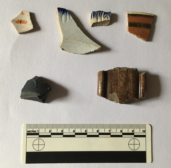
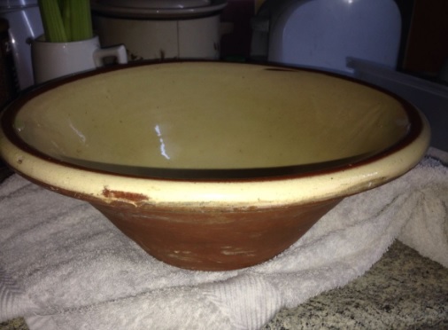
Some odds and ends. Top row, from left, then: the bottom of a jar of some sort – earthernware, and with the letters ‘A’ and ‘D’ impressed on the bottom. It’s possible this is ‘MARMALADE’, as it’s the right type of jar, but I don’t think it’s an ‘L’ before the letters. ‘M[AD]E IN ENGLAND’, perhaps? Next a saucer, then a black glazed open vessel, and then the chunky handle of a jug or similar, but certainly not a tea cup, the handles of which were delicate in the Victorian period, which is when all of this pottery dates from. Bottom row from left: a creamware jug, and from the curve of the sherd, this the rim of the spout; early Victorian, at a guess. Next, the base of an open bowl, then the interior shoulder of soup bowl, the base of a plate (complete with knife mark scratched into the glaze), and then the shoulder and neck of a small saltglazed stoneware bottle. Originally, it looked like this one, probably an ink bottle, and which has roughly the same dimensions:
A stoneware bottle which, incidentally, I found in a Victorian tip in Broadbottom.
Next up, we have some interesting new bits from below Lean Town, picked up whilst I was waiting for Master Hamnett to finish at the excellent Inside Out Forest School in Gnat Hole Woods, not too far from Nat Nutter, as it happens.
Some very nice bits here. Oi! You there! Not you, you! Stop sighing… I can hear you muttering under your breath you know, it is not a “pile of old crap”. Honestly, the nerve of some people.
Top row: sherd of earthernware with painted orange flowers, which I thought looked nice. Then we have two different shell-edge ware vessels decorated a blue scalloped edge. The one on the right is the earlier, being made between 1780 and 1810, whilst the sherd on the left was made between 1800 and 1830. Then a sherd of annular or banded ware – the decoration looks very 1950’s to modern, but this stuff – usually in blue (there is an example below) – actually starts being made in the 1790’s. This one is Victorian. Second row on the left, a base sherd from a basalt stone ware bowl, roughly 1780-1830-ish, It’s a lovely example, very thin walled and with the bottom of an acanthus leaf or something coming up from the bottom. They were heavily influenced by Classical pottery, and it looks Roman orAncient Greek from a distance, but was in fact made by Josiah Wedgewood’s factory in Staffordshire. Then we have the handle to a monstrous stone ware jug or storage jar, and although it looks almost medieval, it probably came from a Victorian water jug or something. Following on from the mega post about Lean Town I’ll add this lot to the bag of bits, and I’m sure more will wash out over winter.
Moving on, we have a rim sherd of a pancheon and another sherd picked up from a path that leads from Bankswood Park in Hadfield to Mouselow.
Big chunky rim – I love these things.
The smaller sherd is a from a cup or bowl with blue horizontal stripes on a white background – more annular or banded ware from the Victorian period. The larger sherd is part of the rim from a large pancheon – essentially a large mixing bowl that most kitchens in the 18th and 19th centuries would have had (I talked about them here). What looks like a yellow glaze is actually a clear glaze over a white slip – you can just about see it on the edges. Below is what it would have looked like, although this example is later and much smaller, the rim sherd suggesting a vessel 70+ cm in diameter.
A Victorian pancheon yesterday.
The path crosses another track which originally ran from Cemetery Road to Shaw, along what would become Shaw Lane, before it was bisected by the building of the railway.
The lane actually skirts the edge of the Iron Age hillfort, and parts of it are preserved in footpaths and tracks, but I don’t want to get into this here, as it is a topic of another post. However, here are some photos of Shaw Lane as it crosses Mouse Low – the above pot fragment was found at this junction with the footpath, marked in red on the map.
Overgrown and unused, this was Shaw Lane looking South West. In case you can’t see it, it’s the sunken road bit to the left of the tree in the centre of the photo. Apologies for the darkness.
Shaw Lane looking North East. I need to explore this track – it looks so appealing!
Next we have a small collection of bits from the bottom of Cross Cliffe, along the road edge and by the track there. Nothing earth shattering, but a good selection.
A good selection of bits, and a clay pipe!
Top row, from the left: a fairly substantial transfer printed soup bowl roughly 20cm in diameter; the base to a ceramic marmalade or preserve jar of about 10cm in diameter; a stoneware sherd from a storage jar of about 16cm in diameter. The thing that looks like a mint is either a button or the end to a hat pin, and is made from alabaster. Next row: sherd from a large jug or similar, with large hand-painted flowers on the exterior; rim of a stone ware ginger ale or lemonade bottle, with the very characteristic brown salt glazed surface; a fragment of willow pattern transfer-printed plate, and a stem of a clay pipe with, alas, no maker’s name, but some nice paring marks.
Ok, so this is turning into a far larger post than I had anticipated, and I’m going to draw a line under it for now – nobody, not even you, you wonderful and attentive people, wants to read a wall of text. Expect Part II either next time, or sometime in the future
So, to end with, for now at least, two superb examples of Glossop bricks, a gift from our equally superb neighbours (hello Helen and Sarah).
I love these things – simple and mundane, and literally stamped with their place of origin.
I don’t know a great deal about these bricks, but a future blog post might delve deeper. The company was based at Mouselow, with the clay extracted from nearby. It seems to have been founded in the 1920’s by a John Greenwood, and continued until the 1980’s. Somewhere in the garden I also have Glossop brick with both Greenwood’s name and Glossop printed on it – perhaps this was an earlier brick? There is some information on this website, but I can definitely feel a blog post coming on.
Bricks are so mundane, and yet so fascinating, and useful archaeological dating material too. And once they begin stamping the maker’s name into the frog (the dipped bit in the middle) – sometime around the mid-Victorian period – they become individual, too. I stumbled across this website the other day – a gigantic collection of photographs of bricks with the names showing, and all alphabetised; this is what the internet excels at, the dissemination of knowledge that would otherwise be inaccessible, and it is truly magnificent. I look upon these bricks with envy, but silent and certain in the knowledge of one single fact: were I to start a ‘brick collection’ Mrs Hamnett would forcibly and violently eject me from the marital home. I would be a single and homeless (and brickless) man again before you could say “now wait, dash it all”. No, she puts up with quite enough as it is, so this injustice and pain is a weight I must bear with quiet resignation. However, if someone does have a spare shed, you can contact me in the usual way…
Right, that’s your lot! And it is a lot… too much, in fact! The question of “what am I going to with it all” never really occurs to me, and beyond the obvious “put it on the blog” I have no idea. I’m going to have a clearout soon, and get rid of the more boring bits and pieces – the plain white china, etc. and bury them somewhere for future archaeologists to ponder over. In fact, I was going to do it last week, but what happened was…
More soon, but until then, take care of yourselves and each other.
Good evening gentle readers. I say good evening, for this is when I am writing, but it could be anytime you are reading this. And indeed anyplace… which worries me slightly. Anyway, moving swiftly on.
Recently, I posted a hotch-potch, pickle-type post, that looked at the cheese press I found that was being used to fill up a hole in a trackway. Well, some interesting developments have, well… er… developed.
Firstly, it seems that the whole cheese press is present, which is excellent news. But alas it is broken into two pieces, which isn’t such excellent news. Still, the fact that it survives at all is pretty impressive. Secondly, and even more impressive, I think I might have identified to whom it belonged, which is amazing if true. Please note the use of the phrases “I think” and “if true“… I’ll leave it to you to decide.
Firstly, then, the press.
It’s complete, as in it’s all there, although as you can see it is sadly broken across the middle. It measures 94 x 43 cm, and about 10cm deep, so it’s not huge – and these things do come in huge sizes. I had a poke around mini excavation, just to reveal the edges, and to assess how much was there, but I didn’t want to dig too far – it is filling a large hole in a track after all.
Nice to see the whole thing – you can just make out the corresponding beam hole on the right.
Master Hamnett helped reveal the press, of course… any excuse to get dirty.
Master Hamnett ‘helping’ with the excavation and the photographs
It’s fantastic, and I honestly think that this needs to be removed from the road and put on display somewhere; it is a wonderful piece of evidence for life in 18th century rural Whitfield that deserves to be treated better than it currently is.
Right then, so who owned it? Well, I was reading through a collection of Glossop-based 17th and 18th Century wills the other evening.
Before we move on, perhaps we should examine that statement. I have just read it back, and the thought occurs to me… mine is perhaps not what you might call a ‘normal’ life. I mean, here I am, on a Friday night, reading 300 year old wills, and getting excited over some new bits of pottery I found yesterday. Sometimes it’s good to take stock of one’s life… and other times it’s good to simply leave one’s livestock alone.
Anyway, back to the wills. They have been digitised as part of the North West Derbyshire Sources project which is a truly remarkable source for local history and genealogy in this area, and filled with all kinds of information – if you don’t know the website, please do have look. The will that caught my eye was that of John Cowper (Cooper) of Whitfield, and dated 1750. The actual will is fairly bog standard, but is genuinely fascinating as it contains, in a nutshell, the contents of an average well-to-do household. Cooper was someone who we would now perceive as comfortably middle-class, but was then known as a yeoman farmer; someone who owns a small amount of land freehold (paying no rent), and who earns his living from it. I won’t reproduce the full preamble here as it is a wall of text – but it well worth a read (the full transcription is to be found here – it’s alphabetised, so look for John Cooper of 1749/50). However, the contents of the house is as follows:
Item
Value (£ s d)
Imp/ Purse & Apparell
7 0 0
A large Bible & Clock
3 0 0
Two cows
6 0 0
A cupboard & table
0 15 0
Two coach chairs 15s 12 chairs 10s
1 5 0
One Fire Iron tongs, 3 bread Irons Fire Shovel & Brigg
0 15 0
One little Fire Iron, smoothing Iron Clever two Hand hooks & Spittle one frying pan
0 3 0
One Warming Pan a skellet a brass pan a brass pott & saucepan one Lead, Lead weight & Mustard Ball
0 15 0
8 Pewter Dishes one Tankard 1 Cup 4 porringers, Spoons
0 14 0
Books & Linnen Meal Cheese & Bacon
4 17 0
One Bedsted & Bedding & a little Cupboard ith Parlour
1 8 0
One Bedsted & bedding in the long Chamber
2 10 0
One Press
1 10 0
A Long table & one little oval table ith parlor Chamber
0 17 0
One bed & bedding ith Chamber over House
1 5 0
One meal ark 8s one Chest 10s one little chest 6s one Desk 5s one Box 1s ith same Chamber
1 10 0
One Cheese Tubb 5s one kimlin 2s Cheese fatts & other wooden ware 5s & one cheese press 3s
0 15 0
One little Ark in the Porch 1s 2 Iron potts 2s a Glass case two fall tables 2s a kneading trough 1s
0 6 0
One Shovel Mattock & Bill & Dock fork & Ax
0 3 0
One Stock of Bees at Thomas Cowpers
0 10 0
Huslement
0 5 0
46 3 0
In Bills
88 2 0
134 5 0
The items listed, then, are those that are considered of value in the mid 18th century, and if you look, it’s largely the things that we would take for granted. Imagine someone doing this to your house – have a look around. Would they mention your pots and pans? Or your fire irons (assuming you have a fire – everyone in the 18th century certainly would have). Or your bed linen? Or your cheese and bacon? It’s bizarre, yet it also makes sense. There were not many frivolities then; would bacon count as a frivolity if you had raised the pig, killed it, salted it and stored it? No, it would be a resource that you had earned. Your iPad would be listed, but Cowper had a clock (along with a large Bible, valued at £3 [£350 in modern money]. Your car would be listed, but Cowper had two cows and a hive of bees valued at £6s10 (£758.35 in modern money). Your all-singing, all-dancing, ride-on, lawn mower might be listed, but Cowper had “One Shovel Mattock & Bill & Dock fork & Ax” valued at three shillings (£17.50).
Some of the items listed needed a little further exploration. For example, the ‘Mustard Ball‘ valued with the rest of the pots and pans from the kitchen threw me. But it turns out that they were literally balls of powdered mustard.
Traditional mustard balls. Image stolen from the Tewkesbury Mustard Company website – there is a link to the site below… fascinating stuff.
The seeds were powdered, and mixed with some form of binder – wine, vinegar, honey or raisins, for example – and when needed, slices were taken and soaked in a liquid to soften them (in vinegar, or verjuice, for example – the sour juice of crab apples), and added to food. They are still made, as they were 700 years ago, by a company in Tewkesbury (the Tewkesbury Mustard Company) who make the best, apparently (and I have no reason to doubt that). Thanks also to this fascinating blog about historical food for the information.
The above mentioned “Dock Fork” was also not something I had encountered before; a little research brought forth this:
Dock fork, from the easyliveauction.com website – this one sold for £25… a bit more than the £17.50 it was valued at, with other implement, in 1750.
As anyone who has ever weeded a garden will know that docks are difficult buggers to remove, and yet are brittle, breaking and leaving root fragments that will flourish into full bushes of weeds in weeks. A problem to which the answer is a dock fork, that allows you to lift the whole plant without breaking it. Obviously.
The important bit for our purposes here are those items listed that are used in cheese making, and specifically the cheese press. As you have seen, it’s not a small item, nor is it something that everyone would own – it’s a specialist implement used on much more than a domestic scale. It, and the other cheesemaking equipment mentioned in the inventory, indicate the relatively large-scale making of cheese to be sold, and perhaps supplying everyone in the local area. As perhaps only a single farm in each area would have one, I would suggest that the one mentioned in John Cowper’s will is the one I discovered a while back, and which is now filling a hole in the track. I realise that it is impossible to prove, after all the stone has no provenance, nor do we have an address for John Cowper other than Whitfield. But Whitfield as a settlement was concentrated along Cliffe Road and Hague Street – the old road from Hayfield to (Old) Glossop, and largely around The Beehive (it arguably still is) – then it is likely that Cooper lived in this area too, and thus his cheese press has not moved far. Anyway, I’m convinced. The big question is… are you?
Whitfield – the medieval and post-medieval heart of the settlement along the main road from Hayfield to (Old) Glossop. For orientation, The Beehive is marked by the large orange arrow. The oldest building in Whitfield, Hob Hill Farm – which has a datestone of 1638 and associated 18th century buildings – is marked by the green arrow.
However, although we might not be able to pinpoint his house, we do have a way of working out the type of house Cowper lived in. Essentially, the people who were assessing the worldly goods of the testator went from room to room, recording what was in each, and thus the inventory provides us with a sort of snapshot that allows layout to be reconstructed. So, on the ground floor we have the Kitchen/Living Room. This was where the main fire was, and all the cooking and eating equipment was, including “One Warming Pan, a skellet, a brass pan, a brass pott, & saucepan” and “8 Pewter Dishes, one Tankard, 1 Cup, 4 porringers, Spoons“.
A 17th century pewter porringer – a bowl with a handle used for stews. They were incredibly popular in pottery as well as pewter until the 19th century, when meals became less ‘wet’ and plates became more popular.
This was a large long room – it contained “A cupboard & table“, as well as “Two coach chairs, 12 chairs” (which may be a mistake, as that seems a lot) – and had the fire at one end, and the door somewhere, possible in the middle of the long wall. There also seems to have been a pantry – probably just a built in cupboard – which contained “Books & Linnen, Meal, Cheese, & Bacon“. Next to this is what is termed the ‘Parlour‘ in which there is a “One Bedsted & Bedding & a little Cupboard“. Moving up the stairs to the first floor, we have the Master Bedroom, termed here the ‘Long Parlour‘, and which was presumably over the Kitchen/Living Room, and containing “bedsted & bedding” and a “press“. Next door is the ‘Parlour Chamber‘, literally the bed chamber over the Parlour, which contained “a long table & one little oval table“. The next floor up, the attic room, was over the whole upper floor and is named the “Chamber Over House“. It containing “One bed & bedding” and “One meal ark, one Chest, one little chest, one Desk, one Box“. The ‘meal ark’ mentioned here, and the ‘meal’ in the Kitchen is oatmeal, used for bread or making oakcakes, and traditionally kept in a wooden box.
A 17th Century meal ark.
So then, five rooms in total, centred around the hearth and kitchen, and with three bedrooms. This layout is a classic of its kind – very simple, very basic, but very functional. And I have to say, quite cosy. There may have been outbuildings, perhaps containing the cheese making equipment, and certainly a ‘Porch‘ is mentioned, containing “One little Ark, 2 Iron potts, a Glass case, two fall tables” and “a kneading trough” for making bread.
A kneading trough, in which dough was kneaded and left to prove.
This type of house is described as a “Two Unit” type – essentially one large room divided into two rooms, one large and one small. The Handbook of Vernacular Architecture by R. W. Brunskill has a dozen different configurations of this type of building, and Cowper’s house could fit any one of them. Vernacular architecture refers to buildings on a domestic scale that use local building traditions, and local materials, rather than ‘fashionable’ architectural designs such as the grand halls and houses of the wealthy.
The basic Two-Unit house plan. Cowper’s house was probably along the lines of ‘h’, although any could fit to be honest.
It’s just a pity that we can’t identify the actual house.
So there we are, cheese presses and wills… hope you enjoyed it. As always comments are very welcome, and I would be glad to hear from you. Please look after yourselves and each other, and until the next time, I remain
What ho! wonderful people. In case you hadn’t worked it out by the title, today’s blog post is all about pipes. I may have mentioned previously that I absolutely love clay pipes – there is just something so tactile and personal about them. And yet as an object they were disposable; I have referred to them as the cigarette butt of the Victorian period, as often they were bought pre-filled with tobacco, smoked, and then thrown away. I have previously posted a few good pipe fragments (here for example), but I have others…
This is no place for a general history of tobacco smoking, but it is worth mentioning that it was only 1580-ish that the first ships came back from the New World with the dried leaves as cargo. This provides us a nice terminus post quem (archaeology speak for the earliest possible date something could have happened) for clay pipes. Interestingly, we also have a terminus ante quem (archaeology speak for the latest date something could have happened) – the cigarette became very popular late in the reign of Victoria, gradually replacing the pipe, and it is generally taken that the use of clay pipes died out after about 1900. Obviously, this is not a hard and fast rule as people still smoked them (see one of the pipes below, for example) – and indeed you can still buy clay pipes – but it is a useful rule of thumb. So then, for a period of roughly 300 years, between 1600 and 1900, people were smoking these things. But the thing with clay pipes is that they are ridiculously breakable, which is good for us. Bowls are found rarely, and even more rarely complete, but the stems, looking like white cigarette butts, are very commonly found, and people amass huge numbers of them, even making them into jewellery.
If you interested in any way in clay pipes, then the National Pipe Archive website is for you – a goldmine of accessible factual information, and their ‘how to’ section covers everything from excavating and cleaning to dating and drawing. There is also a huge reference collection of books and articles on excavated pipes. I have lifted some of their images for illustrative purposes and make no claim to them – but please have a look.
Here is the anatomy of a pipe :
Here you can see how it works, and the terminology used.
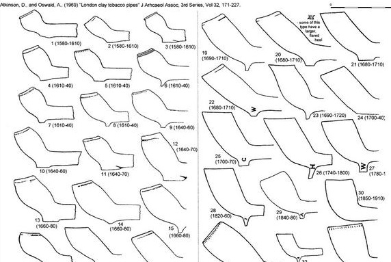
They were mass produced in huge quantities using a white ‘pipe clay’ formed in a mould, and then kiln fired. In terms of date, they are quite difficult to pin down precisely without lots of detailed information. The rule of thumb though is that the smaller the bowl, the earlier the pipe – tobacco was very expensive in the 16th and early 17th century, but became much cheaper later on, leading to larger bowls, and a more wide appeal. There is also some chronological variation in the stems too – the earlier pipes had thicker stems and the bore (the hole down the middle of the stem) was wider too. And there are also very subtle changes in shape of the bowl, the stem, the heel, and the tip, that allow rough dates to be given to the pipes, but these too are very broad. A huge amount of work has been done on dating pipes, but the reality is that it is not hard and fast, and unless you have a manufacturers name or mark, or it comes from a secure archaeological context, pipe dating is in half centuries and decades, rather than specific years.
Here are some images showing dates for various pipe styles. It is worth remembering that each area has its own industry making these things, and thus what might apply in London, will probably not apply in Manchester, although the broader trends are applicable, and pipemakers did copy each other’s designs.
London pipes showing the broad trends regarding sizes through time.
A rather general image giving dating information.
So then, the pipes.
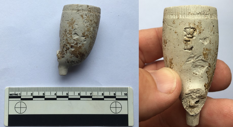
This first one is something of a rarity in that we can say a bit about it, and it has a date. It was found with some late 17th and 18th century pottery near Crowden, and thus I assumed it was of a similar date.
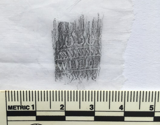
The decoration is at the left of the stem
It was only when I cleaned it that I realised that it had a rolled stamp around it which at first I thought was simply decoration. It was only after I had taken a rubbing that I saw the name ‘WILD’ printed. Fantastic!
It amazing the things you can do with cigarette papers.
Even more amazing, after only a few moments rummaging around some files, I found a perfect match to this stem from an excavation in Sheffield. This truly never happens! It was made by Thomas Wild, a pipemaker working in Rotherham between 1750 and 1790 – which is absolutely spot on for the date of the pottery.
I’m hoping you see the match.
The published version of mine is is in the Clay Pipe report by S.D. White (2015) to be found here (No.13 in the catalogue). The location of Crowden on the Woodhead Pass means it would have had easy access to the market at Rotherham, and thus the pipes. Honestly, it’s not often that you can make a connection like that – the place of consumption to the place of production, and all along a single road. It’s even been made in the same mould. It’s things like this that keep me alive in archaeology, and makes it all worthwhile.
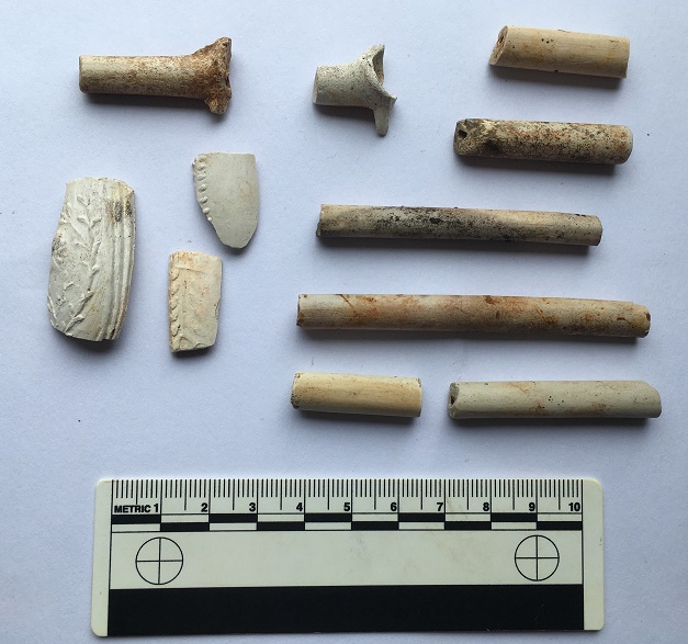
I found a few other fragments in the area of this pipe but nothing as spectacular as the stem, alas, although the bowl sherd on the bottom left is quite nicely decorated, and dates to the same period.
The top two bits are also quite nice, being the back part of the bowl where it attaches to the stem, and with the spur underneath.
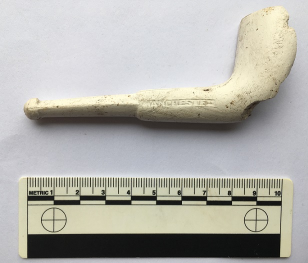
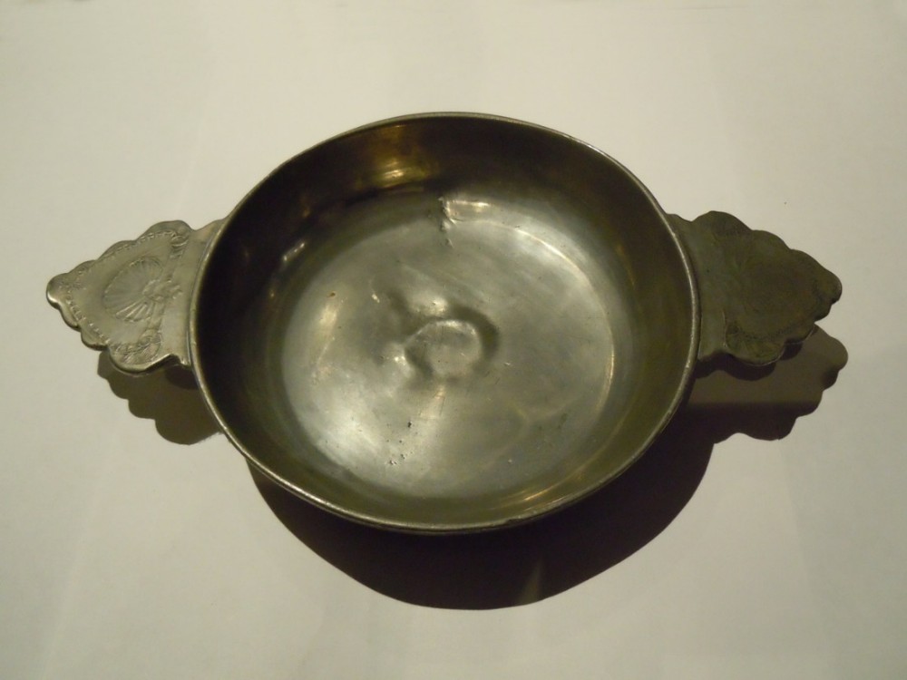
The next one is also a great find. From a Victorian dump near Hadfield, it just plopped out of the earth soil right in front of me.
Beautiful!
It is almost complete – missing just a part of the bowl – and looks as though it had never been smoked before it was presumably dropped and broken. It is an interesting shape in that it has a short stem, which means it was made for a manual worker of some form. The last thing you want if you are wheeling a barrow around or swinging a pickaxe is a long stem that would get caught and break. Manual workers would normally break off the stem to create what were called, for obvious reasons, ‘nose warmers’. Manufacturers caught on, and they made short stem pipes for such a market. This one, helpfully, has the manufacturer’s name on the side: Samuel McLardy of Manchester.
Helpful people – sometimes – these pipemakers.
I was going to give you a history of McLardy as a pipe maker, but this blog run by a pipe expert has done an amazing job already (it’s well worth a look). Briefly, then, McLardy was born in Glasgow in 1842, and set up his company in Manchester in 1865 in Miller Street, and then later in Shudehill. By 1895 the company was making over 5 million pipes per year, which is astounding, but in keeping with clay pipes in general, sales dropped, and the company was ended in 1930. There is a sales catalogue from the 1920’s in the above blog, in which the above pipe is listed as #392 (page 1). This provides us with a good date for the pipe – roughly 1920, or possibly a little earlier – very late in the history of clay pipes, which is interesting.
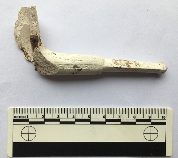
Also from the same dump, was this lovely, if battered, bowl.
Some nice rouletting around the rim.
Large, so late in date (1860-80 ish) it is marked with a crown above the letter ‘L’. A little bit of online research produced this article, which details the ‘Crowned L’ as a trademark of superior Gouda pipemakers of the 17th and 18th centuries. However, by the 19th century, English and Irish pipemakers were freely using the ‘Crowned L’ as a way of claiming that their pipes were of a similar standard, so the trademark became debased, and these pipes are very common. Incidentally, what on earth did we do before the internet? This sort of research would have taken weeks, months even; it took me less that 30 seconds – longer, in fact, to write this. Incredible.
I’ll end on an excellent, although sadly not complete, Victorian pipe. In the spirit of truthfulness, I should admit I found it on a Victorian tip in Lancashire, nowhere near Glossop, but it’s such a wonderfully ugly thing that it deserves its moment of fame.
Ah, the garish Victorian aesthetics!
It is an eagle’s claw holding an egg. Of course it is… what else would you want to see whilst you were puffing away on your pipe – the Victorian equivalent of heavy metal fashion. It is missing two talons, but still quite remarkable. Apparently the Victorians were really into their novelty pipes – football being a particular favourite subject.
I know I keep saying it, but I love clay pipes.
Right, that’s your lot for now. Please send me your pictures or comments about pipes, or indeed about anything vaguely historical/archaeological… all comments are welcome.
But for now look after yourselves and each other, and until next time, I remain.
As I have said many times before, I do love alliteration. What ho! and all that. I trust you are all keeping well in these odd times? Well, now this is a monumental post – it is precisely three years to the day that I made the first post on this blog (you can read it here if you want). When I first started it I had no idea what it was going to be, other than I had some interesting bits and pieces that I wanted to share, and which I thought other people living in Glossop moght be interested in. The blog is still pretty much that in aim – bits and pieces – and I was right… there are lots of you out there who seem to enjoy the ramblings of a man who gets excited by bits of old rubbish. So thank you, you wonderful people, for reading, and here’s to many more blog posts. Now, on with the show. RH
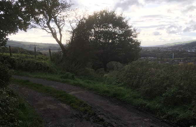
During the lockdown, Master Hamnett and I have been taking a daily constitutional up and around what has become known as the “secret passageways”. Overgrown and wild in places, even for a man of modest size such as myself it is a mysterious place, but to a 4 year old it is indeed another world. Naturally, I have been keeping an eye open for bits and pieces of history, and I think I have a story to tell. Possibly. Well, I certainly have some pottery to show, so there’s that!
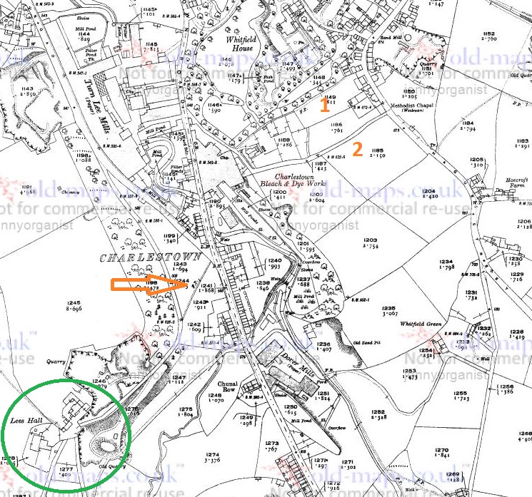
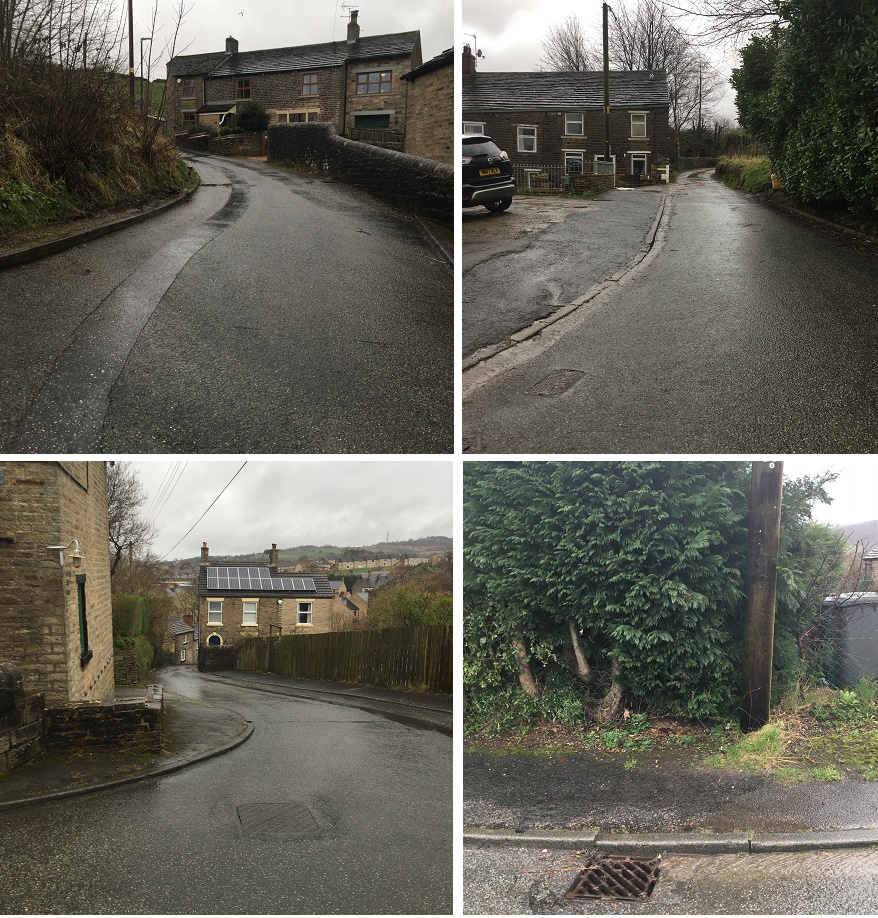
The route we walk is essentially along Hague Street, down one track to Charlestown Road, along, and then up another back to Hague Street. We often continue on and round if it’s not raining, but always walk these paths, which I have helpfully marked Tracks 1 and 2 on the map below:
Tracks 1 & 2 at the top. Ignore the arrow and a circle for now… all will become clear!
The tracks and immediate area are more clearly shown on the 1968 1:2500 map
It’s a nice and short circular walk, if anyone fancies it.
The tracks are interesting in themselves in that they are once again an example of what I call the fossilisation of trackways – they are older tracks that no longer perform a function as such, but are preserved as footpaths. Certainly in this case as it makes no sense to have two tracks mere metres apart going between the same places. Instead, I think they are preserving the memory of a single older track, which I suggest below is Track 2, potentially the more interesting of the two. But I’m getting ahead of myself.
Track 1 runs down the side of this house, which was originally a pub called the Seven Stars (hence the sign on the door frame, although the sign above the door is a mystery… if you are reading this and own the house, could you tell us?).
The one-time Seven Stars pub – I always feel a bit weird photographing people’s houses, but this is visible from the road, so it’s not as though I’m sneaking around gardens.
I know nothing about this establishment, but it was probably a beer house. As a reaction to the widespread and dangerous consumption of cheap gin – the so-called ‘Gin Craze’ of the late 18th century – the government encouraged more beer drinking (beer being considered relatively healthy) by allowing householders to open up their houses to brew and sell ale. These private houses became known as beer houses, and the individual paid a small fee to the local magistrates in return for an annual license allowing them to sell beer, but not the wines or spirits that the normal pub or inn could. If anyone has any information about the Seven Stars, please do get in contact.
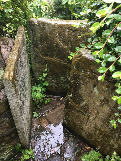
Just here is a series of upright stones presumably placed to stop horse riding or cycling. The gap between them is very thin; I might have put on a little weight during lockdown, but even I had to squeeze through.
Breath in!
Carved onto one of these uprights are the intials ‘M.D.’ – I must have walked through these 100 times and never noticed the letters before, but the light and the rain were just right this time.
And as you all know by now, I can’t resist carved graffiti.
Further down the footpath I noticed a reused quern or grind stone – possibly Victorian, but I suspect earlier – being used as a coping stone for the wall. And why not? It’s the perfect shape, and may well have been hanging around for centuries after being used to grind wheat into flour.
The worn central hole is visible, and it’s possible the other half is around here somewhere.
About halfway down, you come face to face with more of those upright stones, although in this case I can only assume they were put there to stop a headless horseman! Honestly, they are quite unnerving.
Not at all creepy and gravestone looking. Nope. Absolutely not.
The path continues:
Master Hamnett on the final stretch down to Charlestown Road. At the end of the path, in spring, there is a truly spectacular spread of wild garlic.
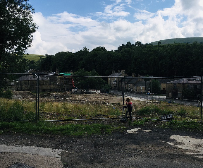
Until we arrive at Charlestown House, and the Charlestown Works that were – now demolished and awaiting houses.
The site awaiting re-generation. The hairpin bend where Charlestown Road meets Turnlee Road is visible. Whitley Nab in the background right, Casa d’Italia left (very nice pizza, highly recommended). Dead ahead is Lees Hall, which is important… stick around!
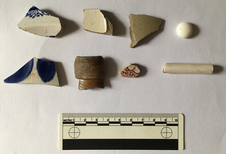
So, here’s the pottery:
A small assemblage of fairly typical Victorian bits, with a potentially earlier piece.
Top row, from the left: a base of a saucer or small plate; a huge chunky handle belonging to a large jug; a base of a glass jar or jug, or possibly from a tankard – it’s nice and decorative, but not expensive. Next is a fragment of a pedestal footed drinking cup, which is again fancy, but not especially expensive, it being just glazed earthernware. Then there is a rim to a large plate of some sort, being about 30cm in diameter.
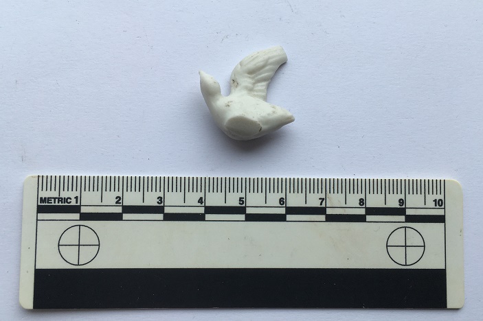
The lower row from the left: a fragment of a stoneware bottle, a chunk of a pancheon, and a fragment of a manganese glazed jug or similar thick walled vessel. Then we have two pieces of blue and white earthernware, and a base of a tea cup. There is nothing massively interesting, and it all seems to be Victorian in date, as we might expect… except for the manganese glazed jug! This is, I think, earlier – perhaps early 18th century. It’s quite characteristic, and although there was a revival of manganese glazed pottery in the Victorian period, this glaze is of relatively poor quality, and the fabric (the actual clay of the pot) is quite rough, both of which suggest an earlier date. Then there is this lovely bit of pot; it’s a china dove, shaped to fit onto what would have been a tasteless Victorian jug or bowl – you can see the flat bit where it was joined to the vessel it flew away from.
Found lurking below some dandelions.
Then there was this:
A bottle top
A screw bottle top, probably from a beer bottle or similar, and dating to the early 20th century. I love these things, and have blogged about them previously – here, for example. Unusually, this one doesn’t have the drink makers name or logo on the top, just the name of the bottler – R. Green of Leigh.
Always nice to see.
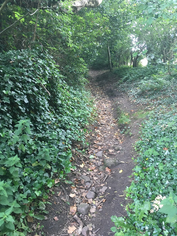
Moving on to Track 2, there is a noticeable difference between the two. This one is more of an actual track; it is certainly wide enough to drive a horse and cart down it, and it seems to have had a surface at some stage. It is also deeply worn in places, which can be suggestive of an older trackway.
Possibly worn by traffic, the track is quite deep in places.
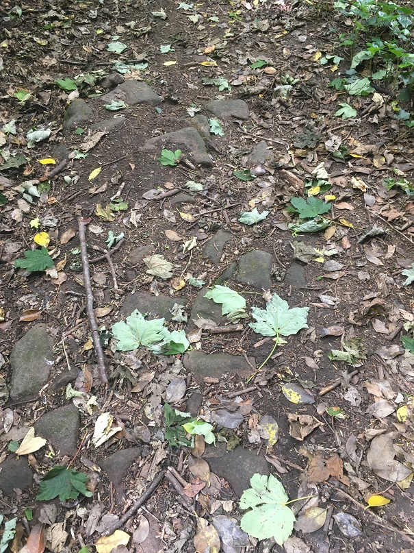
It’s not much to look at, but this is the surface of the track.
I’d love to put a trench across this track to see how it was made up.
Further on, it has what seems to be a late 19th or probably early 20th century cast-iron streetlight, which is interesting and spookily out of place now, but suggests strongly that it was used as a ‘proper’ track until fairly recently.
It has seen better days, but there it is, slowly being overtaken by nature.
I can’t work out if it is gas or electric… further research is needed.
Right next to the streetlight is a gateway into a seemingly random field, and a benchmark on the gatepost – it’s been a while! This one – 616.77 above sea level – is a late addition as it is only marked on the 1968 1:2500 map. There was another benchmark marked on the opposite side of the track – 622.6ft above sea level – but it’s long gone (you can see it in the map above).
The bench mark. This is what 616.77ft above sea level looks like.
The track continues until daylight is reached.
I love this shot… artful (courtesy of the iphone filters, not talent on my part). Mrs and Master Hamnett providing the scale.
The top of the track, where it joins Hague Street again, is the site of the original Whitfield Methodist chapel – it is visible on the 1880 1:500 OS map:
The chapel is clearly marked.
Built in 1813, it had seating for 200 worshippers, and at one time was the home of the pulpit from which John Wesley had preached in New Mills (as discussed in this post). There are more details about the chapel on the Glossop Heritage webpage.
It was demolished in 1885, and the site is now occupied by a private house, but there are some interesting re-used stones on the trackway which almost certainly came from the chapel. The one indicated by the arrow in particular seems to have been a window frame – originally it would have laid upright, and you can see where the wooden frame was bedded in, and possibly a cross bar set into the stone.
I love Microsoft Paint!
A closer look reveals what might be a mason’s mark. Possibly… but then I really rather badly need glasses.
Squinting, after two glasses of wine, and with the eye of faith…
So then, the pottery:
Fairly standard stuff, but still nice.
Top row, left to right: a fragment of a large stoneware vessel with a cream glaze. I have photographed it showing the interior – it is roughly finished, and you can see wiping marks, and it probably came from a large cider flagon.
Next is an annular ware bowl or similar type, with the characteristic horizontal linear bands around the rim and below. Abrim from probably the same vessel is above it. Despite it looking 1950’s, this stuff ranges in date from the mid-18th century to the late Victorian; this is, I think, early 19th century. Next is a sherd of a cream ware jug, this being a part of the spout – you can tell by the twisted curve of the rim – again, early 19th century. Next is a stoneware flaring rim to a large jar, Victorian in date. Next we have a sherd of black glazed pottery which, I think, might be 18th century in date – the glaze seems to be lead based, which it isn’t in the Victorian period, and the fabric is very red, which is also common in Black Ware of the 18th century. I’ll post some more about this in the future – I’m actually trying to put together a crib sheet for pottery identification for this part of the country which some of you might be interested in (I know, I know, stop groaning… you don’t have to read this blog, you know. And I did say ‘some of you‘!). Beyond that is a fairly uninspiring selection of Victorian sherds at which even I pale!
Track 2 is odd – there’s summat rum about it. It has the air of a deserted roadway that was once of some importance, certainly important enough to have a substantial gateway and a streetlight on it. Looking at it, and thinking about the fossilisation I talked about above, I wonder if this was the line of an earlier track, perhaps even the medieval road that led from Whitfield to Lees Hall (which is circled in green in the first above – see, I told you it would all become apparent!). The hall, though 18th century in date now, stands on the site of a medieval manor house, possibly even the original manor house of Whitfield mentioned in the Domesday Book. It was certainly important in the medieval and early modern periods as the seat of the Manor of Glossop, where tax and tithe from Glossop and Whitfield was taken – first to the Earls of Shrewsbury, and then, from 1606 onwards, the Howards. The road from (Old) Glossop came through Cross Cliffe (discussed here), along what is now Cliffe Road through Whitfield, and from there down this track to Lees Hall. One less obvious part of it may be the footpath indicated by the orange arrow in the map above; I don’t think that it is the exact route the track would have taken, but it again ‘preserves’ the way in the landscape. I would suggest, then, that Track 2 is either this hugely important road fossilised into the landscape, or it broadly follows the line of that road which no longer exists. A point that may also support this is that on the 1968 OS map, also above, the track is marked by a series of ‘Boundary Mereing Symbols” (they look like lolipops – circles on sticks) which apparently indicates that it is the boundary of a parish or parish council (here, for an explanation). Boundaries, or meres, often use ancient and established objects or features to lay out the area that is bounded – an old track is a very common and perfect example of this type of feature.
This part of Glossop – I suppose technically Whitfield – is very interesting.
Right, that’s your lot for today. As always, please feel free to comment – even if it’s simply to tell me I’m talking out of my hat. I have more that I am picking away at, but until then stay safe and look after each other. Oh, and happy anniversary.
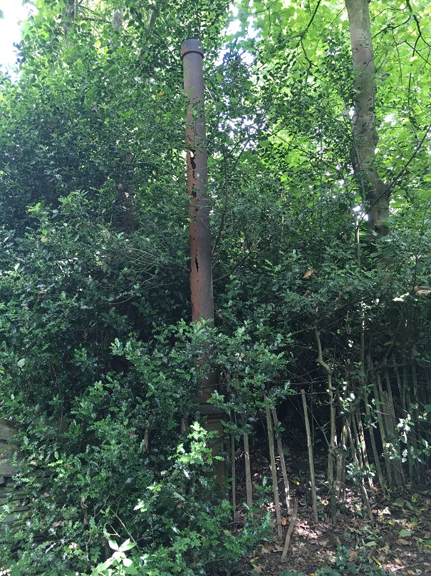
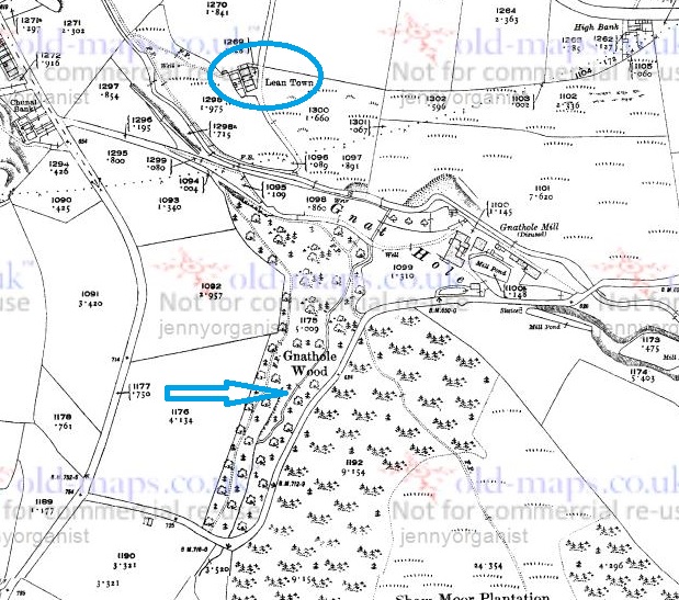
An interesting title, and a tantalising tale, today. I was originally going to post today’s topic at the end of the Lean Town posts (here and here), but after they became too large I thought I’d do it as a separate post.
Reading through Hamnett the other day, I came across this:
“The Gnat Hole Wood is very pleasant in the Summer time when there are no gnats about. The small stream of water that runs through the wood at one place forms a small pool; this was known as Old Nat Nutter’s Porridge Kettle. She had the reputation of being a witch and fortune teller and used this pool for unholy practices and incantations. She was a bogey to children.”
Interesting… I do love a good folk story, and one with tantalising clues, too.
So off I buggered (in those happy-go-lucky pre-covid times, when one could just bugger off into the woods) to look for the Porridge Kettle, and any signs of Nat Nutter.
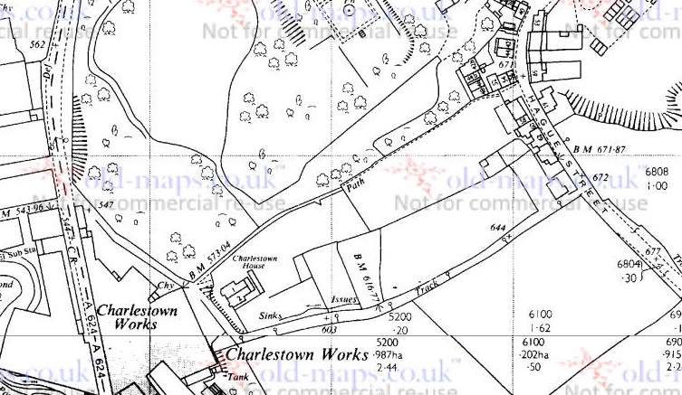
The stream referred to is, presumably, the one pointed to by the large blue arrow in the map below, as it is the only one to run through Gnat Hole Wood (or Gnat Hole Plantation, as the earlier maps name it).
The map of the area. For reference, Lean Town is circled in blue.
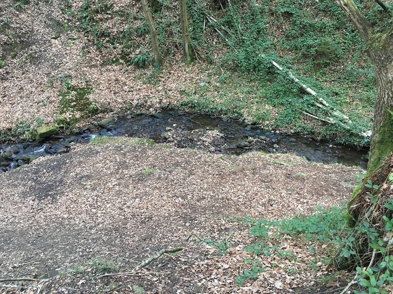
As far as I can tell, it is unnamed. I’m sure it had a name at some stage in its history, as watercourses are one of those landscape features that no matter how small – and this one is less than a mile long – are given a name, even if only a local one. However, we must remember that the surveyors who actually drew the maps, whilst superhuman, were not invincible – they might have had an off day, or it might have been raining and they didn’t fancy getting wet, or there was no one around to ask the name of that particular stream, or… you get the idea. Moreover, the fact that Hamnett himself didn’t know the name, particularly given his uncanny ability to “know things”, seems to indicate that the name was lost by 1910 (when the article was written), and probably a good deal earlier. The brook itself begins on, and is formed largely from the water run off from, Shaw Moor (perhaps we should call it Shaw Moor Brook) and it joins Bray Clough Brook between Gnat Hole Mill and Lean Town.
I travelled through the woods here, looking for a “pool”, or something that might match the description:
This is the upper part, with Bray Clough Brook below.
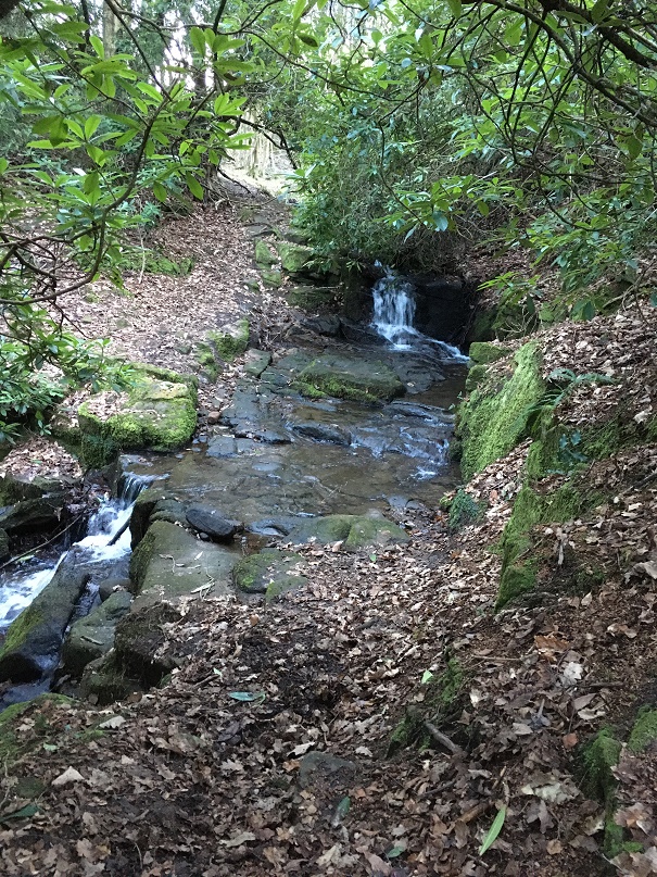
Here it drops into a series of waterfalls, in a steep secluded glade. Atmospheric to be sure, and perhaps a perfect place for witchcraft.
Lower down, and more open, but still steep sided
Alas, I found nothing that would definitely be called a pool as such, nor anything that could be connected to Nat Nutter. The area must have changed a huge amount since 1910, and even more so since the ‘witch’ was supposedly living there (early 19th century, perhaps earlier?), so it’s not surprising. Disappointing, but there you go.
So who was this Nat Nutter? Well, the description of her as “a witch and fortune teller” suggests that she was what is known as a ‘wise woman’ or ‘cunning woman‘ – a sort of combination of healer, folk magician, and someone who divines for fortune or lost objects. A particularly important function they performed was the production of spells and magically protective charms, as well as being a first port of call for medical matters, especially those involving pregnancy and abortion. They were common from the medieval period until the early part of the 20th century.
Whoever she was in reality, she was still remembered by 1910. Her name, though. Well, her name is suspicious, and is perhaps a construction – Nat Nutter, living in Gnat Hole Wood? Hmmmm. Also, the Nutter part recalls Alice Nutter, the Pendle Witch executed in 1612. It all seems a little too good to be true! But perhaps this was deliberate, the name adding to the mysterious otherness of the scary woman who lived in the woods by a stream that she used as a witch’s cauldron.
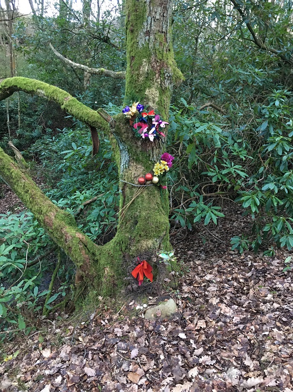
The old ways are not too dead – this tree is overlooking the brook.
Marvellous stuff.
Please feel free to comment, even if just to tell me that you are related to Nat Nutter, and that I have libelled her.
Stay safe, and look after yourselves and each other. More to follow soon(ish).
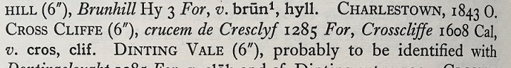
So, hopefully you all read the last post. And even more hopefully, it made sense to some of you. Ignoring the fact that the main point of writing it has been proven to be wrong, I mentioned in the post that I think there was once a crossroads at the bottom of Cliffe Road. Well, let’s concentrate on that! It’s just a t-junction now, where Cliffe Road joins Cross Cliffe (the road to the right), and continues down to Volcrepe and Bank Street (left)
The site of the possible crossroads, and of Cross Cliffe Cross.
But originally, I suspect, it would have gone straight on, right up to the bridge that crosses Hurst Clough – like this:
The photo above shows the area circled in red, the proposed road is shown in green. The footbridge is noted on the map as FB.
However, the whole area has been monkeyed around with pretty seriously, with the main culprit being the building of a Cross Cliffe Mill on Hurst Clough there, as you can see very clearly in this map:
The 1880 1:500 map shows both the mill and the projected route of the track. Interestingly, there is a gas lamp post marked at the junction.
So then, Cliffe Road is at the bottom, and Cross Cliffe runs to the right. My contention is that Cliffe Road once also continued on to the footbridge at the top of the map, and from there on to (Old) Glossop. Let me walk you through it.
Cliffe Road is the original medieval (and probably earlier) track that led from Hayfield down to Old Glossop (discussed HERE), and on which, at the junction of Whitfield Cross, stood the Anglo Saxon stone cross of Whitfield. Beyond this, it continues to what was originally a crossroads.
The crossroads circled in green, with the arms shown roughly in red.
This crossroads was the junction of Bank Street (The Bank, coming ultimately from the Simmondley area), Cross Cliffe (the road leading to… well, I’m not certain, yet.), Cliffe Road (from Hayfield), and the track to Old Glossop heading north. But with the building of the mill in the early 1820’s, and specifically the mill pond, the old track was destroyed, pushing traffic further back toward Bank Street, and then along what became Volcrepe and Milltown, and giving us the kink in the road.
Clockwise from bottom left: road down to Bank Street and now Milltown; Cliffe Road; Cross Cliffe; er… a hedge! The now blocked northern arm of the road.
Although the northern arm of the crossroads is no longer there, there is a path way preserving the route running to the right of the houses and leading down to the bridge.
The path beside the houses, preserving the memory of the trackway down to the bridge.
The original track lead down to a crossing over the brook there. It is now a modern concrete modern footbridge, but is clearly shown in older maps, and is thus presumably an older brook crossing – whether by bridge or as a ford.
The bridge over Hurst Clough, standing in Whitfield and looking into Glossop… bandit country!
After crossing the brook, the track continued along what is now a curiously wide and unusually placed unnamed footpath between Shirebrook Drive and Silk Street.
The track looking from Silk Street toward the footbridge.
I would suggest that this footpath is the memory of the original medieval and early modern trackway preserved (perhaps fossilised is a better word), as these things often are, in the Victorian architecture. Glossop is full of these odd footpaths that lead from A to B for seemingly no reason, and often for no gain; they just exist. I have suggested that Whitfield Avenue preserves the memory of a track, which in itself preserved the memory of the Roman road, and I wonder how many others also preserve a memory of a track or road (watch this space for more explorations). From Silk Street, the track would have gone up what is now Manor Park Road to [Old] Glossop, and the church and market there.
So there we have it – a lost crossroads, and the rediscovery of the medieval way into Glossop from Whitfield.
Comments, even to tell me I’m wrong, are always welcome.
In the meantime, stay safe, look after yourselves and each other, and there is more coming soon… honestly!
Alas, a mis-attribution in the Place-Names of Derbyshire has meant I have barked up the wrong tree! That’s not to say that there definitely isn’t a cross at Cross Cliffe, as suggested below, just that we can’t rely on the early place name evidence. Read the insightful comments by Neil Buckley below, which give what must surely be the correct reading of the text. My thanks to him for supplying the information, and working out the details. I’ll return to this in a later post as I think it is important, and in the meantime, feel free to re-read the blog post.
You know those moments when something that you have been staring at for years suddenly, and jarringly, comes into focus, and there is a slight tingle at the back of the neck. And then you dig a little deeper, and the tingle becomes a hunch, and then a possibility, and then a… you get the idea. Well, I’m there, and I’d like to share a discovery with you. This is still theoretical, even if the theory is based on good evidence, and I’m fairly certain that I can never prove it. But I’m getting ahead of myself.
Diving in and out of The Place-Names of Derbyshire to various previous blog posts (HERE and HERE) was a joy, and had me marvelling at both the sheer number of placenames recorded in the book, and the incredible depth of scholarship that accompanied their explanation. For those that have never read the book (and you should), it is a list of all the names of towns, villages, fields, roads, and streams in the area. However, on page 104, under the Glossop general heading, I came across a curious entry that got me thinking.
Here is the page in question
Specifically the entry for the road/area Cross Cliff, in Whitfield. For those of you who don’t now the area (and why not?), Cross Cliffe is this area, here:
Cross Cliffe is broadly that area circled in red.
Although now it gives its name to a road, it was once an area (circled in red above) which started at the bottom of Cliffe Road and lead down to Hurst Clough. The entry in the book reads:
Cross Cliff (6″), crucem de Cresclyf 1285 For.
It gives the earliest example of the name (crucem de Cresclyf), the date of this (1285), and the reference for this example (For = Forest Proceedings). So far, so perfectly ordinary.
So then, Cross Cliffe… and then a thought. “Hang on a minute… Crucem de Cresclyf?“
Now, I’ll admit it, my medieval Latin is about as good as my understanding of the language of the San people of Botswana – the one that uses clicks and other sounds. Or indeed, Klingon. I checked, and was – broadly – right (hurrah… personal victory, I’ll take that). I also checked with a real linguist (thank you AG), and was – broadly – backed up.
Crucem de Cresclyf: the cross of Cross Cliffe.
The cross? Which cross? Oooooh…
Bloody hell, thought I, and I went and bored Mrs Hamnett with this potential discovery. More research later, and I think I have just about convinced myself.
This, the first reference to Cross Cliffe, is taken from a 1285 document which gives a description of the boundary of land owned by a certain Thomas le Ragged. Thomas was a forester in the Peak Forest, and was given the lands by William Peverel, son of William the Conquerer and resident of the castle in Castleton. These lands included the hamlet of Whitfield. The descendants of Thomas le Ragged sold the Whitfield portion in 1330 to a John Foljambe, and from there it was portioned off and sold in lumps (Whitfield really does have an interesting history).
The description of the boundary of this land reads: Required by the Foresters and others concerning the metes and bounds of the land of Thomas le Ragged of Fernley who claimed liberties, who say, that the metes and bounds of the said lands of the said Thomas begin at the Bridge of Welegh by the Royal Way to the (cross) to Crescliff, and from the said cross by certain caves (fovia) up to Routing-clought, and from Routing to Brownhegge, and up to the Waynstones, and from Waynstones descending to the Hocklow, and from Hocklow descending to the water of G’wit and by the water of G’wit ascending to the wood of Horworth.
Boundaries are based on and related to landscape features, and always incorporate immovable and visible objects, ones that can’t be disputed. Now, out of this, only a few points are identifiable. Whaley Bridge, Cross Cliffe, Hucklow, the River Goyt (G’wit), and possibly the Wain Stones on Bleaklow (although, I suspect that it may reference another ‘Wain Stones’, now lost to us). The other places I have not been able to identify (any help would be appreciated), and I’m not sure what to make of the caves – are these literal or figurative, and does a cave (fovia in the text) in the 14th century mean the same as it does now.
I digress, as the important bit here relates to Crosse Cliffe, or rather “crucem de Cresclyf” as it is in the orginal – the cross of Cross Cliffe. Not the bridge at Cross Cliffe, or the brook at Cross Cliffe, but the cross at Cross Cliffe. This is at a time when they didn’t use metaphors or flowery terms for place names – if it says the cross at Cross Cliffe, it meant the cross at Cross Cliffe. A physical, actual, stone cross. One that has been there long enough for everyone to know where it is, and use it as a point of reference. Which is very interesting. A previously unknown cross.
Its location also would support this. It would be situated on a crossroads – a favoured spot for crosses of this sort (Whitfield Cross for example). The present layout of the roads does not show this easily, but they have been changed, probably in the 18th century – I’ve got a post almost ready to go that explains all that, but here is a map to help:
The cross roads, with Cliffe Road coming from the bottom, Cross Cliffe (the road) on the right, Bank Street on the left, and the original line of the road heading down to the bridge/ford over Hurst Brook, and on to Old Glossop. The green circle marks the – hypothetical – location of the cross. For orientation, the red star marks the location of what was Volcrepe.
The upcoming blog post will make a lot more sense of this area, but for now, roll with it!
This is broadly the area in which the hypothetical cross would have stood. It was once a crossroads, with the road having continued on and down to Hurst Clough 50m away. Probably.
Importantly, the cross would have stood at the border between the manors of Whitfield and Glossop – effectively Hurst Clough – and boundaries like this are exactly the sort of places that crosses are erected. Then there is the name Cross Cliffe. I had always, at the back of my mind, assumed that it meant the place where you crossed the cliff – perhaps a tall edge over Hurst Clough that no longer exists – or simply references the footbridge here. Well no. Delving further into the etymology of the name, it is derived from ‘Cliff‘ meaning a steep river bank, and ‘Cross‘ meaning, well, a cross. The name is literally ‘the steep river bank with a cross on it’, and crucem de Cresclyfe is then ‘the cross of the steep river bank with a cross on it‘. This a perfect description of that monster of a hill – it drops from 650ft at Bright’s Terrace to 500ft at the bridge over Hurst Clough – a 150ft drop over roughly 1000ft.
Placename evidence, coupled with a physical description, and a reading of the landscape and roads, seems fairly convincing. Well, to me anyway.
Now, there might a possibility that I am reading too much into this (‘surely not!’ groans everyone… I can hear you, you know! Don’t think I can’t). The ‘Cross of Cross Cliffe’ might refer to Whitfield Cross which would have been situated at the start of a small rise before the long steep slope down to Hurst Clough. If this is the case, then there is no need to look for another cross. However, I’m just not sure that this is the case. For one, the wording is too specific; “the cross of Cross Cliffe”, not just Cross Cliffe as an area – Whitfield Cross would surely have been too far away to be the cross described there, it is firmly in Whitfield, not Cross Cliffe.
The red circle marks the original location of Whitfield cross, the green circle marks the location of the hypothetical Cross Cliffe cross – a distance of over 1/3 of a mile.
Moreover, if Thomas’s land went to just the Whitfield Cross, then everything beyond that – including what is now Cross Cliff – would be outside of the described land. No, it makes sense his land went to the very edge of Whitfield, and the natural border of Hurst Clough, and it used a cross at the crossroads there as a marker.
What type of cross would it be, then? I would suggest that it was probably the same type as that which originally stood further up the same road at Whitfield – a 10th century Anglo-Saxon stone cross.
If this is correct, then where is the actual cross? 1000 years is a long time for a stone cross to survive. It may have been swept away in the iconoclasm of the Protestant Reformation of the Tudor period, or the iconoclasm that followed the Civil War, when crosses were routinely smashed – I read the other day of a Saxon cross that was broken up and used to fill a pothole in a road. However, the fact that Whitfield Cross survived these periods would suggest to me that Cross Cliffe would have likely survived, too. Perhaps we are looking at something more mundane; maybe it was accidentally broken, or worse, simply forgotten about as an important object, gradually falling into obscurity, to be lost in the hedgerows. Perhaps – and this really is a flight of fantasy – the stealing of the Whitfield Cross by the Cross Cliffe lads as a Mischief Night prank was not just a prank, and instead they were stealing a cross to replace theirs that was lost. It has never made sense that they would steal something so ridiculously large and heavy, so is this the answer? Well, probably not, but one can speculate wildly!
If anyone fancies joining me looking in hedgebacks and ditches for the original cross – after the current corona madness has subsided, obviously – then please drop me a line.
More soon – as I say, I have a whole post about the crossroads almost ready to go.
Until then, stay safe and stay inside, and take care of yourselves and each other.
Apologies for the lack of posts recently, but things are a bit odd at the moment. Six weeks ago we were concerned about Covid19, but were still joking about it, and how it will amount to a fuss over nothing. Now, here I am in front of my computer in ‘lockdown’ for the foreseeable future, and a very real and sobering death count is still rising. It really is a strange time, and the country is a strange place; the start of it all reminds me of what my grandfather said of the ‘Phony War‘ – you knew something big was happening, but it wasn’t actually happening there and then. Well it is now.
Sadly, it also means that we have had to cancel all the tours and talks that I was involved in that were about to occur: in particular, the ‘By Seven Firs and Goldenstone‘ exploration of the legend and landscape of Alderley Edge, and the Objects Tell Stories evening of folklore and archaeology. Oh, and if you want to find out who I really am, you can watch me talking archaeology and ritual in the promo for that event here – I’m the one on the right.
More to the point, this has put something of a crimp in the Cabinet of Curiosities. Rest assured, though, I do have a backlog of posts that I have been trying to write that doesn’t involve me moving anywhere. And of course, there is now time to write… well there would be if Master Hamnett wasn’t being home schooled for the duration.
In the meantime let’s keep buggering on, as Churchill was fond of saying.
So I went for my state-mandated exercise the other day and found a few bits and pieces – random is the theme of today’s post. But first, a quiz. What’s this?
Ooooh, a mystery object!
I’ll give the answer at the end of the post… no peeking!
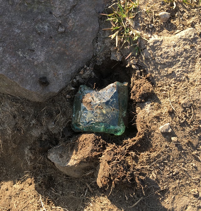
In the meantime, I spotted this sticking out of the ground:
Ooooh, thought I. The greenish colour of the glass gave it away as being older than mere litter, along with the thickness of the walls. Master Hamnett helped me hoik it out of the ground, and cleaned up it looks like this:
The lovely pale green colour is the result of impurities in the silicone, and dates it to the Victorian period or thereabouts.
You can just about make out the word ‘Glossop’ impressed in the glass. This was likely to have contained either carbonated water or beer, but a brief search of bottles reveals nothing similar. More research is definitely needed.
The small white object next to it is a fragment of a clay pipe, but interestingly, it has a some molded decoration on it. Here it is in close-up.
This is a fragment of stem, just at the point where it joins to the bowl. It is unclear what the completed decoration would look like – foliage perhaps? Dating clay pipe stems is always tricky, but the decorated types are usually late, so late Victorian is about right.
We later came across this stone with the letter ‘H’ carved on it, and being a connoisseur of such graffiti, I had to collect it.
A Hague Street ‘H’
It’s nicely executed with a flourish of decoration in the form of drilled holes between the arms of the ‘H’ – I’d give it a 7/10.
Right. That mystery object… did you get it? I believe you, honestly!
Ok, well, it’s a cheese press. Yes, you read that correctly! A cheese press. A thing for squeezing the whey out of cheese curds. Well, technically, it’s half of a cheese press – it’s missing the right half.
The square hole on the left is to house an upright pole which, along with another on the right, now missing, held the pressing weight in place. The circle and lines carved into the surface allowed the whey to run off, leaving behind the solids which are then matured to make cheese. Cheese was home made, or at least farm made in small batches, until relatively recently, so the press must have belonged to a farm nearby, as you aren’t going to shift that stone any great distance, when others, closer, would do to fill a hole.
The mystery object again.
Here’s a complete one in Bashall Eves in Lancashire:
Cheese press in Lancashire, and used to make, well, Lancashire Cheese. Image shamelessly stolen from Wikipedia.
And here is another one carved in the same manner as ours:
The cheese press in Draycott in the Moors churchyard. Photograph is courtesy of their local blog, and I hope they don’t mind me stealing it – please visit the blog here, it’s very good.
This one caused a bit of confusion, apparently – read all about it at this wonderful blog.
In terms of date… who knows? Certainly not hugely old – possibly Victorian, but equally possibly earlier. The only other one I have seen (which is how I know what it is) is propped up where I work at The Blackden Trust, and was in fact carved on the reverse of an old gravestone dated to the early 18th century, which at least gives us a date to work with. I’m going to write a little more about this soon, as it involves two of my greatest loves – archaeology and cheese… if we could just work in wine somehow, then it would be perfect.
Incidentally, the press is currently being used to fill a pot hole in a trackway, which I think is a shame. Sigh… I’ll add it to the list of historical objects things that need to be hoiked out and displayed properly (along with Whitfield Cross and the Whitfield Guide Stoop) – I think it would look great displayed at the wells. Seriously, I think we need to do something about reclaiming our heritage, as it is being slowly eroded. The guide stoop is currently under 3ft of soil, and looks like it will be left like that, So then, who’s with me?
Right. I’m off do some more gardening.
Please stay inside and stay safe, and take care of yourselves and each other.


![pipes[2]](https://glossopcuriosities.co.uk/wp-content/uploads/2020/07/pipes2.jpg)
![pipes[1]](https://glossopcuriosities.co.uk/wp-content/uploads/2020/07/pipes1.jpg)