What ho, you wonderful folk, you. Well, you join me in full panic mode – I promised a December post (actually, pre-Christmas was the promise, but let’s overlook that), and here we are with mere hours of the month, and indeed year, left. Christmas was, as always, busy, especially having the new Job taking almost all of my time, and so I have been lacking in the blog – and pottery – department. And also… Hmmm? What’s that? What do you mean “we don’t care, just get on with it!“. Alright, hint taken… I do have a tendency to ramble on and, you know, procreating – if that’s the word I’m fumbling for – instead of actually doing the thing.
So then… pottery. Taken from my overflowing finds tray that needs to be sorted before Mrs CG sees it. Some choice pieces, perhaps? Okey-dokey!
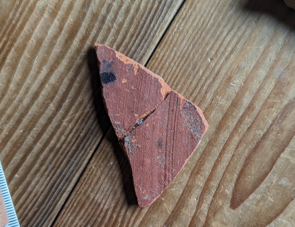
First up, a simple tea cup fragment.
Very delicate Bone China, with walls less than 2mm thick (you can see light through it), and rim diameter of 9cm. Nothing fancy, and certainly not old (late Victorian), and not even particularly good quality – the transfer printing is a little ropey in places. The design is that of the Willow Pattern spurious legend, and you can just make out one half of one of the birds into which the lovers transformed in order to escape. At first I wasn’t sure why I had this in my finds tray, but then I remembered Master CG and I had found it together on Bank Lane in Tintwistle/Hadfield. It’s also a nice example of its kind.
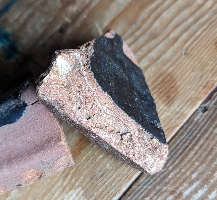
Next we have this beautiful specimen. And yes, I realise that beauty is in the ‘E’ of the ‘B’, or something, and that equally yes, I am possibly certifiable.
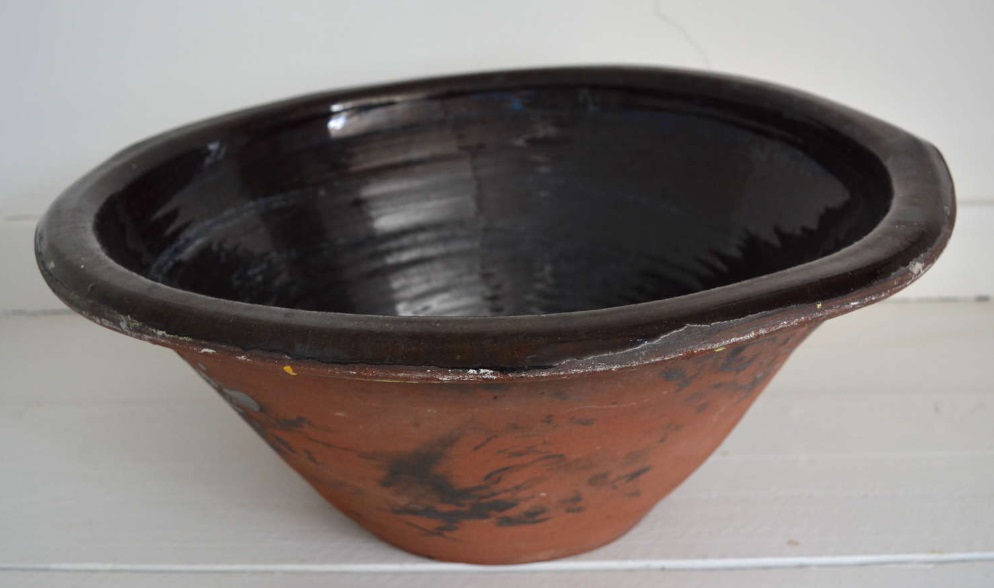
Slightly larger and distinctly less delicate than the first example, we have a Pancheon rim. It’s a huge example – 50cm in diameter – and is chunky. Glazed on the interior, as is traditional, it has a red slipped exterior, and is really roughly finished, which I quite like – there’s a sense of practicality about it, a no-nonsense pot, if you will. There’s smoothing marks all over it, too, and great lumps of inclusions popping through the surface.
If you look at the fabric, you can see the characteristic marbling, with a buff coloured clay mixed with a reddish. It was found in the spoil from a hole dug in Whitfield Cross, and probably dates to the late 18th or very early 19th century, which would make sense as this was when the road was laid out and surfaced. I honestly love this.
You can see the glaze on the interior and red slip on the exterior, with wonderful wiping marks left by the potter, and the characteristic fabric type.
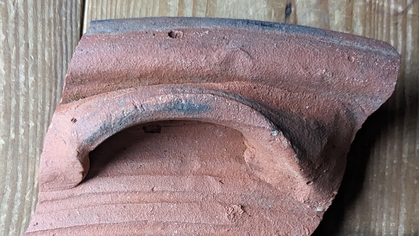
It’s from the ledge rim of a plate, probably something like the sherd on the left in the image:
It has the characteristic Staffordshire buff fabric, with the usual inclusions, making it very identifiable. The fact that is comes from the area of the Guide Stoop, on the post-medieval path there, is perfect in terms of dating. I like it when it comes together like that!
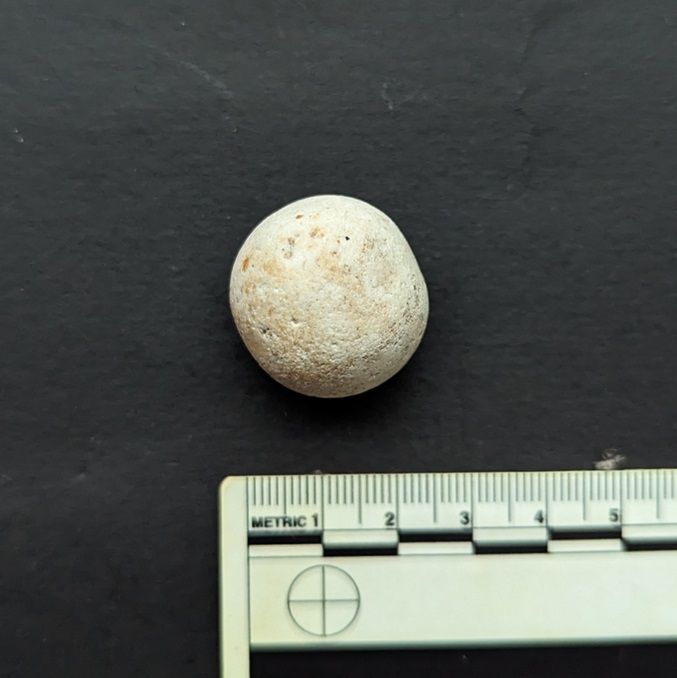
Finally, we have this lovely thing – a ceramic toy marble, and a large one, too – 2.5cm in diameter. I wonder, does this qualify as a ‘dobber’?
It’s not glazed, and is slightly off being perfectly spherical, but is quite beautiful, and marbles are always welcome finds. This, too, came from the area around the guide stoop – it really is the area that keeps on giving!
Right then, that’s your lot for this post. I have a double whammy of somewhat speculative Anglo-Saxon based posts that need finishing off, and a whole pile more pottery ready to go (look, don’t moan… all this pottery is good for the mind, body, and soul). I’ve also got a new Where/When to explore and publish, and there are more Wanders planned for the new year. So lots more in 2025, but for now, enjoy the last hours of 2024, and, glass of the stuff that cheers in hand, here’s a health to you and yours.
But do look after yourselves, and each other. Christmas can be a difficult time for some people, so it’s always good to keep an eye on those around you, even if you don’t know them. Until next time, as ever, I remain.
I know, I know! Another instalment of the seemingly never-ending Rough Guide… it really is the gift that keeps on giving, isn’t it! I can see and hear the hubbub from here. The yelps of excitement, the whoops of joy, the screams of happiness… lots of these. And the exuberant dancing in the street. It even looks like people are running away from me… what fun! And oh look, that man over there has started drinking what looks like cheap vodka from a bottle, and is shaking his fist at me in a cheerful expression of his enthusiasm. Steady on, there’s a good chap…
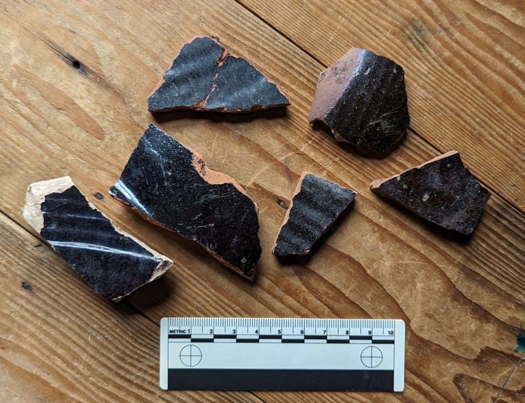
So then, today’s offering is simply black pottery.
At most places you encounter pottery, you will find sherds with a black glaze on them. Of varying quality, and of various sizes and forms, there is always a background noise of them, as a wander through the archives of the site will show. It’s less common than the Blue and White stuff, but you will find it. Most often as a big sherd of a thick walled vessel – a chunky rim if you are lucky – but more often featureless body sherds that feel like they ought to be able to tell you something… but don’t. Mostly these are difficult to date; one black sherd looks very like another, and without having the whole vessel to look at, it can be futile to try – even I just mentally lump most of them together under the banner ‘Victorian’. And largely I’d be correct (as if you ever doubted me!). But… actually there are subtle differences that can give a little more information and provide a rough date.
The problem is that Black glazed pottery is just that. Pottery… with a glazed black surface. So you can see how assigning a date to it might be a tad difficult, and whilst there are some broad observations to be made, the finer points of interest are missed. It has taken me this long to fully wrap my head around it, and I think I have it straight, though even now it’s fuzzy in places. I don’t like ‘fuzzy’. I like things to be simple and logical and straightforward, with neat edges and exact dates. Today’s offering has none of that and is full of fuzzy, which frankly makes me feel a little uncomfortable (does anyone else feel that these little interludes are starting to sound like a therapy session? What do you mean “we know you’re a raving lunatic, get to the pottery”… honestly). No, they are a problem, and quite rightly most people shy away from them; I mean to say, these bally Herberts frighten me… I can only imagine what your normal non-sherd-nerd would make of them. No… by and large it’s safer to just leave them. Unless, of course, some lunatic tries to impose some form of order on it, and takes a trip to the dark side in order to investigate Black Glazed Pottery.
Well… cometh the hour, and cometh the lunatic.
The following is a rough outline of what, where, and when; it isn’t final, it can’t be applied as a law, and certainly not everywhere, and there are always exceptions, and always overlaps. Indeed, we can only speak here of a pottery making ‘tradition’ rather than clean-cut specific ware types, and people have been making pottery in a black-glazed tradition for over 500 years. But it will allow you to look at your black sherd and say “oooh, that’s probably a…”, which is sort of the point of this guide (no, Mr Shouty-Outy, despite what you think, the point of this site is not to attempt to be “the dullest thing on the internet“, thank you very much).
So, we start today somewhere in the 15th century, which is nice!
CISTERCIAN WARE DATE: 1475-1600-ish DESCRIPTION: Fine, hard-fired, purple or reddish purple fabric, with a very dark brown to black glazed surface interior and exterior. SHAPES: Mugs, Cups, Tygs, Small Jugs.
This is the first black glazed pottery type, and overtakes Tudor Green Ware as the pottery type found on early Post-Medieval sites up and down the country. It’s origins are unclear – as a tradition it is unlike anything that went before it, and was the technological and design cutting edge. It was originally thought of as being made in Cistercian monasteries in the north – hence the name – it is now known to have been made all over, most famously in Wrenthorpe (West Yorkshire) and Ticknall (Derbyshire).
Sherds of the whole…Image stolen from St Albans Museum (and a damn fine museum and website it is indeed)
Characterised by a very thick all over (interior and exterior) iron rich glaze which produces a very dark brown or black surface when fired.
The glaze is shiny, but has a dullness to it – also very characteristic – and is often fairly poor quality, with pitting and an orange-peel surface, and is often sloppily applied, leading to melted blobs on bases, etc. – it’s still very much in the medieval way of doing things.
The bubbled glaze, melted in the heat of the kiln. Also on the base, you can make out the circular marks made when the Tyg was removed from the still spinning wheel with string. The straight lines might have been where the potter was testing how moist the clay was before putting it in the kiln, and it is something I have seen on other vessels of this period.
Very rarely, there is a pale cream decoration applied in slip, often in blobs or rough images of unicorns or other designs.
The fabric is also very characteristic. Very hard fired (almost vitrified), it is a purple, greyish-purple, or reddish/brownish purple colour. Looking closely at it, you can see voids formed by gases during firing, and very infrequent quartzite ‘sandy’ bits.
You can also see the thick glaze in the section.
Shapes are mostly drinking vessels – mugs, cups, and tygs (multi handled cups) – with a sprinkling of small jugs and bowls; the emphasis, though, is very much on the stuff that cheers! Handles are often small and delicate, and normally flat.
Taken from Lloyd Laing’s useful book Pottery in Britain 4000BC to AD1900 – very good on early stuff, not great on Post-Medieval… which is why I started the Rough Guide.
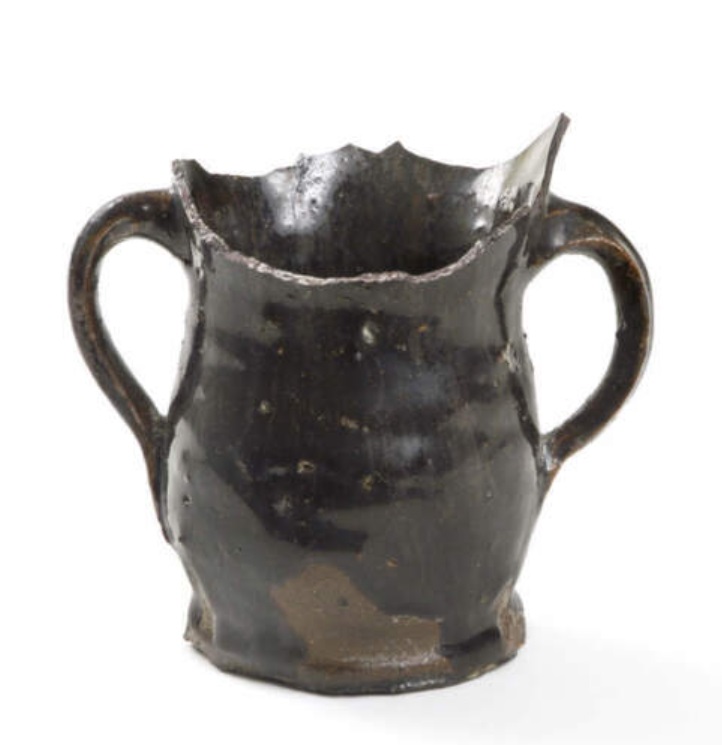
I am lucky enough to own a copy of a Tyg by potter John Hudson, an amazing craftsman who used traditional techniques to faithfully recreate medieval and post-medieval vessels:
Lovely stuff – its 3 handles make it a joy to hold. I have, on occasion, carefully sipped a snifter from its curiously shaped body.
The making of this ware type – with this specific fabric type and in these shapes – seems to have died off by the late 1500’s, but the black-glazed tradition continues.
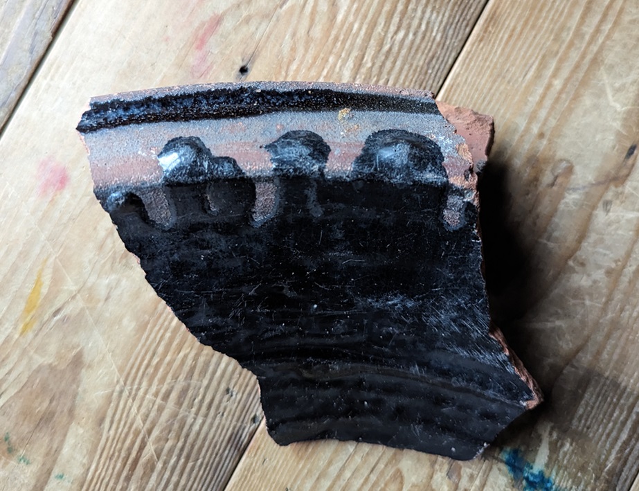
BLACKWARE (aka Midlands Black Ware, Black Glazed, Ticknall Ware, etc. ) DATE: 1550-ish-1800-ish DESCRIPTION: Black shiny glaze over a red or reddish brown fabric. SHAPES: Mugs, Jugs, Tygs, Bowls, Dishes.
This stuff continues the tradition of making pottery with a lustrous black glaze, but without the hard purple fabric. Instead, reddish, reddish-orange, or occasionally buff coloured fabrics are found, and overall it is fired to a lower temperature, making it less hard and more, well, coarseware-y. Often with a small number of quartzite – sandy – inclusions, but normally of a consistent colour throughout.
Fabrics! Multiple colours, and more inclusions than the Cistercian Ware.
The surface is normally much shinier than Cistercian Ware, but can also be found as a metallic looking surface, the result of adding lead in the form of Galena. Often there is an under-glaze slip that provides a red surface which, when covered in the glaze and fired, creates the black surface. This is particularly true in the case of the buff or whitish coloured fabrics such as that in the photo above.
With the light in the right place, you can really see the metallic sheen.
It has been suggested that this was a desired effect; in the poor candlelight of the 17th and 18th centuries it might look like it was made from more expensive pewter. This is a Skeuomorph, an object made from one type of material made to look like it is made from a different material; we’ve encountered it before in the Manganese Mottled Ware pottery. I’ve said it before, but don’t say we don’t learn you nuffink on this website!
Shapes include many of the same type you find with Cistercian Ware – mugs, tygs, jugs, etc. – although slightly more evolved – for example the mugs and tygs are noticeably taller. However, we now see larger bowls and jugs, too. Blackware becomes the utilitarian ware type, and thus it takes on many forms and uses.
To be honest, there is a deal of overlap between Cistercian Ware and Blackware, especially at the beginning, and it is not an exact science. Moreover, it is a good example of problems within post-medieval pottery studies: many different potters are making this stuff, in many different locations all over Britain – the black glaze was very popular, and so there was a ready market. But, 100’s of years later we have archaeologists digging this stuff up everywhere, and mudlarks/tiplarks/fieldlarks finding it all over. But there is no consensus as to what this stuff should be called! And why would there be? It is made everywhere, is found everywhere, and comes in so many different forms. In fact, I only call it Blackware because the last article I read called it that, and I like the name – it is helpfully vague in that it doesn’t rely on a geographical place (Ticknall Ware, for example), or a specific vessel shape (Pancheon Ware), to define it, but it is specific enough to describe what it is. See… fuzzy edges! I’m feeling very uncomfortable… I need a bracer!
The vast majority of the stuff you might find will be in the later part of the date bracket given above – late 17th/early 18th century. Indeed, by about 1720 the Blackware tradition starts to decline, although it probably continues until the end of the 18th century. Whiteware has become the pottery type – white is the new black, and all that – and we see that start of the quest for the perfect white surface that I have talked about before. To be fair, it was dying from the mid 1600’s onwards, with the introduction of the classic post-medieval pottery types – the Manganese Glazed and Slipwares.
Well, I say dying. Actually, and more specifically, the thin-walled vessel Blackware pottery tradition tails off, but it continues to be used on Pancheons.
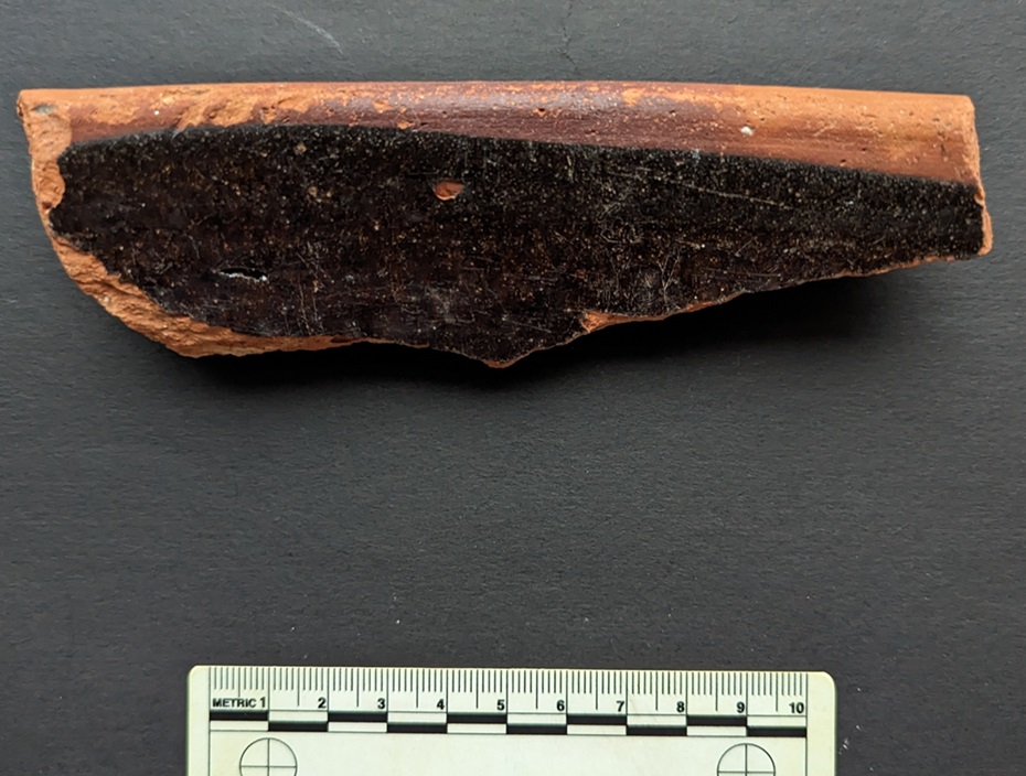
PANCHEON WARE (Coarse Earthernwares) DATE: 1700 ish-1900 ish… emphasis on the ‘ish’! DESCRIPTION: Thick-walled (1-2cm), often reddish/orange coloured fabric, commonly with a black internal glaze, and with a chunky rim. SHAPES: Well, er… Pancheons, but also other large utilitarian vessels: large pots, colanders, chamber pots, etc.
A lovely word, for a great category of pottery – the mighty Pancheon – also described as mixing bowls, cream separators, or dairy bowls. Their purpose is multiple, as their name suggests, but it is their large size that is really impressive, as is the skill, detail, and indeed general lack of care with which they were made and decorated. Into this category we might also add large bowls, large dishes, chamber pots, and colanders. But the commonly encountered type, Pancheons, are generally steep sided open bowl shapes, with a height of up to 30cm, and a rim diameter of up to 60cm, or more. They are big pots, and consequently the sherds, are usually thick walled, ranging in width between 1 and 2cm, and are instantly recognisable.
A complete Pancheon – the word may have been a corruption of Puncheon, meaning a large container of liquid (and possibly the origin of the word punch, meaning a mixed drink).
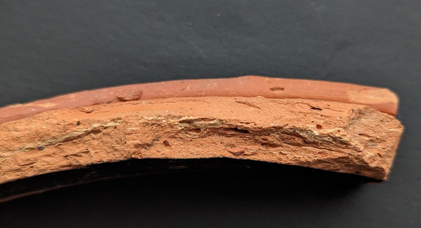
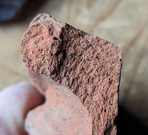
Fabric is normally reddish or reddish brown.
Commonly, though, the fabric is poorly mixed with another cream or buff coloured clay, giving it a distinctly marbled effect.
Very clear marbling in this sherd.
Why this was done is unclear. If it was just a few examples of this happening, we might suggest that the potter was using up some spare clay he had lying around, but it is too commonly found. It can’t have been a decorative reason as no-one would see the fabric unless the pot was broken. I wonder if it was a practical concern, and that the buff clay had different thermal properties, perhaps allowing the vessel to shrink uniformly when drying or during firing? This might explain why it was poorly mixed into the fabric. But honestly… answers on a sherd to the usual address. My feeling, though I can’t be certain, is that this was more commonly found in earlier vessels, and that these mixed clays stopped being used in the 19th century.
Within the fabric are often found small inclusions – sometimes quartzite (sand), sometimes other small stones, and occasionally grog – crushed fragments of pottery. These too have the effect of improving shrinkage during, and strength after, firing.
Vessel rims are very distinctive – thick and chunky, and often square-ish in section, although other forms of rim – particularly those from shallow dishes – are flatter. Again I suspect, but can’t prove (yet) that these are early vessel types, and that by the 19th century the Pancheon takes on a single uniform shape which is made by potters all over the country.
Some Pancheons have handles, and often these are scooped lug type handles.
I love this – you can see thumb marks where it was pressed onto the body whilst wet. But also, you can see scuff marks above, where it was fixed properly and the potter accidentaly left an impression. Rough, and not over produced pottery like this, is so much more human.
Perhaps most distinctive is the black glazed surface. Because these vessels were normally only glazed on the interior, you will only find it on one side. As with the Blackware above, the dark colour was achieved by roughly painting a red slip on the interior and the rim, over which was applied a thick iron-rich glaze which, when fired, becomes the very dark brown or black we see. Sometimes this red slip was applied to the whole vessel, but even then any glaze or slip on the rim or exterior is the result of spillage.
Here you can clearly see the red slip over the orange fabric, and where the glaze has splashed has become black. Also, lovely lovely wiping marks, and is that a fingerprint? A person made those… 200 years ago! *shudder* This is why I do what I do!
That said, sometimes this spillage was a deliberate decorative feature, with the large exaggerated thick drips over the rim and down the outside giving it a certain devil-may-care look.
Lovely stuff!
This devil-may-care look also extends to the interior and exterior surface treatment of the vessels, where they also make use of ‘manufacturing’ marks as a form of decoration, thus you can see deep grooves and ridges on the interior and exterior where the clay has been pulled up on the wheel, and roughly made smoothing marks on the exterior.
Groovy! What? It made me smile…
Indeed, overall they seem to be very roughly made, with little attention to ‘perfection’ at a time when pottery was fast becoming quite literally an art form. I suspect that this is in part due to speed being the essence in making them, combined with the fact that they are entirely practical with very little attention paid to decoration. Even the fact that they are glazed on the interior only is suggestive of their practical nature – it’s quicker to glaze only one side, and it is cheaper, but it is also not necessary to glaze the exterior as only the interior needs to be waterproof. However, I also think there was a decorative element to the roughness – the exaggerated drips, the course smoothing, the noticeable finger and thumb marks in the wet clay and slip. I like this, it adds character and a human element.
Deliberate grooves on the interior and exterior of these vessels.
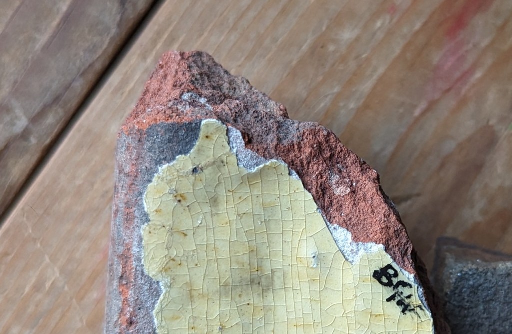
Now, whilst most sherds you will encounter are Black glazed, within the broad category of Pancheon Ware are sub-types, with different coloured exteriors – namely Brown, Yellow, and Pale Yellow/Cream.
A massive chunky rim sherd… from my back garden!
Actually, the colours depend on the amount of iron in the glaze and the colour of the surface underneath, but it is all the same process. It works like this: the more iron you add to a glaze, and the darker the surface under the glaze, the darker colour the pot will fire. And conversely, the less iron you add to the glaze, and the lighter the surface under the glaze, the lighter the finished pot will fire. So the Yellow glazed sherds often have a white slip and a glaze with little iron in it, and the Cream, too, but with a glaze that has even less iron added to it.
You can clearly make out the white under-glaze slip covering the naturally red clay where the glaze has peeled away. Ignore the writing, that’s a code I use in my reference collection (which is kept separate from the main ‘Pile o’ Pottery’) to tell me where it came from: BGW = Back Garden Wall. Here we can see where the glaze has run over the white slip and onto the red fabric, producing the brown stripe. Now imagine if the fabric was a darker red, or had a red slip… it would produce a black glazed surface.
Brown has a darker coloured red fabric or a red slip, and an iron rich glaze, but not as iron rich as the Black glazed surfaces.
The truly wonderful Bingham Heritage Trails Association, who have done an amazing amount of work on post-medieval pottery (a very much recommended website full of pottery), have given them different names, and put them in a tentative chronological order, depending on fabric types and surface colour. This might work, but I’m not 100% convinced, and I think the differences maybe have more to do with desired colour, geographical origin of the clay, and our old friend fashion, than the date it was made. Essentially, any colour/surface treatment could have been made at any stage between 1650 – 1900… ish. I am always happy to be wrong, though – its the story of the pottery that matters.
The fact that Pancheon fragments crop up everywhere is both testament to their popularity – at one stage everyone seems to have had one – but also their large size; there’s simply more of it, so when they break up, they produce many more sherds than, for example, a smaller plate would.
Overall, it seems that Pancheons – and indeed all of these large domestic vessels – stop being made, or at least stop being popular, at around 1900 (although I’m sure many would still be in use from then on). Why is unclear, but it may simply be that the large clunky vessels were impractical in most kitchens, particularly in the cramped interior of terraced houses in the cities, and so they fell out of favour.
Our final black glazed pottery type is…
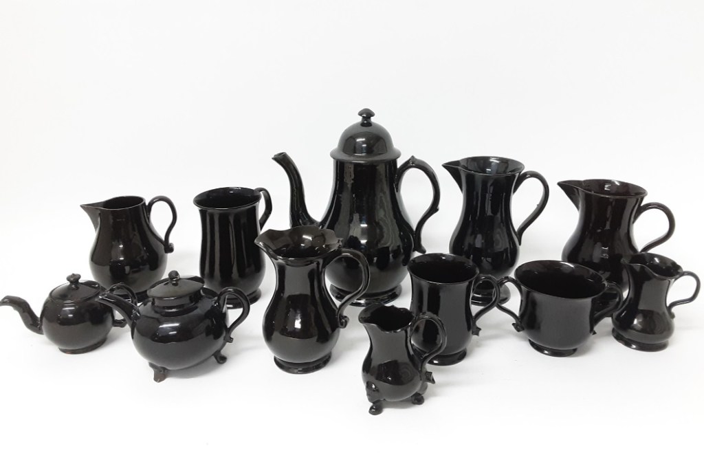
JACKFIELD WARE (aka Shining Black) DATE: 1750 – 1820-ish DESCRIPTION: Very shiny black surface on a red earthernware fabric. Often has handpainted white decoration. SHAPES: Very tea/coffee focused, so teapots, coffee pots, sugar bowl, cups, jugs, mugs, creamers, etc.
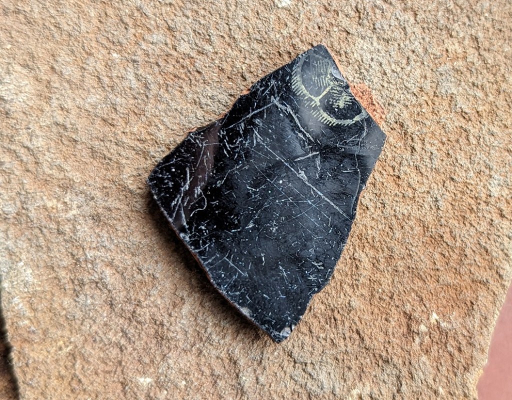
Not common at all (I only have one sherd!), Jackfield Ware is a refined earthernware that was popular for a short period in the late 18th century, and was focused on the consumption of tea and coffee, incredibly fashionable at that point in time. It reproduced all the essential elements of the black glazed tradition, but did so to an almost perfect finish. It is named after Jackfield in Shropshire, where it is known to be made, but the majority seems to have been made in Staffordshire. I have to say, this stuff is almost impossible to identify as a single sherd – it looks very like all the others, perhaps just a bit finer. If it wasn’t for the painted decoration on this example, I wouldn’t know I had any at all!
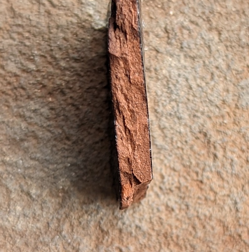
Fabric is red or a reddish brown, hard fired, with almost no inclusions – it is refined, and dense, and the vessels are thin walled.
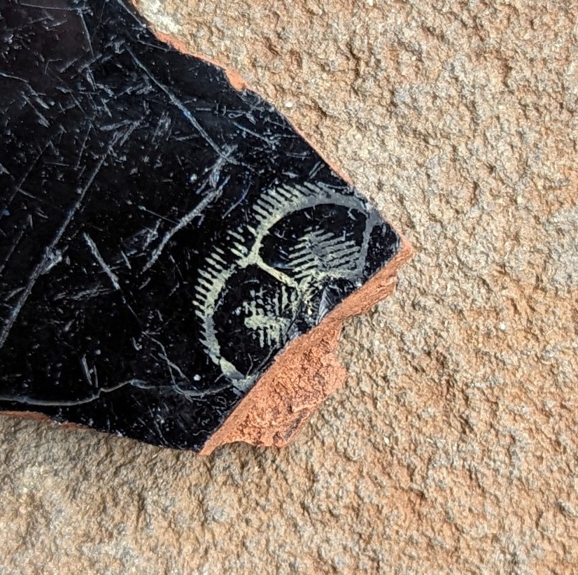
The surface treatment is a uniform black glazed interior and exterior, with the glaze being particularly shiny – almost metallic – probably due to a high lead content. Honestly, you can see your reflection in this stuff. There is often sprigged decoration (a separately moulded clay three dimensional design stuck on the outside – often, in this case, floral designs – flowers, grapes, etc.), but commonly there are hand painted designs. These images were painted after the vessel was fired – over-glaze decoration – as contemporary under-glaze paint wouldn’t survive the firing process. As a consequence they often rubbed off, and exist as ghost-like images, especially in the kind of sherds that we find.
A flower design – I really like this. You can also see how it would wear away easily.
In terms of manufacturing, you can see the grooves where the potter pulled the clay up, but only on the interior wall where it wouldn’t be seen – this is fine pottery after all – whilst the exterior is super smooth, and is usually turned on a lathe to produce a perfect finish.
Shapes, as I say, are dominated by tea and coffee consumption, so commonly there are teapots, coffee pots, and cups.
The cups are more like those we would recognise today in that they have only one handle, rather than the multiple handles of the tyg – a design development. This is the start of modern pottery… raise a toast with your next cup of tea!
And to end with, a broad description of Midlands Purple Ware, a slightly coarser version of the fabric that Cistercian Ware is made from.
MIDLANDS PURPLE WARE DATE: 1400-1700 ish DESCRIPTION: Hard fired coarsish pottery, purple-brown/grey in colour. Coarse surface, normally slipped with wiping marks. Occasional internal dark glaze. SHAPES: Large open vessels, bowls, urns with spigot hole, salt pans, butter pots, rarer in small vessels, cups, mugs, etc.
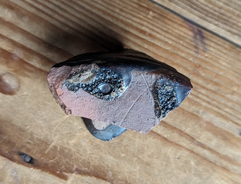
Not commonly encountered to be fair (I only have a single, if large, sherd), but it is occasionally found in small quantities on early sites, and is part of a story. Midlands Purple straddles the period between the medieval and periods wonderfully, and takes elements of both.
My only sherd of Midland Purple Ware. Mind you, it’s a biggun!
Made in the same potteries and kilns as Cistercian Ware, and indeed the larger Midland Purple vessels were sometimes used as Saggars (a protective ‘box’ within a kiln) for the smaller and more delicate Cistercian Ware vessels. Thus we can be sure that the two ware types were contemporary, and Cistercian Ware seems to share the fabric type – that is, both ware types are made using the same clay, and fired at the same temperature, to produce a very similar type of fabric.
Purple, reddish purple, or greyish purple in colour, the fabric is hard fired, almost vitrified, with numerous voids, and has numerous quartzite inclusions, often with a black and white “salt and pepper” like colouring.
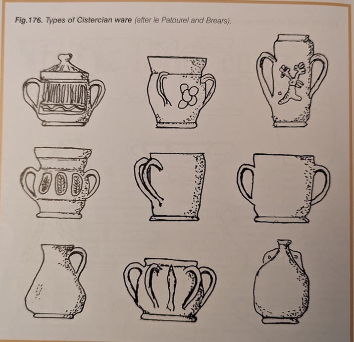
The surface is purplish, greyish purple or a browny purple, and is usually slipped, or simply smoothed, and smoothing marks are normally visible. The inclusions also poke though this slip, giving the surface a coarse feel. Rarely it is glazed on the interior, and these are normally found on butter pots, used to export butter into the big cities, notably London. A common shape is that of a jar with a reinforced bung hole just above the base, and these are often associated with domestic beer making, with the holes taking a spigot. Shapes include jars, butter pots, storage jars, jugs, pipkins, bowls, mugs… in fact a huge range of vessels, but the large jars and butter pots are the most common.
Midland Purple Ware shapes.
Traditionally, MPW is though of as dying out by the late 17th century, when it’s role as the hard-wearing utilitarian pottery type was probably overtaken by the aesthetically more pleasing Brown Stonewares.
So there we have it, Part 10. I’m pretty sure people who have spent long years studying one type of black glaze from a single pottery workshop are currently forming angry mobs, complete with lit torches and pitchforks, to seek me out, but I hope it helps.
The bad (good?) news is there’s only two more parts to the Rough Guide… Finewares and “Things That Might Be Pottery… But Aren’t”. The good (bad?) news is that I’m going to try and edit this guide into a Where/When Special booklet or zine, so that you can take it with you when you go Wandering. I know, I know… you can’t wait.
More very soon, as I have some big announcements! *Cough Wanders-a-plenty *Cough… and more.
Until then, please look after yourselves, and each other – just a quick check in with the neighbours, or even the person serving you in the shop, can make all the difference.
Nope, no pottery today. Instead we have tracks. And stones. And holes. Look, just read on… it’s simpler.
Now, I do love a good track. Ask anyone who knows me, and they’ll say “why yes, that ruggedly handsome, wonderously whiskered, and all-round splendid chap does indeed love a good track or two“. I also love a good stone. In fact, ask anyone who knows me, and they’ll say “why yes, that marvellous man, that genius gentleman, that… ” What’s that? What do you mean “get on with it!“? Honestly.
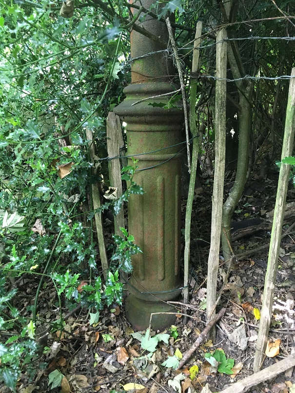
Ok, so several years ago I noticed that dotted around the Glossop area are a number of standing stones that have holes carved in them. I did wonder about them, but presumed they were a form of gatepost, even if they didn’t seem to be in a place one would expect a gatepost.
A holed stone on Hague Street. They remind a bit of Hattifatteners from the Moomin stories… they probably come to life at night.
More recently I have been looking at tracks:
TRACK (noun) A rough path or road, typically one beaten by use rather than constructed.
And more specifically, the old – medieval or post-medieval (10th – 17th centuries) – trackways that dotted the area. Glossop is a great example of what we call a medieval ‘dispersed settlement’ – essentially, whilst there is a central focus – Old Glossop, with the church and market – most people actually lived in the many surrounding ‘dispersed’ farmsteads – Heath, Dinting, Ashes, Jumble, etc. People came together every Sunday for Mass, as well as other feast days and holy-days, for market days, as well as socially – for a drink in the tavern, for example. But by and large, Glossop in the medieval and early modern periods was dispersed throughout the valley in farmsteads. In this instance, a farmstead may be understood as a farmhouse and associated buildings – barns, shippons, and various ‘farm-ey’ outbuildings – as well as houses for the farmworkers. In total, we’re looking at perhaps 20 people or so for a larger farmstead, maybe 5 for a smaller. Of course, people need to travel, and roads were made through the landscape, connecting these farmsteads, and it these I incredibly interesting.
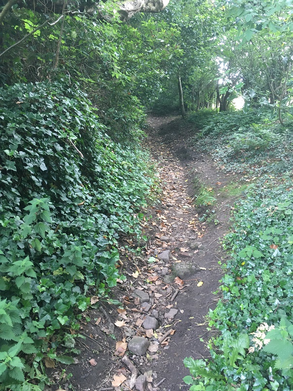
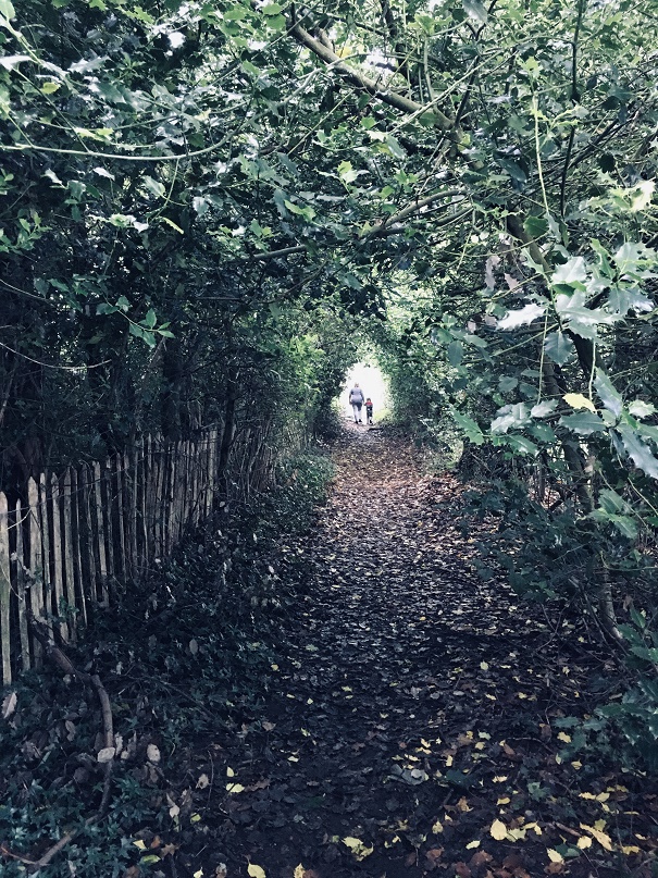
This is the track that runs down from Ashes to Dinting – once the main thoroughfare, now a beautiful sunken trackway, or holloway as they are known, its age is shown by its depth, worn through use.
They were not just a means of physical movement through the landscape, but also a conduit for other aspects of life. As packhorse routes (no horse and carts here, just heavily laden beasts of burden) they connected everybody, and allowed goods and produce to move between places and markets. News of the wider world also moved along these tracks – a new king or a new religion, or news of battles and wonders in far off places. But so did disease and infection; the Black Death and Great Plague once walked these tracks. We also encounter the more local and personal aspects of life, too: newlyweds from church, newborns from baptisms, and the final journey from the farmstead to the church yard, as the deceased was carried for burial, often for miles, along the tracks, followed by mourning family and friends. All of life is contained in a track, worn deep by use, and all of history held there, if only we could access it.
However, the collision of stone and track didn’t connect until last year, when it occurred with an audible click at Pyegrove.
Pyegrove circled in red. For orientation, the Snake Pass runs horizontally across the bottom, with the Commercial Inn on Manor Park Road circled in blue on the right, and the Royal Oak, left. Note the green arrow. Map from the marvellous and incredibly useful National Library of Scotland map website – well worth an explore.
An afternoon playdate with Master Hamnett and his friend led us to Manor Park via Pyegrove. Now Pyegrove is an interesting corner of Glossop, with a long history; the name means the copse or thicket’ (grove or greve, as it is in older maps) of the magpie (the ‘Pie’ or ‘Pye’ element) which suits its location below Shire Hill perfectly. The house here has a datestone that reads “I.M.A. 1747” (no photographs, alas… it’s difficult to even see it without overtly trespassing), so that the house is at least that early. However, in the baptism record of a John Shepperd at Glossop on Christmas Day 1735, his father (Robert Shepperd the Younger) gives his address as Pyegreve, so we know something else was there at an earlier date. Pyegrove is, I suspect, another medieval farmstead… but all that (along with tales of Buffalo Bill) is for another time. Let’s return to tracks and stones.
The footpath at Pyegrove splits – right skirts Shire Hill down to Mossy Lea, left ploughs on over the playing fields to Glossop.
Tarmacked, unlike the original, choose your path wisely.
But just at the split I noticed this:
Oooooh!, thought I – a holed stone…
It was at that point it suddenly struck me, and as I stood there gasping like a stunned fish, ignoring the children, and mentally ran over all the holed stones I knew about (5 at that point). Of course, I thought, they all marked a junction in a footpath or track! And all of those tracks, I was fairly certain (and am now convinced) were the preservation of early (medieval or post-medieval) trackways between farmsteads. I have talked about this before – the fossilisation of early trackways, preserved as footpaths within modern settings, but in essence once the newer – and much better – roads were constructed for the mills (1790’s onwards), these old roads fell out of use, but as they often were more direct, and were known by locals who still used them, they gradually became public rights of way.
The stones, being big and heavy, are often not moved, so there they sit as testament to the tracks that were once the main roads between the dispersed settlements that made up Glossop. I know of 9 holed stones now (and two more that might be relevant), and looking closely at the stones, they all share similar aspects. Upright, and roughly shaped from millstone grit or similar gritstone, and they seem quite worn – usually an indicator of age. The hole, made through the stone, is broadly square in shape, measuring between 3 and 4 inches across, roughly carved, and placed in the top third of the stone. I am convinced they were shaped and set up by the same group of people to make using the notoriously bad road system around Glossop easier. Of the stones, the obvious question is why does it have a hole in it? My first thought was that it would mark the stone as different from others that might be in the area, making sure that a junction wouldn’t be missed in the dark or bad weather. This might be the case, but then I remembered reading that in 1693 a law was passed that trackways had to have a guide post showing destinations (the Whitfield Guide Stoop was a result of this law, but probably a later incarnation), and I wonder if the hole was there to allow a wooden sign to be placed in it with destination painted or carved on it? Or perhaps a simple stick pointing the way? Any thoughts on this, o’ wonderful readers? I also wonder how far this tradition continues – certainly I know of no others in surrounding areas – even Tintwistle or Hadfield, for example, seem to have no holed stones, although I’m happy to be proven wrong. .
But let’s have a virtual explore the Pyegrove to Glossop track here, starting at the stone that started it all.
Ignore the later drilled circular hole, and the rusty bolt through the hole – this is a classic junction marker, with its ‘square’ hole and rough shaping.
Ignoring the A57/Snake Pass (opened in 1821, although bits are older), behind us is what is now Derbyshire Level, with the farmsteads of The Hurst, Jumble, and Gnat Hole, and also the road to Whitfield and Chapel en le Frith. Going left, then, a track along the edge of some houses leads out into Pyegrove Playing Fields.
Looking back at Pyegrove, the overgrown track hides what was once a main thoroughfare into Glossop. O’ for an excavation of this track!
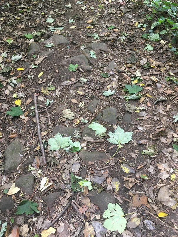
Along the northern edge of the playing fields the track is no longer used, but is visible as a ‘holloway’ – a track worn deep with use.
Here is the Holloway, Green Way, or sunken trackway, depending on how you call it. Do you known what, it’s oddly difficult to photograph a dip in the field, but it is there… honestly!
We join the track again at the corner of the playing field, where there is a lovely squared off standing stone.
A simple standing stone, if such a thing exists.
This seems to mark the junction of a track that originates at Cross Cliffe, here marked in blue:
The trackway is visible in the older maps, and although it fizzles out on the ground, it is preserved in field boundaries and fossilised in strangely preserved bits of pathway.
Whilst it is just about marked on older maps, it is no longer in use, although its memory is fossilised in this bit of unnecessary and unusually wide stretch of pedestrianised path leading from the Snake Pass to Pyegrove Park (marked with a red circle in the above map)
Oddly wide, and completely unnecessary, this is the fossilisation of an older track from Cross Cliffe.
These simple – unholed – standing stones sometimes mark junctions, but more normally simply mark the line of a path where is might not be obvious, particularly in the dark or rough environment (I know of about 12 of these, too).
We continue along our Pyegrove track beyond the stone and past the remains of the Royal Observer Corps station. Briefly, the station was meant to monitor potential enemy aircraft in the immediate post-WWII period, but it would also serve as a monitoring post, observing and recording the effects of any nuclear detonation on Manchester – wind speed, radiation levels, blast radius, etc. This is why it is built into the hillside, 15ft below ground level. A sobering thought, and one sadly now relevant once more. This will also be the subject of a future blog post, don’t worry!
An interesting slice of much more modern history, but one that is certainly worth a look at .
Back to the task in hand, and on to another standing stone. This one, looking for all the world like a gravestone, was originally one of a pair (its partner is embedded, horizontally now, in the wall.
One of a pair – the other can be seen lying horizontally built into the wall – same stone type, same width, same depth, and presumably the same length, accounting for a few feet underground.
These gravestone pairs are usually found mid track or at the start of junctions, and seem to be a later addition to the tracks (probably post-1790’s) and seem to be an attempt to force packhorses and traffic onto the newer roads (and presumably so they can pay the tolls) – and early form of traffic calming, if you will. I am fairly certain with the date of c.1800 as Whitfield Cross was used as a partner to one of these ‘gravestone’ pairings after it was moved in about 1800. There is some graffiti carved on the top of this stone – ‘G.B.’.
G.B. step forward and take a bow – I do like a bit of carved graffiti.
From here we continue, round the corner, to the farmstead of Hall Fold.
Converted barn and outbuildings of the farmstead of Hall Fold
A datestone here records ‘J.S.J. 1806’, but this was apparently found when the owner was digging a foundation, and clearly Hall Fold Farm is older that that.
Not my photo – stolen shamelessly from the Old Glossop website, which has a bit of history and a series of very interesting photographs of Hall Fold Farm – here.
The name itself may refer to a long demolished, possibly medieval, original Glossop Hall (Manor Park Road was once known as Hall Street). This is also the location of a junction – our track is joined from one that comes from Whitfield (an extension of this one).
A fork in the track!
Our track from Pyegrove is on the left hand, but the one from Whitfield comes via Old Glossop Cricket Club, and would have come through the gates ahead. Though no longer in use, its presence is preserved in field boundaries and the fact that these houses (c.1830’s) respect the track, which is why they are built at that strange angle. It’s also visible in LIDAR under the cricket pitch.
Sadly, no marker stone remains at Hall Fold Farm (although I didn’t start poking around people’s gardens, and it may well be lurking somewhere – large stones are hard to completely lose). From here, the medieval centre of Glossop is a hop, skip and a jump… if you are feeling so inclined.
I have to say, though, walking into Glossop this way is a much more interesting – and authentic – experience, and one that is very different from walking along Manor Park Road! We take our modern roads for granted, and I’m not going to lie – the idea of moving along these tracks in bad weather and in darkness fills me with fear.
This is a small part of a much larger project I’m working on, tracing these tracks all over Glossopdale. Each of the settlements that make up ‘Glossop’ – from Wooley Bridge in the west, to Pyegrove in the east, Tintwistle at the north, to Chunal in the south – have multiple tracks linking them, and for the large part they are still there, often hidden, occasionally ‘fossilised’ as footpaths, or even still in use. This is truly an overlooked, and indeed largely undiscovered, aspect of Glossop’s pre-Victorian/pre-Industrial history, but one that was vital to its development. And I have to say it is great fun being able to walk these ways, and pondering the history they hold – if anyone fancies joining me, give me a shout. Also, and this is a serious request, if anyone knows of any holed stones (or any standing stones, for that matter) that I might not know about, please do get in touch – often half hidden in hedgerows, they will lurk where two or more tracks join.
Right, that’s all for now. More pottery next time (did anyone else hear that high-pitched screaming sound?), but until then look after yourselves and each other, and I remain,
As I have said many times before, I do love alliteration. What ho! and all that. I trust you are all keeping well in these odd times? Well, now this is a monumental post – it is precisely three years to the day that I made the first post on this blog (you can read it here if you want). When I first started it I had no idea what it was going to be, other than I had some interesting bits and pieces that I wanted to share, and which I thought other people living in Glossop moght be interested in. The blog is still pretty much that in aim – bits and pieces – and I was right… there are lots of you out there who seem to enjoy the ramblings of a man who gets excited by bits of old rubbish. So thank you, you wonderful people, for reading, and here’s to many more blog posts. Now, on with the show. RH
During the lockdown, Master Hamnett and I have been taking a daily constitutional up and around what has become known as the “secret passageways”. Overgrown and wild in places, even for a man of modest size such as myself it is a mysterious place, but to a 4 year old it is indeed another world. Naturally, I have been keeping an eye open for bits and pieces of history, and I think I have a story to tell. Possibly. Well, I certainly have some pottery to show, so there’s that!
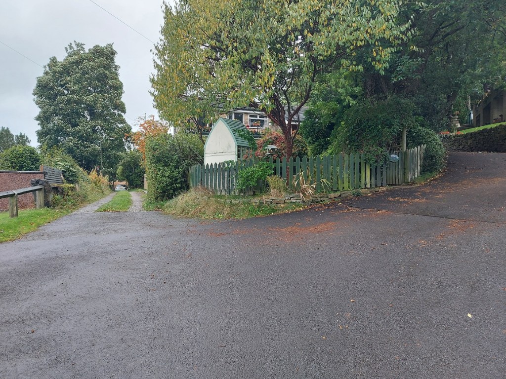
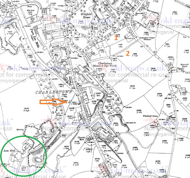
The route we walk is essentially along Hague Street, down one track to Charlestown Road, along, and then up another back to Hague Street. We often continue on and round if it’s not raining, but always walk these paths, which I have helpfully marked Tracks 1 and 2 on the map below:
Tracks 1 & 2 at the top. Ignore the arrow and a circle for now… all will become clear!
The tracks and immediate area are more clearly shown on the 1968 1:2500 map
It’s a nice and short circular walk, if anyone fancies it.
The tracks are interesting in themselves in that they are once again an example of what I call the fossilisation of trackways – they are older tracks that no longer perform a function as such, but are preserved as footpaths. Certainly in this case as it makes no sense to have two tracks mere metres apart going between the same places. Instead, I think they are preserving the memory of a single older track, which I suggest below is Track 2, potentially the more interesting of the two. But I’m getting ahead of myself.
Track 1 runs down the side of this house, which was originally a pub called the Seven Stars (hence the sign on the door frame, although the sign above the door is a mystery… if you are reading this and own the house, could you tell us?).
The one-time Seven Stars pub – I always feel a bit weird photographing people’s houses, but this is visible from the road, so it’s not as though I’m sneaking around gardens.
I know nothing about this establishment, but it was probably a beer house. As a reaction to the widespread and dangerous consumption of cheap gin – the so-called ‘Gin Craze’ of the late 18th century – the government encouraged more beer drinking (beer being considered relatively healthy) by allowing householders to open up their houses to brew and sell ale. These private houses became known as beer houses, and the individual paid a small fee to the local magistrates in return for an annual license allowing them to sell beer, but not the wines or spirits that the normal pub or inn could. If anyone has any information about the Seven Stars, please do get in contact.
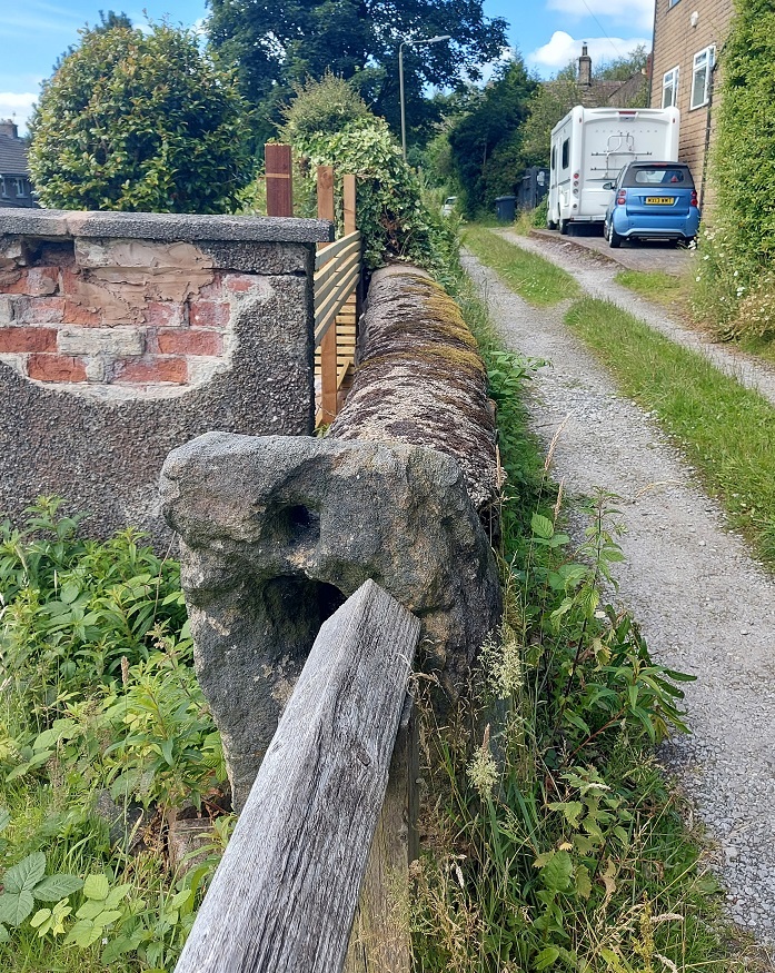
Just here is a series of upright stones presumably placed to stop horse riding or cycling. The gap between them is very thin; I might have put on a little weight during lockdown, but even I had to squeeze through.
Breath in!
Carved onto one of these uprights are the intials ‘M.D.’ – I must have walked through these 100 times and never noticed the letters before, but the light and the rain were just right this time.
And as you all know by now, I can’t resist carved graffiti.
Further down the footpath I noticed a reused quern or grind stone – possibly Victorian, but I suspect earlier – being used as a coping stone for the wall. And why not? It’s the perfect shape, and may well have been hanging around for centuries after being used to grind wheat into flour.
The worn central hole is visible, and it’s possible the other half is around here somewhere.
About halfway down, you come face to face with more of those upright stones, although in this case I can only assume they were put there to stop a headless horseman! Honestly, they are quite unnerving.
Not at all creepy and gravestone looking. Nope. Absolutely not.
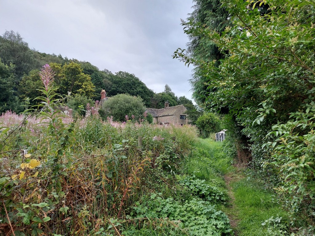
The path continues:
Master Hamnett on the final stretch down to Charlestown Road. At the end of the path, in spring, there is a truly spectacular spread of wild garlic.
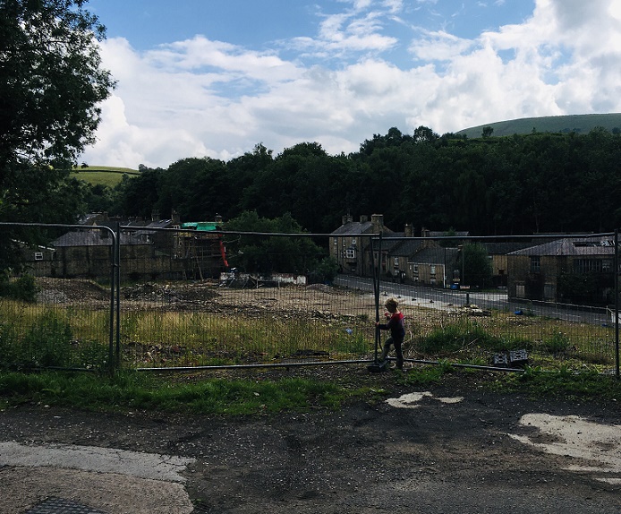
Until we arrive at Charlestown House, and the Charlestown Works that were – now demolished and awaiting houses.
The site awaiting re-generation. The hairpin bend where Charlestown Road meets Turnlee Road is visible. Whitley Nab in the background right, Casa d’Italia left (very nice pizza, highly recommended). Dead ahead is Lees Hall, which is important… stick around!
So, here’s the pottery:
A small assemblage of fairly typical Victorian bits, with a potentially earlier piece.
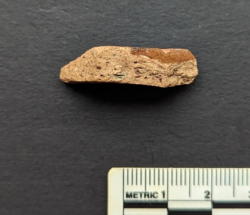
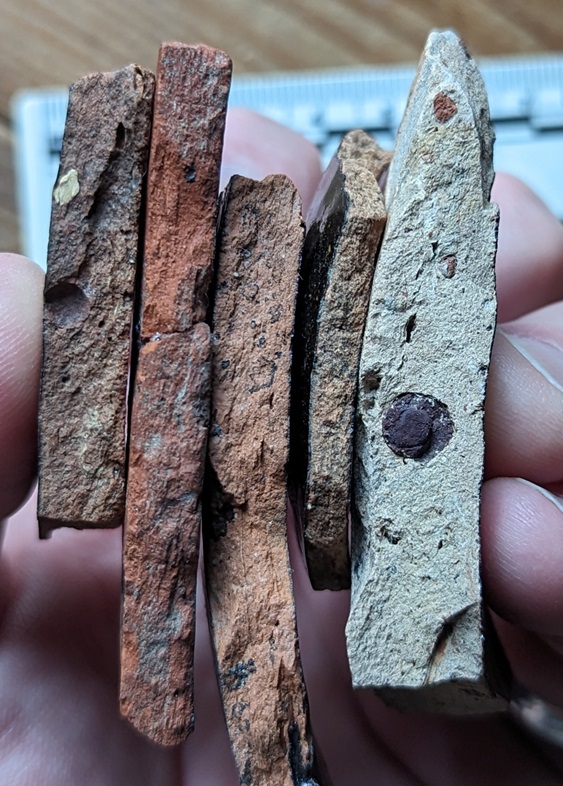
Top row, from the left: a base of a saucer or small plate; a huge chunky handle belonging to a large jug; a base of a glass jar or jug, or possibly from a tankard – it’s nice and decorative, but not expensive. Next is a fragment of a pedestal footed drinking cup, which is again fancy, but not especially expensive, it being just glazed earthernware. Then there is a rim to a large plate of some sort, being about 30cm in diameter.
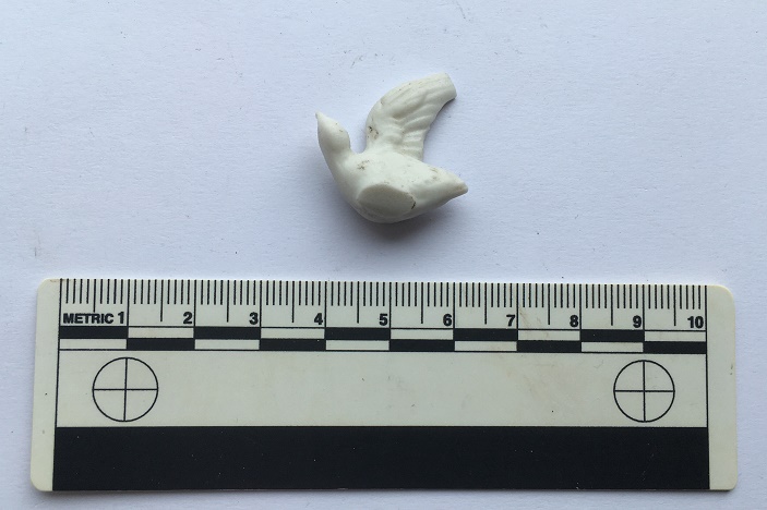
The lower row from the left: a fragment of a stoneware bottle, a chunk of a pancheon, and a fragment of a manganese glazed jug or similar thick walled vessel. Then we have two pieces of blue and white earthernware, and a base of a tea cup. There is nothing massively interesting, and it all seems to be Victorian in date, as we might expect… except for the manganese glazed jug! This is, I think, earlier – perhaps early 18th century. It’s quite characteristic, and although there was a revival of manganese glazed pottery in the Victorian period, this glaze is of relatively poor quality, and the fabric (the actual clay of the pot) is quite rough, both of which suggest an earlier date. Then there is this lovely bit of pot; it’s a china dove, shaped to fit onto what would have been a tasteless Victorian jug or bowl – you can see the flat bit where it was joined to the vessel it flew away from.
Found lurking below some dandelions.
Then there was this:
A bottle top
A screw bottle top, probably from a beer bottle or similar, and dating to the early 20th century. I love these things, and have blogged about them previously – here, for example. Unusually, this one doesn’t have the drink makers name or logo on the top, just the name of the bottler – R. Green of Leigh.
Always nice to see.
Moving on to Track 2, there is a noticeable difference between the two. This one is more of an actual track; it is certainly wide enough to drive a horse and cart down it, and it seems to have had a surface at some stage. It is also deeply worn in places, which can be suggestive of an older trackway.
Possibly worn by traffic, the track is quite deep in places.
It’s not much to look at, but this is the surface of the track.
I’d love to put a trench across this track to see how it was made up.
Further on, it has what seems to be a late 19th or probably early 20th century cast-iron streetlight, which is interesting and spookily out of place now, but suggests strongly that it was used as a ‘proper’ track until fairly recently.
It has seen better days, but there it is, slowly being overtaken by nature.
I can’t work out if it is gas or electric… further research is needed.
Right next to the streetlight is a gateway into a seemingly random field, and a benchmark on the gatepost – it’s been a while! This one – 616.77 above sea level – is a late addition as it is only marked on the 1968 1:2500 map. There was another benchmark marked on the opposite side of the track – 622.6ft above sea level – but it’s long gone (you can see it in the map above).
The bench mark. This is what 616.77ft above sea level looks like.
The track continues until daylight is reached.
I love this shot… artful (courtesy of the iphone filters, not talent on my part). Mrs and Master Hamnett providing the scale.
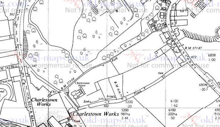
The top of the track, where it joins Hague Street again, is the site of the original Whitfield Methodist chapel – it is visible on the 1880 1:500 OS map:
The chapel is clearly marked.
Built in 1813, it had seating for 200 worshippers, and at one time was the home of the pulpit from which John Wesley had preached in New Mills (as discussed in this post). There are more details about the chapel on the Glossop Heritage webpage.
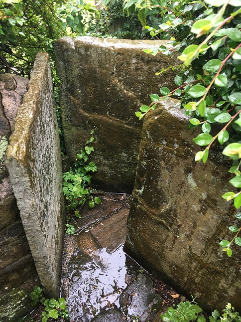
It was demolished in 1885, and the site is now occupied by a private house, but there are some interesting re-used stones on the trackway which almost certainly came from the chapel. The one indicated by the arrow in particular seems to have been a window frame – originally it would have laid upright, and you can see where the wooden frame was bedded in, and possibly a cross bar set into the stone.
I love Microsoft Paint!
A closer look reveals what might be a mason’s mark. Possibly… but then I really rather badly need glasses.
Squinting, after two glasses of wine, and with the eye of faith…
So then, the pottery:
Fairly standard stuff, but still nice.
Top row, left to right: a fragment of a large stoneware vessel with a cream glaze. I have photographed it showing the interior – it is roughly finished, and you can see wiping marks, and it probably came from a large cider flagon.
Next is an annular ware bowl or similar type, with the characteristic horizontal linear bands around the rim and below. Abrim from probably the same vessel is above it. Despite it looking 1950’s, this stuff ranges in date from the mid-18th century to the late Victorian; this is, I think, early 19th century. Next is a sherd of a cream ware jug, this being a part of the spout – you can tell by the twisted curve of the rim – again, early 19th century. Next is a stoneware flaring rim to a large jar, Victorian in date. Next we have a sherd of black glazed pottery which, I think, might be 18th century in date – the glaze seems to be lead based, which it isn’t in the Victorian period, and the fabric is very red, which is also common in Black Ware of the 18th century. I’ll post some more about this in the future – I’m actually trying to put together a crib sheet for pottery identification for this part of the country which some of you might be interested in (I know, I know, stop groaning… you don’t have to read this blog, you know. And I did say ‘some of you‘!). Beyond that is a fairly uninspiring selection of Victorian sherds at which even I pale!
Track 2 is odd – there’s summat rum about it. It has the air of a deserted roadway that was once of some importance, certainly important enough to have a substantial gateway and a streetlight on it. Looking at it, and thinking about the fossilisation I talked about above, I wonder if this was the line of an earlier track, perhaps even the medieval road that led from Whitfield to Lees Hall (which is circled in green in the first above – see, I told you it would all become apparent!). The hall, though 18th century in date now, stands on the site of a medieval manor house, possibly even the original manor house of Whitfield mentioned in the Domesday Book. It was certainly important in the medieval and early modern periods as the seat of the Manor of Glossop, where tax and tithe from Glossop and Whitfield was taken – first to the Earls of Shrewsbury, and then, from 1606 onwards, the Howards. The road from (Old) Glossop came through Cross Cliffe (discussed here), along what is now Cliffe Road through Whitfield, and from there down this track to Lees Hall. One less obvious part of it may be the footpath indicated by the orange arrow in the map above; I don’t think that it is the exact route the track would have taken, but it again ‘preserves’ the way in the landscape. I would suggest, then, that Track 2 is either this hugely important road fossilised into the landscape, or it broadly follows the line of that road which no longer exists. A point that may also support this is that on the 1968 OS map, also above, the track is marked by a series of ‘Boundary Mereing Symbols” (they look like lolipops – circles on sticks) which apparently indicates that it is the boundary of a parish or parish council (here, for an explanation). Boundaries, or meres, often use ancient and established objects or features to lay out the area that is bounded – an old track is a very common and perfect example of this type of feature.
This part of Glossop – I suppose technically Whitfield – is very interesting.
Right, that’s your lot for today. As always, please feel free to comment – even if it’s simply to tell me I’m talking out of my hat. I have more that I am picking away at, but until then stay safe and look after each other. Oh, and happy anniversary.
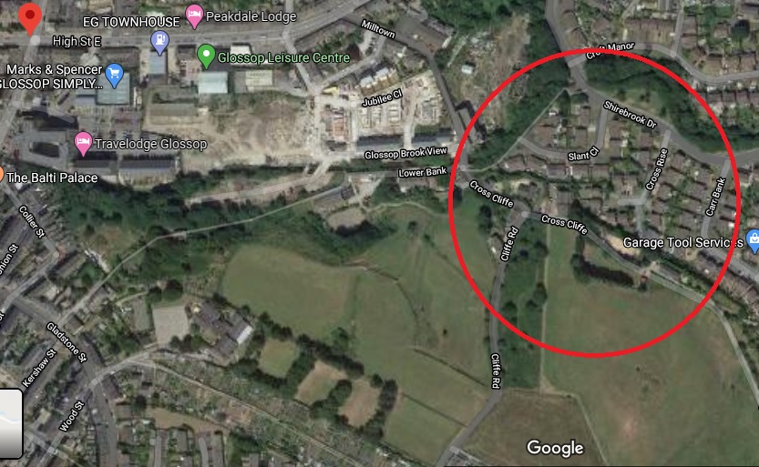
So, hopefully you all read the last post. And even more hopefully, it made sense to some of you. Ignoring the fact that the main point of writing it has been proven to be wrong, I mentioned in the post that I think there was once a crossroads at the bottom of Cliffe Road. Well, let’s concentrate on that! It’s just a t-junction now, where Cliffe Road joins Cross Cliffe (the road to the right), and continues down to Volcrepe and Bank Street (left)
The site of the possible crossroads, and of Cross Cliffe Cross.
But originally, I suspect, it would have gone straight on, right up to the bridge that crosses Hurst Clough – like this:
The photo above shows the area circled in red, the proposed road is shown in green. The footbridge is noted on the map as FB.
However, the whole area has been monkeyed around with pretty seriously, with the main culprit being the building of a Cross Cliffe Mill on Hurst Clough there, as you can see very clearly in this map:
The 1880 1:500 map shows both the mill and the projected route of the track. Interestingly, there is a gas lamp post marked at the junction.
So then, Cliffe Road is at the bottom, and Cross Cliffe runs to the right. My contention is that Cliffe Road once also continued on to the footbridge at the top of the map, and from there on to (Old) Glossop. Let me walk you through it.
Cliffe Road is the original medieval (and probably earlier) track that led from Hayfield down to Old Glossop (discussed HERE), and on which, at the junction of Whitfield Cross, stood the Anglo Saxon stone cross of Whitfield. Beyond this, it continues to what was originally a crossroads.
The crossroads circled in green, with the arms shown roughly in red.
This crossroads was the junction of Bank Street (The Bank, coming ultimately from the Simmondley area), Cross Cliffe (the road leading to… well, I’m not certain, yet.), Cliffe Road (from Hayfield), and the track to Old Glossop heading north. But with the building of the mill in the early 1820’s, and specifically the mill pond, the old track was destroyed, pushing traffic further back toward Bank Street, and then along what became Volcrepe and Milltown, and giving us the kink in the road.
Clockwise from bottom left: road down to Bank Street and now Milltown; Cliffe Road; Cross Cliffe; er… a hedge! The now blocked northern arm of the road.
Although the northern arm of the crossroads is no longer there, there is a path way preserving the route running to the right of the houses and leading down to the bridge.
The path beside the houses, preserving the memory of the trackway down to the bridge.
The original track lead down to a crossing over the brook there. It is now a modern concrete modern footbridge, but is clearly shown in older maps, and is thus presumably an older brook crossing – whether by bridge or as a ford.
The bridge over Hurst Clough, standing in Whitfield and looking into Glossop… bandit country!
After crossing the brook, the track continued along what is now a curiously wide and unusually placed unnamed footpath between Shirebrook Drive and Silk Street.
The track looking from Silk Street toward the footbridge.
I would suggest that this footpath is the memory of the original medieval and early modern trackway preserved (perhaps fossilised is a better word), as these things often are, in the Victorian architecture. Glossop is full of these odd footpaths that lead from A to B for seemingly no reason, and often for no gain; they just exist. I have suggested that Whitfield Avenue preserves the memory of a track, which in itself preserved the memory of the Roman road, and I wonder how many others also preserve a memory of a track or road (watch this space for more explorations). From Silk Street, the track would have gone up what is now Manor Park Road to [Old] Glossop, and the church and market there.
So there we have it – a lost crossroads, and the rediscovery of the medieval way into Glossop from Whitfield.
Comments, even to tell me I’m wrong, are always welcome.
In the meantime, stay safe, look after yourselves and each other, and there is more coming soon… honestly!
Alas, a mis-attribution in the Place-Names of Derbyshire has meant I have barked up the wrong tree! That’s not to say that there definitely isn’t a cross at Cross Cliffe, as suggested below, just that we can’t rely on the early place name evidence. Read the insightful comments by Neil Buckley below, which give what must surely be the correct reading of the text. My thanks to him for supplying the information, and working out the details. I’ll return to this in a later post as I think it is important, and in the meantime, feel free to re-read the blog post.
You know those moments when something that you have been staring at for years suddenly, and jarringly, comes into focus, and there is a slight tingle at the back of the neck. And then you dig a little deeper, and the tingle becomes a hunch, and then a possibility, and then a… you get the idea. Well, I’m there, and I’d like to share a discovery with you. This is still theoretical, even if the theory is based on good evidence, and I’m fairly certain that I can never prove it. But I’m getting ahead of myself.
Diving in and out of The Place-Names of Derbyshire to various previous blog posts (HERE and HERE) was a joy, and had me marvelling at both the sheer number of placenames recorded in the book, and the incredible depth of scholarship that accompanied their explanation. For those that have never read the book (and you should), it is a list of all the names of towns, villages, fields, roads, and streams in the area. However, on page 104, under the Glossop general heading, I came across a curious entry that got me thinking.
Here is the page in question
Specifically the entry for the road/area Cross Cliff, in Whitfield. For those of you who don’t now the area (and why not?), Cross Cliffe is this area, here:
Cross Cliffe is broadly that area circled in red.
Although now it gives its name to a road, it was once an area (circled in red above) which started at the bottom of Cliffe Road and lead down to Hurst Clough. The entry in the book reads:
Cross Cliff (6″), crucem de Cresclyf 1285 For.
It gives the earliest example of the name (crucem de Cresclyf), the date of this (1285), and the reference for this example (For = Forest Proceedings). So far, so perfectly ordinary.
So then, Cross Cliffe… and then a thought. “Hang on a minute… Crucem de Cresclyf?“
Now, I’ll admit it, my medieval Latin is about as good as my understanding of the language of the San people of Botswana – the one that uses clicks and other sounds. Or indeed, Klingon. I checked, and was – broadly – right (hurrah… personal victory, I’ll take that). I also checked with a real linguist (thank you AG), and was – broadly – backed up.
Crucem de Cresclyf: the cross of Cross Cliffe.
The cross? Which cross? Oooooh…
Bloody hell, thought I, and I went and bored Mrs Hamnett with this potential discovery. More research later, and I think I have just about convinced myself.
This, the first reference to Cross Cliffe, is taken from a 1285 document which gives a description of the boundary of land owned by a certain Thomas le Ragged. Thomas was a forester in the Peak Forest, and was given the lands by William Peverel, son of William the Conquerer and resident of the castle in Castleton. These lands included the hamlet of Whitfield. The descendants of Thomas le Ragged sold the Whitfield portion in 1330 to a John Foljambe, and from there it was portioned off and sold in lumps (Whitfield really does have an interesting history).
The description of the boundary of this land reads: Required by the Foresters and others concerning the metes and bounds of the land of Thomas le Ragged of Fernley who claimed liberties, who say, that the metes and bounds of the said lands of the said Thomas begin at the Bridge of Welegh by the Royal Way to the (cross) to Crescliff, and from the said cross by certain caves (fovia) up to Routing-clought, and from Routing to Brownhegge, and up to the Waynstones, and from Waynstones descending to the Hocklow, and from Hocklow descending to the water of G’wit and by the water of G’wit ascending to the wood of Horworth.
Boundaries are based on and related to landscape features, and always incorporate immovable and visible objects, ones that can’t be disputed. Now, out of this, only a few points are identifiable. Whaley Bridge, Cross Cliffe, Hucklow, the River Goyt (G’wit), and possibly the Wain Stones on Bleaklow (although, I suspect that it may reference another ‘Wain Stones’, now lost to us). The other places I have not been able to identify (any help would be appreciated), and I’m not sure what to make of the caves – are these literal or figurative, and does a cave (fovia in the text) in the 14th century mean the same as it does now.
I digress, as the important bit here relates to Crosse Cliffe, or rather “crucem de Cresclyf” as it is in the orginal – the cross of Cross Cliffe. Not the bridge at Cross Cliffe, or the brook at Cross Cliffe, but the cross at Cross Cliffe. This is at a time when they didn’t use metaphors or flowery terms for place names – if it says the cross at Cross Cliffe, it meant the cross at Cross Cliffe. A physical, actual, stone cross. One that has been there long enough for everyone to know where it is, and use it as a point of reference. Which is very interesting. A previously unknown cross.
Its location also would support this. It would be situated on a crossroads – a favoured spot for crosses of this sort (Whitfield Cross for example). The present layout of the roads does not show this easily, but they have been changed, probably in the 18th century – I’ve got a post almost ready to go that explains all that, but here is a map to help:
The cross roads, with Cliffe Road coming from the bottom, Cross Cliffe (the road) on the right, Bank Street on the left, and the original line of the road heading down to the bridge/ford over Hurst Brook, and on to Old Glossop. The green circle marks the – hypothetical – location of the cross. For orientation, the red star marks the location of what was Volcrepe.
The upcoming blog post will make a lot more sense of this area, but for now, roll with it!
This is broadly the area in which the hypothetical cross would have stood. It was once a crossroads, with the road having continued on and down to Hurst Clough 50m away. Probably.
Importantly, the cross would have stood at the border between the manors of Whitfield and Glossop – effectively Hurst Clough – and boundaries like this are exactly the sort of places that crosses are erected. Then there is the name Cross Cliffe. I had always, at the back of my mind, assumed that it meant the place where you crossed the cliff – perhaps a tall edge over Hurst Clough that no longer exists – or simply references the footbridge here. Well no. Delving further into the etymology of the name, it is derived from ‘Cliff‘ meaning a steep river bank, and ‘Cross‘ meaning, well, a cross. The name is literally ‘the steep river bank with a cross on it’, and crucem de Cresclyfe is then ‘the cross of the steep river bank with a cross on it‘. This a perfect description of that monster of a hill – it drops from 650ft at Bright’s Terrace to 500ft at the bridge over Hurst Clough – a 150ft drop over roughly 1000ft.
Placename evidence, coupled with a physical description, and a reading of the landscape and roads, seems fairly convincing. Well, to me anyway.
Now, there might a possibility that I am reading too much into this (‘surely not!’ groans everyone… I can hear you, you know! Don’t think I can’t). The ‘Cross of Cross Cliffe’ might refer to Whitfield Cross which would have been situated at the start of a small rise before the long steep slope down to Hurst Clough. If this is the case, then there is no need to look for another cross. However, I’m just not sure that this is the case. For one, the wording is too specific; “the cross of Cross Cliffe”, not just Cross Cliffe as an area – Whitfield Cross would surely have been too far away to be the cross described there, it is firmly in Whitfield, not Cross Cliffe.
The red circle marks the original location of Whitfield cross, the green circle marks the location of the hypothetical Cross Cliffe cross – a distance of over 1/3 of a mile.
Moreover, if Thomas’s land went to just the Whitfield Cross, then everything beyond that – including what is now Cross Cliff – would be outside of the described land. No, it makes sense his land went to the very edge of Whitfield, and the natural border of Hurst Clough, and it used a cross at the crossroads there as a marker.
What type of cross would it be, then? I would suggest that it was probably the same type as that which originally stood further up the same road at Whitfield – a 10th century Anglo-Saxon stone cross.
If this is correct, then where is the actual cross? 1000 years is a long time for a stone cross to survive. It may have been swept away in the iconoclasm of the Protestant Reformation of the Tudor period, or the iconoclasm that followed the Civil War, when crosses were routinely smashed – I read the other day of a Saxon cross that was broken up and used to fill a pothole in a road. However, the fact that Whitfield Cross survived these periods would suggest to me that Cross Cliffe would have likely survived, too. Perhaps we are looking at something more mundane; maybe it was accidentally broken, or worse, simply forgotten about as an important object, gradually falling into obscurity, to be lost in the hedgerows. Perhaps – and this really is a flight of fantasy – the stealing of the Whitfield Cross by the Cross Cliffe lads as a Mischief Night prank was not just a prank, and instead they were stealing a cross to replace theirs that was lost. It has never made sense that they would steal something so ridiculously large and heavy, so is this the answer? Well, probably not, but one can speculate wildly!
If anyone fancies joining me looking in hedgebacks and ditches for the original cross – after the current corona madness has subsided, obviously – then please drop me a line.
More soon – as I say, I have a whole post about the crossroads almost ready to go.
Until then, stay safe and stay inside, and take care of yourselves and each other.
Today’s post is one I have been meaning to do for a while – Glossop in the Domesday Book. I have been picking away at this one for a few months now, and finally I spent a bit of down time finishing it off. I must say I enjoyed writing it, and I really had to do some homework… which was fun. Hope you enjoy.
The ‘great survey’ of England (and parts of Wales) that would eventually become known as the Domesday Book was commissioned by William the Conquerer and completed in 1086. According to the Anglo Saxon Chronicle of c.1100, it was a survey of “How many hundreds of hides were in the shire, what land the king himself had, and what stock upon the land; or, what dues he ought to have by the year from the shire.“. In essence, what had William actually won in his new kingdom, and more importantly for him, how much he could make in taxes. I’m not a fan of old Billy, as you have probably guessed, and although Norman England brought with it some good, it also brought widescale changes throughout society – lay and secular – some of which were not particularly great. Academic argument rages, and will continue to do so, but I cannot forgive William the Bastard, as he was known (he was the illegitimate son of Robert I, Duke of Normandy, by his mistress Herleva), and even by the standards of his day he lived up to the other meaning of his name. But he did give us this unparalleled piece of historical evidence
The Domesday ‘Book’, now in 5 volumes at the National Archives in Kew.
Actually, the survey was undertaken and published in 2 parts – the ‘Little Domesday’, which covered Norfolk, Suffolk, and Essex, and the ‘Great Domesday’, which covered the rest of England and parts of Wales. Incidentally, the title Domesday Book, though not contemporary, is derived from the fact that the details recorded in it were as serious and as unmoving as the decisions made by God on the Day of Judgement – Doomsday. Also, as an interesting aside, my grandfather told me that he once had reason to be working at the Public Record Office in London, and that whilst there he found himself in the storeroom where the Domesday Book was then being kept. With a pound note pressed into his hand, the guard on duty opened up the high security box, and allowed my grandfather to place his own hand on the actual Domesday Book. But I digress…
So then, Glossop and area in the Domesday Book. The reference within the book is in Derbyshire, Chapter 1 (Land Belonging to the King), paragraph 30, and comes under the heading ‘Longdendale’.
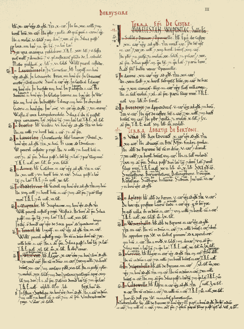
Here is the page:
The page from the book that contains Longdendale (top left)
And here is Longdendale as it was recorded in the book:
Here we are in the nearly 1000 year old book. Quite remarkable.
The above image is courtesy of this phenomenal website which has digitised the whole Domesday Book, with all sorts of notes and details. Go and explore this fascinating document, and priceless item of English history.
I’ll give you the complete transcription, translate, and then discuss what it means.
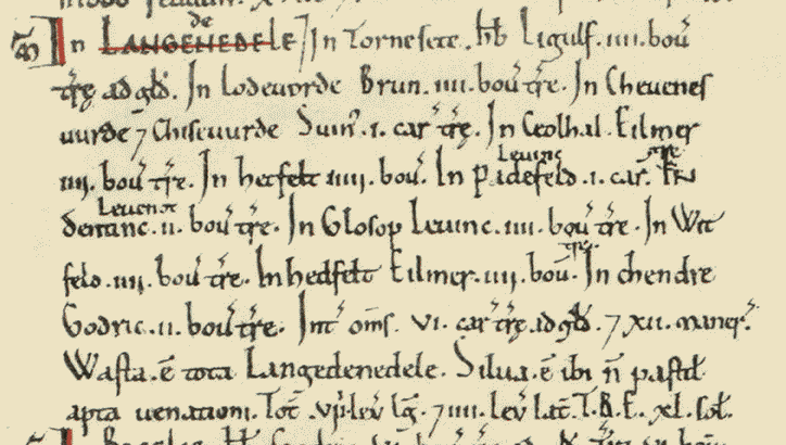
In LANGEDENEDELE. In Tornesete. Hb. Ligulf. iiii bov. Tre ad Gld. In Lodeuorde, Brun. iiii bov. tre. In Cheuenesuurde Chiseuurde. Suin. i car. tre. In Ceolhal. Eilmer iiii bov. tre. In Hetfelt iiii bov. In Padefeld. Leofing i car. In Dentine. Leofnoth. ii bov. tre. In Glosop Leuine. iii. bov. tre. In Witfeld. iiii. bov. tre. In Hedfelt Eilmer. iiii. bov. tre. In Chendre. Godric. ii. bov. tre. Int. oms. vi. car. tre ad gld. Xii maner. Wasta. e tota Langedenedele. Silua. e ibi n pastit apta uenationi. Tot viii. leg lg. iiii. lev lat. T.R.E xl. sol.
In Thornsett (Tornesete), Ligulf had 4 bovates of land that were taxable.
In Ludworth (Lodeuorde), Brown (Brun) has 4 bovates of land that is taxable.
In Charlesworth (Cheuenesuurde) and Chisworth (Chiseuurde), Swein (Suin) has 1 carucate of land that is taxable.
In Chunal (Ceolhal), Aelmer (Eilmer) has 4 bovates of land that is taxable.
In Hadfield (Hetfelt), Aelmer (Eilmer) has 4 bovates of land that is taxable.
In Padfield (Padefeld), Leofing has 1 carucate of land that is taxable.
In Dinting (Dentine), Leofnoth has 2 bovates of land taxable.
In Glossop (Glosop), Leofing has 4 bovates of land that is taxable.
In Whitfield (Witfelt), Leofing has 4 bovates of land that is taxable.
In Hayfield (Hedfelt), Aelmer (Eilmer) has 4 bovates of land that is taxable.
In Kinder (Chendre), Godric has 2 bovates of land that is taxable.
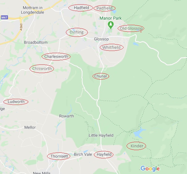
Phew! Right… so what on earth does that mean? Well, Longdendale (Langedenedele as the book has it) is first broken down into areas, then who owns these areas is recorded, followed by the amount of land that is taxable – the Domesday book is essentially a tax record of how much William stood to gain from the invasion, after all. However, here, recorded for the first time ever, are the names of the places we know well. And I am struck immediately by how similar they are… stick a decent Glossop accent onto them, and they haven’t changed at all – Whitfield and Hadfield in particular! And I love the Saxon names, too. Aelmer and Leofing are the big landowners around here with 1 1/2 and 2 carucates of land respectively, and so are probably quite wealthy and with good lands. Poor Godric is stuck out in the wilds around Kinder, where it is difficult to see where his 2 bovates of taxable land could be located. Which brings us on to the next question… what the hell is a bovate? Or, for that matter, a carucate?
They are both ancient measurements of land area. A bovate (also known as an oxgang) is technically the amount of land a single ox could plough in a single season – somewhere around 15 acres depending on land and animal. However, a plough is normally driven by a team of 8 oxen, and the amount this team could plough in a single growing season is known as a carucate. Thus, a bovate is one 8th of a carucate. Now, I struggle to picture area, so the idea of a large area defined by how much work an animal does is, quite frankly, baffling.
Following the register of places and taxes, there is a general description of the area.
Between them 6 carucates of land is taxable, and 12 manors
Each of the 12 manors (the areas named above) would have had a manor house to go with it, and one wonders where they are. I have a few ideas, but there is no way of knowing without excavation. One can imagine Leofing, beer cup in hand, sitting on a chair in the centre of his house – effectively a large open hall in which multiple people ate, drank, slept and lived around a central fire pit, the smoke from which would have dissipated amongst the thatch or turf roof, as there were no chimneys in the 11th Century.
The 12 manors of Longdendale circled in red. Thanks to Google
Looking at the above map, I am struck by two things. Firstly, how almost all of the manors are situated on major roads (Whitfield is on the old road to Glossop, before it was diverted to what is now Glossop town centre), and how they are all still recognisable and distinct places. The one glaring exception is Kinder, which ceases to be a ‘place’ as such after the Medieval period; one presumes that it is in the area of the houses and farms on Kinder Road, but further research is needed.
Then there is the single word ‘Wasta’. Waste.
“All Longdendale is waste”.
Following the invasion of 1066, the North of the country – Cheshire, Derbyshire, Lancashire, Staffordshire, and Yorkshire – rebelled against the French king. William the Bastard chose to teach them a lesson over the winter of 1069-1070, and operated a ‘scorched earth’ policy of complete destruction of all villages, property, crops and people – the ‘Harrying of the North‘ as it is now known. There is some debate about the extent of the destruction, but there is no getting away from the fact that he utterly destroyed huge swathes of the North in revenge, and North Yorkshire in particular, with refugees from there mentioned as far away as Worcestershire. The effect was such that 16 years after the Harrying, Yorkshire had only 25% of the people and oxen that it had in 1066. The almost contemporary historian Ordericus Vitalis (basing it on contemporary descriptions) describes it thus:
“Nowhere else had William shown such cruelty… In his anger he commanded that all crops and herds, chattels and food of every kind should be brought together and burned to ashes with consuming fire, so that the whole region might be stripped of all means of sustenance. In consequence so serious a scarcity was felt in England, and so terrible a famine fell upon the humble and defenceless populace, that more than 100,000 Christian folk of both sexes, young and old, perished of hunger”
The word ‘Waste’ here in Longdendale is the result of this destruction – the valley, never particularly prosperous, or indeed populous, was laid waste… the Bastard burned the place to the ground. This is an astonishing fact, and that one word – waste – resonates. Indeed, as you read through the Domesday Book entries for the surrounding areas, the phrase crops up time after time “it is waste”.
Moving swiftly on.
Longdendale is then described as “woodland, unpastured, and fit for hunting” – which is better than some of the Trip Advisor reviews for places in Glossop – and the fact that it is “8 leagues long, and 4 leagues wide” (roughly 24 miles by 12 miles).
The entry in the Domesday Book finishes with letters “T.R.E. xl. sol.”. T.R.E. stands for ‘tempore Regis Edwardi’ – that is, in the time of the reign of Edward the Confessor, and refers to the worth of the land in the time immediately prior to the invasion. In 1066, Londendale’s worth (in terms of taxes) was 40 Shillings (represented in the book by the Roman numeral ‘XL’ for 40, and the abbreviation ‘sol’ for ‘solidus’ or shilling. 40 Shillings is not a lot, comparatively, and must surely represent the poor quality of arable land in these parts, as well as a lack of mineral resources.
Now, what is interesting, is what is left out. For example, there is no mention of people – freemen, villagers, smallholders, etc. – and we are left with the impression that there is no one here. Yet just over the hill, in Hope, we read that “30 villagers and 4 smallholders have 6 ploughs. A priest and a church to which belongs one carucate of land” and that “before 1066 these 3 manors paid £30, 5 1/2 sesters of honey, and 5 wagon loads of 50 lead sheets. They now pay £10 6s.” Clearly in Hope the invasion had had an effect – they now pay £20 less in tax, so one assumes there is less there now that is taxable – but there are people there, in 3 manors. So it seems odd, then, that Longdendale, despite having 12 manors, has no mention of people. It may be poor record taking by the surveyors, or it may be more sinister – Longdendale is the main route west out of Yorkshire, after all. The other oddity is that there is no mention of the church. It is possible that Glossop Parish Church is of Anglos Saxon origin, there is no evidence for this, and the lack of a mention in the Domesday Book is also quite telling. Which begs the question… where was the nearest church? Hope? That’s quite a journey to be made every Sunday, but I can’t think of anywhere else nearby.
So there we have it, Glossop’s debut in the historical record. One wonders where exactly Glossop was at the time – certainly not Howard Town, but perhaps Old Glossop. There is the suspicion that it may have been further out, toward Shittern Clough and Lightside along Doctor’s Gate, but again, we can’t be certain without excavation.
Anyway, I hope you enjoyed this little romp around Early Medieval Longdendale, As always, any comments, questions – or even abuse from pro-Norman activists – are all very welcome.