So, I received a pair of emails recently, and both of them answered an outstanding question that has been bugging me for some time.
Answers people, we actually have answers! I asked, you listened, and by Great Zeus (or Arnomecta, perhaps) you answered.
So, drum roll please…
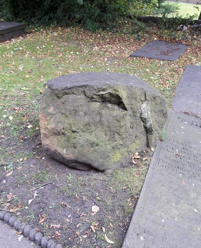
THE STONE IN ST JAMES’S CHURCHYARD, WHITFIELD.
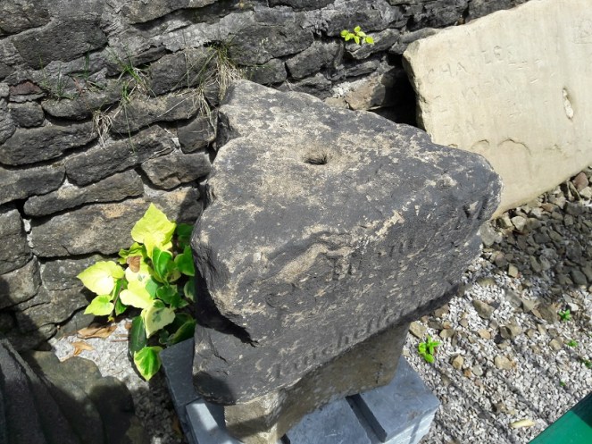
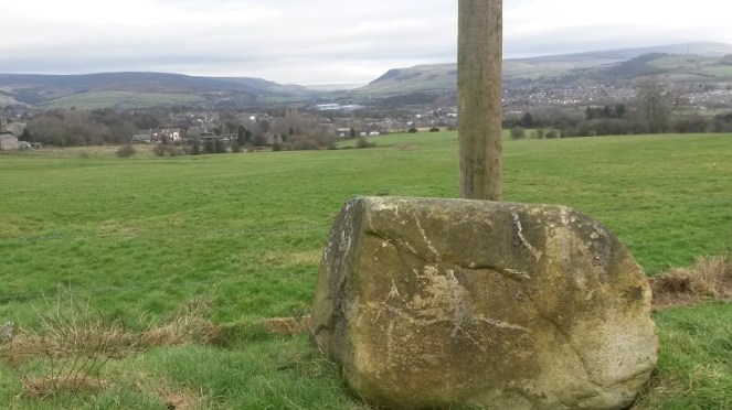
I mused here on the possibility that a large, out of place, stone in the churchyard St James’s, Whitfield, might be part of the base of the Hollin Cross that almost certainly stood at the junction there, on Hollincross Lane.
Here is the stone in St James’s – not a cross base!
I was wrong. And how!
I got an email from Louise Seville which states:
“My father-in-law Neal Seville had some connection with the church (Sunday school??), I think in the 1970s. He was giving a talk based on the parable of the wise man and the foolish man. He and his friend Bert Taylor from Chunal, brought the stone from Bert’s own small quarry at the back of his house on Chunal. The stone was moved on a truck – Bert had a haulage company. The stone was used in church to illustrate the story and was abandoned in the churchyard afterwards as it proved to be too difficult to move. Neal said that in the future people would wonder how the stone got there and come to all sorts of conclusions! “
And how right he was!
So there we have it folks. I genuinely think that it was bonkers to use a stone that size to illustrate the parable, no matter how factually correct! But apparently that was about right for Neal, who got up to all sorts of capers. Here is the parable, for those of you that slept through Sunday School.
So my thanks to Louise and Eddie Seville for solving the mystery. And, of course, thanks to the late Neal Seville for providing one in the first place.
Now, the next one has bugged me for years, so I am truly grateful for its solution.
THE ODDLY SHAPED CERAMIC OBJECTS
I asked for ideas about these bits of pottery that Sandra T. and I had found. They were so oddly shaped, and so similar in production, that they must have had a single, very specialised, purpose. But what purpose, that was the question.
The puzzling pieces of pottery
Well, bam! An email from the wonderful Eddie Picton arrived in my inbox the other day.
May I suggest that they are “creel peg pivots” as used in textile machinery. A roving bobbin had sliver wound on it, this was then put upon a creel peg and then put in following machine creel. The lower end then would be free to rotate on the ceramic with minimal friction. I worked in the last spinning mill in Oldham, the last of this type of creel was scrapped in the early 1990s, the mill finally closing 2002.
The connection between the object and the place – both connected with weaving and spinning – made this very likely, and it is not an interpretation I had thought of before. I did a bit of research, and began to understand how they would have worked. Yes, it seemed to fit.
Last night, Eddie was at the Glossop and Longdendale Archaeological Society talk on ‘Melandra – Past and Future’ given by Mike Brown and Roger Hargreaves (and very good it was too). He gave me this drawing of how the creel peg pivot would have worked and where it sat in the machine.
Great drawing Eddie, thanks.
Our pottery pieces are those marked ‘Pot’ in the picture, with the bobbin/creel peg sitting in the hollow, glazed, part of the mystery object. They are tapered slightly so that they can fit into the holes in the frame.
These are those, in situ, in Styal Mill. The photo is Eddie’s.
So that’s that solved! Thanks for that, Eddie, you’re a star. And it seems I owe you a drink… I’m as good as my word. See you on the first Tuesday of November.
I have another blog almost ready to go, so fingers crossed you’ll get a bumper crop of posts by the weekend.
As always, comments and questions are very welcome.
What ho, what ho, what ho! So, I’m back from my summer holiday. Actually, I was only in France for two weeks (with lots of cheese and wine), and the rest of the time I have been busy with life… alas. I have loved the weather here for the last 10 weeks – a decent summer at long last, and the polar opposite of the spring we had. Bizarre.
So, missing out August completely, I’m back with a bang, and hopefully more than one post over the weekend, here we go.
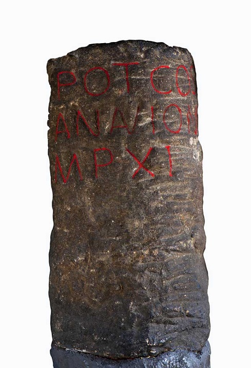
I love milestones. There is something so definite and so grounding about them, and the way in which they locate with reference to other places – you are X miles from Y – you know exactly where you are in the world. They have a long history – the Romans used them all the time, and in reality, they haven’t changed since. This one was found in Buxton, and is inscribed with the following: “TRIB POT COS II P P A NAVIONE M P XI”.
Buxton Roman Milestone, found in 1862 (and shamelessly stolen by me from the wonderful ‘Wonders of the Peak‘ website). Honestly, it is well worth taking the time to look around the site.
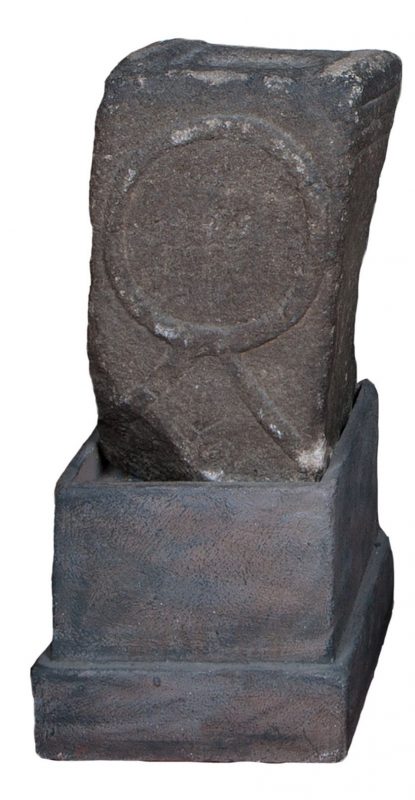
Which translates as “With tribunician power, twice consul, father of this country, from Navio, 11 miles”. The Roman fort of Navio is at Brough, near Castleton (information here). This is a great little fortlet, right on the river there, and well worth a trip out to see it. There’s not a great deal to see as such – rather like Melandra, it is lumps on the ground, requiring a bit of imagination – but it produced some fascinating archaeology. My favourite being an altar to the goddess Arnomecta – a local goddess, about whom we know nothing at all. She may be the same as the Goddess Arnemetiae who gave her name to Roman Buxton – Aquae Arnemetiae, but then again possibly not. Something about that both fascinates and frightens me – a lost Goddess.
Altar dedicated to Arnomecta – stolen again from the wonderful Wonders of the Peak website (use the link in the text above it for more information on the stone).
But I digress… where were we?
Milestones. Mine are nothing like as old, but they are interesting. Honest.
The first is located on the Woodhead Road/B6105 by Allmans Heath Farm and B&B. It is carved into the side of a mounting block, used for getting onto horses, is/was painted white, and it simply states ‘Glossop 1 mile’ with an arrow pointing the direction.
The milestone is at the bottom, carved into a niche. The ring on the block would have held your horse in place whilst you climbed aboard.Close up of the milestone: “Glossop 1 Mile”
Now, the mounting block is clearly old. They don’t make them anymore, for one, and the fact that the ring has been set in place using lead would certainly age it to the Victorian period, and potentially earlier. The carving is another matter altogether. I had assumed that the words would have been carved in the Victorian period, but on the way to take the photograph, I got speaking to the owner of the house there who informed me that they were only 10 years or so old – her ex-husband, being a stonemason, carved them. Well, why not? The fact that the mounting block sits next to a very old stone gatepost (on the right in the upper picture) suggests that the owners had moved the stone to the front wall in order to create a feature, which it does.
So, this one might not be of any great age, but the next two certainly are, even if they are slightly out of the area.
I went looking for the fabled White Stone of Roe Cross the other day.
I say fabled as there is very little information about it, and I was hoping to see it to put in my two penn’orth about what it is, why it is, and where it is. It is mentioned in Sharpe’s “Crosses of the Peak District” as potentially marking the junction of the boundaries of Matley, Hollingworth, and Mottram, so I thought it would be worth a look. Alas, I failed utterly to locate it, although I did get as near as White Stone Cottage, so I could’t be too far away. It has almost no presence online, either, besides a letter that was written to protest against the proposed Mottram bypass which mentions it in passing, and references to White Stone Cottage.
If anyone knows the location of the stone, please let me know, as I’d love to see it – and you all know how much I love a good stone.
Now, that same letter, also mentions a carved milestone in that area, and thinking it might be worth a look, young Master Hamnett and I set off down Dewsnap Lane to find it. Which we did in record time – standing alone in a right hand turn into the riding stables there (the location is shown by the red circle on the map below).
The Lonely Milestone
The stone states it is “10 Miles From Manchester” and I have no reason to doubt that. It has clearly been used as a gatepost at some stage, and you can see the hole where the hinge was mounted.
Close up of the writing and hinge hole.
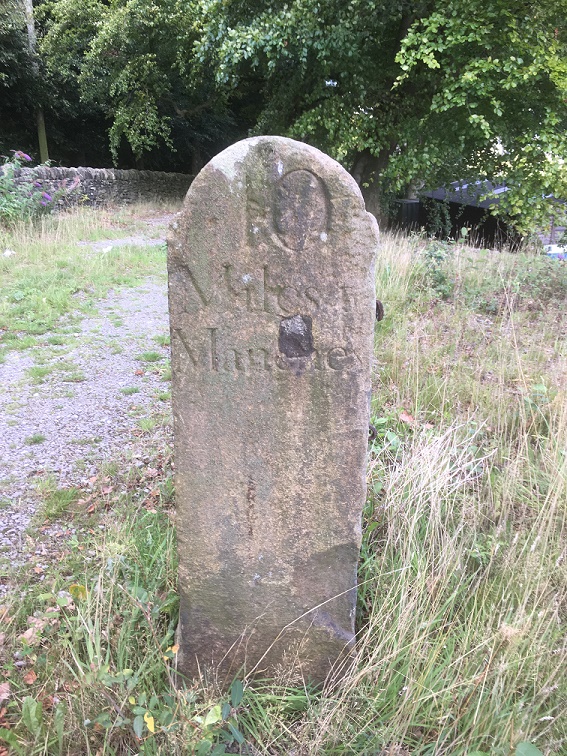
As I turned around to leave the stables area I noticed another milestone, this one placed against the wall.
Another milestone
This one proclaimed itself to be ’13 Miles From Manchester’.
“Hmmmmm”, thought I. “Ice cream” thought Master Hamnett.
Close up of the carving.
Now, I know what you are thinking… that Roe Cross is a geographical anomaly, being simultaneously both 10 and 13 miles from Manchester; a quantum place, if you will.
The two stones are obviously carved by the same hand and at the same time – the rounded top and squared shoulders are the same in both instances, and the stone is the same – a coarse sandstone. The writing is also the same, and with the ‘long S‘ in the word ‘Manchester’, we can roughly date it to not later than the first half of the 19th Century, and possibly a little before. After this time it falls out of use, and people used the ‘short S’.
So what are they doing there? I don’t know for certain, but I have a possible/probable answer.
The ‘Deep Cutting’ between Mottram and Matley/Roe Cross was opened in 1826 as part of the Manchester to Saltersford turnpike road. Essentially, it allowed easy access between Yorkshire and the east of the country, and Manchester and the west. Prior to this, the roads were in a terrible state of repair, and the heavily laden packhorses that made that journey really had to struggle. The turnpike roads were privately financed and built, and in order to recoup costs they operated as toll roads, charging for their use (think M6 Toll road for a modern comparison).
The toll gate at Roe Cross, the place you had to pay for passage, was situated here:
The Roe Cross Toll Gate is marked on the map (indicated by the arrow). The circle shows where the milestones are now situated. This from the 1875 1:2,500 OS map.
Now, obviously, the milestones are not in their original location, and I would like to suggest that they were originally situated near to, or at, the toll gate, showing the distance to Manchester along the road. However, if that was the case, then why the difference in distance? Well, perhaps the ’10 Mile’ sign was put next to the new road, whilst the ’13 Mile’ sign was by the original, old, road. With both signs showing, most people would want to shave 3 miles off their journey, and travel along a new well surfaced road, rather than along a muddy track, pitted with animal and cart ruts – after all look how many people use the M6 Toll Road. The tentative date of the stones, too, fits with the construction of the road – the first quarter of 19th Century.
Of course, once the toll gate ceased to exist, the stones lost their usefulness, and particularly once new, more clear, signs began to be used on the roads. However, instead of being broken up, their size and shape is perfect for a gatepost, and so they were hauled a few hundred yards up the hill and given a new function.
Well worth a look of you get chance, and there is lots of good walking to be had up there. I am going to have good explore myself sometime soon, particularly up Gallowsclough, which, as a placename, can have only one meaning – ‘the valley where they hanged people’. Blimey!
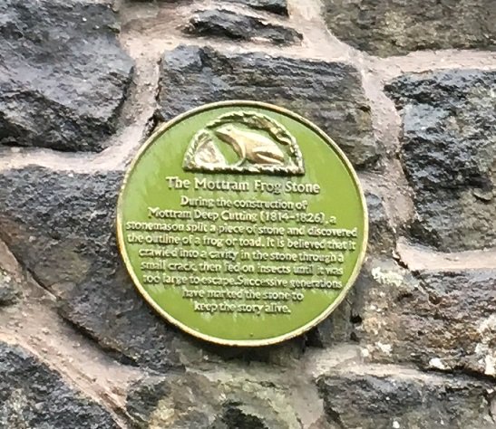
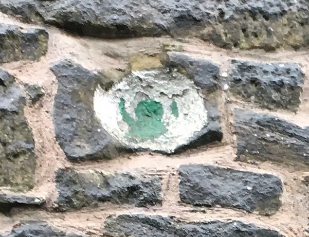
Incidentally, I love the Deep Cutting for the Mottram Frog Stone which is celebrated on the wall there, about half way down on the right (going from Mottram to Stalybridge). I couldn’t do this post and not mention it – I tweeted about it, but it is so good, that it needs to be celebrated on the blog, too.
The truth or plausibility of the story is much less important than the legend – no one criticises a fiction story for not being real, one just enjoys it!The stone itself, marked with a green frog.
There may be more this weekend, if I can manage it, but I will try to get back to my one a week post target, so stick around. Thanks for reading, and please, as always, comments and corrections are always welcome.
Evening all. The third blog post of June… see, I am trying.
Anyway, this one should (hopefully) provoke a bit of a response. I say hopefully because, dear and precious readers… I need a favour.
Some back story.
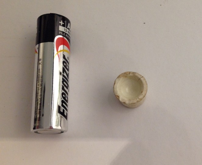
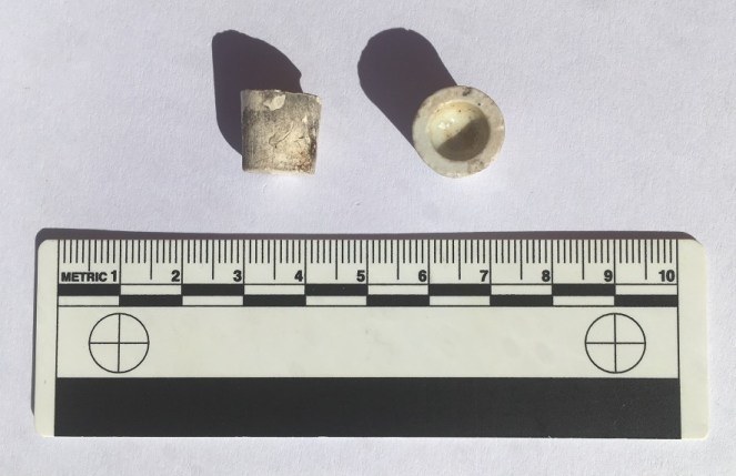
I received an email from the wonderful Sandra T. some months ago, asking whether I knew anything about this piece of pottery that she had found in Manor Park. She, like most of the people who read this blog, pick up random things they find interesting, which is to be commended (although, apparently, she keeps them in a clock… but let’s not judge).
The mystery object – AA battery for scale. Copyright Sandra T.
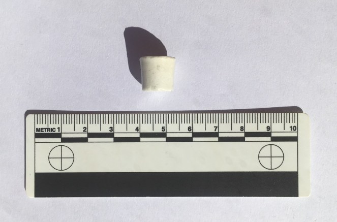
Now, I had no idea what it was, but it rang a bell. a brief search through my ‘interesting things’ box, and lo!
Two more of these mystery objects.
So now we have three of these mystery objects. I found mine in an old dump near Broadbottom, which at the latest was 1910’s, but was generally earlier – say 1890’s – which at least gives us a time period to look at.
Interesting. I thought I’d do this post eventually, as someone out there might know what , when, and why.
Last month my new neighbour (hello Simon A.) partly demolished and rebuilt a wall on our property line, and in the process discovered that the whole wall sits on a bed of pottery and other domestic waste. This mountain of material will be the subject of a future post, especially as it makes a fairly coherent deposit, thus can tell us interesting things. The wall can only have been built post 1850-ish, and definitely before 1860, which gives us a clear date, too. Amongst the bits and pieces was this:
Another one… what are they?
So now we have four of them.
They are roughly conical, tapering to the base, measure between 10 and 12mm high, 13-14mm across the top, and roughly 11mm across the bottom. The bottom is flat, the top is hollow in a perfect hemisphere (I say top and bottom, but actually they might work either way up). Some are glazed all over, but one is only glazed on the interior of the hollow. This last point is important, and may hold the key to understanding what they are; it matters that only this bit is glazed, i.e. waterproof, not the rest of the object. Why? Also, they are clearly mass produced, and have a very specific role… but what?
I have two suggestions, both of which may work, but equally they are guesswork!
1) Kiln furniture. When you fire pots in a mass group, as they were being in the Victorian period, you need to keep the plates, etc. separate in the kiln, or the heat won’t circulate properly and you end up with poorly fired plates. These spacers were made in their millions, and were about the same size and shape. Though what they would be doing here in Glossop – not known for it pottery kilns – is anyone’s guess.
2) A way of selling medicine. The little hollow bit is glazed, but the exterior isn’t, so perhaps the medicine was stored in that bit, and scraped out when needed? Or it held a single pill that could be crushed in the hollow?
So over to you. Please, please comment and let me know what you think. The question is very simple. What on earth are they?
I’ll buy a drink for anyone who can tell me, with proof, what they are.
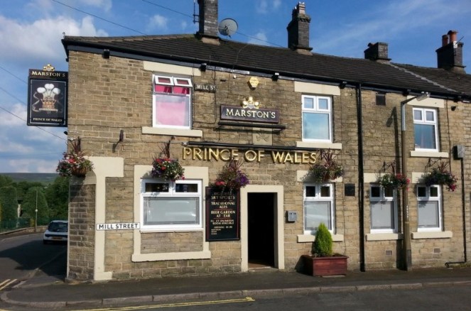
I went for a pint with my father in law a few weeks ago (hello Mr B!) in what has become a bit of a Wednesday evening post-work ritual for us. We popped to the Prince of Wales in Milltown which, I am reliably informed, was built in 1852. And an excellent pub it is too – good beer, and a great beer garden. It has a real sense of history about it, especially as the area is now being developed so heavily, and I would imagine that it would have been a bustling pub, rowdy and rough, in the 1800’s.
I love the corner door, now bricked up – probably the entrance to the tap room – and the carved ‘Fleur de Lis’ (traditionally the symbol of the Prince of Wales) above the door is a nice feature. Also, note the Victorian street sign for Mill Street to the left of the Marston’s sign. Fascinating.
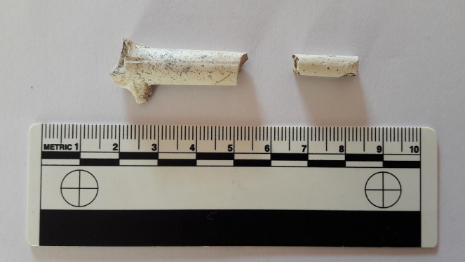
Sitting drinking my beer and chatting, I had a look around to see if I could see anything of interest, and lo! In the flower bed amongst some more modern glass and pottery, were these beauties:
Clay pipes – the cigarette butt of the Victorian Period.
I love clay pipes, I really do. There is something so tactile about them, and so personal too. I joke about them being the cigarette butt of the Victorian period, and they are in a sense – smoke them and then throw them away – but they embody so much more. Believe it or not, they are the subject of many very detailed archaeological studies; they are mass produced, but they show features that shift over time, allowing a fairly precise date to be given to the pipe, and possibly then to the site/building/feature. Google “clay pipe chronologies” for examples. I’m not going to go into too much detail, as I really am no expert, but these two examples are very obviously Victorian. The bit on the right is part of the stem, and comes from near the mouth-piece, as the stem get thicker nearer the bowl. The piece on the left has the stem, spur (that little bit the points downwards), and the lower part of the bowl, where the tobacco itself sits, and which in this case shows signs of burning. Neither are particularly interesting, and they are certainly not rare, but nevertheless are integral to the human story of Glossop, and one wonders what conversations were happening in the pub whilst they were being smoked?
The history of The Prince of Wales, and all other pubs of Glossop, past and present, are detailed in the excellent book ‘History in a Pint Pot’ by David Field. Meticulously researched and fascinating, it is highly recommended to anyone with an interest in the history of Glossop, pubs, or beer – so that’s all boxes ticked for me. It is now out of print, sadly, but Glossop library has a copy. You could also check out the superb Glossop Victorian Architectural Heritage website, they have lots of information about pubs, and much more besides. Well worth a look.
Moing on, this next pipe is a bit more interesting.
I found it a while back on the edge of my favourite path – Bank Street, or the ‘Bonk‘ as it’s known locally. However, not being born in Glossop, I would feel a fraud calling it the ‘Bonk‘, so Bank Street it is.
I love dialect words and phrases – the way that the beauty of the English language is tied firmly and absolutely to the place it is spoken is truly remarkable. American friends of mine marvel at how many accents there are in such a small island. And yet if we go back 100 or so years to a period before mass media, it would have been possible to tell not only which town you came from, but which part of the town, and indeed which street you lived on. Now that we are bombarded with accents and the media is dominated with southern ‘Estuarine‘ English, we are slowly becoming linguistically homogeneous and eventually we may lose our accents altogether, which I think would be a shame. What is interesting about ‘Bonk‘ as a word is that it not only partly reflects the Glossop accent, but it is also almost certainly derived from the medieval French ‘Banque‘ meaning a steep wooded valley next to a stream. It crops up in Cheshire dialect as ‘Bongs’, and the nearest examples I can think of is Leebangs Rocks in Broadbottom (Leebangs = Le Banques), and The Bongs both in Handforth, and in Goostrey. It’s not often you encounter Norman French in Glossop!
But I digress! It was found not too far from the bottle top I blogged about here. I thought it nothing particularly special until I got home and cleaned it. Wow!
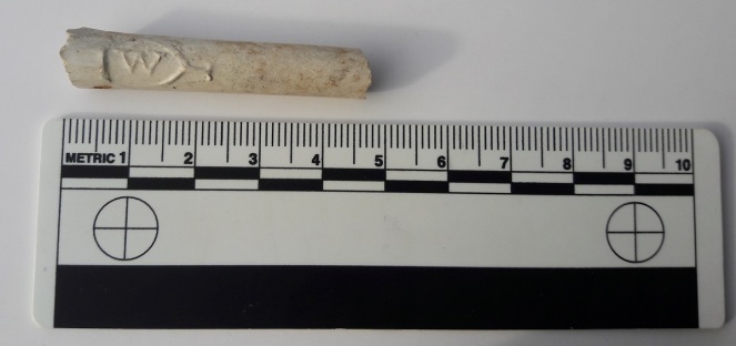
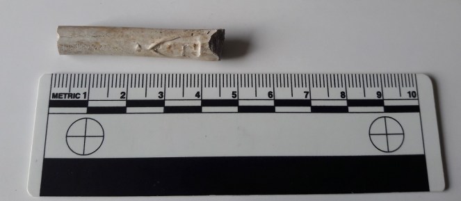
Side 1 – ‘W’ CartoucheSide 2 – ‘T’ Cartouche
It’s the front part of a clay pipe, just at the point where the stem meets the bowl – you can see it thickening into the bowl. But on either side, imprinted into it, is a cartouche containing the letter ‘T’ and letter ‘W’. Presumably these are maker’s marks, but unfortunately, I cannot find any information out about who or what ‘W’ and ‘T’ were. Also there is the suspicion that they may actually not be maker’s marks as such, but were instead used by many different companies as a way of suggesting quality – it was perceived by the buying public that those letters were associated with a superior pipe (I read this somewhere, and now can’t find the reference… grrrrrrr). This would be similar to the Victorian belief that pipes from Ireland were the best, and thus many clay pipes have the words ‘Dublin’ or ‘Ireland’, or have a harp or shamrock imprinted on them somewhere… despite being made in Birmingham or similar. It is Victorian in date, and scrubbed up quite nicely!
I was originally going to blog about this in a larger post about the trip down Bank Street (which I will still write… honest!), but it seemed to fit in here better.
By the way, if the landlord of the Prince of Wales reads this and wants the pipes back, I’ll bring them round next Wednesday!
EDITI found the reference to ‘TW’ – it was in the Clay Tobacco Pipes report by Dennis Gallagher, and from the High Morlaggan Project (the report is under excavation / reports / clay pipes). In it, it states that ‘TW’ pipes “were an extremely popular type and were produced by most makers. The meaning of the letters is unknown, although it may originally been used by the early 19th century Edinburgh maker, Thomas White, who was renowned for his high quality pipes“.
So, once again, I am forced to apologise for the lack of activity here of late – I expressly didn’t want the blog to be like the diary you start on New Year’s Day, full of good intentions, only for the next entry to be Auntie Mabel’s birthday sometime in July. The same can be said for those of you who I have not yet replied to their emails. So by way of an apology to you all, have a series of posts, starting with this one on the Guide Stoop.
Following on from the revelation here that one of the destinations on the stoop is probably Hayfield, I came across another example of a triangular guide stoop – this one is in the care of Saddleworth Museum and is kept in their outside/garden area.
The triangular guide stoop at Saddleworth Museum, similar in shape and style to our own.
It originally stood where the Standedge Road meets the A62 Huddersfield Road, and shows 6 destinations, two on each face, including Oldham, Manchester, and Huddersfield. Here’s how it would have originally looked:
From Huddersfield Highways Down The Ages by W.B. Crump
So this is similar to how the Glossop guide stoop would have looked… which got me thinking! If its original location was the top of Whitfield Cross, I wonder if the stoop would once have stood on top of the cross shaft. I find it unlikely that the guide stoop makers and installers would have made a new shaft if there was one standing in the right place already. Especially, as we must remember, by this time (early 18th Century) it had already lost its cross head, and due to puritan and Methodist views of the local people, would have lost all of its symbolism as a ‘Christian’ thing. In fact, so much so had it fallen from grace, that less than 100 years later it would be nicked and moved as a prank. So why not bung it on top of this convenient shaft?
Now, there is no evidence for this, and certainly there is no indication that anything was fixed to the remaining portion of the shaft as it is now, but we don’t know what was removed, or has worn away in its intervening 200 years standing as a stile. Just a thought.
A glorious weekend – I got all my vegetables planted, the garden was tidied, the lawn was mown… and wine was drunk in the sunset. A very succesful weekend indeed.
I was going to blog about some bits and pieces I had found recently, but two wonderful things happened over the last few days. The first of which will have to wait… it will take a bit of unpicking (and cleaning and researching). It is very exciting. And lots of it.
But for now, I present the second wonderful thing, a gift from my raised bed of onions and garlic!
You can see the marks where it has been shaped, though I don’t know how they were made.
Ok, so I know it doesn’t look like much (so many of my blog posts start like that), but it’s the bottom end of a Victorian (or very early Edwardian) child’s slate pencil. Paper was a very expensive commodity in the Victorian period, and you certainly wouldn’t have given it to children to learn to write on. Instead, they practised their copperplate handwriting on slate writing tablets with slate pencils such as this.
Years ago, I found an old wooden pencil case in a junk store, and in it were two complete and several broken slate pencils – it’s nice to see a complete original one.
A complete version of a slate pencil – again, you can see the grinding marks where it was shaped.
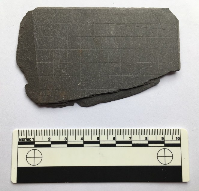
Last year, I was poking around a Victorian rubbish tip with a friend (as you do…), and I came across this broken example of a writing slate.
Broken writing slate. You can see the lines used to guide the child learning copperplate script.
The thing is wonderful. You can clearly see the engraved lines – thin, thick, thin, for the upper, middle, and lower part of each letter – to keep the child’s letter forms perfect and copperplate. But look at the edges too – they are shaped – it may be mass produced, but some care has gone into how it looks.
I turned it over, and found this on the reverse
More engraved lines.
Wonderful – squared paper for maths problems, and probably for art too. I love this object, and it is among my favourite things that I have found. Sadly, it wasn’t in the Glossop area, but in deepest, darkest, Lancashire, but I thought I’d share it anyway to illustrate my pencil… so to speak.
Here’s what it would have looked like when it was being used.
Victorian writing slate, lifted from this website.
The question is, then, how did the slate pencil fragment end up in my garden?
We archaeologists are obsessed with object biographies:
“Not only do objects change through their existence, but they often have the capability of accumulating histories, so that the present significance of an object derives from the persons and events to which it is connected.”
(Gosden C. and Y. Marshall. 1999. ‘The Cultural Biography of Objects’ p.170)
And this object has a fascinating biography. It starts with a pencil being dropped by a child and broken. It is then thrown away into the toilet with all the other rubbish, and taken away by the night soil man. Via the process of night soiling, it ended up spread onto a field. But not my field, yet. This is the interesting bit – the raised bed in which I found it was filled with soil that we bought from Lymefield Garden Centre in Broadbottom (highly recommended, by the way). The source for this soil is, I think, just behind the garden centre, but the original location for the pencil (i.e. the school) was probably Manchester, or perhaps Ashton Under Lyne (although, I suppose there is no reason to assume that it couldn’t have come from a school in Broadbottom).
The fact that the pencil may have started out being used in Manchester, and ended up in my onion patch in Glossop, via in a field in Broadbottom, is a cautionary tale for archaeological intepretation – we could have simply assumed that my house was once used as a school.
Anyway, slate pencils are not uncommon finds in fields and gardens – night soiling means they get around, and they stick around as, like pottery, they are virtually indestructible – Here, for example, is one on a blog run by a gardener who records the things she finds in the soil. And a brief glance around the internet produces a number of similar results. Still, it’s a nice little find, and a wonderful piece of social history.
With nothing open, the roads all but impassable, and with the wind roaring outside, it gives me the perfect excuse to open a bottle of wine, light the fire, and blog some more.
A few weeks ago I went for a walk up the hill and along the path that runs past Whitfield Cross. In the field before the cross, there was what can only be described as an infestation of moles. A big infestation… it looked like it had been bombed!
In the past I have found some very interesting things in molehills – a mesolithic flint flake, a WWI German 7.92mm bullet (in Belgium), and a sherd of 2nd century Roman pottery. I also know of a molehill that produced an Iron Age stater coin (sadly, not mine). So, I never pass a molehill without having a look.
I have to say, this haul was sadly not as impressive as that, but I’m using it to illustrate an interesting historical process, as well as an archaeological phenomenon. But first the haul.
Gifts from the moles!
Top left is a rim from a cup or similar open small vessel. Top middle is a from a glass vessel – it is a rim of some form, but is shaped in an odd way, so I think that it comes from the spout of a glass jug. Top right is a brick… plain and simple. Bottom left is a Bakelite comb fragment – the maker’s name is ‘Tudor Rose’, who, as far as I can tell, still make combs. And finally, bottom right is some cinder – essentially what is left after coal has been burned.
So not at all impressive, or even that interesting. The interesting bit lies in the question “how did it get there?”.
Any ploughed field you see, anywhere in Britain, will have a huge amount of pottery and glass lying within the ploughsoil. You can even see it at a distance, glistening in the sunlight. And most fields will have been ploughed at some stage in their history, even if they are pasture land now. So how do these items end up in the ground? There are no brick structures nearby, nor are there any coal fires. It’s an odd place for someone to comb their hair, and even odder for them to serve drinks from a glass jug into a china teacup. If these were found next to a house, the solution would be simple – they are rubbish chucked over the back fence. But this is a middle of a field in the middle of nowhere, and nobody walks into a field to dispose of rubbish.
The solution is night soil. A lovely Victorian euphemism for… well, let’s not beat around the bush. Poo.
In the Victorian and early Edwardian period, and even more recently in certain areas, no one had an inside flushing toilet. One did one’s business into a bucket that was emptied every night by the night soil man, whose job cannot have been a bundle of laughs. Also, as there was no real system for the disposal of domestic waste, if you dropped a plate, you simply chucked it into the bucket, along with glass, coal fire ashes, and anything else that couldn’t be mended or recycled. The night soil man would then come along, remove the bucket and contents, and take it away.
The larger fragments of pottery, etc. would be removed, but no one wants to spend too long picking tiny pieces of pottery out of the waste. What was left over, including the smaller pieces of pottery, etc., would be sold to farmers as fertiliser, and who then spread it onto their fields. A wonderful system of literally wasting nothing, and one that some environmentalists are promoting – better than using artificial fertilisers, apparently. Over time, a huge amount of pottery and other bits would have been ploughed into the soil, which is why so much of it is still visible.
So there you go, the story of how these random bits ended up in a field – the mole simply turned over a night soil fertilised field. I am assuming they originated in Glossop – the town was very densely populated, and there was very little by way of sanitation in the Victorian period. Most houses, being terraced, would have had a shared privy – we have our row’s privy in our garden and it is now used as a shed! But it once served 6 houses, with at least 5 people in each house by the late Victorian period – that’s a lot of night soil!
There is a place in Upholland, Lancashire, next to the canal, where barges full of night soil from Liverpool would be unloaded and spread onto a huge cobbled area there and roughly sorted. It is right next to a pub whose name escapes me, pleasant and rural now, but 130 years ago would have been very different!
Anyway, the moral of the story is always check out molehills (and also any ploughed field), as you never know what might turn up. And don’t worry, 100+ years is a long time for night soil to linger… just don’t think about it, and wash your hands afterwards, just in case!
I thought I’d venture a little farther afield this week. The blog is intended to explore Glossop’s heritage, but I feel that if I can see it from Glossop, I should be allowed to blog about it… even if it is in another county.
But don’t worry, we won’t be going to Yorkshire!
St Michael and All Angels church in Mottram dominates this end of Longdendale – it is visible from all sorts of angles, disappearing as you travel various roads and paths, only to pop up unexpectedly from behind buildings or between trees. Indeed, it’s presence keeps watch over the valley, almost as a reminder that the church watches over the people. In fact, I can see it from James’ window, on the distant brow.
St Michael and All Angels, Mottram. Photograph by Stephen Burton.
It sits on a prominence called War Hill (from the Middle English Quarrelle, meaning quarry), and is a particularly bleak place, catching all the wind that roars down Longdendale from the moors. The church itself, though severely ‘improved’ during the Victorian period (read, monkeyed around with and partly rebuilt) is still at its heart essentially late medieval in date – mid 15th Century or so. Going further back, it may well have been the site of Saxon church prior to that. Travelling even further, there is evidence in the form of cropmarks that it might have been the site of a Roman signal station connected to Melandra – a perfect place with commanding views up and down Longdendale. Prior even to that, particularly given its prominent location in the landscape, it must surely have been attractive in prehistory, though there is no evidence at present.
As an interesting aside, during the late 17th Century a whole pile of my ancestors, the Williamsons, were ‘hatched, matched, and dispatched’ here (that is, they were baptised, married and buried). The Williamson family married into the Sidebottom family who were fairly big in this area, were important in the early Industrial period, and were consequently quite wealthy. Alas, my line gradually becomes poorer, and we end up in East Manchester working in a mill, rather than owning it.
Signature of John Williamson, my great, great. great, great, great, great, great grandfather, born in 1678 in Mottram, and who married Elizabeth Sidebottom on 15th February 1703 in Mottram Church… exactly 315 years to the day, today, coincidentally, and rather spookily. I will raise a glass to them whilst looking at the church as soon as I have published this post!
Perusing the old OS maps of the area, as I am wont to do (here), I noticed three wells in the immediate vicinity. Now, nothing unusual there, the whole area is teeming with them as we live in an area with a high number of springs. However, what was unusual is that all three, very close together, were named. Normally, a well is simply marked ‘well‘ on an OS map, but the fact that these have names could indicate that there may be more to them. And what names they are – Daniel Well, Grave Well, and Boulder Well – names that conjured up wonderful images. Well, well, well, I thought, this must be worth an investigation.
The three wells, Daniel, Grave, and Boulder, are outlined in Red. Mottram church is outlined in green in order to get your bearings. This is from the 1886 1:2500 OS map. Note also the Coal Shaft and Mottram Colliery marked – the area has a very low quality coal seam running through it that was sporadically mined in the 18th and 19th centuries.
And so it was.
Daniel Well is situated on the left, northern, side of a track that comes from War Hill along the side of the school, and downhill to a pond. Interestingly, the only artefactual evidence from this exploration came from this first part of the track, just behind the school playground.
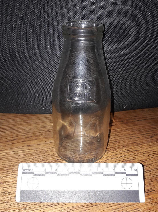
1/3 pint of Co-Op school milk in a squat bottle. This really is a nostalgic trip!
I am just about old enough to remember free school milk, and these are the bottles they came in… It has been over 30 years since I touched one of these last, and the feeling was one of immediate nostalgia and a weird sense of happiness. Silver foil top and a blue plastic straw… I was back in Bradshaw Hall Infants School, just like it was yesterday! What I love about this artefact is that the only way it could have ended up on the track behind the playground is if some naughty child threw it over the fence… if you put it to your ear, I swear I can hear the “vip, vip, vip” sound of Parka coats rubbing together and the cries of “go on, I dare you… chuck it!”.
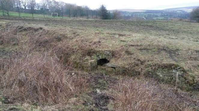
On to Daniel Well, then. The sunken path is muddy, but well constructed and was clearly used – I wondered if this was the main well for the area. My first sight of it seems to confirm that thought.
Daniel Well, overgrown and unloved. Beyond is the playing field of Mottram School, and beyond that, Longdendale.
The path widens out at this point, and the stone built well head structure stands well built still. The path is very boggy, and although the well is overgrown and possibly relatively dry in terms of water within it, the spring that created the well is still flowing freely downhill.
Close up of Daniel Well. Stone built arch, and side platforms upon which to put your buckets, bottles, etc.
The stone-built arch that is the front of the well goes back some three feet, although it is sadly now full of collapsed rubble. To me, this seems a sad end to what was one of the most vital aspects of the village – lives were, quite literally, saved with this water. Food, drink, laundry, baths, all came from this point. People who met drawing water here married in the church above, and had children. Gossip and community, focused on this place, and yet, no longer. I would love to see it restored, or just a little better cared for.
Following the path down, the water flows into this secluded and sheltered pond.
The pond from the end of the track. The water flowing into it from behind the camera comes from Daniel Well. It then flow out again through a channel to the left.
Clearly Daniel Well was an important well in the area – the path and the stone built well head attest to this. I have no idea about the name, though – possibly from a personal name of the person who owned the land? Something Biblical, maybe? Any thoughts, anyone? The 1954 1:10,00 sees the last mention of Daniel Well on an OS map, and clearly by that point it had ceased to be important as a water source. Sadly, I doubt anyone living nearby would know it was there now, or at least know that it had a name.
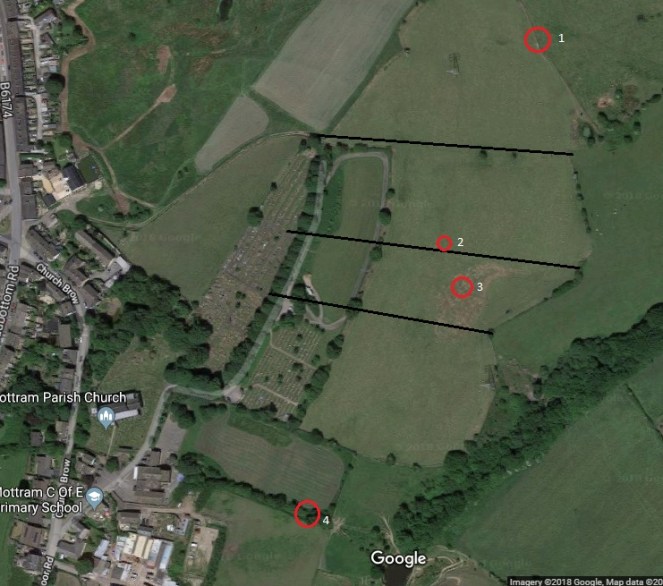
Making my way back up, I decided to look for the other two wells. I had studied Google maps before exploring, and took a while to work out the locations by superimposing the old map field boundaries onto the modern satellite image of the area.
4 is Daniel Well, 3 is Grave Well, and 2 is Boulder Well. 1 becomes important in the discussion below. The black lines are the field boundaries shown in the 1886 map that are no longer there to help with orientation.
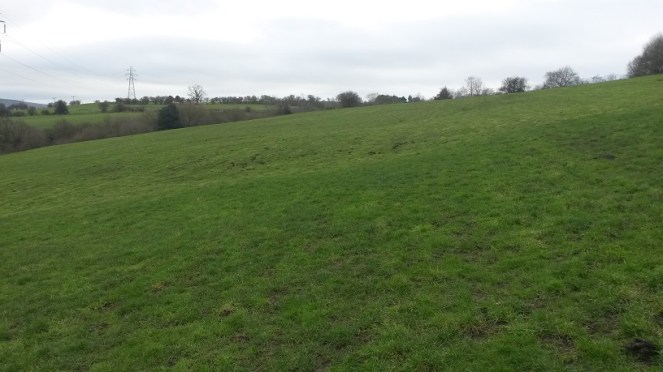
Alas, there is nothing left of Grave Well except a muddy patch in the field.
The muddy area in the middle ground, in the slight dip, corresponds to the location of Grave Well. The ground was boggy and is clearly a spring of some sort. The view is looking south.
I am not sure what would have stood here originally – perhaps a structure like that at Daniel Well, but I feel this is unlikely: it is in the middle of the field, and with only a minor footpath to get to the well. No, I think it more likely that it was a simple affair that held some water where it bubbled from the spring underneath. I love the name, though – obviously derived from its proximity to the burial ground of the church, out of view to the right in the photograph. Either that, or it may recall the discovery of a burial in the immediate area. Either way, it does raise interesting questions about water tables and burials, though, and I’m not sure I would like to drink from Grave Well! Its last mention before it disappears into the veil of history is on the 1882 1:10,000 OS map. It clearly lost its importance, and was gradually forgotten about.
Pushing further on I looked for the Boulder Well and, when I found it, was similarly a little disappointed… at least at first, anyway. It was another muddy patch.
The muddy patch in the left foreground corresponds to the location of Boulder Well on the map. The view from here, looking east, is incredible – Longdendale Valley at the left, Glossopdale at the right, and the hump of Mouselow just right of centre. Melandra is somewhere dead centre of the photograph. Despite it being dark, I am quite proud of this photograph.
As with Grave Well, I am not sure what would have stood here originally – probably nothing much. Also, in common with Grave Well, the last mention of it on the OS map is the 1882 1:10,000 map, after which it disappears, and is gone forever. The name intrigued me, though: Boulder Well is a very specific name, deriving from… well, one assumes… a boulder. The lack of boulder is, then, confusing, and a little disappointing.
I pushed on regardless, to see what I could see. And lo! In the next field north, at the edge, there stood a bloody big boulder!
The boulder! Looking north. It is marked as point ‘1’ on the satellite map above.Close up of the boulder. It is a glacial erratic of some sort, rounded and left behind by the retreating ice.
Now, although it is in a different field, this must be the origin of the name Boulder Well. Indeed, it appears to have been moved ‘recently’ – it is sitting on top of the grass, rather than embedded in it. However, if it had been moved, this at least would explain why it is in a different field from the ‘well’, and why it now stands comfortably out of the way at the field boundary. I wonder when it was moved, and where it stood originally.
The boulder, with the Longdendale Valley behind it.
The fate of these wells is interesting, and is obviously tied to the introduction of clean piped drinking water directly into your home. We – and I am very guilty of this – have a tendency to romanticise the past, and a wish to remove the trappings of modern day living, to peel back all the ‘progress’ we have made, and to revert to a simpler way of life. I love the idea of having to walk to a well to draw pure cold water, it would be so… earthy, grounding, basic. Free and simple.
But then I have never done it in the rain, sleet, or snow, wearing ill fitting wooden clogs, wrapped in a basic cloth shirt, slipping down a muddy unmetalled path, after having worked 15 hours in a mill.
I may yearn for a less commercial, more simple life… but I don’t yearn for pneumonia.
Hope you enjoyed the jaunt around Mottram. I have a few more posts I’d like to do about various wells – they intrigue me – so watch this space.
There is still lots to do, and lots more to find – but I saw this the other day, up on Cliffe Road, on the exterior wall of a garden.
T & J captured forever! I like to imagine a married couple (Tommy and Jane?) still together but now in their nineties, and who still feel a pang of guilt every time they walk past this wall.
Who ‘T & J’ were, we may never know, but the stone has been re-used from elsewhere to build the wall – which means someone saw the graffiti and thought to keep it right side up and readable, which I think is nice.
Now, more seriously. I mentioned the book, Medieval Church Graffiti, in the last graffiti post (here). It is a really interesting read, and has resonance in the work I do at the Blackden Trust (link here), so I can’t recommend it highly enough. However, the rather incredible folk at Tameside Archaeological Society (website here) have begun their own project at Mottram St Michael and All Angels, looking at the graffiti there… and coming up spades (pun fully intended). Their brief report is here, but let’s hope for more soon. Actually, in a way, I’m annoyed, as as soon as I read the book, I thought “I know, Mottram church, that’ll have some graffiti, and I’ll be able to post it on the blog…”. But I have been beaten to the punch.
However… If anyone fancies spending an afternoon or two in Glossop’s All Saints Church looking for graffiti, give me an email. Although the building as it stands dates largely from 1831 onwards, it replaced the medieval church, and reused some stone in the rebuilding process, particularly in the nave. There may be something left behind… perhaps. Anyway, drop me a line – but at least glance at the book first (here).
The next post (Thursday… probably) will be based around Mottram church, so keep your eyes open. Oh, and more pottery is incoming.
Well, so far I have managed to fail utterly in my New Year’s resolution in posting at least once a week. So my apologies. A lot of my spare time has recently been taken up with writing and preparing for a talk I am going to give on the subject of Whitfield Cross. Interestingly, the Whitfield Cross post (here) is by far and away the most popular on this blog. I know this because behind the scenes here, there are a whole pile of statistics that can be accessed that tells me how many people visit each day, what they look at, and even from where they come – yesterday, for example, I even had a visitor from South Africa! Now, I have no idea why the Whitfield Cross post is so popular, but when I was asked to give a talk on any subject, I though I’d go with that!
The talk is titled: Whitfield Cross – Glossop’s Saxon Heritage
To be given to the excellent folk of the Glossop and Longdendale Archaeological Society (website here) on Tuesday 3rd April at the Bluebell Wood pub, Glossop Road, Gamesley. Talk starts at 7.30, so get there a little earlier, and it’ll cost £2 on the door (although for £5, you can join GLAS and reap the benefits for the year).
The talk will draw on the blog post, but will include new research into Glossop’s only Anglo Saxon feature, and include a discussion of other examples of Mercian Round Shafts.
Plus, this is your chance to find out who Robert Hamnett actually is… and buy him (well, me) a drink!
In all seriousness though, come along – if you are interested in the blog, or Whitfield Cross, you’ll be interested in this.
Right, despite having another cold (courtesy of the ever ill James), I shall try and bash out another blog entry