Archaeology · History · Whitfield

Datestones

(And apologies to those of you who have ended up on this website expecting to find an informative article on the seed of the Phoenix dactylifera.)

What ho, magnificent readers! I trust you are all rude health as we stumble toward the season of goodwill and whatnot. I love this time of year, when the cold wind blows, and the… What’s that? What do you mean “get on with it!”. Honestly, the nerve of some people.

Righty ho. Datestones. Who doesn’t love a good datestone? I mean, what’s not to love? A little snapshot of the history of a building, a birth certificate if you will, recording both the date of birth, and, if we’re lucky, the parents too.

Normally, though not exclusively, located above the door, these carved stones preserve the date of construction and the initials of the person or family who paid for its construction. The are by and large the reserve of the aspirational ‘middle classes’ of society; the poor man doesn’t build his house, the rich man has a house that speaks for itself. Indeed, it is a statement to others: I have wealth enough to build this house. They seem to become popular in the 17th century, as the ‘yeoman farmer’ becomes a class of person, that is, a person who owns the land they farm. Indeed, it may be a result of that phenomena, a way of setting themselves apart from the simple tenant farmer, who doesn’t own the land he works. Glossop has several 17th century examples remaining, though many more will have been lost, sadly. They do show up, occasionally, as the one found by Glossop Brook at Harehills Park did, and which was saved and cemented into the brook wall. Interestingly, this example also shows that whilst datestones can be a boon to historians, they can also present problems if we are not careful. They can move easily, and be attached to other buildings giving a misleading date, as is the case there, and at Hall Fold Farm. Also, stones can be put in place to commemorate a rebuilding or alteration to an existing building, causing similar, if opposite, problems.

By the Victorian period it was common to put a date and/or name on a house you built, and a careful look at many rows of Victorian terraces around Glossop will reveal names and dates. With that in mind, I have restricted my research to those datestones that carry a date prior to Victoria’s reign, pre-1837. The following is a table of the ones I know about:

There are 28 datestones in the Glossop area (broadly defined), but there will be more lurking that I don’t know about, either attached to the building still, or lying in a garden. This blog post will concentrate on the examples from Whitfield, as it is turning into a much larger post than I had thought. Plus, in the interests of honesty and transparency… I haven’t got photographs of all of them yet!

Whitfield has some of the oldest buildings in the Glossop area, and although not really much of a ‘place’ now – essentially just a ‘suburb’ of Glossop – it was once hugely important, being built along the Chapel en le Frith to Glossop road. It gradually lost it’s importance with the rise of the mills based down in the valley, the economy here being agricultural. Whitfield’s one-time importance means that we find many old buildings and a number of datestones here. Indeed, Whitfield has more old buildings that Old Glossop, which with its Church and market, was the focus of the farmsteads and settlements of Glossodale. However, important places tend to be subject to more intense rebuilding over time, whereas more minor areas maintain their old buildings. I was going to do a distribution map of the old buildings, but changed my mind for that reason. Still, it’s worth noting that Whitfield underwent a bit of a building boom in the mid to late 18th century.

35 Whitfield Cross.

35 Whitfield Cross was built in 1773 as a farmhouse, and is a Grade II listed building – see here for more details. The narrow coursed stonework and stone mullioned windows are typical of the period.

61 Hague Street.

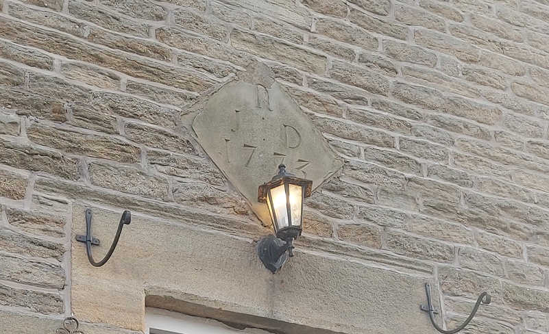
61 Hague Street was also built in 1773, but as a pair of weaver’s cottages, and is also a Grade II listed building. 1773 must have been busy year, and Whitfield was clearly a happening place in the late 18th century. The datestone records the initials R. J. and D. Now, presumably the ‘R’ is the surname (possibly Robinson – the family being quite prominent in Whitfield) with ‘J’ and ‘D’ being the husband and wife who are responsible for the building. I have no information regarding the people, sadly, and any information would be appreciated.

Hob Hill Cottage

Hob Hill Cottage is a remarkable building dating to 1638, making it the second oldest building with a datestone in the Glossop area (after the Bulls Head in Old Glossop, dated 1607). Also built as a farmhouse, and also a Grade II listed building (there’s a theme developing here!), I suspect it might be the source of the lead came and glass, as well as some of the 18th century pottery, I found nearby, although truthfully any one of a number of buildings – existing or long gone – might be the source.

Old School House, Hague Street.

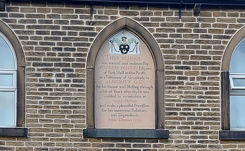
Another Grade II listed building now – the Old School House. Joseph Hague was something of an important man – indeed, the road on which the school (now private residences) sits is named after him. Born in Chunal in 1695, he rose from poverty to amass a fortune selling yarn to weavers and buying back the cloth they produced, to sell on. However, here is not the place for a discussion of his life, or of the school (the Glossop Heritage Trust does that very well here). Let us instead look at the wonderful inscription

“This school was erected and endowed by JOSEPH HAGUE Esquire,
of Park Hall in this Parish as a testimony of Gratitude to
ALMIGHTY GOD for his favour and Blessings through a life of
years whereby he was enabled to accumulate an ample fortune
and make a plentiful Provision for his numerous Relations and
Dependents. Anno Domini 1779.”

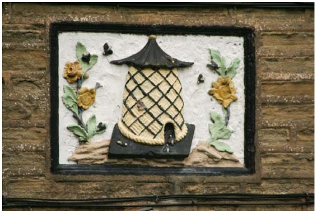
I enjoy the slightly boastful “ample fortune“… well, if you have it, why not? The beautiful carved relief plaque of the beehive over the main door – symbol of productivity and hard work – gave inspiration for the name of the pub over the road. The Beehive pub itself is an 18th century building, with a 19th century front added, and another example of the building boom of the 18th century in Whitfield.

Old School House, Hague Street. The beehive carved in relief, surrounded by Sunflowers, and crawling with characterful bees. I love this.
62 Hague Street

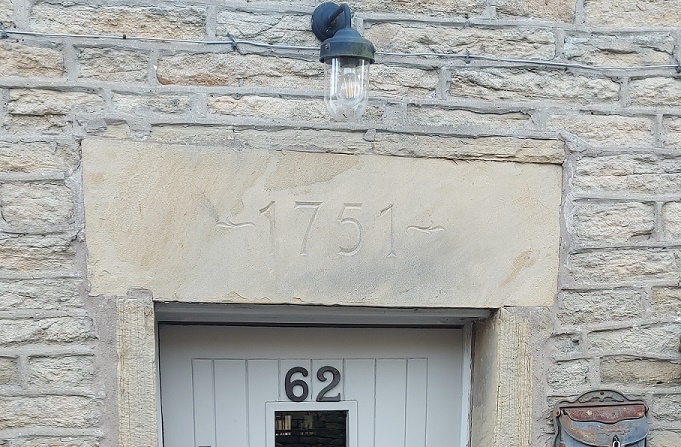
Another Grade II listed building, one of several together, and originally built as a ‘laithhouse’, that is a building made up of a house, barn and byre/shippon in one. It is a late example of the type if the date is to be taken at face value, but there you go… this corner of Derbyshire wasn’t exactly at the forefront of architectural fashion. There is also a bit of confusion regarding 62 Hague Street. As it stands now, there is a simple date of ‘1751′ above the door. However, the listing for the Grade II building notes that “No.62 originally had datestone inscribed RMS 1757” (read the full listing here). The present datestone is fairly modern, carved perhaps to replace the missing stone, but it doesn’t explain the difference in date. I thought it worth mentioning for the sake of documentation and completion.

41 – 51 Cliffe Road

So who was Joel Bennett? Born 11 April 1791 to son of George Bennett and Martha Cooper, he came from a large and important local family. He may have been the same Joel Bennet who was excommunicated from Littlemoor Independent Chapel in 1828 for “disorderly walking and impenitency” (source is here). I’m unsure of what is meant here by “disorderly walking”, but given the hotbed of radical religion that was Littlemoor, one assumes it wasn’t the Georgian equivalent of Monty Python’s Ministry of Silly Walks. He may also have bought Kinder Lee Mill in Chisworth with his brother James in 1823.

House at the bottom of Cliffe Road (4 Cross Cliff?)

This house, set back from Cross Cliffe almost at the bottom, has a wonderful datestone: stars, wheatsheaves, and a Masonic compass, with the letters ‘R’ ‘R’ ‘O’ and ‘S’. Actually, is that an ‘O’? Or perhaps a flower? I have no information about the place, nor the letters (Robinson again?), and one cannot simply knock on a door and say “What-ho… tell me about your house”. One tends to get stared at, with vague mutterings about “setting the dogs on you”, and “lunatics disturbing the peace”. Alas. If anyone has any information about this house, or indeed any of the houses, drop me a line.

Also, and seriously, if anyone knows of any more datestones that aren’t in the above list, and which date from before 1837, then please let me know. I’ll credit you, too, so you can be famous… to all 11 of you who read the blog (including Juan in Venezuela).

Oh, and some news. I’ve been working on the Glossop Cabinet YouTube account recently, and hopefully will be producing videos of me finding bits and pieces, mudlarking, talking archaeology, exploring, playing with pottery, and much more (can anyone else hear that groaning noise every time I mention pottery?). So if you like the blog, then you’ll love this. I’ll post a link asap.

Also, I’ve recently set up a Ko-Fi account which allows you lucky folk to ‘virtually’ buy me a drink if you wish. There is no pressure to do so, obviously; I do the blog because I enjoy doing it, and am constantly amazed that other people enjoy reading it (which is reward enough, it really is). However, if you do fancy buying me a pint to say cheers, I’ll never say no – please click this link, and mine’s a red.

That’s all for now I think. I’ll post something else before Christmas, possibly pottery related, you lucky lucky people (there’s that noise again). But until then, I remain,

Your humble servant,

RH

Archaeology · Oddities · Whitfield

What If…? Of Stone Heads and Stories.

What ho, you wonderful people, you.

So, despite having half a dozen half-written posts, piles of interesting objects and sherds to talk about, and a few adventures to recount, I want to try something a little different today. “Oh no!” I hear you cry. But fret ye not, gentle reader, for it is still archaeology, it is still Glossop based, and it is still interesting. But it is a little… quirky. You’ll see what I mean.

I have a friend who is a writer, and quite a good one at that. He has often mentioned that stories usually start with what he terms a “What If?” moment, where something – often an object – presents itself, and the question is posed “what if…?” From there the story grows, based on and around that one question. The answer that comes doesn’t have to be ‘real’, it is fiction after all, but it has to be possible. What if a house was haunted? And what if the house fell down? And what if a brick from the house was haunted too? And what if a dashing archaeologist took the brick home to write about it on his extremely popular and incredibly interesting blog? What if…?

Archaeology, I think, uses a similar technique. An object is excavated, and the interpretation – the story – begins. However, where we differ from writers is that we base our ‘what ifs…?’ on evidence and supposition grounded in data. The interpretation, in this sense, has to be ‘real‘, although it is only ‘real’ for as long as the data supports it. Sometimes though, It’s fun to play “what if…?” – and here we join today’s post.

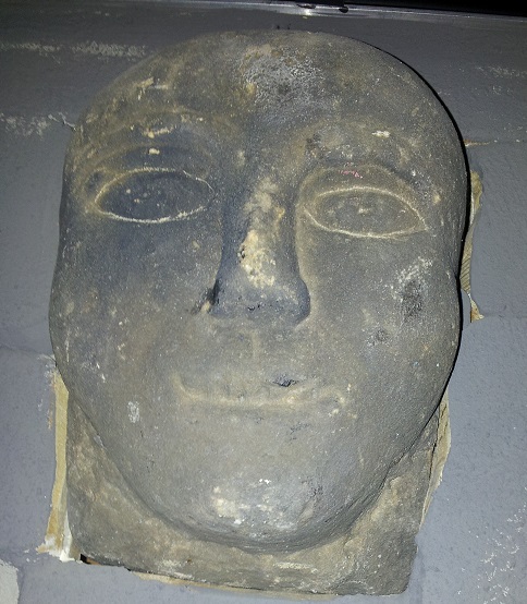
A stone head displaying all the characteristic features, including almond eyes. This one was allegedly found on Mouselow, and now lives on a wall in Buxton Museum

Stone heads. A lot has been written about them. They are cursed and evil. Or they are warm and friendly. They are ‘Celtic’ (i.e. Iron Age or Romano-British) in date. Or they are medieval or early modern in date. Or a combination of both. They represent an unbroken pre-Christian tradition, and an aspect of the whispered ‘Old Ways‘. Or they are simply folk art, and just decorative. Or they are magically protective (that wonderful word, apotropaic, again). Or both. Or neither. A brief trawl of the internet gives a lot of different sites and opinions, ranging from the scholarly and the more open minded, to what can only be termed outright nonsense.

Whatever they are, carved stone heads are a feature of this part of the Pennines – from Longdendale, over the hills to West Yorkshire, and up to the Calder Valley. I actually have a serious project that is looking at them; cataloguing known examples from Glossop and Longdendale, and trying to place them geographically, as well as giving some sort of date to them. There are at least 23 examples from the Glossop area, with more doubtless waiting to be uncovered. But it’s an ongoing project, and not really ready to publish – here, or anywhere else for that matter – and I just keep chipping away at it. It was during the course of trying to map where they were found, that I noticed something very interesting.

Stone head in Old Glossop. Image stolen shamelessly from the Old Glossop website (follow this link – the website is very good)

Before we go any further, I should state that my personal belief is that most of the stone heads are medieval or post-medieval in date (indeed, there is a record of them being carved in the 19th Century). That’s not to say that Iron Age ‘Celtic’ examples don’t exist (one was found at Binchester Roman Fort, in County Durham in 2013), it’s just that it is very difficult to date them as they usually don’t come from any secure archaeological context, and basing a date on ‘style’ or method of carving, as has happened in the past, is notoriously dodgy. That stated, there is the possibility that I might be wrong. And this led to my ‘what if…?‘ moment.

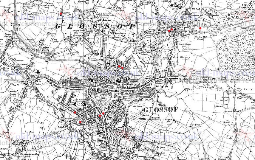
Back to the find location, sadly the majority of the heads are simply “found in Glossop area“, and thus have no exact place. But from various sources, I was able to identify where some of the heads were found. The distribution map is below:

1:10,000 map of Glossop. The Find spots – where the heads were found – are marked in red.

They seem to be dotted all around the area: Mouselow, Manor Park Road, several in Old Glossop, etc. However, looking at the above map, I noticed there was a distinct grouping in Whitfield – four of them centred around Slatelands Road and Hollin Cross Lane. Hmmmmm… let’s have a closer look, then.

Here is the Whitfield group on the 1:2500 map.

Duke Street, Pikes Lane, St Mary’s Road, and Slatelands Road. Geographically, they are in the same tangle of roads in that area. But the heads more than likely pre-date the Victorian roads, so we need to strip them back. What was there then? Well fields, mainly, though the medieval track from Simmondley to Glossop ran through here (that blog post is coming, I promise!). And before that, the Roman road also ran through here, along Pikes Lane, before kinking over Long Clough Brook and onto the fort and settlement at Melandra.

And then, the “what if…?” hit me.

For the sake of a good story, what if these heads actually were Iron Age or Roman in date? What could this cluster mean?

Looking again at the area stripped of the Victorian houses, it’s very clearly a promontory, a high plateau that runs between two brooks – Glossop Brook to the north, and Long Clough Brook to the south. In the Iron Age, they liked their elevated places – Mouselow, which dominates the area, is a classic Iron Age hillfort, and others exist nearby, at Mellor and Mam Tor. One only has to look at St Mary’s Road from Harehills Park to see how steep those slopes are (try doing it pushing Master Hamnett in a pram with a load of shopping from Aldi). And on the other side, who hasn’t cursed Slatelands Road halfway up, gasping for breath. This is a very real landscape feature, completely masked by later development, but one which would have been very visible back then. This would have been particularly true where the peninsular narrows at the west, leading down to the junction of the two brooks. This too, is significant.

Throughout prehistory water was a sacred thing, and was considered ritually important. A spit of land, elevated, defined by water and ending in the confluence of two bodies of water, would have been hugely significant. Actually, a perfect place for an Iron Age temple or shrine, perhaps one devoted to the ‘Celtic head cult’ as suggested by scholars such as Dr Ann Ross (in her Pagan Celtic Britain)? Indeed, the North Derbyshire Archaeological Survey notes that the number of heads in the Glossop area “might suggest a cult centre” based in the town in the Romano-British period (Hart 1984:105). It has been suggested that the heads are sometimes associated with liminality and boundaries, and were protective. What if they were they placed facing down the peninsular, to mark out the sacred space, and to defend it?

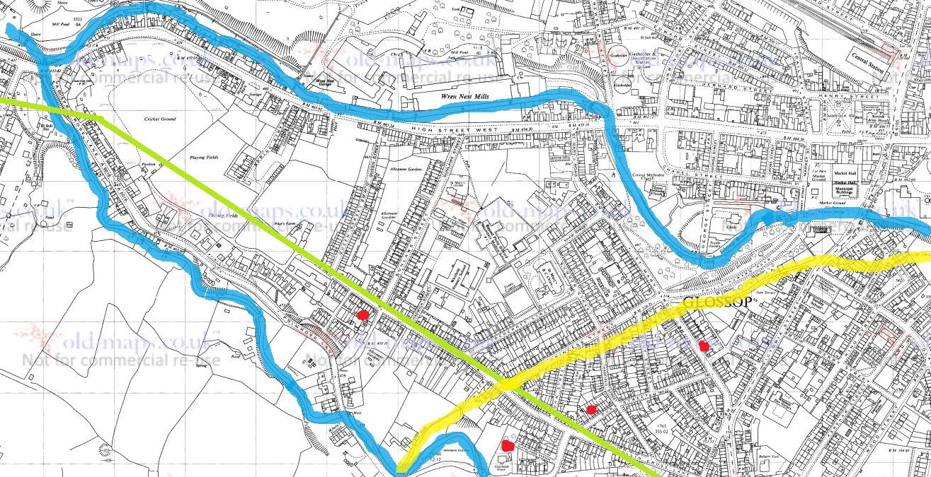
The Roman road moves through this promontory, sticking to the high ground away from the valley floors and marshy terrain, as the Romans preferred (see map below). But what if the location of the possible shrine or temple influenced the choice of road location, ploughing through the sacred enclosure, perhaps to make a point about Roman dominance?

The location of the heads in relation to the landscape. The blue is the waters of Glossop Brook (north) and Long Clough Brook (south), forming the spit of land. The yellow line is the medieval trackway, and the green line is the course of the Roman road.

What if…?

Now, I’m not suggesting for a moment that that the above is absolutely true; this is a wild flight of fantasy, and pure fiction – a story. Indeed, doubts are being raised about the reality of the ‘Celtic head cult’ theory in general. But it is a possibility, at least: an archaeological what if…? However, if that isn’t the answer, there still remains the issue of why four stone heads were found in a cluster in this area. What is going on?

If we return to my original thought, that the heads are medieval or post-medieval in date, might they be related to the Simmondley – (Old) Glossop trackway in someway? If we look at the map above, we can see this track (marked in yellow) runs broadly along the line of Princess Street. And just to the east of the three of the heads run along the same alignment. Is this significant? What if people somehow, and for some reason, deposited these heads to the east of the track? But why? Well, I came across a possible reference to just such a practice in this area – Clarke states that “Oral tradition in the High Peak of Derbyshire suggests heads were buried as charms beneath newly-built roads, presumably to keep permanent watch over them” (1999:286). He cites no sources for this “oral tradition”, but this type of apotropaic function – preventing witchcraft and promoting good fortune – is associated with carved heads all over the United Kingdom (Billingsley 2016). Perhaps, then, we are seeing the ritual deposition of carved heads as part of the road building tradition.

What if…?

Heads
A pair of Whitfield Heads. These are at the end of Kershaw Street… and that is all I know about them. It’s on my ‘to do’ list, don’t worry.

No, it is a mystery, and ultimately we are left with questions for which there are no obvious answers. Three of the heads are in Manchester Museum, and the fourth presumably in the hands of the owner/finder. I will have to go and see them, as that might help in dating. As I say the project is ongoing, and any comments or help in the area would be greatly appreciated. Do you know of any stone heads? Do you have photographs of any? Or stories – they seem to attract folklore and superstition like nothing else! Please contact me in the usual way – email me, or through twitter ( @roberthamnett ). Or just come and find me in the street, as people are increasingly doing… so much for pseudonyms and anonymity!

I do hope you enjoyed the little flight of fantasy, but we’ll be back to business as usual next time – the sherds are mounting up! Until then, look after yourselves and each other.

And I remain, your humble servant

RH

References:

John Billingsley – Instances and Contexts of the Head Motif in Britain

David Clarke – The Head Cult: Tradition and Folklore Surrounding the Symbol of the Severed Human Head in the British Isles. (Unpublished PhD Thesis, accessed here)

Anne Ross – Pagan Celtic Britain: Studies in Iconography and Tradition

Bench Marks · Stones of Glossop · Towns of Glossop

A Bevy of Boundary Stones

Ho! Ho! And if I might dare, What Ho! A shortish one today, and actually one that is something of a relief, if I’m honest. Like the last post, this one has been years in the making, but this time for all the wrong reasons… all will become clear in a moment, but for now let’s crack on.

As the title suggests boundaries are today’s topic, apt as we hurtle to the Winter Solstice and the shortest day – that anciently observed boundary between the old year and the new. Boundaries such as these are often held to be dangerous places as they are a liminal space – neither one thing nor another, but somewhere in between. However, boundary stones in particular I find fascinating and strangely appealing objects; there is something very grounding about them in that they mark in a clear, permanent, and fixed way, an imaginary line. On one side ‘X’ and on the other ‘Y’, and there is no argument – the somewhat liminal boundary is made visible and real, and so it is the case with our stones today – three stones placed on bridges over various waterways delineating the townships that make up Glossop

All three, it seems, were carved and installed at the same time, and all are quite old – early Victorian. The first of the stones is the easiest found – Victoria Bridge in the centre of Glossop.

Bount
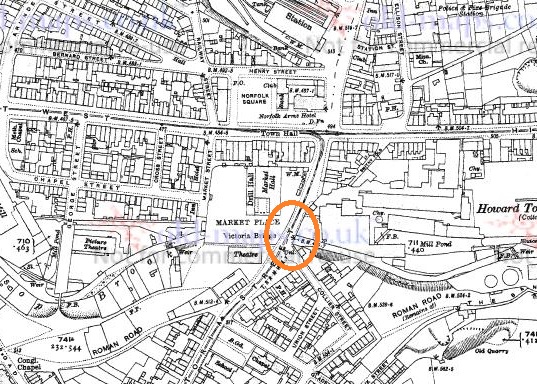
Station at the top, above the High Street crossroads. The bridge over Glossop Brook, and the stone, is circled in orange. Glossop is north of the Brook, Whitfield is south. 

And here it is in real life.

Boundary St
Victoria Bridge. Wetherspoons is in the background, and Glossop Brook runs beneath.

The bridge, and the stone, stand over Glossop Brook, which disappears under the market place and carpark, and the line carved between the words Glossop and Whitfield is the centre line of the brook below. Victoria Bridge was built in 1837, the year Queen Victoria ascended the throne, hence the name. This new bridge replaced an old and narrow hump-backed pack-saddle one. Indeed, the original line of the road that led over the bridge, down Smithy Fold, and along Ellison Street is traceable, and is preserved particularly in the buildings of the Brook Tavern, Cafeteria, Glossop Pizza, Balti Palace (all built in 1832). I have a blog post almost finished that looks at this area in more detail, so I won’t go into it here.

Looking closely, the inscription “Victoria Bridge” and the date “1837” are in a different font and slightly larger than the other lettering on the stone, and are more cramped, and it seems they were added at a later date. Indeed, compare this stone to the one below, and you can see they both once looked the same. 

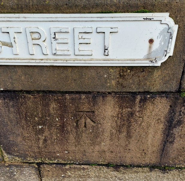
And of course, it wouldn’t be the Glossop Cabinet of Curiosities without a bench mark, this one on the bridge and just to the left of the boundary stone. 

Victoria Bridge
This is what 495.7 ft above sea level looks like.

The next stone is to be found on Charlestown Road, on a bridge over Long Clough Brook – it’s very much a blink and you’ll miss it kind of affair, even if you are walking. 

Bounty
Turnlee and Charlestown Roads join at the top, with the boundary stone circled in orange.
bound3
Here is the bridge over Long Clough Brook on Charlestown Road. The stone is visible.
bound1
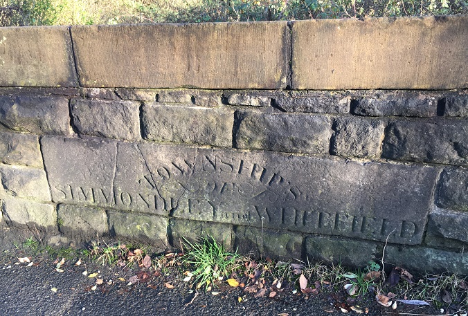
Here it is in close-up. Can you spot a mistake?

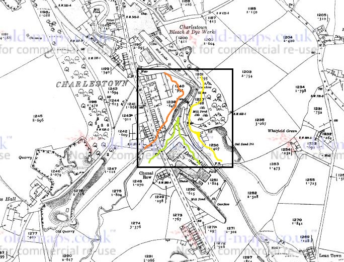
This stone follows the same formula as the Victoria Bridge stone, but is slightly rougher in execution. It seems to have been reset into a rebuilt stone wall at some stage, as it doesn’t really match the coarse  surface of the stone around it, and this resetting might explain the cracking. It also has an inexcusable mistake… there’s a bloody apostrophe after ‘township’! It should read ‘TOWNSHIPS’, the plural of township, but instead it reads that ‘Township’ owns something called an ‘of Simmondley and Whitfield’! Also, although it states that this is the boundary between Simmondley and Whitfield, it technically isn’t. This is the border between Chunal and Simmondley, but it seems that for administrative purposes, Chunal and Whitfield were often lumped together. The confluence of Bray Clough (from Gnat Hole) and Long Clough Brook (just east of the boundary bridge) is actually the meeting of the three townships of Chunal, Simmondley, and Whitfield, here:  

bounty2
The three townships illustrated at the junction of Bray Clough Brook and Long Clough Brook. Chunal in green, Simmondley in red, and Whitfield in yellow.

So far, so good.

Now, the third and final stone was a bit more of a mystery. According to Neville Sharp (Glossop Remembered p.184 – a great book, by the way, well worth seeking out – here for example, but order it from Bay Tree Books on the High Street, of course), a stone similar to the one on Victoria Bridge stood on the bridge over Hurst Brook which forms the north eastern boundary between Glossop and Whitfield. That is until it was washed away in a flash flood.

Bound4
High Street East at the top, with Derbyshire Level running from the Royal Oak off the map at the bottom. The word stone on the bridge over Hurst Brook is circled.

Then, whilst doing some research, I came across a reference to the stone and made a note in my notebook that until at least 1977 the stone stood next to the entrance to Golf Course. Annoyingly, I didn’t take down the reference and it’s taken me 3 years to track down the source of the information. Three years! Such is the level of detail and dedication I devote to this blog in order that you, gentle reader, can revel in such a fascinating subject as “bits of old plate” as it was once described by the person who runs the ‘Official Glossop‘ twitter account. Honestly, the nerve of some people…

So I re-found the source – this website – and blow me if it didn’t have a link to photographs of the stone taken in 1977:

Boundary Stone 1 (1977)
Entrance to the golf course on Derbyshire Level, the boundary stone bottom centre, in the glorious sunshine of the summer of 1977


Boundary Stone 2 (1977)
Close up of the boundary stone with part of the word ‘Glossop’ visible. Please note that I don’t have the copyright to these photographs, and make no claim to such, they are merely ‘borrowed’ from the above site.

The stone was presumably recovered, in its broken state, and set up on the side of the Golf Club entrance, and whilst it doesn’t look like there is a lot left I went to have a look.

Boundary St1
The same view as the first photograph above, missing the important piece.

Alas… the stone is no longer there. I had a good look around at all the stones that might be a possibility, but to no avail. I suspect that someone has taken it – it was a nice piece of stone after all, but it is a shame. All is not negative, though, and from the 1977 photograph we might suggest where it originally stood; the fact that the fragmentary word ‘Glossop’ is visible at the left hand end of the stone means that it could only have stood at the eastern side of the bridge, closest the golf course, for it to make geographic sense – Glossop is north, Whitfield is south at this point. Here, in fact:

bound2
Here. You can see the modern(ish) bridge that must have replaced the one that was washed away. Here, Hurst Brook separates Whitfield (right) from Glossop (left).

Its fragmentary nature also suggests that more of it lies in the stream bed – I had a look, but couldn’t see any likely stones, but perhaps next summer I’ll have a poke around. 

Right ho, that’s all for this time. Hope you enjoyed a ramble around the boundaries, and in fact I am writing a blog post that actually covers the boundaries of medieval Glossopdale based on a 13th century perambulation. I’d also like to do another that looks at the boundaries of all 10 townships of Glossop as they are in the Domesday Book, which could be a bit of fun. ‘Could‘ being the operative word here. And ‘fun‘ being an entirely subjective concept, I realise. But you, kind and gentle people, know what I mean… after all, you’re reading this. Please drop me any thoughts or hints, even to point out my mistakes, or the fact that I need a haircut. Take care of yourselves and each other, have a very merry Christmas, and until next time, I remain.

Your humble servant, 

RH

Archaeology · Whitfield

Pressing Matters – Of Cheese and Wills

Good evening gentle readers. I say good evening, for this is when I am writing, but it could be anytime you are reading this. And indeed anyplace… which worries me slightly. Anyway, moving swiftly on.

Recently, I posted a hotch-potch, pickle-type post, that looked at the cheese press I found that was being used to fill up a hole in a trackway. Well, some interesting developments have, well… er… developed.

Firstly, it seems that the whole cheese press is present, which is excellent news. But alas it is broken into two pieces, which isn’t such excellent news. Still, the fact that it survives at all is pretty impressive. Secondly, and even more impressive, I think I might have identified to whom it belonged, which is amazing if true. Please note the use of the phrases “I think” and “if true“… I’ll leave it to you to decide.

Firstly, then, the press.

It’s complete, as in it’s all there, although as you can see it is sadly broken across the middle. It measures 94 x 43 cm, and about 10cm deep, so it’s not huge – and these things do come in huge sizes. I had a poke around mini excavation, just to reveal the edges, and to assess how much was there, but I didn’t want to dig too far – it is filling a large hole in a track after all.

Press1
Nice to see the whole thing – you can just make out the corresponding beam hole on the right.

Master Hamnett helped reveal the press, of course… any excuse to get dirty.

Press2
Master Hamnett ‘helping’ with the excavation and the photographs

It’s fantastic, and I honestly think that this needs to be removed from the road and put on display somewhere; it is a wonderful piece of evidence for life in 18th century rural Whitfield that deserves to be treated better than it currently is.

Right then, so who owned it? Well, I was reading through a collection of Glossop-based 17th and 18th Century wills the other evening.

Before we move on, perhaps we should examine that statement. I have just read it back, and the thought occurs to me… mine is perhaps not what you might call a ‘normal’ life. I mean, here I am, on a Friday night, reading 300 year old wills, and getting excited over some new bits of pottery I found yesterday. Sometimes it’s good to take stock of one’s life… and other times it’s good to simply leave one’s livestock alone.

Anyway, back to the wills. They have been digitised as part of the North West Derbyshire Sources project which is a truly remarkable source for local history and genealogy in this area, and filled with all kinds of information – if you don’t know the website, please do have look. The will that caught my eye was that of John Cowper (Cooper) of Whitfield, and dated 1750. The actual will is fairly bog standard, but is genuinely fascinating as it contains, in a nutshell, the contents of an average well-to-do household. Cooper was someone who we would now perceive as comfortably middle-class, but was then known as a yeoman farmer; someone who owns a small amount of land freehold (paying no rent), and who earns his living from it. I won’t reproduce the full preamble here as it is a wall of text – but it well worth a read (the full transcription is to be found here – it’s alphabetised, so look for John Cooper of 1749/50). However, the contents of the house is as follows:

Item Value (£ s d)
Imp/ Purse & Apparell 7    0    0
A large Bible & Clock 3    0    0
Two cows 6    0    0
A cupboard & table 0  15    0
Two coach chairs 15s 12 chairs 10s 1    5    0
One Fire Iron tongs, 3 bread Irons Fire Shovel & Brigg 0  15    0
One little Fire Iron, smoothing Iron Clever two Hand hooks & Spittle one frying pan 0    3    0
One Warming Pan a skellet a brass pan a brass pott & saucepan one Lead, Lead weight & Mustard Ball 0  15    0
8 Pewter Dishes one Tankard 1 Cup 4 porringers, Spoons 0  14    0
Books & Linnen Meal Cheese & Bacon 4  17    0
One Bedsted & Bedding & a little Cupboard ith Parlour 1    8    0
One Bedsted & bedding in the long Chamber 2  10    0
One Press 1  10    0
A Long table & one little oval table ith parlor Chamber 0  17    0
One bed & bedding ith Chamber over House 1    5    0
One meal ark 8s one Chest 10s one little chest 6s one Desk 5s one Box 1s ith same Chamber 1  10    0
One Cheese Tubb 5s one kimlin 2s Cheese fatts & other wooden ware 5s & one cheese press 3s 0  15    0
One little Ark in the Porch 1s 2 Iron potts 2s a Glass case two fall tables 2s a kneading trough 1s 0    6    0
One Shovel Mattock & Bill & Dock fork & Ax 0    3    0
One Stock of Bees at Thomas Cowpers 0  10    0
Huslement 0    5    0
46    3    0
In Bills 88    2    0
134  5    0

The items listed, then, are those that are considered of value in the mid 18th century, and if you look, it’s largely the things that we would take for granted. Imagine someone doing this to your house – have a look around. Would they mention your pots and pans? Or your fire irons (assuming you have a fire – everyone in the 18th century certainly would have). Or your bed linen? Or your cheese and bacon? It’s bizarre, yet it also makes sense. There were not many frivolities then; would bacon count as a frivolity if you had raised the pig, killed it, salted it and stored it? No, it would be a resource that you had earned. Your iPad would be listed, but Cowper had a clock (along with a large Bible, valued at £3 [£350 in modern money]. Your car would be listed, but Cowper had two cows and a hive of bees valued at £6s10 (£758.35 in modern money). Your all-singing, all-dancing, ride-on, lawn mower might be listed, but Cowper had “One Shovel Mattock & Bill & Dock fork & Ax” valued at three shillings (£17.50).

Some of the items listed needed a little further exploration. For example, the ‘Mustard Ball‘ valued with the rest of the pots and pans from the kitchen threw me. But it turns out that they were literally balls of powdered mustard.

tewkesbury-mustard-balls
Traditional mustard balls. Image stolen from the Tewkesbury Mustard Company website – there is a link to the site below… fascinating stuff.

The seeds were powdered, and mixed with some form of binder – wine, vinegar, honey or raisins, for example – and when needed, slices were taken and soaked in a liquid to soften them (in vinegar, or verjuice, for example – the sour juice of crab apples), and added to food. They are still made, as they were 700 years ago, by a company in Tewkesbury (the Tewkesbury Mustard Company) who make the best, apparently (and I have no reason to doubt that). Thanks also to this fascinating blog about historical food for the information.

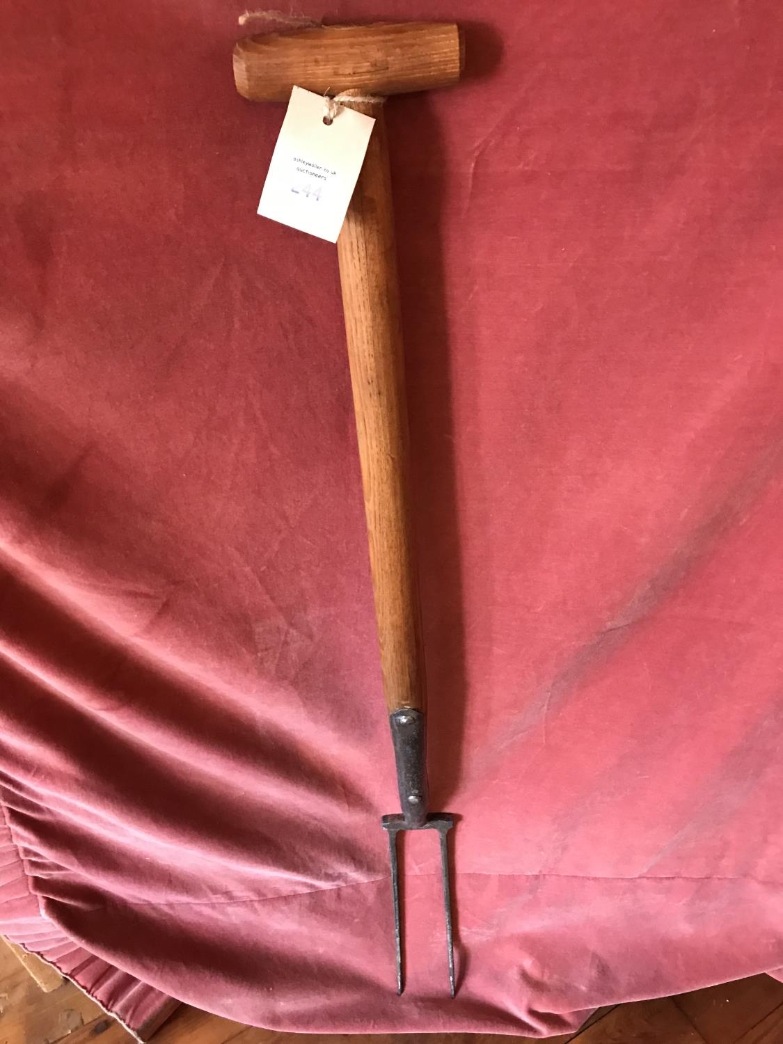
The above mentioned “Dock Fork” was also not something I had encountered before; a little research brought forth this:

Dock Fork
Dock fork, from the easyliveauction.com website – this one sold for £25… a bit more than the £17.50 it was valued at, with other implement, in 1750.

As anyone who has ever weeded a garden will know that docks are difficult buggers to remove, and yet are brittle, breaking and leaving root fragments that will flourish into full bushes of weeds in weeks. A problem to which the answer is a dock fork, that allows you to lift the whole plant without breaking it. Obviously.

The important bit for our purposes here are those items listed that are used in cheese making, and specifically the cheese press. As you have seen, it’s not a small item, nor is it something that everyone would own – it’s a specialist implement used on much more than a domestic scale. It, and the other cheesemaking equipment mentioned in the inventory, indicate the relatively large-scale making of cheese to be sold, and perhaps supplying everyone in the local area. As perhaps only a single farm in each area would have one, I would suggest that the one mentioned in John Cowper’s will is the one I discovered a while back, and which is now filling a hole in the track. I realise that it is impossible to prove, after all the stone has no provenance, nor do we have an address for John Cowper other than Whitfield. But Whitfield as a settlement was concentrated along Cliffe Road and Hague Street – the old road from Hayfield to (Old) Glossop, and largely around The Beehive (it arguably still is) – then it is likely that Cooper lived in this area too, and thus his cheese press has not moved far. Anyway, I’m convinced. The big question is… are you?

Whit
Whitfield – the medieval and post-medieval heart of the settlement along the main road from Hayfield to (Old) Glossop. For orientation, The Beehive is marked by the large orange arrow. The oldest building in Whitfield, Hob Hill Farm – which has a datestone of 1638 and associated 18th century buildings – is marked by the green arrow.

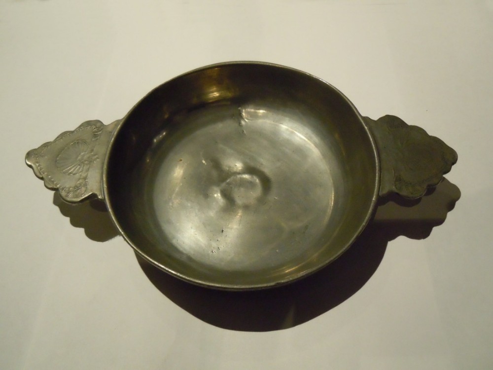
However, although we might not be able to pinpoint his house, we do have a way of working out the type of house Cowper lived in. Essentially, the people who were assessing the worldly goods of the testator went from room to room, recording what was in each, and thus the inventory provides us with a sort of snapshot that allows layout to be reconstructed. So, on the ground floor we have the Kitchen/Living Room. This was where the main fire was, and all the cooking and eating equipment was, including “One Warming Pan, a skellet, a brass pan, a brass pott, & saucepan” and “8 Pewter Dishes, one Tankard, 1 Cup, 4 porringers, Spoons“.

Porr
A 17th century pewter porringer – a bowl with a handle used for stews. They were incredibly popular in pottery as well as pewter until the 19th century, when meals became less ‘wet’ and plates became more popular.

This was a large long room – it contained “A cupboard & table“, as well as “Two coach chairs, 12 chairs” (which may be a mistake, as that seems a lot) – and had the fire at one end, and the door somewhere, possible in the middle of the long wall. There also seems to have been a pantry – probably just a built in cupboard – which contained “Books & Linnen, Meal, Cheese, & Bacon“.  Next to this is what is termed the ‘Parlour‘ in which there is a “One Bedsted & Bedding & a little Cupboard“. Moving up the stairs to the first floor, we have the Master Bedroom, termed here the ‘Long Parlour‘, and which was presumably over the Kitchen/Living Room, and containing “bedsted & bedding” and a “press“. Next door is the ‘Parlour Chamber‘, literally the bed chamber over the Parlour, which contained “a long table & one little oval table“. The next floor up, the attic room, was over the whole upper floor and is named the “Chamber Over House“. It containing “One bed & bedding” and “One meal ark, one Chest, one little chest, one Desk, one Box“. The ‘meal ark’ mentioned here, and the ‘meal’ in the Kitchen is oatmeal, used for bread or making oakcakes, and traditionally kept in a wooden box.

Meal
A 17th Century meal ark.

So then, five rooms in total, centred around the hearth and kitchen, and with three bedrooms. This layout is a classic of its kind – very simple, very basic, but very functional. And I have to say, quite cosy. There may have been outbuildings, perhaps containing the cheese making equipment, and certainly a ‘Porch‘ is mentioned, containing “One little Ark, 2 Iron potts, a Glass case, two fall tables” and “a kneading trough” for making bread.

Kne
A kneading trough, in which dough was kneaded and left to prove.

This type of house is described as a “Two Unit” type – essentially one large room divided into two rooms, one large and one small. The Handbook of Vernacular Architecture by R. W. Brunskill has a dozen different configurations of this type of building, and Cowper’s house could fit any one of them. Vernacular architecture refers to buildings on a domestic scale that use local building traditions, and local materials, rather than ‘fashionable’ architectural designs such as the grand halls and houses of the wealthy.

Will
The basic Two-Unit house plan. Cowper’s house was probably along the lines of ‘h’, although any could fit to be honest.

It’s just a pity that we can’t identify the actual house.

So there we are, cheese presses and wills… hope you enjoyed it. As always comments are very welcome, and I would be glad to hear from you. Please look after yourselves and each other, and until the next time, I remain

Your humble servant,

RH

Archaeology · Pottery · Whitfield

A Possible Pair of Post-Medieval Paths, a Potential Pub, and Plenty of Pottery.

As I have said many times before, I do love alliteration. What ho! and all that. I trust you are all keeping well in these odd times? Well, now this is a monumental post – it is precisely three years to the day that I made the first post on this blog (you can read it here if you want). When I first started it I had no idea what it was going to be, other than I had some interesting bits and pieces that I wanted to share, and which I thought other people living in Glossop moght be interested in. The blog is still pretty much that in aim – bits and pieces – and I was right… there are lots of you out there who seem to enjoy the ramblings of a man who gets excited by bits of old rubbish. So thank you, you wonderful people, for reading, and here’s to many more blog posts. Now, on with the show. RH

During the lockdown, Master Hamnett and I have been taking a daily constitutional up and around what has become known as the “secret passageways”. Overgrown and wild in places, even for a man of modest size such as myself it is a mysterious place, but to a 4 year old it is indeed another world. Naturally, I have been keeping an eye open for bits and pieces of history, and I think I have a story to tell. Possibly. Well, I certainly have some pottery to show, so there’s that!

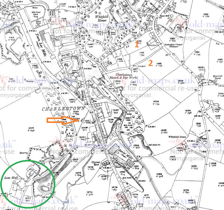
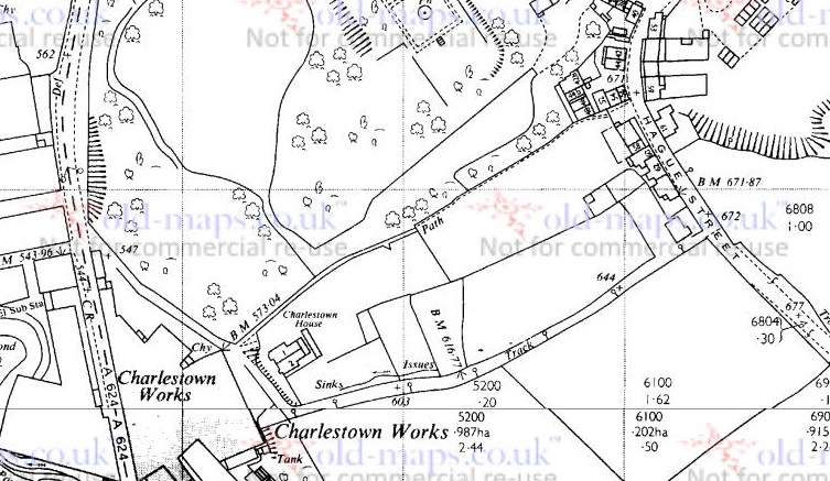
The route we walk is essentially along Hague Street, down one track to Charlestown Road, along, and then up another back to Hague Street. We often continue on and round if it’s not raining, but always walk these paths, which I have helpfully marked Tracks 1 and 2 on the map below:

M6
Tracks 1 & 2 at the top. Ignore the arrow and a circle for now… all will become clear!

The tracks and immediate area are more clearly shown on the 1968 1:2500 map

m10
It’s a nice and short circular walk, if anyone fancies it.

The tracks are interesting in themselves in that they are once again an example of what I call the fossilisation of trackways – they are older tracks that no longer perform a function as such, but are preserved as footpaths. Certainly in this case as it makes no sense to have two tracks mere metres apart going between the same places. Instead, I think they are preserving the memory of a single older track, which I suggest below is Track 2, potentially the more interesting of the two. But I’m getting ahead of myself.

Track 1 runs down the side of this house, which was originally a pub called the Seven Stars (hence the sign on the door frame, although the sign above the door is a mystery… if you are reading this and own the house, could you tell us?).

M7
The one-time Seven Stars pub – I always feel a bit weird photographing people’s houses, but this is visible from the road, so it’s not as though I’m sneaking around gardens.

I know nothing about this establishment, but it was probably a beer house. As a reaction to the widespread and dangerous consumption of cheap gin – the so-called ‘Gin Craze’ of the late 18th century – the government encouraged more beer drinking (beer being considered relatively healthy) by allowing householders to open up their houses to brew and sell ale. These private houses became known as beer houses, and the individual paid a small fee to the local magistrates in return for an annual license allowing them to sell beer, but not the wines or spirits that the normal pub or inn could. If anyone has any information about the Seven Stars, please do get in contact.

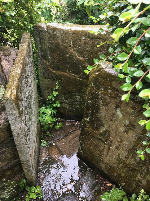
Just here is a series of upright stones presumably placed to stop horse riding or cycling. The gap between them is very thin; I might have put on a little weight during lockdown, but even I had to squeeze through.

M22
Breath in!

Carved onto one of these uprights are the intials ‘M.D.’ – I must have walked through these 100 times and never noticed the letters before, but the light and the rain were just right this time.

M23
And as you all know by now, I can’t resist carved graffiti.

Further down the footpath I noticed a reused quern or grind stone – possibly Victorian, but I suspect earlier – being used as a coping stone for the wall. And why not? It’s the perfect shape, and may well have been hanging around for centuries after being used to grind wheat into flour.

M9
The worn central hole is visible, and it’s possible the other half is around here somewhere.

About halfway down, you come face to face with more of those upright stones, although in this case I can only assume they were put there to stop a headless horseman! Honestly, they are quite unnerving.

M19
Not at all creepy and gravestone looking. Nope. Absolutely not.

The path continues:

M18
Master Hamnett on the final stretch down to Charlestown Road. At the end of the path, in spring, there is a truly spectacular spread of wild garlic.

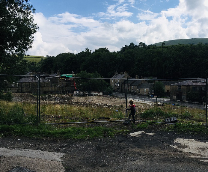
Until we arrive at Charlestown House, and the Charlestown Works that were – now demolished and awaiting houses.

M30
The site awaiting re-generation. The hairpin bend where Charlestown Road meets Turnlee Road is visible. Whitley Nab in the background right, Casa d’Italia left (very nice pizza, highly recommended). Dead ahead is Lees Hall, which is important… stick around!

So, here’s the pottery:

M3
A small assemblage of fairly typical Victorian bits, with a potentially earlier piece.

Top row, from the left: a base of a saucer or small plate; a huge chunky handle belonging to a large jug; a base of a glass jar or jug, or possibly from a tankard – it’s nice and decorative, but not expensive. Next is a fragment of a pedestal footed drinking cup, which is again fancy, but not especially expensive, it being just glazed earthernware. Then there is a rim to a large plate of some sort, being about 30cm in diameter.

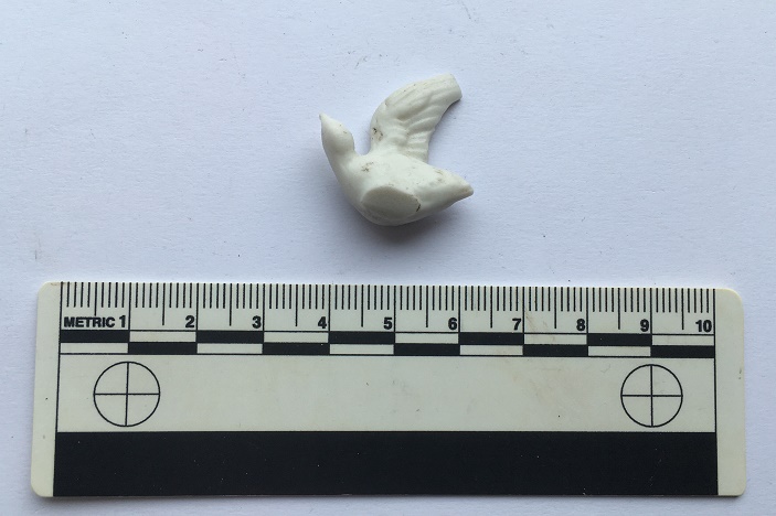
The lower row from the left: a fragment of a stoneware bottle, a chunk of a pancheon, and a fragment of a manganese glazed jug or similar thick walled vessel. Then we have two pieces of blue and white earthernware, and a base of a tea cup. There is nothing massively interesting, and it all seems to be Victorian in date, as we might expect… except for the manganese glazed jug! This is, I think, earlier – perhaps early 18th century. It’s quite characteristic, and although there was a revival of manganese glazed pottery in the Victorian period, this glaze is of relatively poor quality, and the fabric (the actual clay of the pot) is quite rough, both of which suggest an earlier date. Then there is this lovely bit of pot; it’s a china dove, shaped to fit onto what would have been a tasteless Victorian jug or bowl – you can see the flat bit where it was joined to the vessel it flew away from.

M4
Found lurking below some dandelions.

Then there was this:

m20
A bottle top

A screw bottle top, probably from a beer bottle or similar, and dating to the early 20th century. I love these things, and have blogged about them previously – here, for example. Unusually, this one doesn’t have the drink makers name or logo on the top, just the name of the bottler – R. Green of Leigh.

M21
Always nice to see.

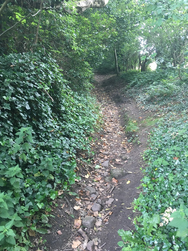
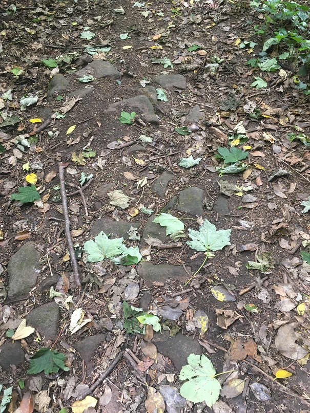
Moving on to Track 2, there is a noticeable difference between the two. This one is more of an actual track; it is certainly wide enough to drive a horse and cart down it, and it seems to have had a surface at some stage. It is also deeply worn in places, which can be suggestive of an older trackway.

M26
Possibly worn by traffic, the track is quite deep in places.

M27
It’s not much to look at, but this is the surface of the track.

I’d love to put a trench across this track to see how it was made up.

Further on, it has what seems to be a late 19th or probably early 20th century cast-iron streetlight, which is interesting and spookily out of place now, but suggests strongly that it was used as a ‘proper’ track until fairly recently.

m24
It has seen better days, but there it is, slowly being overtaken by nature.

m25
I can’t work out if it is gas or electric… further research is needed.

Right next to the streetlight is a gateway into a seemingly random field, and a benchmark on the gatepost – it’s been a while! This one – 616.77 above sea level – is a late addition as it is only marked on the 1968 1:2500 map. There was another benchmark marked on the opposite side of the track – 622.6ft above sea level – but it’s long gone (you can see it in the map above).

m13
The bench mark. This is what 616.77ft above sea level looks like.

The track continues until daylight is reached.

m32
I love this shot… artful (courtesy of the iphone filters, not talent on my part). Mrs and Master Hamnett providing the scale.

The top of the track, where it joins Hague Street again, is the site of the original Whitfield Methodist chapel – it is visible on the 1880 1:500 OS map:

M28
The chapel is clearly marked.

Built in 1813, it had seating for 200 worshippers, and at one time was the home of the pulpit from which John Wesley had preached in New Mills (as discussed in this post). There are more details about the chapel on the Glossop Heritage webpage.

It was demolished in 1885, and the site is now occupied by a private house, but there are some interesting re-used stones on the trackway which almost certainly came from the chapel. The one indicated by the arrow in particular seems to have been a window frame – originally it would have laid upright, and you can see where the wooden frame was bedded in, and possibly a cross bar set into the stone.

M29
I love Microsoft Paint!

A closer look reveals what might be a mason’s mark. Possibly… but then I really rather badly need glasses.

m31
Squinting, after two glasses of wine, and with the eye of faith…

So then, the pottery:

m14
Fairly standard stuff, but still nice.

Top row, left to right: a fragment of a large stoneware vessel with a cream glaze. I have photographed it showing the interior – it is roughly finished, and you can see wiping marks, and it probably came from a large cider flagon.

Next is an annular ware bowl or similar type, with the characteristic horizontal linear bands around the rim and below. Abrim from probably the same vessel is above it. Despite it looking 1950’s, this stuff ranges in date from the mid-18th century to the late Victorian; this is, I think, early 19th century. Next is a sherd of a cream ware jug, this being a part of the spout – you can tell by the twisted curve of the rim – again, early 19th century. Next is a stoneware flaring rim to a large jar, Victorian in date. Next we have a sherd of black glazed pottery which, I think, might be 18th century in date – the glaze seems to be lead based, which it isn’t in the Victorian period, and the fabric is very red, which is also common in Black Ware of the 18th century. I’ll post some more about this in the future – I’m actually trying to put together a crib sheet for pottery identification for this part of the country which some of you might be interested in (I know, I know, stop groaning… you don’t have to read this blog, you know. And I did say ‘some of you‘!). Beyond that is a fairly uninspiring selection of Victorian sherds at which even I pale!

Track 2 is odd – there’s summat rum about it. It has the air of a deserted roadway that was once of some importance, certainly important enough to have a substantial gateway and a streetlight on it. Looking at it, and thinking about the fossilisation I talked about above, I wonder if this was the line of an earlier track, perhaps even the medieval road that led from Whitfield to Lees Hall (which is circled in green in the first above – see, I told you it would all become apparent!). The hall, though 18th century in date now, stands on the site of a medieval manor house, possibly even the original manor house of Whitfield mentioned in the Domesday Book. It was certainly important in the medieval and early modern periods as the seat of the Manor of Glossop, where tax and tithe from Glossop and Whitfield was taken – first to the Earls of Shrewsbury, and then, from 1606 onwards, the Howards. The road from (Old) Glossop came through Cross Cliffe (discussed here), along what is now Cliffe Road through Whitfield, and from there down this track to Lees Hall. One less obvious part of it may be the footpath indicated by the orange arrow in the map above; I don’t think that it is the exact route the track would have taken, but it again ‘preserves’ the way in the landscape. I would suggest, then, that Track 2 is either this hugely important road fossilised into the landscape, or it broadly follows the line of that road which no longer exists. A point that may also support this is that on the 1968 OS map, also above, the track is marked by a series of ‘Boundary Mereing Symbols” (they look like lolipops – circles on sticks) which  apparently indicates that it is the boundary of a parish or parish council (here, for an explanation). Boundaries, or meres, often use ancient and established objects or features to lay out the area that is bounded – an old track is a very common and perfect example of this type of feature.

This part of Glossop – I suppose technically Whitfield – is very interesting.

Right, that’s your lot for today. As always, please feel free to comment – even if it’s simply to tell me I’m talking out of my hat. I have more that I am picking away at, but until then stay safe and look after each other. Oh, and happy anniversary.

And as always I remain, your humble servant,

RH

Cross Cliffe · Crosses of Glossop · Placenames · Whitfield

When Is A Cross Not A Cross?

Ok, so I think I’m onto something!

EDIT: No… no I’m not!

Alas, a mis-attribution in the Place-Names of Derbyshire has meant I have barked up the wrong tree! That’s not to say that there definitely isn’t a cross at Cross Cliffe,  as suggested below, just that we can’t rely on the early place name evidence. Read the insightful comments by Neil Buckley below, which give what must surely be the correct reading of the text. My thanks to him for supplying the information, and working out the details. I’ll return to this in a later post as I think it is important, and in the meantime, feel free to re-read the blog post.   

You know those moments when something that you have been staring at for years suddenly, and jarringly, comes into focus, and there is a slight tingle at the back of the neck. And then you dig a little deeper, and the tingle becomes a hunch, and then a possibility, and then a… you get the idea. Well, I’m there, and I’d like to share a discovery with you. This is still theoretical, even if the theory is based on good evidence, and I’m fairly certain that I can never prove it. But I’m getting ahead of myself.

Diving in and out of The Place-Names of Derbyshire to various previous blog posts (HERE and HERE) was a joy, and had me marvelling at both the sheer number of placenames recorded in the book, and the incredible depth of scholarship that accompanied their explanation. For those that have never read the book (and you should), it is a list of all the names of towns, villages, fields, roads, and streams in the area. However, on page 104, under the Glossop general heading, I came across a curious entry that got me thinking. 

Cross Cliffe 4
Here is the page in question

Specifically the entry for the road/area Cross Cliff, in Whitfield. For those of you who don’t now the area (and why not?), Cross Cliffe is this area, here:

Cross Cliffe 7
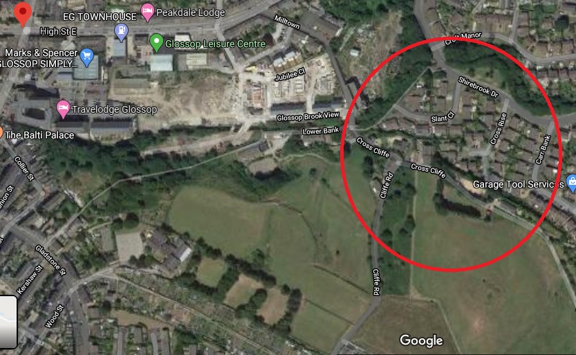
Cross Cliffe is broadly that area circled in red.

Although now it gives its name to a road, it was once an area (circled in red above) which  started at the bottom of Cliffe Road and lead down to Hurst Clough. The entry in the book reads:

Cross Cliff (6″), crucem de Cresclyf 1285 For.

It gives the earliest example of the name (crucem de Cresclyf), the date of this (1285), and the reference for this example (For = Forest Proceedings). So far, so perfectly ordinary.

So then, Cross Cliffe… and then a thought. “Hang on a minute… Crucem de Cresclyf?

Now, I’ll admit it, my medieval Latin is about as good as my understanding of the language of the San people of Botswana – the one that uses clicks and other sounds. Or indeed, Klingon. I checked, and was – broadly – right (hurrah… personal victory, I’ll take that). I also checked with a real linguist (thank you AG), and was – broadly – backed up.

Crucem de Cresclyf: the cross of Cross Cliffe.

The cross? Which cross? Oooooh…

Bloody hell, thought I, and I went and bored Mrs Hamnett with this potential discovery. More research later, and I think I have just about convinced myself.

This, the first reference to Cross Cliffe, is taken from a 1285 document which gives a description of the boundary of land owned by a certain Thomas le Ragged. Thomas was a forester in the Peak Forest, and was given the lands by William Peverel, son of William the Conquerer and resident of the castle in Castleton. These lands included the hamlet of Whitfield. The descendants of Thomas le Ragged sold the Whitfield portion in 1330 to a John Foljambe, and from there it was portioned off and sold in lumps (Whitfield really does have an interesting history).

The description of the boundary of this land reads:
Required by the Foresters and others concerning the metes and bounds of the land of Thomas le Ragged of Fernley who claimed liberties, who say, that the metes and bounds of the said lands of the said Thomas begin at the Bridge of Welegh by the Royal Way to the (cross) to Crescliff, and from the said cross by certain caves (fovia) up to Routing-clought, and from Routing to Brownhegge, and up to the Waynstones, and from Waynstones descending to the Hocklow, and from Hocklow descending to the water of G’wit and by the water of G’wit ascending to the wood of Horworth.

Boundaries are based on and related to landscape features, and always incorporate immovable and visible objects, ones that can’t be disputed. Now, out of this, only a few points are identifiable. Whaley Bridge, Cross Cliffe, Hucklow, the River Goyt (G’wit), and possibly the Wain Stones on Bleaklow (although, I suspect that it may reference another ‘Wain Stones’, now lost to us). The other places I have not been able to identify (any help would be appreciated), and I’m not sure what to make of the caves – are these literal or figurative, and does a cave (fovia in the text) in the 14th century mean the same as it does now.

I digress, as the important bit here relates to Crosse Cliffe, or rather “crucem de Cresclyf” as it is in the orginal – the cross of Cross Cliffe. Not the bridge at Cross Cliffe, or the brook at Cross Cliffe, but the cross at Cross Cliffe. This is at a time when they didn’t use metaphors or flowery terms for place names – if it says the cross at Cross Cliffe, it meant the cross at Cross Cliffe. A physical, actual, stone cross. One that has been there long enough for everyone to know where it is, and use it as a point of reference. Which is very interesting. A previously unknown cross.

Its location also would support this. It would be situated on a crossroads – a favoured spot for crosses of this sort (Whitfield Cross for example). The present layout of the roads does not show this easily, but they have been changed, probably in the 18th century – I’ve got a post almost ready to go that explains all that, but here is a map to help:

Cross Cliffe 3
The cross roads, with Cliffe Road coming from the bottom, Cross Cliffe (the road) on the right, Bank Street on the left, and the original line of the road heading down to the bridge/ford over Hurst Brook, and on to Old Glossop. The green circle marks the – hypothetical – location of the cross. For orientation, the red star marks the location of what was Volcrepe.

The upcoming blog post will make a lot more sense of this area, but for now, roll with it!

Cross Cliffe 5
This is broadly the area in which the hypothetical cross would have stood. It was once a crossroads, with the road having continued on and down to Hurst Clough 50m away. Probably.

Importantly, the cross would have stood at the border between the manors of Whitfield and Glossop – effectively Hurst Clough – and boundaries like this are exactly the sort of places that crosses are erected. Then there is the name Cross Cliffe. I had always, at the back of my mind, assumed that it meant the place where you crossed the cliff – perhaps a tall edge over Hurst Clough that no longer exists – or simply references the footbridge here. Well no. Delving further into the etymology of the name, it is derived from ‘Cliff‘ meaning a steep river bank, and ‘Cross‘ meaning, well, a cross. The name is literally ‘the steep river bank with a cross on it’, and crucem de Cresclyfe is then ‘the cross of the steep river bank with a cross on it‘. This a perfect description of that monster of a hill –  it drops from 650ft at Bright’s Terrace to 500ft at the bridge over Hurst Clough – a 150ft drop over roughly 1000ft.

Placename evidence, coupled with a physical description, and a reading of the landscape and roads, seems fairly convincing. Well, to me anyway.

Now, there might a possibility that I am reading too much into this (‘surely not!’ groans everyone… I can hear you, you know! Don’t think I can’t). The ‘Cross of Cross Cliffe’ might refer to Whitfield Cross which would have been situated at the start of a small rise before the long steep slope down to Hurst Clough. If this is the case, then there is no need to look for another cross. However, I’m just not sure that this is the case. For one, the wording is too specific; “the cross of Cross Cliffe”, not just Cross Cliffe as an area –  Whitfield Cross would surely have been too far away to be the cross described there, it is firmly in Whitfield, not Cross Cliffe.

Cross Cliffe 6
The red circle marks the original location of Whitfield cross, the green circle marks the location of the hypothetical Cross Cliffe cross – a distance of over 1/3 of a mile.

Moreover, if Thomas’s land went to just the Whitfield Cross, then everything beyond that – including what is now Cross Cliff – would be outside of the described land. No, it makes sense his land went to the very edge of Whitfield, and the natural border of Hurst Clough, and it used a cross at the crossroads there as a marker.

What type of cross would it be, then? I would suggest that it was probably the same type as that which originally stood further up the same road at Whitfield – a 10th century Anglo-Saxon stone cross.

If this is correct, then where is the actual cross? 1000 years is a long time for a stone cross to survive. It may have been swept away in the iconoclasm of the Protestant Reformation of the Tudor period, or the iconoclasm that followed the Civil War, when crosses were routinely smashed – I read the other day of a Saxon cross that was broken up and used to fill a pothole in a road. However, the fact that Whitfield Cross survived these periods would suggest to me that Cross Cliffe would have likely survived, too. Perhaps we are looking at something more mundane; maybe it was accidentally broken, or worse, simply forgotten about as an important object, gradually falling into obscurity, to be lost in the hedgerows. Perhaps – and this really is a flight of fantasy – the stealing of the Whitfield Cross by the Cross Cliffe lads as a Mischief Night prank was not just a prank, and instead they were stealing a cross to replace theirs that was lost. It has never made sense that they would steal something so ridiculously large and heavy, so is this the answer? Well, probably not, but one can speculate wildly!

If anyone fancies joining me looking in hedgebacks and ditches for the original cross – after the current corona madness has subsided, obviously – then please drop me a line.

More soon – as I say, I have a whole post about the crossroads almost ready to go.

Until then, stay safe and stay inside, and take care of yourselves and each other.

And I remain, your humble servant,

RH

Archaeology · Graffiti · Pottery · Whitfield

Odd Bits and Pieces… and Cheese.

Well, this escalated quickly.

Apologies for the lack of posts recently, but things are a bit odd at the moment. Six weeks ago we were concerned about Covid19, but were still joking about it, and how it will amount to a fuss over nothing. Now, here I am in front of my computer in ‘lockdown’ for the foreseeable future, and a very real and sobering death count is still rising. It really is a strange time, and the country is a strange place; the start of it all reminds me of what my grandfather said of the ‘Phony War‘ – you knew something big was happening, but it wasn’t actually happening there and then. Well it is now.

Sadly, it also means that we have had to cancel all the tours and talks that I was involved in that were about to occur: in particular, the ‘By Seven Firs and Goldenstone‘ exploration of the legend and landscape of Alderley Edge, and the Objects Tell Stories evening of folklore and archaeology. Oh, and if you want to find out who I really am, you can watch me talking archaeology and ritual in the promo for that event here – I’m the one on the right.

More to the point, this has put something of a crimp in the Cabinet of Curiosities. Rest assured, though, I do have a backlog of posts that I have been trying to write that doesn’t involve me moving anywhere. And of course, there is now time to write… well there would be if Master Hamnett wasn’t being home schooled for the duration.

In the meantime let’s keep buggering on, as Churchill was fond of saying.

So I went for my state-mandated exercise the other day and found a few bits and pieces – random is the theme of today’s post. But first, a quiz. What’s this?

What
Ooooh, a mystery object!

I’ll give the answer at the end of the post… no peeking!

In the meantime, I spotted this sticking out of the ground:

What 2

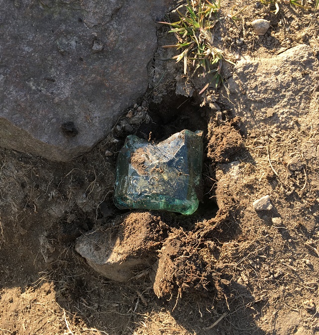
Ooooh, thought I. The greenish colour of the glass gave it away as being older than mere litter, along with the thickness of the walls. Master Hamnett helped me hoik it out of the ground, and cleaned up it looks like this:

What 4
The lovely pale green colour is the result of impurities in the silicone, and dates it to the Victorian period or thereabouts.

You can just about make out the word ‘Glossop’ impressed in the glass. This was likely to have contained either carbonated water or beer, but a brief search of bottles reveals nothing similar. More research is definitely needed.

The small white object next to it is a fragment of a clay pipe, but interestingly, it has a some molded decoration on it. Here it is in close-up.

What 3

This is a fragment of stem, just at the point where it joins to the bowl. It is unclear what the completed decoration would look like – foliage perhaps? Dating clay pipe stems is always tricky, but the decorated types are usually late, so late Victorian is about right.

We later came across this stone with the letter ‘H’ carved on it, and being a connoisseur of such graffiti, I had to collect it.

What5
A Hague Street ‘H’

It’s nicely executed with a flourish of decoration in the form of drilled holes between the arms of the ‘H’ – I’d give it a 7/10.

Right. That mystery object… did you get it? I believe you, honestly!

Ok, well, it’s a cheese press. Yes, you read that correctly! A cheese press. A thing for squeezing the whey out of cheese curds. Well, technically, it’s half of a cheese press – it’s missing the right half.

The square hole on the left is to house an upright pole which, along with another on the right, now missing, held the pressing weight in place. The circle and lines carved into the surface allowed the whey to run off, leaving behind the solids which are then matured to make cheese. Cheese was home made, or at least farm made in small batches, until relatively recently, so the press must  have belonged to a farm nearby, as you aren’t going to shift that stone any great distance, when others, closer, would do to fill a hole.

What
The mystery object again.

Here’s a complete one in Bashall Eves in Lancashire:

What Lancashire_Cheese_Press_-_geograph.org.uk_-_431556
Cheese press in Lancashire, and used to make, well, Lancashire Cheese. Image shamelessly stolen from Wikipedia.

  And here is another one carved in the same manner as ours:

cheese-press
The cheese press in Draycott in the Moors churchyard. Photograph is courtesy of their local blog, and I hope they don’t mind me stealing it – please visit the blog here, it’s very good.

This one caused a bit of confusion, apparently – read all about it at this wonderful blog.

In terms of date… who knows? Certainly not hugely old – possibly Victorian, but equally possibly earlier. The only other one I have seen (which is how I know what it is) is propped up where I work at The Blackden Trust, and was in fact carved on the reverse of an old gravestone dated to the early 18th century, which at least gives us a date to work with. I’m going to write a little more about this soon, as it involves two of my greatest loves – archaeology and cheese… if we could just work in wine somehow, then it would be perfect.

Incidentally, the press is currently being used to fill a pot hole in a trackway, which I think is a shame. Sigh… I’ll add it to the list of historical objects things that need to be hoiked out and displayed properly (along with Whitfield Cross and the Whitfield Guide Stoop) – I think it would look great displayed at the wells. Seriously, I think we need to do something about reclaiming our heritage, as it is being slowly eroded. The guide stoop is currently under 3ft of soil, and looks like it will be left like that, So then, who’s with me?

Right. I’m off do some more gardening.

Please stay inside and stay safe, and take care of yourselves and each other.

More soon, I promise, but until then I remain,

Your humble servant,

RH

Wells · Whitfield

A Furtive Furtle Around Freetown

I do love a good bit of alliteration.

What ho! What ho! What ho! Here is another post, as promised. This one is something of a hash, with multiple elements sharing the theme of Freetown (the road in Whitfield, not the capital of Sierra Leone, just in case you are here by mistake), and all presented in the style of a thriller novel. Enjoy.

The House(s) of Horror

I was perusing my namesake’s History of Glossop the other day, and came across this:

Freetown is really part of Hollincross Road (now Lane); it was called Freetown on account of the land being mostly freehold. The oldest house is no 28 built in 1809 and long owned and occupied by Robert Bennett. The chief rent was sold 29th June 1891 to Mrs. Wood for £52 who also bought the chief rents of the Unity Street property. No 28 was sold 16th January 1893 to Ald B. Furniss for £445, it has an outdoor licence attached to it.
The late Mrs. Sarah Hargreaves of Hadfield Street, remembered Freetown when this house was the only house in the road. On each side were hedges right down to Pikes Farm. The next houses to be built were Nos. 36 and 36a, in 1830 by Peter Handford, better known as “Peter before the Shower.” Many houses were built in 1835 and 1836 but the majority now existing were built during the last 60 years.

I live just by Freetown, and as I walk up and down it at least 8 times a week dropping off and picking up Master Hamnett from school, I have become very familiar with it.

Fr9
Freetown, looking west toward St James’s church.

It really is quite an interesting place; 1860’s housing cheek by jowl with 1960’s housing, and where widespread ‘remodelling’ in the 1960’s destroyed the homogeneity of the Victorian stone built heart of Whitfield. A shame really. I have mentioned bits around Freetown before (here, for example), and I’d really like to do a longer piece, particularly on Whitfield recreation ground (the park), but for now, I’ll keep this brief(ish)!

Anyway, the article got me wondering… and wandering. Are these old houses still in existence, and what else is interesting here in the Freetown area.

Well, the first part of the question was easily answered.

No.

The council pulled them down in the 1960’s. With no thought to heritage or the past in any form. I am constantly amazed and appalled at the shortsightedness of councils in the 1960’s – no effort was made to preserve, only to destroy and rebuild in a ‘better’ way. This thinking has had so many effects in the present day, not least of which is the destruction of close-knit multi-generational communities in Manchester in the name of ‘slum clearances’. I can angrily rant and rave about this all day, so I’ll move on.

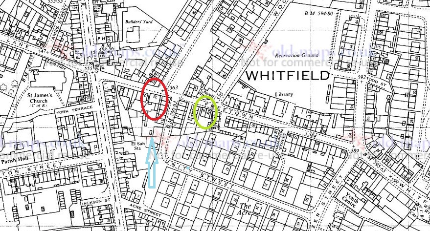
Number 28 is marked in red, 36 and 36a is marked in green. Ignore the blue arrow for now… we shall return to it.

Fr1
This is the 1968 1:2500 map, just before they were demolished.

What is interesting is that the roads Wood Street and Kershaw Street seem to have been aimed at them, almost as though the town planners were using these early buildings as reference points – which they almost certainly were. Kershaw Street (begun in 1834) runs from Bank Street to Number 28, and Wood Street (in 1913 was still under construction, though there as a track prior to that) runs from the opening toward St Mary’s School (and the allotments) off Gladstone Street to Number 36 and 36a. Here are the buildings in 1880, in much better focus.

Fr2
The 1880 1:500 scale… much clearer. And once again ignore the blue arrow… nothing to see here.

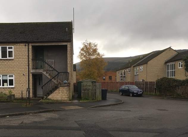
28 (red circle) seems to have been a large, oddly shaped, affair, and probably quite Georgian looking, with a central doorway and large windows. Actually, I’m amazed no photographs exist of 28 prior to its demolition – I should peruse the Glossop Heritage Trust archive for some – you never know what might be lurking. Here is what it looks like now:

Fr4
The location of 28 Freetown, the oldest building in the area.

Number 28 would have occupied some of the same space as the building there now, and to the right, but would also have come up to the edge of the path, where the grass is. It’s nice to know that at least some of the footings and foundations will be preserved below ground, and it makes you wonder at the sort of pottery and bits that lurk in the garden there… Given how busy Freetown and area is, and how many houses are here, it’s hard to picture what it would have been like as Sarah Hargreaves remembered it, with this being the only house from here to Pikes Farm – amazing.

Numbers 36 and 36a (in green) were semi-detached (well, terraced) stone built affairs, probably very similar in design and style to many of the other houses built around the same time in the area. I love the nickname given to the builder, Peter Handford – ‘Peter Before The Shower’ – what on earth could it mean? Any thoughts, anyone?

Anyway, here is what is there now:

Fr5
The modern view, Whitley Nab in the background.

Numbers 36 and 36a stood broadly where the right side of the current building is, the shed, and out into the road – in a sense, the centre of the photograph.

So there we have it… a loss of history, sadly. I wonder if the people who live there now know what they are living on (if you are reading this, can I have a poke around your garden?).

The next three parts of this post are all based around this small area, so we’ll skip to an aerial photograph of the place, with each area marked in coloured circles. All will become clear in a moment, don’t worry!

Fr7
It’s all getting a bit ‘Olympic-y’ around here now.

The Blue Arrow

So, that blue arrow! whilst I was sorting that lot out, and doing some map work, I came across mention of a well (check out the blue arrows in the above maps, you can see it). A well would have been important to the people of Whitfield, as they always had issues with the water supply in the area (this is a whole other blog post, we’ll save it for another day). The word ‘well’ implies a reliable water source, and importantly, some form of structure associated with it – even if only a trough. Indeed the 1880 1:500 map (above) shows just such a structure, with the well placed against what seems to be a wall. I had high hopes of finding something.

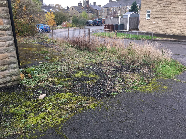
Alas, ’twas not to be. There is quite literally nothing even remotely old about any of the area where the well once stood – it has all been remodelled. Here is the location of the well as marked on the map:

fr13
This place is circled in green in the aerial photograph above.

I would think it would be difficult to destroy a well completely – it is flowing water after all, and if you stop it up, it will just bubble elsewhere. This, coupled with the fact that it is not marked on any map past 1880 suggests that it might have simply dried up. Oh well.

The Electrifying Edifice

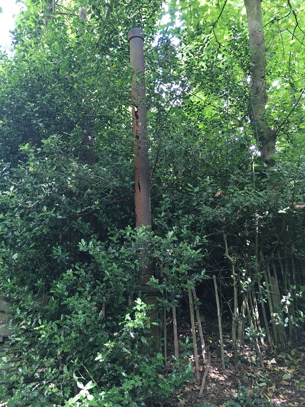
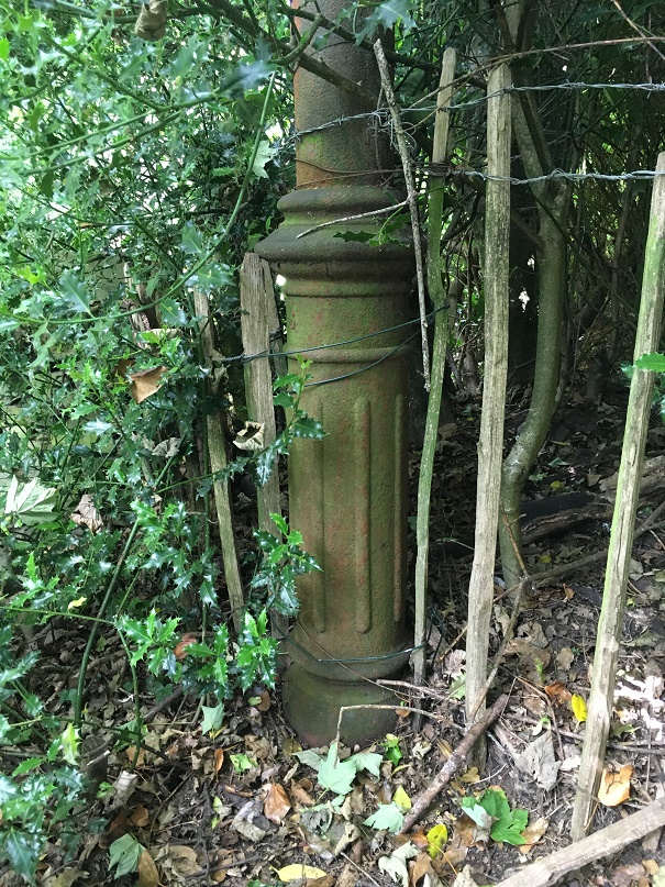
So, right next to the well location (and circled in red) is this:

Fr6

A vaguely classical temple looking electricity substation, sitting seemingly on its own in the wilderness of this part of Kershaw Street – it’s all a bit spooky, and I have the sneaking suspicion that the ‘Danger of Death’ notices refer not to the electricity, but something that lives inside it. It’s probably 1920’s or 1930’s in date, and clearly supplied power to the area, and indeed still does, quite remarkably surviving the 1960’s demolition. Above the doorway is a lintel with the letters ‘SHMD’ carved into it – a sure sign of its age, as it would just be a plastic sign now.

fr11
The Stalybridge, Hyde, Mossley and Dukinfield Tramway and Electricity Board

A brief search on the internet reveals that it refers to the “Stalybridge, Hyde, Mossley & Dukinfield Tramways & Electricity Board”. They have an interesting history in this area (which you can read about here and here), but briefly they were founded in 1901, supplied electricity to the named places (and Glossop), as well as running bus services and trams, and eventually became part of Norweb in 1948. So there you go.

The Mystery of The Disappearing Gatepost

As I was navigating the streets via Google maps, trying to work out where the well was, I spotted something interesting at the very bottom of the continuation of Kershaw Street, at the left hand (easterly) turn along a pedestrianised track (circled in blue in the above aerial photograph).

Fr3
Carved, and covered in paint, it stands guard.

It looked to me like a very out of place gatepost, reused as a bollard to prevent ne’er-do-wells riding motorbikes and cars along the pedestrianised bit. You can even make out the carved shoulders, making it reminiscent of a milestone (and here). It is certainly jarring against the 1960’s concrete that is used in this area. Interesting, thought I.

So off I popped to have a look.

Nope. Nothing. Just a tarmacked hole in the ground where once it stood.

Fr10
A patch of tarmac is all that remains.

I had a look around in hedgebacks and ditches, but found nothing. Something has happened to it since May 2009 when the Google streetview image was taken… but what? Now, nobody has stolen it, clearly – it would weigh a serious amount. And if the council took it away, then why? It’s all a bit of a mystery; if anyone knows anything, then please drop me a line.

The Nailbiting Conclusion

And to end with, some archaeology. As I’m sure you know, I like to pick up interesting things that I find (I can hear Mrs Hamnett sighing in agreement). Now, within the space of a single week, I picked up two copper nails from Freetown; one at the upper end, and another at the lower, nearest St James’ church. I love these things – such history in a tiny object – and I’ve blogged about them before, here. And have also come across them elsewhere in Glossop.

Fr8
I love these things.

I always have my eyes on the ground (to the point I am worried about developing a stoop!), but to find two in a week seems oddly lucky… perhaps I should play the lottery. Or has my luck been ‘used up’ on worthless copper nails? Anyway, keep looking people, and get in contact with anything you find.

Right-ho, that’s about all I have at the moment. A bit of a hotch-potch, to be honest, but I hope entertaining, or at least diverting. If you have any comments about the blog post, or just in general about Glossop’s past, please feel free to email me. I have a lot more bits and pieces to blog about, and am trying to better manage my time, so hopefully I’ll have something more to you in the next week or so. Until then, I remain.

Your humble servant,

RH

Bench Marks

A Lost Bench Mark

Morning all. Apologies for the recent lack of activity; all usual reasons apply, but we’ll spare the grovelling and move swiftly on.

I was contacted recently by the wonderful Geoff Bell, who informed me that he knew the whereabouts of one of the bench marks that had been declared lost by me in this post. Specifically, this one.

GB BM
The location of the no longer missing bench mark, 562.5 ft above sea level. 

How wrong I was! I popped over to see him (and his wonderful garden), and he showed me the stone and mark. It wasn’t easy to get to, but at least I can now tick it off my list.

Here is the stone:

GB BM1
Stood at the end of, and incorporated into, the wall.

The stone is interesting. It is clearly in its original place, with the current wall being relatively recently added, but following the line of the original wall. This original wall used the stone as a reference point (it curves to meet it), and it was clearly here before the wall was built, leading to the question of… what was it? It seems not to have functioned as a gatepost, it has no evidence of metal ‘fixings’, nor is it shaped like other gateposts, and it would be an odd place to have it. It is possible that it was a free-standing standing stone, perhaps even prehistoric, but it is difficult to prove. It might also have marked a track, and although the probably Medieval or earlier Bank Street runs close by, it’s way below (some 39 ft and more, to be precise), and no one moves a stone that big very far up hill. No, it’s a bit of a mystery, but hey ho.

So, this is what 562.5ft above sea level looks like! Apologies for the close-up – there was no easier way of taking the shot – it really was quite inaccessible!

GB BM2
Exactly 562.5ft above sea level. 

So there we have it. My sincere thanks to Geoff (lovely to meet you) for alerting me to this. If anyone else wants to get in touch and tell me about anything interesting, please do… especially if it involves bench marks!

Oh, and on the way out of his garden, I saw these striking Fly Agaric mushrooms:

GB BM3
Amanita Muscaria – the Fly Agaric. 

Wonderful to look at, and used by shamen throughout the world to commune with the other worlds and work magic. Interesting, but I really wouldn’t recommend it.

Right. I ‘ll try and get another post done this evening, but for now, I remain.

Your humble servant

RH

Bench Marks · Graffiti

The Walk Part 1: Carvings

Greetings all. I’m back.

So, I have returned. I’m not going to bore you with the usual apologies for a lack of posts… let’s just ignore it and awkwardly move on.

Interesting things have occurred since I last blogged. I no longer work at a certain local museum, which means I now have more time to spend doing this sort of thing. For the first time in too many years, I put a trowel in the ground and went back to my roots of excavation rather than the academic theorising of more recent years. Even if it was only a 1m x 1m test pit, it was a good feeling, particularly as it was at Melandra, where my namesake excavated in the early part of last century. I didn’t find anything interesting (a piece of flint amongst some modern backfill), but the project as a whole seems to have made a significant discovery… more about that another time.

I have also recently returned from Florida, spending some time with my amazing daughter (hello Evie). Nothing archaeological to report from there, but we did find some nice bits of Native American flint in a flea market – I’ll blog about it, as it’s fun to look at.

So then, today’s post is a bit of a placeholder. I have almost finished a long and interesting post about a wall (stop groaning… I can hear you, you know!), but I need a few more photographs. Until then, I’ll post a short companion piece.

Mrs Hamnett, Master Hamnett, and myself, went on a short ramble the other day, to blow away the cobwebs so to speak (not a reflection on Mrs Hamnett’s housekeeping…). Being short in the leg department, and peculiarly large in the whingeing department, young Master Hamnett sets the length of our walks these days. And so, with much faffing and snot on the face, we set off “up and over” – that is, past The Beehive, along Hague Street,  left into the field, and then follow the path round until we arrive at Fieldhead, and then down to The Beehive (or if we are feeling full of energy and less full of whinge, we push on to Whitfield Cross (the cross) and then back. The last few times we have done this, I have picked up some bits and pieces of pottery and glass along the path – nothing earth shattering, but interesting nonetheless. I’ll post them tomorrow, as well as a third installment – the original post – later this week. Today’s post is made up of two of my obsessions: carved graffiti and benchmarks.

This is the route we took.

Wall Walk
We didn’t get as far as the cross, but instead cut back towards the Guide Stoop. The red lines show the route taken (1898 1:2500 OS map via old-maps.co.uk)

Bits and pieces of pottery were along the path, as I say, but I stopped to take these photographs in the areas marked with a green circle.

The first, in the lower circle… a benchmark! I’ve not posted many recently, and I really must address that as, well, they’re great. There are several on this route, as you can see from the map above, and a few hidden in field walls in the middle of nowhere. I’d like to do an odyssey at some stage, and track them all down – if anyone fancies joining me, give me a shout! Anyway, here is the benchmark in all its glory:

Wall - BM
Fairly standard choice of immovable object – a gatepost – but some nice detailed carving on the mark.

This is a bit of an odd one. It’s clearly a bench mark, it’s clearly on an immovable object, and the gate is clearly marked on the maps, but… there is no bench mark marked on the map at that point – check it out in the map above. The nearest is a spot height of 777 ft above sea level. Spot heights are recorded OS heights above sea level, but are not marked on the landscape by carving them – they serve more as a guide, than a definite point. I trawled through a pile of maps, and eventually found a spot height at that point on the 1954 OS map of 779 ft above sea level. It is probably a late entry in the Ordnance Survey, and it seems whilst they marked it on the stone, they forgot to mark that on the map. If there was a category for ‘rare’ types of bench marks, this would surely be one (and no, I’m not looking for bench mark collectors websites; I have too many ‘collections’ as it is, if I get sucked into bench mark collecting, Mrs Hamnett will almost certainly divorce me*). The gatepost itself is interesting; it appears to be a roughly shaped upright stone, rather than a carefully dressed, more traditional, post. Whilst one is hesitant to say ‘standing stone‘ for several reasons, it is quite common for them to be used as gateposts, and a brief glance at all the other gateposts in the area reveals them to be like the photograph below – shaped properly for the job.

Here is the upper green circle… carved graffiti!

Wall - Carving
Another gatepost. Fieldhead is in the background.

 An inexperienced hand, but very clearly writing letters. At the top, we have a ‘T’ and a ‘B’ or ‘R’, and on the left, running down, are a ‘T’, a ‘B’, and an ‘O’, and there are other marks carved around the top, but nothing recognisable. The Ts are carved quite nicely with serifs, but overall it’s a bit messy… 3/10?

Right, that’s all for today. As I say, I have two more related posts almost ready to go (tomorrow for at least one of them, if I get chance), and lots more to go after that.

As always, comments are very welcome, and please feel free to email me with any information or questions.

More soon, I promise.

But until then I remain, your humble servant.

RH

*Alright, so I lied. I did check. And there are so many. So like a moth to a flame… apparently, we are called ‘bench mark baggers’. Here are two websites to whet your appetite: One is the central bench mark database, which is worth an explore, and the other is a blog run by someone worryingly like me, well worth checking out. I might be single again very soon.